Page 1
August 2012 28
CHAPTER 4. EXISTING CONDITIONS
EXISTING BIKEWAYS
Existing on-street bikeways were inventoried in August 2011 using a GPS enabled video camera to
record bikeway features such as signage, striping, and stenciling. These features were reviewed to
ensure that bikeways complied with applicable design criteria, and the facilities were broken down
into the following three categories:
Class II Bike Lane – meets all applicable design criteria
Class II Bike Lane with Minor Deficiency – does not meet all applicable design criteria, but
could meet Class II standards with relatively minor improvements (i.e., additional signage,
striping, stencils, etc.)
Class II Bike Lane with Major Deficiency – does not meet all applicable design criteria, and
would require relatively high cost improvements to do so (i.e., roadway widening)
In addition to the inventory conducted of on-street
facilities, three paved Class I bike paths currently exist
in Yuba County, and were included in the inventory.
One facility provides a connection between developed
areas on either side of Marysville Road in the rural
community of Dobbins, another connects Erle Road to
River Bank Road and recent development to the north
in the community of Linda, and the third parallels
Rupert Avenue in Linda. According to the inventory,
Yuba County has approximately 66 miles of existing
bikeways, as shown in Table 2. This total includes
Class II bike lanes with minor deficiencies, but does
not include lanes with major deficiencies.
Class I bike path bridge in Dobbins
Page 2
August 2012 29
TABLE 2: LENGTH OF EXISTING BIKEWAYS BY BIKEWAY CLASSIFICATION
Bikeway Classification Mileage
Class I Bike Paths 1.1
Class II Bike Lanes 28.9
Class II Bike Lanes with Minor Deficiencies1 35.7
Class III Bike Routes 0
Total 65.7
Note:
1. These facilities do not meet all applicable design criteria, but could meet Class II standards with relatively minor improvements
(i.e., additional signage, striping, stencils, etc.).
Source: Fehr & Peers, 2012
Figure 3 shows the existing bikeways within Yuba County. Class II bike lanes exist on several of the
County‟s collector and arterials streets, particularly within the communities of Olivehurst and Linda
located in the southern portion of the County. Limited Class II bike lanes also exist in the northern
foothill communities of Loma Rica and Brownsville.
Page 3
Existing Bicycle NetworkFigure 3
!
!
!
!
!
!
!
!
!
!
!
SutterCounty Placer
County
ButteCounty
NevadaCounty
Linda
Loma Rica
Beale AFB
Wheatland
Marysville
Olivehurst
CamptonvilleChallenge-Brownsville
LaPo
rteRd
Ponderosa Way
Wild
cat T
rl
Hilory
Way
h
McCra
nkLn
Aero Pines North
Will
owG
len
Rd
Hill
Rd
Smith
Rd
Kimberly
Rd
Loop
Rd
Daphne Way
Fallw
ood
Ln
Littl
efie
ldR
d
W
East
view
Dr
Lila
c W
ayLambert R
d
Ahart Ct
Virginia Rd
Loma Rica Rd
Fruitland Rd
!
!!!!!!
!
!
N Beale Rd
Feat
herR
iver
Blv
d
Arboga Rd
Riv
erO
aks
Blv
d
Grif
fith
Ave
Plumas Arboga Rd
Algo
don
Rd
Leach Rd
Ella Ave
Broadway Rd
Lindhurst Ave
Chi
ppew
aTr
l
P ow
erlin
eR
d
Oli v
ehu r
stAv
e
McGowan Pkwy
Mer
cury
Way
Country Club Rd
Skyway
Dr
Hoffman Rd
Grand Ave
Murphy Rd
Plumas Ave
Seventh Ave
Dye
Rd
Kam
ada
Ln
Linda Ave
Anderson Ave
Rupert Ave
Bernice Ave
Hale Rd
Riverside
Dr Alicia Ave Riverbank Dr
Pebble Trl
Hof
fman
Plu
mas
Rd
Plumas St
Old
Mar
ysvi
lleR
d
Garden Ave
Rich Rd
Plumas Lake Blvd
Eleventh Ave
Rd
Edgewater Cir
Vict
oria
Ln
Wes
t Ella
Ave
N Beale Rd
n
Inset A
ÃÅ70
Laurellen Rd
Linda Ave
Babb
ingt
onRdDavis Rd
North
Leve
eRd
BSt
Jack
Slo
ugh
Rd
Simpson Ln
Inset B
Inset C
Inset D
AB
C
D
RailBicycle Facilities! ! !! ! Class I Bike Path
Class II Bike LaneClass II Bike Lane with Minor DeficienciesClass II Bike Lane with Major Deficiencies
Marysville
F e a t h e r R i v e r
Y u b aR i v e r
ÃÅ20
ÃÅ65
ÃÅ70
ÃÅ70
Fe
at h
er
Ri v
er Y u b a
Ri v
e r
ÃÅ70
ÃÅ65
Page 4
August 2012 31
REGIONAL CONNECTIONS
Regional travel between Yuba County and surrounding jurisdictions is limited due to the location and
terrain of the County, with the exception of a strong regional link to Yuba City located on the
opposite side of the Feather River in Sutter County. Residents of Sutter and Yuba counties utilize
the two bridges over the Feather River connecting Marysville to Yuba City to travel between the two
jurisdictions. From Marysville, limited connections currently exist between bikeways within the City
to bikeways in the unincorporated portions of the County. One notable exception is an existing
bikeway on Simpson Lane that provides a connection across the Yuba River to Ramirez Street in the
City of Marysville.
PAST EXPENDITURES ON BICYCLE FACILITIES
Based on the inventory of the existing bikeway network, an estimate of past expenditures is
possible. Table 3 provides a summary of the past Countywide expenditures on bicycle facilities, in
2011 dollars. Chapter 7 presents an explanation of 2011 per mile costs for the three bikeway
classes.
TABLE 3: PAST BICYCLE FACILITY EXPENDITURES
Bikeway Classification Mileage 2011 Per Mile Cost Expenditure (in
millions)
Class I Bike Paths 1.1 $528,000 $580,800
Class II Bike Lanes1 64.6 $686,400 $44.3 million
Class III Bike Routes 0 $1,580 $0
Total 65.7 N/A $44.9 million
Note:
1. Includes Class II lanes with minor deficiencies as previously described in this chapter.
Source: Fehr & Peers, 2012
As shown in Table 3, the past countywide expenditures on bicycle facilities total approximately $44.9
million. Since a substantial portion of County‟s bike lanes were constructed as part of new
development, the County‟s actual share of the total expenditure on bicycle facilities is less than
$44.9 million.
Page 5
August 2012 32
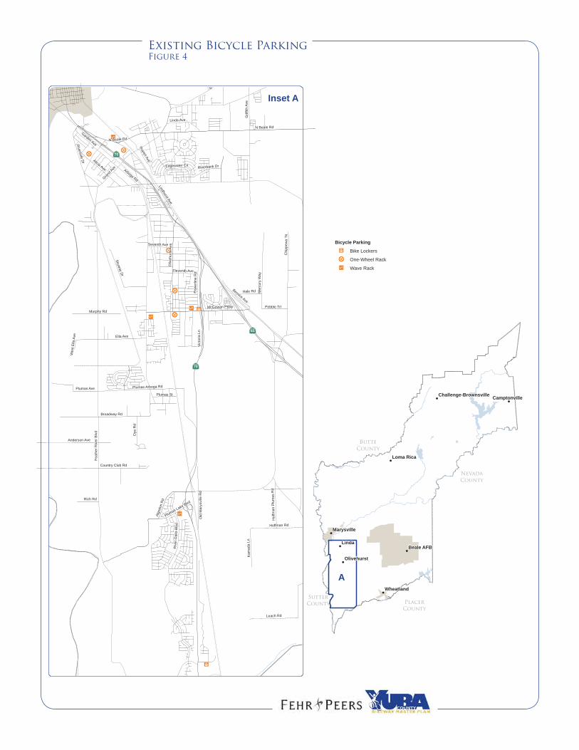
SUPPORT FACILITIES
Support facilities include bicycle parking, shower
and changing space, and secure storage for bicycle
gear. Short-term bicycle parking is provided at
several locations in the southern portion of the
County, including select commercial
establishments and schools. Few long-term
bicycle parking and shower/locker facilities
currently exist. Exceptions include a limited
number of bike lockers available at local commuter
bus stops provided by Yuba-Sutter Transit (see
image to right). Figure 4 displays the locations of
existing bicycle parking facilities.
The Yuba County Code of Ordinances, Title 12
(Zoning) was updated within the past five years to require that bicycle parking “be provided in
connection with the erection, major alteration, expansion or establishment of new land use.” This
ordinance contains minimum requirements for bicycle parking that vary by land use type, and relates
the number of bicycle parking spaces to the required number of automobile parking spaces. The
bicycle parking ordinance also provides guidance on the placement, type, and design of bicycle
parking facilities, and states that larger employment centers with 50 or more employees “and
projects with multiple buildings should utilize a combination of short (bicycle racks) and long-term
(bike lockers) bicycle parking facilities.” Appendix D includes the full ordinance.
MULTIMODAL CONNECTIONS
Yuba-Sutter Transit serves as the primary transit provider within Yuba County, and offers both fixed-
route and demand-responsive bus service. Four fixed local routes provide service within central
Yuba County from 6:30 AM to 6:30 PM on weekdays and 8:30 AM to 5:30 PM on Saturdays on 30 to
60 minute headways. In addition to fixed local route service, rural routes provide service to the
foothills communities of Brownsville, Oregon House, Willow Glen, and Loma Rica Tuesday through
Thursday and to Wheatland on Tuesdays and Thursdays only. Commuter express service is
provided to Sacramento on weekdays.
All Yuba-Sutter Transit buses are equipped with front-mounted bike racks that accommodate at least
two bicycles, available on a first-come, first-served basis. Some buses, including those that provide
service to the foothills, have racks that accommodate three bicycles. Bikes are not allowed inside
the buses unless there are no open positions on the bike rack and it is the last bus of the day on a
local fixed route. Otherwise, passengers must wait for the next bus with an available position on the
bike rack. Bus stops do not typically feature bike racks. Yuba County’s two Yuba-Sutter Transit Park
& Rides (the McGowan Park & Ride and the Plumas Lake Park & Ride), offer a limited number of
bicycle storage lockers that are available for rent. Figure 5 displays existing Yuba-Sutter Transit
routes and stop locations.
Long-term bike parking at a Yuba-Sutter Transit park-and-ride
Page 6
Existing Bicycle ParkingFigure 4
!
!
!
!
!
!
!!
SutterCounty Placer
County
ButteCounty
NevadaCounty
Linda
Loma Rica
Beale AFB
Wheatland
Marysville
Olivehurst
CamptonvilleChallenge-Brownsville
IIS
ÒÐÐ
ÒÐÐ
ÒÐÐ
ÒÐÐ
ÒÐÐIIS
IIS JU
IIS
JU
N Beale Rd
Feat
herR
iver
Blv
d
Arboga RdR
iver
Oak
sB
lvd
Grif
fith
Ave
Plumas Arboga Rd
Algo
don
Rd
Leach Rd
Ella Ave
Broadway RdLindhurst Ave
Chi
ppew
aTr
l
P ow
erlin
eR
d
Oli v
ehu r
stAv
e
McGowan Pkwy
Mer
cury
Way
Country Club RdSkyw
ayD
r
Hoffman Rd
Grand Ave
Murphy Rd
Plumas Ave
Seventh Ave
Dye
Rd
Kam
ada
Ln
Linda Ave
Anderson AveRupert Ave
Bernice Ave
Hale Rd
Riverside
Dr Alicia Ave Riverbank Dr
Pebble Trl
Hof
fman
Plu
mas
Rd
Plumas St
Old
Mar
ysvi
lleR
d
Garden Ave
Rich Rd
Plumas Lake Blvd
Eleventh Ave
Rd
Edgewater Cir
Vict
oria
Ln
Wes
t Ella
Ave
N Beale Rd
n
Inset A
ÃÅ70
A
ÃÅ70
ÃÅ65
Bicycle Parking
JU Bike Lockers
ÒÐÐ One-Wheel Rack
IIS Wave Rack
Page 7
Existing Transit FacilitiesFigure 5
!
!
!
!
!
!
!
!
IbI0
eTIb
Ib
Ib
SutterCounty Placer
County
ButteCounty
NevadaCounty
Linda
Loma Rica
Beale AFB
Wheatland
Marysville
Olivehurst
CamptonvilleChallenge-Brownsville
LaPo
rteRd
Ponderosa Way
Wild
cat T
rl
Hilory
Way
h
McCra
nkLn
Aero Pines North
Will
owG
len
Rd
Hill
Rd
Smith
Rd
Kimberly
Rd
Loop
Rd
Daphne Way
Fallw
ood
Ln
Littl
efie
ldR
d
W
East
view
Dr
Lila
c W
ayLambert R
d
Ahart Ct
Virginia Rd
Loma Rica Rd
Fruitland Rd
eTIb
Ib
Ib
N Beale Rd
Feat
herR
iver
Blv
d
Arboga Rd
Riv
erO
aks
Blv
d
Grif
fith
Ave
Plumas Arboga Rd
Algo
don
Rd
Leach Rd
Ella Ave
Broadway Rd
Lindhurst Ave
Chi
ppew
aTr
l
P ow
erlin
eR
d
Oli v
ehu r
stAv
e
McGowan Pkwy
Mer
cury
Way
Country Club Rd
Skyway
Dr
Hoffman Rd
Grand Ave
Murphy Rd
Plumas Ave
Seventh Ave
Dye
Rd
Kam
ada
Ln
Linda Ave
Anderson Ave
Rupert Ave
Bernice Ave
Hale Rd
Riverside
Dr Alicia Ave Riverbank Dr
Pebble Trl
Hof
fman
Plu
mas
Rd
Plumas St
Old
Mar
ysvi
lleR
d
Garden Ave
Rich Rd
Plumas Lake Blvd
Eleventh Ave
Rd
Edgewater Cir
Vict
oria
Ln
Wes
t Ella
Ave
N Beale Rd
n
Inset A
ÃÅ70
IbI2
Laurellen Rd
Linda Ave
Babb
ingt
onRdDavis Rd
North
Leve
eRd
BSt
Jack
Slo
ugh
Rd
Simpson Ln
Inset B
Inset C
Inset D
AB
C
D
Yuba-Sutter TransitI0 Amtrak Bus Stop
Ib Park and Ride
eT Transfer CenterLocal Routes
1: Yuba City to Yuba College3: Olivehurst to Yuba College4: Marysville Loop6: Linda Shuttle
Sacramento RouteCommuter/Midday Express
Rural RoutesFoothill RouteLive Oak RouteWheatland RouteRail
Marysville
F e a t h e r R i v e r
Y u b aR i v e r
ÃÅ20
ÃÅ65
ÃÅ70
ÃÅ70
Fe
at h
er
Ri v
er Y u b a
Ri v
e r
ÃÅ70
ÃÅ65
Page 8
August 2012 35
EXISTING AND FUTURE LAND USE PATTERNS
The Community Development Element of the Yuba County General Plan establishes land use
designations and guidelines for land use density and intensity, in conjunction with goals and policies
that reflect the County‟s intentions. The General Plan recognizes that Yuba County has three
distinct physiographic areas that have developed, and will continue to develop differently from one
another: the valley floor, foothills, and mountains. The General Plan describes the different types
and distributions of land uses within these three areas as follows:
The valley floor is the most developed part of the County and is home to most of its
residents and businesses, although residential development and some business
development is also scattered throughout the foothills. The County‟s cropland is also
focused on fertile soils of the valley floor, while most grazing land is located in the foothills.
The foothills have some developed rural communities, as well as agricultural, forestland,
and natural open spaces.
Mountain areas have a large amount of public land with open-space oriented uses, as well
as some small, rural communities and a variety of agriculture and forestry.
The General Plan envisions additional development opportunities in both valley and foothill
communities, including infill development in already developed portions of Olivehurst and Linda, as
well as new development in designated community plan and specific plan areas (see Figure 6 for the
General Plan land use diagram). The land use designations provided in the Community
Development Element include separate “valley neighborhood” and “rural community” designations
for future development. These designations allow for flexibility, and reflect the understanding that
new development should be appropriate to its
surrounding.
The vast majority of developed land within Yuba
County, including development within the County‟s
two municipalities as well as developed land in
unincorporated areas, is located on the valley floor.
Today, nearly three-quarters of the County‟s
approximately 72,000 residents live in unincorporated
areas, most of which are in the southern portion of
the County. Much of the recent development in
unincorporated areas of the County has occurred on
former agricultural lands.
Vast swaths of active agricultural lands surround the
developed areas of the valley floor. Apart from
The valley floor transitions to foothills and mountains in eastern Yuba County
Page 9
August 2012 36
agriculture, the second largest land use type on the valley floor is Beale AFB, which occupies 23,000
acres, and serves as the County‟s largest employer. Yuba College is also located on the valley
floor, in the unincorporated community of Linda.
The land surrounding Yuba College on the north, south, and east sides is included within the East
Linda Specific Plan. According to the East Linda Specific Plan, the area is forecasted to have a
population of approximately 15,580 residents at full build-out. The larger Plumas Lake Specific Plan
is also located on the valley floor, south of the developed unincorporated community of Olivehurst.
At full build-out, this area is forecasted to eventually house a population of nearly 30,000 residents.
Although most development within Yuba County has occurred on the valley floor, several smaller
unincorporated communities exist throughout the foothills and mountainous areas of the County,
including Loma Rica, Challenge, Brownsville, Browns Valley, Oregon House, Dobbins, Log Cabin,
Camptonville, Smartsville, Rackerby, Collins Lake, Strawberry Valley, and Camp Far West. Some of
these communities have experienced limited new development in recent years, and the General
Plan Community Development Element allows for growth within designated rural community areas.
Page 10
General Plan Land useFigure 6
Page 11
August 2012 38
BICYCLE ACTIVITY CENTERS
Certain activity centers such as elementary,
intermediate, and high schools, colleges,
recreational areas, parks, and community centers
(commercial, financial and general employment)
require special emphasis because of their potential
to attract bicycle travel. The Yuba County BMP
attempts to provide at least one connection to each
of these major bicycle activity centers.
Yuba County recognizes the importance of safe
pedestrian and bicycle routes to school sites. The
County will continue to work cooperatively with
local school districts in developing and improving
safe pedestrian and bicycle travel routes to schools.
EXISTING AND FORECAST BICYCLE USE
Table 4 displays the bicycle mode split for Yuba
County derived from journey-to-work data collected
as part of the 2000 U.S. Census. As shown in
Table 4, approximately 0.4 percent of Yuba County
residents use a bicycle as their primary means of
transport for work trips. For commute trips of
residents who work within Yuba County, the rate is
approximately 0.6 percent. These figures do not
account for occasional bicycle commuters, or
include non-commute bicycle trips to locations such as
schools or shopping centers. In most areas, the
percentage of non-commute bicycle trips is greater than the percentage of bicycle commute trips as
commute trips tend to be longer and less bikeable than shopping or school-related trips. Therefore,
Yuba County‟s overall bicycle mode split is likely higher than the figures presented in Table 4.
Yuba College is a major activity center on North Beale Road
Schools are common bicycle trip generators
Page 12
August 2012 39
TABLE 4: EXISTING HOME-WORK MODE SPLIT
Mode Home-Work Mode Split
Intracounty1 Overall
2
Drive Alone 71.11% 73.34%
Carpool 15.19% 17.74%
Public Transportation 0.36% 0.64%
Bicycle 0.57% 0.41%
Walk 3.85% 2.35%
Other3 8.91% 5.45%
Notes:
1. Intracounty home-work trips account for residents of Yuba County that work in Yuba County
2. Overall home-work trips account for all Yuba County residents regardless of where they work
3. Includes work at home, motorcycle, etc.
Source: 2000 Census Journey to Work
According to the California Department of Finance, the population of Yuba County as of 2010 was
approximately 72,000. Data obtained from the California Employment Development Department
indicates that approximately 23,100 Yuba County residents are currently employed. Therefore, just
fewer than 100 Yuba County residents currently use a bicycle as their primary means of
transportation to work. Yuba County‟s home-work bicycle mode split is about half the California
statewide average bicycle mode split (0.8 percent).
Yuba County‟s goal is to achieve a bicycle mode share of three percent by the year 2025. This goal
exceeds the state mode split goal of 2.8 percent. By 2030, Yuba County‟s population is anticipated
to be 137,300 (91 percent increase). Table 5 shows the potential impact of a higher year 2030
bicycle mode split in the County with a population nearly double the size of the today.
TABLE 5: BENEFITS OF IMPROVED BICYCLE MODE SPLIT (YEAR 2030)
2030 Bicycle Mode Split Bicycle
Commuters
Annual
Vehicle Trips
Saved
VMT Saved Lbs CO2
Saved
0.41% (Existing Mode Split) 181 57,803 462,422 425,392
2.8% (State Goal Mode Split) 1,234 394,751 3,158,006 2,905,119
3.0% (Yuba County Goal Mode Split) 1,324 423,680 3,389,440 3,117,946
Source: Fehr & Peers, 2012
Page 13
August 2012 40
BICYCLE SAFETY
The BMP development process included an evaluation of bicycle safety. In particular, existing
bicycle collision data was reviewed to identify bicycle collision locations and the nature and type of
collisions that have occurred within the County.
Yuba County provided collision data from the California Highway Patrol Statewide Integrated Traffic
Records System (SWITRS). This data represents all reported bicycle/vehicle-related collisions
occurring in Yuba County during the five year period from January 2006 through December 2010.
The SWITRS data does not include collisions that occur on off-street paths. Table 6 summarizes the
collision data by year and severity of collision. One fatality was recorded during the five year period.
The vast majority of the collisions reported (88 percent) resulted in some form of injury.
Collisions involving bicycles, whether with a car, another bicycle, or a pedestrian, are generally
underreported, especially less severe collisions that do not involve injuries. It is highly probable that
additional bicycle accidents occurred within Yuba County during this five year period that are not
included in the SWITRS data.
TABLE 6: YUBA COUNTY BICYCLE COLLISION SUMMARY
(JANUARY 2006 – DECEMBER 2010)
Year Total
Collisions Injury Collisions Fatality Collisions
2006 11 10 0
2007 11 9 0
2008 12 10 0
2009 6 6 1
2010 9 8 0
Total 49 43 1
Source: SWITRS Collision Data
Table 7 summarizes the causes of each reported accident involving a bicycle during the five year
period. A total of 49 reported accidents occurred between January 2006 and December 2010.
Bicyclists riding on the wrong side of the road and right-of-way violations by automobiles represent
the two most common primary collision factors in the data.
Page 14
August 2012 41
TABLE 7: YUBA COUNTY BICYCLE COLLISION SUMMARY
PRIMARY COLLISION FACTORS
(JANUARY 2006 – DECEMBER 2010)
Primary Collision Factor Number of Collisions
Wrong Side of Road (Bike) 12
Right of Way Violation (Auto) 11
Improper Turn 7
Ran Signal or Stop Sign 4
Other 15
Source: SWITRS Collision Data
Figure 7 displays the locations of all reported bicycle collisions included in the above data. As
shown in Figure 7, all reported collisions occurred within the more developed southern portion of the
County. The collisions are clustered along a relatively small number of corridors, including
Olivehurst Avenue, North Beale Road, Arboga Road, and McGowan Parkway.
Page 15
Bicycle/Auto Collision LocationsFigure 7
!
!
!
!
!
!
!!
SutterCounty Placer
County
ButteCounty
NevadaCounty
Linda
Loma Rica
Beale AFB
Wheatland
Marysville
Olivehurst
CamptonvilleChallenge-Brownsville
!
!
!
!
!
!
!
!
!
!
!
!
!
!
!
!
!
!
!
!
!
! !
!
!
!
!!
!
!
!
!
!
!
!
!
! !
!
!!
!
!
!
!
!
!
!
!
!
!
!
!
N Beale Rd
Feat
herR
iver
Blv
d
Arboga RdR
iver
Oak
sB
lvd
Grif
fith
Ave
Plumas Arboga Rd
Algo
don
Rd
Leach Rd
Ella Ave
Broadway RdLindhurst Ave
Chi
ppew
aTr
l
P ow
erlin
eR
d
Oli v
ehu r
stAv
e
McGowan Pkwy
Mer
cury
Way
Country Club RdSkyw
ayD
r
Hoffman Rd
Grand Ave
Murphy Rd
Plumas Ave
Seventh Ave
Dye
Rd
Kam
ada
Ln
Linda Ave
Anderson AveRupert Ave
Bernice Ave
Hale Rd
Riverside
Dr Alicia Ave Riverbank Dr
Pebble Trl
Hof
fman
Plu
mas
Rd
Plumas St
Old
Mar
ysvi
lleR
d
Garden Ave
Rich Rd
Plumas Lake Blvd
Eleventh Ave
Rd
Edgewater Cir
Vict
oria
Ln
Wes
t Ella
Ave
N Beale Rd
n
Inset A
ÃÅ70
A
ÃÅ70
ÃÅ65
Bicycle/Auto Collisions! Fatal
! Injury
! Property Damage Only