51
| Date post: | 26-Dec-2015 |
| Category: |
Documents |
| Upload: | winfred-holland |
| View: | 234 times |
| Download: | 3 times |
Chapter 4 The Lithosphere and the Structure, Configuration of the Earth’s Surface
Section 1 Composition of the lithosphere
Section 2 Structure of the lithosphere
Section 3 Movement of the lithosphere
Section 4 Structure and the outline of the solid earth’s surface
Section 5 Tectonic landform
Section 6 The lithosphere and the human beings
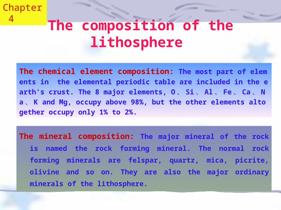
The composition of the lithosphere
The mineral composition: The major mineral of the rock is
named the rock forming mineral. The normal rock forming
minerals are felspar, quartz, mica, picrite, olivine and so
on. They are also the major ordinary minerals of the
lithosphere.
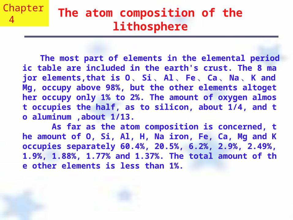
The chemical element composition: The most part of elements in the elemental periodic table are included in the earth's crust. The 8 major elements, O 、 Si 、 Al 、 Fe 、 Ca 、 Na 、 K and Mg, occupy above 98%, but the other elements altogether occupy only 1% to 2%.
Chapter 4
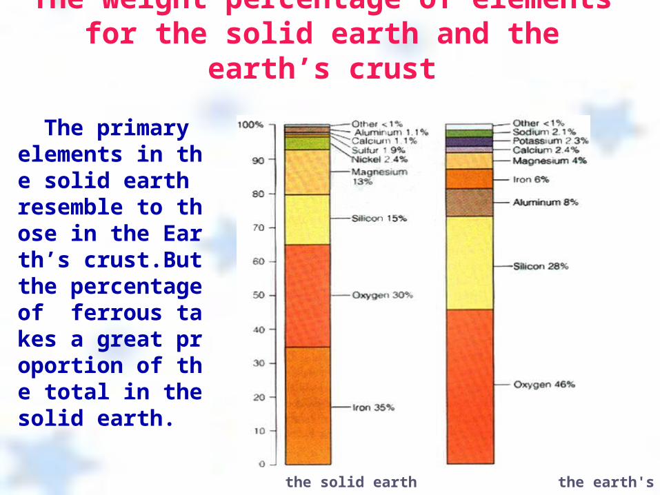
The weight percentage of elements for the solid earth and the earth’s crust
the solid earth the earth's crust
The primary elements in the solid earth resemble to those in the Earth’s crust.But the percentage of ferrous takes a great proportion of the total in the solid earth.
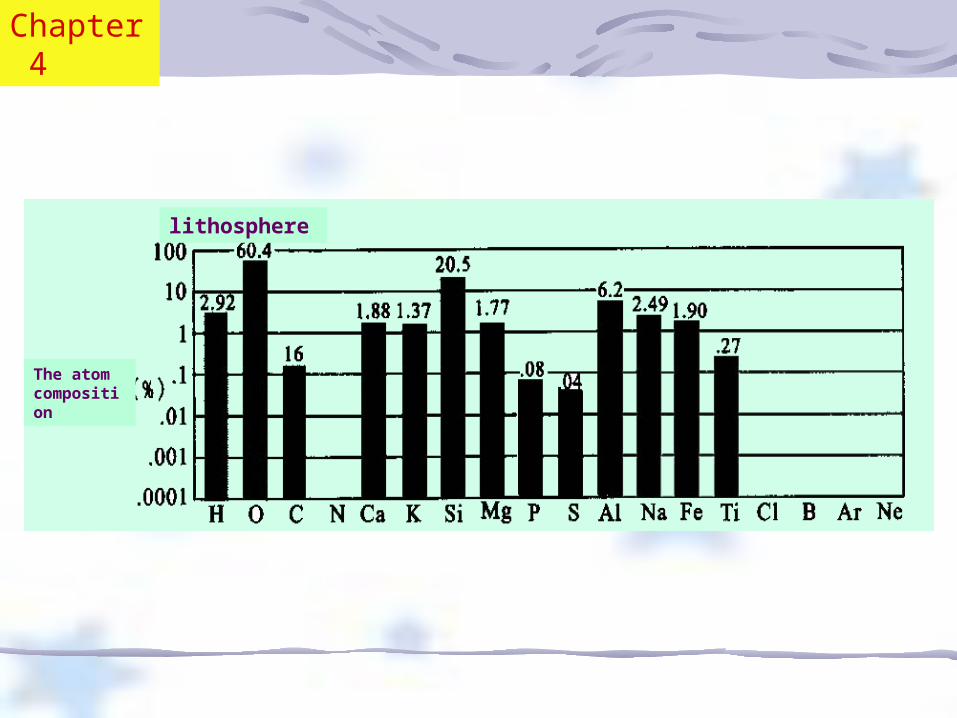
The atom composition of the lithosphere
The most part of elements in the elemental periodic table are included in the earth's crust. The 8 major elements,that is O 、 Si 、Al 、 Fe 、 Ca 、 Na 、 K and Mg, occupy above 98%, but the other elements altogether occupy only 1% to 2%. The amount of oxygen almost occupies the half, as to silicon, about 1/4, and to aluminum ,about 1/13. As far as the atom composition is concerned, the amount of O, Si, Al, H, Na iron, Fe, Ca, Mg and K occupies separately 60.4%, 20.5%, 6.2%, 2.9%, 2.49%,1.9%, 1.88%, 1.77% and 1.37%. The total amount of the other elements is less than 1%.
Chapter 4
lithosphere
The atom composition
Chapter 4
The rock composition of the lithosphere The kinds of the rock: Igneous rock: The magmatic rock is the main part of it. The magmatic rock is formed from the coagulation of the magma and the volume of it accounts for about 65% of the total. It is divided into the acidic rock, intermediate rock, basis rock and ultrabasic rock. It also can be divided into intrusive rock and extrusive one.
Sedimentary rock: The rock exposed on the earth’s surface is weathered and carried. Finally they are formed into sedimentary rock. It is divided into the clastic rock, the clay rock and the biochemistry rock.
Metamorphic rock: The changing process of rock caused by inner force of the earth is called metamorphism. The rock caused by metamorphism is the metamorphic rock. The factors impacting the metamorphism are temperature, the press factor and the chemical factor.
Chapter 4
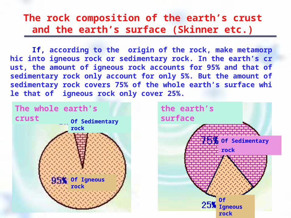
The rock composition of the earth’s crust and the earth’s surface (Skinner etc.)
If, according to the origin of the rock, make metamorphic into igneous rock or sedimentary rock. In the earth’s crust, the amount of igneous rock accounts for 95% and that of sedimentary rock only account for only 5%. But the amount of sedimentary rock covers 75% of the whole earth’s surface while that of igneous rock only cover 25%.
The whole earth's crust the earth’s surface
Of the Of Sedimentary rock
Of Igneous rock
Of Sedimentary
rock
Of Igneous rock
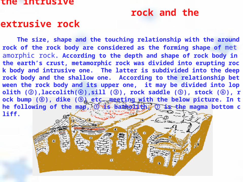
The sketch map of the body of the intrusive rock and the extrusive rock
The size, shape and the touching relationship with the around rock of the rock body are considered as the forming shape of metamorphic rock. According to the depth and shape of rock body in the earth’s crust, metamorphic rock was divided into erupting rock body and intrusive one. The latter is subdivided into the deep rock body and the shallow one. According to the relationship between the rock body and its upper one, it may be divided into lopolith ( ),laccolith( ),sill ( ), rock saddle ( ), stock ( ), rock bump ( ), dike ( ) etc. me② ④ ③ ⑤ ⑥ ⑧ ⑨eting with the below picture. In the following of the map, is batholith, is the magma b① ⑦ottom cliff.
Several kinds of bedding of sedimentary rock
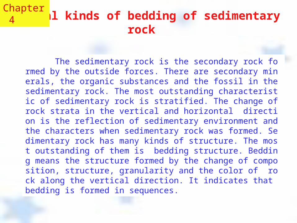
The sedimentary rock is the secondary rock formed by the outside forces. There are secondary minerals, the organic substances and the fossil in the sedimentary rock. The most outstanding characteristic of sedimentary rock is stratified. The change of rock strata in the vertical and horizontal direction is the reflection of sedimentary environment and the characters when sedimentary rock was formed. Sedimentary rock has many kinds of structure. The most outstanding of them is bedding structure. Bedding means the structure formed by the change of composition, structure, granularity and the color of rock along the vertical direction. It indicates that bedding is formed in sequences.
Chapter 4
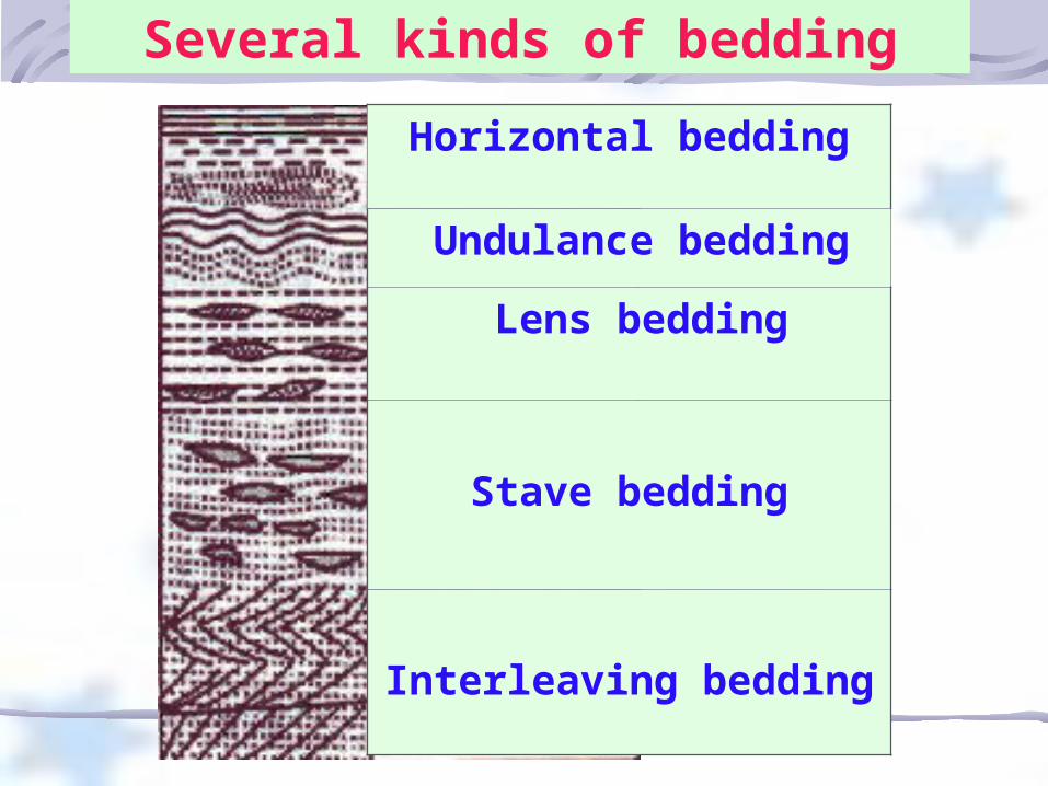
Horizontal bedding
Undulance bedding
Lens bedding
Stave bedding
Interleaving bedding
Several kinds of bedding
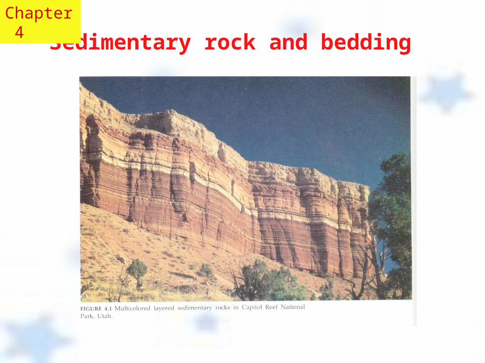
Sedimentary rock and bedding
Chapter 4
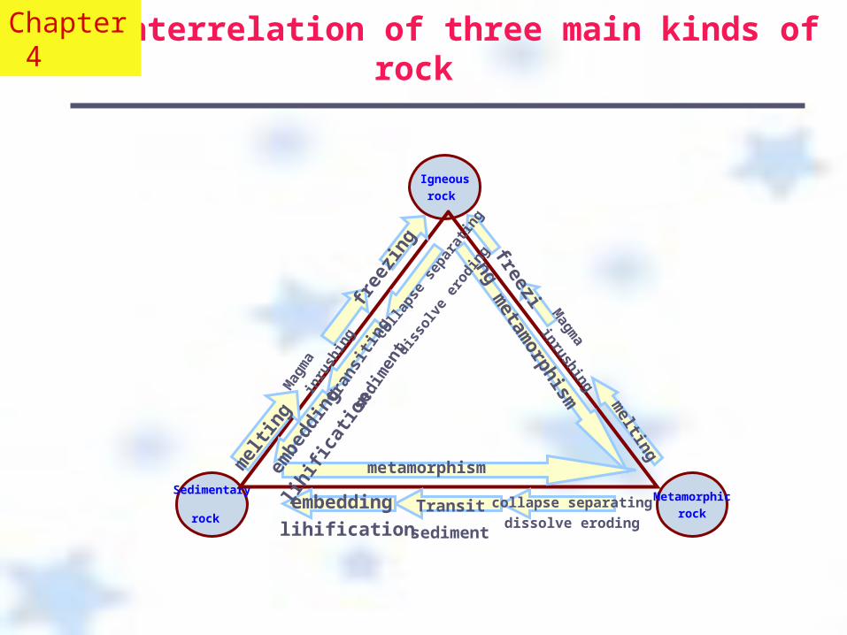
Igneous
rock
Metamorphic
rock
Sedimentary
rock
mel
ting
embe
ddin
g
lihifi
catio
n tr
ansi
ting
sedi
men
t co
llaps
e sep
arat
ing
diss
olve
erod
ing
metam
orphism
melting
freezing
Magm
a
inrushing
metamorphism
embedding
lihificationTransit
sediment
collapse separating
dissolve eroding
free
zing
Mag
ma
inru
shin
g
The interrelation of three main kinds of rock
Chapter 4
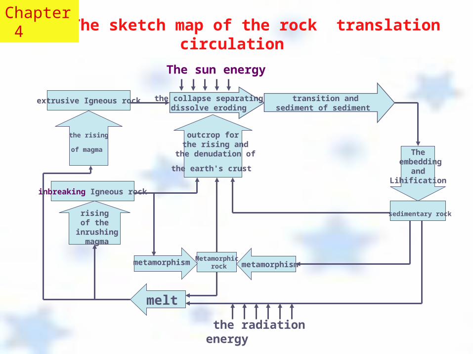
The sketch map of the rock translation circulation
the collapse separating dissolve eroding
transition andsediment of sediment
extrusive Igneous rock
The embedding
and Lihification
sedimentary rock
metamorphism
Metamorphic rock
metamorphism
melt
rising of the
inrushing magma
inbreaking Igneous rock
the rising
of magma outcrop for
the rising and the denudation of
the earth's crust
the radiation energy
The sun energy
Chapter 4
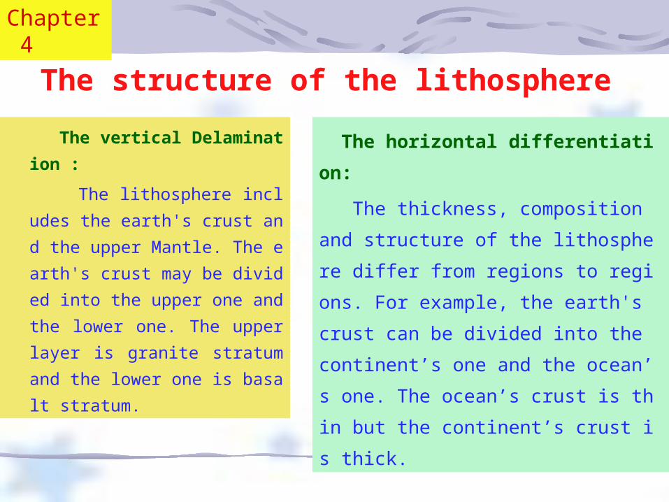
The structure of the lithosphere
The vertical Delamination : The lithosphere includes the eart
h's crust and the upper Mantle. T
he earth's crust may be divided in
to the upper one and the lower on
e. The upper layer is granite strat
um and the lower one is basalt str
atum.
The horizontal differentiation:
The thickness, composition and structure of
the lithosphere differ from regions to regions.
For example, the earth's crust can be divided i
nto the continent’s one and the ocean’s one. T
he ocean’s crust is thin but the continent’s cru
st is thick.
Chapter 4
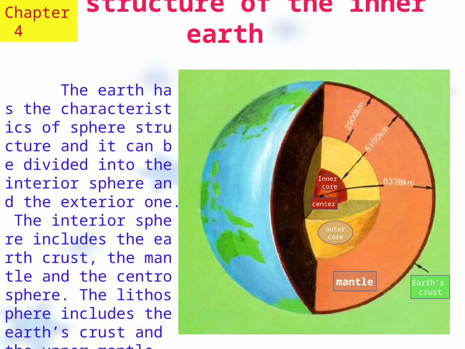
The earth has the characteristics of sphere structure and it can be divided into the interior sphere and the exterior one. The interior sphere includes the earth crust, the mantle and the centrosphere. The lithosphere includes the earth’s crust and the upper mantle.
The structure of the inner earth
Inner core
outer core
mantle Earth’s crust
center
Chapter 4
The layers of the earth
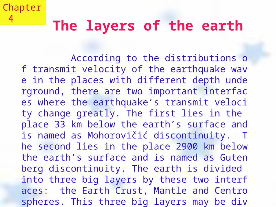
According to the distributions of transmit velocity of the earthquake wave in the places with different depth underground, there are two important interfaces where the earthquake’s transmit velocity change greatly. The first lies in the place 33 km below the earth’s surface and is named as Mohorovičić discontinuity. The second lies in the place 2900 km below the earth’s surface and is named as Gutenberg discontinuity. The earth is divided into three big layers by these two interfaces: the Earth Crust, Mantle and Centrospheres. This three big layers may be divided into seven layers.
Chapter 4
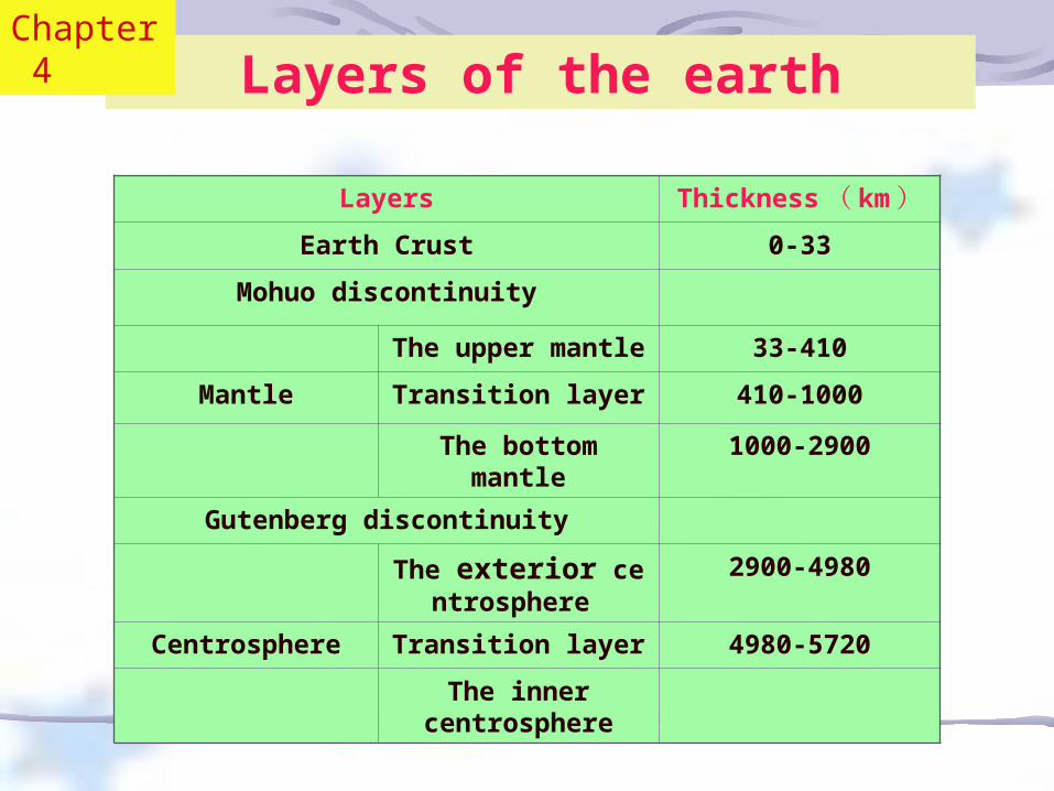
Layers Thickness ( km)
Earth Crust 0-33Mohuo discontinuity
The upper mantle
33-410
Mantle Transition layer 410-1000The bottom
mantle1000-2900
Gutenberg discontinuity
The exterior centrosphere
2900-4980
Centrosphere Transition layer 4980-5720The inner
centrosphere
Layers of the earthChapter 4
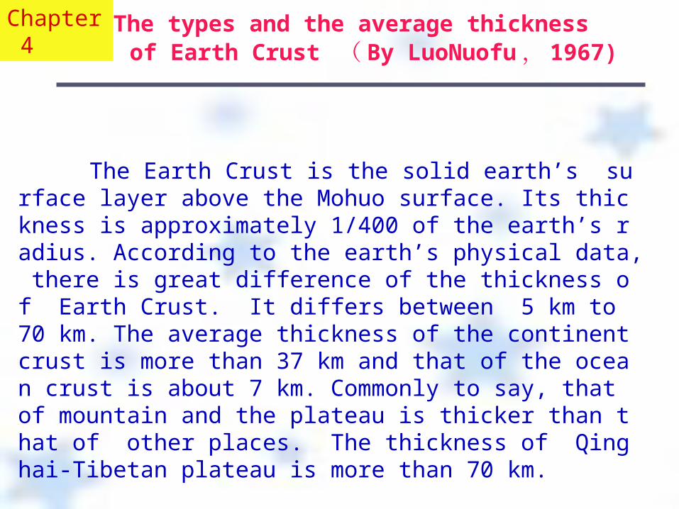
The types and the average thickness of Earth Crust ( By LuoNuofu , 1967)
The Earth Crust is the solid earth’s surface layer above the Mohuo surface. Its thickness is approximately 1/400 of the earth’s radius. According to the earth’s physical data, there is great difference of the thickness of Earth Crust. It differs between 5 km to 70 km. The average thickness of the continent crust is more than 37 km and that of the ocean crust is about 7 km. Commonly to say, that of mountain and the plateau is thicker than that of other places. The thickness of Qinghai-Tibetan plateau is more than 70 km.
Chapter 4
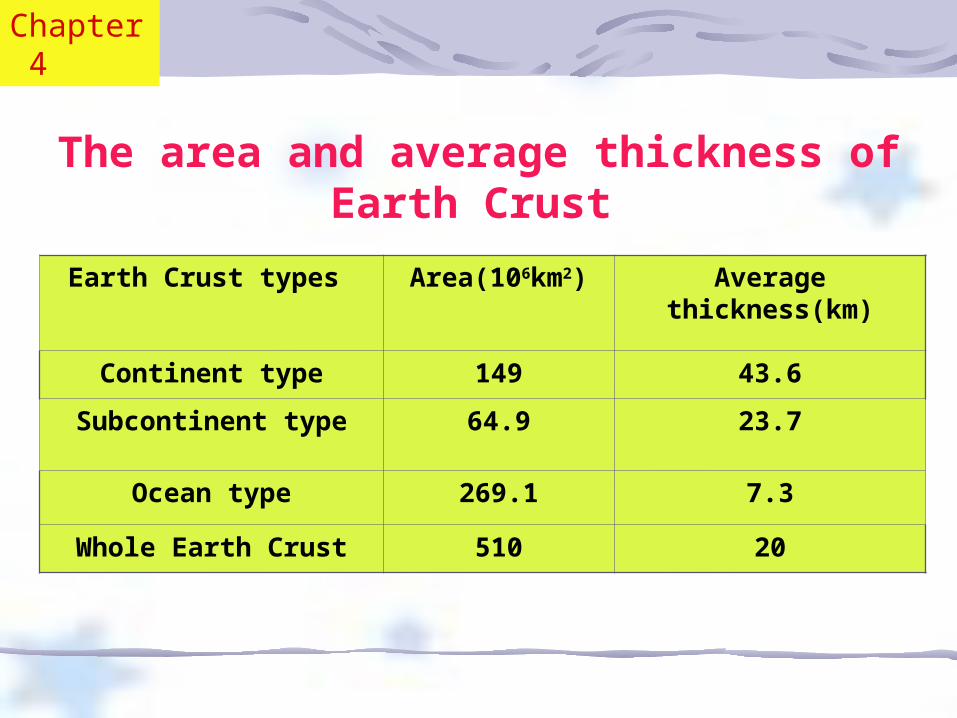
Earth Crust types Area(106km2) Average thickness(km)
Continent type 149 43.6Subcontinent type 64.9 23.7
Ocean type 269.1 7.3
Whole Earth Crust 510 20
The area and average thickness of Earth Crust
Chapter 4
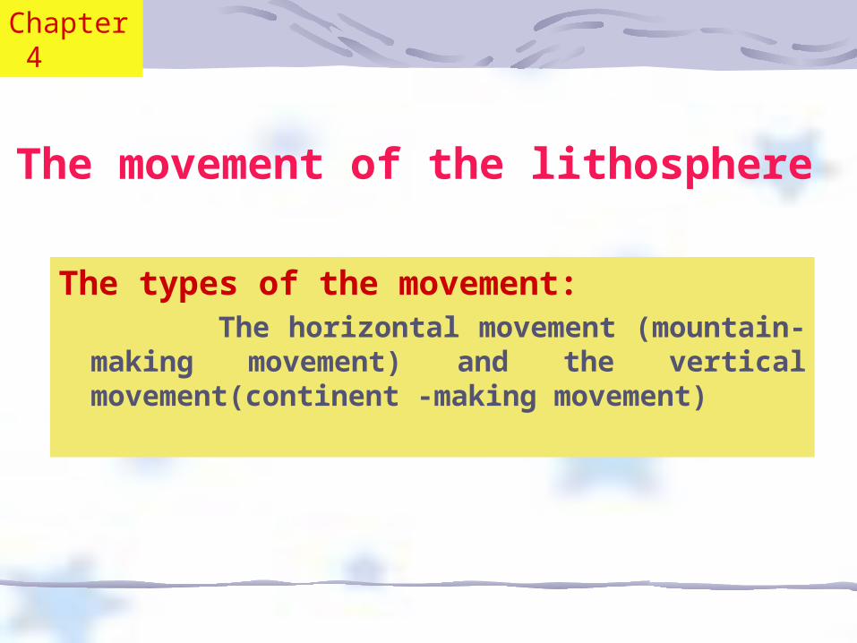
The movement of the lithosphere
The types of the movement: The horizontal movement (mountain-
making movement) and the vertical movement(continent -making movement)
Chapter 4
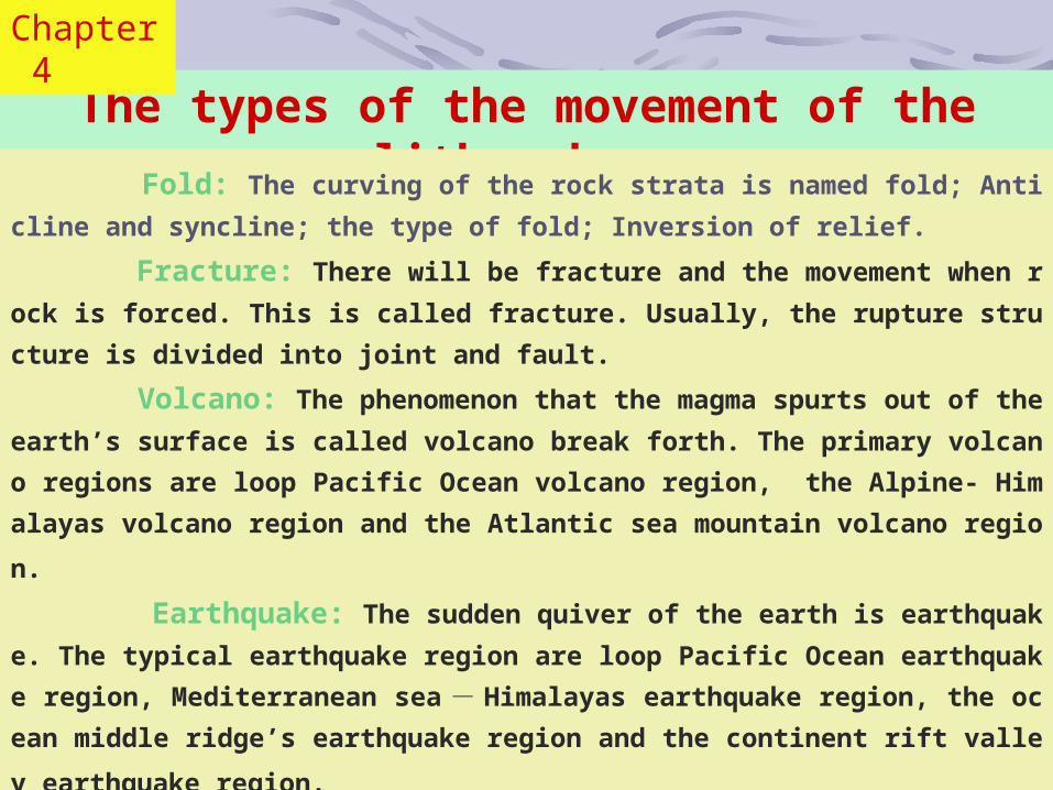
The types of the movement of the lithosphere
Fold: The curving of the rock strata is named fold; Anticline and syncline; the type of
fold; Inversion of relief.
Fracture: There will be fracture and the movement when rock is forced. This is called
fracture. Usually, the rupture structure is divided into joint and fault.
Volcano: The phenomenon that the magma spurts out of the earth’s surface is called v
olcano break forth. The primary volcano regions are loop Pacific Ocean volcano region, th
e Alpine- Himalayas volcano region and the Atlantic sea mountain volcano region.
Earthquake: The sudden quiver of the earth is earthquake. The typical earthquake r
egion are loop Pacific Ocean earthquake region, Mediterranean sea - Himalayas earthqua
ke region, the ocean middle ridge’s earthquake region and the continent rift valley earthqu
ake region.
Chapter 4
The movement of the lithosphere
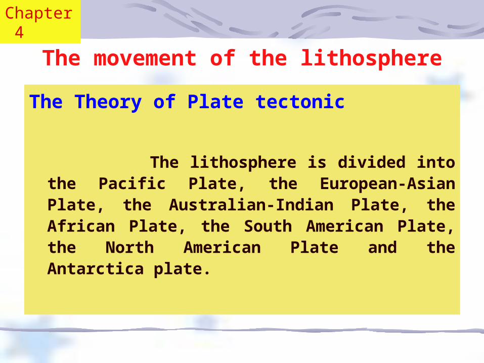
The Theory of Plate tectonic
The lithosphere is divided into the Pacific Plate, the
European-Asian Plate, the Australian-Indian Plate, the African Plate, the South American Plate, the North American Plate and the Antarctica plate.
Chapter 4
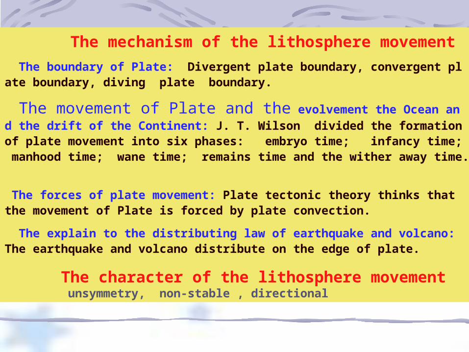
The mechanism of the lithosphere movement The boundary of Plate: Divergent plate boundary, convergent plate boundary, diving plate boundary.
The movement of Plate and the evolvement the Ocean and the drift of the Continent: J. T. Wilson divided the formation of plate movement into six phases: embryo time; infancy time; manhood time; wane time; remains time and the wither away time.
The forces of plate movement: Plate tectonic theory thinks that the movement of Plate is forced by plate convection.
The explain to the distributing law of earthquake and volcano: The earthquake and volcano distribute on the edge of plate.
The character of the lithosphere movement unsymmetry, non-stable , directional
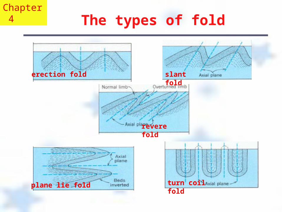
The types of fold
erection fold slant fold
revere fold
plane lie fold turn coil fold
Chapter 4
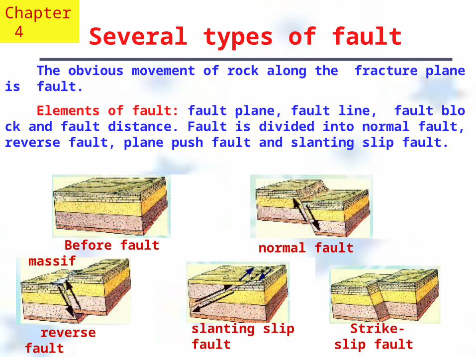
Several types of fault The obvious movement of rock along the fracture plane is fault.
Elements of fault: fault plane, fault line, fault block and fault distance. Fault is divided into normal fault, reverse fault, plane push fault and slanting slip fault.
Chapter 4
reverse fault slanting slip fault Strike-slip fault
Before fault massif normal fault
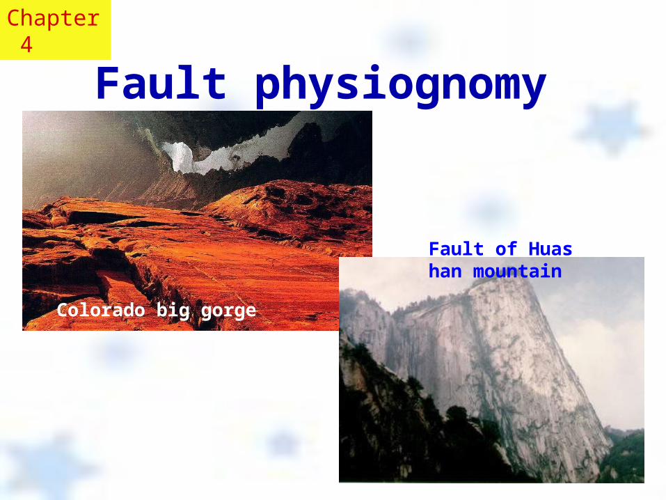
Fault physiognomy
Colorado big gorge
Fault of Huashan mountain
Chapter 4
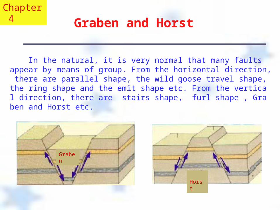
Graben and Horst In the natural, it is very normal that many faults appear by means of group. From the horizontal direction, there are parallel shape, the wild goose travel shape, the ring shape and the emit shape etc. From the vertical direction, there are stairs shape, furl shape , Graben and Horst etc.
Graben
Horst
Chapter 4
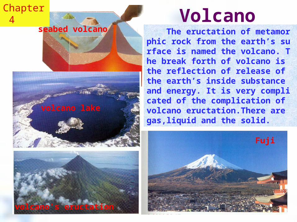
Volcano
Fuji
The eructation of metamorphic rock from the earth’s surface is named the volcano. The break forth of volcano is the reflection of release of the earth’s inside substance and energy. It is very complicated of the complication of volcano eructation.There are gas,liquid and the solid.
volcano’s eructation
seabed volcano
volcano lake
Chapter 4
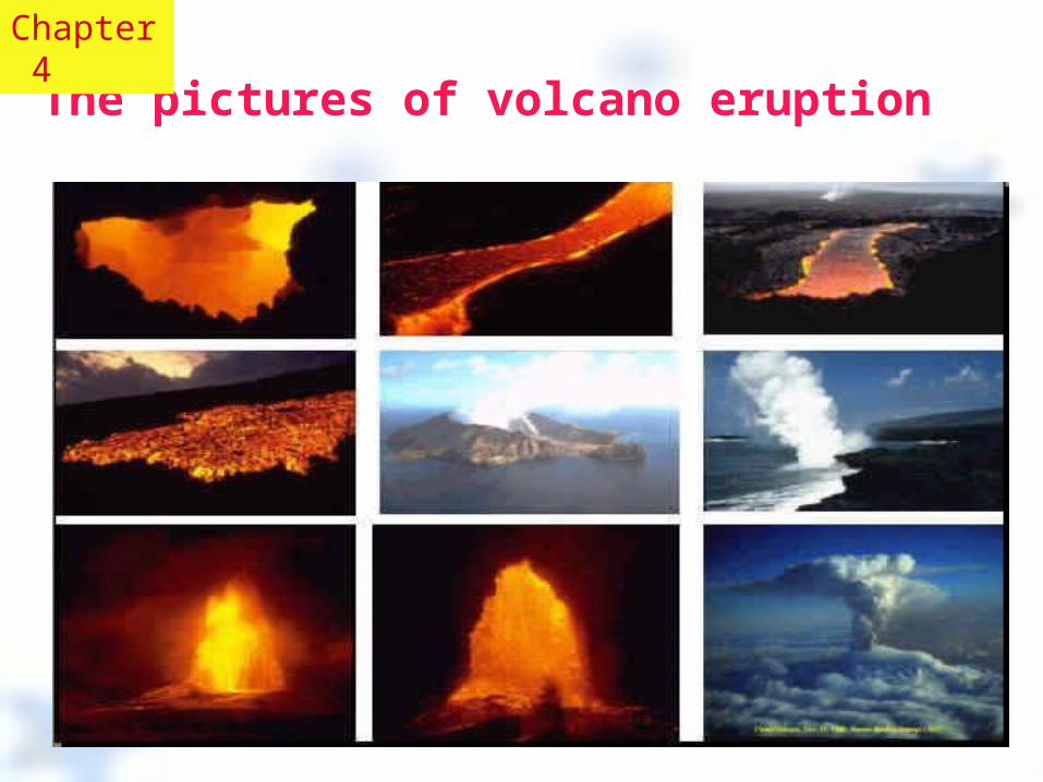
The pictures of volcano eruption
Chapter 4

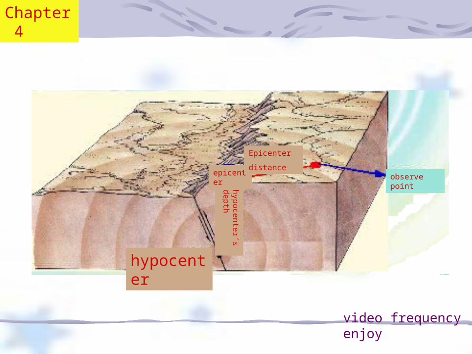
The epicenter, epicenter’s distance, hypocenter’s depth and the hypocenter
The places underground where there is earthquake is the hypocenter. Its vertical projection on the earth’s surface is epicenter. The distance from the epicenter to the hypocenter is the hypocenter’s depth. According to the depth, the earthquake is divided into the shallow hypocenter earthquake (the hypocenter’s depth is less than 70km), the middle hypocenter earthquake (the hypocenter’s depth is 70-300km) and the deep hypocenter earthquake (the hypocenter’s depth is more than 300km). Most earthquakes belong to the shallow hypocenter earthquake.The number of them occupies about 72.5% of the total and the amount of energy they release occupies 85%. The number of the deep hypocenter earthquake only occupies 4% and the amount of energy they release occupies about 3%. Although some of the level of the middle hypocenter earthquake is very high, it does little harm. The distance from the observation point (such as the earthquake station) to the epicenter is named the epicenter’s distance. Usually, the earthquake which epicenter’s distance is less than 100 km is named local earthquake. The earthquake which epicenter’s distance is between 100 km and 1000 km is near earthquake and if the epicenter’s distance is more than 1000 km, far earthquake.
Chapter 4
video frequency enjoy
hypocenter
epicenter
hypocenter’s depth
Epicenter
distance observe point
Chapter 4
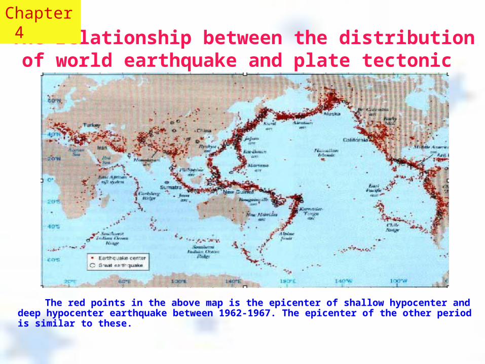
The relationship between the distribution of world earthquake and plate tectonic
The red points in the above map is the epicenter of shallow hypocenter and deep hypocenter earthquake between 1962-1967. The epicenter of the other period is similar to these.
Chapter 4
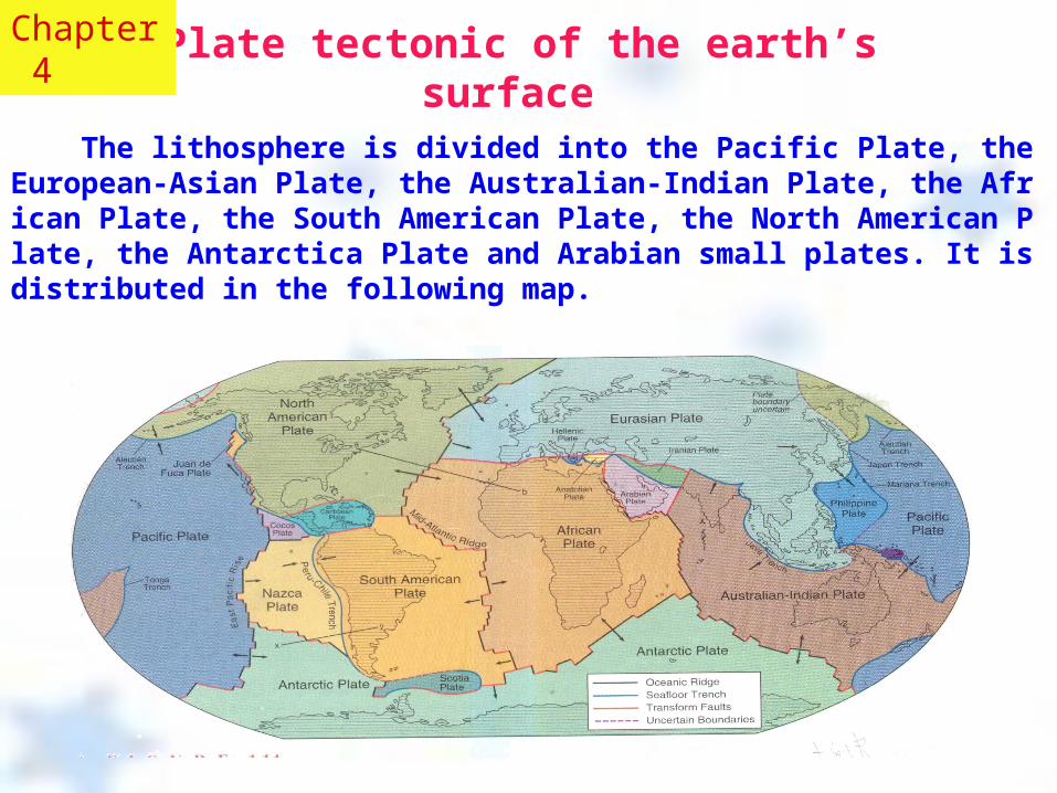
Plate tectonic of the earth’s surface
The lithosphere is divided into the Pacific Plate, the European-Asian Plate, the Australian-Indian Plate, the African Plate, the South American Plate, the North American Plate, the Antarctica Plate and Arabian small plates. It is distributed in the following map.
Chapter 4
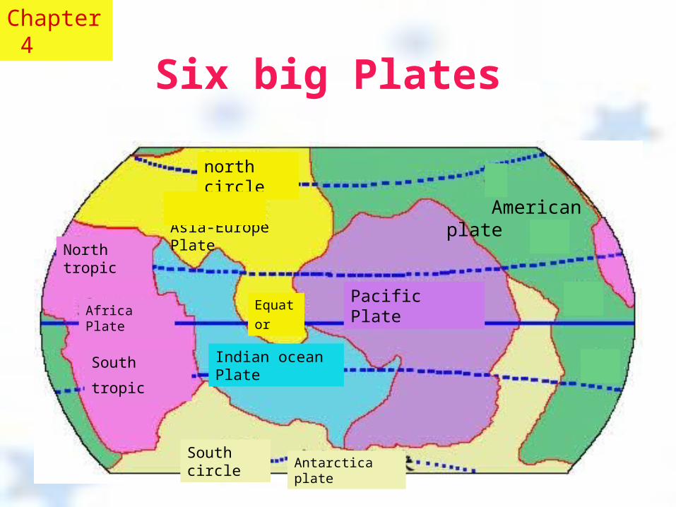
Six big Plates
north circle
Asia-Europe Plate
Pacific Plate Africa Plate Equator
North tropic
South tropic Indian ocean Plate
American plate
South circleAntarctica plate
Chapter 4
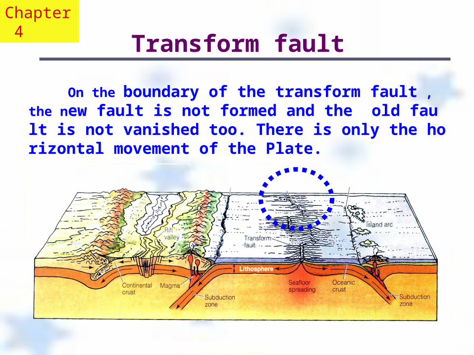
Transform fault
On the boundary of the transform fault , the new fault is not formed and the old fault is not vanished too. There is only the horizontal movement of the Plate.
Chapter 4
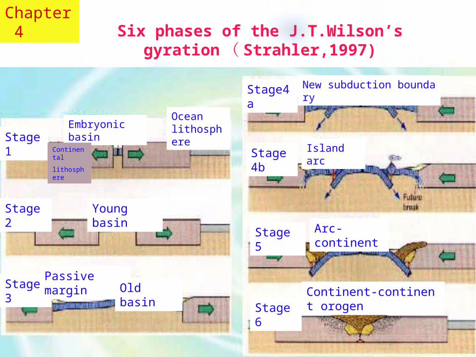
Six phases of the J.T.Wilson’s gyration ( Strahler,1997)
Chapter 4
Stage 1Embryonic basin
Ocean lithosphere
Stage 2 Young basin
Stage 3Passive margin
Old basin
Stage4a New subduction boundary
Stage4b Island arc
Stage 5 Arc-continent
Stage 6Continent-continent orogen
Continental
lithosphere
The convection of Mantle and the movement of Plates ( Strahler)
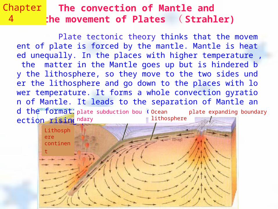
Plate tectonic theory thinks that the movement of plate is forced by the mantle. Mantle is heated unequally. In the places with higher temperature , the matter in the Mantle goes up but is hindered by the lithosphere, so they move to the two sides under the lithosphere and go down to the places with lower temperature. It forms a whole convection gyration of Mantle. It leads to the separation of Mantle and the formation of the new ocean’s crust on the convection rising place.
Chapter 4
Lithosphere
continent
plate subduction boundary Ocean lithosphere plate expanding boundary
The structure and the outline of the solid
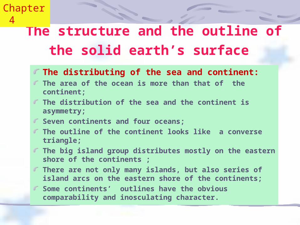
earth’s surface The distributing of the sea and continent:The area of the ocean is more than that of the continent;
The distribution of the sea and the continent is asymmetry;
Seven continents and four oceans;
The outline of the continent looks like a converse triangle;
The big island group distributes mostly on the eastern shore of the continents ;
There are not only many islands, but also series of island arcs on the eastern shore of the continents;
Some continents’ outlines have the obvious comparability and inosculating character.
Chapter 4
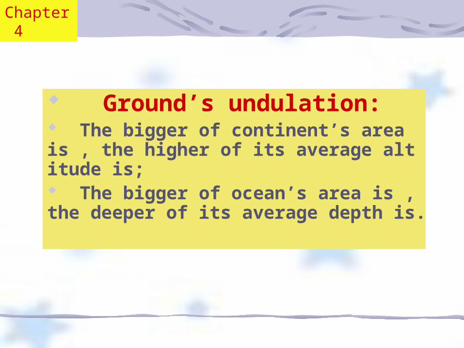
Ground’s undulation: The bigger of continent’s area is , the higher of its average altitude is; The bigger of ocean’s area is , the deeper of its average depth is.
Chapter 4
The distribution of the oceans
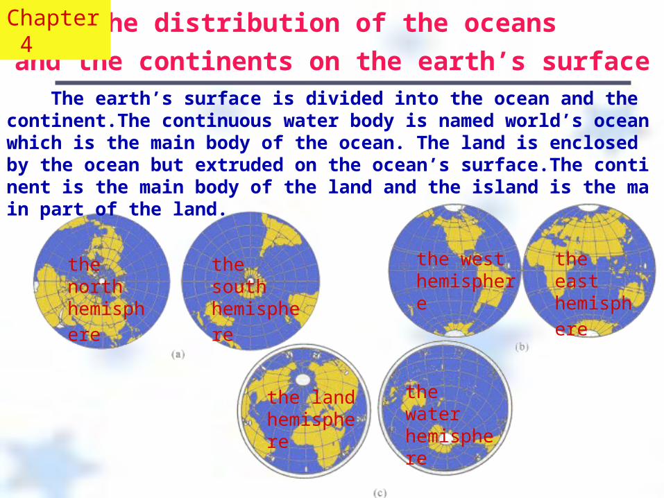
and the continents on the earth’s surface The earth’s surface is divided into the ocean and the continent.The continuous water body is named world’s ocean which is the main body of the ocean. The land is enclosed by the ocean but extruded on the ocean’s surface.The continent is the main body of the land and the island is the main part of the land.
Chapter 4
the south
hemisphere the north
hemisphere
the east
hemisphere the west hemisphere
the water hemisphere
the land hemisphere

The comparison of the ocean’s area and
land’s area of two hemispheres
Land hemisphere
East hemisphere West hemisphere North hemisphere
South hemisphere
Water hemisphere
38.062.0
39.360.720.0
Land (%)Ocean(%)80.0
80.9 19.189.0 11.053.0 47.0
The earth’s surface includes land and ocean. Because the area of the sea and that of continent differ a lot, the sea’s area is more than the land’s area and the distribution is not uniformity. It is obvious that the land’s area of the eastern hemisphere(38 % ) is more than western one(20%) and the land’s area of the north hemisphere(39.3 % ) is more than that of south one(19.1%). The land’s area of land hemisphere is 47%, but the ocean's area of water hemisphere is 89% 。
Chapter 4
There are great differences between the average height of every continent above the sea level and the average depth of ocean’s bottom under the sea level. The average height of the Antarctica is 2263m and it is always regarded as the highest continent in the world. It is caused by the huge thick icecap on its cover. As far as the earth’s surface is concerned, the height of Asia is the tallest one (950m), then the north America (700m), the Africa(650m), the south America(600m)and the Europe(300m). Obviously, the more the continent’s area is, the taller its altitude is. It is also true that the more the ocean’s area is, the deeper its average depth is.
The relationship between Continent’s area and the average height
Chapter 4
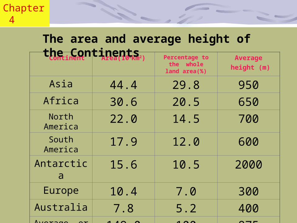
Continent Area(106km2) Percentage to the whole
land area(%)
Average height (m)
Asia 44.4 29.8 950Africa 30.6 20.5 650North
America22.0 14.5 700
South America
17.9 12.0 600
Antarctica 15.6 10.5 2000Europe 10.4 7.0 300
Australia 7.8 5.2 400Average or
sum149.0 100 875
The area and average height of the Continents
Chapter 4
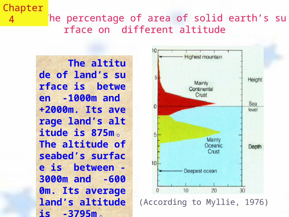
The altitude of land’s surface is between -1000m and +2000m. Its average land’s altitude is 875m 。 The altitude of seabed’s surface is between - 3000m and -6000m. Its average land’s altitude is -3795m 。
The percentage of area of solid earth’s surface on different altitude
(According to Myllie, 1976)
Chapter 4
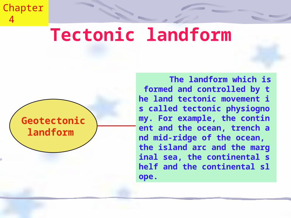
Tectonic landform
The landform which is formed and controlled by the land tectonic movement is called tectonic physiognomy. For example, the continent and the ocean, trench and mid-ridge of the ocean, the island arc and the marginal sea, the continental shelf and the continental slope.
Geotectoniclandform
Chapter 4
Regionaltectonic
landform
It is formed on the basis of the geotectonic landform. But it has regional character. The typical representations are the plateau, the plain, the basin, the volcano of the sea’s bottom and so on.
Chapter 4
Local tectonic
landform
It is formed on the basis of the geotectonic landform and regional tectonic landform. But it is impacted by local tectonic action. It’s divided into fold landform, fault landform, volcano landform, lithology tectonic landform and so on.
Chapter 4
Monoclinal landform
There are two types of monoclinal landform: cuesta (monoclinal hill ) and the pig back ridge(pig back hill). When the rock strata’s dip angle is very small, the dip angle of hillside developing in the same direction of terrane is small too. But that of the other hillside is comparative precipitous. So the two hillsides are dissymmetrical. This kind of hill is named the Monoclinal hill.
Chapter 4
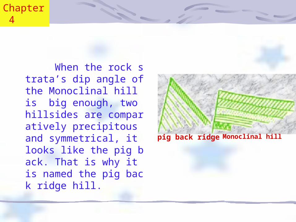
When the rock strata’s dip angle of the Monoclinal hill is big enough, two hillsides are comparatively precipitous and symmetrical, it looks like the pig back. That is why it is named the pig back ridge hill. Monoclinal hill pig back ridge
Chapter 4
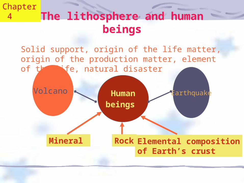
The lithosphere and human beings
Humanbeings
Rock Mineral Elemental compositionof Earth’s crust
Volcano Earthquake
Solid support, origin of the life matter, origin of the production matter, element of the life, natural disaster
Chapter 4


