CHAPTER 5 | AIRPORT DEVELOPMENT ALTERNATIVES | JULY 2017 | 1 EPHRATA MUNICIPAL AIRPORT AIRPORT MASTER PLAN Chapter 5 – Airport Development Alternatives The evaluation of future development alternatives represents a critical step in the airport master planning process. The primary goal is to define a path for future development that provides an efficient use of resources and is capable of accommodating the forecast demand and facility needs defined in the master plan. Introduction Current and long-term planning for Ephrata Municipal Airport is based on maintaining and improving the airport’s ability to serve a wide range of general aviation and business aviation aircraft, as noted in the facility requirements evaluation. All proposed facility improvements are consistent with applicable FAA airport design standards and FAR Part 77 airspace planning standards. As noted in the facility requirements chapter: • Airplane Design Group II (ADG II) standards are recommended for facilities used by both large and small aircraft, including Runways 3/21 and 4/22, major taxiways, and specific landside facilities; o It is noted that gliders, which operate predominantly on Runway 4/22, present a unique set of design features. The aircraft have long wingspans (typically ADG II or larger) but their low operating weights classify them as small aircraft. o This justifies use of ADG II (small) standards for Runway 4/22, whereas Runway 3/21 requires use of the full ADG II standards for approach category A and B aircraft.
Transcript
CHAPTER 5 | AIRPORT DEVELOPMENT ALTERNATIVES | JULY 2017 | 1
EPHRATA MUNICIPAL AIRPORT AIRPORT MASTER PLAN
Chapter 5 – Airport Development Alternatives
The evaluation of future development alternatives represents a critical step in the airport master planning process. The primary goal is to define a path for future development that provides an efficient use of resources and is capable of accommodating the forecast demand and facility needs defined in the master plan.
Introduction
Current and long-term planning for Ephrata Municipal Airport is based on maintaining and improving the
airport’s ability to serve a wide range of general aviation and business aviation aircraft, as noted in the
facility requirements evaluation.
All proposed facility improvements are consistent with applicable FAA airport design standards and FAR
Part 77 airspace planning standards. As noted in the facility requirements chapter:
• Airplane Design Group II (ADG II) standards are recommended for facilities used by both large
and small aircraft, including Runways 3/21 and 4/22, major taxiways, and specific landside
facilities;
o It is noted that gliders, which operate predominantly on Runway 4/22, present a unique
set of design features. The aircraft have long wingspans (typically ADG II or larger) but
their low operating weights classify them as small aircraft.
o This justifies use of ADG II (small) standards for Runway 4/22, whereas Runway 3/21
requires use of the full ADG II standards for approach category A and B aircraft.
CHAPTER 5 | AIRPORT DEVELOPMENT ALTERNATIVES | JULY 2017 | 2
EPHRATA MUNICIPAL AIRPORT AIRPORT MASTER PLAN
• Facilities that accommodate small aircraft exclusively, such as Runway 11/29, T-hangar taxilanes
and aircraft tiedown aprons, are normally designed to meet ADG I (small aircraft with wingspans
less than 49 feet) standards.
• For hangar areas with a variety of hangar sizes, the largest hangar door width anticipated is generally
used to identify the maximum size of aircraft to be accommodated and the appropriate ADG.
The FAA recommends that airport master plans be developed in an “unconstrained” manner when initially
defining future demand and related facility improvements, rather than establishing pre-defined limits that
drive the planning process. The evaluation of development options for Ephrata Municipal Airport will be
unconstrained, consistent with FAA guidance, forecast demand, and the defined facility requirements.
Evaluation Process
Developing preliminary alternatives represents the first step in a multi-step process that leads to the selection
of a preferred alternative. It is important to note that the current FAA-approved airport layout plan (ALP)
dated June 2010, identifies future improvements that were defined in the last master planning process. This
master plan update provides a fresh look at addressing facility needs, but also allows the components of the
previous preferred alternative to be retained or modified, if they meet current or future needs.
The preliminary alternatives will be evaluated to identify general preferences for both individual items and
the overall concepts. This process will provide the widest range of ideas for consideration and define the
most effective facility development concept. A preferred alternative will emerge from this evaluation
process with elements that can best accommodate all required facility improvements. The Consultant will
integrate these elements into a draft preferred alternative for review and refinement as the Port of Ephrata
proceeds through the process of selecting a final preferred development alternative for Ephrata Municipal
Airport. Public input and coordination with the FAA and WSDOT Aviation will also help shape the
preferred alternative throughout this process.
Once the preferred alternative is selected by the Port of Ephrata, a detailed capital improvement program will
be created that identifies and prioritizes specific projects to be implemented. The preferred alternative will be
integrated into the updated airport layout plan (ALP) drawings to guide future improvements at the airport.
No-Action Alternative
In addition to proactive options designed to respond to future facility needs, a “no-action” alternative also
exists. The Port of Ephrata may choose to maintain existing facilities and capabilities without investing in
facility upgrades or expansion to address future demand. The existing airfield would remain unchanged
from its present configuration and the airport would essentially be operated in a “maintenance-only” mode.
Reconfiguration of facilities to address non-standard items is not consistent with a “maintenance-only”
option, although the requirement to observe clearing standards (RSA, OFA, etc.) for existing facilities is
established.
CHAPTER 5 | AIRPORT DEVELOPMENT ALTERNATIVES | JULY 2017 | 3
EPHRATA MUNICIPAL AIRPORT AIRPORT MASTER PLAN
The no-action alternative would limit the airport’s ability to meet all applicable FAA design standards or
accommodate aviation demand beyond current facility capabilities. Future aviation activity levels would
be constrained by the capacity, safety, and operational limits of the existing airport facilities.
The no-action alternative establishes a baseline from which the other alternatives will be developed and
compared. The purpose and need for proactive development alternatives (e.g., airport improvements) is
defined by desired compliance with FAA design standards and forecast aviation activity and the
corresponding facility needs for the current twenty-year planning period as identified in Chapters 3 and 4
of this study. Proposed improvements are based on safety considerations and the responsibility to
effectively manage demand through a well-defined and economical program.
Preliminary Development Alternatives
The facility needs identified in Chapter 4 include a variety of airside (runway-taxiway) and landside needs
(aircraft parking, hangars, fueling, FBO facilities, etc.). Items such as fencing, lighting improvements, minor
roadway extensions, and pavement maintenance do not typically require an alternatives analysis. However,
these items will be incorporated into the preferred development alternative and the updated ALP.
The preliminary alternatives are organized by type of facilities (airside and landside) and are intended to
facilitate a discussion and evaluation about the most efficient way to meet the facility needs of the airport. The
eventual preferred alternative selected by the Port of Ephrata may come from one of the preliminary alternatives,
a combination or hybrid of the preliminary alternatives, or a new concept that evolves through the evaluation
and discussion of the preliminary alternatives. As noted earlier, the Port of Ephrata also has the option of
limiting future facility improvements based on financial considerations or development limitations.
The preliminary development alternatives are described below with graphic depictions (Figures 5-1
through 5-7) provided to illustrate the key elements of each alternative.
AIRSIDE DEVELOPMENT ALTERNATIVES (RUNWAY-TAXIWAY IMPROVEMENTS)
As noted in the facility requirements chapter, the airport’s primary runway and parallel taxiway, and the
crosswind runway and its parallel taxiway were rehabilitated, reconstructed, or constructed new since the
last master plan was completed. These airside facilities do not require upgrades at this time, as they meet
current and future needs, and conform to FAA standards.
CHAPTER 5 | AIRPORT DEVELOPMENT ALTERNATIVES | JULY 2017 | 4
EPHRATA MUNICIPAL AIRPORT AIRPORT MASTER PLAN
AIRSIDE IMPROVEMENTS – OVERVIEW (FIGURE 5-1)
Figure 5-1 provides an overview of recommended airside improvements, which include the following:
Runway Protection Zone (RPZ) - Runway 3. The recommended RPZ (500 x 700 x 1000 feet) is based
on approach visibility minimums of 1-mile or greater. This recommendation eliminates the previous master
plan recommendation to plan for approach visibilities as low as ½-mile, which required a significantly
larger RPZ and FAR Part 77 precision instrument approach surface. This recommendation also eliminates
issues related to a future FAA-defined incompatible land uses (Airport Street crossing through the larger
RPZ), and it supports the existing non-precision instrument approach for Runway 3.
No changes are required to the existing non-precision instrument (NPI) markings for Runway 3. The
previous recommendations adding runway approach lighting system (MALS-R) on Runway 3 and
upgrading runway end markings to precision instrument (PIR) are not maintained.
Runway 11/29: No changes recommended.
Taxiway B (Runway 11/29 Parallel Taxiway): Update markings for Runway 29 aircraft hold area to
identify parallel taxiway object free area setback (65.5 feet from taxiway centerline).
Runway 4/22: ADG II (small) standards recommended for runway. Reconfiguration of adjacent aircraft
apron required to meet FAA OFA clearing standard for parked aircraft. Replacement of existing apron
taxilane with full-length parallel taxiway on west side of Runway 4/22 is recommended. The proposed
improvements for Runway 4/22 are described in more detail in the following section.
AIRSIDE IMPROVEMENTS (OVERVIEW) FIGURE (5-1)
400' 800'0'
Scale: 1"=400'
N
TRUEMAG.
DRAFT
AEROBATIC BOX(APPROX. 3,200' X 3,200')
AEROBATIC BOX(APPROX. 3,200' X 3,200')
RUN
WAY 11-29 3,843 X 60'
RUN
WAY 11-29 3,843 X 60'
RUNWAY 3-21 5,500 X 75'RUNWAY 3-21 5,500 X 75'
RUNWAY 4-22 3,467 X 150'RUNWAY 4-22 3,467 X 150'
AIRPORT STREET
AIRPORT STREET
RUNWAY 4EL. 1261.36'
RUNWAY 22EL. 1263.67'
RUNWAY 3EL. 1261.46'
RUNWAY 21EL. 1275.62'
RUNWAY 29EL. 1257.67'
RUNWAY 11EL. 1261.30'
EPHRATA AIRPORT
SEE FIGURE 5-7
SEE FIGURES 5-4, 5-5,AND 5-6
NO
N-AERO
NAU
TICAL
LAND U
SE (110 ACRES +/-)N
ON
-AERON
AUTICAL
LAND U
SE (110 ACRES +/-)
AVIATION
RELATED DEVELOPM
ENT
RESERVE (115 ACRES +/-)AVIATIO
N RELATED DEVELO
PMEN
T
RESERVE (115 ACRES +/-)
HIGHWAY 282
HIGHWAY 282 SEE FIGURES 5-2 AND 5-3
RUNWAY 3RECOMMENDED RPZ(1 MILE ≥ VISIBILITY)
EPHRATA MUNICIPAL AIRPORTAIRPORT MASTER PLAN
AIRSIDE IMPROVEMENT (OVERVIEW)FIGURE 5-1
CHAPTER 5 | AIRPORT DEVELOPMENT ALTERNATIVES | JULY 2017 | 6
EPHRATA MUNICIPAL AIRPORT AIRPORT MASTER PLAN
AIRSIDE ALTERNATIVES A AND B (RUNWAY 4/22) (FIGURE 5-2, 5-3)
As noted in the facility requirements chapter, Runway 4/22 will require pavement rehabilitation early in
the current 20-year planning period. Several improvements or changes in configuration are proposed for
Runway 4/22 to meet FAA design standards for the current and future design aircraft (ADG II – wingspans
up to 79 feet).
In addition to the overall improvements to the runway described below, two options (Alternatives A and
B) were developed for Runway 4/22 that focus on the Runway 4 threshold and taxiway connection
configurations (see Figures 5-2 and 5-3).
Runway Width
Maintaining the existing 150-foot width for Runway 4/22 is recommended based on current design aircraft
(ADG II gliders) and previous design guidance coordinated with FAA.1 Airport management has indicated
a desire to maintain the existing runway width if feasible, due to its use by ADG III gliders with wingspans
approaching 100 feet. The existing runway is situated within the overall paved apron area. It is assumed
that the rehabilitated runway (at any particular width) will be surrounded by apron pavement, which also
functions as runway safety area.
It is recognized that the recommended runway width exceeds the FAA standard for ADG II (75 feet) and
that the additional 75 feet may not be fully eligible for FAA funding. Project eligibility would be determined
during design, including costs related to providing/preserving standard ADG II runway safety area (RSA)
within the existing paved apron.
As noted above, maintaining a safe operating environment (unobstructed, unbroken pavement) for gliders
is identified as a high safety-related priority. Primary operational concerns for large wingspan gliders with
limited ground clearance include:
• Providing sufficient runway width to accommodate aircraft directional control both while under tow and during landing and rollout;
• Avoiding the presence of objects protruding above the paved surface such as runway lights that could create a hazard for wing clearance for aircraft on the ground; and
• Maintaining adequate runway length for tow airplane/glider combinations.
Although the current and forecast volume of ADG III glider operations are not sufficient for use as the
design aircraft, it is desirable to maintain the existing operating environment (unobstructed, unbroken
pavement) for these aircraft within the main apron. Runway lights are not recommended for Runway 4/22,
1 Taxiway A Relocation and Runway 3-21 Establishment Project Engineer’s Design Report (July 2009, Reid Middleton)
CHAPTER 5 | AIRPORT DEVELOPMENT ALTERNATIVES | JULY 2017 | 7
EPHRATA MUNICIPAL AIRPORT AIRPORT MASTER PLAN
so rehabilitating the inner 75 feet of runway combined with preservation of the additional pavement
(crackfill, isolated patching, and sealcoat) may also be considered to protect the required operating surface
for ADG II and larger wingspan gliders.
Taxiway Design
Based on FAA taxiway design guidance, it is recommended that the existing taxilane connection located
near the Runway 4 threshold be reconfigured to provide standard 90-degree connections. The current
taxilane connects to the runway at a 45-degree angle and provides access to Taxiway B and Runway 11/29
from the main apron. See Figures 5-2 and 5-3, Airside Alternatives A and B (Runway 4/22) for specific
configuration options.
A full-length west parallel taxiway (referred to as Taxiway C) for Runway 4/22 is planned to replace the
existing taxilane that travels through the southern section of the main apron. The ADG II standard parallel
taxiway is established within the existing apron pavement to provide a defined travel route for aircraft
operating on the runway and mitigate the existing direct taxi from the aircraft parking apron to Runway
4/22. Taxiway C has three 90-degree exit taxiway connecting taxiways (C1, C2, C3; one at each end of the
runway and a third located near mid-runway connecting to Taxiway A2).
Taxiway C has a runway separation of 240 feet, and a width of 35 feet. A narrow area (49.5 feet deep) will
be located between the outer edge of the 250-foot wide runway obstacle free zone (OFZ) and the inner
edge of the 131-foot wide taxiway object free area (TOFA). Consistent with FAA design standards, this
area (between the proposed parallel taxiway and the runway) may be used for aircraft holding and glider
staging (manually positioning aircraft for departure and recovering the aircraft after landing). Existing
aircraft parking positions/tiedowns located adjacent to Runway 4/22 are required to be relocated outside
the 500-foot wide runway object free area (OFA) as part of the runway/taxiway reconfiguration.
Glider & Powered Aircraft Parking
Airside Alternatives A and B (Runway 4/22) relocate aircraft parking west of the new Taxiway C. The
primary glider parking areas are located on the north end of main apron; additional glider parking areas
are identified south of the terminal area. These aircraft parking areas are also used during aerobatic
competitions. Existing areas located adjacent to the northwest edge of the main apron are identified for
glider trailer parking, additional aircraft parking (adjacent to hangars), and vehicle parking. A new vehicle
access gate is proposed to connect the main parking lot and adjacent glider-related lease areas with direct
access from Division Avenue East.
The key features of Airside Alternative A and B (Runway 4/22) include:
CHAPTER 5 | AIRPORT DEVELOPMENT ALTERNATIVES | JULY 2017 | 8
EPHRATA MUNICIPAL AIRPORT AIRPORT MASTER PLAN
• Relocate aircraft parking areas outside of runway object free area (OFA) to meet FAA clearing
standard;
• Temporary glider staging and aircraft holding is permitted in Runway OFA, consistent with FAA
OFA standards:
“Except where precluded by other clearing standards, it is acceptable for objects that need to be located in
the ROFA for air navigation or aircraft ground maneuvering purposes to protrude above the
nearest point of the RSA, and to taxi and hold aircraft in the ROFA. To the extent practicable,
objects in the ROFA should meet the same frangibility requirements as the RSA. Objects non-essential for
air navigation or aircraft ground maneuvering purposes must not be placed in the ROFA. This includes parked aircraft and agricultural operations.” (FAA AC 150/5325-13A, Paragraph 309, Page 69)
• New powered aircraft parking apron and hangar sites located south of aircraft fueling area (see
Figures 5-4 to 5-6 for detail);
• Glider tiedown areas located along western edge of main apron; overflow glider parking to be
accommodated adjacent to FBO, south of future tiedown apron, and west of the main apron;
• A full length west parallel taxiway for Runway 4/22;
• Eliminates the direct taxiing access from apron to Runway 4/22;
• Eliminates the angled taxilane that crosses near the Runway 4 threshold; and
• Constructs a new 90-degree taxiway connector at the Runway 4 threshold and extends Taxiway
A to connect with Taxiway B1.
AIRSIDE ALTERNATIVE A (RUNWAY 4/22) (FIGURE 5-2)
Airside Alternative A (Runway 4/22) maintains the existing threshold location for Runway 4 and the
existing runway length (3,467 feet).
The existing runway length is considered adequate to accommodate most small single-engine aircraft, including glider tow operations. As noted in Table 4-12 (Chapter 4, Page 4-43), the FAA runway length planning advisory circular2 indicates that 3,500 feet is required to accommodate 95 percent of small airplane fleet (aircraft with 10 or fewer seats) at Ephrata Municipal Airport. Until recently, the FAA utilized a computer model to calculate runway length requirements for small airplanes. In addition to determining lengths required for 95/100 percent of the small airplane fleet, the FAA program also identified the lengths required to accommodate 75 percent of the small airplane fleet, which generally corresponds to single-engine piston aircraft. Although this metric has been eliminated from the current FAA runway length planning advisory circular, it does provide a
2 FAA AC 150/5325-4B. Runway Length Requirements for Airport Design
CHAPTER 5 | AIRPORT DEVELOPMENT ALTERNATIVES | JULY 2017 | 9
EPHRATA MUNICIPAL AIRPORT AIRPORT MASTER PLAN
reasonable indicator of runway needs for smaller single-engine aircraft. For Ephrata Municipal Airport, the model indicates a runway length of 2,930 feet is required to accommodate 75 percent of the small airplane fleet. The current runway exceeds this length; however, preserving existing operational capabilities has been identified by airport management and local pilots as a significant safety benefit for existing glider/tow aircraft operations. The existing 45-degree taxilane connections near the end of Runway 4 are replaced with 90-degree
taxiways at the end of the runway, in conjunction with the new parallel taxiway (Taxiway C). Additional
changes to the existing taxilane/taxiway system include the connection of three taxiways east of Runway
4/22. New taxiway sections include a short east section of Taxiway C1 at the Runway 4 threshold and a
south extension of Taxiway A to connect with Taxiways B1 and C1, to facilitate aircraft movement between
the three (A, B, and C) runway-parallel taxiway systems.
AIRSIDE ALTERNATIVE B (RUNWAY 4/22) (FIGURE 5-3)
Airside Alternative B (Runway 4/22) relocates the threshold for Runway 4 approximately 217 feet north
to allow a direct connection of the 90-degree taxiways on both sides of the runway with the existing
Taxiway A1. Taxiway B1 would also be connected with a short extension of Taxiway A. As with Alternative
A, the proposed taxiway reconfiguration is designed to facilitate aircraft movement between the three (A,
B, and C) runway-parallel taxiway systems.
The relocated threshold reduces runway length to 3,250 feet. The proposed 3,250-foot length will accommodate approximately 84 percent of small aircraft in the general aviation fleet with less than ten (10) seats, which captures most single-engine aircraft. In addition, it is proposed that the former
runway pavement (217 feet) remain in place to provide a paved overrun within the runway safety area. The
area would be marked with yellow chevrons, similar to the ends of Runway 3/21. The overrun provides a
significant safety benefit for existing glider/tow aircraft operations.
CHAPTER 5 | AIRPORT DEVELOPMENT ALTERNATIVES | JULY 2017 | 12
EPHRATA MUNICIPAL AIRPORT AIRPORT MASTER PLAN
Landside Alternatives
The preliminary landside development alternatives focus on improving the efficiency of facility layouts,
conforming to FAA design standards, and identifying future development areas. Landside facilities include
aircraft parking, hangars, aircraft fuel storage/dispensing, and support facilities such as FBO facilities and
vehicle parking. Two areas of the airport are identified to support landside facilities:
• The Terminal Area located west of Runway 4/22; and
• The South Landside Area located south of Runway 11/29 and Taxiway B.
As noted in the airside alternatives for Runway 4/22, changes in the existing functions currently
accommodated on the main apron will directly affect adjacent landside facilities in the terminal area. These
include relocation of aircraft tiedowns and glider parking outside of the Runway 4/22 OFA and defining a
full-length west parallel taxiway for the runway. The terminal area has land development capacity to
accommodate near term landside demands. Expansion of hangars on the south side of the airport has also
been contemplated by airport management as part of a long term expansion and the development of an
airport industrial park on adjacent non-aeronautical lands. The extension of utilities required to service an
industrial park is considered a critical factor that would make hangar construction in the south landside
area feasible.
TERMINAL AREA LANDSIDE ALTERNATIVES A, B, AND C (FIGURE 5-4, 5-5, 5-6)
Three terminal area landside alternatives were developed that provide for the development of a new aircraft
parking apron to offset the loss of existing aircraft parking located within the Runway 4/22 object free
area (OFA). The three alternatives share a common apron location and basic configuration adjacent
(south) of the existing aircraft fueling area and the airport operations building. The features of Terminal
Area Landside Alternatives include:
• Sites for multi-unit and individual box hangars;
• 2 business aircraft/multi-engine drive through parking positions;
• 12 to 20 small airplane tiedown positions (varies by alternative);
• Large apron for passenger loading/unloading, large airplane parking, and helicopter parking;
• Glider parking area (south of apron);
• Aviation fuel island and space for future Jet-A tank;
• New taxilanes to serve the existing T-hangar and future hangars; and
• Vehicle parking and access road improvements.
The apron includes small airplane tiedowns and parking for business class aircraft (multi-engine
turboprops, business jets, etc.) and provides clear access to the existing aircraft fueling area. The apron
CHAPTER 5 | AIRPORT DEVELOPMENT ALTERNATIVES | JULY 2017 | 13
EPHRATA MUNICIPAL AIRPORT AIRPORT MASTER PLAN
directly abuts the proposed parallel taxiway for Runway 4/22 and the apron parking setbacks are based
on required ADG II taxiway clearances. Physical pavement markings will be required to define taxiways
over existing apron pavement for travel routes between the apron areas, the adjacent parallel taxiway, and
to the future Taxiway C2, which will connect to runway 4/22, Taxiway A2, and Runway 3/21.
Aircraft hangar development areas are identified adjacent to the proposed apron and west of the existing
T-hangar located between the two southern Quonset hangars. Additional vehicle parking is identified
adjacent to expanded apron and hangar area. Incremental western expansion of the basic apron is provided
in the three alternatives (described below).
The existing apron area located directly in front of the airport operations building is reserved for aircraft
loading/unloading, and transient parking for large aircraft and helicopters.
TERMINAL AREA LANDSIDE ALTERNATIVE A (FIGURE 5-4)
Terminal Landside Alternative A includes the apron described above, with a western expansion area
(requires vacating existing access road and burying overhead electrical line) that provides 8 additional
airplane tiedowns served by a single east-west taxilane.
TERMINAL AREA LANDSIDE ALTERNATIVE B (FIGURE 5-5)
Terminal Landside Alternative B includes the same elements of Terminal Landside Alternative A, but
replaces 7 of the small airplane tiedowns in the western expansion area with a 4-unit hangar and single
taxilane.
TERMINAL AREA LANDSIDE ALTERNATIVE C (FIGURE 5-6)
Terminal Landside Alternative C includes the same elements of Terminal Landside Alternative A, but
replaces 8 of the small airplane tiedowns in the western expansion area with a 6-unit T-hangar centered
on the apron (north/south facing doors) and two access taxilanes. In order to accommodate the north
taxilane, the fence on the adjacent industrial park lot would need to be relocated outside of the taxilane
object free area.
CHAPTER 5 | AIRPORT DEVELOPMENT ALTERNATIVES | JULY 2017 | 14
EPHRATA MUNICIPAL AIRPORT AIRPORT MASTER PLAN
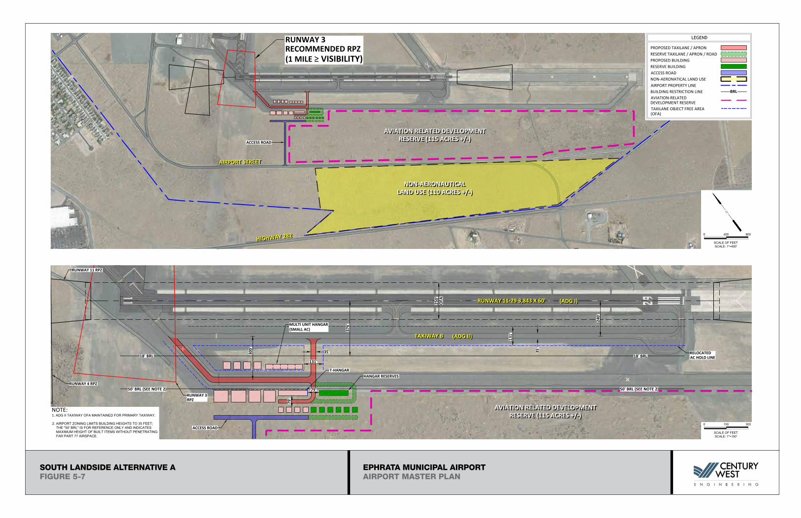
SOUTH LANDSIDE ALTERNATIVE A (FIGURE 5-7)
The south landside area provides development space capable of accommodating a variety of aviation uses,
with ample development reserves to accommodate demand well beyond the twenty year planning period.
The aviation use development area and reserve (100+ acres) are north of Airport Street, which is a surface
roadway connection to State Highway 282. A proposed land adjustment south of Airport Street has been
identified for future non-aeronautical use an airport-compatible industrial park. As noted earlier, the
extension of the utilities (water, sewer, electric) required to serve the new industrial park area is
considered to be a critical element affecting the feasibility of developing aircraft hangars in the south
landside area.
The proposed new hangar development utilizes the former parallel taxiway (now closed) for Runway 11/29
to provide access to the hangar sites. The western section of the former taxiway would be rehabilitated to
connect to the west end of Taxiway B, the south parallel taxiway for Runway 11/29. The proposed hangar
development area includes a second taxiway connection to Taxiway B that can be constructed as activity
warrants.
As proposed, a single row of small/medium conventional box hangars are located north of the access
taxiway. The hangars located on the north side of the access taxiway are adjacent to an 18-foot building
restriction line (BRL), established for Runway 11/29 (FAR Part 77 non-precision instrument runway).
Larger conventional hangars are located on the south side of the access taxiway. The additional setback
distance from Runway 11/29 will allow built items up to 50 feet without adverse impacts on FAR Part 77
airspace, although current zoning limits airport buildings to 35 feet. The south hangar row is configured
to also accommodate a multi-unit small airplane T-hangar. Construction of an additional taxilane stub is
required to access the south facing T-hangar units. The development of the taxilane stub also provides
access to several additional hangar sites on the south side of taxilane (four small conventional hangars
depicted).
A hangar development reserve is depicted at the east end of the proposed hangar area. The reserve
continues the linear development of hangars along the south side of the access taxiway (a second T-hangar
and multiple conventional hangars are depicted). Several increments of hangar expansion beyond the
reserve can be accommodated immediately adjacent to the closed taxiway and in secondary tiers, which
suggests that this area (115+ acres) provides virtually unlimited landside capacity for the foreseeable future.
The access taxiways for the south landside area use ADG II design standards, based on the potential for
accommodating ADG II aircraft in the new hangar area. The majority of these aircraft will operate on
Runway 3/21. An extension of Taxiway A to connect to Taxiway B1 is included among the proposed airside
improvements described earlier. It is noted that Taxiway B is designed to accommodate ADG II aircraft,
primarily to provide access to future south landside development.
EPHRATA AIRPORT
RUNWAY 4-22 3,467 X 150'RUNWAY 4-22 3,467 X 150'
LEGEND
TAXILANE OBJECT FREE AREA(OFA)
PROPOSED TAXILANE / APRON
FBO
65.5
'
131'
PAVEMENT MARKING
(ADG
II)
35' PARALLEL TAXILANE
79'
79'
PROPOSED BUILDING
MULTI UNITHANGAR
OVERHEAD ELECTRIC
OVERHEAD ELECTRIC
50'
240'
115' 115'
79'
79'
50'
TENANT PARKING / ROAD
300'
120'
TRANSIENT PARKING / LARGEAIRCRAFT AND HELICOPTER
FUEL E/F
FUELING APRON
AC LOADING / UNLOADINGTRANSIENT LARGE AC &HELICOPTER PARKING
AC LOADING / UNLOADINGTRANSIENT LARGE AC &HELICOPTER PARKING
VEHICLE PARKING
TERMINAL LANDSIDE ALTERNATIVE A FIGURE 5-4
50' 100'0'
Scale: 1"=50'
N
TRUEMAG.
50'
MULTI-ENGINEAC PARKING
MULTI-ENGINEAC PARKING
SMALL ACTIEDOWNSSMALL ACTIEDOWNS
FUELINGAPRON
BURY ABOVE GROUND POWERIN AREA OF NEW APRON
TO BE REMOVED
GLIDER PARKING OVERFLOWGLIDER STAGING AREA
131'
48'
79'
79'
AIRPORT RELATEDDEVELOPMENT
AIRPORT RELATEDDEVELOPMENT
VEHICLE GATE (F)
XX
XX
XX
X
RUNWAY OBJECT FREE AREA(OFA)
OFA
RUNWAY OFA RUNWAY OFA
TOFA
TOFA
TOFA
TOFA
EPHRATA MUNICIPAL AIRPORTAIRPORT MASTER PLAN
TERMINAL LANDSIDE ALTERNATIVE AFIGURE 5-4
EPHRATA AIRPORT
RUNWAY 4-22 3,467 X 150'RUNWAY 4-22 3,467 X 150'
FBO
65.5
'
131'
(ADG
II)
35' PARALLEL TAXILANE
79'
79'
MULTI UNITHANGAR
OVERHEAD ELECTRIC
50'
240'
115' 115'
79'
79'
50'
300'
120'
FUEL E/F
AC LOADING / UNLOADINGTRANSIENT LARGE AC &HELICOPTER PARKING
AC LOADING / UNLOADINGTRANSIENT LARGE AC &HELICOPTER PARKING
VEHICLE PARKING
TERMINAL LANDSIDE ALTERNATIVE B FIGURE (5-5)
50' 100'0'
Scale: 1"=50'
N
TRUEMAG.
50'
MULTI-ENGINEAC PARKING
MULTI-ENGINEAC PARKING
SMALL ACTIEDOWNSSMALL ACTIEDOWNS
FUELINGAPRON
BURY ABOVE GROUND POWERIN AREA OF NEW APRON
115'
48'
79'
LEGEND
TAXILANE OBJECT FREE AREA(OFA)
PROPOSED TAXILANE / APRON PAVEMENT MARKING
PROPOSED BUILDING OVERHEAD ELECTRIC
TENANT PARKING / ROAD
TRANSIENT PARKING / LARGEAIRCRAFT AND HELICOPTER
FUELING APRONTO BE REMOVED
GLIDER PARKING OVERFLOWGLIDER STAGING AREA
RUNWAY OBJECT FREE AREA(OFA)
OFA
OFA OFARUNWAY OFA RUNWAY OFA
TOFA
TOFA
TOFA
TOFA
EPHRATA MUNICIPAL AIRPORTAIRPORT MASTER PLAN
TERMINAL LANDSIDE ALTERNATIVE BFIGURE 5-5
XX
XX
XX
XX
XXXX
EPHRATA AIRPORT
RUNWAY 4-22 3,467 X 150'RUNWAY 4-22 3,467 X 150'
LEGEND
TAXILANE OBJECT FREE AREA(OFA)
PROPOSED TAXILANE / APRON
FBO
65.5
'
131'
PAVEMENT MARKING
(ADG
II)
35' PARALLEL TAXILANE
79'
79'
PROPOSED BUILDING
MULTI UNITHANGAR
OVERHEAD ELECTRIC
OVERHEAD ELECTRIC
50'
240'
115' 115'
79'
79'
50'
TENANT PARKING / ROAD
300'
120'
TRANSIENT PARKING / LARGEAIRCRAFT AND HELICOPTER
FUEL E/F
FUELING APRON
AC LOADING / UNLOADINGTRANSIENT LARGE AC &HELICOPTER PARKING
AC LOADING / UNLOADINGTRANSIENT LARGE AC &HELICOPTER PARKING
VEHICLE PARKING
TERMINAL LANDSIDE ALTERNATIVE C FIGURE (5-6)
50' 100'0'
Scale: 1"=50'
N
TRUEMAG.
50'
MULTI-ENGINEAC PARKING
MULTI-ENGINEAC PARKING
SMALL ACTIEDOWNSSMALL ACTIEDOWNS
FUELINGAPRON
TO BE REMOVED
GLIDER PARKING OVERFLOWGLIDER STAGING AREA
131'48'
79'79'
XX XX
PROPOSED/RELOCATED FENCE
BURY ABOVE GROUND POWERIN AREA OF NEW APRON
6 U
NIT
T-H
ANG
AR
RELOCATE FENCEOUTSIDE OF TOFA
RUNWAY OBJECT FREEAREA (OFA)
OFA
RUNWAY OFA RUNWAY OFA
TOFA
TOFA
TOFA
TOFA
EPHRATA MUNICIPAL AIRPORTAIRPORT MASTER PLAN
TERMINAL LANDSIDE ALTERNATIVE CFIGURE 5-6
EPHRATA AIRPORT
0 400 800
SCALE OF FEETSCALE: 1"=400'
N
18' BRL
376'
0 150 300
SCALE OF FEETSCALE: 1"=150'
18' BRL
250'
NON-AERONAUTICALLAND USE (110 ACRES +/-)
NON-AERONAUTICALLAND USE (110 ACRES +/-)
131'
131'
RUNWAY 11-29 3,843 X 60'RUNWAY 11-29 3,843 X 60'
TAXIWAY BTAXIWAY B
AIRPORT STREETAIRPORT STREET
HIGHWAY 282HIGHWAY 282
OFA
35'300'
RUNWAY 3RPZ
RUNWAY 4 RPZ
RUNWAY 11 RPZ
HANGAR RESERVES
MULTI UNIT HANGAR(SMALL AC)
(ADG I)(ADG I)
(ADG II)(ADG II)
35'
240'
RELOCATEDAC HOLD LINE
NOTE:1. ADG II TAXIWAY OFA MAINTAINED FOR PRIMARY TAXIWAY.
2. AIRPORT ZONING LIMITS BUILDING HEIGHTS TO 35 FEET; THE "50' BRL" IS FOR REFERENCE ONLY AND INDICATES MAXIMUM HEIGHT OF BUILT ITEMS WITHOUT PENETRATING FAR PART 77 AIRSPACE.
ACCESS ROAD
ACCESS ROAD
LEGEND
TAXILANE OBJECT FREE AREA(OFA)
PROPOSED TAXILANE / APRON
PROPOSED BUILDING
ACCESS ROAD
AVIATION RELATED DEVELOPMENTRESERVE (115 ACRES +/-)
AVIATION RELATED DEVELOPMENTRESERVE (115 ACRES +/-)
NON-AERONATICAL LAND USE
AVIATION-RELATEDDEVELOPMENT RESERVE
RESERVE TAXILANE / APRON / ROAD
RESERVE BUILDING
AIRPORT PROPERTY LINE
50' BRL (SEE NOTE 2) 50' BRL (SEE NOTE 2)79'
79'
BUILDING RESTRICTION LINE BRL
AVIATION RELATED DEVELOPMENTRESERVE (115 ACRES +/-)
AVIATION RELATED DEVELOPMENTRESERVE (115 ACRES +/-)