Final Report 7-1 CHAPTER 7 EARLY W ARNING SYSTEM 7.1 General There are two measures to mitigate damages of natural disasters: structural and non-structural measures. For flood damage mitigation, regulating the flood discharges by constructing dams and preventing the overflowing of excess floods by constructing river banks are examples of structural measures while methods to minimize the damage by implementing advance evacuation, regulating land use in the flood prone area, etc are some examples of the non-structural measures. Structural measures which can mitigate damage at a certain level are usually cost-intensive and take a longer period to implement. Non-structural measures, on the other hand, are relatively less expensive and effects can be realized sooner, that is, in terms of the reduction of human casualties. However, significant activities such as development of laws, enhancement of the people’s awareness and the eventual conversion of awareness into practice in people’s daily lives are required so that the effects of these non-structural measures will be sustainable. Since it will take time to implement structural measures, the earliest implementation of early warning and evacuation (EWE) System is desirable as one of the most effective non-structural measures. 7.2 Existing Conditions of Early Warning System in Indonesia 7.2.1 Concept of Meteorological Early Warning System in Indonesia by BMG BMG is currently developing the meteorological early warning system at the national level. Figure 7.2.1 shows the concept of meteorological early warning system. The whole Indonesian country is divided into 29 areas as shown in Figure 7.2.2, and regional centers are set for each area to gather and transmit information among the data observation equipment/stations and central BMG as well as central/regional organizations and people.
Transcript
Final Report
7-1
CHAPTER 7 EARLY WARNING SYSTEM
7.1 General There are two measures to mitigate damages of natural disasters: structural and non-structural measures. For flood damage mitigation, regulating the flood discharges by constructing dams and preventing the overflowing of excess floods by constructing river banks are examples of structural measures while methods to minimize the damage by implementing advance evacuation, regulating land use in the flood prone area, etc are some examples of the non-structural measures. Structural measures which can mitigate damage at a certain level are usually cost-intensive and take a longer period to implement. Non-structural measures, on the other hand, are relatively less expensive and effects can be realized sooner, that is, in terms of the reduction of human casualties. However, significant activities such as development of laws, enhancement of the people’s awareness and the eventual conversion of awareness into practice in people’s daily lives are required so that the effects of these non-structural measures will be sustainable.
Since it will take time to implement structural measures, the earliest implementation of early warning and evacuation (EWE) System is desirable as one of the most effective non-structural measures.
7.2 Existing Conditions of Early Warning System in Indonesia
7.2.1 Concept of Meteorological Early Warning System in Indonesia by BMG BMG is currently developing the meteorological early warning system at the national level. Figure 7.2.1 shows the concept of meteorological early warning system. The whole Indonesian country is divided into 29 areas as shown in Figure 7.2.2, and regional centers are set for each area to gather and transmit information among the data observation equipment/stations and central BMG as well as central/regional organizations and people.
The Study on Natural Disaster Management in Indonesia
7-2
row data
Inte
grat
or /
Sof
twar
e
row data
REGIONAL CENTER
(29)
1.Regional Disaster Reduction Center
2.Local Government3.Local Mass Media
(Electronic/ Printing)
4.Local Society
BMG JAKARTA
INTERNATIONAL METEOROLOGICAL
AGENCY
NATIONAL DISASTER PROCESSING CENTER
1.PRESIDENT/ VICE PRESIDENT
2.NATURAL DISASTER REDUCTION CENTER
3.MINISTER
4.NATIONAL MASS MEDIA
5.SOCIETY
1
MONITORING EQUIPMENT
Info (image)
3b Data & info
2 3a
REGIONAL PROCESSING
SYSTEMS
4
Weather Radar
Satellite Ground Station
row data
Data & Info
5
Automatic Weather
Sta.
NATIONAL DISSEMINATION SYSTEM
•Channels
•Type of Information
•etc
Info (local scale image)
1 Minute
LOCAL DISSEMINATION
SYSTEM
3 Minutes2 Minutes
Source: BMG
Figure 7.2.1 General Concept of Meteorological Early Warning System (MEWS)
MRC 1
MRC 5
MRC 4MRC 3
MRC 2
MRC 9MRC 22
RMC 21
MRC 23
MRC 19
MRC 17
MRC 16
MRC 18MRC 20
MRC 28
MRC 29
MRC 11
MRC 12MRC 10
MRC 7
MRC 6
MRC 15
MRC 14
MRC13
MRC 8
MRC 27
MRC 26MRC 25
MRC 24
METEOROLOGICAL REGIONAL CENTER BMGBMG
Source: BMG
Figure 7.2.2 Regional Division for Meteorological Early Warning System by BMG
Final Report
7-3
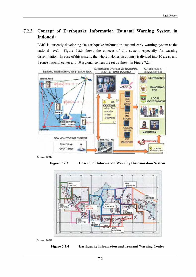
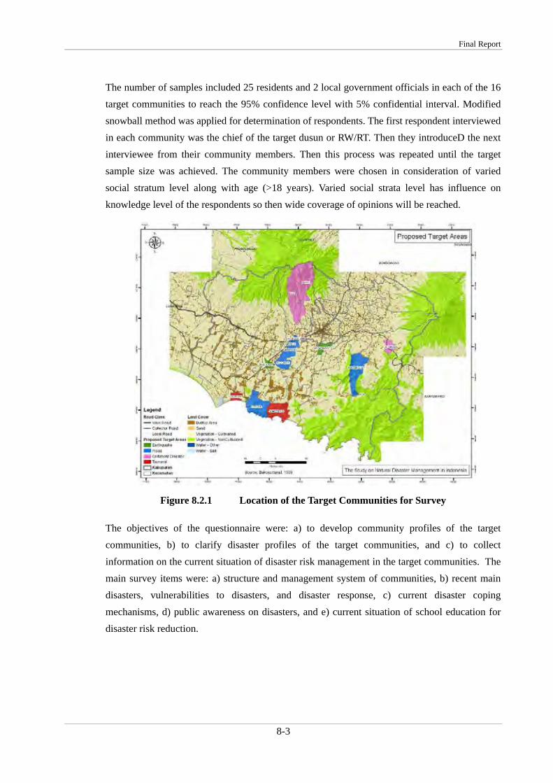
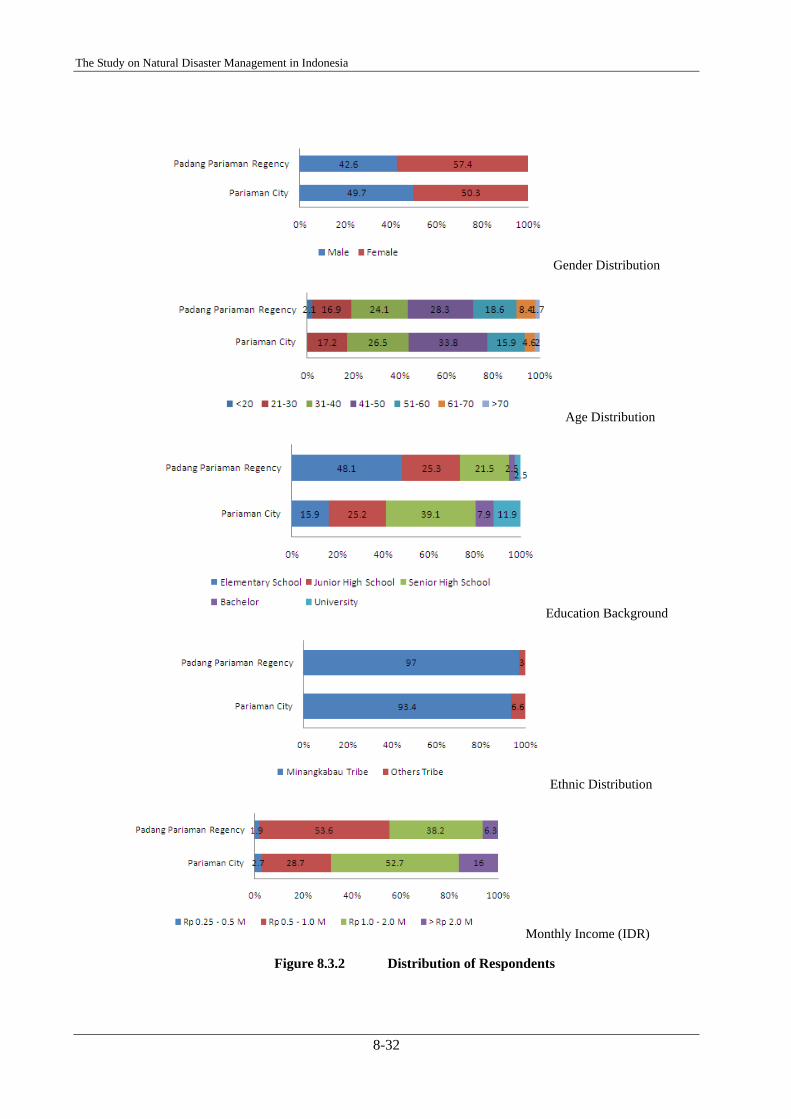
7.2.2 Concept of Earthquake Information Tsunami Warning System in Indonesia BMG is currently developing the earthquake information tsunami early warning system at the national level. Figure 7.2.3 shows the concept of this system, especially for warning dissemination. In case of this system, the whole Indonesian country is divided into 10 areas, and 1 (one) national center and 10 regional centers are set as shown in Figure 7.2.4.
Source: BMG
Figure 7.2.3 Concept of Information/Warning Dissemination System
Source: BMG
Figure 7.2.4 Earthquake Information and Tsunami Warning Center
The Study on Natural Disaster Management in Indonesia
7-4
7.3 Existing Conditions of Early Warning in East Java Province and Kabupaten Jember
7.3.1 Meteorological Observation and Early Warning System in East Java Province by BMG
1) Automatic Weather Stations
According to the information from official of BMG Malang, five automatic weather stations (AWSs) were installed by BMG in East Java province before 2007: namely, - Karangkates (in Kabupaten Malang) - Karangploso (in Kabupaten Malang) - Juanda (in airport in Surabaya) - Banyuwangi (in Kabupaten Banyuwangi) - Perak (in harbor)
In January 2007, four new AWSs with telemeter system in GSM were installed to the following Kabupatens: - Jember (observation started on January 18, 2007) - Lamongan - Malang - Trenggalek
These telemetering AWSs have the function of warning dissemination by SMS (short messaging service). In case observation values exceed the threshold set by BMG, a warning message will be sent to representatives of regional disaster management and BMG offices by SMS.
2) Observation Items
Observation items of each AWS are basically rainfall, temperature, humidity, pressure, sun radiation, wind speed and direction. Each item is recorded every one hour.
3) Present Condition of AWSs
Although the above AWSs have been installed in a number of Kabupaten, many AWSs have various problems. Some of them stem from the sensors and others from the communication system. For example, in case of AWS in kecamatan Mayang in Kabupaten Jember, the sensors of pressure and wind speed and direction as well as the communication system (data transmission system) are malfunction condition at present. The communication system functioned only two months after its installation in January 2007.
Several AWSs have a trouble especially in their communication system; therefore, BMG has been proceeding with the exchange of equipment for communication.
Final Report
7-5
4) Future Plan by BMG Malang
BMG plans to construct meteorological climatology early warning System (MCEWS), which will compile all the meteorological and climatological information from the manual, automatic weather and radar stations in East Java province. The center will be build at Juanda airport in Surabaya.
7.3.2 Meteorological Observation System and Early Warning System in Kabupaten Jember
1) Meteorological Stations and Early Warning by BMG
Cooperation between Kabupaten Jember and BMG for meteorological observation, and meteorological observation activity in Kabupaten Jember by BMG itself have started in 2005 in the wake of the Notohadinegoro airport construction plan in Wirowongso in Kabupaten Jember. Then Kabupaten Jember needed various meteorological information for construction and future operation of the airport and technical support from BMG. The transportation agency was assigned as the representative organization of Kabupaten Jember side for coordination with BMG, and this cooperative system still continues although the airport construction is suspended at present.
At present, there are two meteorological stations managed by BMG in Kabupaten Jember. One is a manual observation station on the premises of the office of Irrigation agency in Jubung, where observation started from January 2006. Observation equipments of Jubung station are assets of Kabupaten Jember, and BMG is responsible only for operation and maintenance. The other is a telemetering automatic weather station installed in January 2007 on the premises of the Kecamatan office of Mayang. Observation equipments of Mayang station belong to BMG itself and operation and maintenance is also conducted by BMG although the land for installing equipments is provided by Kabupaten Jember.
In the Jubung station, temperature, humidity, pressure and wind speed and direction is measured every hour and rainfall is measured every three hours from 7 AM to 7 PM by staff of BMG Malang. The observation data is brought back to BMG Malang once a week and arranged and compiled in BMG Malang. Photo 7.3.1 show the conditions in Jubung station.
The Study on Natural Disaster Management in Indonesia
7-6
Photo 7.3.1 Observation Equipment in Jubung Station
In the Mayang station, temperature, humidity, rainfall, pressure, sun radiation and wind speed and direction are automatically measured and recorded every hour. This station has telemetering communication system although the system is malfuncting at present. When the system works properly, the observation data is sent to BMG central and BMG Malang regularly by GSM. This station can automatically send warning message by using SMS. In case observation data reaches the thresholds, a warning message is sent to Vice Bupati of Kabupaten Jember, camat (kecamatan leader) in Mayang, a military commander at kecamatan level, a head of police at kecamatan level, transportation agency and BMG offices such as in central and Malang.
The following are the thresholds for warning, which are set for Mayang station: - Rainfall: 30 mm/hour - Temperature: 36 degree centigrade (more than 36 degree centigrade) - Humidity: 50% (less than 50%)
The rainfall threshold was set by average value of Indonesian country, which is defined as an Indonesian general standard value by BMG. The threshold of temperature and humidity was set by observation data from 1999 to 2006 of Kabupaten Jember.
2) Response to Early Warning
As mentioned above, a warning message is sent to Vice Bupati of Kabupaten Jember, camat in Mayang, a military commander at kecamatan level, a head of police at kecamatan level, transportation agency and BMG offices.
According to the interview at the related agency, the following is confirmed as response to receiving a warning message:
Photo 7.3.2 AWS in Mayang
Final Report
7-7
- After Vice Bupati receives the message, he will order the military commander to do next actions.
- The warning information will be delivered along the rules for information flow of disaster management SATLAK -> sub-district (kecamatan) -> village (kelulahan/desa) -> sub-village (Linkungan/Kampung/Dusun) -> RW -> RT
Other concrete action plan or standard operation procedure for emergency response after warning is not decided yet because there haven’t been any meetings among relevant agencies to discuss about the fixed procedures so far.
7.3.3 Rainfall Observation by Irrigation Agency There are 74 rainfall observation stations operated by Irrigation agency. According to the official of Irrigation agency, when more than 100 mm daily rainfall is observed in the station, this information shall be informed to the representative observer from the local observer of each station. However, it is not sure whether this information is transmitted to the community leaders or people from the irrigation agency, and how to utilize the information for warning at present.
7.3.4 Hydrological Observation by Irrigation Agency and Other Agencies Irrigation agency sets up the monitoring post of “Pos Pantau” in and around the intake facilities with high disaster potential of flood and sediment disasters. Officer of Irrigation agency are assigned to monitor the discharge and water level and they reports to regional office of Irrigation agency regularly (basically once a day). In case of heavy rainfall and increased river flow, the warning will be informed to their superior by mobile phone, then the superior is supposed to inform to his superior (representative observer) and leader of village/sub-village by mobile phone.
The other agencies such as forestry and plantation agency, forestry companies and local communities have and are operating the similar monitoring posts system.
7.3.5 Information Dissemination at Community Level In Java area including Kabupaten Jember, there is a traditional information dissemination system using drum of “Kenthongan” in community. Various information is passed on by rhythmically beating the drum. This system has been using not only in emergency situation like in disaster but also for routinely informing of ceremonial events to the people. It had gone out of use due to the modernization in some areas, but its effectiveness was reevaluated after the sediment disaster in recent years.
The Study on Natural Disaster Management in Indonesia
7-8
Photo 7.3.3 Drum put in Houses and the Rhythmic Pattern by Type of Information
7.3.6 Tsunami Early Warning System in East Java Province and Kabupaten Jember According to the information from an official of BMG, BMG has built the AWSs including geophysical stations for tsunami and earthquake in Kabupaten Banyuwangi and in Tretes of Kabupaten Pasuruan, whereas early warning system for tsunami has not been fixed yet. As for Kabupaten Jember, AWS for tsunami is now under planning in Kecamatan Ambuly in south part of Jember.
7.4 Plan for Early Warning and Evacuation in Kabupaten Jember
7.4.1 Basic Understanding for Making Plan In order to prepare the plan of early warning and evacuation in Kabupaten Jember, its basic understanding is summarized below.
1) Existing Condition of Early Warning and Evacuation in Kabupaten Jember - Although BMG has been developing the telemetering monitoring and early warning
system, it is not sufficient to cover all the Kabupaten Jember and will take time due to some problems such as the deficit of budget.
- Early warning criteria is indefinite. - Data for setting up the criteria is insufficient. - Actual and local observation and warning activities are carried out by several agencies;
however, it has not been conducted systematically. - Although basic flow of information transmission has been fixed, standard for warning
issuance and concrete procedure for warning dissemination are unclear. - Evacuation plan including such as evacuation place and evacuation route, is not prepared.
2) General Limitation of Early Warning - Disasters originating by rainfall are able to issue the early warning in regional level;
however, early warning for tsunami needs an observation system at the national level.
Final Report
7-9
- In order to set the warning criteria, long-term accumulation of accurate data is crucial. - Although accuracy of warning criteria will be improved by statistical analysis or simulation
analysis, it is still difficult to predict the occurrence of disaster with high probability.
3) General Requirement for Early Warning - For secure warning transmission and dissemination, multiple methods shall be prepared. - Data transmission methods are desirable to be stable and reliable even in disaster. - In order to lead warning or evacuation orders to actual and secure evacuation activities,
information shall be disseminated by the organization and/or individual who is trusted from the people.
- Evacuation place and evacuation route shall be settled in advance and announced to the people.
- People shall fully understand the relationship between natural phenomena and disasters, and mechanism of disasters.
7.4.2 Plan Based on the above basic understanding, the plan for early warning and evacuation in Kabupaten Jember is prepared as follows.
1) Objective
The objectives of the plan are; - Saving of people’s lives - Reduction of property damage
2) Actions/Items to be Conducted
The actions and items to be conducted for effective early warning system are described below.
(Common) - Establishment of information transmission route, and determination of transmission
methods As for the transmission methods, stable and reliable methods such as utilization of traditional and indigenous method of Durum, siren, mobile phone, loudspeaker car, etc. will be considered
- Concretization, documentation and popularization of role allocated to each organization/agency and leader/individual related to information transmission and evacuation
- Capacity enhancement to organizations concerned - Development of leaders and training of leader
The Study on Natural Disaster Management in Indonesia
7-10
- Education, public awareness and drill to the people through the community based disaster management activities, such as education about disaster mechanism, drill for secure evacuation and concrete and continuous activities of rainfall measurement by people temselves with the aim of understanding relationship between disaster and rainfall
- Setting/selection of evacuation place and evacuation route and their popularization - Accumulation and analysis of disaster data and natural condition data like rainfall data
In cooperation with organizations concerned such as BMG, data about relationship between disaster and natural phenomena shall be accumulated in order to set the accurate warning criteria
(Flood) - Establishment of systematic and integrated hydrological observation system of rainfall and
water level and its data transmission system by utilizing existing activities of organizations concerned, in order to develop early warning system
- Accumulation of basic meteorological and hydrological data in order to set the warning criteria
- Determination of measuring point of water level and accumulation of data, for setting of warning criteria in high-frequency inundation areas
- Recommendation of location of hydrological stations to be newly installed, and selection of hydrological stations to upgrade observation equipment to a self-recording type or with telemetering function
- Education and public awareness to the people living in high-frequency flood area and flood potential area by using hazard and risk maps
(Sediment Disasters) - Accumulation of basic meteorological and hydrological data in order to set the warning
criteria (same as flood) - Education and public awareness to the people living in high-frequency hazard area and
hazard potential area by using hazard and risk maps - Education to the people about relationship between rainfall and sediment disasters - Simple measurement by people and/or official in
the locations where the predictive phenomena is observed, and education to them about the mechanism of landslide
Final Report
7-11
(Earthquake)
Early warning is extremely difficult.
(Tsunami) - Establishment of early warning system by BMG - Development of transmission and dissemination system of BMG’s warning to the people - Education about mechanism and risk of tsunami to the people living in coastal areas
7.5 Existing Conditions of Early Warning in West Sumatra Province, Kabupaten Padang Pariaman and Kota Pariaman
7.5.1 Existing Conditions of Early Warning in West Sumatra Province 1) Observation Stations in West Sumatra Province
There are five types of observation stations managed by BMG in West Sumatra Province. 1) Climate observation station in Sicincin of Kabupaten Padang Pariaman 2) Earthquake observation station in Kota Padang Panjang 3) Marine observation station in Teluk Bayur port of Kota Padang 4) Meteorological observation station in Bandara Tabing airport in Kota Padang 5) Global atmosphere observation station in Koto Tabang of Kabupaten Bukittinggi
In addition, three Kabupatens of West Sumatra Province have AWSs prepared and managed by their own budget of each Kabupaten itself. There is no AWS in Kabupaten Padang Pariaman and Kota Pariaman.
2) Tsunami Early Warning System in West Sumatra Province
As of September 2008, six siren towers for tsunami warning have been installed by BMG in six Kabupaten/Kotas of Pasaman Barat, Padang Pariaman, Kota Pariaman, Padang, Pesisir Selatan and Mentawai, and utilized for dissemination of tsunami warning. They are managed by the Province.
7.5.2 Existing Conditions of Early Warning in Kabupaten Padang Pariaman 1) Meteorological Observation System and Early Warning System in Kabupaten Padang
Pariaman
(1) Meteorological Stations and Early Warning by BMG
Sicincin observation station is a main observation station of BMG in Kabupaten Padang Pariaman. Temperature, humidity, rainfall, sun radiation, evaporation, and wind speed and direction are
The Study on Natural Disaster Management in Indonesia
7-12
measured and recorded every one hour in this station. Rainfall data has been recorded at least since 1961, and it has been arranged as a digital data since 1985 although data until 1990 includes many missing items. An automatic digital rainfall gauge has been installed since 2005, and hourly rainfall data was recorded and organized from January to June in 2005 and during all the year in 2006 and 2007.
Limau Purut observation station is a secondary rainfall observation station of BMG in Kabupaten Padang Pariaman. It is managed by Farming & Plantation Agency and observation data is delivered to BMG Sicincin once a month or once a week as requested. Daily rainfall data during 50 years is stored in this station.
(2) Utilization for Early Warning
BMG Sicincin and Kabupaten Padang Pariaman have not entered into any agreement for providing rainfall or flood information aiming at early warning. Therefore, urgent information is not transmitted to Kabupaten even when very heavy rainfall is observed. In this regard, however, Kabupatan receives data of tidal level, wind and rainfall from BMG once a month or once a week where necessary.
2) Hydrological Observation and Early Warning supported by Irrigation Agency in Kabupaten Padang Pariaman
There are 11 major rivers in Kabupaten. Each river has about three or four water gates for irrigation, which are managed by exclusive officers of Irrigation Agency. The officer is in continuous presence of each water gate and manages water gate around the clock, especially in the rainy season. Their main work is adjustment of irrigation water.
Even though it is not their obligation, when the officers notice or observe predictive phenomena of flood, such as rising water level and turbidity of river water, they will vocally inform neighboring residents of this information. When this information is transmitted to camat (leader of kecamatan) through people, then the camat transmits it to SATLAK by radio transmission and others, and subsequently SATLAK transmits a flood warning to relevant camats in the downstream area.
Kapupaten has a future plan to provide information transmission tools such as radio transmission to officers of water gates and to conduct systematic information/warning transmission. However, the above uncertain information transmission by grapevine and partial use of radio transmission is only carried out at present.
Community Residents
Irrigation officer Camat SATLAK Camat
Radio transmission Voice, Kenthongan, etc.
People
Final Report
7-13
3) Hydrological Observation and Early Warning by Community
In the communities of flood prone area, residents observe water level of rivers by themselves, and if they notice dangerousness of flood, they inform of it to other residents and community leader of Nagari (village) or Korong (sub village) vocally or by Kenthongan and others. Evacuation is conducted by decision of residents themselves. Current activities of SATLAK against floods focus on response after disaster occurrence. In addition, training for community has been carried out by Kabupaten.
4) Tsunami Early Warning System in Kabupaten Padang Pariaman
(1) Information Transmission Equipments
A siren tower for tsunami warning is installed at fishing training school in coastal area of Nagari Campago in kecamatan V Koto Kp. Dalam.
Radio transmission tools of Kabupaten are as follows:
A fixed main radio transmission station is put in BAKESBANG office. Mobile radio transmissions are provided to all of camat (total 17 persons). Due to a capacity of the main station, radio waves can directly reach only nine camats (kecamatans) from the main station. In addition to them, fire fighting agency has fixed radio transmission equipment, but it is used only for fire.
Kabupaten plans to purchase five satellite telephones for emergency in 2008, which will be utilized by Bupati (governor of Kabupaten), Wakil Bupati (vice governor of Kabupaten), Kapoles (head of police), SEKDA (secretary of governor), head of BAKESBANG.
(2) System for Disaster Information Transmission, Early Warning and Evacuation
(i) As of 2008
SATLAK receives information from BMG through the Internet as well as indirectly through a siren. The siren tower is operated by SATKORLAK.
After information/warning is issued or received as described in the above, the information will be transmitted by the following routes: 1) Using a computer of POSKO in BAKESBANG office, SMS (short message service by
mobile phone) is automatically sent to members of SATLAK and camats. They will transmit information to communities by various means.
2) The warning/information disseminated to community by the siren is transmitted to SATLAK through an operator, and subsequently SATLAK transmits it to camats and
Wakil Nagari/Korong Community Residents SATLAK
The Study on Natural Disaster Management in Indonesia
7-14
communities, which are far from the siren. Audible distance of the siren is about 2.5 km in radius.
Details of information transmission such as contents of announcement for warning/information transmission and how to beat a Kenthongan (drum) are described in PROTAP.
(ii) 2009 or later
SATLAK will receive information from BMG through the Internet as well as directly from an observation buoy. Then, information/warning will be transmitted to members of SATLAK and camats through automatic an SMS sending system in SATLAK, as well as will be disseminated to communities by the siren operated directly by SATLAK.
As of 2008 the siren tower is the only one in Kabupaten. Kabupaten has a future plan to install the siren towers to all the coastal villages (nine villages (Nagari)). Approximate cost for a system for direct receipt of information from the buoy, and installation of two sirens are 1.5 billion Indonesian Rupees. Priority of installation of the sirens in the plan of Kabupaten is as follows:
First priority: - Northern Nagari in kecamatan Ulakan Tapaki - Nagari Kataping in kecamatan Batang Anai Second priority: One each of all the kecamatans except kecamatans in which a siren
tower is already installed Third priority: All the remaining coastal Nagari
High-priority kecamatans are located in southern part of Kabupaten.
Buoy
Satellite
BMG
POSKO in SATLAK
Member of SATLAK (23 per.)
Computer Camat (17 per.)
Operator
Siren SATKORLAK
Satellite
Internet Radio
SMS
SMS
Community
Community
・・・・・
SATLAK Community
Camat
Tel,Loudspeaker, Kenthongan, etc.
Tel,Loudspeaker, Kenthongan,Radio, etc.
Final Report
7-15
7.5.3 Existing Conditions of Early Warning in Kota Pariaman 1) Meteorological Observation System and Early Warning System in Kota Pariaman
(1) Meteorological Station
Daily rainfall is observed in Santok station in Kota Pariaman. This station is managed by irrigation agency of Kabupaten.
(2) Utilization for Early Warning
Observation result in Santok station is not utilized for early warning.
In addition, BMG Sicincin and Kota Pariaman have not entered into any agreement for providing rainfall or flood information aimed at early warning. Therefore, any urgent information is not transmitted to Kota even when very heavy rainfall is observed.
2) Hydrological Observation and Early Warning by Community
(1) Community in Flood-Prone Area (Downstream of Mangau River)
Residents in downstream area of the Mangau river where is a flood prone area, organize disaster management community, namely KPBADM (Komite Peduli Bancana Alam Desa Marunggi). KPBADM has not conducted regular hydrological observation activities such as water level observation. However, they can evaluate a possibility of flood occurrence by themselves from the conditions of wind direction, tidal level, rainfall amount and others, using their experimental
Buoy
Satellite
BMG
POSKO in SATLAK
Member of SATLAK
(23 per.)
Computer Camat (17 per.)
Siren SATLAK
Satellite
Internet Radio
SMS
SMS
Community
Community SATLINMAS
Tel,Loudspeaker, Kenthongan, etc.
Siren
Siren
・ ・ ・
The Study on Natural Disaster Management in Indonesia
7-16
knowledge. Then, if the flood possibility is considered as high, they inform it to other residents vocally or by durum and others. Evacuation is conducted by decision of residents themselves.
Kota governmental agencies including Public Works Agency have not conducted regular observation of water level in the river. Current activities of SATLAK against flood focus on training to community, by which community can perform proper actions in an emergency. In addition, SATLAK carries out provision of commodities upon request of community as a response after disaster occurrence.
NGO and ITB (Institut Teknologi Bandung) as well as Kota government have conducted education and training of disaster management to this community.
(2) Other Communities in Flood Risk Area
Evacuation is conducted according to decision of camat or head of Nagari.
3) Tsunami Early Warning System and Kota Pariaman
(1) Information Transmission Equipments
A siren tower for tsunami warning has been installed behind Kota government office; however, it is malfunctioning due to lightning damage as of September 2008.
Radio transmission tools of Kabupaten are as follows:
Three fixed main radio transmission stations are put in mayor’s house, Kota government office and former Kota government office. Ten (10) mobile radio transmissions are managed by BAKESBANG office.
BAKESBANG plans to provide mobile radio transmissions to all the coastal villages (14 Desa) from BAKESBANG around next year.
(2) System for Disaster Information Transmission, Early Warning and Evacuation
Kota has not developed an information receipt system from BMG through the Internet like Kabupaten; therefore, five representatives of Kota (mayor, head of BAKESBANG, a staff of BAKESBANG, head of PU, and a staff of BAPPEDA) receive information directly from SATKORLAK by SMS or telephone. SATKORLAK transmits the information on earthquake and tsunami as well as meteorological information from BMG.
BAKESBANG KPBADM
Community ResidentsVoice, drum
Tel, Radio transmission
Final Report
7-17
7.6 Plan for Early Warning and Evacuation in Kabupaten Padang Pariaman and Kota Pariaman
7.6.1 Basic Understanding for Making Plan In order to prepare the plan of early warning and evacuation in Kabupaten Padang Pariaman and Kota Pariaman, basic understanding is summarized below.
1) Existing Condition of Early Warning and Evacuation in Kabupaten Padang Pariaman and Kota Pariaman
(Flood and Sediment Disasters) - Actual and local observation and warning activities are carried out by irrigation agency and
communities; however, it has not been conducted systematically. - Early warning criteria is indefinite. - Data for setting up the criteria is insufficient. - Although basic flow of information transmission has been fixed, standard for warning
issuance and concrete procedure for warning dissemination are unclear. - Evacuation plan including such as evacuation place and evacuation route, is not prepared.
(Earthquake and Tsunami) - Although early warning system using sirens is developed and operated in collaboration
with BMG and Province, it is not sufficient to cover all the coastal area of Kabupaten and Kota. As for Kota, a system to receive information directly from BMG has not been developed.
Buoy
Satellite
BMG SATKORLAK Member of SATLAK (5 per.)
Siren SATKORLAK
Satellite
Internet Radio
SMS Community
SATLAK Community
Camat
Voice, Tel, Mosque Loudspeaker, Tabuah, Car, etc.
Tel, Mosgue Loudspeaker, Tabuah, Radio, etc.
Other Member of SATLAK
Related organs. (Gov. organs.
Public Organs. ORARI, etc.)
Tel, SMS, Radio transmission
The Study on Natural Disaster Management in Indonesia
7-18
2) General Limitation of Early Warning - Disasters originated from rainfall are able to issue the early warning in regional level;
however, early warning for tsunami needs an observation system at the national level. - In order to set the warning criteria, long-term accumulation of accurate data is crucial. - Although accuracy of warning criteria will be improved by statistical analysis or simulation
analysis, it is still difficult to predict the occurrence of disaster with high probability.
3) General Requirement for Early Warning - For the secure warning transmission and dissemination, multiple methods shall be
prepared. - Data transmission methods are desirable to be stable and reliable even in disaster. - In order to lead warning or evacuation orders to actual and secure evacuation activities,
information shall be disseminated by the organization and/or individual who is trusted from the people.
- Evacuation place and evacuation route shall be settled in advance and announced to the people.
- People shall fully understand the relationship between natural phenomena and disasters, and mechanism of disasters.
7.6.2 Plan Based on the above basic understanding, the plan for early warning and evacuation in Kabupaten Padang Pariaman and Kota Pariaman is prepared as follows.
1) Objective
The objectives of the plan are; - Saving of people’s lives - Reduction of property damage
2) Actions/Items to be Conducted
The actions and items to be conducted for effective early warning system are cited below.
(Common) - Establishment of information transmission route, and determination of transmission
methods As for the transmission methods, stable and reliable methods such as utilization of traditional and indigenous method of durum, siren, mobile phone, loudspeaker car, etc. will be considered
Final Report
7-19
- Concretization, documentation and popularization of role allocation of each organization/agency and leader/individual related to information transmission and evacuation
- Capacity enhancement to organizations concerned - Development of leaders and training for the leader - Education, public awareness and drills to the people through the community based disaster
management activities, such as education about disaster mechanism, drills for secure evacuation and concrete and continuous activities of rainfall measurement by people itself with the aim of understanding relationship between disaster and rainfall
- Setting/selection of evacuation place and evacuation route and their popularization - Accumulation and analysis of disaster data and natural condition data like rainfall data
In cooperation with organizations concerned such as BMG, data about relationship between disaster and natural phenomena shall be accumulated in order to set accurate warning criteria
(Flood) - Establishment of systematic and integrated hydrological observation system of rainfall and
water level and its data transmission system by utilizing existing activities of organizations concerned, in order to develop early warning system
- Accumulation of basic meteorological and hydrological data in order to set warning criteria - Determination of measuring point of water level and accumulation of data, for setting of
warning criteria in high-frequency inundation areas - Recommendation of location of hydrological stations to be newly installed, and selection
of hydrological stations to upgrade observation equipment to a self-recording type or with telemetering function
- Education and public awareness to the people living in high-frequency flood area and flood potential area by using hazard and risk maps
The Study on Natural Disaster Management in Indonesia
7-20
(Sediment Disasters) - Accumulation of basic meteorological and hydrological data in order to set the warning
criteria (same as flood) - Education and public awareness to the people living in high-frequency hazard area and
hazard potential area by using hazard and risk maps - Education to the people about relationship between
rainfall and sediment disasters - Simple measurement by people and/or officials in
the locations where the predictive phenomena is observed, and education to them about the mechanism of landslide
(Earthquake)
Early warning is extremely difficult.
(Tsunami) - Establishment of early warning system by BMG - Development of transmission and dissemination system of BMG’s warning to the people
(installing siren towers) - Education about mechanism and risk of tsunami to the people living in coastal areas
Final Report
8-1
CHAPTER 8 COMMUNITY BASED DISASTER RISK MANAGEMENT Disaster reduction measures are most successful when they involve direct and active participation of the people most likely to be exposed to hazards. Communities must be aware of the importance of disaster reduction for their own well-being. In addition, local leaders, including both men and women drawn from many political, social and economic sectors need to assume the primary responsibility for the protection of their own communities. Based on these basic policies, community based disaster risk management activities were conducted as one of the programs in the Study for enhancing regional disaster risk management capacities.
8.1 Community capacities to be strengthened for effective disaster risk management Capacities to be strengthened for effective disaster risk management are divided into the following three categories:
a) Comprehension of natural disasters and awareness of importance of disaster risk management
- Understanding of mechanism of hazards and risks, and impact of disasters in the context of one’s own and one’s own community situation
- Realizing the importance of disaster risk management and considering measures and actions to be taken for reducing damage caused by future disasters
b) Capacity to take necessary actions for disaster reduction in coordinated manner
- Taking measures for preparedness and mitigation of vulnerabilities during normal times, and proper and prompt action in case of emergency based on proper understanding
- Understanding of importance of collaboration of neighbors and communities as well as with related organizations for reducing disaster damages, and taking actions in a coordinated manner
- Making proposals to related organizations including local government for addressing the necessary measures and problems which are difficult to be handled by themselves and communities
c) System to support and improve community actions and awareness for disaster risk management
- Leaderships for realizing disaster resilient communities
- Establishing a proper system for sustainable actions in the communities
The Study on Natural Disaster Management in Indonesia
8-2
Community activities were conducted to enhance the above capacities in Kabupaten Jember, Kabupaten Pariaman, and Kota Pariaman.
8.2 Activities for Capacity Development of the Communities in Kabupaten Jember
8.2.1 Community Survey and Characteristics of Community-based Disaster Management in Kabupaten Jember Questionnaire and interview survey to individuals and local government officers was conducted in August 2007 in order to use the results for baseline data of the community activities in Kabupaten Jember, model area in East Java.
1) Target Communities and Survey Methodology
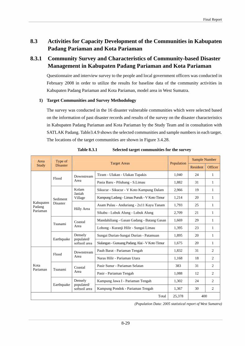
The survey was conducted in the 16 disaster vulnerable communities which were selected based on the information of past disaster records and result of the survey on the disaster characteristics in Kabupaten Jember by the Study Team and in consultation with SATLAK Jember. Table 8.2.1 shows the selected communities and sample numbers in each target. The location of the target communities are shown on Figure 8.2.1.
Table 8.2.1 Selected target communities for the survey
Sample NumberType of Disasters
Kecamatan Desa Population Dusun Residents Officials
e Ajung Wirowongso 7,413 Renes 25 2 Total 157,782 429
(Population Data: 2005 Statistics/ Average Number of Dusun in one Desa is 3.8 )
Final Report
8-3
The number of samples included 25 residents and 2 local government officials in each of the 16 target communities to reach the 95% confidence level with 5% confidential interval. Modified snowball method was applied for determination of respondents. The first respondent interviewed in each community was the chief of the target dusun or RW/RT. Then they introduceD the next interviewee from their community members. Then this process was repeated until the target sample size was achieved. The community members were chosen in consideration of varied social stratum level along with age (>18 years). Varied social strata level has influence on knowledge level of the respondents so then wide coverage of opinions will be reached.
Figure 8.2.1 Location of the Target Communities for Survey
The objectives of the questionnaire were: a) to develop community profiles of the target communities, b) to clarify disaster profiles of the target communities, and c) to collect information on the current situation of disaster risk management in the target communities. The main survey items were: a) structure and management system of communities, b) recent main disasters, vulnerabilities to disasters, and disaster response, c) current disaster coping mechanisms, d) public awareness on disasters, and e) current situation of school education for disaster risk reduction.
The Study on Natural Disaster Management in Indonesia
8-4
2) General characteristics of the target communities
In general, people in the targeted communities obtain livelihood mainly from agriculture as shown in Table 8.2.2. A few male respondents had their own business, i.e. trading; however, employees also were a large portion of them. Usually, they work at plantation companies around their living areas. The respondents from Kecamatan Panti owned a business mostly for household device production, such as wok, pan, and oven. Respondents from Kecamatan Rambipuji were mostly agricultural implement traders. 44% of female respondents worked in agricultural sector and 6% of them were housewives. This result shows that females play a significant role to increase family income to cover daily consumption.
Average monthly income of 42% of respondents is in the range of IDR 0.25 - 0.5 M as shown in Figure 8.2.2. Assuming each family has four members (father, mother, and two children), monthly income per capita is calculated in the range of IDR 62,500 - 125,000. According to the 2006 government poverty limits, the criterion of “poor” is monthly income IDR 131,256. Therefore it can be concluded that approximately half of residents are below the poverty line.
Table 8.2.2 Population density and main livelihood of the target communities
The income level of respondents of poverty is considered to correlate with educational background. As shown in Figure 8.2.2, 48% of respondents only have elementary school education. Total rate of the respondents who have at least secondary school level education is approximately 6.5% below the national level (32% in Kabupaten Jember, and 38.5% at national level).
Figure 8.2.3 Possession of Communication & Transportation Devices
As Figure 8.2.3 shows, nearly 70% of respondents have a radio at their home and 63% of them have a television. However, the persons who have mobile phones among the respondents totaled 22% and those who have fixed phone are only 13%. The reason for the low percentage of ownership of the fixed phone is due to the unavailability of fixed phone network in the high
Gender Distribution
67 33
0% 20% 40% 60% 80% 100%
Resp
onde
nts
Tota
l Male Female
Age Distribution
9 24 35 19 13
0% 20% 40% 60% 80% 100%
Respondents
Total
20-30 30-40 40-50 50-60 <60
Educational Background
48 14 17 1 20
0% 20% 40% 60% 80% 100%
Resp
on
dents
Tota
l
Elementary School Secondary School Senior School
University Others
Ethnic Distribution
54 43 3
0% 20% 40% 60% 80% 100%
RespondentsTotal
Java Madura Others
Monthly Income (IDR)
15 42 28 8
0% 20% 40% 60% 80% 100%
Resp
on
dents
Tota
l
<0.25M 0.25-0.5M 0.5-1.0M
1.0-2.0M <2.0M
Possesion of Communication Devices
67 63
1322
0
20
40
60
80
100
Radio TV FixedPhone
MobilePhone
%
Possesion of Transportation Devices
8 6
47 40
0
20
40
60
80
100
Car Van Motorbike Bicycle
%
The Study on Natural Disaster Management in Indonesia
8-6
terrain areas. Considering the above situation, radio can be considered as most useful device to deliver emergency information to many members of the community.
With regard to the ownership of transportation devices, very few numbers of the respondents had cars (8%) or vans (6%). However, 47% of the respondents owned motorbikes and 40% of them bicycles. Therefore, it is very important to identify the car or van owners in advance in order to get support for the evacuation of community members who have difficulty in quick escape.
3) Social characteristics of the target communities
Figure 8.2.4 Social Capital Condition
From the result of the survey, it is clear that a large part of respondents feel their communities are in good condition in terms of social capital. All three questions on social capital had more than 80% of the responses as good or excellent condition. This is considered due to the Javanese cultural tradition that has promoted reciprocal exchange through collective work, called Gotong Royong.
On the other hand, more than half of respondents felt that the support to communities by local/central government is not enough. This means they think more support by the government is required to improve the community situation. Approximately 40% of respondents answered government support is good or excellent. This distribution of answers is assumed to be due to the fact that some of the target communities got significant support from the government in the recent landslide disaster in 2006.
As shown in Figure 8.2.5, almost all respondents (99%) answered that they have leaders in their communities, although the types of leaders show some variation. About half of the respondents answered heads of RW (who are elected) take the leadership role, and 20% replied government officers are their leaders. Around 25% answered that more than a single leader exists in their community. This is a quite interesting result when compared with trend in urban areas. Urban
0%10%20%30%40%50%60%70%80%90%
100%
Mutual support Solidarity ofcommunity
Mutual Trust Support by Gov't
WeakModerateGoodExcellent
Final Report
8-7
people in Indonesia are usually paternalistic, and they tend to feel that a religious leader who has very high authority is their leader.
The results in Jember also shows a distinctive feature for the decision making process. More than half of the respondents felt that they are involved in making important decisions. Since the head of RW is selected by direct election by community members, all respondents also can be considered to be involved in some way.
Therefore, when we make a community plan for disaster risk management, it seems that community involvement is one of the important factors for its success.
Figure 8.2.5 Leadership in the communities
Figure 8.2.6 How are important decision made?
Figure 8.2.7 Who should solve community issues?
20 45 8 2 25 1
0% 10% 20% 30% 40% 50% 60% 70% 80% 90% 100%
Leader Existance &Type of Leader
Government officer Head of RW Hereditary Leader
Religious Leader Other No Leader
31 60 1 8
0% 10% 20% 30% 40% 50% 60% 70% 80% 90% 100%
Decision Making
By the Leader Participatory By Government Involvement
By Political Involvement Others
20-30
Men
31-40
Women
40-50
Not Relevant
51-60
<60
Case by case
0% 10% 20% 30% 40% 50% 60% 70% 80% 90% 100%
Gender
Age
The Study on Natural Disaster Management in Indonesia
8-8
Besides the statistical data, some community activities are revealed from results of the survey. All of the activities are informal ones. Religious meetings are regularly conducted in all of the target communities lead by a religious leader. The other regular meeting is housewives meeting which is usually held once a month. The venue for those two meetings is usually provided by taking turns among all the members.
The other activity that exists in the community is youth meeting organized by a formal local youth organization (Karang Taruna). The leader of the organization is selected by the members at an annual meeting.
0
10
20
30
40
50
60
PotentialDisaster Risk
Job Opportunity Education Transportation Health Matters
%
Issue3Issue2Issue 1
Figure 8.2.8 Main Issues (Selection of 1st Issue, 2nd Issue, and 3rd Issue)
37% of respondents felt that potential disaster risk is the main problem for them. For the respondents who answered it as the second and the third issues, approximately 50% of the respondents think the potential disaster risk is a big concern. This is assumed to be due to the selection of the respondents from the disaster vulnerable areas; nonetheless, their concern to it is remarkably high.
On the other hand, the respondents are faced with various problems other than disaster risk, such as lack of job opportunity, difficulty to have educational opportunity, and inconvenience of transportation.
In addition, there was a distinctive result by disaster type: for many of the respondents in the Tsunami vulnerable communities, potential disaster risk is not their first concern. Increasing of prices, social justice and communication problems are more important issues for them than disaster risk. Therefore, when involving community members in Tsunami vulnerable areas, it is required to give some attention to these matters.
Final Report
8-9
4) Disaster and Disaster Risk Management Situation in the Target Communities
Figure 8.2.9 Experience of Disasters and Risk Recognition by Respondents
Past disaster history mainly influences respondents answers for the recognition of risk. Since many flood vulnerable communities were selected as survey targets, more than 70% of respondents had experienced flood disasters in the past 30 years. However, interestingly, the percentage of respondents who answered that they feel flood risk exists in their daily life was approximately 60%. Thus one needs to be mindful that flood risk is considered less serious among people who might have experience relatively small damage by past flood disasters.
On the other hand, the risk of earthquake, Tsunami, and cyclone are recognized as existing even where the rate of the respondents who had such experiences is relatively low. Especially, the recognition of cyclone risk is distinguished in this sense. In the Study, the target disasters are flood, landslide, earthquake and Tsunami; however, we need to consider providing information on disaster awareness on cyclones in the future.
The community survey failed to obtain hazard observation data for the disasters which the respondents have experienced in the past. Almost all respondents do not remember detailed information of past disasters, such as amount of rainfall, water level for flood disaster, number of damaged houses, magnitude of earthquake, and wind speed. Even government officials at desa level have no information about number of injured or deaths. From the results, it seems that the people in the target communities have no custom to record the past disasters. This also can be seen from the results of the question on the existence of songs, legends, or folktales on disasters or disaster reduction. 93% of respondents made negative answer on this question. Sharing lessons learnt through past disaster experiences with the next generation is quite important for reducing the damage in future disasters.
Risk Recognition
The Study on Natural Disaster Management in Indonesia
8-10
0% 10% 20% 30% 40% 50% 60% 70% 80% 90% 100%
Prep of Hazard Map
Early Waning System
Planting/Preserving Trees on Slopes
EQ Residtent House
Evacuation Place
Emergency Stock
SAR Facilities
Community Based Activities
Prepared/Exist Not Prepared/Not exist
Figure 8.2.10 Current condition of disaster risk management in the target communities
Figure 8.2.10 clearly describes existing disaster risk management conditions in the target communities as being in very poor condition. Among of all the items, only establishment of early warning system has more than 25% answers. This is reasonable since they still utilize traditional warning devices, such as Kentongan (local drum), to announce and share any news for community members. In addition, although it does not apply only to disaster risk management, quite a few communities have traditional activities useful for disaster risk management based on “Gotong Royong” (mutual support), including maintaining drainage system, sharing transport, etc. Therefore, it is important to take advantage of such current practices of the communities when considering improvement of disaster risk management in each target community.
In each desa (village), a public protection unit, called LINMAS, is supposed to be organized. Figure 8.2.11 shows a basic sample organization chart of LINMAS. The unit consists of some teams for emergency response. According to the results of interviews, the unit is not well recognized among the respondents. Therefore, activation of the activities of the unit should be considered in the Study activities.
Final Report
8-11
Figure 8.2.11 Organization Structure of Public Protections Unit in Village/Sub-District
5) Public awareness and education for disasters and disaster risk management
As shown in the Figure 8.2.12, nearly 70% of respondents have knowledge on floods and about 50% have knowledge on landslides. This is considered to be due to recent occurrence of a big flood & landslide disaster in 2006 and selection of a big portion of samples in this survey from the disaster affected areas.
Figure 8.2.12 Disaster knowledge and source of the knowledge
Most of the respondents obtained their knowledge on disasters from their own experience or from the media. Their knowledge does not seem to be the systematic. As Figure 8.2.13 shows, only 30% of respondents answered that they have ever learned about disaster reduction. One of the reasons for the situation is considered to be that usually disaster prevention education is not currently provided in schools. As shown in the Figure 8.2.14, most of the respondents felt that
Head ofHans ip/L inmas
Unit inVillage/S ub‐district
Head ofHans ip/L inmas
Unit in S ettlement
Head ofHans ip/L inmasUnit in P roject
/J ob/Vital P roject
Head ofHans ip/L inmasUnit in E ducationE nvirontment
E arlyWarningTeam
R epotingTeam
E arlyWarningTeam
R epotingTeam
E arlyWarningTeam
R epotingTeam
F is t Aid team S AR Team F ist Aid team S AR Team F ist Aid team S AR Team
PalanquinTeam
P ioneerTeam
PalanquinTeam
P ioneerTeam
PalanquinTeam
P ioneer Team
E vacuationTeam
F ire F ighterTeam
E vacuationTeam
F ire F ighterTeam
E vacuationTeam
F ire F ighterTeam
EmergencyK itchen Team
S ecurityTeam
EmergencyK itchen Team
S ecurityTeam
EmergencyK itchen Team
S ecurityTeam
0
10
20
30
40
50
60
70
80%
Flood
Landslide
Earthquake
Tsunami
Cyclone
Volcanic Eruption
The Study on Natural Disaster Management in Indonesia
8-12
their children do not have enough knowledge about disasters, and they think it is necessary for them to study about disasters and disaster risk management issues in school.
This suggests that the opportunity to acquire systematic knowledge on disasters and learn about disaster risk management should be provided for precise understanding and effective implementation of disaster risk management.
Figure 8.2.13 Public awareness on disaster reduction
Figure 8.2.14 Current condition of disaster education
8.2.2 Training Program for Community Leaders in Kabupaten Jember The role that community leaders play for enhancement of the disaster risk management in communities is quite important. Without understanding by leaders, it is very difficult to conduct sustainable and consistent activities for reducing vulnerabilities. A training program for community leaders in Kabupaten Jember was conducted during 9-11 September 2007 at Hotel Bandung Permai, aiming at enhancing capacity against natural disaster of the community leaders
Yes
Yes
Yes
No
No
No
0 10 20 30 40 50 60 70 80 90 100
Experience of learningdisaster reduction
Experience ofparticipation of DRR
activities
Preparedness for futuredisasters
Yes
Yes
No
No
0 10 20 30 40 50 60 70 80 90 100
Children's know ledgeabout disaster
Necessity of studyingdisasters for children
Final Report
8-13
by understanding the mechanism of natural hazards, historical events of hazards, causes of local vulnerabilities, and countermeasures.
1) Purpose and expected outcome of the training program
The purposes of the program were:
a) To improve local leaders knowledge to understand the characteristic of natural disaster most likely occurred in their area
b) To transfer the results of community survey to the local leaders to trigger their responsibility to develop better disaster risk management based on their local conditions
c) To improve local leader knowledge on disaster reduction measures.
The expected outcome of the program was to prepare an action plan to enhance community capacities against natural disaster in each target community. The action plan was used as the basis to select one pilot community as a target for community workshops in Kabupaten Jember.
2) The Participants of the program
In total, 21 participants joined the program. They consisted of 17 community leaders form Kecamatan Rambipuji, Kecamatan Silo, Kecamatan Wuluhan, Kecamatan Panti, Kecamatan Ambulu, Kecamatan Ajung and Kecamatan Balung, 2 PMI (Indonesia Red Cross) staff members, and 2 SATLAK officers.
Figure 8.2.15 Lecture session of the program (left) / Group photo of participants (right)
3) Agenda of the program
The agenda of the training is shown in the Table 8.2.3. Japanese and Indonesian experts provided lectures and guidance of program activities.
The Study on Natural Disaster Management in Indonesia
8-14
Table 8.2.3 Draft Agenda of the Leader Training
Introduction: “Inamura-no-hi” Discussion: “How important it is for communities work together in case of emergency”
Session 1: Disasters situation in Indonesia Past bitter experiences & risks in the future (Sediment disaster, flood, earthquake and Tsunami)
Session 2: Disaster Management System including Early Warning System in Jember Session 3: Leaning from Japanese Experience (Sediment & flood disaster management) Session 4: Town Watching & Community-based Hazard Mapping Program Session 5: Community-based Disaster Risk Management (Good practices, committee, mock drill) Session 6: Development of Action Plan for Each Community
4) Achievement and outcome of the training program
Through the training program, participants were able to: a) improve their knowledge to understand the characteristics of natural disasters most likely
to occur in their area b) acknowledge their responsibility to develop better disaster risk management plan based on
their local conditions c) improve their knowledge on disaster reduction measures.
As outcomes of the program, participants developed their own action plans for each target community to enhance community capacities against natural disaster. They also developed a draft community hazard map based on their current information.
Figure 8.2.16 Town watching (left) / Hazard mapping exercise (right)
Final Report
8-15
8.2.3 Development of Disaster Awareness Material Disaster awareness leaflets were developed for use in the community workshops to be held three times in 2008 in a selected pilot community and for leader distribution in the targeted communities.
The leaflets were prepared in the full color trifold style using A4 paper for four kinds of disasters (flood, sediment disaster (landslide, mud flow, debris flow and so on), earthquake and tsunami) as shown in Figure 8.2.19. Based on the results of the community survey, the contents of each of the leaflets consisted of systematic basic information of disasters and disaster risk management such as i) mechanism of the hazards, ii) signs and early warnings, iii) prevention/mitigation and preparedness, iv) emergency response, and v) contact information in case of occurrence of disasters.
100 copies each of 4 leaflets were provided to each of community leader in the targeted communities for use in their community activities.
8.2.4 Pilot Project Plan for Pilot Community 1) Selection of a pilot community
Desa Kemiri was selected as the pilot community for conducting the workshops considering leader’s willingness and risk conditions based on the survey and training program for leaders. Especially Dusun Delima which was heavily affected by the flood disasters in 2006 was mainly targeted in the activities.
2) Profiles of Desa Kemiri, Kecamatan Panti, Kabupaten Jember, East Java Province
Desa Kemiri is a village located in Kecamatan Panti at northern part of Kabupaten Jember bordering Mt. Argopuro in the north. The main feature of the Desa is as follows.
a) Population: 8,807 people (Male 4,139 people, Female 4,468 people)/ 2,440 families
Figure 8.2.17 Population of Desa Kemiri by Age
b) Land use: 1,578 ha (Plain: 303 ha, Hill/Mountain: 1,275 ha)
c) Elevation of area: 450 to 600 m above sea level
Population by Age
1,894
2,3661,464
1,979
904
0-9
10-20
21-25
26-55
above 56
The Study on Natural Disaster Management in Indonesia
e) Main occupation: 85% of working population are farmers (95% are worker or labor)
f) Amount of precipitation: up to 500 mm/ year
g) Rainy season: November to May/ Dry season: July to October
h) Communication devices: Private Television 1,321 units/ Radio 1,222 units
i) Educational background: Elementary: 2,741 people, Junior High School: 2,005 people, Senior High School: 744 people, Diploma: 55 people, S1 graduation: 39 people, Islamic Boarding School: 681 people, and Illiterate: 1,567 people
Figure 8.2.18 Distribution of educational level of Desa Kemiri residents
j) Past main disaster: Flood disaster in January 2006 that caused serious infrastructure (collapsed 399 houses)* and killed 108 people*, and flood disaster in November 2004 that collapsed 21 houses. (* The statistics are for combined total of Kecamatan Panti and Kecamatan Rambipuj)
3) Activities in the selected pilot community
Based on the results of the community survey conducted in August 2007, and training program for leaders in September 2008, the capacity development plan for Kabupaten Jember is reviewed and finalized as shown in Table 3.4.6. Main activities were as follows: 1. Providing lectures on disasters and disaster risk management focusing on flood and sediment
disasters 2. Conducting Community-based Hazard Mapping program 3. Providing lectures and conducting practical exercises on early warning including rainfall
observation 4. Establishing early warning system and forming a DESA level disaster risk management
committee 5. Conducting an evacuation drill 6. Development of an action plan
Educational Level
1,567
2,7412,005
744
775
illitarate
Elementary
Junior High
Senior High
Above
Final Report
8-17
Figure 8.2.19 Trifold leaflets for flood, sediment disasters, earthquake, and Tsunami (from the top to the bottom)
The Study on Natural Disaster Management in Indonesia
8-18
Table 8.2.4 Capacity development plan for Kabupaten Jember
Narrative Summary Objectively Verifiable Indicators Means of Verification
Important Assumptions
Project Purpose: Indicators: Community disaster management capacity in Kabupaten Jember improves.
Community disaster management activities are conducted in the communities other than the pilot project community Improvement of people’s knowledge on the necessary disaster risk management such as evacuation routes ant places in communities other than the pilot project community
Result of questionnaires to the leaders who participate in the leader training, which will be conducted at the end of project period
Leaders will not change their position
Outputs: Indicators: Present status of community disaster risk management in targeted communities is analyzed Leader capacity for disaster reduction in target communities is enhanced Public awareness on disaster risk management in targeted communities is improved Framework for enhancing community disaster management is well established in the pilot community The result of pilot project spreads as a reference in Kabupaten Jember
a) A compiled survey report shows profiles of target communities b) Evaluation result of the training program shows increased awareness of the leaders c) Number of implementation of awareness activities after training program is increased d-1) Number of participants in the workshops d-2) Community action plan for disaster risk management is developed e) Number of the participants of the workshop
A survey report A report of the result of evaluation Follow-up survey to leaders List of participants Established action plan List of participants
Leaders keep their position Main actors in the communities participate in the activities
Activities: Inputs: a) To grasp characteristics of the selected target communities by community survey b) To conduct training program for the targeted community leaders c) To develop and distribute disaster awareness materials to residents through leaders in target communities d-1) To conduct 2-day workshops for residents three times in a selected pilot communities d-2) To install measuring equipment for early warning such as simple rain gauges and water level gauges in the pilot community d-3) To conduct observation activities continuously using the installed measuring equipment by the pilot community members d-4) To conduct mock drill for warning transmission and evacuation in the pilot community d-5) To install signboards and/or distribute posters for disaster risk management in the pilot community e) To conduct a workshop to introduce pilot activity for leaders in other areas and related organizations in Kabupaten Jember
Experts: Japanese experts Indonesia experts Equipments: Measuring equipments Signboards Publications: Disaster awareness leaflets Posters Budget: As necessary
Final Report
8-19
8.2.5 Activities for Capacity Development in the Pilot Community in Kabupaten Jember
1) General
The community workshops were held in series on 2 days in January 2008, 2 days in June 2008, and 2 days in September 2008 in Desa Kemiri, the selected pilot community in disaster vulnerable areas in Kabupaten Jember.
The main objectives of the workshops were: (1) to develop capabilities of the community for disaster risk management and make disaster resilient community, and (2) to promote a “Culture of Disaster Prevention” in the community for taking action for one's own sake by organizing the workshops for community members under the community leader. In addition, it also aimed at providing an opportunity to share good practices of community activities with the leaders in other disaster vulnerable areas.
The purposes of the community workshops were:
- To clarify hazards and vulnerability to disasters of communities
- To foster common understanding of risks among all the stakeholders of the community including local residents and government officials
- To identify problems in the community and measures to be taken for improving disaster risk management
- To develop community-based hazard map and formulate community disaster risk management plan.
2) Selection of participants
Target participants of the workshops were community members in the pilot community, including key community members such as religious leader, LINMAS members and women’s committee leader. In addition, leaders in other areas who attended the leader training were invited as observers for improving their own activities. SATLAK officers and head of Kecamatan & Desa are invited for giving advice and actual community situations in the workshop.
3) The First Community Workshop
(1) The date and venue of the workshop
The first community workshop was held during 12-13 January 2008 at Balai Desa Kemiri Room.
(2) The participants of the workshop
In total 39 participants joined the workshop. Among them, 31 participants were from Desa Kemiri, three were from Desa Rambigundam, three were from Desa Suci, and two were from PMI. The
The Study on Natural Disaster Management in Indonesia
8-20
participants from Desa Rambigundam and Desa Suci were the attendants of the training program for leaders. Women participants only totaled four in all.
Figure 8.2.20 Opening Session (left)/ Group photo of the participants
(3) The agenda and contents of the workshop
The agenda of the two-day workshop is shown in the below table.
Table 8.2.5 Agenda of the First Community Workshop
Session 1: Lecture on potential main hazard (Sediment Disasters/Flood) - Introductory video presentation (NHK 5-minute video & etc.) - Presentation on the mechanism of the hazard - Lecture on past disaster situation in Indonesia including by an person who have
real experience - Introduction of the characteristics of potential hazard in the community
Session 2: Discussion on reducing damage by potential disasters ‐ Future improvement: disaster mitigation measures, disaster preparedness,
disaster response system ‐ Discussion on “What can we do in our community”
Session 3: Lecture on other potential hazards (Earthquake) ‐ Video presentation (NHK 5-minute video) ‐ Introduction of mechanism of the hazards and disaster risk management ‐ Past disasters in Indonesia
Session 4: Town Watching and Hazard Mapping for Disaster Reduction Session 5: Lecture & discussion on Importance of Community’s cooperation & collaboration for
effective disaster reduction - Picture show “Inamura-no-hi” story - Discussion
Before starting the first session, Mr. Sujak, Head of BAKESBANGLINMAS and Secretary of SATLAK, gave his opening speech on behalf Bupati Kabupaten Jember. He encouraged the participants to actively participate in the program in order to learn as much as possible about disaster management. He also promised to provide a loudspeaker that will be set up at Desa Kemiri to improve the early warning system there. The attendance of the local government
Final Report
8-21
officers assured the participants of official involvement for improving disaster risk management in the community.
Figure 8.2.21 Town Watching (left)/ Community Hazard Mapping (right)
In addition, presentation by Mr. Kyai Mujamil, religious leader from Desa Kemiri, made participants participation in the program more active. He explained his experience in the flood disaster in 2006, in which he identified an early sign of the disaster and lead the community people to escape from their houses to a safer place. More than a thousand people could save their lives because of his early warning and evacuation advice. He encouraged the participants to seriously learn about disasters, starting from its cause, signs of disasters and how to respond to the disaster.
Further, active involvement of Mr. Suryono, head of Desa Kemiri made the participants more serious about the program participation. He not only provided good logistic support for conducting the program, such as venue, food, and transportation arrangement, but also participated in the program activities as well.
In addition, the participants of the leader training program lead the other participants in the program activities, especially in the “Town Watching” and “Hazard Mapping” programs. By their leadership, the activities were conducted more effectively and actively.
(4) Achievement and outcome of the workshop program
Through the workshop, the participants could achieve the following:
- to enhance understanding of hazards and possible disasters in their communities
- to make better understanding of current situation of community for disaster risk management through the process of developing draft hazard map of the communities by themselves.
The Study on Natural Disaster Management in Indonesia
8-22
4) The Second Community Workshop
(1) The date and venue of the workshop
The second community workshop was held during 28-29 June 2008 at Balai Desa Kemiri Room.
(2) The participants of the workshop
In total, 43 participants joined in the workshop. Among them, 35 participants were from Desa Kemiri, three were from Desa Rambigundam, two were from Desa Suci, and two were from PMI. The participants from Desa Rambigundam and Desa Suci were the attendants of the training program for leaders. Women participants totaled only four in all.
Figure 8.2.22 Opening Session (left)/ Group photo of the participants
(3) The agenda and contents of the workshop
The agenda of the two-day workshop is shown in the below table.
Table 8.2.6 Agenda of the Second Community Workshop
Session 1: Establishment of community-based early warning system (effective monitoring and warning system) Lecture & Group Discussion
Session 2: Promotion of Observation of Rainfall Amount - Presentation: Introduction of relation between rainfall and disaster - Practical Activity: Let’s try to make hand-made rain gauge
Session 3: Completion of Community-based hazard map ‐ Presentation: Some samples of utilization of hazard map in Japan and others - Group Work: Final drawing and adding useful information for reducing disaster
damage on the map Session 4: Discussion on Disaster Management Drill
- Video presentation: samples in other cities - Creation of Disaster Management Committee and Sub-Committees for effective
disaster response Session 5: Planning of preparation for your family
- Let’s think emergency goods - Bingo game for learning emergency goods
Other Information transfer game to learn difficulty of accurate and prompt information transfer
Final Report
8-23
In the workshop, the participants learned the importance of early warning from Japanese and Indonesia experts and discussed their own early warning system. Further, they practiced to create a simple rainfall gauge using pet bottles to start their own observation of rainfall. The participants were expected to conduct continuous observation and record of rainfall amount for obtain information for their own decision-making.
Figure 8.2.23 Creation of Simple Rain Gauge (left)/ Community Hazard Map Finalization (right)
In addition, the community-based hazard maps drafted in the first workshop were expanded and completed to develop a community board to show the evacuation information of Desa Kemiri. With the guidance of facilitators and Japanese experts, more précised information was added to the maps and finalized in a clearly understandable manner.
Further, community people learned evacuation drill and discussed how to conduct the drill in the next workshop based on the past example, and a format was proposed by the workshop organizers. In addition, they learned cooperation in evacuation through some games.
Active leadership of Mr. Suryono, head of Desa Kemiri made the workshop operation smooth, and foster community people’s further involvement in disaster risk management activities in the community.
Figure 8.2.24 Designated Committee of Desa Level (to be finalized)
Desa Head(Ketua)
Early Warning Team
Evacuation Team Identification Team
Secretary Financial Secretary
Information Team Logistic Team Medical Treatment Team
Final Confirmation Team (Sapu Jagat)
The Study on Natural Disaster Management in Indonesia
8-24
Table 8.2.7 Job Description of the Committee of Desa Level (draft)
1. Head: a. responsible for all SATLAK activities b. has the highest authority to role the SATLAK c. Gives the direction regarding disaster preparedness and
management at desa level 2. Secretary: a. Responsible on all administration work of SATLAK, including
archives and documentary. b. Take over the task of head in the absence of head.
3. Financial secretary:
a. Responsible on financial administration of SATLAK including financial transaction.
b. Take over head task in the absence of head and secretary 4. Early warning
team a. Responsible to maintain, regularly check and utilize the early
warning system tool. b. Monitor natural sign regarding disaster c. Actively socialize simple system to detect the sign prior to disasterd. Report emergency condition to head of SATLAK
5. Evacuation team:
a. Prepare evacuation map b. Prepare and maintain evacuation place pre and during disaster
including the facilities c. Prepare the evacuation road d. Prepare and maintain the logistic e. Give first medical treatment to injured refugees
6. Identification team:
a. Responsible to register and list the refugees b. Responsible to do the last check for the last refugee remain at the
community settlement c. Responsible to list number of victim, children, older people,
handicap people and injured people. 7. Information
team a. Prepare the information system regarding disaster preparedness b. Report the EWS condition to SATLAK desa c. Disseminate information regarding natural disaster
8. Logistic team a. Maintain the infrastructure and the facility regarding evacuation place
b. Prepare the evacuation place c. Prepare the logistic for refugees d. Prepare water supply and electricity at evacuation place e. Prepare the urinary system at evacuation place
9. Medicine team
a. Responsible on the first medical aid for refugees b. Check the health condition of the refugees
10. Tim Sapu Jagat
a. Responsible to do door to door check to confirm that all community members already are evacuated
b. Monitor the evacuation process
(4) Achievement and outcome of the workshop program
Through the workshop, the participants could achieve the following:
- to learn importance of early warning to mitigate damage and how to observe rainfall amount
- to consider their own early warning and evacuation system
- to prepare a evacuation drill
- to finalize the community-based hazard map by themselves.
Final Report
8-25
5) The Third Community Workshop (Evacuation Drill)
(1) The date and venue of the workshop
The third community workshop was held during 27-28 August 2008 in Desa Kemiri. On 27 August, a preparatory committee meeting for the evacuation drill was organized, and on 28 August, an evacuation drill was conducted.
(2) The participants of the workshop
In the preparatory meeting on 27 August, around 15 committee members who are directly involved the drill activity joined.
Around 200 community people in Dusun Delima joined the evacuation drill on 28 August 2008, and around 40 members who attended the previous two workshops participated in the drill as evaluators/observers. The evaluators consist of members from other Dusuns in Desa Kemiri, from Desa Rambigundam, from Desa Suci, and from PMI.
Figure 8.2.25 Village Committee Meeting (left)/ Evacuation map developed by community
(3) The contents of the workshop
The contents of the workshop are shown in the table below.
Table 8.2.8 Agenda of the Third Community Workshop
Module 1: DESA committee meeting for preparation of the drill (previous day) ‐ Confirmation of procedures and roles
Module 2: Evacuation Drill based on the designated plan - Early warning information - Decision making by Desa head - Information dissemination - Evacuation activities - Management of evacuation site
Module 3: Evaluation meeting by committee members - Evaluation of evacuation activities ‐ Development of action plan for improvement
The Study on Natural Disaster Management in Indonesia
8-26
The flow of evacuation drill activities were as follows:
Figure 8.2.26 Observation information reached to Desa office (left)/ Warning to community by Kentongan (right)
Figure 8.2.27 Running to the evacuation site (left)/ Evaluation by SATLAK Kab. Jember (right)
• Evacuation order • Evacuation order dissemination • Preparation of evacuation place and facility
3
• Rain intensity measurement and checking • River water level checking
1
• Information to DESA office • DESA level SATLAK member coordination meeting
2
• Registration and listing of refugees • First medical treatment for refugees • Report to DESA head for further action
5
• Evacuation process • Last door to door check
4
Final Report
8-27
Basically, the processes of evacuation drill were smoothly done. Especially, the information transfer from observation information reporting to the dissemination to the community using mosque speakers and Kentongan was very prompt and well coordinated. People’s evacuation action was also quick and without confusion. Support to elderly persons by other residents was also observed. However, all the actions were too much prepared; for example, people supposed to evacuate prepared everything in advance and waited along the evacuation road. The quick completion of evacuation of all the community members can be attributed to the preparation to some extent.
In the evaluation meeting, some deficiencies such as insufficient announcement by speaker and lack of number of Kentongan were pointed out for future improvement. Also, it was reviewed that different settings of the drill need to be compared to real situations such as usage of cars or motorbikes, and people’s readiness should be carefully considered for the plan of preparation in Desa Kemiri.
After the evaluation of the drill, the community was asked to review the three workshops and consider their future action plan to improve current disaster risk management system in the community. Necessity of forming Dusun level SATLAK was proposed after some discussion.
(4) Achievement and outcome of the workshop program
Through the workshop, the participants could achieve the following:
- to review the designated early warning and evacuation plan in their community
- to develop action plan to improve community-based disaster risk management in Desa Kemiri
- to foster community’s independent efforts for disaster risk management by themselves.
8.2.6 Evaluation of Activities Basically, all the planned activities were smoothly done in the target areas of the Study in Kabupaten Jember. Especially the activities in Desa Kemiri (the pilot community), were conducted with active involvement of the community members by leadership of Desa head with active participation of the community members of the expected numbers. The evaluations which were asked after each of workshops show they were satisfied with the provided lectures and information, and gained substantial knowledge on disaster risk management. However, some of the participants requested to provide continuous support for this kind of activity, which means that the activities under the framework of the Study were still not enough for them. It also indicates their willingness to be involved in more disaster risk management activities after the Study activities.
The Study on Natural Disaster Management in Indonesia
8-28
In the evacuation drill conducted for reviewing the outcomes of past workshop activities, the designated plan of action in case of emergency included early warning systems. As the action of the community people was basically smoothly taken, it is evaluated that the Desa level capacity for disaster risk management was improved through the workshop.
In addition, through the discussion to develop an action plan in the pilot community, they could identify the weak points and deficiencies for effective disaster risk management. Their future constructive action to realize the plan is expected to improve the current situation.
In order to review condition of prevalence of disaster risk management activities in the targeted areas, an interview survey to community leaders who attended the leaders' training was conducted after all the activities in Kabpaten Jember were completed. The result of the survey shows that most of the leaders conducted some activities utilized the distributed disaster awareness leaflets based on their knowledge learned through the training program. While, their activities were limited mainly to the lectures to the residents, and only few leaders conducted practical exercises such as hazard mapping or evacuation drill. It is considered that kick-off encouragement or support from outside will be required for further promotion of disaster risk management activities in communities.
Also, SATLAK members are still not fully engaged in the CBDRM activities. Although we requested the participation of the SATLAK members in the community activities, they just attended only at the beginning of workshops or came only for opening ceremony excluding the evacuation drill. It is assumed that they are not sufficiently aware of their roles to promote the CBDRM activities. It was required to increase their awareness on the importance of CBDRM activities before the initiation of activities, and to accelerate their proactive involvement in the Study activities. Creating more interest should be seriously considered for ensuring sustainability and expanding of CBDRM activities in all over Kabupaten Jember. However, the Assistant II of SATLAK Kabupaten Jember mentioned in the evaluation of the evacuation drill that SATLAK would support the CBDRM activities in the future. It is expected that SATLAK would consider a strategy for promoting CBDRM activities in their future plan.
Final Report
8-29
8.3 Activities for Capacity Development of the Communities in Kabupaten Padang Pariaman and Kota Pariaman
8.3.1 Community Survey and Characteristics of Community-based Disaster Management in Kabupaten Padang Pariaman and Kota Pariaman Questionnaire and interview survey to the people and local government officers was conducted in February 2008 in order to utilize the results for baseline data of the community activities in Kabupaten Padang Pariaman and Kota Pariaman, model area in West Sumatra.
1) Target Communities and Survey Methodology
The survey was conducted in the 16 disaster vulnerable communities which were selected based on the information of past disaster records and results of the survey on the disaster characteristics in Kabupaten Padang Pariaman and Kota Pariaman by the Study Team and in consultation with SATLAK Padang. Table3.4.9 shows the selected communities and sample numbers in each target. The locations of the target communities are shown in Figure 3.4.28.
Table 8.3.1 Selected target communities for the survey
Area Lohong - Kuranji Hilir - Sungai Limau 1,395 23 1
Sungai Durian-Sungai Durian - Patamuan 1,895 20 1
Kabupaten Padang Pariaman
Earthquake Densely populated/ softsoil area Sialangan - Gunuang Padang Alai - V Koto Timur 1,675 20 1
Pauh Barat - Pariaman Tengah 1,832 31 2 Flood Downstream
Area Naras Hilir - Pariaman Utara 1,168 18 2
Pasir Sunur - Pariaman Selatan 383 31 2 Tsunami Coastal
Area Pasir - Pariaman Tengah 1,088 12 2
Kampung Jawa I - Pariaman Tengah 1,302 24 2
Kota Pariaman
Earthquake Densely populated/ softsoil area Kampung Pondok - Pariaman Tengah 1,367 30 2
Total 25,378 400
(Population Data: 2005 statistical report of West Sumatra)
The Study on Natural Disaster Management in Indonesia
8-30
Figure 8.3.1 Location of the Target Communities for Survey
The objectives of the questionnaire were: a) to develop community profiles of the target communities, b) to clarify disaster profiles of the target communities, and c) to collect information on the current situation of disaster risk management in the target communities. The main survey items were: a) structure and management system of communities, b) recent main disasters, vulnerabilities to disasters, and disaster response, c) current disaster coping mechanisms, d) public awareness on disasters, and e) current situation of school education for disaster risk reduction.
2) General characteristics of the target communities
Gender of respondents in Kabupaten Padang Pariaman was 42.6% male and 57.4% female. On the other hand, in Kota Pariaman, 49.7% was male and 50.3% was female. These conditions are understandable because this survey was carried out in the daytime. Due to this reason, many heads household were outside from their house.
Age of our respondents was varied between 20 to 70 years old. However, the majority of respondents were between 21 to 60 years old, both in Kota Pariaman and Kabupaten Padang Pariaman.
Based on the educational background of respondents, there was variation between Kota Pariaman and Kabupaten Padang Pariaman. In Kabupaten Padang Pariaman, educational background of respondents were mostly Elementary School, followed by Senior High School and Junior High
Final Report
8-31
School; university backgrounds were less than 5%. On the other hand, in Kota Pariaman the majority of respondents education background was Senior High School (39.1%) and elementary school only 15.9% (the lowest figure). These results were understandable because city and village people have different facilities to reach a high educational level.
There was not a large difference of respondents ethnicity. The majority of them were in Minangkabau ethnic group (95.1 %) and only 4.9 % of them Non Minangkabau ethnic groups. Therefore, Minangkabau Language is an efficient way to ask the questions in this survey.
Monthly income ranged from Rp 250,000 to > Rp 2,000,000. Income of respondents in Kabupaten Padang Pariaman was between Rp 500,000 to Rp 1,000,000. In Kota Pariaman it was higher, between Rp 1,000,000 to Rp 2,000,000. The result of respondents show that residents in Kota Pariaman are earning more income compared with Kabupaten Padang Pariaman.
The Study on Natural Disaster Management in Indonesia
8-32
Gender Distribution
Age Distribution
Education Background
Ethnic Distribution
Monthly Income (IDR)
Figure 8.3.2 Distribution of Respondents
Final Report
8-33
The result of respondents indicates that most residents have radio, TV and cellular phone to use as communication devices (Fig. 3.4.30). The ownership rate of fixed phones in Kota Pariaman was higher than Kabupaten Padang Pariaman. Cellular phone was similar in the study sites. Both in Kota Pariaman and Kabupaten Padang Pariaman, people are considering using their own phone during emergency (Fig. 3.4.31). Very few of them have small portable radio with battery that can be used during an emergency. Also, because of the improvement of the cellular phone area, using handphone is a necessity for communication during a disaster. If people do not have any phone, they use a neighbours phone to communicate with their family.
Figure 8.3.3 Ownership of Communication Devices
Figure 8.3.4 Communication Tool for Emergency
3) Social characteristics of the target communities
The results of the question “How do you think about the current condition?” shows clearly that a large part of respondents felt their communities are in the good to moderate condition in terms of social capital both in Kota Pariaman and Kabupaten Padang Pariaman.
The Study on Natural Disaster Management in Indonesia
8-34
On the other hand, more than one third of respondents felt that the support to communities by local/central government is not enough. This means more support by the government is required to improve the community situation. On the other hand, there were many more people who complained about social support in Kabupaten Padang Pariaman compared with Kota Pariaman.
Figure 8.3.5 Social Capital Condition
As shown in Figure3.4.33, almost all respondents (99%) answered that they have leaders in their communities both in Kota Pariaman and Kabupaten Padang Pariaman, although the types of leaders shows some variation. However it is characteristic that there are about 15% hereditary leaders in Kabupaten Padang Pariaman. Also, approximately 10% difference between the two areas exists. These results indicate that the culture of local rule still exists. Whereas the people in Kota Pariaman tend to consider that the person who is elected by residents should perform leadership.
Figure 8.3.6 Leadership in the Communities
Final Report
8-35
The results of the question “How to make important decision?” was almost the same both in Kota Pariaman and in Kabupaten Padang Pariaman. It is characteristic that more than 60% of the respondents felt that they are involved in making important decisions.
According to the results concerning gender, in the Figure 3.4.35, it can be conjectured that half of the people consider men are adequate to solve community issues. On the other hand, approximately 45% of respondents answered that there is no difference between men and women. In addition, about 90% of respondents answered that person who is 31 to 60 years old is adequate to solve community issues.
Figure 8.3.7 How to make important decision?
Figure 8.3.8 Who should solve community issues?
The Study on Natural Disaster Management in Indonesia
8-36
The respondents answers both in Kota Pariaman and Kabupaten Padang Pariaman were similar regarding their main community issues. The first main issue was potential disaster risk and Kabupaten Padang Pariaman was slightly higher than Kota Pariaman. For the second issue of job opportunity, Kota Pariaman was slightly higher than Kabupaten Padang Pariaman. For the third issue of education, Kota Pariaman was slightly higher than Kabupaten Padang Pariaman. These comparisons indicate that people in the city have more need of a job and also need education in order to reach a good position in their job.
Figure 8.3.9 Main Issues
4) Disaster and Disaster Risk Management Situation in the Target Communities
Our studies of Past natural disasters in both sites elicited slightly different responses except for flood disaster. Our comparison indicated that the flood risk in Kabupaten Padang Pariaman was more affected by their location than Kota Pariaman. Possibily this is because of increasing of sea tide at a certain time without management of their risk disaster.
Most respondents (93% to 97%) answered that they experienced an earthquake. On the other hand, hardly anyone experienced a tsunami. However there is a close connection concerning the mechanism between earthquake and tsunami. Therefore we should spread these topics for the community equally.
Final Report
8-37
Figure 8.3.10 Experience of Disasters by Respondents
The data below shows that disaster management system at the community level is very important for disaster preparedness. More than 75% people in Kota Pariaman have information and also have of hazard map and early warning system. However, less than one third in Kabupaten Padang Pariaman had this information.
A similar pattern was also observed for planting trees both in the coast and mountains areas. People in Kota Pariaman were slightly active to maintain their drainage compared with Kabupaten Padang Pariaman.
Also the Figures concerning evacuation supplies indicate that emergency food, especially water supply, should be prepare at both sites immediately.
The evacuation place in Kota Pariaman is in better condition than in Kabupaten Padang Pariaman. Almost all people had no preparation for emergency. In Kota Pariaman there was more availability of Search and Rescue facilities than in Kabupaten Padang Pariaman.
In sum, it is clear that Kabupaten Padang Pariaman should improve their disaster risk management.
The Study on Natural Disaster Management in Indonesia
8-38
Figure 8.3.11 Current condition of disaster risk management in the target communities
5) Public awareness and education for disasters and disaster risk management
As shown in the Figure 3.4.39, nearly 70% of respondents have knowledge of earthquake and about 30% have knowledge of tsunami. This is considered to be due to recent occurrence of big tsunami in 2004 and a lot of organizations spread the correct information of earthquake and tsunami after this disaster.
Figure 8.3.12 Disaster knowledge of resident
More than 75% people in Kota Pariaman know how to evacuate during emergency. However, only about 58% people in Kabupaten Padang Pariaman had such knowledge. Both groups of
Final Report
8-39
respondents felt there was not enough information about countermeasures against natural disaster. Correct information to protect life and to guard towns should be spread to all people.
Figure 8.3.13 Public awareness on disaster reduction
Educational backgrounds for disaster reduction in both study areas were similar. Less than 32% of the respondents said that their children know about disaster risk management. In addition, they wanted their children to learn about disaster risk management issues in their schools. In other words, they felt that it was necessary for the school curriculum to teach about disaster.
Figure 8.3.14 Current condition of disaster education
6) Housing characteristic of resident
From the results of respondents concerning housing type show that more than 90% of our respondents live in a one–story house with masonry and without pillars. Construction materials
The Study on Natural Disaster Management in Indonesia
8-40
for housing were mainly red bricks. In addition, roof materials were straw and floor was made from concrete. These result indicated that nearly half of the house structures have a very high risk when an earthquake occurs.
Figure 8.3.15 Building type
Figure 8.3.16 Structural elements of residence
Figure 8.3.17 Main material of residence
Final Report
8-41
8.3.2 Training Program for Community Leaders in Kabupaten Padang Pariaman and Kota Pariaman The role that community leaders play for enhancement of the disaster risk management in communities is quite important. Without understanding by leaders, it is very difficult to conduct sustainable and consistent activities for reducing vulnerabilities. Training program for community leaders in Kabupaten Padang Pariaman and Kota Pariaman was conducted during 18-20 June 2008 at Rocky Plaza Hotel aiming at enhancing capacity against natural disaster of the community leaders by understanding the mechanism of natural hazards, historical events of hazards, causes of local vulnerabilities, and countermeasures.
1) Purpose and expected outcome of the training program
The purposes of the program were:
a) To improve local leader knowledge to understand the characteristic of natural disaster most likely to occur in their area
b) To transfer the results of community survey to the local leaders to trigger their responsibility to develop better disaster risk management based on their local conditions
c) To improve local leader knowledge on disaster reduction measures.
The expected outcome of the program was to prepare an action plan to enhance community capacities against natural disaster of each target community. The action plan was used as the basis to select one pilot community as a target of community workshops in Kabupaten Padang Pariaman and Kota Pariaman.
2) The Participants of the program
In total, 21 participants joined the program. There were 16 community leaders form Pilung, Gasan Gadang, Limau Puruik, Gn Padang Alai, Sikucur, Anduring, Lubuk Aluhng, Sungai Durian, Ulakan, Kuranji Hillar, Naras Hilir, Pauh Barat, Kampung JAwa I, Pasir, Pasir Sunur, Kampung Pondok, 2 PMI (Indonesia Red Cross) staff members, and 3 SATLAK officers.
The Study on Natural Disaster Management in Indonesia
8-42
Figure 8.3.18 Lecture session of the program (left) / Group photo of participants (right)
3) Agenda of the program
The agenda of the training is shown in the Table3.4.10. Japanese and Indonesian experts provided lectures and guidance for program activities.
Table 8.3.2 Agenda of the Leader Training
Session 1: “Inamura-no-hi” Discussion: “How important it is for communities to work together in case of emergency”
Session 2: Leaning from Japanese & Indonesian Experience Disaster Management System including Early Warning System in Kabupaten Padang Pariaman and Kota Pariaman
Session 3: Town Watching & Community-based Hazard Mapping Program
Session 4: Community-based Disaster Risk Management Learning earthquake proof construction
Session 5: Development of Action Plan for each community
4) Achievement and outcome of the training program
Through the training program, participants were able to: a) improve their knowledge to understand the characteristic of natural disaster most likely to
occur in their area b) acknowledge their responsibility to develop better disaster risk management plan based on
their local conditions c) improve their knowledge on disaster reduction measures.
As outcomes of the program, participants developed their own action plans for each target community to enhance community capacities against natural disaster. They also developed a draft community hazard map based on their current information.
Final Report
8-43
Figure 8.3.19 Town watching (left) / Hazard mapping exercise (right)
8.3.3 Development of Disaster Awareness Material Disaster awareness leaflets were developed for utilization in the community workshops to be held in three times in 2008 in a selected pilot community and for leader distribution in the targeted communities.
The leaflets were prepared in the full color threefold style using A4 paper for four kinds of disasters: earthquake, tsunami, flood and sediment disaster. Based on the results of the community survey, the contents of each of the leaflets consisted of systematic basic information of disasters and disaster risk management such as: i) mechanism of the hazards, ii) signs and early warnings, iii) prevention/mitigation and preparedness, iv) emergency response, and v) contact information in case of occurrence of disasters.
100 copies each of 4 leaflets were provided to each of the community leaders in the targeted communities for utilization in their community activities.
8.3.4 Pilot Project Plan for Pilot Community 1) Selection of a pilot community
Kelurahan Naras Hilir is located very close to the sea coast with an area of 78 ha. This area belongs to Kecamatan Pariaman utara (North Pariaman).
a) Population: 1,283 people (Male 753, Female 630)/ 259 families
b) Land use: 64 ha (Plain: 54 ha, Hill/Mountain: 10 ha)
c) Elevation of area: 1 to 5 m above sea level
d) Dusun(s): Dusun Barat, Dusun Timur
The Study on Natural Disaster Management in Indonesia
8-44
e) Main occupation: 65% of working population are sailors
f) Amount of precipitation: up to 4000 mm/ year
g) Rainy season: September to January/ Dry season: March to August
h) Communication devices: Private Television: 190 units, Radio: 59 units, Fixed phone: 54 units
i) Educational background: Elementary: 306 people, Junior High School: 309 people, Senior High School: 360 people, Bachelor: 53 people, Master degree: 2 people
2) Activities in the selected pilot community
Based on the results of the community survey conducted in February 2008 and training program for leaders in June 2008, the capacity development plan for Kabupaten Padang Pariaman and Kota Pariaman was reviewed and finalized as shown in Table 8.3.3.
Main activities were as follows: 1. Providing lectures on disasters and disaster risk management focusing on earthquake and
tsunami 2. Conducting Community-Based Hazard Mapping Program 3. Providing lectures on early warning for earthquake and tsunami 4. Introducing retrofitting of brick house and wooden house 5. Providing a lecture and an exercise on first aid treatment 6. Conducting awareness program for teachers and school students 7. Forming committees and discussing the role and activities on community level
Final Report
8-45
Figure 8.3.20 Trifold leaflets for earthquake, Tsunami, flood and sediment disasters (from the top to the bottom)
The Study on Natural Disaster Management in Indonesia
8-46
Table 8.3.3 Capacity development plan for Kabupaten Padang Pariaman and Kota Pariaman
Narrative Summary Objectively Verifiable Indicator Means of
Verification Important
Assumptions Project Purpose: Indicators: Community disaster management capacity in Kabupaten Padang Pariaman & Kota Pariaman improves.
Community disaster management activities are conducted in the communities other than the pilot project community Improvement of people’s knowledge on the necessary disaster risk management such as evacuation routes ant places in communities other than the pilot project community
Result of questionnaires to the leaders who participate in the leaders’ training
Leaders will not change their position
Outputs: Indicators: Present status of community disaster risk management in targeted communities is analyzed Leader capacity for disaster reduction in target communities is enhanced Public awareness on disaster risk management in targeted communities is improved Framework for enhancing community disaster management is well established in the pilot community The result of pilot project spreads as a reference in Kabupaten Padang Pariaman & Kota Pariaman
a) A compiled survey report shows profiles of target communities b) Evaluation result of the training program shows increased awareness of the leaders c) Number of implementation of awareness activities after training program is increased d) Number of participants in the workshops and community action plan e) Number of the participants of the workshop
A survey report A report of the result of evaluation Interview to some leaders after 3 time workshops List of participants List of participants
Leaders keep their position Main actors in the communities participate in the activities
Activities: Inputs: a) To grasp characteristics of the selected target communities by community survey b) To conduct training program for the targeted community leaders c) To develop and distribute disaster awareness materials to residents through leaders in target communities d-1) To conduct 2-day workshops for residents three times in a selected pilot communities d-2) To introduce techniques of construction or reinforcement for earthquake resistant building in the pilot community d-3) To establish a community committee and discuss roles and activities d-4) To conduct a first aid training on community level in case of emergencyd-5) To conduct teachers and school students awareness program in the pilot community e) To conduct a workshop to introduce pilot activity for leaders in other areas or related organizations in Kabupaten Padang Pariaman & Kota Pariaman
Experts: Japanese experts Indonesia experts Publications: Disaster awareness leaflets Budget: As necessary
Final Report
8-47
8.3.5 Activities for Capacity Development in the Pilot Community in Kabupaten Padang Pariaman and Kota Pariaman
1) General
The community workshops were held in series on 2 days in July 2008, 2 days in August 2008, and 2 days in November 2008 in Naras Hilir, the selected pilot community in disaster vulnerable areas in Kota Pariaman.
The main objectives of the workshops were: (1) to develop capabilities of the community for disaster risk management and make disaster resilient community, and (2) to promote a “Culture of Disaster Prevention” in the community for taking action for one's own sake by organizing the workshops for community members under the leadership of the community leader. In addition, it also aimed at providing an opportunity to share good practices of the community activities with the leaders in other disaster vulnerable areas.
The purposes of the community workshops were:
- To clarify hazards and vulnerability to disasters of communities
- To foster common understanding of risks among all the stakeholders of the community including local residents and government officials
- To identify problems in the community and measures to be taken for improving disaster risk management
- To develop community-based hazard map and formulate community disaster risk management plan.
2) Selection of participants
Target participants of the workshops were community members in the pilot community, including key community members such as religious leader, women’s committee leader. In addition, leaders in other areas who attended the leader training were invited as observers for improving their own activities. SATLAK officers were invited for giving advice and actual community situations in the workshop.
3) The First Community Workshop
(1) The date and venue of the workshop
The first community workshop was held during 26-27 July 2008 at SMA No4, Naras Hilir Village.
The Study on Natural Disaster Management in Indonesia
8-48
(2) The participants of the workshop
In total, 44 participants joined the workshop. Among them, 32 participants were from Naras Hilir and 10 participants from different Kenagarian and Kecamatan, and 2 were from SATLAK.
Figure 8.3.21 Opening Session (left)/ Group photo of the participants
(3) The agenda and contents of the workshop
The agenda of the two-day workshop is shown in the table below.
Table 8.3.4 Agenda of the First Community Workshop
Session 1:
Lecture on potential main hazard (Earthquake/Tsunami) ‐ Presentation on the mechanism of the hazard ‐ Lecture on past disaster situation in Indonesia ‐ Introduction of the characteristics of potential hazard in the community
Session 2: Introductory presentation on earthquake-proof construction
Session 3: Lecture on alternative way to reduce hazard (Vegetation plantation, sea belt) ‐ Introduction of important of sea shore vegetation ‐ Experienced from another country
Session 4:
Lecture & discussion on Importance of Community’s cooperation & collaboration for effective disaster reduction ‐ Picture show “Inamura-no-hi” story ‐ Good examples of community cooperation
Session 5: Town Watching and Hazard Mapping for Disaster Reduction
Session 1: Dr. Febrin explained basic information on natural disaster, earthquake, tsunami, flood and landslide. These disasters and hazards were discussed in the context with applications of availability in the community.
Session 2: Representatives from JICA Study Team gave a lecture about the retrofitting of brick and wooden houses by video and slides. In Indonesia almost residences are built by brick. Participant had a deep interest in these matters.
Final Report
8-49
Session 3: Dr. Erizal explained about vegetation plantation and the role of a sea belt was also presented in order to reduce Tsunami hazard risk. It is useful to protect against tsunami not only by artificial breakwater but also seawall by using natural plants according to his lecture.
Session 4: Dr. Alfitri and Ms. Yoshi gave a lecture about the importance of Community cooperation and collaboration for effective disaster reduction. At first, Ms. Yoshi talked about “Inamura-no-hi” by using slides. Participants could learn about Japanese tsunami history. Dr. Alfitri spoke saying that activity on community level is very significant.
Session 5: At first there was a half-day field excursion to Muara Padang. In this area, people had experience with tsunami hazard in the past. The participants built their own map based on their survey. After that they could exchange opinions with local readers and public officer. This program is called “Town Watching Program”.
Figure 8.3.22 Town Watching (left)/ Community Hazard Mapping (right)
(4) Achievement and outcome of the workshop program
Through the workshop, the participants could achieve the following:
- to enhance understanding of hazards and possible disasters in their communities
- to gain better understanding of current situation of community for disaster risk management through the process of developing draft hazard map of the communities by themselves.
The Study on Natural Disaster Management in Indonesia
8-50
4) The Second Community Workshop
(1) The date and venue of the workshop
The second community workshop was held during 23-24 August 2008 at SMA No4, Naras Hilir.
(2) The participants of the workshop
In total, 45 participants joined the workshop. Among of them, 32 participants were from Naras Hilir, 10 were from different villages and 3 were from SATLAK.
Figure 8.3.23 Opening Session (left)/ Discussion on lecture (right)
(3) The agenda and contents of the workshop
The agenda of the two-day workshop is shown in the table below.
Table 8.3.5 Agenda of the Second Community Workshop
Session 1: Review of the 1st community workshop Session 2: Lecture on Early warning System in Pariaman Session 3: Lecture and Exercise: First aid treatment
Session 4: Lecture and discussion on community level
- Finalization of community hazard mapping - Discussion about Roles and Activities
Session 5: Lecture on current condition of earthquake in Mentawai Island Session 6: Lecture on the basic explanation of residence and retrofitting in Indonesia
Session 1: a representative from JICA Study Team checked participants knowledge that they learned in the 1st community workshop. It was clear that they already had basic information of natural disaster. However, they misunderstood how to choose the correct evacuation site and route. It seems that adequate education will be needed for them.
Final Report
8-51
Session 2: a representative from Satlak PB Pariaman explained about future urban planning and the early warning system in Kota Pariaman. This lecture was very clear: however, one participant complained “We do not need a plan, we need speedy action”. It was definite that there is a large difference of awareness between public officials and residents.
Session 3: Mr. Febrinaldi and Ms. Yosi Shandra from Red Cross gave a lecture and exercise about the first aid treatment. The subjects were artificial respiration, how to stop bleeding and how to make a cot. These topics were a first experience not only for participants but for observers.
Figure 8.3.24 First aid training
Session 4: four kinds of hazard maps which were created in the 1st community workshop were finalized by participants. The aim of this activity was to re-recognize their town. Already about 1 month passed after the 1st workshop. Therefore, they modified these maps easily by themselves. Dr. Alfitri explained again that community activity is essential for protecting their family and town the same as he did in 1st workshop. After his lecture, a draft community was established by themselves. One participant said that we should consider forming the community for improving our town before requesting government support.
Session 5: Dr. Badrul Mustafa gave a lecture of the earthquake in Mentawai Island. According to his explanation, it is difficult to predict the date and time when natural disaster occurs. Besides this target area has circumstances for which natural disaster occurs easily. He suggested that we should consider countermeasures against these disasters every day.
Session 6: one of the purposes was to spread knowledge of retrofitting for brick houses. In the first workshop, JICA study team mainly explained about the reinforcement for wooden houses. In addition, Dr. Jati who is an expert of retrofitting of brick houses gave a lecture about the current situation. She suggested that we should build a strong house against earthquake. She noted that it costs much to build a breakable house again and again. That is to say, it is reasonable to spend one
The Study on Natural Disaster Management in Indonesia
8-52
time for a strong building. She explained this important subject in simple and easy words for participants.
Figure 8.3.25 Lecture of retrofitting (left)/ draft community (right)
(4) Achievement and outcome of the workshop program
Through the workshop, the participants could achieve the following:
- to learn importance of early warning to mitigate damage
- to learn first aid treatment
- to recognize the importance of activity at the community level
- to consider what is the most useful way to reinforce their houses against earthquake.
Final Report
8-53
5) The Third Community Workshop
(1) The date and venue of the workshop
The third community workshop was held during 2-3 November 2008 at Public City Hall of Kota Pariaman.
(2) The participants of the workshop
Total 58 participants joined the workshop. Among of them, 14 participants were SMA students, 7 were SMA teachers, 16 were SMK students, 12 were SMK teachers, 5 were community leaders who attended the 2nd workshop, 2 were from SATLAK of Kota Pariaman and 2 were from Department of Education.
Figure 8.3.26 Discussion on Lecture (left)/ Town-Watching Program (right)
(3) The contents of the workshop
The contents of the workshop is shown in the table below.
Table 8.3.6 Agenda of the Third Community Workshop
Session 1: Explanation of Current Disaster Management System in Kota Pariaman
Session 2: Lecture & Discussion on Importance of Community’s Cooperation & Collaboration for Effective Disaster Reduction
Session 3: Lecture on Potential Earthquake Session 4: Lecture on Alternative Way to Mitigate Hazard Session 5: Lecture on Potential Tsunami Session 6: Lecture & Exercise on First Aid Treatment Session 7: Town Watching for Disaster Reduction in Naras Hilir
Session 8: Discussion & Presentation on Disaster Risk Management at Community Level (Roles and Activities)
Session 9: Lecture & Exercise on Earthquake-proof Construction
The Study on Natural Disaster Management in Indonesia
8-54
Session 1; Mr. Kasmizal from SATLAK PB Kota Pariaman explained current disaster management system in Kota Pariaman. The lecture provided important information to consider the most useful countermeasure at school level.
Session 2; Ms. Yoshi talked about importance of community cooperation in case of disasters by using a video of “Inamura-no-hi,” a Tsunami educational story. West Sumatra is a potential Tsunami risk area just like coastal areas of Japan. The participants were deeply interested in the session and could learn leader’s important role and need for community cooperation in emergency situation from the Japanese story.
Session 3; Dr. Budrul explained about basic information of earthquake and current risk condition of potential earthquake surrounding area of the Mentawai Island. The participants made many questions to him about mechanism of earthquake and risk reduction.
Session 4; Dr. Erizal provided information about vegetation plantation along the coast which can reduce Tsunami risk. He stressed that it is essential to consider more utilization of natural plants as sea belts from ecological point of view.
Session 5; Dr. Febrin made an explanation about basic information of tsunami. Although some participants had already have knowledge of mechanism of Tsunami, all the participants could deepen their knowledge by his lecture including past Tsunami information in Indonesia.
Session 6; Mr. Febrinaldi and Ms. Yosi from Red Cross provided a lecture and practical exercise about first aid treatment. All the participants gained various new knowledge of first aid through the topics of the session including artificial respiration, care for simple wounds and making up a stretcher by themselves.
Session 7; town watching and hazard mapping activity was conducted in Naras Hilir for the first program of the second day. The activity including walking around and checking the village was supported by community leaders who attended the second workshop. Based on their observation, the participants developed hazard maps. Through the activity, they could exchange their opinion for disaster reduction among them including local readers and public officers.
Session 8; Dr. Alfitri explained important roles of community activity to protect their family and town. He introduced roles and activities of community leaders and necessity of cooperation with students and teachers as well as government officers for effective community disaster risk management.
Session 9; JICA Study team explained about earthquake reinforcement by using a simple educational tool to learn retrofitting, called “BURURU”. The participants could easily understand the structure which makes wooden houses strong to shaking, and learned importance of seismic strengthening. After the practical exercise, explanation for reinforcing brick houses, the typical
Final Report
8-55
houses in the area, was provided based on questions made by the participants for improving their houses.
Figure 8.3.27 Discussion on Lecture (left)/ Closing Session (right)
(4) Achievement and outcome of the workshop program
Through the workshop, the participants were able to achieve the following:
- to understand correct information concerning natural disaster
- to make discussion through the town watching program
- to recognize the community roles and activities
- to exchange opinion between students and community leaders
The Study on Natural Disaster Management in Indonesia
8-56
8.3.6 Evaluation of Activities Basically, all the planned activities were smoothly done in the target areas of the Study in Kabupaten Padang Pariaman and Kota Pariaman. The participants who attended training program for community leaders could study eagerly about disaster reduction. After this training, Naras Hilir in Kota Pariaman was selected as a pilot community for conducting participatory workshops. The participants of the 3-time workshops could also eagerly exchange their opinion for disaster risk management. The evaluations which were asked after each of workshops show that they satisfied the provided lectures and information, and gained substantial knowledge on disaster risk management. However, the evaluations also made clear that there were needs for further detailed information of countermeasure against earthquake and tsunami.
One of main outcomes on 3-time workshops was the formulation of community committee for disaster risk management. One of the selected committee member mentioned that they should make more efforts by themselves to protect their family and village. Through the interview with some participants after 3-time workshops, it was found that they finalized the committee by themselves and discussed the role and activity for disaster risk management. Capacity for disaster risk management will be further improved by their sprit of commitment gained through the workshop.
Besides, the participants were deeply interested in the lecture of retrofitting. They have little knowledge about earthquake-proof architecture before the workshops. They could learn and consider how to reinforce buildings and houses through the workshops. It may be difficult for them to immediately retrofit existing buildings and houses due to financial constraints. However, it is expected to improve condition of the buildings and houses slowly but steadily.
The third workshop was conducted at public city hall of Kota Pariaman with the participation of students and teachers from schools in Naras Hilir. In addition, some community leaders who participated in the 1st and the 2nd workshop supported the third workshop. Disaster awareness program targeted at schools is one of effective ways to disseminate accurate information for disaster reduction. The participants of the program leaned disasters and disaster risk management with keen interest. It is expected that voluntary efforts for disaster reduction by the participated students as one of the main actors will improve disaster risk management in their communities.
Also, SATLAK members participated in the CBDRM activities and gave explanation about the past activities and future plan for disaster risk management in the area. However, through discussion in the training and workshops, it was found that there was big gap between participants' expectation and public supply for disaster reduction. Continuous discussion and exchange of opinions among all the stakeholders are required to further enhance capacity and improve system for disaster risk management in Kabupaten Padang Pariaman and Kota Pariaman.
Final Report
8-57
8.4 Conclusions and Recommendations Through the CBDRM activities in Kabupaten Jember, Kabupaten Padang Pariaman, and Kota Pariaman, it was recognized that the system to support and foster the CBDRM activities in communities is still weak. After the Sumatra Earthquake and Tsunami disaster in December 2004, many activities related to disaster risk management in communities were implemented. However, it was found that the activities are still at the first stage for repeating or were ended as ad hoc events.
More efforts for promoting CBDRM activities are required for the organizations related to disaster risk management. To support those efforts, the “Guidelines for CBDRM activities” (refer to the Volume 4: Appendixes) were compiled based on the experiences and results of CBDRM activities in Kabupaten Jember, Kabupaten Padang Pariaman, and Kota Pariaman. The guideline provides the basic strategy and framework to conduct CBDRM activities. It is expected that CBDRM activities will be propelled by effective utilization of the Guideline. Further it is requested to modify the Guideline based on their experience of the CBDRM activities by the initiatives of BNPB.
In addition, to ensure the continuous CBDRM activities, supporting systems to sustain their efforts are required. Establishment of a system to provide regular opportunity is needed to learn about disaster and disaster risk management for community leaders in disaster vulnerable areas, and to support kickoff activities in the communities. However, it is difficult to allocate a budget for the activities, award for good practices of the CBDRM activities, or public awareness program for disaster risk management at the Kecamatan or Kabupaten level that can create the opportunity to foster their own efforts for disaster risk management. As a first step to promote sustainable CBDRM activities, at least a small supporting system should be included in the local government system.
The early warning system to deliver the information at the community level for mitigating damages caused by disaster is still weak or yet to be established. It is required to improve the current condition in order to assure or make effective community actions by CBDRM activities.