Chapter 7 Horizontal Construction Topics 1.0.0 Roads 2.0.0 Airfields 3.0.0 Subbase and Base Course To hear audio, click on the box. Overview As the Department of Defense’s construction force of choice, Seabees are often tasked with constructing roads and airfields, or portions of roads and airfields. As an Engineering Aid, you can expect to be involved. Your involvement may include assisting the engineering officer in the design, conducting surveying operations required before or during construction, performing soil sample analysis in the field or laboratory, providing on-site construction quality control by taking material or compaction samples, developing as-built drawings, or keeping a record of actual job progress as opposed to planned schedule. Whatever your involvement, to be effective you need to be familiar with the terminology, methods, and materials of road and airfield construction. Objectives When you have completed this chapter, you will be able to do the following: 1. Describe the different methods of road construction. 2. Describe the different methods of airfield construction. 3. Describe the materials utilized in subbase and base course construction. Prerequisites None NAVEDTRA 14336A 7-1
Transcript
Chapter 7
Horizontal Construction Topics
100 Roads
200 Airfields
300 Subbase and Base Course
To hear audio click on the box
Overview As the Department of Defensersquos construction force of choice Seabees are often tasked with constructing roads and airfields or portions of roads and airfields As an Engineering Aid you can expect to be involved Your involvement may include assisting the engineering officer in the design conducting surveying operations required before or during construction performing soil sample analysis in the field or laboratory providing on-site construction quality control by taking material or compaction samples developing as-built drawings or keeping a record of actual job progress as opposed to planned schedule Whatever your involvement to be effective you need to be familiar with the terminology methods and materials of road and airfield construction
Objectives When you have completed this chapter you will be able to do the following
1 Describe the different methods of road construction 2 Describe the different methods of airfield construction 3 Describe the materials utilized in subbase and base course construction
Prerequisites None
NAVEDTRA 14336A 7-1
null
2010-05-04T164444-0500
4323239
This course map shows all of the chapters in Engineering Aid Advanced The suggested training order begins at the bottom and proceeds up Skill levels increase as you advance on the course map
Time Designation and Triangulation E N G I N E E R I N G
AID
A D V A N C E D
Soil Stabilization
Mix Design Concrete and Asphalt
Soils Surveying and ExplorationClassificationField Identification
Materials Testing
SpecificationsMaterial EstimatingAdvance Base Planning
Project Drawings
Horizontal Construction
Construction Methods and Materials Electrical and Mechanical Systems
Construction Methods and Materials Heavy Construction
Electronic Surveying Equipment
Horizontal and Vertical Curves
Engineering and Land Surveys
Engineering Aid Advanced
Features of this Manual This manual has several features which make it easy to use online
bull Figure and table numbers in the text are italicized The figure or table is either next to or below the text that refers to it
bull The first time a glossary term appears in the text it is bold and italicized When your cursor crosses over that word or phrase a popup box displays with the appropriate definition
bull Audio and video clips are included in the text with an italicized instruction telling you where to click to activate it
bull Review questions that apply to a section are listed under the Test Your Knowledge banner at the end of the section Select the answer you choose If the answer is correct you will be taken to the next section heading If the answer is
NAVEDTRA 14336A 7-2
incorrect you will be taken to the area in the chapter where the information is for review When you have completed your review select anywhere in that area to return to the review question Try to answer the question again
bull Review questions are included at the end of this chapter Select the answer you choose If the answer is correct you will be taken to the next question If the answer is incorrect you will be taken to the area in the chapter where the information is for review When you have completed your review select anywhere in that area to return to the review question Try to answer the question again
NAVEDTRA 14336A 7-3
100 ROADS Definition ldquoA military road is any route used by the military for transportation of any typerdquo This includes everything from a superhighway to a path through the jungle For construction purposes the type of road required will depend on the mission(s) of the unit(s) that use it In forward combat zones the most expedient roads usually meet the requirements that is roads that will get the job done with no attempt for permanency However rear zones usually require some degree of permanency and relatively high construction standards
110 Nomenclature As a senior EA you may be assigned to the engineering division and help prepare working plans for constructing roads and airfields for example a two-lane earth gravel or paved-surface road Figures 7-1 and 7-2 show a roadrsquos basic parts
Figure 7-1 mdash Perspective view of road with road nomenclature
Figure 7-2 mdash Cross-section view of road with road nomenclature NAVEDTRA 14336A 7-4
You are likely to use the following definitions when preparing working plans for a road
bull Back Slope mdash The slope from the top of the cut to the bottom of the ditch (sometimes called cut slope)
bull Base mdash Select material (crushed stone gravel etc) placed in a layer over the subgrade to distribute the load to the subgrade
bull Blanket Course mdash A 1- or 2-inch layer of sand or screening spread upon the subgrade to prevent the subgrade from mixing with the base
bull Centerline mdash The exact center or middle of the roadbed
bull Crown mdash The elevation difference between the centerline and the edge of the traveled way
bull Cut mdash Two connotations o An excavation through which the road passes o The vertical distance the final grade is below the existing grade
bull Ditch Slope mdash The slope that extends from the outside edge of the shoulder to the bottom of the ditch (sometimes called front slope or side slope)
bull Existing Grade mdash The undisturbed earth before construction begins
bull Fill mdash Two connotations o Earth that has been piled up to make the road o The vertical distance the final grade is above the existing grade
bull Fill Slope mdash The slope from the outside edge of the shoulder to the toe of the fill (sometimes called front slope or side slope)
bull Final or Finished Grade mdash The elevation to which the road surface is built
bull Interceptor Ditch mdash A ditch cut to intercept the water table or any subsurface drainage Also a ditch cut along the top of fills to intercept surface drainage
bull Roadbed mdash The entire width (including the traveled way and the shoulders) upon which a vehicle may stand or travel
bull Roadway mdash The entire width that lies within the limits of earthwork construction
bull Roadway Ditch mdash The excavation or channel adjacent and parallel to the roadbed
bull Shoulders mdash The additional width immediately adjacent to each side of the traveled way
bull Slope Ratio mdash A measure of the relative steepness of the slope expressed as the ratio of the horizontal distance to the vertical distance
bull Station mdash A horizontal distance generally measured in intervals of 100 feet along the centerline
bull Station Number mdash The total distance from the beginning of construction to a particular point (for example 4 +58 is equal to 458 feet)
bull Subgrade mdash The foundation of a road either undisturbed earth (for a cut) or material placed on top of the existing grade (for a fill)
NAVEDTRA 14336A 7-5
bull Superelevation mdash The elevation difference between the outside and inside edge of the traveled way in a horizontal curve
bull Surface mdash The portion of the road in direct contact with traffic
bull Toe of Slope mdash The extremity of the fill (where the existing grade intercepts the fill)
bull Traffic Lane mdash The portion of the road surface over which a single line of traffic traveling in the same direction will pass
bull Traveled Way mdash The portion of the roadway over which all vehicles travel (both lanes for a two-lane road)
bull Width of Cleared Area mdash The width of the entire area that is cleared for the roadway
120 Survey When a road is needed the first and most logical step is to determine its route Maps aerial photographs aerial reconnaissance local intelligence ground vehicle reconnaissance walk-through reconnaissance or any combination of these can be used to select a proposed route Once a route is chosen an initial surveying crew makes a preliminary survey which consists of a series of traverse lines connecting a series of traverse stations Then a survey party stakes in each of the traverse stations and determines the bearing and distance of the connecting traverse lines This information instigates the following steps
1 An EA draws the points of intersection (PI) and the connecting lines 2 An engineer computes the horizontal curves at each point of intersection 3 An EA draws the curves and marks the stationing
This drawing is the proposed centerline drawing which is then given to a final location party that will stake in the centerline and curves With the engineerrsquos approval the party chief may make changes in alignment of the centerline to suit existing conditions but the changes must be recorded Once the final location is determined all information and pertinent changes are used to prepare a second and final drawing showing
bull final centerline location bull construction limits bull all curves and curve data bull station marks bull control points bull natural and man-made terrain features trees buildings bull anything else helpful in construction
This drawing is the road plan a ldquobirdrsquos-eye viewrdquo of the road that shows a perspective from directly above The road plan is drawn on the upper portion of plan-and-profile paper using any scale desired Composed of grid lines the bottom portion of the plan-and-profile paper is reserved for drawing the road profile (Figure 7-3) NAVEDTRA 14336A 7-6
Figure 7-3 mdash Typical plan-and-profile drawing
130 Road Plan A road plan shows the location and length of the road as measured along the centerline By reading (or drawing) a road plan you determine its length by station points which are set at full station (100 feet or 100 meters apart) half station or one-tenth station intervals (Figure 7-4) Refer to Figure 7-4 Odd-station points are set at major breaks in the terrain (U S Route 90 crossings) Also note how the beginning station (0 + 00) the full stations and the partial stations are shown From your previous studies you know that the distance from the beginning station to the last full station shown (13 + 00) is 1300 feet If they are in the right-of-way or construction limits or can affect construction operations man-made and natural objects (such as buildings fences wells trees outcroppings and so on) are also plotted on the plan (Right-of-way is the land acquired for the road construction) The surveyorrsquos notebook provides their identification and location by a station number and the distance from centerline Unless otherwise noted all measurements and distances are made perpendicular to the centerline
NAVEDTRA 14336A 7-7
Figure 7-4 mdash Example of a road plan ldquobirdrsquos-eye viewrdquo
NAVEDTRA 14336A 7-8
131 Horizontal Curves A road centerline has both straight lines and curves The straight lines are called tangents and the curves are called horizontal curves horizontal curves change the horizontal direction of the road The engineer or the surveyorrsquos notebook should furnish all the information necessary to draw a curve This necessary information is known as the curve data Refer again to Figure 7-4 The following is the curve data for curve No 1 along with an explanation of the terms
bull 0056=∆orI mdash ∆ (Delta) or I represents the intersecting angle which is the deflection angle made by the tangents where they intersect
bull 0023=D mdash D is the degree of curvature or degree of curve the angle subtended by a 100-foot arc or chord (Refer to Chapter 3)
bull 11240=R mdash R is the radius of the curve or arc The radius is always perpendicular to the curve tangents at the point of curvature (PC) and the point of tangency (PT)
bull 53132=T mdash T is the tangent distance measured from the PI to the PC and the PT The PC is the beginning of the curve and the PT is the end of the curve
bull 48243=L mdash L is the length of the curve measured in feet along the curve from the PC to the PT
Typically a horizontal curve is selected to fit the terrain so some curve data will already be known There are definite mathematical relationships between the elements of the given data and you can use the following formulas to compute the unknown quantities
bull To find R (radius) or D (degree of curvature) use the formula
DR 585729=
bull To find T (tangent distance) use the formula
2tan ∆
= RT
bull To find L (length of curve) use the formula
( )reesinandDD
L deg100 ∆∆
=
Refer again to Figure 7-4 The PC and PT are designated on the plan by a small circle on the centerline with station numbers and a partial radius drawn at each point Adding L (length of curve) from the curve data to the PC station gives you the PT station Usually the curve data is noted on the inside and between the partial radii of the curve to which it pertains (see Curve Data 2)
NAVEDTRA 14336A 7-9
Since most horizontal curves have superelevation (the outside edge of the traveled way is higher than the inside edge) there must be a transition distance where the shape of the road surface changes from a normal crown to a superelevated curve The transition length is generally 150 feet and starts 75 feet before the PC is reached The same is true in leaving curves The transition begins 75 feet before the PT and ends 75 feet beyond Typically the beginning and end of the superelevation are noted on the plan (Figure 7-5)
Figure 7-5 mdash Example of super elevation and transition
132 Control Points A control point may be a PT PC PI or a point on tangent (POT) These control points are on or near the centerline and are very likely to be destroyed during construction Therefore you must reference them to other points farther from the activity Common practice is to drive iron pins or other reference stakes on each side of the centerline at right angles to the control point Then measure and record the distance from the pins to the control point and if room allows draw the references on the road plan opposite the control points per the four examples in Figure 7-4 If space is unavailable in the road plan create a separate reference sheet to show the control points
140 Road Profile A profile is the representation of something in outline As applied to a road plan this means that a road profile is a longitudinal-section view along the centerline and is always viewed perpendicular to the centerline As you know profile-leveling procedures are used to determine ground elevations at the station points along the centerline Recorded in the surveyorrsquos notebook draftsmen use these elevations to prepare a profile drawing usually on the bottom portion of plan-and-profile paper directly below the road plan (Figure 7-6)
NAVEDTRA 14336A 7-10
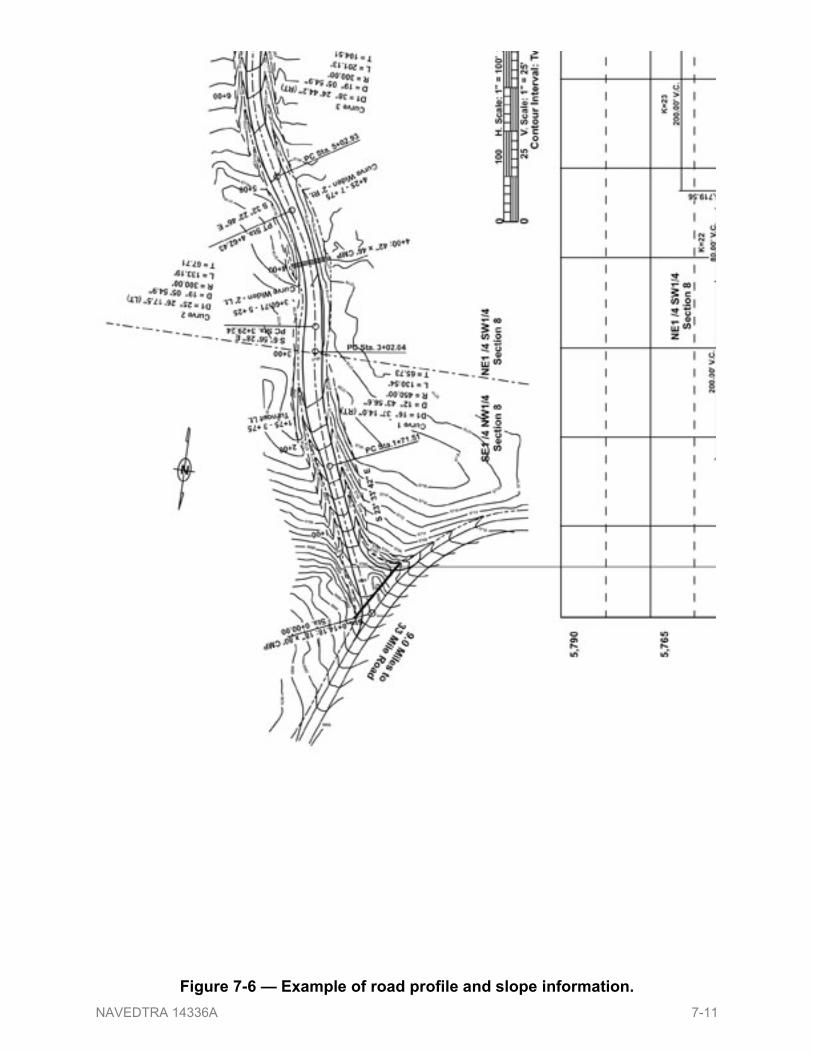
Figure 7-6 mdash Example of road profile and slope information NAVEDTRA 14336A 7-11
A road grade line represented by a heavy solid line is also drawn on the lower portion of the plan-and-profile paper Like the profile the grade line is a longitudinal section taken along the centerline and shows the elevations to which the road is built Normally the grade line is the centerline elevations of the finished surface but on occasion it may be the centerline elevations of the subgrade If you use the subgrade you must make a special note of it The grade lines are a series of straight lines connected where necessary by curves (called vertical curves mdash the next topic) They may be level or sloped if sloped upward the grade is positive if downward the grade is negative The slopes are in reference to the direction of increasing stations The amount of slope is lettered above the grade line and is usually indicated as the percent of slope Note the slopes in Figure 7-6 In this example the slopes continuously change from +1041 grade at 175rsquo through a ndash264 at 375rsquo and then a slight rise of +094 at 415rsquo to a +950 grade increase at 675rsquo This means the centerline grade lowers or raises a total of 3593 feet in a 675 foot horizontal distance At vertical curves the straight lines are tangents that intersect at a point called the point of vertical intersection (PVI) This point is comparable to the PI of horizontal curves
NOTE Some agencies use similar but slightly different terminology as shown in Figures 7-6 For example
VPI = Vertical Point of Intersection VPC = Vertical Point of Curvature VPT = Vertical Point of Tangency
141 Vertical Curves To offer safe comfortable driving conditions the PVI should not break sharply The length of the curve depends upon the steepness of the intersecting grades Note in Figure 7-6 that the PVIs are centered on 20000prime 8000prime and 20000prime VC (vertical curvatures) The station on which the curve begins and ends is called the point of vertical curvature (PVC) and point of vertical tangency (PVT) respectively Unlike the length of a horizontal curve (which is a measured distance following the curve) the length of a vertical curve is the straight-line horizontal distance from the beginning to the end of the curve or from PVC to PVT A vertical curve at the crest or top of a hill is called a summit curve or oververtical one at the bottom of a hill or a dip is called a sag curve or undervertical Vertical curves may be symmetrical meaning the tangent length from PVC to PVI equals the tangent length from PVI to PVT though it is not necessary for the PVC and the PVT to be at the same elevation to have a symmetrical vertical curve However some situations may dictate that an unsymmetrical vertical curve (a parabolic with no constant radius) will better satisfy constraints An unsymmetrical curve is a curve in which the tangent length from PVC to PVI does not equal the tangent length from PVI to PVT Therefore the curves are plotted usually in 50-foot lengths by computing the offsets from the two tangents Definitions and formulas for symmetrical and unsymmetrical vertical curves can be found in EA Advanced Chapter 3 NAVEDTRA 14336A 7-12
142 Drawing the Grade lines Use the same horizontal and vertical scale to draw both the grade line and the profile this allows the measurement of cuts or fills for a particular point If the grade line is higher than the profile fill is required if lower cut is required Refer again to Figure 7-6 Show the relative locations of drainage structures such as box culverts and pipes on both the profile and grade line drawings However use only the vertical scale to draw these structures You can plot the heights of the structures accurately using the vertical scale but you cannot draw the width of the structures to scale because of the exaggerated difference between the vertical and horizontal scales Draw the width of the structures just wide enough to indicate the type of structure show a box culvert as a high narrow rectangle and a round pipe as a high narrow ellipse
150 Road Dimensions Dimensioning for road plans is a variation of standard dimensioning In road dimensioning numerical values for elevations cuts fills and stations are also considered dimensions Most road dimensions appear on the profile and grade line drawing as shown in Figure 7-7
NAVEDTRA 14336A 7-13
Figure 7-7 mdash Example of profile grade line with cut and fill calculations NAVEDTRA 14336A 7-14
Refer to Figure 7-7 for the following explanations and guidance
bull Station Numbers mdash Letter station numbers horizontally below profile and grade line centered on the appropriate vertical grid line
bull Elevations (profile and grade line) mdash Letter elevations vertically at the bottom for each station o Grade line elevations are lettered just above profile elevations Any station
numbers other than full stations are noted vertically as plus (+) stations just outside the bottom border
bull Cuts and Fills mdash Letter cuts and fills vertically at the bottom above the profile and grade line elevations o Indicate grade-points (where profiles cross grade lines) by the word GRADE
lettered vertically above the grade-point station
bull Ditches mdash Dimensioning ditches requires two steps 1 Draw extension lines downward from the ends of a ditch or any point in the
ditch where the ditch grade changes and draw dimension lines with heavy arrowheads between them These extension and dimension lines need to be drawn heavier than normal to be distinguished from grid lines
2 Letter the ditchrsquos information above the dimension line if crowded use the space below the line Furnish the following information o Percent of grade o Depth relative to centerline o Type o Width o Elevation and station at ends and changes of grade
bull Vertical Curves mdash Draw extension lines upward from the PVC and PVT add a dimension line arrowheads and above letter the length of the curve Letter vertically the station and elevation of the PVC PVI and PVT
bull Correlation with Plan mdash Match all points on the profile and grade line with centerline points on the road plan such as the beginning and ending of construction with lettering indicating the elevations at these points
bull Drainage Structures mdash Dimension all drainage structures such as pipes and culverts with notes providing station number size of opening length of pipe and flow-line elevation
bull Title mdash In Figure 7-7 the title ldquoPROFILE amp GRADELINErdquo along with horizontal and vertical scales is lettered below the drain structure and ditch dimensions
NAVEDTRA 14336A 7-15
160 Sequence of Construction Construction crews follow a specific sequence when building a road
1 Clear the roadrsquos through area of trees stumps brush boulders and other debris (known as clearing and grubbing) shown in Figure 7-8
The width of the clearing varies greatly but should always be at least 12 feet greater than the roadway width that is 6 feet beyond the construction limit on each side
Figure 7-8 mdash Example of clearing and grubbing
2 Lay cross-drain pipes or culverts and commence grading operations by Equipment Operators (Figure 7-9)
In fill areas bring grade up in successive layers with compaction In cuts areas excavate until reaching subgrade then compact Throughout this step workers place culverts at the appropriate slopes when and where required according to the roadway plans
Figure 7-9 mdash Example of placing pipe and grading
NAVEDTRA 14336A 7-16
3 Place a base course on the subgrade The base course material can be gravel sand crushed stone or more expensive and permanent materials (Figure 7-10)
4 Place a surface course over the base This material can be sand asphalt blacktop concrete or similar materials
Figure 7-10 mdash Example of placing a base course of crushed stone
Depending on the location and intended permanency of the road traffic may be allowed to travel over the subgrade itself In other instances traffic may require only a gravel or stone surface However a high-speed road requires a base and a hard durable surface
170 Sections A section is a view of an object cut by a plane perpendicular to the line of sight For road design and construction a section is perpendicular to the roadway centerline Sections are used for a variety of purposes during road design and construction two of which are to define the materials to be used and communicate the design configuration of the completed road Sections are also used to stake out roads determine earthwork requirements and provide quality control in determining how the completed road conforms to its original design
171 Typical Section The shape and features of a road should be as uniform as possible while still meeting the projectrsquos conditions and requirements Typical sections establish that standard of uniformity The typical sections of a road show exactly what the road should look like in appropriate segments upon completion It includes the type and thickness of the base and surface materials the crown superelevation ditch slope cut slope fill slope and all horizontal widths of components such as surface shoulders and ditches (Figure 7-11)
NAVEDTRA 14336A 7-17
Figure 7-11 mdash Example of a typical section Slight deviations will occur during construction and tolerances are allowed However the shape and construction of the road should conform as closely as possible to the typical section Refer to United Facilities Criteria UFC 3-250-12N Design Pavements and UFC 3-250-1FA Pavement Design for Roads Streets Walks and Open Storage Areas for additional information on general provisions and design criteria The roadbed for the curved portion differs from the roadbed for the straight portion so typical sections are prepared for both A typical section for a curve will show the pavement as a plane surface instead of crowned and it is usually superelevated to account for centrifugal force encountered in curves The outside shoulder slope is the same as the superelevated pavement slope but the inside shoulder slope (closest to the center of the arc) is either the same or a greater slope Most curves are also widened on the inside to allow for the ldquocurve straighteningrdquo effect of long wheelbase vehicles On a tractor-trailer rig the trailerrsquos wheels do not follow the tracks of the tractorrsquos wheels They run closer to the inside edge on the inside lane and closer to the centerline on the outside lane presenting a safety hazard when two vehicles meet on curves Curve widening partially relieves this hazard Figure 7-12 shows a superelevated section with curve widening You can find specific guidance for curve widening in the previously mentioned UFCs
NAVEDTRA 14336A 7-18
Figure 7-12 mdash Example of typical curve section
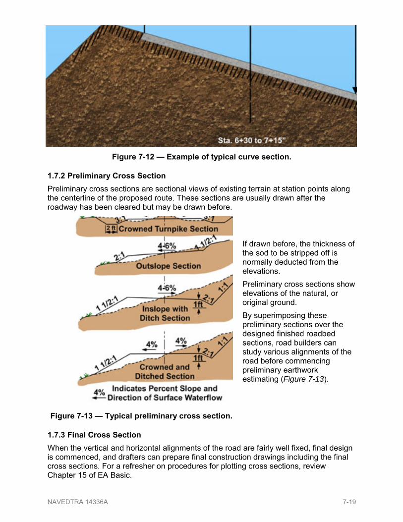
172 Preliminary Cross Section Preliminary cross sections are sectional views of existing terrain at station points along the centerline of the proposed route These sections are usually drawn after the roadway has been cleared but may be drawn before
If drawn before the thickness of the sod to be stripped off is normally deducted from the elevations Preliminary cross sections show elevations of the natural or original ground By superimposing these preliminary sections over the designed finished roadbed sections road builders can study various alignments of the road before commencing preliminary earthwork estimating (Figure 7-13)
173 Final Cross Section When the vertical and horizontal alignments of the road are fairly well fixed final design is commenced and drafters can prepare final construction drawings including the final cross sections For a refresher on procedures for plotting cross sections review Chapter 15 of EA Basic
NAVEDTRA 14336A 7-19
Figure 7-14 mdash Example of road with major drainage problem
From these final cross sections crews can set slope stakes at each station along the centerline of the road They show the actual shape of the road the horizontal width of components their distances from the centerline finish elevations and the extremities of the cut and fill They also show the slopes of the roadbed surface ditches and shoulders The term final cross section also applies to the as-built sections established after the road is completed
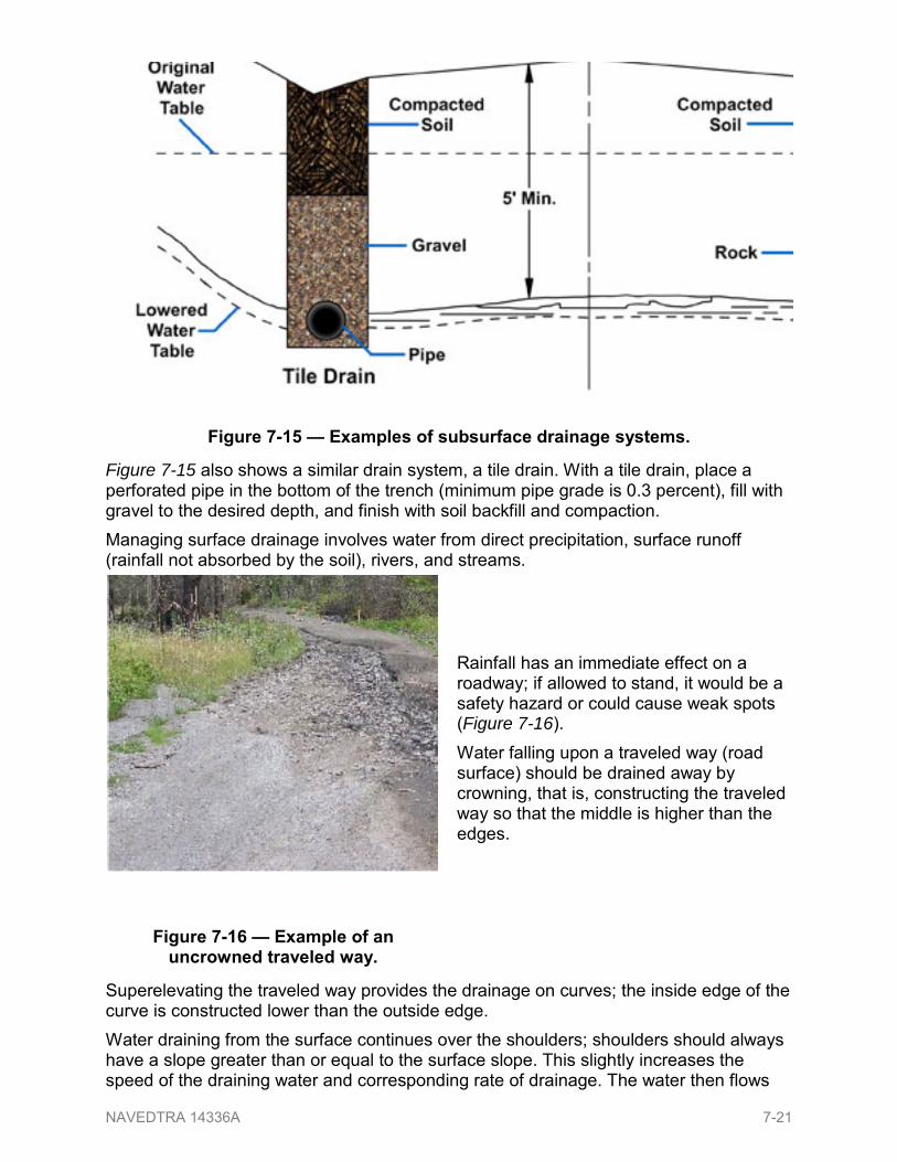
180 Drainage Drainage can be a major problem in the location construction and design of roads A route should never be located where drainage cannot be handled or would be too costly to handle (Figure 7-14) Swamps underground springs flash floods and seasonal high floodwaters that can cover the road are causes to relocate a proposed route and provide good reasons for planning alternate routes A route may also have to be relocated because local material is insufficient to build a particular type of road To prevent standing puddles on the roadway during construction some surface drainage problems can be solved by slanting the worked surface so water will run off quickly or by cutting ditches called bleeders so the water is carried away Solving subsurface drainage problems requires either raising the grade line of the road or lowering the water table In either case the elevation difference between the water table and the top of the subgrade should be as great as possible One way to lower the water table is to dig deep open ditches that are set back beyond the roadway limits These deep ditches allow groundwater to seep through the sides intercepting and directing the flow out to the end of each ditch Another way is to dig a deep trench exactly where the finished roadway ditch will be backfill it to a designated depth with rocks or large gravel of varying sizes (larger sizes at the bottom) cap the rocks with a layer of branches or straw and finish with soil backfill and compaction This type of drain is a french drain (Figure 7-15)
NAVEDTRA 14336A 7-20
Figure 7-15 mdash Examples of subsurface drainage systems
Figure 7-15 also shows a similar drain system a tile drain With a tile drain place a perforated pipe in the bottom of the trench (minimum pipe grade is 03 percent) fill with gravel to the desired depth and finish with soil backfill and compaction Managing surface drainage involves water from direct precipitation surface runoff (rainfall not absorbed by the soil) rivers and streams
Rainfall has an immediate effect on a roadway if allowed to stand it would be a safety hazard or could cause weak spots (Figure 7-16) Water falling upon a traveled way (road surface) should be drained away by crowning that is constructing the traveled way so that the middle is higher than the edges
Figure 7-16 mdash Example of an uncrowned traveled way
Superelevating the traveled way provides the drainage on curves the inside edge of the curve is constructed lower than the outside edge Water draining from the surface continues over the shoulders shoulders should always have a slope greater than or equal to the surface slope This slightly increases the speed of the draining water and corresponding rate of drainage The water then flows
NAVEDTRA 14336A 7-21
from the shoulder down the side of the fall in a fill section or into a roadway ditch in a cut section Roadway ditches are not normally used in a fill section
181 Roadway Ditches
There are three main types of ditches used in road and airfield construction side (or roadway) interceptor and diversion A properly functioning roadway ditch is the most important factor in roadway drainage Running alongside the traveled way if the ditch is inadequate for the volume of water or becomes obstructed the overflow can flood the roadbed to block traffic andor wash away surface and shoulder material (Figure 7-17)
Figure 7-17 mdash Example of an inadequate ditch eroding shoulder material
You need to consider a number of factors in determining the size and type of roadway ditches such as
bull volume of water to be carried
bull slope of the back slope
bull soil types
bull ldquolay of the landrdquo
bull maximum and minimum ditch grades The slopes of the surface shoulders and back slopes affect the volume A steep slope increases the rate of runoff which causes a greater instantaneous volume of water in the ditch A shallower slope decreases the rate of runoff but exposes more surface area on the back slope which increases the amount of runoff However other factors predominately affect the choice of slope
bull Is additional excavation needed
bull If so what type of soil would form the ditch If the ditch cut will be in sand it will require a lesser slope than if in clay or rock All soil types have different amounts of runoff runoff from sandy soil is small while runoff from clay soil or solid rock is large
NAVEDTRA 14336A 7-22
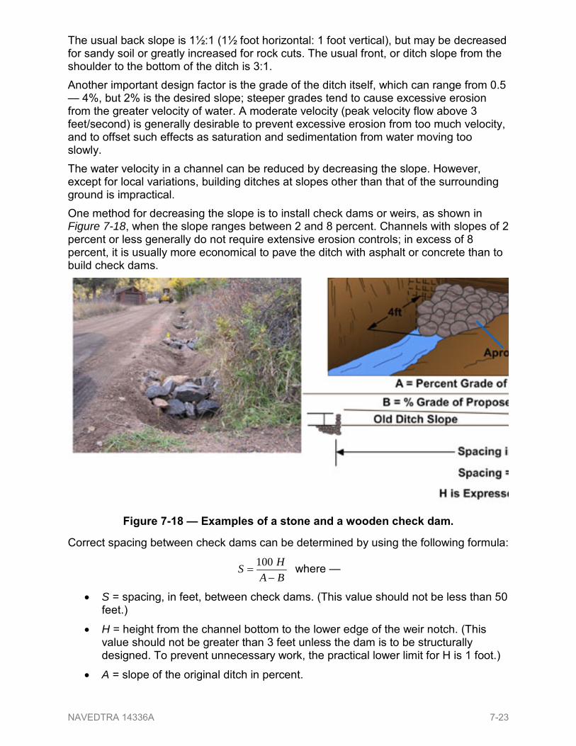
The usual back slope is 1frac121 (1frac12 foot horizontal 1 foot vertical) but may be decreased for sandy soil or greatly increased for rock cuts The usual front or ditch slope from the shoulder to the bottom of the ditch is 31 Another important design factor is the grade of the ditch itself which can range from 05 mdash 4 but 2 is the desired slope steeper grades tend to cause excessive erosion from the greater velocity of water A moderate velocity (peak velocity flow above 3 feetsecond) is generally desirable to prevent excessive erosion from too much velocity and to offset such effects as saturation and sedimentation from water moving too slowly The water velocity in a channel can be reduced by decreasing the slope However except for local variations building ditches at slopes other than that of the surrounding ground is impractical One method for decreasing the slope is to install check dams or weirs as shown in Figure 7-18 when the slope ranges between 2 and 8 percent Channels with slopes of 2 percent or less generally do not require extensive erosion controls in excess of 8 percent it is usually more economical to pave the ditch with asphalt or concrete than to build check dams
Figure 7-18 mdash Examples of a stone and a wooden check dam
Correct spacing between check dams can be determined by using the following formula
BAHS
minus=
100 where mdash
bull S = spacing in feet between check dams (This value should not be less than 50 feet)
bull H = height from the channel bottom to the lower edge of the weir notch (This value should not be greater than 3 feet unless the dam is to be structurally designed To prevent unnecessary work the practical lower limit for H is 1 foot)
bull A = slope of the original ditch in percent
NAVEDTRA 14336A 7-23
bull B = desired slope in percent (This value should be set at 2 percent This is the maximum slope that will not require additional erosion control)
Example Original slope = 6 Desired slope = 2 Height = 3 ft Find S = spacing
feetBAHS 75
4300
26)3(100100
==minus
=minus
=
Rainfall itself of course is the one factor involving water volume that cannot be controlled the more intense the rainfall or the longer the duration the greater the volume of water the ditch has to carry However gathering information from local residents and observing high-water marks along streams can help the engineer determine the heaviest rainfall to expect in a particular area In addition to considering soil type slopes and volume of water as factors the engineer must also consider available equipment and traffic usage when designing the type of ditch to use A grader is best suited to cut ldquoVrdquo or triangular ditches while a scraper is best suited for an expedient wide flat bottomed or trapezoidal ditch Besides inviting excessive erosion sidewalls designed and cut too deep can turn minor ldquooff the roadrdquo accidents into something more serious by a vehicle overturning and entrapping the occupants The two most common types of ditches are the V-bottom and the flat bottom or trapezoidal ditches Under similar conditions water flows faster in a V-bottom ditch than in a trapezoidal ditch The most common ditches and their typical side slopes are shown in Figure 7-19 For a trapezoidal ditch the flat bottom is generally 2 feet wide but can range anywhere from 1 foot to scraper width
Figure 7-19 mdash Example of the most common types of ditches and slopes
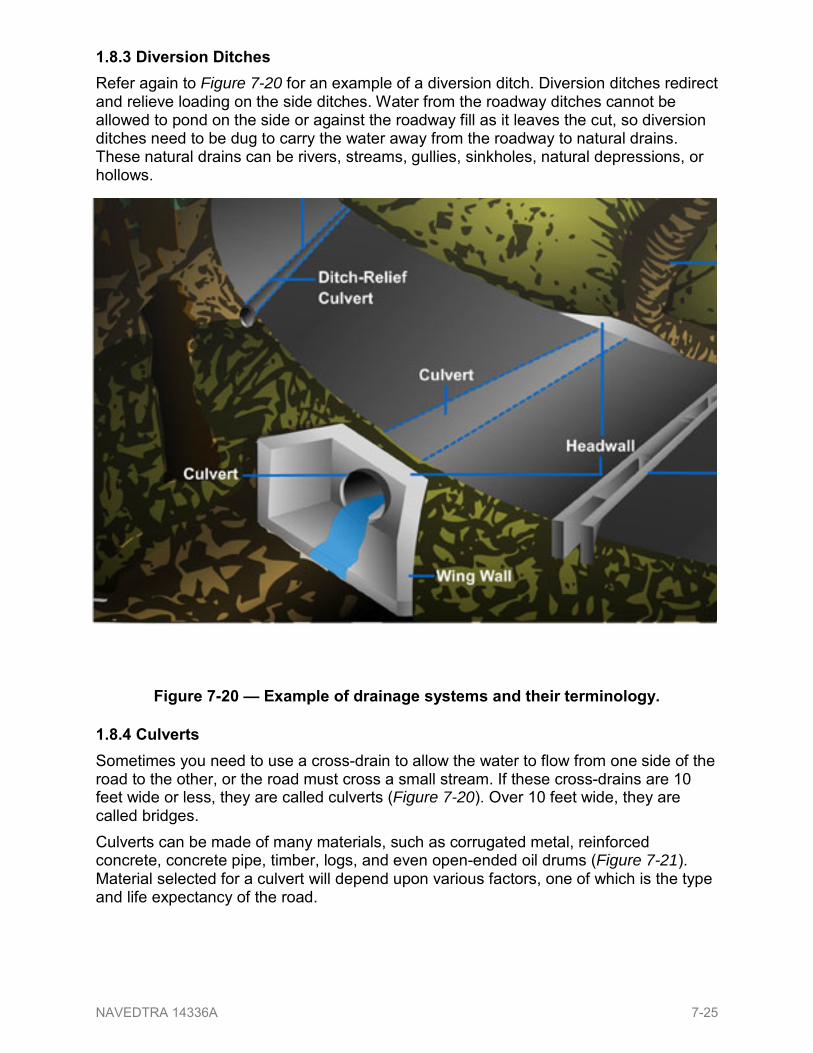
182 Interceptor Ditches Interceptor ditches can decrease the volume of water draining into a roadway ditch These are shallow ditches dug around the top of the cut to intercept and redirect the water draining from the original ground toward the roadway Figure 7-20 shows an interceptor ditch 10 to 12 feet above the back slope limits The quantity and size of needed interceptor ditches will depend on the original ground slope runoff area type of soil vegetation and any other factors related to runoff volume
NAVEDTRA 14336A 7-24
183 Diversion Ditches Refer again to Figure 7-20 for an example of a diversion ditch Diversion ditches redirect and relieve loading on the side ditches Water from the roadway ditches cannot be allowed to pond on the side or against the roadway fill as it leaves the cut so diversion ditches need to be dug to carry the water away from the roadway to natural drains These natural drains can be rivers streams gullies sinkholes natural depressions or hollows
Figure 7-20 mdash Example of drainage systems and their terminology
184 Culverts Sometimes you need to use a cross-drain to allow the water to flow from one side of the road to the other or the road must cross a small stream If these cross-drains are 10 feet wide or less they are called culverts (Figure 7-20) Over 10 feet wide they are called bridges Culverts can be made of many materials such as corrugated metal reinforced concrete concrete pipe timber logs and even open-ended oil drums (Figure 7-21) Material selected for a culvert will depend upon various factors one of which is the type and life expectancy of the road
NAVEDTRA 14336A 7-25
Figure 7-21 mdash Examples of expeditionary culverts
For permanent roads and highways with concrete or asphalt paving reinforced concrete or concrete pipe should be used Concrete pipe is one of the strongest and most durable materials used in manufacturing culverts The pipe diameter is in direct proportion to the shell thickness and length the larger the diameter the thicker the shell and the longer the section availability Pipe diameters are nominal inside dimensions For semi-permanent and temporary or expeditionary roads the design engineer may choose to use materials such as or similar to those shown in Figure 7-21
Test your Knowledge (Select the Correct Response)1 As a senior EA your involvement in road construction can include ________
A conducting surveying operations B assisting in the design C providing on-site construction quality control D all of the above
200 AIRFIELDS Road construction and airfield construction are similar in methods equipment and sequence of operations both require a subgrade base course and surface course Clearing and grubbing cutting and filling grading and compacting surfacing all these basic evolutions are common to both types of projects NAVEDTRA 14336A 7-26
Since the engineering officer is also responsible for designing and laying out an airfield as a senior EA you can expect to be involved in this project as well This section will introduce you to airfields and airfield terminology
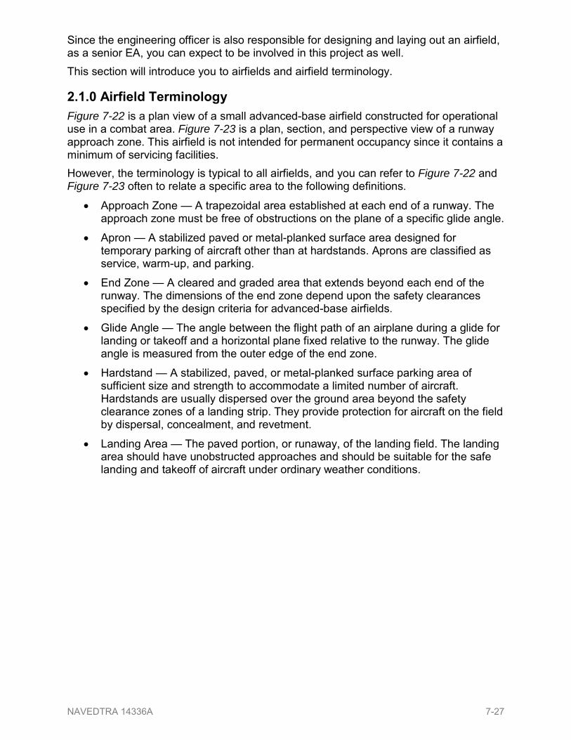
210 Airfield Terminology Figure 7-22 is a plan view of a small advanced-base airfield constructed for operational use in a combat area Figure 7-23 is a plan section and perspective view of a runway approach zone This airfield is not intended for permanent occupancy since it contains a minimum of servicing facilities However the terminology is typical to all airfields and you can refer to Figure 7-22 and Figure 7-23 often to relate a specific area to the following definitions
bull Approach Zone mdash A trapezoidal area established at each end of a runway The approach zone must be free of obstructions on the plane of a specific glide angle
bull Apron mdash A stabilized paved or metal-planked surface area designed for temporary parking of aircraft other than at hardstands Aprons are classified as service warm-up and parking
bull End Zone mdash A cleared and graded area that extends beyond each end of the runway The dimensions of the end zone depend upon the safety clearances specified by the design criteria for advanced-base airfields
bull Glide Angle mdash The angle between the flight path of an airplane during a glide for landing or takeoff and a horizontal plane fixed relative to the runway The glide angle is measured from the outer edge of the end zone
bull Hardstand mdash A stabilized paved or metal-planked surface parking area of sufficient size and strength to accommodate a limited number of aircraft Hardstands are usually dispersed over the ground area beyond the safety clearance zones of a landing strip They provide protection for aircraft on the field by dispersal concealment and revetment
bull Landing Area mdash The paved portion or runaway of the landing field The landing area should have unobstructed approaches and should be suitable for the safe landing and takeoff of aircraft under ordinary weather conditions
NAVEDTRA 14336A 7-27
Figure 7-22 mdash Example of an advanced-base airfield and terminology NAVEDTRA 14336A 7-28
Figure 7-23 mdash Example of a runway approach zone and terminology NAVEDTRA 14336A 7-29
bull Landing Strip mdash The area that includes the landing area end zones shoulders and cleared areas
bull Revetment mdash A protective pen usually made by excavating into the side of a hill or by constructing earth timber sandbag or masonry traverse around the hardstands Such pens provide protection against bomb fragments from high-altitude bombing but provide little protection against ground strafing They may actually draw this type of fire if not well concealed
bull Runway mdash The portion of the landing strip usually paved used for the landing and takeoff of aircraft
bull Shoulder mdash The graded and stabilized area adjacent to the runway or taxiway Although it is made capable of supporting aircraft and auxiliary equipment (such as crash trucks) in emergencies its principal function is to facilitate surface drainage
bull Taxiway mdash A specially prepared area over which aircraft may taxi to and from the landing area
bull Transition Surface mdash A sloping plane surface (about 1 foot rise to 7 feet run) at the edge of a landing strip Its function is to provide lateral safety clearances for planes that accidentally run off the strip
220 Planning an Airfield Planning for aviation facilities requires special consideration
bull type of aircraft to be accommodated
bull physical conditions of the site o weather conditions o terrain o soil
bull availability of construction materials
bull safety factors o approach zone obstructions o traffic control
bull provision for expansion
bull defense Wartime conditions also require tactical considerations All of these factors affect the number orientation and dimensions of runways taxiways aprons hardstands hangars and other facilities For additional information about airfield planning and construction refer to the Unified Facilities Criteria UFC 3-260-XX series mdash01 Airfield and Heliport Planning and Design mdash02 Pavement Design for Airfields mdash03 Airfield Pavement Evaluation
300 SUBBASE and BASE COURSE Pavements (including the surface and underlying courses) may be divided into two classesmdashrigid and flexible The wearing surface of a rigid pavement consists of Portland NAVEDTRA 14336A 7-30
cement concrete with strength that enables it to act as a miniature beam to bridge over minor irregularities in the base or subgrade material All other pavements are classified as flexible Distortions or displacements in the subgrade reflect into the base course and upward into the surface course Under traffic loading the layered courses tend to conform to the same shape Flexible pavements are used almost exclusively in the theater of operations for road and airfield construction they are adaptable to nearly all situations and any construction battalion in the Naval Construction Force (NCF) can build them
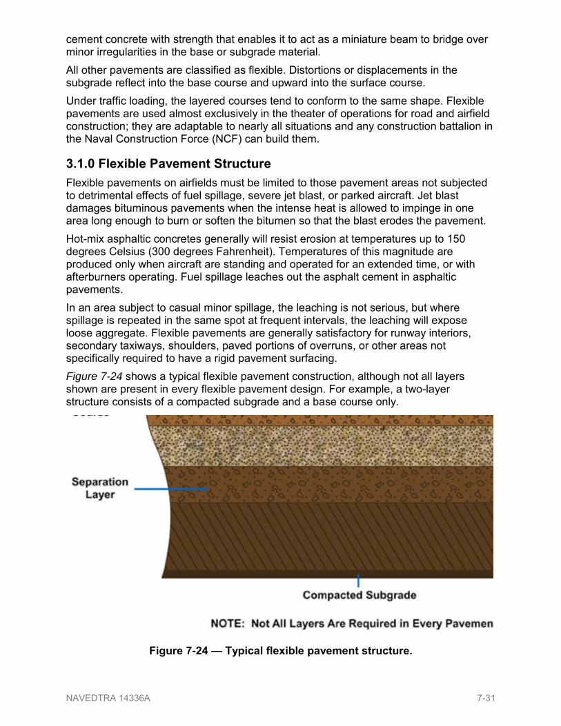
310 Flexible Pavement Structure Flexible pavements on airfields must be limited to those pavement areas not subjected to detrimental effects of fuel spillage severe jet blast or parked aircraft Jet blast damages bituminous pavements when the intense heat is allowed to impinge in one area long enough to burn or soften the bitumen so that the blast erodes the pavement Hot-mix asphaltic concretes generally will resist erosion at temperatures up to 150 degrees Celsius (300 degrees Fahrenheit) Temperatures of this magnitude are produced only when aircraft are standing and operated for an extended time or with afterburners operating Fuel spillage leaches out the asphalt cement in asphaltic pavements In an area subject to casual minor spillage the leaching is not serious but where spillage is repeated in the same spot at frequent intervals the leaching will expose loose aggregate Flexible pavements are generally satisfactory for runway interiors secondary taxiways shoulders paved portions of overruns or other areas not specifically required to have a rigid pavement surfacing Figure 7-24 shows a typical flexible pavement construction although not all layers shown are present in every flexible pavement design For example a two-layer structure consists of a compacted subgrade and a base course only
Figure 7-25 shows a typical all-bituminous concrete pavement However UFC 3-26-02 Pavement Design for Airfields does not recommend this type of pavement for Navy airfields
Figure 7-26 shows a typical flexible pavement using stabilized layers As mentioned previously flexible pavements are generally satisfactory for runway interiors taxiways shoulders and overruns
NOTE The word pavement when used by itself refers only to the leveling binder and surface course whereas flexible pavement refers to the entire pavement structure from the subgrade up
Figure 7-26 mdash Typical flexible pavement with stabilized base
NAVEDTRA 14336A 7-32
Figure 7-27 shows a typical rigid pavement structure The following pavements will be rigid pavement
bull all paved areas on which aircraft or helicopters are regularly parked maintained serviced or preflight checked on hangar floors and access aprons
bull specific runway ends bull any other area where it
can be documented that flexible pavement will be damaged by jet blast or by spillage of fuel or hydraulic fluid
320 Materials Select materials will normally be the locally available coarse-grained soils although in certain cases the design may call for fine-grained soils When they are economically available on the local market the designing officer may consider lime rock coral shell ashes cinders caliche disintegrated granite and other like materials
321 Subbase Subbase materials may consist of naturally occurring coarse-grained soils or blended and processed soils When they meet area specifications or project specifications the previously mentioned materials may be used as subbases In certain instances it may be more economical to use materials stabilized with commercial admixes for subbases Portland cement cutback asphalt emulsified asphalt and tar are commonly used for this purpose
322 Base Course A base coursersquos material design may call for a wide variety of gravels sands gravelly and sandy soils or other natural materials either alone or blended Some natural materials may only need crushing or removal of the oversize fraction to maintain gradation limits while others may require mixing crushed and pit-run materials to form material for a satisfactory base course Many natural deposits of sandy and gravelly materials make satisfactory base materials but they vary widely in their relative proportions of coarse and fine material and in the character of their rock fragments Often however blending materials from two or more deposits can produce satisfactory base materials To support heavy loads you can use a base course made from sandy and gravelly material with its high-bearing value but you should not use uncrushed clean-washed
NAVEDTRA 14336A 7-33
gravel Clean-washed gravel is not satisfactory for a base course since the fines which act as the binder and void filler to the coarse aggregate have been washed away Alluvial deposits in thickness from 1 to 20 feet may contain sand and clay in a natural mixture but typically there are great variations in the sandclay proportions from the top of a pit to the bottom Do not confuse unacceptable deposits of partially disintegrated rock with fragments of rock clay and mica flakes with acceptable sand-clay soils Mistaking such material for sand-clay soil is often the reason for a base course failure the reduced stability caused by the mica content Nevertheless with proper proportioning and construction methods sand-clay soil can achieve satisfactory results it is excellent material for construction where a higher type of surface will be added later Processed materials are prepared by crushing and screening rock gravel or slag and a properly graded crushed-rock base can make the highest quality of any base material providing it is produced from sound durable rock particles Almost any rock hard enough to require drilling blasting and crushing can produce a satisfactory crushed-rock material The usual resources for raw processing material are existing quarries ledge rock cobbles and gravel talus deposits coarse mine tailings or other similar hard durable rock fragments Do not use materials that crumble on exposure to air or water Nor should you use processed materials when gravel or sand-clay is available except when the project requirements make it necessary or when studies show that processed materials will save time and effort Bases made from processed materials can be divided into three general types stabilized coarse-graded and macadam
bull Stabilized base mdash All material ranging from coarse to fine is intimately mixed either before or as the material is laid into place
bull Coarse-graded base mdash Composed of crushed rock gravel or slag this base may be used to advantage when necessary to produce crushed rock gravel or slag on site or when commercial aggregates are available
bull Macadam base mdash Coarse crushed aggregate is placed in a relatively thin layer and rolled into place then fine aggregate or screenings are placed on the surface of the coarse-aggregate layer and rolled into the coarse rock until it is thoroughly keyed in place Water may be used in the compacting and keying process then the base is a water-bound macadam Crushed rock used for macadam bases should consist of clean angular durable particles free of clay organic matter and other objectionable material or coating Any hard durable crushed aggregate is usable provided the coarse aggregate is primarily one size and the fine aggregate will key into the coarse aggregate
323 Other Materials In a theater of operations where natural deposits of sand gravel or sources of crushed rock are unavailable base courses can be developed from materials not normally considered such as coral caliche tuff rubble lime rock shells cinders iron ore and other select materials Some are primarily a soft rock that is crushed or degraded under construction traffic to produce a composite base material others develop a cementing action resulting in a satisfactory base The following describes the characteristics and usage of some of these materials NAVEDTRA 14336A 7-34
3231 Coral Uncompacted and poorly drained coral often results in an excessive moisture content and loss of stability Coralrsquos greatest asset as a construction material is its bonding properties but those properties can fluctuate greatly with a number of variables
bull quantity of volcanic impurities
bull proportion of fine and coarse material
bull age
bull length of exposure to the elements
bull climate
bull traffic
bull sprinkling
bull method of compaction However with additional attention to proper moisture control drainage and compaction methods coral can obtain satisfactory results
3232 Caliche Caliche is another variable material consisting of sand silt or even gravel Its variability in content (limestone silt and clay) and in degree of cementation make it essential that caliche be obtained from deposits of good uniform quality and that it be compacted at optimum moisture When properly saturated with water compacted and allowed to settle caliche can be made into high-quality base courses especially caliches that are cemented with lime iron oxide or salt
3233 Tuff Tuff is a porous rock usually stratified and formed by consolidation of volcanic ashes dust and other cementatious materials of volcanic origin It may be used for constructing base courses the same as other base courses except that after tuff is dumped and spread the oversize pieces need to be broken and compacted with sheepsfoot rollers The surface is then graded compacted and finished
3234 Rubble Debris or rubble from destroyed buildings may also be used to advantage in constructing base courses Depending on theater operations multiple goals may be achieved by reusing building materials clearance of building rubble disposal of accumulated rubble resource for a base course non-use or minimized use of other natural resources If debris or rubble from destroyed buildings is designated for use jagged pieces of metal and similar objects must be removed
324 Bituminous Base When an asphalt mixing plant and bituminous materials are readily available bituminous base courses may be used to advantage if locally available aggregates are relatively soft or of relatively poor quality Bituminous mixtures are frequently used as base courses beneath high-type bituminous pavements when the design calls for a relatively thick surface course for traffic particularly for rear-areas which carry heavy traffic
NAVEDTRA 14336A 7-35
Generally a bituminous base course may be considered equal to other types of high-quality base courses on an inch-for-inch basis but if a bituminous base course is used it must be placed in lifts not exceeding 3 12 inches in thickness Additionally if using a bituminous base the binder course may be omitted and the surface course may be laid directly on the base course
Summary Whether the construction involves military roads or airfields you can expect to be a participant in one of the many roles an Engineering Aid may be tasked with during a unitrsquos project You can best serve yourself and your unit by knowing and understanding the general methodology of horizontal construction the terminology of both roadway and airfield construction and the use and development of resource materials to construct both
NAVEDTRA 14336A 7-36
Review Questions (Select the Correct Response)1 Which of the following is NOT an example of a military road
A Two-lane highway B Expedient jungle path C Parking apron D Quarry hauling road
When answering questions 2 through 5 refer to the table below
1 Cut 2 Final Grade 3 Existing Grade 4 Fill 5 Subgrade 6 Surface
2 What term describes the completed road surface elevation
A 2 B 3 C 5 D 6
3 What term describes the undisturbed earth on an initial survey
A 2 B 3 C 5 D 6
4 What term describes the distance required to get down to the final grade
A 1 B 2 C 4 D 6
5 What term describes the portion of the road that is at final grade
A 3 B 4 C 5 D 6
NAVEDTRA 14336A 7-37
6 What term best describes the difference in elevation between the edge of the finished road and the centerline
A Slope ratio B Superelevation C Crown D Roadway
7 What term defines the limits of the earthwork for a road
A Roadbed B Shoulder C Traveled way D Roadway
8 What is the minimum information needed by a survey crew to perform the
preliminary route survey
A Selected route B Aerial photographs C Area topography D Plan-and-profile sheet
9 By what name is the drawing known that contains construction limits station
markings and all curve information
A Profile plan B Road plan C Plan-and-profile sheet D Site plan
10 As the note taker on a road survey crew in what manner should you note all
man-made objects in the book
A By station number only B By distance from the centerline only C By station number and distance from the centerline D By the approximate location and distance
11 ldquoSuperelevationrdquo is defined as the difference in elevation between the _____
A centerline and the outside edge B centerline and the inside edge C inside edge and the outside edge D PC and the PT
12 (True or False) A road profile is a vertical section along the centerline
A True B False
NAVEDTRA 14336A 7-38
13 Which of the following values may vertical curves have
A Positive only B Negative only C Positive or negative
14 (True or False) A grade line may represent final elevation or subgrade elevation
A True B False
15 What type of curve is a vertical curve at the crest of a hill
A Sag B Undervertical C Overhead D Summit
16 What term is used to designate grade points in a road plan
A Station B Profile C Elevation D Grade
17 In what manner are station numbers (a) lettered and (b) located on a road plan
A (a) Horizontally above the profile (b) right of the appropriate vertical grid line
B (a) Horizontally below the profile (b) left of the appropriate vertical grid line C (a) Horizontally above the profile (b) centered on the appropriate vertical
grid line D (a) Horizontally below the profile (b) centered on the appropriate vertical
grid line 18 In a profile and grade line drawing all drainage structures are dimensioned by
_____
A station B type C detail D notes
19 How much greater than construction limits is the minimum clearing width in feet
on the left side of the roadway
A 5 B 6 C 10 D 12
NAVEDTRA 14336A 7-39
20 Which of the following materials may be used as a base course in road construction
A Sand B Gravel C Concrete D All of the above
21 The surface course is placed over the _____
A base B subgrade C subbase D roadbed
22 A typical section view of a road shows exactly what it will look like _____
A before construction begins B at a specific segment upon completion C overall after construction D at station 0 + 00 and the final station only
23 In what way if any does a typical straight road section differ from a typical curve
section
A Shape of the road only B Width of the road only C Shape and width of the road D Neither they are the same
24 What type of cross section will be drawn first from the notes after you have
completed a route survey
A Preliminary B Final C Typical D As-built
25 Preliminary cross sections are used in conjunction with _____ sections to _____
A final determine as-built conditions B as-built determine construction errors C typical determine existing material usefulness D designed finished roadbed determine earthwork requirements
26 Which of the following information does a final cross-section view show
A Finished elevation B Actual cross-sectional shape of the curves C Distances of ditches from the centerline D All of the above
NAVEDTRA 14336A 7-40
27 When if ever should a route be relocated due to drainage problems
A When planned through a forest B When located in a floodplain C When underground springs are a mile away D Never
28 Which if any of the following actions should be taken during road construction to
prevent standing puddles on the roadway
A Slant the worked surface of the road to provide quicker runoff B Cut ditches outside the construction limits C Raise the final grade of the roadway D None of the above
29 What term is used for a perforated pipe placed in the bottom of a trench and
backfilled to a designated depth to lower the water table
A French drain B Trenching C Bleeders D Tile drain
30 What is the minimum grade allowed in feet for a 50-foot ditch for subsurface
drainage
A 010 B 015 C 025 D 030
31 Which if any of the following effects does rainfall have on a roadway
A Cleans the road surface B Erodes the roadway C Weakens road if allowed to stand D None of the above
32 What term best describes a centerline elevation that is 025 feet higher than the
edge of the road
A Superelevation B Drainage C Ditching D Crown
NAVEDTRA 14336A 7-41
33 Which of the following factors should you consider when determining the size and type of roadway ditches
A Soil types B Lay of the land C Volume of water D All of the above
34 Which of the following conditions occur(s) when using too little slope on ditches
A Erosion B Increased water-runoff velocity C Increased saturation and sedimentation
35 The purpose of check dams is to _____
A collect water B slow water C form ponds D beautify the roadway
36 What type of ditch should be used to move a large volume of water
A V-bottom B Diversion C Trapezoidal D Flat bottom
37 Which of the following materials has the greatest amount of runoff
A Stones B Solid rock C Sand D Silt
38 In road construction what term should be used for a 9-foot cross-drain under the
road
A Culvert B Interceptor ditch C Diversion ditch D Channel
39 Into what system do diversion ditches drain excess water away from the
roadway
A Interceptor ditches B Natural earth drains C Culverts D Storm drains
NAVEDTRA 14336A 7-42
40 What is another name for a runway
A Landing strip B Landing area C Taxiway D Transition surface
41 What surface provides access to and from the runway for aircraft
A Apron B Hardstand C Taxiway D End zone
42 What authority specifies the dimensions for the end zone
A Federal Aviation Authority B Air wing commander C Aircraft industry D ABFC design criteria
43 On airfields in which of the following locations can flexible pavements be used
A Refueling sites B Shoulders C Service aprons D Runways
44 (True or False) The terms ldquoflexible pavementrdquo and ldquopavementrdquo may be
interchanged
A True B False
45 Which of the following materials can be used as a subbase for roads and
airfields
A Portland cementB Ashes C Tar D All of the above
46 For which of the following factors should uncrushed washed gravel NOT be used
as base course material
A Too high a moisture content B Lack of fine material C Too much binder material D Lack of clay content
NAVEDTRA 14336A 7-43
47 When if ever should a base course of sandy and gravelly material be used
A For light loads with low-bearing values B For limited use C For heavy loads with high-bearing values D Never
48 What type of base uses the first step of placing a coarse crushed aggregate in a
relatively thin layer and rolling it into place
A Stabilized B Coarse graded C Waterbound D Macadam
49 From which of the following materials can a base course be developed when
sand gravel and crushed rock are not available
A Cinders B Iron ore C Shells D All of the above
50 What is the most important consideration when using caliche
A Moisture content B Gradation C Compactive effort D Drainage
51 What type of equipment is recommended for the compaction of tuff
A Grader B Scraper C Sheepsfoot roller D Smooth drum roller
52 What is the maximum lift for a bituminous base course in inches
A 15 B 25 C 35 D 45
53 What thickness of bituminous base course in inches is equal to 6 inches of
concrete base course
A 3 B 4 C 6 D 8
NAVEDTRA 14336A 7-44
Additional Resources and References This chapter is intended to present thorough resources for task training The following reference works are suggested for further study This is optional material for continued education rather than for task training Iowa Department of Transportation Office of Design Design Manual Vertical Curve Design Alignments January 2004 Subcourse Number EN 5465 Drainage Engineering Edition A United States Army Engineer School Fort Leonard Wood MO 65473 April 1994 Unified Facilities Criteria UFC 3-250-12N Design Pavements 8 June 2005 Naval Facilities Engineering Command (Preparing Activity) Unified Facilities Criteria UFC 3-260-01 Airfield and Heliport Planning and Design 17 NOVEMBER 2008 Air Force Civil Engineer Support Agency (Preparing Activity) Unified Facilities Criteria UFC 3-260-02 Pavement Design for Airfields 30 June 2001 US Army Corps of Engineers (Preparing Activity) Unified Facilities Criteria UFC 3-260-03 Airfield Pavement Evaluation 15 April 2001 US Army Corps of Engineers (Preparing Activity) US Army Correspondence Course Engineer Construction Course 052 D55 United States Army Engineer Course Fort Leonard Wood MO 65473
NAVEDTRA 14336A 7-45
CSFE Nonresident Training Course ndash User Update CSFE makes every effort to keep their manuals up-to-date and free of technical errors We appreciate your help in this process If you have an idea for improving this manual or if you find an error a typographical mistake or an inaccuracy in CSFE manuals please write or email us using this form or a photocopy Be sure to include the exact chapter number topic detailed description and correction if applicable Your input will be brought to the attention of the Technical Review Committee Thank you for your assistance Write CSFE N7A
Description _______________________________________________________________ _______________________________________________________________ _______________________________________________________________ (Optional) Correction _______________________________________________________________ _______________________________________________________________ _______________________________________________________________ (Optional) Your Name and Address _______________________________________________________________ _______________________________________________________________ _______________________________________________________________
NAVEDTRA 14336A 7-46
returnTxt1EAA07PG0 Remediation Page Click anywhere on this page to return
returnTxt2EAA07PG0 Remediation Page Click anywhere on this page to return
dReturnButtonEAA07PG0
returnTxt1EAA07PG273 Remediation Page Click anywhere on this page to return
returnTxt2EAA07PG273 Remediation Page Click anywhere on this page to return
dReturnButtonEAA07PG273
returnTxt1EAA07PG3 Remediation Page Click anywhere on this page to return
returnTxt2EAA07PG3 Remediation Page Click anywhere on this page to return
dReturnButtonEAA07PG3
returnTxt1EAA07PG4 Remediation Page Click anywhere on this page to return
returnTxt2EAA07PG4 Remediation Page Click anywhere on this page to return
dReturnButtonEAA07PG4
returnTxt1EAA07PG5 Remediation Page Click anywhere on this page to return
returnTxt2EAA07PG5 Remediation Page Click anywhere on this page to return
dReturnButtonEAA07PG5
returnTxt1EAA07PG6 Remediation Page Click anywhere on this page to return
returnTxt2EAA07PG6 Remediation Page Click anywhere on this page to return
dReturnButtonEAA07PG6
returnTxt1EAA07PG9 Remediation Page Click anywhere on this page to return
returnTxt2EAA07PG9 Remediation Page Click anywhere on this page to return
dReturnButtonEAA07PG9
returnTxt1EAA07PG11 Remediation Page Click anywhere on this page to return
returnTxt2EAA07PG11 Remediation Page Click anywhere on this page to return
dReturnButtonEAA07PG11
returnTxt1EAA07PG14 Remediation Page Click anywhere on this page to return
returnTxt2EAA07PG14 Remediation Page Click anywhere on this page to return
dReturnButtonEAA07PG14
returnTxt1EAA07PG15 Remediation Page Click anywhere on this page to return
returnTxt2EAA07PG15 Remediation Page Click anywhere on this page to return
dReturnButtonEAA07PG15
returnTxt1EAA07PG16 Remediation Page Click anywhere on this page to return
returnTxt2EAA07PG16 Remediation Page Click anywhere on this page to return
dReturnButtonEAA07PG16
returnTxt1EAA07PG17 Remediation Page Click anywhere on this page to return
returnTxt2EAA07PG17 Remediation Page Click anywhere on this page to return
dReturnButtonEAA07PG17
returnTxt1EAA07PG18 Remediation Page Click anywhere on this page to return
returnTxt2EAA07PG18 Remediation Page Click anywhere on this page to return
dReturnButtonEAA07PG18
returnTxt1EAA07PG19 Remediation Page Click anywhere on this page to return
returnTxt2EAA07PG19 Remediation Page Click anywhere on this page to return
dReturnButtonEAA07PG19
returnTxt1EAA07PG20 Remediation Page Click anywhere on this page to return
returnTxt2EAA07PG20 Remediation Page Click anywhere on this page to return
dReturnButtonEAA07PG20
returnTxt1EAA07PG21 Remediation Page Click anywhere on this page to return
returnTxt2EAA07PG21 Remediation Page Click anywhere on this page to return
dReturnButtonEAA07PG21
returnTxt1EAA07PG22 Remediation Page Click anywhere on this page to return
returnTxt2EAA07PG22 Remediation Page Click anywhere on this page to return
dReturnButtonEAA07PG22
returnTxt1EAA07PG23 Remediation Page Click anywhere on this page to return
returnTxt2EAA07PG23 Remediation Page Click anywhere on this page to return
dReturnButtonEAA07PG23
returnTxt1EAA07PG24 Remediation Page Click anywhere on this page to return
returnTxt2EAA07PG24 Remediation Page Click anywhere on this page to return
dReturnButtonEAA07PG24
dQuestionEAA07KC1a1
dQuestionEAA07KC1a2
dQuestionEAA07KC1a3
dQuestionEAA07KC1a4
returnTxt1EAA07PG29 Remediation Page Click anywhere on this page to return
returnTxt2EAA07PG29 Remediation Page Click anywhere on this page to return
dReturnButtonEAA07PG29
returnTxt1EAA07PG30 Remediation Page Click anywhere on this page to return
returnTxt2EAA07PG30 Remediation Page Click anywhere on this page to return
dReturnButtonEAA07PG30
returnTxt1EAA07PG31 Remediation Page Click anywhere on this page to return
returnTxt2EAA07PG31 Remediation Page Click anywhere on this page to return
dReturnButtonEAA07PG31
returnTxt1EAA07PG32 Remediation Page Click anywhere on this page to return
returnTxt2EAA07PG32 Remediation Page Click anywhere on this page to return
dReturnButtonEAA07PG32
returnTxt1EAA07PG33 Remediation Page Click anywhere on this page to return
returnTxt2EAA07PG33 Remediation Page Click anywhere on this page to return
dReturnButtonEAA07PG33
returnTxt1EAA07PG34 Remediation Page Click anywhere on this page to return
returnTxt2EAA07PG34 Remediation Page Click anywhere on this page to return
dReturnButtonEAA07PG34
returnTxt1EAA07PG35 Remediation Page Click anywhere on this page to return
returnTxt2EAA07PG35 Remediation Page Click anywhere on this page to return
dReturnButtonEAA07PG35
dQuestionEAA07PC1a1
dQuestionEAA07PC1a2
dQuestionEAA07PC1a3
dQuestionEAA07PC1a4
dQuestionEAA07PC2a1
dQuestionEAA07PC2a2
dQuestionEAA07PC2a3
dQuestionEAA07PC2a4
dQuestionEAA07PC3a1
dQuestionEAA07PC3a2
dQuestionEAA07PC3a3
dQuestionEAA07PC3a4
dQuestionEAA07PC4a1
dQuestionEAA07PC4a2
dQuestionEAA07PC4a3
dQuestionEAA07PC4a4
dQuestionEAA07PC5a1
dQuestionEAA07PC5a2
dQuestionEAA07PC5a3
dQuestionEAA07PC5a4
dQuestionEAA07PC6a1
dQuestionEAA07PC6a2
dQuestionEAA07PC6a3
dQuestionEAA07PC6a4
dQuestionEAA07PC7a1
dQuestionEAA07PC7a2
dQuestionEAA07PC7a3
dQuestionEAA07PC7a4
dQuestionEAA07PC8a1
dQuestionEAA07PC8a2
dQuestionEAA07PC8a3
dQuestionEAA07PC8a4
dQuestionEAA07PC9a1
dQuestionEAA07PC9a2
dQuestionEAA07PC9a3
dQuestionEAA07PC9a4
dQuestionEAA07PC10a1
dQuestionEAA07PC10a2
dQuestionEAA07PC10a3
dQuestionEAA07PC10a4
dQuestionEAA07PC11a1
dQuestionEAA07PC11a2
dQuestionEAA07PC11a3
dQuestionEAA07PC11a4
dQuestionEAA07PC12a1
dQuestionEAA07PC12a2
dQuestionEAA07PC13a1
dQuestionEAA07PC13a2
dQuestionEAA07PC13a3
dQuestionEAA07PC14a1
dQuestionEAA07PC14a2
dQuestionEAA07PC15a1
dQuestionEAA07PC15a2
dQuestionEAA07PC15a3
dQuestionEAA07PC15a4
dQuestionEAA07PC16a1
dQuestionEAA07PC16a2
dQuestionEAA07PC16a3
dQuestionEAA07PC16a4
dQuestionEAA07PC17a1
dQuestionEAA07PC17a2
dQuestionEAA07PC17a3
dQuestionEAA07PC17a4
dQuestionEAA07PC19a1
dQuestionEAA07PC19a2
dQuestionEAA07PC19a3
dQuestionEAA07PC19a4
dQuestionEAA07PC18a1
dQuestionEAA07PC18a2
dQuestionEAA07PC18a3
dQuestionEAA07PC18a4
dQuestionEAA07PC20a1
dQuestionEAA07PC20a2
dQuestionEAA07PC20a3
dQuestionEAA07PC20a4
dQuestionEAA07PC21a1
dQuestionEAA07PC21a2
dQuestionEAA07PC21a3
dQuestionEAA07PC21a4
dQuestionEAA07PC22a1
dQuestionEAA07PC22a2
dQuestionEAA07PC22a3
dQuestionEAA07PC22a4
dQuestionEAA07PC23a1
dQuestionEAA07PC23a2
dQuestionEAA07PC23a3
dQuestionEAA07PC23a4
dQuestionEAA07PC24a1
dQuestionEAA07PC24a2
dQuestionEAA07PC24a3
dQuestionEAA07PC24a4
dQuestionEAA07PC25a2
dQuestionEAA07PC25a1
dQuestionEAA07PC25a3
dQuestionEAA07PC25a4
dQuestionEAA07PC26a1
dQuestionEAA07PC26a2
dQuestionEAA07PC26a3
dQuestionEAA07PC26a4
dQuestionEAA07PC27a1
dQuestionEAA07PC27a2
dQuestionEAA07PC27a3
dQuestionEAA07PC27a4
dQuestionEAA07PC28a1
dQuestionEAA07PC28a2
dQuestionEAA07PC28a3
dQuestionEAA07PC28a4
dQuestionEAA07PC29a1
dQuestionEAA07PC29a2
dQuestionEAA07PC29a3
dQuestionEAA07PC29a4
dQuestionEAA07PC30a1
dQuestionEAA07PC30a2
dQuestionEAA07PC30a3
dQuestionEAA07PC30a4
dQuestionEAA07PC31a1
dQuestionEAA07PC31a2
dQuestionEAA07PC31a3
dQuestionEAA07PC31a4
dQuestionEAA07PC32a1
dQuestionEAA07PC32a2
dQuestionEAA07PC32a3
dQuestionEAA07PC32a4
dQuestionEAA07PC33a1
dQuestionEAA07PC33a2
dQuestionEAA07PC33a3
dQuestionEAA07PC33a4
dQuestionEAA07PC34a1
dQuestionEAA07PC34a2
dQuestionEAA07PC34a3
dQuestionEAA07PC36a1
dQuestionEAA07PC36a2
dQuestionEAA07PC36a3
dQuestionEAA07PC36a4
dQuestionEAA07PC37a1
dQuestionEAA07PC37a2
dQuestionEAA07PC37a3
dQuestionEAA07PC37a4
dQuestionEAA07PC38a1
dQuestionEAA07PC38a2
dQuestionEAA07PC38a3
dQuestionEAA07PC38a4
dQuestionEAA07PC39a1
dQuestionEAA07PC39a2
dQuestionEAA07PC39a3
dQuestionEAA07PC39a4
dQuestionEAA07PC35a1
dQuestionEAA07PC35a2
dQuestionEAA07PC35a3
dQuestionEAA07PC35a4
dQuestionEAA07PC40a1
dQuestionEAA07PC40a2
dQuestionEAA07PC40a3
dQuestionEAA07PC40a4
dQuestionEAA07PC41a1
dQuestionEAA07PC41a2
dQuestionEAA07PC41a3
dQuestionEAA07PC41a4
dQuestionEAA07PC42a1
dQuestionEAA07PC43a1
dQuestionEAA07PC43a2
dQuestionEAA07PC43a3
dQuestionEAA07PC43a4
dQuestionEAA07PC44a1
dQuestionEAA07PC44a2
dQuestionEAA07PC45a1
dQuestionEAA07PC45a2
dQuestionEAA07PC45a3
dQuestionEAA07PC45a4
dQuestionEAA07PC46a1
dQuestionEAA07PC46a2
dQuestionEAA07PC46a3
dQuestionEAA07PC46a4
dQuestionEAA07PC42a2
dQuestionEAA07PC42a3
dQuestionEAA07PC42a4
dQuestionEAA07PC47a1
dQuestionEAA07PC47a2
dQuestionEAA07PC47a3
dQuestionEAA07PC47a4
dQuestionEAA07PC48a1
dQuestionEAA07PC48a2
dQuestionEAA07PC48a3
dQuestionEAA07PC48a4
dQuestionEAA07PC49a2
dQuestionEAA07PC49a3
dQuestionEAA07PC49a4
dQuestionEAA07PC49a1
dQuestionEAA07PC50a1
dQuestionEAA07PC50a2
dQuestionEAA07PC50a3
dQuestionEAA07PC50a4
dQuestionEAA07PC51a1
dQuestionEAA07PC51a2
dQuestionEAA07PC51a3
dQuestionEAA07PC51a4
dQuestionEAA07PC52a1
dQuestionEAA07PC52a2
dQuestionEAA07PC52a3
dQuestionEAA07PC52a4
dQuestionEAA07PC53a1
dQuestionEAA07PC53a2
dQuestionEAA07PC53a3
dQuestionEAA07PC53a4
txtRate
txtCourse
txtDate
txtChapter
txtNumber
txtDescription
txtCorrection
txtName
This course map shows all of the chapters in Engineering Aid Advanced The suggested training order begins at the bottom and proceeds up Skill levels increase as you advance on the course map
Time Designation and Triangulation E N G I N E E R I N G
AID
A D V A N C E D
Soil Stabilization
Mix Design Concrete and Asphalt
Soils Surveying and ExplorationClassificationField Identification
Materials Testing
SpecificationsMaterial EstimatingAdvance Base Planning
Project Drawings
Horizontal Construction
Construction Methods and Materials Electrical and Mechanical Systems
Construction Methods and Materials Heavy Construction
Electronic Surveying Equipment
Horizontal and Vertical Curves
Engineering and Land Surveys
Engineering Aid Advanced
Features of this Manual This manual has several features which make it easy to use online
bull Figure and table numbers in the text are italicized The figure or table is either next to or below the text that refers to it
bull The first time a glossary term appears in the text it is bold and italicized When your cursor crosses over that word or phrase a popup box displays with the appropriate definition
bull Audio and video clips are included in the text with an italicized instruction telling you where to click to activate it
bull Review questions that apply to a section are listed under the Test Your Knowledge banner at the end of the section Select the answer you choose If the answer is correct you will be taken to the next section heading If the answer is
NAVEDTRA 14336A 7-2
incorrect you will be taken to the area in the chapter where the information is for review When you have completed your review select anywhere in that area to return to the review question Try to answer the question again
bull Review questions are included at the end of this chapter Select the answer you choose If the answer is correct you will be taken to the next question If the answer is incorrect you will be taken to the area in the chapter where the information is for review When you have completed your review select anywhere in that area to return to the review question Try to answer the question again
NAVEDTRA 14336A 7-3
100 ROADS Definition ldquoA military road is any route used by the military for transportation of any typerdquo This includes everything from a superhighway to a path through the jungle For construction purposes the type of road required will depend on the mission(s) of the unit(s) that use it In forward combat zones the most expedient roads usually meet the requirements that is roads that will get the job done with no attempt for permanency However rear zones usually require some degree of permanency and relatively high construction standards
110 Nomenclature As a senior EA you may be assigned to the engineering division and help prepare working plans for constructing roads and airfields for example a two-lane earth gravel or paved-surface road Figures 7-1 and 7-2 show a roadrsquos basic parts
Figure 7-1 mdash Perspective view of road with road nomenclature
Figure 7-2 mdash Cross-section view of road with road nomenclature NAVEDTRA 14336A 7-4
You are likely to use the following definitions when preparing working plans for a road
bull Back Slope mdash The slope from the top of the cut to the bottom of the ditch (sometimes called cut slope)
bull Base mdash Select material (crushed stone gravel etc) placed in a layer over the subgrade to distribute the load to the subgrade
bull Blanket Course mdash A 1- or 2-inch layer of sand or screening spread upon the subgrade to prevent the subgrade from mixing with the base
bull Centerline mdash The exact center or middle of the roadbed
bull Crown mdash The elevation difference between the centerline and the edge of the traveled way
bull Cut mdash Two connotations o An excavation through which the road passes o The vertical distance the final grade is below the existing grade
bull Ditch Slope mdash The slope that extends from the outside edge of the shoulder to the bottom of the ditch (sometimes called front slope or side slope)
bull Existing Grade mdash The undisturbed earth before construction begins
bull Fill mdash Two connotations o Earth that has been piled up to make the road o The vertical distance the final grade is above the existing grade
bull Fill Slope mdash The slope from the outside edge of the shoulder to the toe of the fill (sometimes called front slope or side slope)
bull Final or Finished Grade mdash The elevation to which the road surface is built
bull Interceptor Ditch mdash A ditch cut to intercept the water table or any subsurface drainage Also a ditch cut along the top of fills to intercept surface drainage
bull Roadbed mdash The entire width (including the traveled way and the shoulders) upon which a vehicle may stand or travel
bull Roadway mdash The entire width that lies within the limits of earthwork construction
bull Roadway Ditch mdash The excavation or channel adjacent and parallel to the roadbed
bull Shoulders mdash The additional width immediately adjacent to each side of the traveled way
bull Slope Ratio mdash A measure of the relative steepness of the slope expressed as the ratio of the horizontal distance to the vertical distance
bull Station mdash A horizontal distance generally measured in intervals of 100 feet along the centerline
bull Station Number mdash The total distance from the beginning of construction to a particular point (for example 4 +58 is equal to 458 feet)
bull Subgrade mdash The foundation of a road either undisturbed earth (for a cut) or material placed on top of the existing grade (for a fill)
NAVEDTRA 14336A 7-5
bull Superelevation mdash The elevation difference between the outside and inside edge of the traveled way in a horizontal curve
bull Surface mdash The portion of the road in direct contact with traffic
bull Toe of Slope mdash The extremity of the fill (where the existing grade intercepts the fill)
bull Traffic Lane mdash The portion of the road surface over which a single line of traffic traveling in the same direction will pass
bull Traveled Way mdash The portion of the roadway over which all vehicles travel (both lanes for a two-lane road)
bull Width of Cleared Area mdash The width of the entire area that is cleared for the roadway
120 Survey When a road is needed the first and most logical step is to determine its route Maps aerial photographs aerial reconnaissance local intelligence ground vehicle reconnaissance walk-through reconnaissance or any combination of these can be used to select a proposed route Once a route is chosen an initial surveying crew makes a preliminary survey which consists of a series of traverse lines connecting a series of traverse stations Then a survey party stakes in each of the traverse stations and determines the bearing and distance of the connecting traverse lines This information instigates the following steps
1 An EA draws the points of intersection (PI) and the connecting lines 2 An engineer computes the horizontal curves at each point of intersection 3 An EA draws the curves and marks the stationing
This drawing is the proposed centerline drawing which is then given to a final location party that will stake in the centerline and curves With the engineerrsquos approval the party chief may make changes in alignment of the centerline to suit existing conditions but the changes must be recorded Once the final location is determined all information and pertinent changes are used to prepare a second and final drawing showing
bull final centerline location bull construction limits bull all curves and curve data bull station marks bull control points bull natural and man-made terrain features trees buildings bull anything else helpful in construction
This drawing is the road plan a ldquobirdrsquos-eye viewrdquo of the road that shows a perspective from directly above The road plan is drawn on the upper portion of plan-and-profile paper using any scale desired Composed of grid lines the bottom portion of the plan-and-profile paper is reserved for drawing the road profile (Figure 7-3) NAVEDTRA 14336A 7-6
Figure 7-3 mdash Typical plan-and-profile drawing
130 Road Plan A road plan shows the location and length of the road as measured along the centerline By reading (or drawing) a road plan you determine its length by station points which are set at full station (100 feet or 100 meters apart) half station or one-tenth station intervals (Figure 7-4) Refer to Figure 7-4 Odd-station points are set at major breaks in the terrain (U S Route 90 crossings) Also note how the beginning station (0 + 00) the full stations and the partial stations are shown From your previous studies you know that the distance from the beginning station to the last full station shown (13 + 00) is 1300 feet If they are in the right-of-way or construction limits or can affect construction operations man-made and natural objects (such as buildings fences wells trees outcroppings and so on) are also plotted on the plan (Right-of-way is the land acquired for the road construction) The surveyorrsquos notebook provides their identification and location by a station number and the distance from centerline Unless otherwise noted all measurements and distances are made perpendicular to the centerline
NAVEDTRA 14336A 7-7
Figure 7-4 mdash Example of a road plan ldquobirdrsquos-eye viewrdquo
NAVEDTRA 14336A 7-8
131 Horizontal Curves A road centerline has both straight lines and curves The straight lines are called tangents and the curves are called horizontal curves horizontal curves change the horizontal direction of the road The engineer or the surveyorrsquos notebook should furnish all the information necessary to draw a curve This necessary information is known as the curve data Refer again to Figure 7-4 The following is the curve data for curve No 1 along with an explanation of the terms
bull 0056=∆orI mdash ∆ (Delta) or I represents the intersecting angle which is the deflection angle made by the tangents where they intersect
bull 0023=D mdash D is the degree of curvature or degree of curve the angle subtended by a 100-foot arc or chord (Refer to Chapter 3)
bull 11240=R mdash R is the radius of the curve or arc The radius is always perpendicular to the curve tangents at the point of curvature (PC) and the point of tangency (PT)
bull 53132=T mdash T is the tangent distance measured from the PI to the PC and the PT The PC is the beginning of the curve and the PT is the end of the curve
bull 48243=L mdash L is the length of the curve measured in feet along the curve from the PC to the PT
Typically a horizontal curve is selected to fit the terrain so some curve data will already be known There are definite mathematical relationships between the elements of the given data and you can use the following formulas to compute the unknown quantities
bull To find R (radius) or D (degree of curvature) use the formula
DR 585729=
bull To find T (tangent distance) use the formula
2tan ∆
= RT
bull To find L (length of curve) use the formula
( )reesinandDD
L deg100 ∆∆
=
Refer again to Figure 7-4 The PC and PT are designated on the plan by a small circle on the centerline with station numbers and a partial radius drawn at each point Adding L (length of curve) from the curve data to the PC station gives you the PT station Usually the curve data is noted on the inside and between the partial radii of the curve to which it pertains (see Curve Data 2)
NAVEDTRA 14336A 7-9
Since most horizontal curves have superelevation (the outside edge of the traveled way is higher than the inside edge) there must be a transition distance where the shape of the road surface changes from a normal crown to a superelevated curve The transition length is generally 150 feet and starts 75 feet before the PC is reached The same is true in leaving curves The transition begins 75 feet before the PT and ends 75 feet beyond Typically the beginning and end of the superelevation are noted on the plan (Figure 7-5)
Figure 7-5 mdash Example of super elevation and transition
132 Control Points A control point may be a PT PC PI or a point on tangent (POT) These control points are on or near the centerline and are very likely to be destroyed during construction Therefore you must reference them to other points farther from the activity Common practice is to drive iron pins or other reference stakes on each side of the centerline at right angles to the control point Then measure and record the distance from the pins to the control point and if room allows draw the references on the road plan opposite the control points per the four examples in Figure 7-4 If space is unavailable in the road plan create a separate reference sheet to show the control points
140 Road Profile A profile is the representation of something in outline As applied to a road plan this means that a road profile is a longitudinal-section view along the centerline and is always viewed perpendicular to the centerline As you know profile-leveling procedures are used to determine ground elevations at the station points along the centerline Recorded in the surveyorrsquos notebook draftsmen use these elevations to prepare a profile drawing usually on the bottom portion of plan-and-profile paper directly below the road plan (Figure 7-6)
NAVEDTRA 14336A 7-10
Figure 7-6 mdash Example of road profile and slope information NAVEDTRA 14336A 7-11
A road grade line represented by a heavy solid line is also drawn on the lower portion of the plan-and-profile paper Like the profile the grade line is a longitudinal section taken along the centerline and shows the elevations to which the road is built Normally the grade line is the centerline elevations of the finished surface but on occasion it may be the centerline elevations of the subgrade If you use the subgrade you must make a special note of it The grade lines are a series of straight lines connected where necessary by curves (called vertical curves mdash the next topic) They may be level or sloped if sloped upward the grade is positive if downward the grade is negative The slopes are in reference to the direction of increasing stations The amount of slope is lettered above the grade line and is usually indicated as the percent of slope Note the slopes in Figure 7-6 In this example the slopes continuously change from +1041 grade at 175rsquo through a ndash264 at 375rsquo and then a slight rise of +094 at 415rsquo to a +950 grade increase at 675rsquo This means the centerline grade lowers or raises a total of 3593 feet in a 675 foot horizontal distance At vertical curves the straight lines are tangents that intersect at a point called the point of vertical intersection (PVI) This point is comparable to the PI of horizontal curves
NOTE Some agencies use similar but slightly different terminology as shown in Figures 7-6 For example
VPI = Vertical Point of Intersection VPC = Vertical Point of Curvature VPT = Vertical Point of Tangency
141 Vertical Curves To offer safe comfortable driving conditions the PVI should not break sharply The length of the curve depends upon the steepness of the intersecting grades Note in Figure 7-6 that the PVIs are centered on 20000prime 8000prime and 20000prime VC (vertical curvatures) The station on which the curve begins and ends is called the point of vertical curvature (PVC) and point of vertical tangency (PVT) respectively Unlike the length of a horizontal curve (which is a measured distance following the curve) the length of a vertical curve is the straight-line horizontal distance from the beginning to the end of the curve or from PVC to PVT A vertical curve at the crest or top of a hill is called a summit curve or oververtical one at the bottom of a hill or a dip is called a sag curve or undervertical Vertical curves may be symmetrical meaning the tangent length from PVC to PVI equals the tangent length from PVI to PVT though it is not necessary for the PVC and the PVT to be at the same elevation to have a symmetrical vertical curve However some situations may dictate that an unsymmetrical vertical curve (a parabolic with no constant radius) will better satisfy constraints An unsymmetrical curve is a curve in which the tangent length from PVC to PVI does not equal the tangent length from PVI to PVT Therefore the curves are plotted usually in 50-foot lengths by computing the offsets from the two tangents Definitions and formulas for symmetrical and unsymmetrical vertical curves can be found in EA Advanced Chapter 3 NAVEDTRA 14336A 7-12
142 Drawing the Grade lines Use the same horizontal and vertical scale to draw both the grade line and the profile this allows the measurement of cuts or fills for a particular point If the grade line is higher than the profile fill is required if lower cut is required Refer again to Figure 7-6 Show the relative locations of drainage structures such as box culverts and pipes on both the profile and grade line drawings However use only the vertical scale to draw these structures You can plot the heights of the structures accurately using the vertical scale but you cannot draw the width of the structures to scale because of the exaggerated difference between the vertical and horizontal scales Draw the width of the structures just wide enough to indicate the type of structure show a box culvert as a high narrow rectangle and a round pipe as a high narrow ellipse
150 Road Dimensions Dimensioning for road plans is a variation of standard dimensioning In road dimensioning numerical values for elevations cuts fills and stations are also considered dimensions Most road dimensions appear on the profile and grade line drawing as shown in Figure 7-7
NAVEDTRA 14336A 7-13
Figure 7-7 mdash Example of profile grade line with cut and fill calculations NAVEDTRA 14336A 7-14
Refer to Figure 7-7 for the following explanations and guidance
bull Station Numbers mdash Letter station numbers horizontally below profile and grade line centered on the appropriate vertical grid line
bull Elevations (profile and grade line) mdash Letter elevations vertically at the bottom for each station o Grade line elevations are lettered just above profile elevations Any station
numbers other than full stations are noted vertically as plus (+) stations just outside the bottom border
bull Cuts and Fills mdash Letter cuts and fills vertically at the bottom above the profile and grade line elevations o Indicate grade-points (where profiles cross grade lines) by the word GRADE
lettered vertically above the grade-point station
bull Ditches mdash Dimensioning ditches requires two steps 1 Draw extension lines downward from the ends of a ditch or any point in the
ditch where the ditch grade changes and draw dimension lines with heavy arrowheads between them These extension and dimension lines need to be drawn heavier than normal to be distinguished from grid lines
2 Letter the ditchrsquos information above the dimension line if crowded use the space below the line Furnish the following information o Percent of grade o Depth relative to centerline o Type o Width o Elevation and station at ends and changes of grade
bull Vertical Curves mdash Draw extension lines upward from the PVC and PVT add a dimension line arrowheads and above letter the length of the curve Letter vertically the station and elevation of the PVC PVI and PVT
bull Correlation with Plan mdash Match all points on the profile and grade line with centerline points on the road plan such as the beginning and ending of construction with lettering indicating the elevations at these points
bull Drainage Structures mdash Dimension all drainage structures such as pipes and culverts with notes providing station number size of opening length of pipe and flow-line elevation
bull Title mdash In Figure 7-7 the title ldquoPROFILE amp GRADELINErdquo along with horizontal and vertical scales is lettered below the drain structure and ditch dimensions
NAVEDTRA 14336A 7-15
160 Sequence of Construction Construction crews follow a specific sequence when building a road
1 Clear the roadrsquos through area of trees stumps brush boulders and other debris (known as clearing and grubbing) shown in Figure 7-8
The width of the clearing varies greatly but should always be at least 12 feet greater than the roadway width that is 6 feet beyond the construction limit on each side
Figure 7-8 mdash Example of clearing and grubbing
2 Lay cross-drain pipes or culverts and commence grading operations by Equipment Operators (Figure 7-9)
In fill areas bring grade up in successive layers with compaction In cuts areas excavate until reaching subgrade then compact Throughout this step workers place culverts at the appropriate slopes when and where required according to the roadway plans
Figure 7-9 mdash Example of placing pipe and grading
NAVEDTRA 14336A 7-16
3 Place a base course on the subgrade The base course material can be gravel sand crushed stone or more expensive and permanent materials (Figure 7-10)
4 Place a surface course over the base This material can be sand asphalt blacktop concrete or similar materials
Figure 7-10 mdash Example of placing a base course of crushed stone
Depending on the location and intended permanency of the road traffic may be allowed to travel over the subgrade itself In other instances traffic may require only a gravel or stone surface However a high-speed road requires a base and a hard durable surface
170 Sections A section is a view of an object cut by a plane perpendicular to the line of sight For road design and construction a section is perpendicular to the roadway centerline Sections are used for a variety of purposes during road design and construction two of which are to define the materials to be used and communicate the design configuration of the completed road Sections are also used to stake out roads determine earthwork requirements and provide quality control in determining how the completed road conforms to its original design
171 Typical Section The shape and features of a road should be as uniform as possible while still meeting the projectrsquos conditions and requirements Typical sections establish that standard of uniformity The typical sections of a road show exactly what the road should look like in appropriate segments upon completion It includes the type and thickness of the base and surface materials the crown superelevation ditch slope cut slope fill slope and all horizontal widths of components such as surface shoulders and ditches (Figure 7-11)
NAVEDTRA 14336A 7-17
Figure 7-11 mdash Example of a typical section Slight deviations will occur during construction and tolerances are allowed However the shape and construction of the road should conform as closely as possible to the typical section Refer to United Facilities Criteria UFC 3-250-12N Design Pavements and UFC 3-250-1FA Pavement Design for Roads Streets Walks and Open Storage Areas for additional information on general provisions and design criteria The roadbed for the curved portion differs from the roadbed for the straight portion so typical sections are prepared for both A typical section for a curve will show the pavement as a plane surface instead of crowned and it is usually superelevated to account for centrifugal force encountered in curves The outside shoulder slope is the same as the superelevated pavement slope but the inside shoulder slope (closest to the center of the arc) is either the same or a greater slope Most curves are also widened on the inside to allow for the ldquocurve straighteningrdquo effect of long wheelbase vehicles On a tractor-trailer rig the trailerrsquos wheels do not follow the tracks of the tractorrsquos wheels They run closer to the inside edge on the inside lane and closer to the centerline on the outside lane presenting a safety hazard when two vehicles meet on curves Curve widening partially relieves this hazard Figure 7-12 shows a superelevated section with curve widening You can find specific guidance for curve widening in the previously mentioned UFCs
NAVEDTRA 14336A 7-18
Figure 7-12 mdash Example of typical curve section
172 Preliminary Cross Section Preliminary cross sections are sectional views of existing terrain at station points along the centerline of the proposed route These sections are usually drawn after the roadway has been cleared but may be drawn before
If drawn before the thickness of the sod to be stripped off is normally deducted from the elevations Preliminary cross sections show elevations of the natural or original ground By superimposing these preliminary sections over the designed finished roadbed sections road builders can study various alignments of the road before commencing preliminary earthwork estimating (Figure 7-13)
173 Final Cross Section When the vertical and horizontal alignments of the road are fairly well fixed final design is commenced and drafters can prepare final construction drawings including the final cross sections For a refresher on procedures for plotting cross sections review Chapter 15 of EA Basic
NAVEDTRA 14336A 7-19
Figure 7-14 mdash Example of road with major drainage problem
From these final cross sections crews can set slope stakes at each station along the centerline of the road They show the actual shape of the road the horizontal width of components their distances from the centerline finish elevations and the extremities of the cut and fill They also show the slopes of the roadbed surface ditches and shoulders The term final cross section also applies to the as-built sections established after the road is completed
180 Drainage Drainage can be a major problem in the location construction and design of roads A route should never be located where drainage cannot be handled or would be too costly to handle (Figure 7-14) Swamps underground springs flash floods and seasonal high floodwaters that can cover the road are causes to relocate a proposed route and provide good reasons for planning alternate routes A route may also have to be relocated because local material is insufficient to build a particular type of road To prevent standing puddles on the roadway during construction some surface drainage problems can be solved by slanting the worked surface so water will run off quickly or by cutting ditches called bleeders so the water is carried away Solving subsurface drainage problems requires either raising the grade line of the road or lowering the water table In either case the elevation difference between the water table and the top of the subgrade should be as great as possible One way to lower the water table is to dig deep open ditches that are set back beyond the roadway limits These deep ditches allow groundwater to seep through the sides intercepting and directing the flow out to the end of each ditch Another way is to dig a deep trench exactly where the finished roadway ditch will be backfill it to a designated depth with rocks or large gravel of varying sizes (larger sizes at the bottom) cap the rocks with a layer of branches or straw and finish with soil backfill and compaction This type of drain is a french drain (Figure 7-15)
NAVEDTRA 14336A 7-20
Figure 7-15 mdash Examples of subsurface drainage systems
Figure 7-15 also shows a similar drain system a tile drain With a tile drain place a perforated pipe in the bottom of the trench (minimum pipe grade is 03 percent) fill with gravel to the desired depth and finish with soil backfill and compaction Managing surface drainage involves water from direct precipitation surface runoff (rainfall not absorbed by the soil) rivers and streams
Rainfall has an immediate effect on a roadway if allowed to stand it would be a safety hazard or could cause weak spots (Figure 7-16) Water falling upon a traveled way (road surface) should be drained away by crowning that is constructing the traveled way so that the middle is higher than the edges
Figure 7-16 mdash Example of an uncrowned traveled way
Superelevating the traveled way provides the drainage on curves the inside edge of the curve is constructed lower than the outside edge Water draining from the surface continues over the shoulders shoulders should always have a slope greater than or equal to the surface slope This slightly increases the speed of the draining water and corresponding rate of drainage The water then flows
NAVEDTRA 14336A 7-21
from the shoulder down the side of the fall in a fill section or into a roadway ditch in a cut section Roadway ditches are not normally used in a fill section
181 Roadway Ditches
There are three main types of ditches used in road and airfield construction side (or roadway) interceptor and diversion A properly functioning roadway ditch is the most important factor in roadway drainage Running alongside the traveled way if the ditch is inadequate for the volume of water or becomes obstructed the overflow can flood the roadbed to block traffic andor wash away surface and shoulder material (Figure 7-17)
Figure 7-17 mdash Example of an inadequate ditch eroding shoulder material
You need to consider a number of factors in determining the size and type of roadway ditches such as
bull volume of water to be carried
bull slope of the back slope
bull soil types
bull ldquolay of the landrdquo
bull maximum and minimum ditch grades The slopes of the surface shoulders and back slopes affect the volume A steep slope increases the rate of runoff which causes a greater instantaneous volume of water in the ditch A shallower slope decreases the rate of runoff but exposes more surface area on the back slope which increases the amount of runoff However other factors predominately affect the choice of slope
bull Is additional excavation needed
bull If so what type of soil would form the ditch If the ditch cut will be in sand it will require a lesser slope than if in clay or rock All soil types have different amounts of runoff runoff from sandy soil is small while runoff from clay soil or solid rock is large
NAVEDTRA 14336A 7-22
The usual back slope is 1frac121 (1frac12 foot horizontal 1 foot vertical) but may be decreased for sandy soil or greatly increased for rock cuts The usual front or ditch slope from the shoulder to the bottom of the ditch is 31 Another important design factor is the grade of the ditch itself which can range from 05 mdash 4 but 2 is the desired slope steeper grades tend to cause excessive erosion from the greater velocity of water A moderate velocity (peak velocity flow above 3 feetsecond) is generally desirable to prevent excessive erosion from too much velocity and to offset such effects as saturation and sedimentation from water moving too slowly The water velocity in a channel can be reduced by decreasing the slope However except for local variations building ditches at slopes other than that of the surrounding ground is impractical One method for decreasing the slope is to install check dams or weirs as shown in Figure 7-18 when the slope ranges between 2 and 8 percent Channels with slopes of 2 percent or less generally do not require extensive erosion controls in excess of 8 percent it is usually more economical to pave the ditch with asphalt or concrete than to build check dams
Figure 7-18 mdash Examples of a stone and a wooden check dam
Correct spacing between check dams can be determined by using the following formula
BAHS
minus=
100 where mdash
bull S = spacing in feet between check dams (This value should not be less than 50 feet)
bull H = height from the channel bottom to the lower edge of the weir notch (This value should not be greater than 3 feet unless the dam is to be structurally designed To prevent unnecessary work the practical lower limit for H is 1 foot)
bull A = slope of the original ditch in percent
NAVEDTRA 14336A 7-23
bull B = desired slope in percent (This value should be set at 2 percent This is the maximum slope that will not require additional erosion control)
Example Original slope = 6 Desired slope = 2 Height = 3 ft Find S = spacing
feetBAHS 75
4300
26)3(100100
==minus
=minus
=
Rainfall itself of course is the one factor involving water volume that cannot be controlled the more intense the rainfall or the longer the duration the greater the volume of water the ditch has to carry However gathering information from local residents and observing high-water marks along streams can help the engineer determine the heaviest rainfall to expect in a particular area In addition to considering soil type slopes and volume of water as factors the engineer must also consider available equipment and traffic usage when designing the type of ditch to use A grader is best suited to cut ldquoVrdquo or triangular ditches while a scraper is best suited for an expedient wide flat bottomed or trapezoidal ditch Besides inviting excessive erosion sidewalls designed and cut too deep can turn minor ldquooff the roadrdquo accidents into something more serious by a vehicle overturning and entrapping the occupants The two most common types of ditches are the V-bottom and the flat bottom or trapezoidal ditches Under similar conditions water flows faster in a V-bottom ditch than in a trapezoidal ditch The most common ditches and their typical side slopes are shown in Figure 7-19 For a trapezoidal ditch the flat bottom is generally 2 feet wide but can range anywhere from 1 foot to scraper width
Figure 7-19 mdash Example of the most common types of ditches and slopes
182 Interceptor Ditches Interceptor ditches can decrease the volume of water draining into a roadway ditch These are shallow ditches dug around the top of the cut to intercept and redirect the water draining from the original ground toward the roadway Figure 7-20 shows an interceptor ditch 10 to 12 feet above the back slope limits The quantity and size of needed interceptor ditches will depend on the original ground slope runoff area type of soil vegetation and any other factors related to runoff volume
NAVEDTRA 14336A 7-24
183 Diversion Ditches Refer again to Figure 7-20 for an example of a diversion ditch Diversion ditches redirect and relieve loading on the side ditches Water from the roadway ditches cannot be allowed to pond on the side or against the roadway fill as it leaves the cut so diversion ditches need to be dug to carry the water away from the roadway to natural drains These natural drains can be rivers streams gullies sinkholes natural depressions or hollows
Figure 7-20 mdash Example of drainage systems and their terminology
184 Culverts Sometimes you need to use a cross-drain to allow the water to flow from one side of the road to the other or the road must cross a small stream If these cross-drains are 10 feet wide or less they are called culverts (Figure 7-20) Over 10 feet wide they are called bridges Culverts can be made of many materials such as corrugated metal reinforced concrete concrete pipe timber logs and even open-ended oil drums (Figure 7-21) Material selected for a culvert will depend upon various factors one of which is the type and life expectancy of the road
NAVEDTRA 14336A 7-25
Figure 7-21 mdash Examples of expeditionary culverts
For permanent roads and highways with concrete or asphalt paving reinforced concrete or concrete pipe should be used Concrete pipe is one of the strongest and most durable materials used in manufacturing culverts The pipe diameter is in direct proportion to the shell thickness and length the larger the diameter the thicker the shell and the longer the section availability Pipe diameters are nominal inside dimensions For semi-permanent and temporary or expeditionary roads the design engineer may choose to use materials such as or similar to those shown in Figure 7-21
Test your Knowledge (Select the Correct Response)1 As a senior EA your involvement in road construction can include ________
A conducting surveying operations B assisting in the design C providing on-site construction quality control D all of the above
200 AIRFIELDS Road construction and airfield construction are similar in methods equipment and sequence of operations both require a subgrade base course and surface course Clearing and grubbing cutting and filling grading and compacting surfacing all these basic evolutions are common to both types of projects NAVEDTRA 14336A 7-26
Since the engineering officer is also responsible for designing and laying out an airfield as a senior EA you can expect to be involved in this project as well This section will introduce you to airfields and airfield terminology
210 Airfield Terminology Figure 7-22 is a plan view of a small advanced-base airfield constructed for operational use in a combat area Figure 7-23 is a plan section and perspective view of a runway approach zone This airfield is not intended for permanent occupancy since it contains a minimum of servicing facilities However the terminology is typical to all airfields and you can refer to Figure 7-22 and Figure 7-23 often to relate a specific area to the following definitions
bull Approach Zone mdash A trapezoidal area established at each end of a runway The approach zone must be free of obstructions on the plane of a specific glide angle
bull Apron mdash A stabilized paved or metal-planked surface area designed for temporary parking of aircraft other than at hardstands Aprons are classified as service warm-up and parking
bull End Zone mdash A cleared and graded area that extends beyond each end of the runway The dimensions of the end zone depend upon the safety clearances specified by the design criteria for advanced-base airfields
bull Glide Angle mdash The angle between the flight path of an airplane during a glide for landing or takeoff and a horizontal plane fixed relative to the runway The glide angle is measured from the outer edge of the end zone
bull Hardstand mdash A stabilized paved or metal-planked surface parking area of sufficient size and strength to accommodate a limited number of aircraft Hardstands are usually dispersed over the ground area beyond the safety clearance zones of a landing strip They provide protection for aircraft on the field by dispersal concealment and revetment
bull Landing Area mdash The paved portion or runaway of the landing field The landing area should have unobstructed approaches and should be suitable for the safe landing and takeoff of aircraft under ordinary weather conditions
NAVEDTRA 14336A 7-27
Figure 7-22 mdash Example of an advanced-base airfield and terminology NAVEDTRA 14336A 7-28
Figure 7-23 mdash Example of a runway approach zone and terminology NAVEDTRA 14336A 7-29
bull Landing Strip mdash The area that includes the landing area end zones shoulders and cleared areas
bull Revetment mdash A protective pen usually made by excavating into the side of a hill or by constructing earth timber sandbag or masonry traverse around the hardstands Such pens provide protection against bomb fragments from high-altitude bombing but provide little protection against ground strafing They may actually draw this type of fire if not well concealed
bull Runway mdash The portion of the landing strip usually paved used for the landing and takeoff of aircraft
bull Shoulder mdash The graded and stabilized area adjacent to the runway or taxiway Although it is made capable of supporting aircraft and auxiliary equipment (such as crash trucks) in emergencies its principal function is to facilitate surface drainage
bull Taxiway mdash A specially prepared area over which aircraft may taxi to and from the landing area
bull Transition Surface mdash A sloping plane surface (about 1 foot rise to 7 feet run) at the edge of a landing strip Its function is to provide lateral safety clearances for planes that accidentally run off the strip
220 Planning an Airfield Planning for aviation facilities requires special consideration
bull type of aircraft to be accommodated
bull physical conditions of the site o weather conditions o terrain o soil
bull availability of construction materials
bull safety factors o approach zone obstructions o traffic control
bull provision for expansion
bull defense Wartime conditions also require tactical considerations All of these factors affect the number orientation and dimensions of runways taxiways aprons hardstands hangars and other facilities For additional information about airfield planning and construction refer to the Unified Facilities Criteria UFC 3-260-XX series mdash01 Airfield and Heliport Planning and Design mdash02 Pavement Design for Airfields mdash03 Airfield Pavement Evaluation
300 SUBBASE and BASE COURSE Pavements (including the surface and underlying courses) may be divided into two classesmdashrigid and flexible The wearing surface of a rigid pavement consists of Portland NAVEDTRA 14336A 7-30
cement concrete with strength that enables it to act as a miniature beam to bridge over minor irregularities in the base or subgrade material All other pavements are classified as flexible Distortions or displacements in the subgrade reflect into the base course and upward into the surface course Under traffic loading the layered courses tend to conform to the same shape Flexible pavements are used almost exclusively in the theater of operations for road and airfield construction they are adaptable to nearly all situations and any construction battalion in the Naval Construction Force (NCF) can build them
310 Flexible Pavement Structure Flexible pavements on airfields must be limited to those pavement areas not subjected to detrimental effects of fuel spillage severe jet blast or parked aircraft Jet blast damages bituminous pavements when the intense heat is allowed to impinge in one area long enough to burn or soften the bitumen so that the blast erodes the pavement Hot-mix asphaltic concretes generally will resist erosion at temperatures up to 150 degrees Celsius (300 degrees Fahrenheit) Temperatures of this magnitude are produced only when aircraft are standing and operated for an extended time or with afterburners operating Fuel spillage leaches out the asphalt cement in asphaltic pavements In an area subject to casual minor spillage the leaching is not serious but where spillage is repeated in the same spot at frequent intervals the leaching will expose loose aggregate Flexible pavements are generally satisfactory for runway interiors secondary taxiways shoulders paved portions of overruns or other areas not specifically required to have a rigid pavement surfacing Figure 7-24 shows a typical flexible pavement construction although not all layers shown are present in every flexible pavement design For example a two-layer structure consists of a compacted subgrade and a base course only
Figure 7-25 shows a typical all-bituminous concrete pavement However UFC 3-26-02 Pavement Design for Airfields does not recommend this type of pavement for Navy airfields
Figure 7-26 shows a typical flexible pavement using stabilized layers As mentioned previously flexible pavements are generally satisfactory for runway interiors taxiways shoulders and overruns
NOTE The word pavement when used by itself refers only to the leveling binder and surface course whereas flexible pavement refers to the entire pavement structure from the subgrade up
Figure 7-26 mdash Typical flexible pavement with stabilized base
NAVEDTRA 14336A 7-32
Figure 7-27 shows a typical rigid pavement structure The following pavements will be rigid pavement
bull all paved areas on which aircraft or helicopters are regularly parked maintained serviced or preflight checked on hangar floors and access aprons
bull specific runway ends bull any other area where it
can be documented that flexible pavement will be damaged by jet blast or by spillage of fuel or hydraulic fluid
320 Materials Select materials will normally be the locally available coarse-grained soils although in certain cases the design may call for fine-grained soils When they are economically available on the local market the designing officer may consider lime rock coral shell ashes cinders caliche disintegrated granite and other like materials
321 Subbase Subbase materials may consist of naturally occurring coarse-grained soils or blended and processed soils When they meet area specifications or project specifications the previously mentioned materials may be used as subbases In certain instances it may be more economical to use materials stabilized with commercial admixes for subbases Portland cement cutback asphalt emulsified asphalt and tar are commonly used for this purpose
322 Base Course A base coursersquos material design may call for a wide variety of gravels sands gravelly and sandy soils or other natural materials either alone or blended Some natural materials may only need crushing or removal of the oversize fraction to maintain gradation limits while others may require mixing crushed and pit-run materials to form material for a satisfactory base course Many natural deposits of sandy and gravelly materials make satisfactory base materials but they vary widely in their relative proportions of coarse and fine material and in the character of their rock fragments Often however blending materials from two or more deposits can produce satisfactory base materials To support heavy loads you can use a base course made from sandy and gravelly material with its high-bearing value but you should not use uncrushed clean-washed
NAVEDTRA 14336A 7-33
gravel Clean-washed gravel is not satisfactory for a base course since the fines which act as the binder and void filler to the coarse aggregate have been washed away Alluvial deposits in thickness from 1 to 20 feet may contain sand and clay in a natural mixture but typically there are great variations in the sandclay proportions from the top of a pit to the bottom Do not confuse unacceptable deposits of partially disintegrated rock with fragments of rock clay and mica flakes with acceptable sand-clay soils Mistaking such material for sand-clay soil is often the reason for a base course failure the reduced stability caused by the mica content Nevertheless with proper proportioning and construction methods sand-clay soil can achieve satisfactory results it is excellent material for construction where a higher type of surface will be added later Processed materials are prepared by crushing and screening rock gravel or slag and a properly graded crushed-rock base can make the highest quality of any base material providing it is produced from sound durable rock particles Almost any rock hard enough to require drilling blasting and crushing can produce a satisfactory crushed-rock material The usual resources for raw processing material are existing quarries ledge rock cobbles and gravel talus deposits coarse mine tailings or other similar hard durable rock fragments Do not use materials that crumble on exposure to air or water Nor should you use processed materials when gravel or sand-clay is available except when the project requirements make it necessary or when studies show that processed materials will save time and effort Bases made from processed materials can be divided into three general types stabilized coarse-graded and macadam
bull Stabilized base mdash All material ranging from coarse to fine is intimately mixed either before or as the material is laid into place
bull Coarse-graded base mdash Composed of crushed rock gravel or slag this base may be used to advantage when necessary to produce crushed rock gravel or slag on site or when commercial aggregates are available
bull Macadam base mdash Coarse crushed aggregate is placed in a relatively thin layer and rolled into place then fine aggregate or screenings are placed on the surface of the coarse-aggregate layer and rolled into the coarse rock until it is thoroughly keyed in place Water may be used in the compacting and keying process then the base is a water-bound macadam Crushed rock used for macadam bases should consist of clean angular durable particles free of clay organic matter and other objectionable material or coating Any hard durable crushed aggregate is usable provided the coarse aggregate is primarily one size and the fine aggregate will key into the coarse aggregate
323 Other Materials In a theater of operations where natural deposits of sand gravel or sources of crushed rock are unavailable base courses can be developed from materials not normally considered such as coral caliche tuff rubble lime rock shells cinders iron ore and other select materials Some are primarily a soft rock that is crushed or degraded under construction traffic to produce a composite base material others develop a cementing action resulting in a satisfactory base The following describes the characteristics and usage of some of these materials NAVEDTRA 14336A 7-34
3231 Coral Uncompacted and poorly drained coral often results in an excessive moisture content and loss of stability Coralrsquos greatest asset as a construction material is its bonding properties but those properties can fluctuate greatly with a number of variables
bull quantity of volcanic impurities
bull proportion of fine and coarse material
bull age
bull length of exposure to the elements
bull climate
bull traffic
bull sprinkling
bull method of compaction However with additional attention to proper moisture control drainage and compaction methods coral can obtain satisfactory results
3232 Caliche Caliche is another variable material consisting of sand silt or even gravel Its variability in content (limestone silt and clay) and in degree of cementation make it essential that caliche be obtained from deposits of good uniform quality and that it be compacted at optimum moisture When properly saturated with water compacted and allowed to settle caliche can be made into high-quality base courses especially caliches that are cemented with lime iron oxide or salt
3233 Tuff Tuff is a porous rock usually stratified and formed by consolidation of volcanic ashes dust and other cementatious materials of volcanic origin It may be used for constructing base courses the same as other base courses except that after tuff is dumped and spread the oversize pieces need to be broken and compacted with sheepsfoot rollers The surface is then graded compacted and finished
3234 Rubble Debris or rubble from destroyed buildings may also be used to advantage in constructing base courses Depending on theater operations multiple goals may be achieved by reusing building materials clearance of building rubble disposal of accumulated rubble resource for a base course non-use or minimized use of other natural resources If debris or rubble from destroyed buildings is designated for use jagged pieces of metal and similar objects must be removed
324 Bituminous Base When an asphalt mixing plant and bituminous materials are readily available bituminous base courses may be used to advantage if locally available aggregates are relatively soft or of relatively poor quality Bituminous mixtures are frequently used as base courses beneath high-type bituminous pavements when the design calls for a relatively thick surface course for traffic particularly for rear-areas which carry heavy traffic
NAVEDTRA 14336A 7-35
Generally a bituminous base course may be considered equal to other types of high-quality base courses on an inch-for-inch basis but if a bituminous base course is used it must be placed in lifts not exceeding 3 12 inches in thickness Additionally if using a bituminous base the binder course may be omitted and the surface course may be laid directly on the base course
Summary Whether the construction involves military roads or airfields you can expect to be a participant in one of the many roles an Engineering Aid may be tasked with during a unitrsquos project You can best serve yourself and your unit by knowing and understanding the general methodology of horizontal construction the terminology of both roadway and airfield construction and the use and development of resource materials to construct both
NAVEDTRA 14336A 7-36
Review Questions (Select the Correct Response)1 Which of the following is NOT an example of a military road
A Two-lane highway B Expedient jungle path C Parking apron D Quarry hauling road
When answering questions 2 through 5 refer to the table below
1 Cut 2 Final Grade 3 Existing Grade 4 Fill 5 Subgrade 6 Surface
2 What term describes the completed road surface elevation
A 2 B 3 C 5 D 6
3 What term describes the undisturbed earth on an initial survey
A 2 B 3 C 5 D 6
4 What term describes the distance required to get down to the final grade
A 1 B 2 C 4 D 6
5 What term describes the portion of the road that is at final grade
A 3 B 4 C 5 D 6
NAVEDTRA 14336A 7-37
6 What term best describes the difference in elevation between the edge of the finished road and the centerline
A Slope ratio B Superelevation C Crown D Roadway
7 What term defines the limits of the earthwork for a road
A Roadbed B Shoulder C Traveled way D Roadway
8 What is the minimum information needed by a survey crew to perform the
preliminary route survey
A Selected route B Aerial photographs C Area topography D Plan-and-profile sheet
9 By what name is the drawing known that contains construction limits station
markings and all curve information
A Profile plan B Road plan C Plan-and-profile sheet D Site plan
10 As the note taker on a road survey crew in what manner should you note all
man-made objects in the book
A By station number only B By distance from the centerline only C By station number and distance from the centerline D By the approximate location and distance
11 ldquoSuperelevationrdquo is defined as the difference in elevation between the _____
A centerline and the outside edge B centerline and the inside edge C inside edge and the outside edge D PC and the PT
12 (True or False) A road profile is a vertical section along the centerline
A True B False
NAVEDTRA 14336A 7-38
13 Which of the following values may vertical curves have
A Positive only B Negative only C Positive or negative
14 (True or False) A grade line may represent final elevation or subgrade elevation
A True B False
15 What type of curve is a vertical curve at the crest of a hill
A Sag B Undervertical C Overhead D Summit
16 What term is used to designate grade points in a road plan
A Station B Profile C Elevation D Grade
17 In what manner are station numbers (a) lettered and (b) located on a road plan
A (a) Horizontally above the profile (b) right of the appropriate vertical grid line
B (a) Horizontally below the profile (b) left of the appropriate vertical grid line C (a) Horizontally above the profile (b) centered on the appropriate vertical
grid line D (a) Horizontally below the profile (b) centered on the appropriate vertical
grid line 18 In a profile and grade line drawing all drainage structures are dimensioned by
_____
A station B type C detail D notes
19 How much greater than construction limits is the minimum clearing width in feet
on the left side of the roadway
A 5 B 6 C 10 D 12
NAVEDTRA 14336A 7-39
20 Which of the following materials may be used as a base course in road construction
A Sand B Gravel C Concrete D All of the above
21 The surface course is placed over the _____
A base B subgrade C subbase D roadbed
22 A typical section view of a road shows exactly what it will look like _____
A before construction begins B at a specific segment upon completion C overall after construction D at station 0 + 00 and the final station only
23 In what way if any does a typical straight road section differ from a typical curve
section
A Shape of the road only B Width of the road only C Shape and width of the road D Neither they are the same
24 What type of cross section will be drawn first from the notes after you have
completed a route survey
A Preliminary B Final C Typical D As-built
25 Preliminary cross sections are used in conjunction with _____ sections to _____
A final determine as-built conditions B as-built determine construction errors C typical determine existing material usefulness D designed finished roadbed determine earthwork requirements
26 Which of the following information does a final cross-section view show
A Finished elevation B Actual cross-sectional shape of the curves C Distances of ditches from the centerline D All of the above
NAVEDTRA 14336A 7-40
27 When if ever should a route be relocated due to drainage problems
A When planned through a forest B When located in a floodplain C When underground springs are a mile away D Never
28 Which if any of the following actions should be taken during road construction to
prevent standing puddles on the roadway
A Slant the worked surface of the road to provide quicker runoff B Cut ditches outside the construction limits C Raise the final grade of the roadway D None of the above
29 What term is used for a perforated pipe placed in the bottom of a trench and
backfilled to a designated depth to lower the water table
A French drain B Trenching C Bleeders D Tile drain
30 What is the minimum grade allowed in feet for a 50-foot ditch for subsurface
drainage
A 010 B 015 C 025 D 030
31 Which if any of the following effects does rainfall have on a roadway
A Cleans the road surface B Erodes the roadway C Weakens road if allowed to stand D None of the above
32 What term best describes a centerline elevation that is 025 feet higher than the
edge of the road
A Superelevation B Drainage C Ditching D Crown
NAVEDTRA 14336A 7-41
33 Which of the following factors should you consider when determining the size and type of roadway ditches
A Soil types B Lay of the land C Volume of water D All of the above
34 Which of the following conditions occur(s) when using too little slope on ditches
A Erosion B Increased water-runoff velocity C Increased saturation and sedimentation
35 The purpose of check dams is to _____
A collect water B slow water C form ponds D beautify the roadway
36 What type of ditch should be used to move a large volume of water
A V-bottom B Diversion C Trapezoidal D Flat bottom
37 Which of the following materials has the greatest amount of runoff
A Stones B Solid rock C Sand D Silt
38 In road construction what term should be used for a 9-foot cross-drain under the
road
A Culvert B Interceptor ditch C Diversion ditch D Channel
39 Into what system do diversion ditches drain excess water away from the
roadway
A Interceptor ditches B Natural earth drains C Culverts D Storm drains
NAVEDTRA 14336A 7-42
40 What is another name for a runway
A Landing strip B Landing area C Taxiway D Transition surface
41 What surface provides access to and from the runway for aircraft
A Apron B Hardstand C Taxiway D End zone
42 What authority specifies the dimensions for the end zone
A Federal Aviation Authority B Air wing commander C Aircraft industry D ABFC design criteria
43 On airfields in which of the following locations can flexible pavements be used
A Refueling sites B Shoulders C Service aprons D Runways
44 (True or False) The terms ldquoflexible pavementrdquo and ldquopavementrdquo may be
interchanged
A True B False
45 Which of the following materials can be used as a subbase for roads and
airfields
A Portland cementB Ashes C Tar D All of the above
46 For which of the following factors should uncrushed washed gravel NOT be used
as base course material
A Too high a moisture content B Lack of fine material C Too much binder material D Lack of clay content
NAVEDTRA 14336A 7-43
47 When if ever should a base course of sandy and gravelly material be used
A For light loads with low-bearing values B For limited use C For heavy loads with high-bearing values D Never
48 What type of base uses the first step of placing a coarse crushed aggregate in a
relatively thin layer and rolling it into place
A Stabilized B Coarse graded C Waterbound D Macadam
49 From which of the following materials can a base course be developed when
sand gravel and crushed rock are not available
A Cinders B Iron ore C Shells D All of the above
50 What is the most important consideration when using caliche
A Moisture content B Gradation C Compactive effort D Drainage
51 What type of equipment is recommended for the compaction of tuff
A Grader B Scraper C Sheepsfoot roller D Smooth drum roller
52 What is the maximum lift for a bituminous base course in inches
A 15 B 25 C 35 D 45
53 What thickness of bituminous base course in inches is equal to 6 inches of
concrete base course
A 3 B 4 C 6 D 8
NAVEDTRA 14336A 7-44
Additional Resources and References This chapter is intended to present thorough resources for task training The following reference works are suggested for further study This is optional material for continued education rather than for task training Iowa Department of Transportation Office of Design Design Manual Vertical Curve Design Alignments January 2004 Subcourse Number EN 5465 Drainage Engineering Edition A United States Army Engineer School Fort Leonard Wood MO 65473 April 1994 Unified Facilities Criteria UFC 3-250-12N Design Pavements 8 June 2005 Naval Facilities Engineering Command (Preparing Activity) Unified Facilities Criteria UFC 3-260-01 Airfield and Heliport Planning and Design 17 NOVEMBER 2008 Air Force Civil Engineer Support Agency (Preparing Activity) Unified Facilities Criteria UFC 3-260-02 Pavement Design for Airfields 30 June 2001 US Army Corps of Engineers (Preparing Activity) Unified Facilities Criteria UFC 3-260-03 Airfield Pavement Evaluation 15 April 2001 US Army Corps of Engineers (Preparing Activity) US Army Correspondence Course Engineer Construction Course 052 D55 United States Army Engineer Course Fort Leonard Wood MO 65473
NAVEDTRA 14336A 7-45
CSFE Nonresident Training Course ndash User Update CSFE makes every effort to keep their manuals up-to-date and free of technical errors We appreciate your help in this process If you have an idea for improving this manual or if you find an error a typographical mistake or an inaccuracy in CSFE manuals please write or email us using this form or a photocopy Be sure to include the exact chapter number topic detailed description and correction if applicable Your input will be brought to the attention of the Technical Review Committee Thank you for your assistance Write CSFE N7A
Description _______________________________________________________________ _______________________________________________________________ _______________________________________________________________ (Optional) Correction _______________________________________________________________ _______________________________________________________________ _______________________________________________________________ (Optional) Your Name and Address _______________________________________________________________ _______________________________________________________________ _______________________________________________________________
NAVEDTRA 14336A 7-46
returnTxt1EAA07PG0 Remediation Page Click anywhere on this page to return
returnTxt2EAA07PG0 Remediation Page Click anywhere on this page to return
dReturnButtonEAA07PG0
returnTxt1EAA07PG273 Remediation Page Click anywhere on this page to return
returnTxt2EAA07PG273 Remediation Page Click anywhere on this page to return
dReturnButtonEAA07PG273
returnTxt1EAA07PG3 Remediation Page Click anywhere on this page to return
returnTxt2EAA07PG3 Remediation Page Click anywhere on this page to return
dReturnButtonEAA07PG3
returnTxt1EAA07PG4 Remediation Page Click anywhere on this page to return
returnTxt2EAA07PG4 Remediation Page Click anywhere on this page to return
dReturnButtonEAA07PG4
returnTxt1EAA07PG5 Remediation Page Click anywhere on this page to return
returnTxt2EAA07PG5 Remediation Page Click anywhere on this page to return
dReturnButtonEAA07PG5
returnTxt1EAA07PG6 Remediation Page Click anywhere on this page to return
returnTxt2EAA07PG6 Remediation Page Click anywhere on this page to return
dReturnButtonEAA07PG6
returnTxt1EAA07PG9 Remediation Page Click anywhere on this page to return
returnTxt2EAA07PG9 Remediation Page Click anywhere on this page to return
dReturnButtonEAA07PG9
returnTxt1EAA07PG11 Remediation Page Click anywhere on this page to return
returnTxt2EAA07PG11 Remediation Page Click anywhere on this page to return
dReturnButtonEAA07PG11
returnTxt1EAA07PG14 Remediation Page Click anywhere on this page to return
returnTxt2EAA07PG14 Remediation Page Click anywhere on this page to return
dReturnButtonEAA07PG14
returnTxt1EAA07PG15 Remediation Page Click anywhere on this page to return
returnTxt2EAA07PG15 Remediation Page Click anywhere on this page to return
dReturnButtonEAA07PG15
returnTxt1EAA07PG16 Remediation Page Click anywhere on this page to return
returnTxt2EAA07PG16 Remediation Page Click anywhere on this page to return
dReturnButtonEAA07PG16
returnTxt1EAA07PG17 Remediation Page Click anywhere on this page to return
returnTxt2EAA07PG17 Remediation Page Click anywhere on this page to return
dReturnButtonEAA07PG17
returnTxt1EAA07PG18 Remediation Page Click anywhere on this page to return
returnTxt2EAA07PG18 Remediation Page Click anywhere on this page to return
dReturnButtonEAA07PG18
returnTxt1EAA07PG19 Remediation Page Click anywhere on this page to return
returnTxt2EAA07PG19 Remediation Page Click anywhere on this page to return
dReturnButtonEAA07PG19
returnTxt1EAA07PG20 Remediation Page Click anywhere on this page to return
returnTxt2EAA07PG20 Remediation Page Click anywhere on this page to return
dReturnButtonEAA07PG20
returnTxt1EAA07PG21 Remediation Page Click anywhere on this page to return
returnTxt2EAA07PG21 Remediation Page Click anywhere on this page to return
dReturnButtonEAA07PG21
returnTxt1EAA07PG22 Remediation Page Click anywhere on this page to return
returnTxt2EAA07PG22 Remediation Page Click anywhere on this page to return
dReturnButtonEAA07PG22
returnTxt1EAA07PG23 Remediation Page Click anywhere on this page to return
returnTxt2EAA07PG23 Remediation Page Click anywhere on this page to return
dReturnButtonEAA07PG23
returnTxt1EAA07PG24 Remediation Page Click anywhere on this page to return
returnTxt2EAA07PG24 Remediation Page Click anywhere on this page to return
dReturnButtonEAA07PG24
dQuestionEAA07KC1a1
dQuestionEAA07KC1a2
dQuestionEAA07KC1a3
dQuestionEAA07KC1a4
returnTxt1EAA07PG29 Remediation Page Click anywhere on this page to return
returnTxt2EAA07PG29 Remediation Page Click anywhere on this page to return
dReturnButtonEAA07PG29
returnTxt1EAA07PG30 Remediation Page Click anywhere on this page to return
returnTxt2EAA07PG30 Remediation Page Click anywhere on this page to return
dReturnButtonEAA07PG30
returnTxt1EAA07PG31 Remediation Page Click anywhere on this page to return
returnTxt2EAA07PG31 Remediation Page Click anywhere on this page to return
dReturnButtonEAA07PG31
returnTxt1EAA07PG32 Remediation Page Click anywhere on this page to return
returnTxt2EAA07PG32 Remediation Page Click anywhere on this page to return
dReturnButtonEAA07PG32
returnTxt1EAA07PG33 Remediation Page Click anywhere on this page to return
returnTxt2EAA07PG33 Remediation Page Click anywhere on this page to return
dReturnButtonEAA07PG33
returnTxt1EAA07PG34 Remediation Page Click anywhere on this page to return
returnTxt2EAA07PG34 Remediation Page Click anywhere on this page to return
dReturnButtonEAA07PG34
returnTxt1EAA07PG35 Remediation Page Click anywhere on this page to return
returnTxt2EAA07PG35 Remediation Page Click anywhere on this page to return
dReturnButtonEAA07PG35
dQuestionEAA07PC1a1
dQuestionEAA07PC1a2
dQuestionEAA07PC1a3
dQuestionEAA07PC1a4
dQuestionEAA07PC2a1
dQuestionEAA07PC2a2
dQuestionEAA07PC2a3
dQuestionEAA07PC2a4
dQuestionEAA07PC3a1
dQuestionEAA07PC3a2
dQuestionEAA07PC3a3
dQuestionEAA07PC3a4
dQuestionEAA07PC4a1
dQuestionEAA07PC4a2
dQuestionEAA07PC4a3
dQuestionEAA07PC4a4
dQuestionEAA07PC5a1
dQuestionEAA07PC5a2
dQuestionEAA07PC5a3
dQuestionEAA07PC5a4
dQuestionEAA07PC6a1
dQuestionEAA07PC6a2
dQuestionEAA07PC6a3
dQuestionEAA07PC6a4
dQuestionEAA07PC7a1
dQuestionEAA07PC7a2
dQuestionEAA07PC7a3
dQuestionEAA07PC7a4
dQuestionEAA07PC8a1
dQuestionEAA07PC8a2
dQuestionEAA07PC8a3
dQuestionEAA07PC8a4
dQuestionEAA07PC9a1
dQuestionEAA07PC9a2
dQuestionEAA07PC9a3
dQuestionEAA07PC9a4
dQuestionEAA07PC10a1
dQuestionEAA07PC10a2
dQuestionEAA07PC10a3
dQuestionEAA07PC10a4
dQuestionEAA07PC11a1
dQuestionEAA07PC11a2
dQuestionEAA07PC11a3
dQuestionEAA07PC11a4
dQuestionEAA07PC12a1
dQuestionEAA07PC12a2
dQuestionEAA07PC13a1
dQuestionEAA07PC13a2
dQuestionEAA07PC13a3
dQuestionEAA07PC14a1
dQuestionEAA07PC14a2
dQuestionEAA07PC15a1
dQuestionEAA07PC15a2
dQuestionEAA07PC15a3
dQuestionEAA07PC15a4
dQuestionEAA07PC16a1
dQuestionEAA07PC16a2
dQuestionEAA07PC16a3
dQuestionEAA07PC16a4
dQuestionEAA07PC17a1
dQuestionEAA07PC17a2
dQuestionEAA07PC17a3
dQuestionEAA07PC17a4
dQuestionEAA07PC19a1
dQuestionEAA07PC19a2
dQuestionEAA07PC19a3
dQuestionEAA07PC19a4
dQuestionEAA07PC18a1
dQuestionEAA07PC18a2
dQuestionEAA07PC18a3
dQuestionEAA07PC18a4
dQuestionEAA07PC20a1
dQuestionEAA07PC20a2
dQuestionEAA07PC20a3
dQuestionEAA07PC20a4
dQuestionEAA07PC21a1
dQuestionEAA07PC21a2
dQuestionEAA07PC21a3
dQuestionEAA07PC21a4
dQuestionEAA07PC22a1
dQuestionEAA07PC22a2
dQuestionEAA07PC22a3
dQuestionEAA07PC22a4
dQuestionEAA07PC23a1
dQuestionEAA07PC23a2
dQuestionEAA07PC23a3
dQuestionEAA07PC23a4
dQuestionEAA07PC24a1
dQuestionEAA07PC24a2
dQuestionEAA07PC24a3
dQuestionEAA07PC24a4
dQuestionEAA07PC25a2
dQuestionEAA07PC25a1
dQuestionEAA07PC25a3
dQuestionEAA07PC25a4
dQuestionEAA07PC26a1
dQuestionEAA07PC26a2
dQuestionEAA07PC26a3
dQuestionEAA07PC26a4
dQuestionEAA07PC27a1
dQuestionEAA07PC27a2
dQuestionEAA07PC27a3
dQuestionEAA07PC27a4
dQuestionEAA07PC28a1
dQuestionEAA07PC28a2
dQuestionEAA07PC28a3
dQuestionEAA07PC28a4
dQuestionEAA07PC29a1
dQuestionEAA07PC29a2
dQuestionEAA07PC29a3
dQuestionEAA07PC29a4
dQuestionEAA07PC30a1
dQuestionEAA07PC30a2
dQuestionEAA07PC30a3
dQuestionEAA07PC30a4
dQuestionEAA07PC31a1
dQuestionEAA07PC31a2
dQuestionEAA07PC31a3
dQuestionEAA07PC31a4
dQuestionEAA07PC32a1
dQuestionEAA07PC32a2
dQuestionEAA07PC32a3
dQuestionEAA07PC32a4
dQuestionEAA07PC33a1
dQuestionEAA07PC33a2
dQuestionEAA07PC33a3
dQuestionEAA07PC33a4
dQuestionEAA07PC34a1
dQuestionEAA07PC34a2
dQuestionEAA07PC34a3
dQuestionEAA07PC36a1
dQuestionEAA07PC36a2
dQuestionEAA07PC36a3
dQuestionEAA07PC36a4
dQuestionEAA07PC37a1
dQuestionEAA07PC37a2
dQuestionEAA07PC37a3
dQuestionEAA07PC37a4
dQuestionEAA07PC38a1
dQuestionEAA07PC38a2
dQuestionEAA07PC38a3
dQuestionEAA07PC38a4
dQuestionEAA07PC39a1
dQuestionEAA07PC39a2
dQuestionEAA07PC39a3
dQuestionEAA07PC39a4
dQuestionEAA07PC35a1
dQuestionEAA07PC35a2
dQuestionEAA07PC35a3
dQuestionEAA07PC35a4
dQuestionEAA07PC40a1
dQuestionEAA07PC40a2
dQuestionEAA07PC40a3
dQuestionEAA07PC40a4
dQuestionEAA07PC41a1
dQuestionEAA07PC41a2
dQuestionEAA07PC41a3
dQuestionEAA07PC41a4
dQuestionEAA07PC42a1
dQuestionEAA07PC43a1
dQuestionEAA07PC43a2
dQuestionEAA07PC43a3
dQuestionEAA07PC43a4
dQuestionEAA07PC44a1
dQuestionEAA07PC44a2
dQuestionEAA07PC45a1
dQuestionEAA07PC45a2
dQuestionEAA07PC45a3
dQuestionEAA07PC45a4
dQuestionEAA07PC46a1
dQuestionEAA07PC46a2
dQuestionEAA07PC46a3
dQuestionEAA07PC46a4
dQuestionEAA07PC42a2
dQuestionEAA07PC42a3
dQuestionEAA07PC42a4
dQuestionEAA07PC47a1
dQuestionEAA07PC47a2
dQuestionEAA07PC47a3
dQuestionEAA07PC47a4
dQuestionEAA07PC48a1
dQuestionEAA07PC48a2
dQuestionEAA07PC48a3
dQuestionEAA07PC48a4
dQuestionEAA07PC49a2
dQuestionEAA07PC49a3
dQuestionEAA07PC49a4
dQuestionEAA07PC49a1
dQuestionEAA07PC50a1
dQuestionEAA07PC50a2
dQuestionEAA07PC50a3
dQuestionEAA07PC50a4
dQuestionEAA07PC51a1
dQuestionEAA07PC51a2
dQuestionEAA07PC51a3
dQuestionEAA07PC51a4
dQuestionEAA07PC52a1
dQuestionEAA07PC52a2
dQuestionEAA07PC52a3
dQuestionEAA07PC52a4
dQuestionEAA07PC53a1
dQuestionEAA07PC53a2
dQuestionEAA07PC53a3
dQuestionEAA07PC53a4
txtRate
txtCourse
txtDate
txtChapter
txtNumber
txtDescription
txtCorrection
txtName
Figure 7-25 shows a typical all-bituminous concrete pavement However UFC 3-26-02 Pavement Design for Airfields does not recommend this type of pavement for Navy airfields
Figure 7-26 shows a typical flexible pavement using stabilized layers As mentioned previously flexible pavements are generally satisfactory for runway interiors taxiways shoulders and overruns
NOTE The word pavement when used by itself refers only to the leveling binder and surface course whereas flexible pavement refers to the entire pavement structure from the subgrade up
Figure 7-26 mdash Typical flexible pavement with stabilized base
NAVEDTRA 14336A 7-32
Figure 7-27 shows a typical rigid pavement structure The following pavements will be rigid pavement
bull all paved areas on which aircraft or helicopters are regularly parked maintained serviced or preflight checked on hangar floors and access aprons
bull specific runway ends bull any other area where it
can be documented that flexible pavement will be damaged by jet blast or by spillage of fuel or hydraulic fluid
320 Materials Select materials will normally be the locally available coarse-grained soils although in certain cases the design may call for fine-grained soils When they are economically available on the local market the designing officer may consider lime rock coral shell ashes cinders caliche disintegrated granite and other like materials
321 Subbase Subbase materials may consist of naturally occurring coarse-grained soils or blended and processed soils When they meet area specifications or project specifications the previously mentioned materials may be used as subbases In certain instances it may be more economical to use materials stabilized with commercial admixes for subbases Portland cement cutback asphalt emulsified asphalt and tar are commonly used for this purpose
322 Base Course A base coursersquos material design may call for a wide variety of gravels sands gravelly and sandy soils or other natural materials either alone or blended Some natural materials may only need crushing or removal of the oversize fraction to maintain gradation limits while others may require mixing crushed and pit-run materials to form material for a satisfactory base course Many natural deposits of sandy and gravelly materials make satisfactory base materials but they vary widely in their relative proportions of coarse and fine material and in the character of their rock fragments Often however blending materials from two or more deposits can produce satisfactory base materials To support heavy loads you can use a base course made from sandy and gravelly material with its high-bearing value but you should not use uncrushed clean-washed
NAVEDTRA 14336A 7-33
gravel Clean-washed gravel is not satisfactory for a base course since the fines which act as the binder and void filler to the coarse aggregate have been washed away Alluvial deposits in thickness from 1 to 20 feet may contain sand and clay in a natural mixture but typically there are great variations in the sandclay proportions from the top of a pit to the bottom Do not confuse unacceptable deposits of partially disintegrated rock with fragments of rock clay and mica flakes with acceptable sand-clay soils Mistaking such material for sand-clay soil is often the reason for a base course failure the reduced stability caused by the mica content Nevertheless with proper proportioning and construction methods sand-clay soil can achieve satisfactory results it is excellent material for construction where a higher type of surface will be added later Processed materials are prepared by crushing and screening rock gravel or slag and a properly graded crushed-rock base can make the highest quality of any base material providing it is produced from sound durable rock particles Almost any rock hard enough to require drilling blasting and crushing can produce a satisfactory crushed-rock material The usual resources for raw processing material are existing quarries ledge rock cobbles and gravel talus deposits coarse mine tailings or other similar hard durable rock fragments Do not use materials that crumble on exposure to air or water Nor should you use processed materials when gravel or sand-clay is available except when the project requirements make it necessary or when studies show that processed materials will save time and effort Bases made from processed materials can be divided into three general types stabilized coarse-graded and macadam
bull Stabilized base mdash All material ranging from coarse to fine is intimately mixed either before or as the material is laid into place
bull Coarse-graded base mdash Composed of crushed rock gravel or slag this base may be used to advantage when necessary to produce crushed rock gravel or slag on site or when commercial aggregates are available
bull Macadam base mdash Coarse crushed aggregate is placed in a relatively thin layer and rolled into place then fine aggregate or screenings are placed on the surface of the coarse-aggregate layer and rolled into the coarse rock until it is thoroughly keyed in place Water may be used in the compacting and keying process then the base is a water-bound macadam Crushed rock used for macadam bases should consist of clean angular durable particles free of clay organic matter and other objectionable material or coating Any hard durable crushed aggregate is usable provided the coarse aggregate is primarily one size and the fine aggregate will key into the coarse aggregate
323 Other Materials In a theater of operations where natural deposits of sand gravel or sources of crushed rock are unavailable base courses can be developed from materials not normally considered such as coral caliche tuff rubble lime rock shells cinders iron ore and other select materials Some are primarily a soft rock that is crushed or degraded under construction traffic to produce a composite base material others develop a cementing action resulting in a satisfactory base The following describes the characteristics and usage of some of these materials NAVEDTRA 14336A 7-34
3231 Coral Uncompacted and poorly drained coral often results in an excessive moisture content and loss of stability Coralrsquos greatest asset as a construction material is its bonding properties but those properties can fluctuate greatly with a number of variables
bull quantity of volcanic impurities
bull proportion of fine and coarse material
bull age
bull length of exposure to the elements
bull climate
bull traffic
bull sprinkling
bull method of compaction However with additional attention to proper moisture control drainage and compaction methods coral can obtain satisfactory results
3232 Caliche Caliche is another variable material consisting of sand silt or even gravel Its variability in content (limestone silt and clay) and in degree of cementation make it essential that caliche be obtained from deposits of good uniform quality and that it be compacted at optimum moisture When properly saturated with water compacted and allowed to settle caliche can be made into high-quality base courses especially caliches that are cemented with lime iron oxide or salt
3233 Tuff Tuff is a porous rock usually stratified and formed by consolidation of volcanic ashes dust and other cementatious materials of volcanic origin It may be used for constructing base courses the same as other base courses except that after tuff is dumped and spread the oversize pieces need to be broken and compacted with sheepsfoot rollers The surface is then graded compacted and finished
3234 Rubble Debris or rubble from destroyed buildings may also be used to advantage in constructing base courses Depending on theater operations multiple goals may be achieved by reusing building materials clearance of building rubble disposal of accumulated rubble resource for a base course non-use or minimized use of other natural resources If debris or rubble from destroyed buildings is designated for use jagged pieces of metal and similar objects must be removed
324 Bituminous Base When an asphalt mixing plant and bituminous materials are readily available bituminous base courses may be used to advantage if locally available aggregates are relatively soft or of relatively poor quality Bituminous mixtures are frequently used as base courses beneath high-type bituminous pavements when the design calls for a relatively thick surface course for traffic particularly for rear-areas which carry heavy traffic
NAVEDTRA 14336A 7-35
Generally a bituminous base course may be considered equal to other types of high-quality base courses on an inch-for-inch basis but if a bituminous base course is used it must be placed in lifts not exceeding 3 12 inches in thickness Additionally if using a bituminous base the binder course may be omitted and the surface course may be laid directly on the base course
Summary Whether the construction involves military roads or airfields you can expect to be a participant in one of the many roles an Engineering Aid may be tasked with during a unitrsquos project You can best serve yourself and your unit by knowing and understanding the general methodology of horizontal construction the terminology of both roadway and airfield construction and the use and development of resource materials to construct both
NAVEDTRA 14336A 7-36
Review Questions (Select the Correct Response)1 Which of the following is NOT an example of a military road
A Two-lane highway B Expedient jungle path C Parking apron D Quarry hauling road
When answering questions 2 through 5 refer to the table below
1 Cut 2 Final Grade 3 Existing Grade 4 Fill 5 Subgrade 6 Surface
2 What term describes the completed road surface elevation
A 2 B 3 C 5 D 6
3 What term describes the undisturbed earth on an initial survey
A 2 B 3 C 5 D 6
4 What term describes the distance required to get down to the final grade
A 1 B 2 C 4 D 6
5 What term describes the portion of the road that is at final grade
A 3 B 4 C 5 D 6
NAVEDTRA 14336A 7-37
6 What term best describes the difference in elevation between the edge of the finished road and the centerline
A Slope ratio B Superelevation C Crown D Roadway
7 What term defines the limits of the earthwork for a road
A Roadbed B Shoulder C Traveled way D Roadway
8 What is the minimum information needed by a survey crew to perform the
preliminary route survey
A Selected route B Aerial photographs C Area topography D Plan-and-profile sheet
9 By what name is the drawing known that contains construction limits station
markings and all curve information
A Profile plan B Road plan C Plan-and-profile sheet D Site plan
10 As the note taker on a road survey crew in what manner should you note all
man-made objects in the book
A By station number only B By distance from the centerline only C By station number and distance from the centerline D By the approximate location and distance
11 ldquoSuperelevationrdquo is defined as the difference in elevation between the _____
A centerline and the outside edge B centerline and the inside edge C inside edge and the outside edge D PC and the PT
12 (True or False) A road profile is a vertical section along the centerline
A True B False
NAVEDTRA 14336A 7-38
13 Which of the following values may vertical curves have
A Positive only B Negative only C Positive or negative
14 (True or False) A grade line may represent final elevation or subgrade elevation
A True B False
15 What type of curve is a vertical curve at the crest of a hill
A Sag B Undervertical C Overhead D Summit
16 What term is used to designate grade points in a road plan
A Station B Profile C Elevation D Grade
17 In what manner are station numbers (a) lettered and (b) located on a road plan
A (a) Horizontally above the profile (b) right of the appropriate vertical grid line
B (a) Horizontally below the profile (b) left of the appropriate vertical grid line C (a) Horizontally above the profile (b) centered on the appropriate vertical
grid line D (a) Horizontally below the profile (b) centered on the appropriate vertical
grid line 18 In a profile and grade line drawing all drainage structures are dimensioned by
_____
A station B type C detail D notes
19 How much greater than construction limits is the minimum clearing width in feet
on the left side of the roadway
A 5 B 6 C 10 D 12
NAVEDTRA 14336A 7-39
20 Which of the following materials may be used as a base course in road construction
A Sand B Gravel C Concrete D All of the above
21 The surface course is placed over the _____
A base B subgrade C subbase D roadbed
22 A typical section view of a road shows exactly what it will look like _____
A before construction begins B at a specific segment upon completion C overall after construction D at station 0 + 00 and the final station only
23 In what way if any does a typical straight road section differ from a typical curve
section
A Shape of the road only B Width of the road only C Shape and width of the road D Neither they are the same
24 What type of cross section will be drawn first from the notes after you have
completed a route survey
A Preliminary B Final C Typical D As-built
25 Preliminary cross sections are used in conjunction with _____ sections to _____
A final determine as-built conditions B as-built determine construction errors C typical determine existing material usefulness D designed finished roadbed determine earthwork requirements
26 Which of the following information does a final cross-section view show
A Finished elevation B Actual cross-sectional shape of the curves C Distances of ditches from the centerline D All of the above
NAVEDTRA 14336A 7-40
27 When if ever should a route be relocated due to drainage problems
A When planned through a forest B When located in a floodplain C When underground springs are a mile away D Never
28 Which if any of the following actions should be taken during road construction to
prevent standing puddles on the roadway
A Slant the worked surface of the road to provide quicker runoff B Cut ditches outside the construction limits C Raise the final grade of the roadway D None of the above
29 What term is used for a perforated pipe placed in the bottom of a trench and
backfilled to a designated depth to lower the water table
A French drain B Trenching C Bleeders D Tile drain
30 What is the minimum grade allowed in feet for a 50-foot ditch for subsurface
drainage
A 010 B 015 C 025 D 030
31 Which if any of the following effects does rainfall have on a roadway
A Cleans the road surface B Erodes the roadway C Weakens road if allowed to stand D None of the above
32 What term best describes a centerline elevation that is 025 feet higher than the
edge of the road
A Superelevation B Drainage C Ditching D Crown
NAVEDTRA 14336A 7-41
33 Which of the following factors should you consider when determining the size and type of roadway ditches
A Soil types B Lay of the land C Volume of water D All of the above
34 Which of the following conditions occur(s) when using too little slope on ditches
A Erosion B Increased water-runoff velocity C Increased saturation and sedimentation
35 The purpose of check dams is to _____
A collect water B slow water C form ponds D beautify the roadway
36 What type of ditch should be used to move a large volume of water
A V-bottom B Diversion C Trapezoidal D Flat bottom
37 Which of the following materials has the greatest amount of runoff
A Stones B Solid rock C Sand D Silt
38 In road construction what term should be used for a 9-foot cross-drain under the
road
A Culvert B Interceptor ditch C Diversion ditch D Channel
39 Into what system do diversion ditches drain excess water away from the
roadway
A Interceptor ditches B Natural earth drains C Culverts D Storm drains
NAVEDTRA 14336A 7-42
40 What is another name for a runway
A Landing strip B Landing area C Taxiway D Transition surface
41 What surface provides access to and from the runway for aircraft
A Apron B Hardstand C Taxiway D End zone
42 What authority specifies the dimensions for the end zone
A Federal Aviation Authority B Air wing commander C Aircraft industry D ABFC design criteria
43 On airfields in which of the following locations can flexible pavements be used
A Refueling sites B Shoulders C Service aprons D Runways
44 (True or False) The terms ldquoflexible pavementrdquo and ldquopavementrdquo may be
interchanged
A True B False
45 Which of the following materials can be used as a subbase for roads and
airfields
A Portland cementB Ashes C Tar D All of the above
46 For which of the following factors should uncrushed washed gravel NOT be used
as base course material
A Too high a moisture content B Lack of fine material C Too much binder material D Lack of clay content
NAVEDTRA 14336A 7-43
47 When if ever should a base course of sandy and gravelly material be used
A For light loads with low-bearing values B For limited use C For heavy loads with high-bearing values D Never
48 What type of base uses the first step of placing a coarse crushed aggregate in a
relatively thin layer and rolling it into place
A Stabilized B Coarse graded C Waterbound D Macadam
49 From which of the following materials can a base course be developed when
sand gravel and crushed rock are not available
A Cinders B Iron ore C Shells D All of the above
50 What is the most important consideration when using caliche
A Moisture content B Gradation C Compactive effort D Drainage
51 What type of equipment is recommended for the compaction of tuff
A Grader B Scraper C Sheepsfoot roller D Smooth drum roller
52 What is the maximum lift for a bituminous base course in inches
A 15 B 25 C 35 D 45
53 What thickness of bituminous base course in inches is equal to 6 inches of
concrete base course
A 3 B 4 C 6 D 8
NAVEDTRA 14336A 7-44
Additional Resources and References This chapter is intended to present thorough resources for task training The following reference works are suggested for further study This is optional material for continued education rather than for task training Iowa Department of Transportation Office of Design Design Manual Vertical Curve Design Alignments January 2004 Subcourse Number EN 5465 Drainage Engineering Edition A United States Army Engineer School Fort Leonard Wood MO 65473 April 1994 Unified Facilities Criteria UFC 3-250-12N Design Pavements 8 June 2005 Naval Facilities Engineering Command (Preparing Activity) Unified Facilities Criteria UFC 3-260-01 Airfield and Heliport Planning and Design 17 NOVEMBER 2008 Air Force Civil Engineer Support Agency (Preparing Activity) Unified Facilities Criteria UFC 3-260-02 Pavement Design for Airfields 30 June 2001 US Army Corps of Engineers (Preparing Activity) Unified Facilities Criteria UFC 3-260-03 Airfield Pavement Evaluation 15 April 2001 US Army Corps of Engineers (Preparing Activity) US Army Correspondence Course Engineer Construction Course 052 D55 United States Army Engineer Course Fort Leonard Wood MO 65473
NAVEDTRA 14336A 7-45
CSFE Nonresident Training Course ndash User Update CSFE makes every effort to keep their manuals up-to-date and free of technical errors We appreciate your help in this process If you have an idea for improving this manual or if you find an error a typographical mistake or an inaccuracy in CSFE manuals please write or email us using this form or a photocopy Be sure to include the exact chapter number topic detailed description and correction if applicable Your input will be brought to the attention of the Technical Review Committee Thank you for your assistance Write CSFE N7A
Description _______________________________________________________________ _______________________________________________________________ _______________________________________________________________ (Optional) Correction _______________________________________________________________ _______________________________________________________________ _______________________________________________________________ (Optional) Your Name and Address _______________________________________________________________ _______________________________________________________________ _______________________________________________________________
NAVEDTRA 14336A 7-46
returnTxt1EAA07PG0 Remediation Page Click anywhere on this page to return
returnTxt2EAA07PG0 Remediation Page Click anywhere on this page to return
dReturnButtonEAA07PG0
returnTxt1EAA07PG273 Remediation Page Click anywhere on this page to return
returnTxt2EAA07PG273 Remediation Page Click anywhere on this page to return
dReturnButtonEAA07PG273
returnTxt1EAA07PG3 Remediation Page Click anywhere on this page to return
returnTxt2EAA07PG3 Remediation Page Click anywhere on this page to return
dReturnButtonEAA07PG3
returnTxt1EAA07PG4 Remediation Page Click anywhere on this page to return
returnTxt2EAA07PG4 Remediation Page Click anywhere on this page to return
dReturnButtonEAA07PG4
returnTxt1EAA07PG5 Remediation Page Click anywhere on this page to return
returnTxt2EAA07PG5 Remediation Page Click anywhere on this page to return
dReturnButtonEAA07PG5
returnTxt1EAA07PG6 Remediation Page Click anywhere on this page to return
returnTxt2EAA07PG6 Remediation Page Click anywhere on this page to return
dReturnButtonEAA07PG6
returnTxt1EAA07PG9 Remediation Page Click anywhere on this page to return
returnTxt2EAA07PG9 Remediation Page Click anywhere on this page to return
dReturnButtonEAA07PG9
returnTxt1EAA07PG11 Remediation Page Click anywhere on this page to return
returnTxt2EAA07PG11 Remediation Page Click anywhere on this page to return
dReturnButtonEAA07PG11
returnTxt1EAA07PG14 Remediation Page Click anywhere on this page to return
returnTxt2EAA07PG14 Remediation Page Click anywhere on this page to return
dReturnButtonEAA07PG14
returnTxt1EAA07PG15 Remediation Page Click anywhere on this page to return
returnTxt2EAA07PG15 Remediation Page Click anywhere on this page to return
dReturnButtonEAA07PG15
returnTxt1EAA07PG16 Remediation Page Click anywhere on this page to return
returnTxt2EAA07PG16 Remediation Page Click anywhere on this page to return
dReturnButtonEAA07PG16
returnTxt1EAA07PG17 Remediation Page Click anywhere on this page to return
returnTxt2EAA07PG17 Remediation Page Click anywhere on this page to return
dReturnButtonEAA07PG17
returnTxt1EAA07PG18 Remediation Page Click anywhere on this page to return
returnTxt2EAA07PG18 Remediation Page Click anywhere on this page to return
dReturnButtonEAA07PG18
returnTxt1EAA07PG19 Remediation Page Click anywhere on this page to return
returnTxt2EAA07PG19 Remediation Page Click anywhere on this page to return
dReturnButtonEAA07PG19
returnTxt1EAA07PG20 Remediation Page Click anywhere on this page to return
returnTxt2EAA07PG20 Remediation Page Click anywhere on this page to return
dReturnButtonEAA07PG20
returnTxt1EAA07PG21 Remediation Page Click anywhere on this page to return
returnTxt2EAA07PG21 Remediation Page Click anywhere on this page to return
dReturnButtonEAA07PG21
returnTxt1EAA07PG22 Remediation Page Click anywhere on this page to return
returnTxt2EAA07PG22 Remediation Page Click anywhere on this page to return
dReturnButtonEAA07PG22
returnTxt1EAA07PG23 Remediation Page Click anywhere on this page to return
returnTxt2EAA07PG23 Remediation Page Click anywhere on this page to return
dReturnButtonEAA07PG23
returnTxt1EAA07PG24 Remediation Page Click anywhere on this page to return
returnTxt2EAA07PG24 Remediation Page Click anywhere on this page to return
dReturnButtonEAA07PG24
dQuestionEAA07KC1a1
dQuestionEAA07KC1a2
dQuestionEAA07KC1a3
dQuestionEAA07KC1a4
returnTxt1EAA07PG29 Remediation Page Click anywhere on this page to return
returnTxt2EAA07PG29 Remediation Page Click anywhere on this page to return
dReturnButtonEAA07PG29
returnTxt1EAA07PG30 Remediation Page Click anywhere on this page to return
returnTxt2EAA07PG30 Remediation Page Click anywhere on this page to return
dReturnButtonEAA07PG30
returnTxt1EAA07PG31 Remediation Page Click anywhere on this page to return
returnTxt2EAA07PG31 Remediation Page Click anywhere on this page to return
dReturnButtonEAA07PG31
returnTxt1EAA07PG32 Remediation Page Click anywhere on this page to return
returnTxt2EAA07PG32 Remediation Page Click anywhere on this page to return
dReturnButtonEAA07PG32
returnTxt1EAA07PG33 Remediation Page Click anywhere on this page to return
returnTxt2EAA07PG33 Remediation Page Click anywhere on this page to return
dReturnButtonEAA07PG33
returnTxt1EAA07PG34 Remediation Page Click anywhere on this page to return
returnTxt2EAA07PG34 Remediation Page Click anywhere on this page to return
dReturnButtonEAA07PG34
returnTxt1EAA07PG35 Remediation Page Click anywhere on this page to return
returnTxt2EAA07PG35 Remediation Page Click anywhere on this page to return
dReturnButtonEAA07PG35
dQuestionEAA07PC1a1
dQuestionEAA07PC1a2
dQuestionEAA07PC1a3
dQuestionEAA07PC1a4
dQuestionEAA07PC2a1
dQuestionEAA07PC2a2
dQuestionEAA07PC2a3
dQuestionEAA07PC2a4
dQuestionEAA07PC3a1
dQuestionEAA07PC3a2
dQuestionEAA07PC3a3
dQuestionEAA07PC3a4
dQuestionEAA07PC4a1
dQuestionEAA07PC4a2
dQuestionEAA07PC4a3
dQuestionEAA07PC4a4
dQuestionEAA07PC5a1
dQuestionEAA07PC5a2
dQuestionEAA07PC5a3
dQuestionEAA07PC5a4
dQuestionEAA07PC6a1
dQuestionEAA07PC6a2
dQuestionEAA07PC6a3
dQuestionEAA07PC6a4
dQuestionEAA07PC7a1
dQuestionEAA07PC7a2
dQuestionEAA07PC7a3
dQuestionEAA07PC7a4
dQuestionEAA07PC8a1
dQuestionEAA07PC8a2
dQuestionEAA07PC8a3
dQuestionEAA07PC8a4
dQuestionEAA07PC9a1
dQuestionEAA07PC9a2
dQuestionEAA07PC9a3
dQuestionEAA07PC9a4
dQuestionEAA07PC10a1
dQuestionEAA07PC10a2
dQuestionEAA07PC10a3
dQuestionEAA07PC10a4
dQuestionEAA07PC11a1
dQuestionEAA07PC11a2
dQuestionEAA07PC11a3
dQuestionEAA07PC11a4
dQuestionEAA07PC12a1
dQuestionEAA07PC12a2
dQuestionEAA07PC13a1
dQuestionEAA07PC13a2
dQuestionEAA07PC13a3
dQuestionEAA07PC14a1
dQuestionEAA07PC14a2
dQuestionEAA07PC15a1
dQuestionEAA07PC15a2
dQuestionEAA07PC15a3
dQuestionEAA07PC15a4
dQuestionEAA07PC16a1
dQuestionEAA07PC16a2
dQuestionEAA07PC16a3
dQuestionEAA07PC16a4
dQuestionEAA07PC17a1
dQuestionEAA07PC17a2
dQuestionEAA07PC17a3
dQuestionEAA07PC17a4
dQuestionEAA07PC19a1
dQuestionEAA07PC19a2
dQuestionEAA07PC19a3
dQuestionEAA07PC19a4
dQuestionEAA07PC18a1
dQuestionEAA07PC18a2
dQuestionEAA07PC18a3
dQuestionEAA07PC18a4
dQuestionEAA07PC20a1
dQuestionEAA07PC20a2
dQuestionEAA07PC20a3
dQuestionEAA07PC20a4
dQuestionEAA07PC21a1
dQuestionEAA07PC21a2
dQuestionEAA07PC21a3
dQuestionEAA07PC21a4
dQuestionEAA07PC22a1
dQuestionEAA07PC22a2
dQuestionEAA07PC22a3
dQuestionEAA07PC22a4
dQuestionEAA07PC23a1
dQuestionEAA07PC23a2
dQuestionEAA07PC23a3
dQuestionEAA07PC23a4
dQuestionEAA07PC24a1
dQuestionEAA07PC24a2
dQuestionEAA07PC24a3
dQuestionEAA07PC24a4
dQuestionEAA07PC25a2
dQuestionEAA07PC25a1
dQuestionEAA07PC25a3
dQuestionEAA07PC25a4
dQuestionEAA07PC26a1
dQuestionEAA07PC26a2
dQuestionEAA07PC26a3
dQuestionEAA07PC26a4
dQuestionEAA07PC27a1
dQuestionEAA07PC27a2
dQuestionEAA07PC27a3
dQuestionEAA07PC27a4
dQuestionEAA07PC28a1
dQuestionEAA07PC28a2
dQuestionEAA07PC28a3
dQuestionEAA07PC28a4
dQuestionEAA07PC29a1
dQuestionEAA07PC29a2
dQuestionEAA07PC29a3
dQuestionEAA07PC29a4
dQuestionEAA07PC30a1
dQuestionEAA07PC30a2
dQuestionEAA07PC30a3
dQuestionEAA07PC30a4
dQuestionEAA07PC31a1
dQuestionEAA07PC31a2
dQuestionEAA07PC31a3
dQuestionEAA07PC31a4
dQuestionEAA07PC32a1
dQuestionEAA07PC32a2
dQuestionEAA07PC32a3
dQuestionEAA07PC32a4
dQuestionEAA07PC33a1
dQuestionEAA07PC33a2
dQuestionEAA07PC33a3
dQuestionEAA07PC33a4
dQuestionEAA07PC34a1
dQuestionEAA07PC34a2
dQuestionEAA07PC34a3
dQuestionEAA07PC36a1
dQuestionEAA07PC36a2
dQuestionEAA07PC36a3
dQuestionEAA07PC36a4
dQuestionEAA07PC37a1
dQuestionEAA07PC37a2
dQuestionEAA07PC37a3
dQuestionEAA07PC37a4
dQuestionEAA07PC38a1
dQuestionEAA07PC38a2
dQuestionEAA07PC38a3
dQuestionEAA07PC38a4
dQuestionEAA07PC39a1
dQuestionEAA07PC39a2
dQuestionEAA07PC39a3
dQuestionEAA07PC39a4
dQuestionEAA07PC35a1
dQuestionEAA07PC35a2
dQuestionEAA07PC35a3
dQuestionEAA07PC35a4
dQuestionEAA07PC40a1
dQuestionEAA07PC40a2
dQuestionEAA07PC40a3
dQuestionEAA07PC40a4
dQuestionEAA07PC41a1
dQuestionEAA07PC41a2
dQuestionEAA07PC41a3
dQuestionEAA07PC41a4
dQuestionEAA07PC42a1
dQuestionEAA07PC43a1
dQuestionEAA07PC43a2
dQuestionEAA07PC43a3
dQuestionEAA07PC43a4
dQuestionEAA07PC44a1
dQuestionEAA07PC44a2
dQuestionEAA07PC45a1
dQuestionEAA07PC45a2
dQuestionEAA07PC45a3
dQuestionEAA07PC45a4
dQuestionEAA07PC46a1
dQuestionEAA07PC46a2
dQuestionEAA07PC46a3
dQuestionEAA07PC46a4
dQuestionEAA07PC42a2
dQuestionEAA07PC42a3
dQuestionEAA07PC42a4
dQuestionEAA07PC47a1
dQuestionEAA07PC47a2
dQuestionEAA07PC47a3
dQuestionEAA07PC47a4
dQuestionEAA07PC48a1
dQuestionEAA07PC48a2
dQuestionEAA07PC48a3
dQuestionEAA07PC48a4
dQuestionEAA07PC49a2
dQuestionEAA07PC49a3
dQuestionEAA07PC49a4
dQuestionEAA07PC49a1
dQuestionEAA07PC50a1
dQuestionEAA07PC50a2
dQuestionEAA07PC50a3
dQuestionEAA07PC50a4
dQuestionEAA07PC51a1
dQuestionEAA07PC51a2
dQuestionEAA07PC51a3
dQuestionEAA07PC51a4
dQuestionEAA07PC52a1
dQuestionEAA07PC52a2
dQuestionEAA07PC52a3
dQuestionEAA07PC52a4
dQuestionEAA07PC53a1
dQuestionEAA07PC53a2
dQuestionEAA07PC53a3
dQuestionEAA07PC53a4
txtRate
txtCourse
txtDate
txtChapter
txtNumber
txtDescription
txtCorrection
txtName
CSFE Nonresident Training Course ndash User Update CSFE makes every effort to keep their manuals up-to-date and free of technical errors We appreciate your help in this process If you have an idea for improving this manual or if you find an error a typographical mistake or an inaccuracy in CSFE manuals please write or email us using this form or a photocopy Be sure to include the exact chapter number topic detailed description and correction if applicable Your input will be brought to the attention of the Technical Review Committee Thank you for your assistance Write CSFE N7A