41
Chapter 8 SUBDIVISIONS

Chapter 8 SUBDIVISIONS

Polk County Land Development Code 1 Chapter 8 Adopted 3/01/00; Effective 9/01/0 Revised March, 2019
CHAPTER 8 SUBDIVISIONS
Purpose and Intent
This Chapter sets forth the procedures for subdividing land, re-subdividing land, reviewing and approving subdivision plats, and the minimum standards for public and private infrastructure and subdivision design.
Applicability
A. Applicability (Rev. 9/26/01 - Ord. 01-70)
The procedures and standards in this Chapter shall apply to any division of a lot, parcel, or tract of land after the effective date of this Code, which is for the purpose of transfer of ownership, whether immediate or future. The term subdivision includes any re-subdivision. No lot or parcel of land intended for development shall consist entirely of wetland, flood way or flood plain after development.
B. Exemptions (Rev. 08/07/18 – Ord. 18-057; 02/16/05 - Ord. 05-05; Rev. 3/25/03 - Ord. 03/26; 9/26/01 - Ord. 01-70)
The following subdivisions of land are exempt from the requirements of this Chapter, except for Sections 821.A, B, and D; 822 and 830:
1. The creation of two lots provided there is no dedication or construction of new roadways and provided the parent parcel has not been divided in the previous three years.
2. The creation of lots or parcels for bona fide agricultural purposes not involving the dedication or construction of new roadways or reconstruction of existing roads to current County standards.
3. The combining or reconfiguration of Lots of Record or portions thereof, when the lot area, required access and required width of the resulting lot is not less than the original lots or than allowed by this Code, whichever is less. This exemption applies only when the number of lots is not increased and no new roadways are constructed.
4. The creation of a residual parcel of a residential parent tract, provided that a restriction is recorded prohibiting the placement of a dwelling unit on the residual unless platted.

Polk County Land Development Code 2 Chapter 8 Adopted 3/01/00; Effective 9/01/0 Revised March, 2019
General Provisions
A. Subdivision Types (Revised 3/17/10 – Ord. 10-010)
Two types of subdivisions, minor and major, are outlined in this Chapter. No person, firm, or corporation shall create a subdivision of any land, proceed with the improvement of lots in a subdivision, or construct roadways or install utility services to serve the subdivision until the appropriate procedure and plans are approved.
B. Minor Subdivision (Revised 3/17/10 – Ord. 10-010)
The procedures for minor subdivisions shall be followed for any division of land not involving the construction of any new roadway or drainage facilities, wetland or flood plain impact or mitigation, or reconstruction of these facilities. The minor subdivision process shall consist of final plat pursuant to Section 806, unless otherwise exempted in Section 802.B.
C. Major Subdivision (Revised 3/17/10 – Ord. 10-010)
The procedures for major subdivisions shall be followed for any division or re-platting of land that does involve the construction of new roadway, drainage facilities or wetland or floodplain impact or mitigation, or reconstruction of these facilities. The major subdivision process shall consist of construction plan and plat approvals pursuant to Sections 804 and 806 for single-family residential projects, or Sections 704 and 806 for commercial, industrial, or multi-family projects.
Construction Plans
Prior to submission of the final plat, the applicant shall submit construction plans for the installation of improvements that are to be constructed to serve the subdivision. The purpose of the review and approval of construction plans is to ensure satisfaction of the design and specification requirements for the improvements that are to be constructed to serve the subdivision.
A. Application Requirements (Rev. 3/17/10 – Ord. 10-011; 10/07/09 - Ord. 09-061; 5/20/09 – Ord. 09-023; 9/12/07 – Ord. 07-055; 8/28/02 - Ord. 02-56; 7/25/01 - Ord. 01-57; 9/26/01 - Ord. 01-70)
All construction plans shall be submitted to the Land Development Division in the required number of copies and shall conform to specifications and requirements of this Code. Construction plans shall be prepared and certified for all improvements by a state licensed professional engineer. All revisions shall be prepared and submitted as required for original plans (except as stated in Section 804 C. 3, below. Construction plans shall include the following:
1. A legal description of the property, including the citation and general description of any existing easements, covenants or other restrictions affecting the use and development of the property existing at the time of submission.

Polk County Land Development Code 3 Chapter 8 Adopted 3/01/00; Effective 9/01/0 Revised March, 2019
2. Existing site conditions shall reflect on the application as follows:
a. Location, size, elevation and other appropriate descriptive information of existing facilities and features and the point of connection to proposed facilities and utilities. All water bodies shall show approximate high and low water elevations.
b. Topographic contours at one foot intervals, based on the Mean Sea Level (MSL) datum.
c. Flood elevation data and flood zones delineated.
d. Soil survey data, prepared by a registered engineer, indicating all soil classifications and water table elevations.
e. A certified boundary and topographic survey performed in accordance with Chapter 61G17-6, F.A.C., pursuant to Chapter 472.027, F.S., which accurately depicts the actual location of any existing roadway accesses, site improvements, visible encroachments, flood hazard areas and jurisdictional wetlands on site. The survey shall be prepared at a scale sufficient to show all details of the site.
3. Subdivision design shall conform to the following:
a. Proposed grading or spot elevations at sufficient detail to define the proposed drainage patterns; the subject parcel as well as adjacent areas to cted shall be shown.
b. Typical lot layout, lot, block and street design showing radii of all curves and corners; lot dimensions; grading plan type (See Section 227) and district setbacks.
c. Plan and Profile sheets depicting existing and proposed elevations, grades and treatment of all roads and intersections.
d. Cross sections of all street intersections.
e. Plans and profiles depicting the location and typical cross sections of all required improvements.
f. Details illustrating connections to existing and proposed utility systems.
g. Location of fire hydrants and evidence fire flows can be met as outlined by Section 603 of the NFPA 101.
h. Drainage map, including the entire area to be developed and adjacent areas to be affected by such drainage. Disposition of storm waters should be shown.
Polk County Land Development Code 4 Chapter 8 Adopted 3/01/00; Effective 9/01/0 Revised March, 2019
i. If variable width rights-of-way are proposed, roadway and ditch cross sections, at maximum intervals of 100 foot, may be required. However, if conditions warrant, cross sections may be at intervals less than, or greater than, 100 feet, as determined by the County Engineer.
j. List of bench marks on based on the North American Vertical Datum of 1988 (NAVD88), or the National Geodetic Vertical Datum of 1929 (NGVD29) datum giving location and elevation. There shall be at least one bench mark in every 1,000 feet horizontal in the subdivision.
k. All plans shall contain a note requiring conformation with current FDOT specifications for material quality and workmanship as may be modified by this Code.
l. The proposed location of any proposed walls or fences shall be outside of road rights-of-way.
m. There shall be no areas without designations on construction plans. Areas shall be designated lots, tracts, or right-of-way.
n. Construction plans shall show location and types of proposed lot lines, uses, facilities, easements, open space areas, typical structure dimensions, parking areas, landscaping, buffers, vehicle circulation, finish floor elevations, grading plan type, and minimum setbacks.
o. Construction plans shall show the approximate location of all adjacent abutting development within a maximum of 100 feet including, phases, land use designations, and existing structures.
p. Density Bonus Points, as outlined by this Code, shall be clearly illustrated on the construction plan.
4. Other information submitted in graphic and narrative form shall be as follows:
a. All storm water calculations and descriptions, prepared by a state registered engineer, needed to show compliance with requirements of the County, State and water management districts.
b. Type and location of any erosion and sedimentation controls which will be used during the construction process.
c. Copies of permits, applications and approvals from all applicable regulatory agencies. If permit applications are submitted, the construction plan approval shall be based upon the assumption that the applicant will obtain the necessary permit approvals required, and notation of the assumption shall be placed on the construction plans.
d. Identification of all wetland encroachments.
Polk County Land Development Code 5 Chapter 8 Adopted 3/01/00; Effective 9/01/0 Revised March, 2019
e. Calculations for storage lane capacity, where applicable.
5. A draft of any proposed protective covenants, property owners’ association articles of incorporation and bylaws.
6. Graphic standards shall conform to the following:
a. Plans shall be on one or more sheets 24 inches by 36 inches in size. An index of plan sheets shall be provided.
b. All plans and profiles shall be at an appropriate scale of sufficient size to show all detail.
c. Dimensions shall be shown on all drawings.
d. Drawings shall have a north arrow where applicable.
e. A title block shall be shown on all sheets and shall contain the following information:
i. Subdivision name.
ii. Sheet number and total number of sheets.
iii. Name, address and phone number of the responsible individual or professional.
iv. Preparation date and date of any revisions.
7. When the plat drawing is the result of a computer generated drawing, a copy of the drawing file in DXF, DGN, DWG format is required. As a minimum, whether the plat was generated by computer graphics or not, a coordinate data file of all corners of easements, lot lines, plat boundary lines, meander lines, right-of-way lines, and road center lines shall be submitted. The coordinate data file shall include: Northing, Easting, Point Description and elevation. The coordinate data file shall be submitted in comma delimited ASCII format.
B. Minor Revision to Level 2 Plans (Revised 3/17/10 – Ord. 10-011)
Where a minor revision to approved Level 2 Review construction plans is proposed, plans may be submitted for review by the County Engineer and Current Planning, for approval or to determine whether the full DRC review is required. A minor revision is an adjustment in engineering or construction details that:
1. Does not change the external appearance of the development including adjustment in road or entrance alignment;
2. Does not violate any other agency regulations;

Polk County Land Development Code 6 Chapter 8 Adopted 3/01/00; Effective 9/01/0 Revised March, 2019
3. Does not require a Waiver from Technical Standards (See Section 932);
4. Does not violate any condition of approval;
5. Does not increase in density or intensity;
6. Does not require greater capacity of infrastructure and services offsite;
7. Increases impervious surface area by no more than 5% or 2,000 square feet whichever is less;
8. Increases parking spaces by no more than 5% or 5 spaces whichever is less;
9. Does not change primary or accessory uses on site to any use other than what is permitted by right (P) within the district as listed in Chapter 2 or in an overlay district in Chapters 4 and 5 (such as a Selected Area Plan, DRI, Green Swamp); or,
10. Does not change vehicle or pedestrian access or facility or its function.
A minor revision is intended to begin where a proposed change to an approved Level 2 Plan goes beyond the limits of a minor deviation under Section 980.B
C. Timing of Approval (06/17/09 – Ord. 09-025; 9/26/01 - Ord. 01-70)
1. Upon approval of the construction plans and applicable permits, the applicant may construct those improvements described on the approved construction plans or request BoCC approval to completion guarantee pursuant to Section 807, for uncompleted improvements.
2. No construction shall commence until the plans have been approved by the County Engineer, other than preliminary ditching, and earth moving incidental and necessary to site preparation, and not impacting wetlands, floodplain and drainage features.
3. Approval of construction plans shall be valid for 36 months from the original date of approval. If construction has not commenced within this time frame, and the applicant has not requested an extension as outlined in this section, the applicant shall submit new construction plans for approval pursuant to Section 905, Level 2 Review. Construction may not commence prior to receiving approval of the new construction plans.
4. An applicant may apply for one additional time extension. Said time extension shall be for a maximum of one year and shall be reviewed by the DRC. When reviewing a request for a time extension, the DRC may request changes to the approved construction plans only to reflect policy changes to this Code, since the original construction plans were approved, relative to the health, safety and welfare of the general public. Applications for time extension, as identified in this section, shall be submitted prior to the expiration of the Level 2 Review construction plans.

Polk County Land Development Code 7 Chapter 8 Adopted 3/01/00; Effective 9/01/0 Revised March, 2019
If an application for time extension has been submitted prior to expiration of the Level 2 Review construction plan approval, but has not been acted upon by the DRC prior to the date of expiration, the request for extension shall still be considered by the DRC, and the project shall not expire until the DRC renders a final decision either approving or denying the request. However, in no instance may a time extension be granted for a period to exceed one year from the date of the original Level 2 Review approval, regardless of when the DRC acts upon an application for a time extension.
5. Decisions hereunder by the DRC may be appealed pursuant to Section 918.B and Section 921 of the Code. If the DRC grants a time extension pursuant to this section, thereafter if construction has not commenced within that time frame, then the applicant shall submit new construction plans for approval pursuant to Section 905, Level 2 Review. Construction may not commence prior to receiving approval of the new construction plans
6. Any land alteration which takes place prior to construction plan approval shall be at the applicant’s risk and may be required to be restored if it does not conform to the approved plans.
7. No sale of soils shall be allowed prior to obtaining all permits.
8. After construction has commenced, work shall be continuous until complete. Construction may be suspended no more than four times for the duration of the project, according to the following schedule:
a. one work suspension/stoppage may be for a period not to exceed six months,
b. the three remaining work suspensions/stoppages may be for a period not to exceed one month each time, and
c. the work suspension/stoppages described above may not be combined.
If construction should be suspended exceeding the limits described in this section, the applicant shall submit new construction plans for approval pursuant to Section 905, Level 2 Review. All work stoppages shall be reported to the engineering inspector responsible for the project.
9. If construction plans approval lapses, the plans become subject to any changes in this Code and other applicable regulations.
10. Additionally, Polk County acknowledges and will comply with the mandate of Senate Bill 360, which was enacted by the Florida Legislature and signed by the Governor in 2009. Therefore, Level 2 Review construction plans approved that are still valid and have not commenced construction that are scheduled to expire between September 1, 2008, and January 1, 2012, shall be extended for a period of two years from the original expiration date of the construction plans. Failure to
Polk County Land Development Code 8 Chapter 8 Adopted 3/01/00; Effective 9/01/0 Revised March, 2019
commence construction prior to the extended expiration date shall result in the approval being null and void.
D. Inspection and Certification (Rev 10/07/09 - Ord. 09-061; 2/22/06 - Ord. 06-11; Rev. 10/12/05 - Ord. 05-062; Rev. 12/08/03 - Ord. 03-69)
1. Before construction of public or private improvements begins, the applicant shall designate an engineer of record and testing laboratory for the project. It shall be the responsibility of the engineer of record to conduct necessary field inspections during construction to ensure that the project is constructed according to the plans and specifications. It shall be the engineer's responsibility to make the field determinations of the locations where tests are to be performed in order to ensure that the test results reported are representative of the work performed and that no faulty construction is approved without being removed and replaced.
2. The applicant shall keep a copy of the approved construction plans and any development approval transmittal letter on-site during construction activity. Each stage of construction shall be accepted by Polk County before proceeding, at his/her own risk, to the next stage of construction by providing test reports meeting Polk County specifications. Passing field test results may, at the discretion of the County Engineer or his/her representative, be used to allow the next stage (for example: stabilized subgrade or base course) to proceed. Should conditions indicate non-compliance with the approved plans and specifications, Polk County shall require remedial actions as necessary. When the project is completed, the engineer shall submit record drawings and shall certify that the work was substantially constructed according to the project plans and specifications based upon the engineer's site reviews and certification a Professional Surveyor and Mapper for the project.
3. Changes in plans or specifications substantially affecting conformance to standards or performance of systems must be requested by the engineer of record during construction prior to the implementation of such changes. Such changes (for example: drainage and alignment) must be requested in writing and approved by the County Engineer. Changes of base course material to another base course material listed as an optional base course on the typical sections in Appendix A may be approved by the project inspector and noted in the project file.
4. The County Engineer may perform or require any inspection necessary to verify conformance with plans and specifications. The applicant, or the contractor retained by the applicant to construct the development, shall give the County Engineer at least five (5) days written notice before commencement of any construction. The applicant or contractor shall conduct a pre-construction meeting prior to commencement of construction of any public improvement.
5. All tests shall be performed, at owner’s risk, and samples taken as directed by the testing engineer in conformance with FDOT requirements. For any area where the tested sample is deficient from the specifications, the area shall be re-worked and re-tested until a passing test is obtained. Test results for all required tests, including

Polk County Land Development Code 9 Chapter 8 Adopted 3/01/00; Effective 9/01/0 Revised March, 2019
re-tests showing passing results for all deficient areas, along with a certification by the testing engineer that the materials tested meet the specifications, shall be submitted to the engineer of record and the County Engineer prior to the commencement of the next construction phase. All testing shall conform with Appendix A, Technical Standards Manual, and FDOT Standard Specifications.
The testing engineer or contractor shall ensure that an appropriate County Inspector is notified to be present at the start of paving work and at any test or re-test performed. Notification must be provided at least two days prior to start of work or testing. Any road work including paving, base course, sub-grade, or backfill for storm pipes, utility lines, and structures, that are tested without the presence of a County Inspector will be required to be uncovered and re-tested at the applicant’s cost until tests or re-tests show passing results.
6. As-built (record drawings) prepared to specifications of the County and certified by the engineer of record, showing the actual installation of all improvements shall be provided.
7. The applicant, or the contractor retained by the applicant to construct the public improvements, shall maintain a temporary construction identification sign at the construction site providing information such as project name, developer and/or contractor name and emergency phone number.
E. Approval of Private Improvements
Upon satisfactory final inspection of any private improvements, receipt of drawings and required test reports, the County shall approve all such improvements. Such approval shall be evidenced by a written or stamped approval of improvements executed by appropriate departments. Maintenance of such private improvements remains the sole responsibility of the applicant.
F. Acceptance of Public Improvements
1. Upon satisfactory final inspection of any public improvements, such improvements may be approved by the County. Approval of such improvements does not imply acceptance for maintenance by the County.
2. Upon satisfactory final inspection of any public improvements, acceptance of as-built plans, a list of estimated values for roadway improvements, and required test reports, the County shall accept responsibility for the maintenance of such improvements, provided that such improvements are on land which the County owns or for which it has accepted an offer of dedication or easement. Such acceptance shall be evidenced by a written or stamped acceptance of improvements executed by appropriate County departments. Unless and until the County acquires such interests, maintenance of such improvements shall remain the sole responsibility of the applicant.

Polk County Land Development Code 10 Chapter 8 Adopted 3/01/00; Effective 9/01/0 Revised March, 2019
Reserved
Plats (Revised 3/17/10 – Ord. 10-010)
The purpose of the review and approval of the plat by the County is to ensure that all requirements of this Code have been satisfied. The submission of the plat does not imply approval of the construction plans.
A. Procedure (Revised 3/17/10 – Ord. 10-010)
The applicant may submit a plat for approval for the entire subdivision. Approval will be granted when one of the following conditions exist:
1. All private improvements, if any, have been installed and approved, and all public improvements, if any, have been installed and accepted by the County.
2. In the absence of the completion of all improvements referenced in Section 804 B.1, provision of security for such installation is required.
B. Application (Rev. 3/17/10 – Ord. 10-010; 5/20/09 – Ord. 09-023; 12/03/03 Ord. 03-38)
The following items and information shall be submitted to the Growth Management Department plat review:
1. A complete application (on forms provided by the County).
2. All required processing fees.
3. All plats shall be prepared in compliance with these regulations and other applicable laws. An original and the required number of copies of the plat shall be prepared to include the following certifications which shall be printed on the original plat:
a. Certificate of surveyor.
b. Certificate of approval of the BoCC.
c. County Surveyor.
d. Land Development Director. (except in the case of a minor subdivision plat approval)
e. County Engineer. (except in the case of a minor subdivision plat approval)
f. Certificate of ownership and dedication and, separate mortgagee’s joinder in and ratification of subdivision plat.
Polk County Land Development Code 11 Chapter 8 Adopted 3/01/00; Effective 9/01/0 Revised March, 2019
g. Certificate of approval of the clerk of the circuit court.
4. The following shall be provided prior to plat approval by the BoCC:
a. When improvements are constructed, completed and accepted prior to plat recording, the following documents shall be provided:
i. Title certification or opinion of title that satisfies the requirements of F.S. 177. The title certification or opinion shall be submitted twice, once with the initial submittal and once with the final submittal. The certification or opinion shall have an effective date within 45 days of the date the plat is signed by the Board of County Commissioners Chairman and receives final approval. The effective date is the most recent date of the public records search used to prepare the title certification or opinion.
ii. Engineers certificate.
iii. Subdivider’s guarantee.
iv. Surveyor’s certificate of installation of PRM’s, PCPs and monuments in accordance with Florida Statutes. All PRM’s, PCP’s and monuments are subject to inspection prior to plat approval; this doe not obligate the County to inspect PRM’s, PCP’s and monuments. The surveyor’s certificate shall be signed and sealed by the surveyor of record and shall state that AAll PRM’s, PCP’s and monuments required by Florida Statutes have been installed.@ The certificate shall be submitted in a timely manner to allow inspection of PRM’s, PCP’s and monuments prior to plat approval.
v. Signed and sealed as-built plans.
vi. Such documentation from the Polk County Health Unit as required by law.
b. When improvements are to be constructed, completed, and accepted after plat recording, the following shall be provided:
i. Title certification or opinion of title that satisfies the requirements of F.S. 177. The title certification of opinion shall be submitted twice, once with the initial submittal and once with the final submittal. The certification or opinion shall have an effective date within 45 calendar days of the date the plat is signed by the Board of county Commissioners Chairman and receives final approval. The effective date is the most recent date of the public records search used to prepare the title certification or opinion.
ii. Subdivision agreement.

Polk County Land Development Code 12 Chapter 8 Adopted 3/01/00; Effective 9/01/0 Revised March, 2019
iii. Engineer’s certificate.
iv. Sub-divider’s guarantee.
v. Certificate of cost estimate (or actual installation cost).
vi. Performance guarantee.
vii. Defect security bond (after improvements are accepted for maintenance by the County).
c. For minor subdivisions when no improvements are to be constructed, with exception of sidewalks and/or shared driveways, the following shall be provided.
i. A title certification or opinion of title that satisfies the requirements of F.S. 177. The title certification or opinion shall be submitted twice, once with the initial submittal and once with the final submittal. The certification or opinion shall have an effective date within 45 calendar days of the date the plat is signed by the Board of County Commissioners Chairman and receives final approval. The effective date is the most recent date of the public records search used to prepare the title certification or opinion.
ii. Surveyor’s certificate of installation of PRMs and monuments in accordance with Florida Statutes. All PRMs and monuments are subject to inspection prior to plat approval; this does not obligate the County to inspect PRMs and monuments. The surveyor’s certificate shall be signed and sealed by the surveyor of record and shall state that all PRMs and monuments required by Florida Statutes have been installed. The certificate shall be submitted in a timely manner to allow inspection of PRMs, PCPs and monuments prior to plat approval.
iii. When sidewalks and/or shared driveways are to be constructed, a site plan showing construction details for the driveway or sidewalk shall be provided along with topographic survey data for the area in the vicinity of the sidewalk or driveway construction.
5. Evidence of the provision and assurance for maintenance of common facilities. This includes, but is not limited to all documents and other assurances, including deed restrictions, articles of incorporation and bylaws, prepared in accordance with the laws of the state and satisfactory to the County Attorney, to establish a means of common ownership and management of all common areas, facilities or improvements intended for use by some or all of the occupants of the subdivision, but not proposed to be provided, owned, operated or maintained at general public expense. Minor subdivisions are exempt from this requirement if there are no common areas.

Polk County Land Development Code 13 Chapter 8 Adopted 3/01/00; Effective 9/01/0 Revised March, 2019
6. Copies of permit approvals from all applicable regulatory agencies.
7. Flood plains, flood ways and flood elevation data, if applicable, shall be provided on the plat.
8. The applicant shall provide an original and a print or photographic copy of the original drawing prior to submission to the Board of County Commissioners. The scale on the original mylar and the copy shall be to an appropriate scale to show all details.
9. A Boundary Survey pursuant to Chapter 177, F.S.
10. In addition to required certifications, plats shall be prepared to include the following:
a. All graphic standards must conform to Chapter 177, F.S.
b. The size of each sheet shall be 24 inches by 36 inches and shall be drawn with a marginal line or may be printed completely around each sheet and placed so as to leave at least a one half inch margin on each of three sides and a three inch margin on the left side of the plat for binding purposes.
c. The following information shall be required on all plats:
i. Each plat shall show the section, township and range, as applicable, or, if in a land grant, the plat will so state. If the subdivision is in an area where State Plane Coordinates or Geodetic Control Points have been established, the State Plane Coordinate values shall be annotated on the face of the plat for at least two Permanent Reference Monuments (PRMs) on every development of 40 acres or less and at least one additional PRM for every additional 40 acres. The coordinate datum shall be based on NGRS, current adjustment. Minor subdivisions shall not be required to establish State Plane Coordinators for the plat.
ii. When the plat drawing is the result of a computer generated drawing, a copy of the drawing file in DXF, DGN, DWG format is required.
iii. Conservation and preservation areas. Exact locations of all conservation and preservation tracts or easements, including wetlands when density transfers are uplands, mitigated wetlands and upland preserves, shall be identified.
iv. Two vertical control points (VCP) shall be required for every development of 40 acres or less. One additional vertical control point shall be established for each additional 40 acres. A VCP shall be a two inch diameter or greater brass disk set into concrete in a

Polk County Land Development Code 14 Chapter 8 Adopted 3/01/00; Effective 9/01/0 Revised March, 2019
drainage control structure, end wall or other suitable concrete structure. The elevation of the VCPs shall be referenced to either NGVD 29 or NAVD 88 datum and shall be annotated on the face of the plat and stamped into the disk together with the license number of either the Surveyor or the business entity. Minor subdivisions that contain no Special Flood Hazard Area are not required to establish VCPs.
v. Where a plat boundary falls within a water body, a meander line shall be established at or near the ordinary high water line and monumented in accordance with Chapter 61G17-6, F.A.C. This line shall not constitute a line of ownership.
C. Approval (Rev. 3/17/10 – Ord. 10-010; 9/13/06 – Ord. 06-048; Rev. 8/28/02 - Ord. 02-56)
1. A plat is eligible for BoCC conditional approval prior to final review by the BoCC’s Plat Review Staff, which is a technical fact-finding committee, approval by the Land Development Division Director, a final approval by the BoCC under the following circumstances:
a. The applicant has paid all application and recording fees required by the County; and
b. the submittal has completed the initial review by the Plat Review Staff pursuant to Section 908.
2. A plat is eligible for recording after the BoCC has conditionally approved the plat in accordance with Section 806.C.1, the BoCC’s Plat Review Staff has reviewed said plat, the BoCC has approved the plat, and the plat has received all the appropriate signatures required by Chapter 177, Florida Statutes and this Code. The BoCC’s final approval of the plat shall consist of the Chairperson signing the plat, which shall be evidence of the Board’s final approval of the plat. No Furth Board action, other than the Chairperson signing the plat, is required to achieve BoCC final approval of the plat. If the BoCC’s final approval has not been received and the Chairperson’s signature has not been secured within 14 days of the most recent review by the Plat Review Staff the plat shall be resubmitted to the Plat Review Staff before it is eligible for final approval.
3. BoCC conditional approval shall only be valid for a maximum of 18 months after said conditional approval is granted. If the Final Plat has not received final Board approval and been recorded within 18 months after the BoCC’s conditional approval, then the BoCC’s conditional approval is null and void.
4. The BoCC Plat Review Staff includes a representative(s) from the County Surveyor’s office, and the Land Development Division. The County Attorney’s Office shall review all plats and advise the BoCC and its various divisions and departments whether the plat is legally sufficient.

Polk County Land Development Code 15 Chapter 8 Adopted 3/01/00; Effective 9/01/0 Revised March, 2019
D. Minor Subdivision Plat Approval (Rev. 3/17/10 – Ord. 10-010)
1. A plat is eligible for BoCC conditional approval prior to final review by the County Surveyor and final approval by the BoCC under the following circumstances:
a. The applicant has paid all application and recording fees required by the County
2. A plat is eligible for recording after the BoCC has conditionally approved the plat in accordance with Section 806.C.1, the County Surveyor has reviewed the plat, the BoCC has approved the plat and the plat has received all the appropriate signatures required by Chapter 177, Florida Statutes and this Code. The BoCC’s final approval of the plat shall consist of the Chairperson signing the plat, which shall be evidence of the Board’s final approval of the plat. No further Board action, other than the Chairperson signing the plat, is required to achieve BoCC final approval of the plat. If the BoCC’s final approval has not been received and the Chairperson’s signature secured within 14 days of the most recent review by the Plat Review Staff, the plat shall be resubmitted to the Plat Review Staff before it is eligible for final approval.
3. BoCC conditional approval shall only be valid for a maximum 18 months after said conditional approval is granted. If the plat has not received final Board approval and been recorded within 18 months after the BoCC’s conditional approval, then the BoCC’s conditional approval is null and void.
Completion Guarantee
A. Purpose
In order to receive final plat approval prior to completion of all improvements, the applicant shall provide and maintain sufficient full performance security guaranteeing the completion and approval of all private or public on-site or off-site improvements.
B. General Provisions (Rev. 12/03/03 Ord. 03-38)
The approval of any development plat shall be subject to the applicant providing assurance that all required improvements, including, but not limited to stormwater management facilities, sanitary sewer lines, water lines, streets and highways, lot monumentations shall be satisfactorily constructed according to the approved development plat. The following information shall be provided:
1. Agreement that all improvements, whether required by this Code or constructed at the applicant’s option, shall be constructed in accordance with the standards and provisions of this Code.
2. The term of the agreement indicating that all required improvements shall be satisfactorily constructed within the period stipulated.

Polk County Land Development Code 16 Chapter 8 Adopted 3/01/00; Effective 9/01/0 Revised March, 2019
3. The projected total cost for construction of each improvement shall be determined by either of the following:
a. Estimate prepared and provided by the applicant's engineer (engineer of record).
b. A copy of the executed construction contract.
For installation of PCP’s and monuments, an estimate of the cost to install the monumentation proposed to be bonded shall be prepared by the surveyor of record and provided to the County Surveyor for approval.
4. Specification of the public improvements shall be made and dedicated together with the timetable for making improvements.
5. A binding agreement shall be made stating if the applicant fails to make the required improvements (or to cause them to be made) according to the schedule for making those improvements, the County shall utilize the security provided in connection with the agreement.
6. If a provision concerning the amount and type of security provided to ensure performance is not fulfilled, the County shall utilize the security provided in connection with the agreement.
7. A provision may be made stating the amount of the security may be reduced periodically, but not more than two times during each year, subsequent to the completion, inspection and acceptance of improvements by the County.
C. Amount and Type of Security
1. The amount of the security listed in the improvement agreement shall be approved as adequate by the County Engineer.
2. Security requirements may be met by, but are not limited to, the following:
a. Cashiers check payable to Polk County.
b. Certified check payable to Polk County.
c. Interest Bearing Certificate of Deposit endorsed to Polk County.
d. Irrevocable Letters of Credit payable to Polk County for a minimum of one year.
3. The amount of security shall be 110 percent of the total construction costs for the required applicant installed improvements. The amount of security may be reduced to commensurate with the completion and final acceptance of required improvements. In no case, however, shall the amount of the bond be less than 110 percent of the cost of completing the remaining required improvements.

Polk County Land Development Code 17 Chapter 8 Adopted 3/01/00; Effective 9/01/0 Revised March, 2019
D. Completion of Improvements (Rev. 12-03-03 Ord. 03-38)
1. Upon completion of the work, the engineer of record shall submit three signed and sealed sets of record prints or record drawings to the County Engineer. When the drawings result from a computer generated design, a copy of the drawing files shall be submitted in digital format specified by the County.
2. When improvements are completed, final inspection shall be conducted and corrections, if any, shall be completed before final approval is recommended by the County Engineer. A recommendation for final approval shall be made upon receipt of a certification of project completion and one copy of all test results.
3. As required improvements are completed and approved, the applicant may apply for release of all or a portion of the bond consistent with the requirements of this Section.
4. After installation of any bonded PCP’s or monuments, a surveyor’s certificate, signed and sealed by a Florida licensed surveyor, stating AAll bonded PCP’s and lot monumentation (or any pertinent combination of the two) required by Florida Statutes have been installed,@ shall be provided 45 calendar days prior to the expiration of the bond.
E. Maintenance Security
1. Whenever a proposed development provides for the creation of facilities or improvements which are not proposed for dedication to the County a legal entity shall be created to be responsible for the ownership and maintenance of such facilities and improvements.
a. When the proposed development is to be organized as a condominium under the provisions of Chapter 718, F.S., common facilities and property, shall be conveyed to the condominium's association pursuant to that law.
b. When no condominium is to be organized, an owners association shall be created and all common facilities and property shall be conveyed to that association.
c. No development order shall be issued for a development for which an owners association is required until the documents establishing such association have been reviewed and approved by the County Attorney.
2. An organization established for the purpose of owning and maintaining common facilities not proposed for dedication to the County shall be created by covenants running with the land. Such covenants shall be included with the final plat. Such organization shall not be dissolved nor shall it dispose of any common facilities or open space by sale or otherwise without first offering to dedicate the same to the County.

Polk County Land Development Code 18 Chapter 8 Adopted 3/01/00; Effective 9/01/0 Revised March, 2019
F. Completion Guarantee Not Required
If all private improvements have been approved and inspected by the County and all public improvements have been approved and accepted by the County, the applicant shall not be required to provide completion guarantee upon final plat approval by staff prior to BoCC action.
G. Effective Period; Extensions
The effective period of the completion guarantee shall not be less than one year from the date the BoCC approves the subdivision; provided, however, that the County may permit or require extensions by renegotiation of the security amount and execution of a new security and subdivision agreement.
H. Default of Performance Security
Where the approved completion guarantee has been provided and the improvements have not been installed according to the approved construction plans, this Code or the terms of the performance security instrument, the County may, upon ten days written notice to the parties to the instrument, declare the performance security to be in default and exercise the County’s rights there under. Upon default, no further permits or approval shall be granted for the project until adequate progress toward completion of the remaining improvements is shown as determined by the County.
Engineers Certification and Subdivider’s Guarantee
A. Applicability
1. The provisions of this Section apply to all proposed platted developments in the County, including those with private roads.
2. This Section does not modify existing agreements between an applicant and the County for subdivisions platted and final development orders granted prior to the effective date of this Code, providing such agreements are current as to all conditions and terms thereof.

Polk County Land Development Code 19 Chapter 8 Adopted 3/01/00; Effective 9/01/0 Revised March, 2019
B. Engineer's Certificate
Prior to final plat approval and at the time of final acceptance of improvements by the County if applicable, the engineer of record shall provide the following engineer’s certificate for all completed improvements.
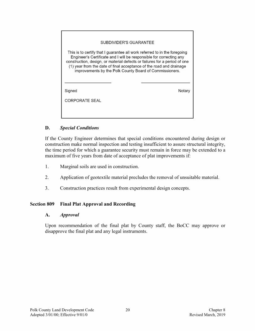
C. Subdivider's Guarantee
Prior to plat approval and at the time of final acceptance of improvements by the County, the subdivider shall provide the following subdivider’s guarantee:
Polk County Land Development Code 20 Chapter 8 Adopted 3/01/00; Effective 9/01/0 Revised March, 2019
D. Special Conditions
If the County Engineer determines that special conditions encountered during design or construction make normal inspection and testing insufficient to assure structural integrity, the time period for which a guarantee security must remain in force may be extended to a maximum of five years from date of acceptance of plat improvements if:
1. Marginal soils are used in construction.
2. Application of geotextile material precludes the removal of unsuitable material.
3. Construction practices result from experimental design concepts.
Final Plat Approval and Recording
A. Approval
Upon recommendation of the final plat by County staff, the BoCC may approve or disapprove the final plat and any legal instruments.

Polk County Land Development Code 21 Chapter 8 Adopted 3/01/00; Effective 9/01/0 Revised March, 2019
B. Cost
The actual cost of recording and preparing all required prints and reproductions shall be paid by the applicant.
Re-plats and Modifications
A. Vacating and Re-platting
Whenever land comprising all or part of an existing plat of record is proposed as all or part of a new plat, it shall be in accordance with the procedures as set forth in Chapter 177, F.S.
B. Revision of Final Plat After Board Approval
No changes, erasures, modifications or revisions shall be made on any final plat after approval has been given, unless the plat is resubmitted to the BoCC for its approval. This shall not affect the right to file an affidavit confirming an error on a recorded plat as provided by law. Any change, other than those listed in Section C, shall be considered a major modification or re-plat and shall be processed as a major subdivision pursuant to Section 803.C.
C. Minor Modifications
When it is necessary to change a plat which has been duly recorded, the applicant may proceed with submission of the final plat to the County. The minor subdivision process in Section 803.B. shall apply if one or more of the following modifications are proposed:
1. Lot lines are adjusted, provided that the number of lots does not increase and the individual lot sizes still meet the minimum lot size prescribed in this Code.
2. Minor adjustments in street alignments.
3. Release or dedication of easements.
4. Street name changes.
Streets (Rev. 06/08/04 Ord. 04-09)
Any development which includes or is required to construct, widen or improve a public or private street shall adhere to the design and construction requirements in this Section and Sections 821 through 824.
A. Clear Visibility Triangle
In order to provide a clear view of intersecting roads to the motorist, there shall be a triangular area of clear visibility formed by two intersecting roads or the intersection of a driveway and a road pursuant to Section 711.

Polk County Land Development Code 22 Chapter 8 Adopted 3/01/00; Effective 9/01/0 Revised March, 2019
B. Traffic Signs and Signalization
All required traffic signs and signalization shall be installed by the applicant prior to acceptance by the County. The County may, prior to acceptance of roads, accept from the applicant a deposit of sufficient funds to provide all required traffic signs and signalization.
C. Right of Way Requirement
All residential and non-residential development shall provide additional road right of way on all public roads adjacent to the development, if required. The roads rights-of-way requirements shall be in accordance with Table 8.2 and Table 8.3 in Chapter 8 of this Code.
D. Street Re-Designation (Rev. 06/08/04 Ord. 04-09)
1. An existing street proposed for designation as public or where public funds will be used for street maintenance shall met the requirements of Section 811- Streets; 821- Access; 823- Right of Way; 824- Roadway Design; 830- Uniform Street Address System; 707- Sidewalks; 740- Stormwater Management; and 760- Signs. Designation of a street as public shall require approval be the Board of County Commissioners.
2. Designation of an existing street as private shall require approval by the Board of County Commissioners. Maintenance and upkeep for the street and other common facilities, including drainage pipes, inlets, ponds, and street signs, shall be identified and provided for by a maintenance agreement, easement agreement, or other similar agreement as approved by the County Attorney. A street designated as private shall provide access for emergency or public service, e.g. Fire Safety, EMS, Sheriff, or utilities.
3. The applicant for re-designation of an existing street shall:
a. Provide a resolution from the homeowners association authorizing the request for street designation. When there is no homeowners association, the request must be signed by a majority of owners of lots with frontage on the affected street.
b. Provide a copy of letters of consent from utility companies providing service.
c. Provide all funds necessary to upgrade the street facilities including removal of obstructions within the road right of way, engineering, surveys, and legal fees.
d. Provide other information necessary to process the application.

Polk County Land Development Code 23 Chapter 8 Adopted 3/01/00; Effective 9/01/0 Revised March, 2019
819 Reserved
Subdivision Design Standards
A. Approval
No subdivision plat shall be approved under the provision of this Code unless the subdivision satisfies the standards and requirements set forth herein.
B. Lot Depth
In the UDA, UGA, and SDA a lot platted for residential purposes shall not exceed 500 feet in depth.
Access (Rev. 06/08/04 Ord. 03-94; 4/4/02 - Ord. 02-18; 2/11/02 - Ord. 02-07;)
A. Access Through Platted Residential Lots
1. Access through a platted subdivision to adjoining property shall not be permitted through existing lots which have been platted for residential purposes.
2. Access may be allowed through tracts which have been recorded as part of a plat for the expressed purpose of future road access.
3. All roads and road rights-of-way recorded as of 1992 for future road access shall be the minimum required for a road based on the potential functional classification of the road and the master development plan for the area.
4. Any deviance from Section 821.A shall require a Level 4 Review.

Polk County Land Development Code 24 Chapter 8 Adopted 3/01/00; Effective 9/01/0 Revised March, 2019
Table 8.1 Minimum Clear Recovery Zone
Type of Facility
Posted Speed
(MPH), 30 & Below
Posted Speed
(MPH), 35
Posted Speed
(MPH), 40
Posted Speed
(MPH), 45
Posted Speed
(MPH), 50
Posted Speed
(MPH), 55
Posted Speed
(MPH), 60 & Above
RURAL1 Local 6 feet
Local 6 feet
Collectors10 feet
Arterials & Collectors ADT<1500 14 feet
Arterials & Collectors ADT<1500 14 feet
Arterials & Collectors ADT<1500 18 feet
Arterials & Collectors ADT<1500 24 feet
RURAL Collectors10 feet
Collectors 10 feet
Arterials 14 feet
Arterials & Collectors ADT∃1500
18 feet
Arterials & Collectors ADT∃1500
18 feet
Arterials & Collectors ADT∃1500
24 feet
Arterials & Collectors ADT∃1500
30 feet
RURAL Arterials 14 feet
Arterials 14 feet
URBAN2 4 feet 4 feet 4 feet 4 feet N/A3 N/A3 N/A3
Table 8.2 Minimum Roads and Right of Way (R O W) Widths (Rev. 9/13/06 - Ord. 06-047; Rev. 06/08/04 Ord. 03-96)
Road Type and Number of Lanes
No Curb,
Pavement
No Curb, R-O-W
Depressed Curb (Village
Section), Pavement
s
Depressed Curb (Village
Section), R-O-W
Curb & Gutter (Urban
Section), Pavement
Curb & Gutter (Urban
Section), R-O-W
Local Roads, Two travel lanes 20 feet 60 feet 20 feet 40 feet4 20 feet 40 feet4
Two Lane Collector Roads 24 feet 80 feet 24 feet 60 feet 24 feet 60 feet
Future Capacity Road Needs (Four Lane Collector
or Arterial Roads) 48 feet 120 feet 48 feet 120 feet 48 feet 120 feet
1 Use Rural for Urban Facilities when no curb and gutter or a depressed (Miami) curb is used.
2 From face of curb.
3 Curb and gutter not to be used on Facilities with Design Speed > 45mph.
4 Utility easements must be provided outside of the right of way.

Polk County Land Development Code 25 Chapter 8 Adopted 3/01/00; Effective 9/01/0 Revised March, 2019
B. Access to the County Transportation System (Rev.7/10/18 – Ord. 18-047; 4/4/02 - Ord. 02-18; Rev. 7/25/01 - Ord. 01-57)
1. When a tract of land to be sub-divided accesses a County road, such road shall be a paved County maintained road.
a. Where a proposed development entrance has no frontage on an existing paved public road, a paved road meeting the requirements of this Code shall be constructed connecting the proposed development to an existing paved public road meeting County standards, except as provided for in Section 705.B of this code.
b. A proposed development consisting of more than 2000 AADT shall provide either a minimum of two points of access to public roads meeting County standards or a boulevard type entrance.
C. Residential Access on Arterial and Collector Roads (Rev. 7/10/18 – Ord. 18-047; 06/08/04 Ord. 03-94; Rev. 2/11/02 - Ord. 02-07)
No new development shall create any parcels for single-family or duplex residential uses accessing on an arterial, urban collector, or rural major collector roadway, unless the parcels conform to the requirements specified in Table 8.3.
D. Lot Access
Primary lot access shall be from the side where the frontage width is measured.
Road Frontage (Rev.07/10/18 – Ord. 18-047; 06/08/04 Ord. 03-94)
A. Minimum Road Frontage
All new lots, except as provided for in Section 705.B, shall have a minimum road frontage based upon the classification of the road as follows:

Polk County Land Development Code 26 Chapter 8 Adopted 3/01/00; Effective 9/01/0 Revised March, 2019
Table 8.3 Minimum Road Frontage Requirements
Road Type Width 5
Arterial Road 350 feet 6
Urban Collector 150 feet 6
Rural Major Collector 210 feet 6
Rural Minor Collector 150 feet 6
Local Road 7 50 feet
Local Commercial 7 50 feet
B. Local Road Minimum Standards (Rev. 7/10/18 - 18-047; 3/25/03 - Ord. 03-26; 4/4/02 - Ord. 02-18; 9/26/01 - Ord. 01-70; Rev. 06/08/04 Ord. 03-94)
Unless different standards are established by a Planned Development (PD), all new lots fronting on a local road shall have a minimum frontage of 50 feet. A lot with less than 50 feet but more than 25 feet of road frontage will be allowed provided the following conditions are met:
1. No more than two contiguous lots with less than 50 feet but more than 25 feet of road frontage may be located less than 300 feet from another lot with less than 50 feet of road frontage as measured along the road right-of-way.
2. The portion of any lot which is less than 50 feet in width abutting a street or road which is publicly maintained and which provides the actual access to the lot may not extend to a depth of more than 435 feet from the street.
3. Lots located on a cul-de-sac or on a roadway with a curve of at least 90-degree may measure the minimum frontage width at the building setback line.
4. In no circumstance shall any lot be less than 25 feet wide.
5 All driveways shall meet the driveway separation criteria as outlined in Section 705.
6 The required lot frontage may be reduced by 50 percent if access to the lot is shared through a recorded easement with other lots created as part of the same development.
7 Shall also comply with the Local Road minimum standards as outlined in this section.

Polk County Land Development Code 27 Chapter 8 Adopted 3/01/00; Effective 9/01/0 Revised March, 2019
5. Except as otherwise authorized by this Code, all side lot lines shall be straight and unbroken to the greatest extent practical.
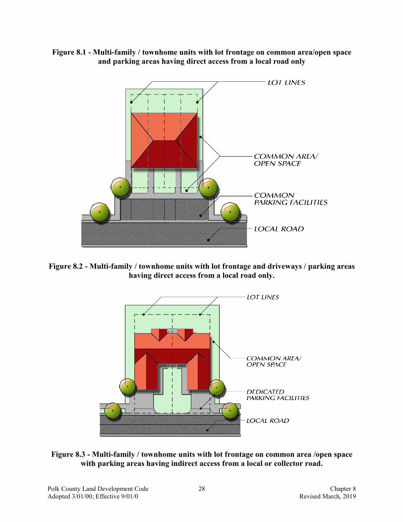
C. Multi-Family/Townhome Lot Access Standards (Added 03/19/08 - Ord. 08-004)
The following standards shall apply to the subdivision of lands for multi-family structures:
1. All newly created lots for multi-family/townhome developments shall not be required to have minimum road frontage as long as each unit has access to a paved road meeting County local road standards via a common area, open space, or common parking facility.
2. Parking areas or driveways for multi-family/townhome units shall either have direct access to a paved road meeting County standards or indirect access to a paved road meeting County standards via common area, open space or common parking facility.
3. Parking areas or driveways shall be designed to prevent vehicles from encroaching into, or obstructing, the public right of way.
4. All paring areas shall meet the criteria contained in Chapter 7 of this code.
5. Figures 8.1 through 8.4 illustrate potential parking and access scenarios for multi-family/townhome units.
Polk County Land Development Code 28 Chapter 8 Adopted 3/01/00; Effective 9/01/0 Revised March, 2019
Figure 8.1 - Multi-family / townhome units with lot frontage on common area/open space and parking areas having direct access from a local road only
Figure 8.2 - Multi-family / townhome units with lot frontage and driveways / parking areas having direct access from a local road only.
Figure 8.3 - Multi-family / townhome units with lot frontage on common area /open space with parking areas having indirect access from a local or collector road.

Polk County Land Development Code 29 Chapter 8 Adopted 3/01/00; Effective 9/01/0 Revised March, 2019
Figure 8.4 - Multi-family / townhome units with lot frontage on driveways / parking areas having direct access from a local road only.

Polk County Land Development Code 30 Chapter 8 Adopted 3/01/00; Effective 9/01/0 Revised March, 2019
Right-of-Way Requirements
A. Width
Right-of-way requirements for road construction shall be as specified in Table 8.3 of this Section.
B. Existing
In the development of an existing unimproved platted subdivision, or a new subdivision adjacent to an existing County road where right-of-way is deficient, additional right-of-way shall be provided from the centerline of the existing County road of sufficient width to meet the requirements of this Section (one half of the entire right-of-way requirement).
C. Boundary Roads
No half roads or road rights-of-way shall be accepted by the County along the boundary of a development unless the road or road right-of-way is required for a future road right-of-way in the Comprehensive Plan.
D. Protection and Use
1. No encroachment shall be permitted into existing rights-of-way.
2. Use of the right-of-way for public or private utilities, including, but not limited to sanitary sewer, potable water, telephone wires, cable television wires, gas lines or electric power transmission (this is not an inclusive list), shall be allowed subject to the placement specifications in Appendix A, Technical Standards Manual, and other applicable County regulations.
E. Vacating
The vacating of County maintained or platted rights-of-way and easements shall be in accordance with the following:
1. For the vacation of easements where no land boundary changes will result from the vacation, a certified description sketch performed in accordance with Chapter 61G17-6 of the F.A.C., pursuant to Chapter 472.027, F.S., shall be prepared and submitted. Where the easement is shown on a recorded plat, a certified copy of the plat shall be submitted with the easement area clearly marked.
2. For vacation of road rights-of-way and alleys where land boundary changes will result, a certified description sketch, performed in accordance with Chapter 61G17-6 of the F.A.C., pursuant to Chapter 472.027, F.S., shall be prepared and submitted.
a. A petition requesting the vacation shall be submitted to the Transportation Department Director. In addition to the required sketch, the petition should contain:

Polk County Land Development Code 31 Chapter 8 Adopted 3/01/00; Effective 9/01/0 Revised March, 2019
i. signatures of all adjoining property owners.
ii. letters of consent to the vacation by all property owners gaining access by the requested vacation.
iii. letters of consent to the vacation from the local utility companies (electric, water, telephone, cable, and gas).
b. Petitions to vacate rights-of-way shall be considered upon a finding that all of the following requirements are met:
i. The requested vacation is consistent with the Traffic Circulation Element of the Comprehensive Plan.
ii. The vacation would not jeopardize the current or future location of any utility.
iii. Any necessary utility easements have been provided in the area to be vacated.
iv. The proposed vacation is not detrimental to the public interest.
v. The right-of-way does not provide the sole access to any property.
Roadway Design (Rev. 06/08/04 Ord. 03-96; Rev. 06/08/04 Ord. 03-94)
A. Applicability
This Section establishes minimum requirements for transportation system components including public and private roads, and sidewalks. The standards in this Section are intended to assure that all developments adequately and safely provide for movement of vehicles consistent with sound engineering and development design practices.
B. General Provisions (Rev. 06/08/04 Ord. 03-96)
1. All elements of the transportation system shall be provided and designed in compliance with the engineering design and construction standards contained in Appendix A, Technical Standards Manual.
2. All roads in the County are classified according to the function served in order to allow for regulation of access, road and right-of-way widths, circulation patterns, design speed, and construction standards.
3. The County Road Inventory and any amendments thereto, adopted by the BoCC, is hereby made a part of this Code. The inventory shall be the basis for all decisions which are based on functional classification including, but not limited to, required road improvements, reservation or dedication of rights-of-way for required road improvements, or access of proposed uses to existing or proposed roadways.

Polk County Land Development Code 32 Chapter 8 Adopted 3/01/00; Effective 9/01/0 Revised March, 2019
4. All new roads (public and private) shall be designed and constructed in accordance with this Section and Appendix A, Technical Standards Manual. Existing private roads proposed for designation as public and involving construction, reconstruction, facilities upgrade or right-of-way dedication shall meet the provisions of this chapter and Appendix A.
5. Table 8.3 specifies the minimum pavement and right-of-way widths for local roads. All Collector roads and Arterial roads shall be designed in accordance with the FDOT Manual for Uniform Minimum Standards for Design, Construction, and Maintenance for Streets and Highways (the AGreen Book@).
6. Utilities may be located in easements or right-of-way and shall be designed in accordance with Appendix A, Technical Standards Manual.
7. The minimum distance from the edge of the pavement which shall be free of obstruction as required by Table 8.2.
8. All sidewalks, bikeways and stormwater facilities shall be designed and constructed in accordance with the provisions of Appendix A, Technical Standards Manual.
C. Roadway Development Standards (Rev. 12/08/03 Ord. 03-69; Rev. 06/08/04 Ord. 03-94)
1. All new roads (public and private) shall be designed and constructed in accordance with this Chapter and Appendix A, Technical Standards Manual. For any standards not specifically addressed in Appendix A, the FDOT standards may be used as approved by the County Engineer.
2. The road layout in all new development shall be coordinated with and interconnected to the road system of the surrounding area where specifically required in the Comprehensive Plan.
3. Public roads and sidewalks in developments may be connected to rights-of-way in adjacent areas to allow for proper inter-neighborhood traffic flow. If adjacent lands are un-platted, interconnecting public roads in the new development may be provided for future connection to the adjacent un-platted land. These interconnecting public access points shall not be used as the primary access to adjacent un-platted properties unless the public road is constructed in accordance with Section 821.
4. Local roads should be arranged to discourage through traffic.
5. Roads shall intersect at right angles.
6. New intersections along one side of an existing road shall coincide with the center lines of existing intersections. Where an offset is necessary at an intersection, the distance between center lines of the intersecting roads shall be no less than 150 feet except when divided by a raised median.
Polk County Land Development Code 33 Chapter 8 Adopted 3/01/00; Effective 9/01/0 Revised March, 2019
7. No two roads may intersect with a local road on the same side at a distance of less than 150 feet measured from centerline to centerline of the intersecting road. When the intersected road is an urban collector or rural major collector, the distance between intersecting roads shall be no less than 440 feet.
8. Access to subdivisions by fire apparatus shall not be less than 20 feet (6 meters) of unobstructed width, able to withstand live loads of fire apparatus, and shall have a minimum vertical clearance of 13 feet, six inches.
D. Roads with No or Limited Outlet (Rev. 12-08-03 Ord. 03-69)
1. A turnaround shall be located at the terminus of any road greater than 150 feet in length with no outlet.
2. Cul-de-sac turnarounds shall consist of a travel lane with a minimum outside turning radius of 50 feet.
3. Turnarounds shall be designed and constructed pursuant to Appendix A, Technical Standards Manual.
4. Subdivision roads that cross railroad tracks or bridges shall provide a second outlet.
E. Temporary Interconnecting Roads
1. Temporary local interconnecting roads may be permitted only within subsections of a phased development for which the proposed road in its entirety has received Final Site Plan approval. However, interconnecting roads may be permitted or required by the County provided that the future extension of the road is deemed desirable by the County or conforms to an adopted County Transportation Plan and is included in a Master Site Plan.
2. Temporary turnarounds shall be provided for all interconnecting roads providing access to five or more lots or housing units or more than 200 feet in length.
3. Temporary interconnecting roads shall be designed and constructed pursuant to the standards in Appendix, Technical Standards Manual.
F. Roadway Construction Standards
1. The applicant or contractor retained by the applicant to construct the development shall give the County at least five days written notice before the commencement of any construction.
2. A pre-construction meeting is required prior to the commencement of construction.
3. Clearing and grubbing shall be accomplished on the entire width of rights-of-way dedicated by the plat as public roads. This clear area shall include all area between the edge of pavement and the edge of right-of-way. No trees shall remain within the Minimum Clear Recovery Zone.

Polk County Land Development Code 34 Chapter 8 Adopted 3/01/00; Effective 9/01/0 Revised March, 2019
4. All roadway improvements resulting in a change in the travel lane on existing roads shall include an overlay of the existing pavement between the limits of the improvement.
5. All rights-of-way other than pavement, shall be either grass sodded, or seeded and mulched on swale section roadways in accordance with FDOT Standard Specifications, except that only Bahia, Bermuda and Centipede or St. Augustine grasses will be permitted unless specifically approved by the County Engineer. All roadways shall incorporate a two foot grass sod strip behind the curb or edge of pavement.
6. All roads associated with new development shall be paved.
7. All roads associated with new development shall be striped in accordance with County standards.
8. Curbing shall be required in accordance with the following standards:
a. Curbing shall be required for the purposes of drainage, safety, and delineation and protection of pavement edge along roads in the following cases:
i. Along designated parking lanes.
ii. Where the surface drainage plan requires curbing to channel storm water.
9. Curbing shall be required for all residential development with a net density of three or more units/acres located in the Urban Development Area (UDA), the Urban Growth Area (UGA), and the Suburban Development Area (SDA).
10. All curbing shall conform to the construction standards contained in Appendix A, Technical Standards Manual.
11. Shoulders are required on all local roads and collector roads and shall conform with the typical section contained in Appendix A, Technical Standards Manual. Shoulders shall be provided on each side of roads and located within the right-of-way as indicated in Table 8.3.
12. Acceleration, deceleration, and turning lanes shall be designed and constructed in accordance with Section 705 and Appendix A, Technical Standards Manual.
13. Medians shall be constructed as follows:
a. All roads, divided by a median, shall have a minimum pavement width on both sides of the median meeting the minimum established in Table 8.3. Multiple travel lanes shall be striped.
Polk County Land Development Code 35 Chapter 8 Adopted 3/01/00; Effective 9/01/0 Revised March, 2019
b. Medians at intersections shall not extend beyond the backside of the radius return to insure safe turning movements.
c. Design of roadways and medians shall provide for safe movement of anticipated traffic.
d. Where boulevard entrances are provided to residential and non-residential developments vehicle lane striping and marking shall be provided to reflect the number of lanes provided and approved turning movements from each lane.
e. Guard houses or entrance gates may be located on private residential streets provided their location does not present a traffic hazard, obstruct the visibility triangle, impeded drainage or adversely interfere with the use of the right-of-way by approved utilities.
f. Landscape medians may be located on private residential streets and may contain trees and other landscaping material provided their location does not present a traffic hazard, obstruct the visibility triangle, impede drainage or adversely interfere with the use of the right-of-way by approved utilities. Maintenance of landscape islands shall be the responsibility of a homeowners association.
829 Reserved
Section 830 Uniform Street Address System
A. Applicability
This Code shall apply to the unincorporated areas of Polk County unless an inter local agreement is entered into between the Board of County Commissioners and a municipality or postal service assigning addressing authority over a designated territory to the Enhanced 911 Office.
B. Enclaves
1. Any territorial unit within the unincorporated area of Polk County may be designated as an Enclave at the discretion of the County Manager provided the governing authority of such territorial unit has established a roadway naming and address numbering system which is consistent with the Uniform Street Address System established by Ordinance 90-38 and this Code.
2. The governing authority of an Enclave shall have and retain authority to assign roadway names, and building numbers within such Enclave, subject to the approval of the Enhanced 911 Office.

Polk County Land Development Code 36 Chapter 8 Adopted 3/01/00; Effective 9/01/0 Revised March, 2019
C. Enhanced 911 Office
1. The Enhanced 911 Office of the Polk County Department of Public Safety Emergency Management Division shall design, implement, administer, operate and maintain the Enhanced 911 Emergency Telephone System and the Uniform Street Address System.
2. The Enhanced 911 Office shall:
a. Gather information concerning all roadway names assigned before the effective date of this Code and Ordinance 90-38 and other information from Polk County and the Enclaves to determine whether such roadway names comply with Section 336.05, F.S., this Code, and Ordinance 90-38.
b. Design and prepare a Street Naming System, Structure Numbering Plan, Address Numbering Maps and the Uniform Street Address System established by Ordinance 90-38 in accordance with requirements set forth in this Code and with the assistance of other departments and divisions of Polk County as directed by the County Manager.
c. Review, in cooperation with any pertinent Enclave, proposed roadway names and designations in proposed plats for subdivisions in the unincorporated areas of Polk County to determine whether such proposed roadway names and designations comply with Section 336.05, F.S., this Code, and Ordinance 90-38.
d. Assign building numbers to each existing building and for each subsequently constructed building in accordance with the Structure Numbering Plan described in Section F and subject to the approval of the Enhanced 911 Office.
D. Establishment of Uniform Street Address System
Polk County shall establish and govern a Uniform Street Address System devised by the Enhanced 911 Office or a designated Enclave by adopting a grid system which is a system of vertical and horizontal axis and which shall incorporate the Uniform Street Naming System and Uniform Structure Numbering Plan in compliance with this Code. The Uniform Street Address System shall be implemented in accordance with the following procedures:
1. If a building is located on a lot which is adjacent to two or more roadways, the roadway name to be used in that building’s address shall be the name of the roadway by which the building is accessed and the number to be assigned to such building shall then be determined in accordance with this Code and Section 7 of Ordinance 90-38.
2. If a roadway runs in both north to south and east to west directions, the direction of such roadway, for the purpose of assigning even or odd numbers to buildings on a

Polk County Land Development Code 37 Chapter 8 Adopted 3/01/00; Effective 9/01/0 Revised March, 2019
given side of the roadway, shall be determined by the direction in which the greater proportion of the roadway runs or by such other logical means as would minimize confusion where a predominant direction cannot be reasonably determined.
3. The Enhanced 911 or a designated Enclave may retain the address numbering schemes used for mobile homes, lots within mobile home parks, or units within multiple building complexes as authorized or assigned prior to the effective date of this Code and Ordinance 90-38 by the United States Postal Service, the government of Polk County, or the government of an Enclave, if retention of such address number schemes is more reasonable.
4. In situations where it would be more reasonable or practical for the Enhanced 911 Office to assign a roadway address to a building located in close proximity to an Enclave based on a separate grid numbering system used by such Enclave, it shall be within the discretion of the Enhanced 911 Office to assign a number to such building in conformity with such separate grid numbering system.
5. Within 30 days after a parcel of land, a subdivision, or and part thereof, becomes part of the unincorporated area of Polk County by municipal contraction or otherwise, the Enhanced 911 Office or applicable designated Enclave shall review the address numbers of such property and determine whether such numbers, their posting, and the method of numbering for such contracted portion conform to the designated system and the Structure Numbering Plan established by Ordinance 90-38 and this Code.
E. Establishment of Street Naming System
Polk County shall establish and govern a Street Naming System in accordance with the following procedures:
1. All roadways named by the recording of plats containing such names or by the assignment of such names by other authorized means prior to the effective date of this Code and Ordinance 90-38, including roadways within mobile home and RV parks and multiple building complexes, may retain their names. Additionally, such previously assigned roadway names shall be included on the Address Numbering Maps by the Enhanced 911 Office unless the Enhanced 911 Office determines that renaming of such roadways is necessary to avoid duplication, inconsistency or confusion in the provision of emergency services. In such cases where renaming roadways is necessary, the roadways shall be renamed in accordance with Section 336.05, F.S., this Code, and Ordinance 90-38.
2. Each unnamed roadway in existence on the effective date of Ordinance 90-38 and this Code. Each roadway which comes into existence thereafter shall be named in accordance with Section 336.05, F.S., this Code, and Ordinance 90-38, subject to the approval of the Enhanced 911 Office, regardless of whether such roadway is located within a platted subdivision, mobile home or RV park, or multiple building complex.
Polk County Land Development Code 38 Chapter 8 Adopted 3/01/00; Effective 9/01/0 Revised March, 2019
3. As names are assigned to existing unnamed roadways and assigned to new roadways through the platting of subdivisions or other authorized means, such roadway names and new roadways shall be included on the Address Numbering Maps.
F. Establishment of Structure Numbering Plan
Polk County shall establish and govern a Structure Numbering Plan in accordance with the following procedures:
1. All buildings for which building permits or mobile home set-up permits were issued before the effective date of this Code and to which building numbers were assigned by a public utility, the United States Postal Service, the government of Polk County, or the government of an Enclave, and to which such number were assigned in compliance or conformity with the grid numbering system described in this Code, and other requirements of this Code and Ordinance 90-38, shall retain such numbers.
2. All buildings for which building permits or mobile home set-up permits are issued on or after the effective date of this Code and Ordinance 90-38 shall be numbered in compliance with the requirements of this Code.
3. Mobile homes and mobile home lots located within a mobile home park and units located within a multiple building complex shall be numbered in accordance with the city style Addressing System.
G. Posting of Building Number
It shall be the joint duty and responsibility of the owners and occupants of each building located in the unincorporated areas of Polk County to post or display the assigned building number on or near such building in accordance with the following requirements:
1. The building number shall be displayed by the permanent attachment or affixing of the building number to the building front or to a separate structure located in front of the building, such as a mailbox, post, wall or fence.
2. The building number shall be clearly visible and legible from the roadway on which the building faces and shall clearly identify the building to which it is assigned.
3. The building number shall be displayed by the use of Arabic numerals of a height not less than three inches and of a color which contrasts with the color of its immediate background.
4. The numerals used for the display of a building number shall be made of a durable weather resistant material and shall be permanently affixed to their supporting structure.
Polk County Land Development Code 39 Chapter 8 Adopted 3/01/00; Effective 9/01/0 Revised March, 2019
5. The owners and occupants of buildings in the unincorporated areas of Polk County which are in existence on the effective date of this Code are required to comply with this Section within 90 days from the effective date of this Code.
6. The owners and occupants of each building erected on or after the effective date of this Code shall comply with this Section as a prerequisite to obtaining a Certificate of Occupancy.
H. Lot Numbering and Posting for Mobile Home and RV Parks
Notwithstanding any other provision of this Code to the contrary, all new Mobile Home and RV Parks shall be addressed according to established city style addressing schemes.
1. Roadway name signs shall be erected internally within Mobile Home and RV Parks and the cost of such roadway markers shall be the responsibility of the Mobile Home or RV Park owner.
2. Address numbers shall be posted on mobile homes or RVs and placed where they can be easily seen from the roadway on which they face. The cost of the address numbers shall be the responsibility of the mobile home or RV owner.
3. City style addresses shall be assigned to the lots within Mobile Home and RV Parks in accordance with the provisions of the other Sections of this Code and Ordinance 90-38.
4. Lots within existing Mobile Home and RV Parks may be re-addressed, on a case by case basis, in compliance with the requirements of this Code and Ordinance 90-38.
I. Violations and Penalties
1. The Codes Enforcement Division shall have the authority and duty to investigate reported violations of this Code and Ordinance 90-38 and to proceed against violators of Ordinance 90-38 as specified in Polk County Ordinance 85-06, as amended.
2. The owner and occupant of any building in the unincorporated areas of Polk County which is not in compliance with the provisions of this Code and Ordinance 90-38 shall be subject to prosecution before the Polk County Code Enforcement Board and shall be subject to administrative fines and liens as set forth in Polk County Ordinance No. 85-6, as amended.

Polk County Land Development Code 40 Chapter 8 Adopted 3/01/00; Effective 9/01/0 Revised March, 2019
J. Adoption of a Procedures Manual
The Enhanced 911 office shall prepare a procedures manual to be used for establishing addressing guidelines. The manual shall be detailed, explaining procedures for public notification of address changes, the procedures for County staff and County citizens to follow to petition for roadway name designations and changes, and what the criteria are for naming a roadway.


