36
Chapter 9 Land Transportation in the White Lake Area The old Montague-Whitehall freight station. (White Lake Area Chamber of Commerce)

Chapter 9 Land Transportation 1
Chapter 9Land Transportation
in the White Lake Area
The old Montague-Whitehall freight station. (White Lake Area Chamber of Commerce)

The Railroad DepotBy Willis F. Dunbar
On any given railroad [the stations] were very much alike, being built according to uni-form plans of the company’s engineering staff. Usually they were wooden frame structures. There was a central waiting room, with wooden seats clustered around a big potbellied stove. Adjacent was the ticket office with its clicking telegraph instrument. It usually had a bay window, making it possible for the agent to look up and down the main track. Attached to the building was storage space for express and way-freight, with an elevated platform to facili-tate loading and unloading. Baggage carts, drawn by hand, were pulled alongside the train to unload mail and express as well as baggage. Numerous sidetracks branched off the main line in the vicinity of the station, and located nearby were usually a grain elevator, a coal shed, a lumber yard, and almost always a hotel.
The small-town railroad station, invariably called the “depot” (and always pronounced deepo, not depo, in the French manner), was a community institution, a gathering place for young and old, whether or not they were travel-bent. There was nothing in a small town to rival the excitement aroused when the whistle of a passenger train was heard faintly in the distance and you rushed out of the depot to see her come around the curve. A youngster would often put his ear to the rail, thinking he could hear the rumble of the oncoming train better. The train whistled for each road crossing (a short and a long, a short and a long) and then when approaching the station, there was one long whistle, blown presumably to an-nounce the train’s coming. With steam escaping here and there, the giant iron horse majesti-cally approached, finally coming to a halt as conductor and brakeman swung from the steps and placed down the boxes on which passengers could step in alighting from or boarding the coaches. It was all hurry and bustle until the conductor yelled “All Aboard,” and signaled the engineer. The latter started the blower, and with an increasing tempo of determined puffs the locomotive pulled the train down the line to the next town. After the train was well under way, the sound of the blower was no longer heard.
Willis F. Dunbar, All Aboard: A History of Railroads in Michigan, Grand Rapids, William B. Eerdmans
Publishing Company, 1969, 209-210

Chapter 9Land Transportation
in the White Lake Area
The Whitehall depot, circa. 1900, stood on the east side of Lake Street at the foot of Sophia Street. This view is looking southward. (Yakes collection)
Railroads, trains, highways, automobiles, and truckshave been sources of inspiration for countless lyr-
icists, poets, novelists, and other writers. Sometimes the words memorialize a particular railroad, such as the Rock Island Line or the City of New Orleans, or a famous highway, such as Route 66. Sometimes they wax nostalgic about the “clickety clack of the train on the track,” (It’s a Beautiful Sound), On other occasions the story is about the freedom and joy of travel by rail or highway as in King of the Road and On the Road Again.
In his famous poem, The Road Not Taken , Robert Frost used a lightly travelled forest lane as a metaphor representing the choices we must all make as we pass through life.
Two roads diverged in a yellow wood,And sorry I could not travel bothAnd be one traveler, long I stoodAnd looked down one as far as I couldTo where it bent in the undergrowth;
Then took the other, as just as fair,And having perhaps the better claim,Because it was grassy and wanted wear;Though as for that the passing thereHad worn them really about the same,
And both that morning equally layIn leaves no step had trodden black.Oh, I kept the first for another day!Yet knowing how way leads on to way,I doubted if I should ever come back.
I shall be telling this with a sighSomewhere ages and ages hence:Two roads diverged in a wood, and I-I took the one less traveled by,And that has made all the difference. Two roads diverged in a yellow wood.
4 White Lake History
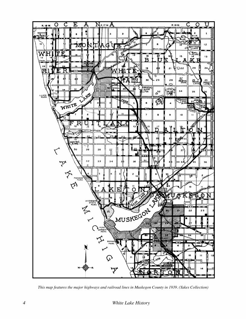
This map features the major highways and railroad lines in Muskegon County in 1939. (Yakes Collection)

Chapter 9 Land Transportation 5
Bruce Catton used that same theme in his nostalgic description of his early life in Benzonia, Michigan. In Waiting for the Morning Train, Catton described the choices he had made in his life as analogous to the choices one had to make in order to travel via railroad from one side of the state to the other. Long distance travel entailed making numerous transfers from one rail line to another, while hopscotching from depot to depot, trying to achieve maximum efficiency of time, expense, and possibly pleasure.
Travel by land was arduous and time-consuming in the late nineteenth and early twentieth centuries. The earliest foot-travelers to and from White Lake, trod the Lake Michigan beach or tramped trails through the forest and underbrush, following the paths of least resistance. Gradually those trails gave way to two-tracks and tote roads, some of which evolved into roads and railroads.
When it came to conveying large quantities of freight and passengers over broken terrain and considerable dis-tances, nothing could beat a railroad. They were expen-sive to build and to maintain, of course, but they were essential to the settlement and development of the inte-rior. Paved roads helped fill in the gaps where railroads could not be easily built, but they were secondary to the rail lines during the late nineteenth and early twentieth centuries.
Railroad stations were also vital to town develop-ment. In small towns, like Montague and Whitehall, the railroad depot was the social and commercial center of the community. Kids flocked to the depot just to see what was going on when school was not in session. Old-er folks went there to greet passengers or see them off, deliver or receive freight shipments, and pick up gossip
from the station agent and the train crews. Most small towns had other social centers, of course, such as the post office, the drug-stores, the general stores, the sa-loons, and the barber and beauty shops, but the depot was the number one spot for that sort of interaction.
The station agent was an important man in the com-munity. He had to be highly intelligent and versatile in order to do his job properly. He was a combination tele-graph operator, route calculator, accountant, cashier, and handyman. He sold tickets (usually in bunches for those passengers who had to make numerous transfers from one rail line to another), checked baggage, determined passenger and freight rates, loaded and unloaded freight, and assuaged angry passengers when things did not go well. He had to be able to calculate the easiest, short-est, and cheapest way to get from one point to another by rail. He had to keep track of varying rates, a hodge-podge of state and federal laws, and a host of arcane railroad rules.
Automobilists in the early twentieth century faced adventure at all times on the dirt roads of that era. (Yakes Collection)
The Pere Marquette railroad depots in Holland (top) and Hart (bottom) depict the range of architectural styles found
along the west coast of Michigan. (Yakes Collection)

6 White Lake History
He normally worked a minimum of twelve hours a day, six days a week, but was on call the rest of the time as well. Customers felt the same. If a farmer or local businessman wanted to get his freight at midnight, he expected the agent to be ready for him.
Earl Pillman served as the agent in charge of the Montague depot from 1912 to 1926, when six passen-ger trains and four freight trains ran through Montague and Whitehall every day. He recalled that on an average twelve-hour winter day, one of his biggest chores was to keep the stoves going. “I had to be on duty at 7 a.m. and had three such stoves to build fires, one for each of the two waiting rooms and one for the office. If we had zero weather I would freeze until about 11 a.m. and the waiting passengers never did get sufficient heat.”
To make matters worse, he had to put up with local pranksters who nailed the coal buckets to the floor on bitterly cold nights, while he was outside managing the arrival of the late train.
The Pere Marquette Railroad
The Pere Marquette Railroad (PMRR) was, at one time, the largest railroad system in the state of Michi-gan and the only railroad servicing the White Lake area. It provided north/south service along the lakeshore.
South-bound trains provided connections to Muskeg-on and other points, all the way to the state line and beyond. Rail connections at Muskegon gave access to innumerable destinations to the east and west (via car ferries) throughout the country. Pere Marquette’s route. north of Montague, extended only as far as the village of Mears in Oceana County (a tiny burg just beyond the larger village of Pentwater). The locals were always hoping the road would eventually be extended further north to Ludington or Manistee, but their hopes were in vain. Both Ludington and Manistee had access to car ferries that traversed Lake Michigan at that time.
Douglas Malloch, a writer for the Chicago-based American Lumberman, travelled extensively through-out Wisconsin and Michigan during the late nineteenth and early twentieth centuries. He was on a nodding ac-quaintance with most of the depots in western Michigan at that time. While spending a few hours in the Pere Marquette depot in Hart in 1920, he pondered what might happen if the railroad connected with the larger towns further north.
We don’t know anything about running a rail-road – in which we have nothing on the Gov-ernment - but the historical mystery of western Michigan is why the Pere Marquette never built an extension of the old Chicago & West Mich-igan Railway from Pentwater to connect with its northern lines at Ludington and Manistee. There is talk of it again, when extensions be-come an economic possibility.
Will Olson drove us from Manistee to Hart this morning, never at a speed exceeding six-ty-five miles an hour, and you wouldn’t know this old lumber country now. For now it is a region of beautiful valleys, fine farms, good roads, and superabundant crops. When the lake shore – from Chicago to Petosky via Michigan City, St. Joseph and Benton Harbor, Holland, Grand Haven Muskegon, Whitehall, and Mon-tague, Hart, Pentwater, Ludington, Manistee and Traverse City – becomes the main line of the Pere Marquette, as it sometime will, then there will be an even greater development of the favored region, which has a better climate than Italy and lots more of it.
White Lakers had a love-hate relationship with the Pere Marquette Railroad. It was one of the lifelines of the community, but there were strings attached. They
(A portion of the Pere Marquette Railroad Timetable from 1914 shows the passenger station stops along the stretch from Allegan to Hart. (Yakes Collection)

Chapter 9 Land Transportation 7
needed the railroad to make the economy function properly, especially during the winter months when al-ternative forms of commerce were unavailable. Howev-er, customers were obliged to accept the railroad’s high freight and passenger rates and had to cope with poor and inadequate service on many occasions.
The railroad was vital to the tourist trade. Prior to the development of the West Michigan Pike, in the 1910s, resorters depended on the railroads to transport them from Chicago and other cities in the upper Mid-west to their summer resort lodgings on White Lake.
Local businessmen and industrialists also depended on the railroad to satisfy their shipping needs. Commer-cial fishermen and area farmers shipped at least some of their harvest by rail, especially after the Goodrich Line ceased operations to the White Lake area in 1931. Law-yers and businessmen who had business in Muskegon (the county seat), often commuted by train. Doctors visited their patients in the two Muskegon hospitals by taking the train. The morning train usually brought the morning newspapers and products people had ordered from the Sears, Roebuck and Montgomery Ward cata-logues. Most of the bread sold in area grocery stores and served at area restaurants, also arrived on the morning train, having been baked in one of the Muskegon bak-eries. The afternoon and evening trains usually carried passengers destined for local hotels and cottages. Mer-chants, saloon keepers, farmers and others depended on the railroad to transport merchandise, supplies, and the equipment they needed to run their businesses.
The arrival of any train caused a stir of excitement in both Montague and Whitehall, especially during the spring, summer and early fall, when the local depots buzzed with activity. According to Helen Panzl, a re-porter for the local newspaper, “Many people enjoyed walking to the depot on a balmy day just to see who got on or off the train, and to chat a while with others they might encounter there.”
The Pere Marquette Railway System encompassed much of the lower peninsula of Michigan as well as portions of Ontario, Indiana, Illinois, and Wisconsin. (Yakes Collection)
The Whitehall passenger and freight deport was, at one time, the center of the town’s commercial activity. (Pillinger Collection)

8 White Lake History
During the summer months, draymen from both towns met every train. Draymen hauled freight to des-tinations far and near. They also delivered passengers to the Franklin House, the White Lake Villa, the Mears Hotel, the White Lake Villa, Rochdale resort, and other hotels in the area. During the harsh days of winter, busi-ness was much less hectic.
Montague and Whitehall each had its own passen-ger and freight station, located only about a mile apart. The Montague station stood at the foot of Spring Street, while the Whitehall Station was on Lake Street near the foot of Sophia Street.
The nation’s railroads were vital to the local econo-mies in towns and cities throughout the country.
Every pound of goods for local merchants and farm-ers, from bread to tractor engines, came by rail. Every-thing the farmers raised from hay to dairy products went out by rail. The U. S. mail went by rail and travelers [either] rode rail transportation or stayed at home. This made the railroad station the busiest place in town.
Montague and Whitehall were not quite as depen-dent upon the railroad as most other towns, as long as the Goodrich steamships provided an alternative form of transportation, but the steamships served White Lake only during the summer months and ceased local opera-tions, entirely, in 1931.
John Chisholm remembered that the passenger trains were usually crowded, back in his day, especially during the summer months. “On Saturday nights from Muskeg-on there would be standing room only in the aisles, and not much of that. Occasionally another coach would be
hooked on at the North Yards [in Muskegon]. The load thinned out at Whitehall. . . .”
The saloons in Montague and Whitehall did a brisk business shipping cases of liquor on the north-bound trains. Oceana County was “Dry” for many years during the early twentieth century. Montague was the train’s last
The equipment assigned to the west Michigan branch of the railroad was not always the best. (Yakes Collection)
The Pere Marquette RR station in Montague stood at the foot of Spring Street. (Montague Museum)

Chapter 9 Land Transportation 9
stop prior to reaching the Oceana County line. Thirsty passengers from Oceana County sometimes took the train to Montague for the sole purpose of restocking their supplies of whiskey, beer and wine.
The PMRR was not always dependable, however, especially when winter snow storms blocked the tracks for days on end and spring floods washed away bridges and portions of the right-of-way. The Pere Marquette flirted with bankruptcy throughout most of its existence,
so the railroad did not have the cash reserves neces-sary to properly maintain its rails, bridges, tunnels and equipment. News of railroad calamities arrived far too frequently. The branch line serving western Michigan was not very profitable for the company, so managers tended to assign older equipment to the district and not
maintain the tracks as well as they did more profitable portions of their territory.
John Chisholm recalled spending one cold, snowy winter evening at the Montague depot with his moth-er, waiting to board the 9:20 p.m. train for Muskegon. They finally got into Muskegon about 3:00 a.m. the next morning.
The Montague to Pentwater stretch of the Pere Mar-quette Railroad was among the worst in the state and the stretch in Ottawa County was not much better. The company was in receivership in the early 1910s and was being investigated by a commission headed by Lieutenant Governor, John Q. Ross. In commenting on the railroad’s plight, Mr. Ross revealed that “the road is burdened with a host of branches which cost more to operate than they could possibly earn, but as these branches serve a distinct community in each case the state compels their operation.”
The Pere Marquette tunnel under Colby Street in Whitehall was a major bottleneck. The timbers and braces that help up the roof were old, worm-ridden, and rotten, sometimes falling loose. Conductors often stopped the train before entering the tunnel to make cer-tain it was safe. The railroad merely replaced the rotten wood, but did nothing to replace the tunnel.
The tunnel was also subject to rainstorms. A vio-lent storm in 1907 eroded both sides of Colby street as it passed over the tunnel, undermining the road sur-face and threatening the tunnel. Another storm in 1910 caused a washout at the tunnel that filled tunnel with tons of sand and gravel. Repairs tied up traffic for many hours.
Railroad accidents were commonplace. Early in Oc-tober of 1911, the north-bound Pere Marquette train de-railed one and a half miles from Mears due to spreading rails. The accident injured several passengers. In 1912 a Pere Marquette passenger train derailed because of a washout at Happy Creek, between Shelby and New Era. That same week a sand heap delayed another train north of Montague. In yet another illustration, in November of 1913, the southbound Pere Marquette, which passed through Montague and Whitehall every afternoon, de-railed south of Holland. According to a report in the local newspaper, “the entire train, with the exception of the engine, went into the ditch, taking fire almost as soon as the wreck occurred.” It was a short train, con-taining a combination mail/baggage car, a smoker, and
The Pere Marquette RR abandoned the Whitehall passenger depot, shown here, as well as the Montague depot, in 1926. (Yakes Collection)
After the Pere Marquette RR abandoned passenger service to the White Lake area in 1926, they built a freight station in Whitehall to replace the passenger stations that had previ-ously served the two towns. (Yakes Collection)

10 White Lake History
a day coach. Spreading rails caused the engine to tear up 500 feet of track before falling on its side. The day car, in which the passengers were riding, tipped over three times as it fell into a deep ravine, injuring all twenty-two passengers aboard. The cars all caught fire. According to the report, the “coaches were of an old style and oil lamps were used for lighting purposes. When the car turned over they were filled with oil from the broken
lamps, and soon the wreckage was a mass of flames.” The fire destroyed all of the baggage and mail aboard. In both instances, the problem was that the company had failed to replace its lightweight rails, when it upgraded to heavier locomotives and cars.
The Pere Marquette sometimes had to endure pranks and sabotage efforts, usually committed by youthful miscreants, such as the young man who tried to derail
A violent rainstorm in 1910 caused a washout that filled the tunnel under Colby Street tied up traffic for many hours. (Jasick Collection)
Another violent storm wiped out an earthen embankment over Happy Creek between New Era and Shelby that had once supported the Pere Marquette rail line. (Yakes Collection)

Chapter 9 Land Transportation 11
the southbound train in 1911. The attempt did not injure the train or anyone aboard, but could have wrecked the train and killed or maimed many people.
Earl Lasher, a lad of about 20 years of age, living with his parents north of the village [of Montague], was ar-rested yesterday morning by a Pere Marquette detective for attempting to wreck the south-bound passenger train Sunday night by placing ties on the track. He is now in Muskegon jail awaiting trial on the serious charge.
It was a stroke of good fortune that the train was not wrecked. The ties were caught on the cow-catcher and thrown off the track, except-ing one tie which lodged in the cow-catcher. The engineer did not notice the ties when his en-gine hit them, but when about a mile south of Whitehall he felt his engine jar as if passing over something. He stopped the engine and on investigation found a tie badly cut and scat-tered along the track.
In the midst of a severe snow-storm, in February of 1920, a gigantic snow-drift blocked the tracks and de-railed the baggage car on the morning train bound for Whitehall from Muskegon. Even after the arrival of a second engine and a work crew from the Muskegon yards, the train was unable to break through the drift. Se-vere conditions forced the rescue crew back to Muskeg-on, where they acquired a more powerful engine which finally forced its way through the drift, but not until the following morning. When it finally arrived in Whitehall, “the train was crowded with sleepy and hungry passen-gers who presented a sad spectacle,” having spent an en-
tire day and night getting from Muskegon to Whitehall. Indeed, some of the passengers from Muskegon disem-barked the train the day before and hiked home.
In October of 1923, another Pere Marquette passen-ger train derailed about a mile south of Rothbury on its way to Montague. The entire train, including the engine, went off the tracks and tore up about 1,400 feet of tracks in the process. Another train, dispatched from Muskeg-
on, arrived to carry the passengers, baggage, freight, and mail on their way, and a wrecking crew got the derailed train back on the tracks again, but the company had to lay a temporary track around the damaged area, in order to allow trains to pass through, while they repaired the damage on the main line.
The Pere Marquette Railroad ended regular passenger service north of Muskegon in 1926. In that same year, the company closed its passenger depots in Montague and Whitehall and constructed a
new freight-only station in Whitehall, at the corner of Thompson and Hanson streets. That building now hous-es the White Lake Area Chamber of Commerce. The Goodrich Transit Company ended all service to White Lake in 1931. After that, travelers had to use buses or automobiles to get from Muskegon to White Lake.
Even though the White Lake area lacked passenger train service after 1926, train travel remained the most popular means of long-distance travel for many years thereafter. For White Lakers, the closest passenger depot was Muskegon, which the locals could reach via auto-mobile or bus.
A derailed train, somewhere in Michigan, shows how devas-tating a railroad wreck could be. (Yakes Collection)
A derailed Pere Marquette locomotive and cars near St. Jo-seph, Michigan killed the engineer and injured others. (Yakes Collection)
Locomotive # 1221, built at the Lima Locomotive Works, was typical of equipment the Pere Marquette RR assigned to the west Michigan branch of the railroad. (Yakes Collection)

12 White Lake History
Long-distance travelers of that era often chose the relative comforts of a Pullman car. Louis Berman de-scribed such a trip in 1951. He rode aboard the Chesa-peake and Ohio system, the railroad that had succeeded the Pere Marquette. Louis approached the excursion as if he were a kid playing with a new toy.
As a guy who doesn’t have occasion to use trains much, it was quite an experience to occupy one of the roomettes. Not being able to sleep very well in the unac-customed surroundings, I spent a lot of time marveling at the scientific use of space. . . . Here was a room with a total space of perhaps an inch or two more than six feet
White Lakers could travel in comfort to Chicago and other points on the Pere Marquette RR. Parlor Car # 25 set up for riding in comfort. (Yakes Collection)

Chapter 9 Land Transportation 13
in length and perhaps 4 ½ feet wide. It had its own door so you could lock yourself in, a full-length mirror and a wide shaving mirror. It had its own toilet, a washbowl which folded into the wall, a clothes closet, a kind of medicine chest gadget, a drinking faucet, a fan, a win-dow, an air conditioning system, a heating system, and a full-sized single bed which folded into the wall. There were a mirror light, a reading light, a blue night light
if you were afraid of complete darkness, and a ceiling light. Some of the roomettes, I’m told, even have a little shower compartment, but those would have to be bigger. I can’t imagine what else could have been packed into the little space I occupied. Practically every bit of space was utilized, much of it served two or more purposes. A most interesting experience.
Dining was always a pleasure on the Pere Marquette. Parlor car # 25 set up for dining. Yakes Collection)

14 White Lake History
Off to the Races With Greyhound
Local discontent with railroad service moderated a bit in 1925, with the arrival of the first regularly- sched-uled Greyhound buses in the White Lake area. Competi-tion between the Greyhound Bus Company and the Pere Marquette Railroad Company brought both positive and negative consequences to the locals. The bus company’s ability to provide passenger service to local customers, allowed the Pere Marquette to virtually eliminate pas-senger service to the area. Beginning in 1926, the Pere Marquette Railroad provided only freight service to the area, except for running what they called a “mixed” train once a day, which carried both freight and passengers. The mixed train was not very appealing to most travel-ers, because it stopped at virtually every station along the route to load and unload freight and passengers. On the other hand, the Greyhound bus company offered passenger service both north and south several times a day, and also enhanced delivery of the mail. Under the old system, mail arrived only once a day from both north and south. Under the revised system, the mail arrived from both north and south three times a day, by both bus and train.
The Safety Motor Coach Company of
Muskegon served as the local branch of the Greyhound Bus Company in the 1920s. Its main route along the lakeshore ran from Ludington to Chicago, via the West Michigan Pike, but it also included side routes to Fre-mont, Newaygo, Grand Rapids, Kalamazoo, and other towns and cities to the east. The 200-mile-long trip from White Lake to Chicago, including all the stops the bus had to make along the way, took eight hours in 1926. Passengers rode in relative comfort the entire way, re-laxing in adjustable, upholstered, Pullman-type seats. According to the bus company, their busses featured “the last word in motor coach furnishings.” The new busses even had rest rooms.
In addition to providing through service to other cit-ies in Michigan, and indeed to other states, Greyhound busses also provided year-around connections with the Pere Marquette Railroad Station and Goodrich Dock in Muskegon.
By the 1930s, the Greyhound Bus Company provided the bulk of the passenger service to and from the White Lake area, replacing services previously provided by the Greyhound motor coaches, such as this one, connected White
Lakers with other cities in Michigan beginning in 1925. (Yakes Collection)
The Greyhound Bus Company replaced the Pere Marquette RR as the primary provider of passenger service to and from the White Lake area in 1926. (Montague Observer, September 24, 1925
A Greyhound bus as pictured in a Greyhound bus timetable, September 24, 1939
Many passengers traveled in comfort aboard Greyhound tour-ing buses such as the one pictured in downtown Muskegon in the late 1930s. (Yakes Collection)

Chapter 9 Land Transportation 15
Pere Marquette Railroad and the Goodrich Transit Com-pany. The bus company offered three northbound buses and three southbound buses each day, with stops in both Montague and Whitehall. The People’s Rapid Transit Company, a small company that provided bus service between Ludington and Kalamazoo, also provided the White Lake area with north-south passenger bus service, twice daily each way.
The West Michigan Pike
The West Michigan Pike originated as a state highway that started at the Indiana State line and followed the west coast of Michigan all the way to Mackinac City.
It was the brainchild of Tom J. G. Bolt, who was at that time the Muskegon County supervisor from Moorland Township (east of Muskegon). In 1912, he introduced a resolution at a meeting of the county board of super-visors, which called attention to the importance of good roads in the county. That resolution led to the formation of the West Michigan Pike Association, based in Mus-kegon, and headed by L. H. Conger, its first secretary.
During its early years, the Pike was a state highway, M-11, and it passed through all the towns and cities along the West Michigan shoreline. It was 70-percent-paved by 1914 with another 15 percent under construction. The remainder of the road surfaces were passable, but “paved” with dirt or crushed stone. “Paved” was a de-ceptive term. The Pike was paved, more or less, but pro-vided only a single lane much of the way. If a driver encountered a car coming from the opposite direction both cars had to move over to the shoulder. The same concept applied if a driver tried to pass the car or truck in front of him.
James O’Donnell Bennett, garrulous and ostentatious columnist for the Chicago Tribune, usually referred to the West Michigan Pike, as the primary means of access
The West Michigan Pike connected Chicago with the Straits of Mackinac in the early twentieth century. (Yakes Collection)
What could be more enjoyable than driving the Pike in a convertible with the top down? (Advertisement from the Literary Digest, June 4, 1924)

16 White Lake History
to “Chicago’s Riviera.” It skirted the “eastern shore” from the Michigan state line to the Straits of Mackinac. In its own paternalistic way, the “Trib” seemed to think of Lake Michigan as Chicago’s own private lake and the eastern shore as its winter and summer playground.
The east shore is Chicago’s Riviera. From the dunes of Muskegon there is climate and sand. There is surf and the west wind. The east shore of Lake Michigan is Chicago’s Italian winter and Norwegian summer. It is a strip of marine climate set into the middle of the continent.
Who could argue with a newspaper that billed itself as “The World’s Greatest Newspaper?”
The West Michigan Pike Association conducted an annual tour every spring, beginning in 1912, when the Pike was only partially-completed as a paved highway. A caravan of car enthusiasts started in Chicago, and picked up other drivers as they drove along through In-diana and Michigan all the way to Mackinac City. Cars would drop out at any time and be replaced by others. Motorists were able to tour the entire length of the Pike in a week’s time, allowing ample time for sight-seeing along the way. The West Michigan Tourist Council ac-tively promoted the Pike with colorful brochures and maps that featured the many tourist towns and attrac-tions along the route.
The pace of travel was herky-jerky, with cars con-tinually having to stop for tire repairs and overheated radiators. The roads typically followed section lines, so there were numerous 90-degree curves. The turns were not banked, so drivers always had to slow down or risk
overturning. Bridges over rivers and streams were usu-ally poorly constructed, and there were many potential hazards along the way. Motorists commonly experienced burned-out bearings, overheated radiators, punctured tires, and frazzled nerves were frequent frustrations as motorists ventured forth each day. Most drivers were overjoyed, if they could cover one hundred miles in a days’ travel. According to one local official, the annual Pike Tour from Chicago to Mackinac City usually took the better part of six days to complete. “Leaving Chicago on Tuesday morning the various state and federal high-way officials, state governors, senators, and speakers of national fame would make the 400 mile trip in a series of stages: Chicago to St. Joseph, St. Joseph to Muskeg-on, Muskegon to Manistee, Manistee to Traverse City, Traverse City to Petoskey, and Petoskey to Mackinac.”
The Causeway connecting Muskegon with North Muskegon was once a part of the West Michigan Pike. (Yakes Collection)
Work crews, such as this one, helped lay the drive the pilings that supported the causeway connecting Whitehall with Mon-tague in the early twentieth century. (Montague Museum)

Chapter 9 Land Transportation 17
Car Dealerships
Before long, every family in the area had to own a car or truck, especially if they lived in a rural area, miles from the nearest town. Horse buying and trading quickly gave way to the buying and selling of automobiles and trucks. The dealerships that sold automobiles also pro-vided them with much-needed repairs.
By the 1920s the White Lake area boasted five au-tomobile dealerships: the Pike Garage in Whitehall featured Fords; Nestrom’s Garage in Whitehall ped-dled Pontiacs and Overlands, the White Lake Garage in Whitehall distributed Dodges; Johnson’s Garage in Montague offered Oldsmobiles; and the Anderson Ga-rage in Montague championed Chevrolets. All five es-tablishments sold and serviced cars and trucks and also sold gasoline. Some dealerships sold other products, as well, such as appliances and sporting goods.
The Pike Garage, at the corner of Colby and Division, was typical of the area automobile dealerships. It started as a blacksmith shop, located at what was then called Tunnel Hill in Whitehall. The owners converted it into a car dealership in 1919. That location did not provide much space for displaying automobiles and trucks and allowed little room for expansion, so ten years later they moved to a newly- constructed building on the corner of Colby and Division Streets. Like most automobile deal-erships of that era, it also served as a gas station. At that time, it was owned and operated by Harry E. Carleton and Everett King. King’s young sons, Dexter and Junior, had a band that used the showroom as the town dance-hall every Saturday night. The building is still standing.
The new building of red tapestry brick is of one and one-half story construction fronting on Col-
by Street 87 feet and having a depth of 140 feet. The entire front is protected by a wide marquee which also covers the three pump filling station located at the east front of the garage. Having a depth of 40 feet the show rooms, stockroom, of-fices and lavatories are housed in the front sec-tion of the garage.
The display room is finished in vitreous tile, hand sprayed in three shades of sepia and at the west end of the room the wall is ornamented with a mantelpiece over which a hunting trophy is mounted. At the rear of the show room is the ga-rage proper, 45 by 87 feet in dimensions. This is equipped with the latest apparatus and has tools for each mechanic. Washroom and lavatories for the mechanics are adjacent to this room.
Paving the Pike
Passage of the Covert Act by the Michigan State Legislature in 1915 did much to encourage the paving of roads in Michigan. Under the law, property owners along a road had the authority to petition their county board of supervisors for an improvement to that stretch of highway. If the county board approved and fulfilled a series of legal formalities, they could issue bonds and build the road. The property owners along that stretch of county road (as members of an assessment district), shared the costs of construction with the township and county.
When it came to the improvement or reconstruc-tion of major highways such as the West Michigan Pike, the Covert Act placed an unfair burden on families that owned property along the right-of-way. Most of the wear and tear, after all, came from travelers outside of the assessment district.
Whitehall and Montague once boasted many gas stations, such as this one located on Dowling Street near what is now the Weather Vane. (Yakes Collection)
Pike garage, Ford dealership and gas station. (Ogg Collection)

18 White Lake History
In order to resolve that problem, the state legislature passed the Aldrich Act, which al-located millions of dol-lars of tax money to help assessment districts, as well as local and county governments, to fund ma-jor highway projects. Un-der the Aldrich Act and its successors, the state of Michigan was able to pave major portions of the West Michigan Pike with concrete, to straight-en out and properly bank the rights of way, and to improve the many bridg-es.
Local authorities used the Covert and Aldrich Acts to help fund many highway projects in the 1920s and 1930s, in-cluding the Willite Road, Scenic Drive, and Old Channel Trail mentioned elsewhere in this chapter. The two state laws also helped to improve trav-el on the West Michigan Pike. In 1924, for example, state and local funds helped pay for the construction of the camel-backed bridge con-necting Montague with Whitehall. During the Great De-pression, the federal government contributed to highway improvement by authorizing the use of Works Progress
Administration (WPA) workers and federal fund-ing for road paving and maintenance. In 1935, the state and federal govern-ment relocated a four-mile long section of the West Michigan Pike between northern Dalton Township and the Whitehall city lim-its. The project entailed the elimination of many 90-degree turns, straight-ening the right-of-way by cutting diagonally across section lines, and pav-ing with concrete rather than macadam (a type of stone pavement) or tar-via (a form of asphalt). That project employed over 200 day laborers and ten truck drivers. The government hired un-employed laborers from throughout the county to work on that project and others in the county, put-ting tax dollars into local pockets and helping the local economy prosper during dull times.
Another big state project in the White Lake area was the improvement of the dangerous curve in Whitehall where the Colby Street curved over the Pere Marquette Railroad track and descended to Thompson Street, before it continued on to Montague. In order to complete that
The West Michigan Pike north of Montague. (Jasic Collection)
The camelback bridge, built in 1924, was a major improvement to the Pike as it passed between Whitehall and Montague.
The pike traveled through both Whitehall and Montague. It turned north at the intersection of Dowling and Water Streets, shown above. (Yakes Collection)

Chapter 9 Land Transportation 19
project, in 1932, the state had to raze two brick buildings and move a newly-built gas station in Whitehall. In addi-tion to paying for the bridge over the railroad tracks, the project entailed the paving of several blocks of Colby Street from Division to Franklin, and renovation of the railroad tunnel. The state paid three-quarters of the cost of building removal, compensation to the owners, grad-ing and filling the right-of-way, road paving, and bridge construction. Whitehall paid the remainder. The village split the cost of rebuilding the tunnel fifty/fifty with the railroad.
Highway Travel
During the infancy of the state and federal high-way system, good maps were hard to come by, unless one had a brochure produced by a tourist council, the Chicago Auto Club, or a newspaper, such as the Chica-
go Tribune. The major highways were marked with signs. In the case of the West Michigan Pike, the signs consisted of a series of white-painted posts with dark-blue painted Xs on either side of a white band. Every so often, there would be a diamond-shaped sign with a large block letter M over the number 11. Every time the
road took a turn, a sign warned the driver of the upcom-ing change of direction. But, the road made many turns, and the signs were not always easy to spot. A popular pastime of that era was to steal signs, or use them for target practice, making it especially difficult for travel-ers who did not know the territory. So, most travelers got themselves a travel guide, which told them exactly where to turn, using prominent landmarks to guide them along the way.
Descriptions of the Pike
We have a very good description of the West Michigan Pike from the prosperous year of 1923. Webb Waldron, a popular travel writer of the time, included the Pike in a book he published entitled We Explore the Great Lakes. Waldron was making a grand tour of the Great Lakes by bus. In this excerpt he described traveling along the west coast of Michigan on the West Michigan Pike and remarked on the large number of tourists he encountered on his trip through western Michigan.
I watched the license tags on the dust-cov-ered cars, camping outfits strapped to their run-ning-boards, that poured north on the West Mich-igan Pike. Illinois, Iowa, Missouri, Kansas, Ne-braska, Oklahoma – especially Kansas and Okla-homa, - the parched prairies seeking the big, cool Northern lakes. I wondered what this break-down of state boundaries was going to do to America.
Waldron also described the changes occurring in the class orientation of the tourist populations he witnessed. Prior to the widespread use of automobiles, tourists had generally been wealthy resorters, who traveled by steamship or train, intending to spend the summer at some pleasant resort. By the early 1920s, the majority of tourists seemed to be from the middle class, anxious to see the sights along the way and move on to some other spot the next day.
Formerly it was only the well-to-do who took vacations far from home, . . . Now almost everyone has at least a cheap car, and five hundred miles or a thousand miles is nothing. One thing the building of good roads everywhere and the almost universal ownership of cars do obviously mean: no nook or corner of the country will remain uninvaded.
Waldron hailed from Connecticut, an area on the outskirts of New York City. He judged the West Mich-igan Pike comparable to the paved roads of his home state, but the secondary roads in western Michigan were far better than those he knew back home. Many of the side roads in Michigan were paved, while most of the side roads in Connecticut were nothing but dirt. Those side roads gave Michigan tourists a chance to get off the main drag and explore the countryside.
We should remember that the West Michigan Pike passed through all of the villages, owns, and cities along the Lake Michigan shore. It did not by-pass them, as our modern highways do. So, there were all sorts of stores, The West Michigan, near the Lakewood Club, provided only a
single lane of traffic in the 1910s. (Yakes Collection)
Highway Marker

20 White Lake History
Travel brochures, such as the one shown here, provided automobilists with detailed directions to guide them on their way. (Maps, Routes and Tourist Directory of the West Michigan Pike, Second edition, 1915)

Chapter 9 Land Transportation 21
restaurants, cabin courts, fruit stands (in season), gas stations, and various tourist attractions along the way, all of which vied for tourist dollars.
Waldron described the countryside through which he passed, which in western Michigan, generally consisted of sand dunes and farm-lands. He was traveling through the fruit belt.
I had imagined that the dunes were confined to the south end of the lake. But there were dunes at Benton Harbor, and, as I traveled north, dunes marched steadily along the shore, in many places, - at Grand Haven, for instance, - seeming even higher and more picturesque than those between Gary and Michi-gan City. In truth, the prevailing west winds, those winds which make west Michigan a summer resort, have piled dunes for almost the whole four hundred miles to Mackinac.
Waldron also remarked on another curious aspect of western Michigan: the large number of impounded rivers along the way, that had formed lakes.
This eastern shore of Lake Michigan has one striking geographical feature. At almost regular intervals, long, narrow lakes extend inland from the main lake, linked to it by narrow channels through the wall of dunes. Geologists explain that these lakes were formed by ice fingers spreading out from the great glacier that in the ice age lay the present bed of Lake Michigan. These lake fingers are usually deep, forming ex-cellent enclosed harbors, and in the lumbering days many of them were essentially great log-ponds.
Western Michigan was the “Fruit Belt of Michigan.” Waldron must have been traveling in the late summer or early fall, because he commented on the abundance of fresh fruit for sale.
Almost all this western shore of Michigan is rich fruit country. In the south it is peaches; north of that, apples; still farther north, around Grand Traverse Bay, cherries. But the districts overlap, and other fruits grow in profusion. Between Muskegon and Manistee an alluring sight was a booth in front of almost every farm displaying baskets of luscious peaches, plums, apples, pears, at ridiculously low prices. We passengers were continually persuading the bus-driver to stop while we laid in a new supply.
Mr. and Mrs. Walter G. Wiggens traveled along the West Michigan Pike in 1919. They were driving from their home in southern Michigan and were headed for Ham-lin Lake, north of Luding-ton, where they planned to spend six weeks at a lake-side cabin. They spent their first night in Kalamazoo, then drove on through Plain-well, Otsego, Allegan, and Holland, where they picked up the West Michigan Pike. They experienced their first flat tire somewhere north of
Holland. Blowouts were commonplace then, inasmuch as tires were constructed from several layers of canvas, melded together with natural rubber, and they carried between eighty and one hundred pounds of air pressure. Tires also suffered from leaky valves, nail punctures, rim cuts, tube pinches, and sand blisters.
After repairing the tire, they drove on to Grand Hav-en. At Grand Haven Mr. Wiggens reported that “we had a most delicious fish dinner, and at 1:50 [p. m.] we were off again, through Muskegon, White Hall and Mon-tague.” North of Grand Haven, they crossed the Grand River, via the railroad bridge, and followed what is now Airline Road and Peck Street into Muskegon. From there, they crossed the marsh at the head of Muskegon Lake, passed through North Muskegon, where all cars at the Four Corners still must give way to all cars from the South, and drove on to Whitehall and Montague without major incident. They did not stop there. The highway guides of that era described accommodations at White-hall and Montague as “Poor.” After leaving Montague, conditions deteriorated rapidly.
Many travelers on the West Michigan stopped at fruit and vegetable stands along the way, especially during harvest season. (Yakes Collection)

22 White Lake History
The West Michigan Pike north of Montague was poorly marked, in the 1910s, so travelers had to rely on landmarks and travel guides to help them find their way. (Maps, Routes and Tourist Directory of the West Michigan Pike, Second edition, 1915)

Chapter 9 Land Transportation 23
At that time, 1919, the West Michigan Pike followed a circuitous route that led weary travelers westward from Montague on what is now called Dowling Street. The route zig-zagged north and west, over a series of inter-connected county roads paved with stone and grav-el until it intersected what is now known as Old 99 in White River Township. The route maintained its north-erly course, until it reached the Oceana County line, where the road surface changed from stone to clay as it entered Claybanks Township. The Pike proceeded northward until it cut back eastward toward New Era, where it reverted to its northerly course. Travel guides from that era used landmarks, such as churches, ceme-teries, stream crossings and mileage estimates to aid the traveler, but the roads were poorly-marked, and it was very easy to get lost.
Northwest of Montague the Wiggens ran into a poorly-marked stretch of road, and they lost their way, much to Mr. Wig-gens’ consternation.
Now we did not know which way to turn. Right or left? The roads were alike. We inquired of a mid-dle-aged gentleman who was romping in the woods with a half dozen youngsters. He told us we would find the best road if we turned left, we did so, even though the sign board said “Turn Right,” and were sorry too, . . . And long before we climbed the last sand hill we had come to the conclusion that that gentleman of whom we inquired our way wasn’t acquainted with the roads around Montague or else he wasn’t in possession of all his faculties. And we resolved then and there that it is best to follow the guide boards.
As a result of our little trip around among the sand hills we did not get to Shelby until 6:30 and we had planned to be in Ludington by that time.
A dark cloud was gathering in the west and we thought we had better make the rest of the trip if possible. Out of Hart a couple of miles we
found we had another flat tire. This time we had to patch an inner tube. Having had no supper, we were not in the best of spirits for this ordeal, but at 8 o’clock we were again on our way, and having no other accidents we arrived in Luding-ton at 10 P. M. tired, dirty, and hungry.
The trip from Kalamazoo to Ludington was only about 160 miles in length, via the roads of that time, but it took the Wiggens more than twelve hours to negotiate, due mostly to navigational problems and two flat tires.
In 1921, the state of Michigan completed a concrete road from Montague to New Era, essentially following the route now known as Old U.S. 31. A traveler from Whitehall would turn at the corner of Dowling and Water Street in Montague and continue in a generally-northerly
course on Water Street, fol-lowing what is now called Business 31. The Guide to the West Michigan Pike made a big deal of this ma-jor improvement to travel in western Michigan.
At Montague, the tourist reaches a 24-mile stretch of con-crete road leading to Shelby and Hart, avoiding the old road which for years bore the reputation of the
worst road in Western Michigan. Crossing the pine barrens, the new road enters the rolling hills and orchards of Oceana County, which boasts of an apple crop exceeding that of any six Western states combined. Peaches, cherries, and berries are grown in enormous quantities and every vil-lage has its canning factory.
By 1926, the West Michigan Pike had been paved from Chicago to Mackinac City, but the paving varied greatly from one place to another and generally dete-riorated the further north it progressed. The road was all concrete from Chicago to Benzonia, but beyond that point it was mostly paved with gravel. The Montague Observer reported that:
The West Michigan Pike was little more than a path through the woods in the 1910s as seen in photograph taken near Crystal Lake in northern Michigan

24 White Lake History
The report from Secretary [of the West Mich-igan Tourist and Resort Association] Hugh Gray shows that from Michigan Boulevard, Chica-go, around the base of Lake Michigan, through northeastern Indiana and straight north along the Lake Michigan shore to Benzonia, is one unbroken ribbon of concrete.
Thence for 26 miles north is good gravel to a point seven miles south of Traverse City. The hard surface road continues to Elk Rapids. Following this is 22 miles of gravel to a point 11 miles south of Charlevoix. Then cement and hard surface roads take the motorist to Brutus. From Brutus to Mackinac the road is good grav-el and concrete.
In 1926 the federal government took control of the highway, which it designated U.S. 31. It was the north-ern extension of the Dixie Highway, that started on the east coast of Florida.
Trips to Chicago
Paving of the West Michigan Pike opened the way for regular automobile travel between White Lake and Chi-cago. White Lakers had strong ties to Chicago that har-kened back to the lumber era. They had deep commercial and social connections with the Windy City and enjoyed travelling there regularly. After the Pere Marquette Rail-road ended passenger service from White Lake in 1926, and the Goodrich Transit Company ceased servicing White Lake in 1931, most locals travelled back and forth by automobile or bus.
In the late 1920s and early 1930s, a trip to Chicago was long, time-consuming, and hazardous according the Louis Berman, who made the trip often. Michigan had no posted speed limits at the time. Motorists were urged to travel at “reasonable and customary speeds.” A one-way trip usually consumed seven hours of hard driving.
Years ago, when barely-wide-enough tarvia [a form of asphalt] marked most of the highway, you risked your life to make it to Chicago in under seven hours. There were 11 right-angle turns just between Holland and Sau-gatuck, as I remember.
When you skootched along at 45 miles an hour, you were really barreling, believe me, and the speed sensa-tion was a lot more then at 45 [mph] than it is now at 70.
Speed limits and hazardous roads did not bother ev-
eryone. Dr. Clinton C. Collier, a local physician, claimed he could make the trip to Chicago in half the time:
The late Dr. Collier, beloved physician, may-or, sportsman and one of the kindliest, if most profane, characters ever to grace this part of the state, could and did make it to Chicago consid-erably faster than most of us. Thirty years ago [1932] he drove his air-cooled Franklin to Chi-cago in three hours and 15 minutes. Nobody, including Doc, was quite sure how . . . he man-aged to get back alive. It took a brave man to be willing to sit in the car when Doc grabbed the wheel and began to look around for the accel-erator.
Connecting with Grand Rapids
North-south travel along the western shore of Mich-igan was relatively easy in those days, but travel east and west was often an adventure. Even today, there is no convenient connection between the White Lake area and Fremont. The highway connection between Muskegon County and Grand Rapids, was similarly indirect.
A trip from White Lake to Grand Rapids, for ex-ample, might take three or four hours, there being no direct route at that time. The road from White Lake to Muskegon was good enough, on what is now called old Whitehall Road, which was then a stretch of the West Michigan Pike. From Muskegon, the driver could choose to take Apple Avenue (M-46) to Ravenna, and from there to Coopersville or, he could opt for the road to Spring Lake, via what is now Grand Haven Road and from Spring Lake to Coopersville via M-104. The road from Coopersville to Grand Rapids was numbered M-16 at that time.
Part of the problem was that the terrain between Muskegon and Coopersville alternated between hills and swamps. Building a highway across that stretch of
Interurban Ticket

Chapter 9 Land Transportation 25
land would have been costly. Besides, anyone wanting to travel from Muskegon to Grand Rapids could always take a train, either the Pere Marquette or the Grand Rap-ids, Grand Haven, and Muskegon Interurban.
Several years after the Interurban went bankrupt in 1928, the state of Michigan finally extended M-16 from Coopersville to Muskegon, roughly following the route of modern day Interstate 96.
Signs of Progress
Burma Shave signs were ubiquitous along the two-lane roads of rural America in days of yore. They were strung out along the right side of every major highway, usually in a series of five or six signs; white letters, all caps, on red boards. The jingles were usually humorous and helped make a tedious ride a little less tiresome. The company started placing the signs in 1927, concentrat-ing on the roads emanating from company headquarters in Minneapolis, Minnesota. They quickly expanded to other states until they blanketed most of the country.
MY JOB ISKEEPING FACES CLEANAND NOBODY KNOWS
DE STUBBLEI’VE SEEN
Burma-Shave
In an era when many of the paved roads were too narrow, curves poorly-banked, and very dangerous, the Burma Shave company encouraged safe driving, while promoting their product. Michigan had no posted speed limits for many years. Under the circumstances, it was always good advice to urge drivers to slow down.
SLOW DOWN, PASAKES ALIVE
MA MISSED SIGNSFOUR
AND FIVEBurma-Shave
Automobile deaths were commonplace. Virtually every issue of the Whitehall Forum and the Montague Observer contained a front-page article about some-one’s death or injury from an automobile accident. That
was understandable, of course. They were both week-ly sheets, so each had to cover an entire week’s worth of news, and death notices were important news items. Many times, the news amounted to an obituary for some older citizen, often a pioneer member of the community, who had lived a long and productive life and had recent-ly passed away. The following jingle could be interpret-ed in at least two ways.
HARDLY A DRIVERIS NOW ALIVE
WHO PASSED ON HILLSAT 75
Burma-Shave
Electric turn signals were not standard equipment on automobiles, until the 1940s. Drivers were expected to use hand signals instead. The driver signaled his inten-tions to drivers behind him, those coming toward him, and to drivers and pedestrians at cross roads, by sticking his hand out the window and making one of three or four motions. Assuming that the driver was in the left hand seat, if he turned his arm down at the elbow, he was sig-naling that he planned to stop. If he stuck his hand out straight, that meant he planned to turn left. If he turned his arm up at the elbow, he planned to turn right. The only problem was that those signals were not uniform. In some places in Michigan, a driver signaled a right turn by sticking his hand out the window, pointing his index finger and spinning it clockwise. Nevertheless, drivers had to be continuously reminded to let others know what they intended to do.
GIVE HAND SIGNALSTO THOSE BEHIND
THEY DON’T KNOWWHAT’S IN
YOUR MINDBurma-Shave
Collisions between cars and trains, and even pedes-trians were fairly common, in those days. Some people met their doom by taking short-cuts, such as driving or walking on the train tracks instead of the highway to avoid a stop sign or take a short cut. In 1929, for ex-ample, the Montague Observer reported the gruesome death of Mrs. August Stoffer:

26 White Lake History
A shocking accident occurred late Saturday after-noon when Mrs. Stoffer of Whitehall was killed on the Pere Marquette railroad bridge which crosses White river. She, in company with her six year old grandson, Dicky Damzl, had been to the old Stoffer place in this village and took the railroad track as a short cut home. When they had gotten part way over the trestle bridge the boy heard the approach of a freight train and warned his grandmother. They both started to run and the boy reached safety on the other side, but Mrs. Stoffer tripped and fell. The train engineer saw her but could not bring the heavy train to a stop until it had run over her and her mangled form knocked into the river. The body was recovered immediately by the train crew and others. Death, no doubt, was instantaneous.
TRAIN APPROACHINGWHISTLE SQUEALING
PAUSE!AVOID THAT
RUNDOWN FEELING!Burma-Shave
Back in the days when most people rode in horse-drawn wagons or carriages, a driver who fell asleep or into a drunken stupor could usually get home safely, as long as Old Dobbin knew the way. But driving a horseless carriage was another matter. Sam Thompson, of Whitehall, was involved in a serious double vehicle collision in 1919, because he ran into a drunk driver. Thompson was chauffeuring a truckload of vacationers from Muskegon when his vehicle was hit, head-on, by a car driven by Vernon Burland, of the Albumar Resort (the modern day Lyons’ Den) on the south side of White Lake. Burland was said to be intoxicated, dozing off, and was taking up more than his share of the narrow road. Several of Thompson’s passengers were injured and required treatment at a doctors’ office. Local author-ities arrested Burland on a drunk and disorderly charge.
DROVE TOO LONGDRIVER SNOOZING
WHAT HAPPENED NEXTIS NOT
AMUZINGBurma-Shave
Paving the Local Roads
For a long time, improved roads on the north and south sides of White Lake were limited to a few paved roads in the villages of Montague and Whitehall. The shoreline road on the south-east side of the lake was called Lake Street, as it is today. It followed the lake, on the north-west side of the lake to a point just beyond the Mill Pond. From that point it was called the Lake Shore Road. Montague’s equivalent was called Pros-pect Street, because it was the road to Prospect Point (the original name for Indian Point). The name changed to Front Street as it passed through Maple Grove, then to Lake Street as it passed into the township, at Cook Street, or thereabouts. The road through the villages of Montague and Maple Grove was paved to the western edge of the Maple Grove village limits. The Rev. Alex-ander Dowie extended the paving to his estate at Ben Mac Dhui.
Beyond the village limits of Whitehall/Swedentown and Montague/Maple Grove, the roads deteriorated into
Mears Avenue was one of the first paved roads in Whitehall. (Yakes Collection)
Deeply rutted Mears Avenue looking north near the Lewis house. (Yakes Collection)

Chapter 9 Land Transportation 27
sandy two-tracks through the wilderness. Each road had to be repaired every spring. Wagonloads of clay had to be hauled in to fill the ruts. Tree trunks and poles, laid side by side, helped to fill in the low spots wherever nat-ural springs and creeks undermined the road-bed. Bales of hay, placed at every corner and steep incline, could be used to give motorists additional traction whenever the going got tough. Despite those amenities, bicycles and automobiles of the time were usually unable to negotiate those badly rutted two-tracks. The lakeshore roads were generally used only by horse-drawn wagons and hardy hikers. Everyone else took the ferries.
The Whitehall Forum described Whitehall’s Lake Shore Road as being lovely to look at, but dangerous to drive.
Without a doubt the Lake Shore Road sur-rounding the eastern shore of White Lake is
in its most possible deplorable condition. It is impossible for the human mind to conceive of a more rough and unimproved highway than is the beautiful lake shore drive. Only last Sunday evening was a young lady knocked unconscious upon this road – the result of a jolt received while passing over the deep ruts at the top of Potter’s Hill.
The Stone Road
On the south side of White Lake, the only alternative to the Lake Shore Road was the Stone Road [now called Michillinda Road]. It was, and is, an east-west road, al-most arrow straight, and almost totally level, connect-ing the Michillinda Beach Resort Association with the West Michigan Pike (now called Old Whitehall Road). It was laid out in 1914, through the woods and swamps of that section of the county. Large portions of that road
Lake Street in Whitehall, as shown in this picture taken near the Mill Pond, remained unpaved for many years. (Yakes Col-lection)
Resorteres from Michillinda helped fund the paving of the Stone Road (modern day Michillinda Road) in 1914. (Yakes Collection)
Crushed stone had to be hauled in from elsewhere to provide a surface for the Stone Road. (Montague Museum)

28 White Lake History
were macadamized [paved with crushed stone]. It was a good example of public-private coali-tion spending. The county paid $10,000, the Michillinda resort-ers contributed $7,000, and Fruit-land Township chipped in the re-maining $3,000.
Many folks from the vicin-ity of Duck Lake, Michillinda, and even Sylvan Beach, used the Stone Road to drive to Muskegon and other points south. In order to get to Whitehall, via that route, the motorist would turn north at the end of the Tarvia Road [mod-ern-day Zellar Road]. Tarvia was a trade name for a type of asphalt pavement. A couple of miles on the Tarvia road and Mears Av-enue, would bring the traveler to the Whitehall village limits. For a traveler from Sylvan Beach or Michillinda, the Stone Road/Tarvia Road/Mears Avenue route was much longer, but easier on the vehicle, body, and soul. Either way, a trip to and from Whitehall, was an all-day undertaking.
The Willite Road
The old road on the south-east side of White Lake was, at one time, virtually impossible to trav-el by automobile. It was literally a two-track through the wood-ed sand-hills on that side of the lake. It was troublesome even for teams of horses. I. L. Butterfield, from Grand Rapids, a long-term summer resident of the White Lake area, described it. The road which is now
South Shore Drive as it came up from Birch Brook turned toward the lake and followed the lake bank down and then made the slant on to White-hall. When it was paved, it
was straightened, but at that time it was deep sand. It was a long pull for a team, with the sand coming off the wheels and the horse flies troubling the horses and bothering you. Sometimes you’d even get sand between your teeth. The road continued toward Whitehall and crossed the creek [Wildcat Creek] just beyond the flats on a wooden bridge where a row of spiles marked the west line of the town.
Then you came to where the dam is now at the Lyons place. The part that runs out into the lake was an old mill dock, and the slip is still as it was. . . . The road went on past the Tannery, which was then a red wooden building, and then into Whitehall.
The concept of paving the south shore road had been un-der consideration since the be-ginning of the resort era. While most people agreed that an improved road was desirable, they could not agree on the extent of the improvement or how to fund it. The discussion revealed the increasing tension between year-round residents of Fruitland Township and the resorters who were beginning to infiltrate the area. Prior to the development of automo-biles, many people would have been satisfied with the cre-ation of a bicycle path from
An unpaved portion of the Lake Shore road (modern day South Shore Drive) provide a nice view, but a rough ride. (Ogg Collection)
Another portion of the Lake Shore Road, near Birch Brook, shows how deeply rutted it was prior to paving.(Ogg Collection)
Paving of the illite Road was a major undertaking, especially where it passed through the bluffs near Hayward Park.(Montague Museum)t
The Willite Road, now called South Shore Drive, was a major enhancement to travel in the white Lake area. (Yakes Collection)

Chapter 9 Land Transportation 29
the Government Channel to the Whitehall village limits. Proponents of the bicycle path argued that one could be built in a matter of weeks, would be relatively inexpen-sive to construct, and could be upgraded to a road, if and when, the availability of automobiles made construction of a real road practical. Opponents argued that construc-tion of the bicycle path would primarily benefit the sum-mer people, many of whom got around on bicycles, but would retard development of a paved highway, because the resorters would not help promote the construction of a highway they were unlikely to ever use. The city folk came and went by means of steamships and railroad cars at that time, because there were so few paved roads con-necting the White Lake area with the rest of the country. The entire episode documented the need for all groups to work together in order to achieve progress.
Paving of the Willite Road [now known as South Shore Drive] from the White Lake Golf Course to the Whitehall village limits, finally materialized in 1921, thanks largely to passage of the Covert Act by the Michigan State Legislature in 1915 and support from the summer resort community. In fact, the Willite Road was the first road built in Muskegon County under pro-visions of that act. According to the terms of that law, property owners along the road’s right-of-way were al-lowed to petition the county road commission to build a road in their vicinity. Under the law, construction costs would be shared by the county, the township, and by a special assessment district, consisting of residents who owned property near or on the right-of-way. Local prop-erty owners were expected to pay at least half of the cost of construction. The process was similar to the formula used for paving the Stone Road a year earlier.
As soon as the Covert Act became law, residents on the southeast side of White Lake started promoting the paving project. Summer residents of Sylvan Beach
and other resort communities on the south side of White Lake were the principal promoters of the lakeshore road paving project. Virtually all the leaders of that move-ment were members of the White Lake Yacht Club and Golf Club. Led by the Club’s president, Judge John P. McGorty, they drummed up support for the paving plan and lobbied township and county officials, until they achieved their goal.
Yet, as some resorters and local community lead-ers worked to pave the road, others sought to preserve the status quo. Ferry operators and some of the resort owners liked things the way they were. Ferry operators enjoyed a virtual monopoly on travel to and from the re-sorts, and innkeepers enjoyed having captive audiences, because once delivered to the hotel, guests were there to stay and could not easily move on to another location. Some cottagers also resisted local road improvements, relishing the peaceful nature of their relative seclusion. Large property owners opposed highway improvements for fear of the high property assessments they would be charged. Nay-sayers were able to delay the paving proj-ect for many years.
The real stumbling block came from Fruitland Town-ship’s elected officials who managed to delay the paving project for a long time. They reckoned that a paved road would primarily benefit members of the summer resort community who owned property on Lake Michigan or White Lake, folks who paid taxes, but could not vote in local elections. Township officials traditionally acted in the interests of the year-round residents of the township who had voted them into office.
Paving finally commenced in the summer of 1921. They paved the road from the Whitehall village limits to the western extremity of the White Lake Golf Course. The residents of Sylvan Beach built a branch road across the “desert” to the Sylvan Beach Association that same year, replacing the existing clay-surfaced road, pre-viously in use. The road south from the golf course to the Michillinda Beach Association remained unpaved for several more years, due to resistance from proper-ty owners in that vicinity. They paved the south shore road, a total of seven and a half miles, with a form of as-phalt known as “Willite,” the trade name for a compos-ite of dune sand, pea gravel, asphalt, and copper sulfite. Construction crews mixed the ingredients together at a plant located near the Whitehall Tannery and trucked it to the paving site. Starting at the Whitehall village lim-its, workers dumped the gooey mixture directly onto the graded sand and spread it across the right-of-way. Using
This portion of the Willite Road, near Hayward Park, was first paved in 1922. (Gee Collection)

30 White Lake History
a stream roller, they flattened it out to a thickness of two inches. After extending the pavement all the way to Syl-van Beach, the road crew laid another inch of material on top of the base.
Motorists could drive on the Willite Road almost immediately after it was laid and allowed to cool. But, in hot weather, the asphalt turned soft and sticky. Nils Nilsson, whose family owned a farm on the south side of White Lake, remembered having some trouble on the Willite Road when he tried to drive a horse and buggy over it, shortly after it had been laid. He recalled that "suddenly the horse stopped dead and was sticking as fast as she could. Stones were flying in every direction. Poor horse – that was hot tar, and we didn’t know it when we drove on it."
Driving an automobile at high speeds on the Willite Road was one of the great thrills of that era. The asphalt had been laid down on an inadequately-supported sur-face, so that after a few years, the shifting of the sand underneath it gave the road a washboard effect. Emily Hughes Boyce, a long-term summer resident at Mich-illinda Beach, recalled that as a young woman in the 1920s, she and her friends had great fun jostling over that stretch of road. “How high could you bounce the back seat passengers? High enough in a touring car so that they cracked heads on the wooden bar used to open or close the top? There was an especially tempting dis-continuity on the bridge between Whitehall and Mon-tague.”
Scenic Drive
Scenic Drive, the highway that and traversed the woodlands and sand dunes bordering Lake Michigan from Scenic Drive to the outskirts of North Muskegon, opened for business in 1927. Once construction had ended, many travel publications recommended driving to White Lake from the south, via the scenic highway that separated from the West Michigan Pike at North Muskegon. Others recommended it as a scenic trip from White Lake to Muskegon. Shortly after the high-way opened to the public, an anonymous writer named “Moonlight” provided a brief description for the readers of the WLYC News.
Most all of us no doubt are interested in the fact that the new scenic highway between White Lake and Muskegon is now completed. This new road forms a perfect loop the loop. Start-ing at the Lewis corner, you turn south along
the road that borders the Golf course, down the Michillinda road past Allen’s resort, the Pines and the old cemetery, then over the bridge at the mouth of Duck Lake, right along the white sandy beach of Lake Michigan, within a stone’s throw of the water. Next you take an upgrade which winds along the west end of Duck Lake and through one of the most gorgeous strips of woods in Michigan, skirt around the lower end of Muskrat Lake and then up again and through a five mile stretch of more beautiful woods. (Beautiful now, but how will it look when the barbeques, hot dog stands, filling stations and sign boards take possession)?
Winding in and out and continuing up and up, until an elevation of about 500 feet is reached, we find a most magnificent view of the surrounding country. One can see White Lake, Duck Lake, Muskrat Lake, Muskegon Lake, Crystal Lake,
The blockhouse, built in 1935 on the highest point along Scenic Drive, was a replica of one at Fort Mackinac on Mackinac Island. (Yakes Collection)
This paved, serpentine section of Scenic Drive opened in 1927 (Yakes Collection)

Chapter 9 Land Transportation 31
and Bear Lake to the north and south, and to the west, overlooking the tree tops, Lake Michigan can be seen. From this point of vantage extends a steep incline and at the bottom Lake Michigan again bursts upon you, along which shore the road continues for several hundred yards, then a short drive until Memorial Drive is reached at North Muskegon, which road borders the north side of Muskegon Lake.
This drive takes you through woods and past some of the beautiful homes of many prominent Muskegon people, which are located on the bluff overlooking Muskegon Lake. Soon you reach the corner of North Muskegon, where it joins State Highway U.S. 31 [the West Michi-gan Pike]. Following this to the north you arrive at Whitehall and follow the south shore drive of White Lake until you again reach the Lewis corner. This delightful drive is made in about an hour and a quarter providing no stops are made.
The writer of that early description was prescient in his assumption that Scenic Drive would eventually lose
some of its natural beauty. As early as 1935, Clarence Pitkin was urging the chambers of commerce in North Muskegon and Whitehall to organize annual clean-up crews to remove refuse from the roadway. He also urged property owners along the right-of-way to remove eye-sores along the way and to make their properties more attractive to visitors. Clarence was particularly critical of the stretch between the blockhouse and White Lake.
Old Channel Trail
Just as the folks who lived on the south side of White Lake squab-bled over the paving of a road to connect Sylvan Beach and the other re-sorts at the western end of the lake with White-
The blockhouse was such a popular site that it sometimes caused a traffic jam. (Yakes Collection)
This Montague Belle apparently loved to get around via bicycle. (Mon-tague Museum)

32 White Lake History
hall, so, too, did the citizens on the north side of the lake argue about the need for a similarly-paved road to connect the Mouth area with Montague.
In some ways, the folks on the north side were a bit more progressive than their brethren to the south. As early as 1899, promoters in Montague laid out and built a bicycle path from Montague to the Mouth. The local newspaper described the proposed bicycle path using turn-of-the-century landmarks:
Work has been commenced on the new bicy-cle path from Montague to the “mouth,” C. D. Burdick having the superintendency of the work in hand. The path will start at Robt. Deyman’s residence corner, running west four blocks, thence south four blocks to the Maple Grove schoolhouse, where another turn to the west will be made until Lafe Colby’s corners are reached, then the path will take a southerly direction to its destination. . . . It is made by merely turn-piking a requisite width of the soil along the route and then rolling it until it becomes well hardened.
Using period maps it appears that the path must have started at the corner of Old Channel Trail and Bowen Street (Robert Deyman’s house). From there, it followed Bowen Street westward to Cook Street, then south to the intersection of Cook and Anderson (Maple Grove School). From that point, it travelled westward to a point west of Whitbeck Road. (Lafe Colby’s farm was on what later became the DuPont plant). From there it proceeded south-southwest to the Mouth.
The paving of Old Channel Trail took place in stages, partly because the route passed through three different municipalities: the village of Montague, the township of Montague (of which the village of Montague was a part), and the township of White River. Because it partially cut across section lines, it also passed through several pieces of privately-owned property.
The concept of paving a road around the lake had its critics, of course, mainly from area farmers. One partic-ular son of the sod, objected strenuously to a proposal, in 1911, to build a stone road around White Lake. The farmer did not give his name, but his farm was probably somewhere in White River Township. He considered the idea of paving a road around the lake “pitifully absurd and impractical.” He believed that the only people who might benefit from such a road would be “the three-months-in-the year summer resort population.” He al-lowed that “it might possibly attract a few more summer visitors to White Lake,” but would provide very little benefit to the local economy.
He believed that if any improved roads were to be built, they should benefit the one group that was most vital to the local economy: the farmers:
What is it that contributes most to the real permanent benefit of our two villages? What keeps our stores busy, our merchants prosperous, not only during the three summer months, but all the year round? What made Whitehall and Montague the towns they were years ago
The road now known as Old Channel Trail, got its name when it was paved in 1923. The picture above is near Coon Creek. (Yakes Collection)
Bicycle Clubs, such as the White River Club, were quite popu-lar in the early twentieth century. (Montague Museum)

Chapter 9 Land Transportation 33
before White Lake saw its first resorter? Every local businessman knows. It was and is the farming industry all around us. What source is going to be the principal contributor to our prosperity through the years to come?
If the local authorities wanted to spend money on paving roads, according to this country gent, they should spend it improving roads that would be of real benefit and service to the community. They should build roads that benefited the farmers.
At present a splendid stone road [then called Cem-etery Road, now called Dowling Street] extends out of Montague due west for one and one-half miles. It is one of the finest pieces of road in Muskegon County. It is the pride of every farmer who lives near enough to it to have occasion to use it. Why not extend this stone 12 or 10 or even 5 miles on to whatever direction will best serve the rich agricultural country beyond?
Such an improvement would open up miles of rich country with a direct highway to market. It would so simplify hauling that the farmers would naturally raise those kinds of produce that could be most profitably be shipped to the Chicago market. Outgoing tonnage would multiply many times over. Chicago boats for the first time in many years would find White Lake harbor a
source of real freight business . . . .
And most important of all, the road would be of ser-vice and in service not during three short months only, but every day in the year.
In contrast to the conversations that preceded the construction of South Shore Drive, which started among members of the resort community at the western end White Lake, the discussions that led to the paving of Old Channel Trail started in the village of Montague.
Preliminary talks commenced in 1919, when a group of Montague and Maple Grove businessmen called a meeting in Montague, to which they invited local res-idents, as well as members of the resort community. During the meeting one of the resorters complained that the lakeshore road “was the worst road he had encoun-tered in all his auto drives in the state and others agreed with him.” In dry weather, the road was almost impass-able, due to the sand, deep ruts, and dust. Dr. J. J. Mc-Laughlin, owner of Ravenswood Resort, was the prime mover in promoting the project. He argued that a better road along the north shore would attract summer visitors to the area, stimulate the building of cottages, increase land values and improve revenue from land taxes.
Road construction at Old Channel Trail

34 White Lake History
That meeting led to creation of a committee of lo-cal citizens who appealed to the political leaders of the village and the two townships to get the job done. The project entailed getting the governing boards of the vil-lage and the two townships to support the project, to convince 60 percent of the freeholders who owned prop-erty along the right-of-way to sign a petition of support, and to get the county board of supervisors to grant final approval. They accomplished that daunting task over the next two years. Under the Covert Act of 1915, the state and federal government would pay for 60 percent of the project and property owners within one and a half miles of the right-of-way would pay for the remaining forty percent. -
The surface of the new road consisted of what was known as asphalt macadam: two layers of stone were laid down, rolled with a heavy roller, which was then covered with a layer of hot asphalt.
After completion of the road in July of 1923, the promoters held a contest to determine what name they should give it. The promoters selected Old Channel Trail as the winning name for the whole “kit and caboodle.” The winner, Dolly Flagstead the Maple Grove teacher, received a $5.00 cash prize.
Not everyone appreciated the new name, as might be expected. A local resident named Thure Anderson, wrote a letter of complaint to the editor of the Observer con-cerning the new name for the road.
I have interviewed a number of people as to what they thought of it and their answers were anything but favor-able. . . . Evidently I approached only those who were opposed to it as a good share of our citizens must cer-tainly have favored it, . . . . I hoped that some one would come across with a name meeting the requirements mentioned in the Observer. These requirements were, if I remember right, that the name should be a short, snap-py one, a name that would itself proclaim the road paved and that it is a connecting link between Montague and Lake Michigan along the shore of White Lake.
Instead, a committee composed of a few people fastened a name to our beautiful thoroughfare which, however replete it may be with reminiscences of early lumbering days, is inconsistent as a name, in that it is too long, is named after one section along the road and lacks those descriptive qualities the Observer so eagerly sought. The “old” part is too much like the appendage formerly attached to various brands of the late John Bar-
leycorn, as some of our old connoisseurs will remember, while “trail” is an unbecoming and meaningless desig-nation for a road of its character.
The Trails Meet Ferry
An automobile ferry, Trails Meet, made it possible to connect the north side of White Lake with the south side near the channel (Yakes Collection)
tt Once the local governments had paved the roads on both sides of the lake, it was possible to drive all around the lake, in relative comfort, except for the Gov-ernment Channel. That posed a dilemma for anyone at, say, Lloyd’s Landing on the Montague side, who wanted to visit someone at Murray’s Inn on the other side of the lake. To do so would have required a fourteen-mile trip around the lake. A bridge at the channel was not feasible because it would block traffic through the channel or re-quire some sort of drawbridge, which would have been too expensive considering the small amount of traffic involved. The answer to the problem was an automobile ferry.
The privately-owned and operated Trails Meet auto-mobile ferry started operating between Lau Road and Murray’s Inn in August of 1928. It could accommodate four to six cars, depending upon their size. During its first weekend of use, it ferried 168 vehicles between the two sides of White Lake. The owner/operators were Robert and James Deyman and their uncle, Thomas Breen. The little ferry was 20 feet wide and 40 feet long, and it was powered by a 40 horse power gasoline engine stationed under the deck. The engine winched the craft across the lake along a 5/8-inch diameter steel cable laid along the bottom of the lake.

Chapter 9 Land Transportation 35
Trails Meet offered a major short-cut for anyone from the western end of White Lake desiring to get to the opposite shore, without having to make the long, tedious trip through the head of the lake. The brothers were usually able to load cars, cross the channel, and un-
load in seven minutes. They operated from 6 a.m. until 10 or 11 p.m. in the evening, except for Saturday nights, when they stayed open later in order to accommodate revelers at the yacht club dances.
The little ferry operated only during the warmer months of the year. In wintertime, they stored the rig at the Barteau Boat Works in Montague. The Deyman brothers ceased operating the ferry at the beginning of World War II, due to their inability to find anyone to operate it profitably. They never resumed operations af-ter the war, although the cable remains in place at the bottom of the lake.
Conclusion
The coming of automobiles provided resorters and natives with much greater freedom of movement and convenience, but it also led to the demise of the ferries on White Lake. By 1925, they were gone. The automo-bile also reduced demand for passenger service on the railroad and steamships.
Construction of paved roads north, south, and east of White Lake made it easier to get around, but did not necessarily meld the various resort communities closer together or induce summer people to socialize more ful-ly with natives. The newly-paved roads also changed the local resort industry significantly. Resorters were giving way to tourists. City folk who had once stayed at a local hotel for the entire summer season, or for several weeks at a time, were now more inclined to remain in the area for a night or two, while contemplating new adventures further up the road and around the bend.
The coming of automobiles completely changed the way of life in small towns throughout the country. The railroad depot lost its place as the focal point of the town’s connection with the outside world. The automo-bile encouraged new types of businesses, such as auto-mobile dealerships, gasoline stations, trailer parks, and other places that provided overnight accommodations for automobile travelers. But, it also undercut business for many local stores, such as those that sold furniture, clothing. sporting goods, jewelry, and hardware. Retail establishments in the cities offered larger selections of specialty items and were now within driving distance of local consumers. Of course, most of those items could still be bought from catalogue companies, such as Sears and Roebuck, and Montgomery Wards, but the pur-chases were increasingly shipped by truck instead of by train. Draymen and livery stablemen who had once done a good business hauling freight and passengers hither and yon, now had to either convert to trucks and buses or risk going out of business. The automobile also changed courtship patterns, a situation that entailed both pros and cons. Youngsters were no longer content with spooning in the front room or attending church socials. They could now go to see the “picture shows” in the city or enjoy a Saturday night romp at one of the dance halls.
The Trails Meet ferry operated from 1918 until 1942. (Yakes

36 White Lake History


