43
Door County Comprehensive Plan 2030 Chapter 9 – Land Use Volume II, Resource Report 232 CHAPTER 9: LAND USE
| Date post: | 28-Aug-2018 |
| Category: |
Documents |
| Upload: | nguyenkhuong |
| View: | 222 times |
| Download: | 0 times |
Door County Comprehensive Plan 2030 Chapter 9 – Land Use Volume II, Resource Report
232
CHAPTER 9: LAND USE

Door County Comprehensive Plan 2030 Chapter 9 – Land Use Volume II, Resource Report
233
INTRODUCTION This chapter discusses a variety of topics related to land use, including: past and current land use inventories; existing land use controls in place at the county level; parcel and assessment information; fair market value and property tax information; trends in property assessment, market values, demand, and supply; and finally, projections as to future land availability for residential, commercial, manufacturing, and agricultural uses.
Please note that the terms “parcel” and “property” are used interchangeably throughout this chapter.
LAND USE INVENTORIES PAST INVENTORIES Prior to 1992, at least three land use inventories were completed for the unincorporated municipalities in Door County, including one for the county’s original 1964 Comprehensive Plan, a second in 1975 by Bay-Lake Regional Planning Commission, and a third in 1979 as part of the development of the Door County Farmland Preservation Plan (BLRPC) (adopted in 1983). In 1992, Door County Planning Department (DCPD) staff conducted a land use inventory and created land use maps for the unincorporated areas of the county (the fourteen towns). (Note: Those maps are available for viewing or purchase at the DCPD.) According to the 1992 inventory/mapping process, the county’s primary land uses in the unincorporated areas at that time – in terms of total acreage comprised by each category of use – were active cropland, woodland (not including parkland), idle croplands and orchards, and residential. Table 9.1: 1992 Land Use Inventory, Unincorporated Door County
Land Use Category Acres
Percent of county’s total
land areaResidential 11,852 4.0%Commercial 970 0.3%Industrial/Extractive 1,480 0.5%Governmental/Institutional 429 0.1%Communications/Utilities 87 0.0%Landfills/Dumps 80 0.0%Transportation Related (not including roads) 751 0.3%Public Recreation 9,668 3.2%Private Recreation 1,606 0.5%Public Road Rights-of-Way 9,055 3.0%Cropland Active 107,757 36.0%Orchards Active 6,262 2.1%Idle Croplands and Orchards 33,583 11.2%Plantation Forests 3,544 1.2%Woodland (not including parkland) 98,600 32.9%Other Natural Lands 9,752 3.3%Vacant Lots (in essentially “downtown” area) 411 0.1%Inland Bodies of Water 3,511 1.2%TOTAL 299,398 100.0% Source: Door County Development Plan, 1995.
Door County Comprehensive Plan 2030 Chapter 9 – Land Use Volume II, Resource Report
234
RECENT INVENTORIES Between 2004 and 2005, DCPD staff completed a field inventory of land uses in Door County for the Towns of Baileys Harbor, Clay Banks, Forestville, Gardner, Jacksonport, Sevastopol, and Sturgeon Bay, and the Village of Forestville. BLRPC completed inventories for the Towns of Brussels, Egg Harbor, Gibraltar, Liberty Grove, Union, and Washington and the Village of Sister Bay between 2001 and 2007. Other municipalities with land use inventories that were not conducted by either the DCPD or BLRPC were: Town of Nasewaupee (Foth & Van Dyke, 2000); Village of Egg Harbor (Martenson and Eisele, 2007); Village of Ephraim (completed their own inventory in 2007); and City of Sturgeon Bay (Planning & Design Institute, 2008). PROCESS FOR 2007 COUNTY-LEVEL LAND USE MAP CREATION Except for the Town of Nasewaupee, all recent inventories conducted in the county (listed above) used the Wisconsin Standard Land Use Classification system. This system was developed and finalized between 1974 and 1975 under the guidance of the State Planning Office by a consortium of various groups from around the state that conduct land use inventories. More information regarding the land use classification system can be obtained by contacting the DCPD or BLRPC (contact information is listed in the Resources and Further Information section at the end of this chapter). In June 2007, DCPD staff reviewed and began revising all of the above land use maps to achieve consistency in land use category assignment and mapping styles, including generalizing the Town of Nasewaupee’s land use inventory codes to fit the Standard Land Use Classification codes. First-draft revised maps were then given to individual municipalities to review and edit for accuracy; those maps were returned to the DCPD between fall 2007 and fall 2008. Maps 9.1, A – C, found at the end of this document, are the final, standardized versions of the 2007 land use maps, created by DCPD staff members in 2008. (Note that although much of the land use inventory standardization and review were finalized during 2007, the road system depicted on the maps is that of November 2008, after the expansion of State Trunk Highway 57 was completed. Note, too, that some minor corrections regarding appropriate land use classification code assignments were made to some individual properties in 2008, so some information depicted post-dates 2007.) Individual, large-scale versions of the 2007 land use inventory maps, showing more detail – such as individual parcels’ classification codes and sub-categories such as single-family residential, multi-family residential – are available for each of the 19 municipalities and may be viewed or purchased at the DCPD. It is important to point out, too, that most municipalities in the county have or intend to adopt municipal-level comprehensive plans, which include current land use maps more detailed than the county maps. Note that the DCPD is maintaining on-going, dynamic “current” land use map files for each municipality, using as the starting base the 2007 county-level maps depicted and discussed herein. Maps will be maintained for all municipalities, and will be updated as information is acquired or provided regarding newly established or converted land uses. 2007 LAND USE TYPES AND AMOUNTS Listed below are the land use categories depicted on Maps 9.1, A – C, found at the end of this document, which display land uses countywide as of 2007. The general land use categories used in the 2007 countywide land use maps are based on the Standard Land Use Classification methodology, described above. These land use categories are

Door County Comprehensive Plan 2030 Chapter 9 – Land Use Volume II, Resource Report
235
not to be construed as zoning designations, but rather indicators of existing development and land uses. More detailed information regarding these general land use categories and their sub-categories and how/where they were assigned throughout the county is available from the DCPD.
• Residential - Use of land for non-transient-occupant dwelling units, both transportable and permanent structures. Uses are coded into subcategories of single-family, two-family, multi-family, mobile home, and group quarters, although are generalized and depicted as “residential” on the 2007 land use inventory maps.
• Commercial - Use of land for retail sales or trade of goods and/or services, including lodging and commercial headquarter offices.
• Industrial - Use of land for fabrication, wholesaling, or long-term storage of products and for extraction (mining) or transformation of materials.
• Transportation - Use of land corridors for the movement of people or materials, including local, county, and state roads and parking facilities. Other transportation uses include air, marine, and non-motorized-related transportation.
• Communications/Utilities - Use of land for generation, processing, and/or transmission of electronic communication; water, electricity, petroleum, or other transmittable products; and the disposal, waste processing, and/or recycling of byproducts.
• Governmental/Institutional - Use of land for public and private facilities for education, health, or assembly; cemeteries and related facilities; and all government facilities used for administration or safety except public utilities and areas of outdoor recreation.
• Parks and Recreation - Use of land for out-of-doors sport and general recreation facilities, for camping or picnicking facilities; nature exhibits; and the preservation or protection of historical and other cultural amenities.
• Open Space/Fallow Fields - Land in transition from agricultural use to natural area, open meadows, and large lawn areas.
• Agricultural - Use of land for growth or husbandry of plants and animals and their products and for associated facilities such as sheds, silos, and other farm structures. This category also includes cropland, pasture areas, and silvicultural uses.
• Water Features – Lakes, ponds, rivers, and flowages. • Woodlands, Wetlands, Natural Areas - Land primarily in a natural state, including
wetlands and woodlands, and conservancy areas. Note: It is virtually impossible to draw direct comparisons between the 1992 and 2007 land use inventories due to the fact that the 1992 land use inventory did not use the Standard Land Use Classification methodology described above. Historical trends in land use assessment, based on data from the county’s Real Property Listing database, are provided, however, later in this chapter. The breakdown of Door County’s land uses and acreages for each category, based on the 2007 maps, is shown in Table 9.2 below. Note that overall:
• Door County covers approximately 312,015 acres (488 square miles). • Natural areas are the largest land use category in the county, covering more than 38% of
the county’s total land area. • Agricultural uses are the second largest land use category in the county, covering more
than 37% of the county’s total land area. • Residential uses account for the largest developed land use, covering 4.9% of the
county’s total land area.

Door County Comprehensive Plan 2030 Chapter 9 – Land Use Volume II, Resource Report
236
• Recreational uses, primarily consisting of local, county, and state parks, comprise 4.2% of the developed uses in the county.
Table 9.2: 2007 Land Use Inventory Summary, Door County
Land Use Classification Acres% Total Land
Woodlands, Wetlands, Natural Areas 119,773 38.4%Agricultural 116,738 37.4%Open Space/Fallow Fields 32,072 10.3%Residential 15,239 4.9%Parks and Recreation 13,256 4.2%Transportation 5,672 1.8%Water Features 3,588 1.1%Industrial 2,075 0.7%Commercial 1,808 0.6%Communications/Utilities 1,032 0.3%Governmental/Institutional 763 0.2%Total Land Area 312,015 100.0% Source: Door County Planning Department, 2007 Land Use Inventory. Table 9.3 below breaks down land use types for the unincorporated areas of the county only (the fourteen towns). Table 9.3: 2007 Land Use Inventory Summary, Unincorporated Door County
Land Use Classification Acres% Total Land
Agricultural 115,853 38.7%Woodlands, Wetlands, Natural Areas 115,459 38.5%Open Space/Fallow Fields 30,830 10.3%Parks and Recreation 12,402 4.1%Residential 12,393 4.1%Transportation 5,044 1.7%Water Features 3,577 1.2%Industrial 1,701 0.6%Commercial 1,096 0.4%Communications/Utilities 928 0.3%Governmental/Institutional 417 0.1%Total Land Area 299,699 100.0% Source: Door County Planning Department, 2007 Land Use Inventory.
EXISTING LAND USE CONTROLS There are a wide variety of land use management plans, ordinances, programs, and policies in place in Door County. Outlined in this section are those plans and ordinances adopted for county-level administration. Note that comparable or complementary plans in place at the municipal level are referenced in discussing those county-level plans and ordinances but are not discussed in detail. Property owners, developers, and other interested parties are advised to contact individual municipalities for more information on any of the plans and ordinances mentioned in this section as well as other plans, ordinances, programs, and policies that may be in effect at the municipal level.

Door County Comprehensive Plan 2030 Chapter 9 – Land Use Volume II, Resource Report
237
PLANS Door County has a variety of land use management plans in place, including the 1995 Door County Development Plan (to be replaced by this 2030 Comprehensive Plan), Door County Land and Water Resource Management Plan, Farmland Preservation Plan, Door County Comprehensive Forest Plan, and the Door County Parks and Open Space Plan. Many local municipalities have also adopted comprehensive plans and park and outdoor recreation plans. COMPREHENSIVE PLANS In 1995, the Door County Board of Supervisors adopted the “Door County Development Plan” which discussed and made recommendations regarding a wide variety of issues – primarily related to land use – in the county. The overall goals of the 1995 plan are as follows:
• To guide future use of the county’s land resources in recognition of inherent environmental limitations.
• To conserve and enhance the county’s distinctive natural amenities. • To protect and improve the quality of the county’s groundwater and surface water. • To conserve the county’s rural and open landscape character. • To provide sufficient economic development activity to achieve a diversified, well-
balanced economy without adversely affecting the quality of the natural and man-made environment.
• To guide future development of existing incorporated and unincorporated communities within defined community service limits in an efficient, sequential, and orderly manner.
• To provide a safe, efficient, inviting and convenient transportation system for the movement of persons and goods and which minimizes environmental and social disruption.
This plan has primarily been implemented through the Door County Zoning and Land Division Ordinances, which are administered by DCPD staff, the Door County Board of Supervisors’ Resource Planning Committee, and the county board-appointed Board of Adjustment. The county also administers Floodplain, Wind Energy Facility, Telecommunications Tower, and Airport Height Limitation Ordinances. These ordinances may be viewed at or ordered through the DCPD; they may also be viewed on-line at http://map.co.door.wi.us/planning/. As noted in the introduction, this Resource Report constitutes Volume II of the new Door County plan – Door County 2030 Comprehensive Plan – developed in compliance with the state’s comprehensive “Smart Growth” planning legislation. Volume I contains the county plan vision statements, goals, and issues and opportunities related to each planning topic. Between 2000 and 2008, the Towns of Baileys Harbor, Brussels, Gibraltar, Liberty Grove, Nasewaupee, Sevastopol, and Union and the Villages of Egg Harbor and Sister Bay all adopted their own municipal comprehensive plans in accordance with Wisconsin’s “Smart Growth” legislation. As of year-end 2008, the following entities in Door County were in the process of developing comprehensive Smart Growth plans: the Towns of Egg Harbor, Gardner, and Sturgeon Bay; the Village of Ephraim; and the City of Sturgeon Bay. Several other towns – Jacksonport, Washington, Clay Banks, and Forestville – have active planning committees working on their own and with the county on a variety of comprehensive planning activities. (Jacksonport and Washington also have existing town plans in place, although not comprehensive/Smart Growth plans.) Residents and property owners are therefore advised to check with both county and municipal officials regarding any pertinent plan goals or ordinance requirements before pursuing any new uses of land or construction.
Door County Comprehensive Plan 2030 Chapter 9 – Land Use Volume II, Resource Report
238
DOOR COUNTY LAND AND WATER RESOURCE MANAGEMENT PLAN The Door County Land and Water Resource Management Plan 2006-2010 was developed by the Door County Soil and Water Conservation Department (SWCD) and approved by the Land Conservation Committee in 2005. The plan identifies current challenges and establishes goals and strategies to protect the land and water resources of Door County. It is administered by the SWCD, which implements the plan goals through a variety of their programs as described in Chapter 4, Agricultural and Natural Resources. FARMLAND PRESERVATION PLAN In 1977, the state enacted into law the Farmland Preservation Act in order to encourage the retention of farmland through state income tax relief provided directly to farmland owners and operators. Local governments participate in the program by creating local farmland planning and zoning programs that establish the amount of tax relief which the farmland owners and operators are eligible to receive. Without such local government participation, farmers cannot receive these tax incentives. In 1978, Door County contracted with the state’s Department of Agriculture, Trade, and Consumer Protection (DATCP) and Department of Local Affairs and Development (DLAD) (now the Department of Development) to develop a farmland preservation plan showing which land should be considered for agricultural preservation. The planning process involved participation by the DCPD, a Farmland Preservation Steering Committee, Town Farmland Identification Committees, and a Technical Advisory Committee. The Door County Board of Supervisors adopted the resulting Door County Farmland Preservation Plan in November 1983. Administered by the DCPD, the plan is in effect in all 14 towns. The plan identifies areas of prime agricultural importance, within which the landowners may enter into contracts qualifying them for tax credits under the state’s Farmland Preservation Program. DOOR COUNTY COMPREHENSIVE FOREST PLAN The Door County Comprehensive Forest Plan provides a broad overview of the county’s history and the landscape and ecology of the area, as well as detail on forestry topics and issues relevant to the county. More information on this plan can be found in Chapter 4, Agricultural and Natural Resources. PARK AND OUTDOOR RECREATION PLANS The most recent Door County Parks and Open Space Plan, adopted by the County Board of Supervisors in 2006, covers the planning period from 2006 through 2010. Six previous outdoor recreation plans have been adopted, in 1969, 1974, 1979, 1987, 1994, and 2000. The current plan details recreational opportunities, needs, and potential, as well as a specifically stated recreation action program for the county. The specific objectives of this plan are to:
• provide a basic document which identifies and details a coordinated park and outdoor recreation program to meet the needs and demands of Door County residents and visitors;
• promote and encourage the development of sufficient park and recreational facilities of high quality; and
• identify and preserve sites of significant scenic, historical, archaeological, and natural
characteristics. The City of Sturgeon Bay, Village of Sister Bay, and the Towns of Brussels, Liberty Grove, and Sturgeon Bay also have local park and outdoor recreation plans. More information on county and local parks is provided in Chapter 8, Utilities and Community Facilities.
Door County Comprehensive Plan 2030 Chapter 9 – Land Use Volume II, Resource Report
239
ORDINANCES There are many ordinances in place in Door County that deal with land use and development, described below. Note that when multiple ordinances are applicable to one project, the most restrictive will typically prevail. ZONING The purpose of a zoning ordinance is to promote and protect public health, safety, aesthetics, and other aspects of general welfare. These goals are achieved through the regulation and restriction of the use and development of property. A municipality with a zoning ordinance is divided into zoning districts (geographically defined areas) that have regulations regarding things such as: 1) allowable land uses, 2) minimum lot size and width, 3) placement and height of structures, and 4) the percentage of a lot that may be covered with impervious surfaces. In the late 1960s, the State of Wisconsin enacted legislation requiring counties to adopt and administer zoning ordinances in the shoreland areas of unincorporated areas (towns). This authority and responsibility is set forth in Chapter 59.692 of the Wisconsin Statutes and Wisconsin Administrative Codes NR 115, 116, and 117. Shorelands are defined as areas:
• within 1,000 feet of the ordinary high water mark of navigable lakes, ponds or flowages; and/or
• within 300 feet of the ordinary high water mark of navigable rivers or streams, or to the landward side of a floodplain of the navigable reaches of rivers or streams, whichever distance is greater.
The statute established a 75-foot setback from the ordinary high water mark of navigable waters for all structures, although setbacks may be somewhat reduced in certain cases. The statutes also establish minimum lot sizes and standards regarding vegetation and tree-removal in shoreland areas. Door County originally adopted zoning in 1968, after the state’s enactment of the shoreland zoning legislation. The Door County Zoning Ordinance underwent a comprehensive revision in the early 1990s, with final adoption on February 28, 1995. The most recent amendments to the ordinance were in 2008. The ordinance is in effect in nine of the fourteen towns: Baileys Harbor, Clay Banks, Forestville, Gibraltar, Jacksonport, Liberty Grove, Sevastopol, Sturgeon Bay, and Washington. Per state statute, the county zoning ordinance is also in effect in the shoreland areas of the county’s remaining five towns: Brussels, Egg Harbor, Gardner, Nasewaupee, and Union. Note that the Towns of Brussels and Union have adopted and administer town-level zoning ordinances outside of their shoreland areas, while the Towns of Egg Harbor, Gardner, and Nasewaupee do not have any zoning outside of their shoreland areas. The county zoning ordinance is administered and enforced by the Door County Resource Planning Committee, the Door County Board of Adjustment, and DCPD staff. Current zoning maps for all fourteen towns may be viewed or purchased at the DCPD. Finally, the incorporated municipalities in the county – the City of Sturgeon Bay and the Villages of Egg Harbor, Ephraim, Forestville, and Sister Bay – all have their own zoning ordinances. Contact the appropriate municipality for information on viewing or purchasing current zoning maps. WISCONSIN’S UNIFORM DWELLING CODE All municipalities in Door County have adopted the state’s Uniform Dwelling Code (UDC), Chs. Comm 20-25 of the Wis. Admin. Code. The UDC is enforced by municipal building inspection departments and state-contracted UDC inspection agencies. The Wisconsin Division of Safety
Door County Comprehensive Plan 2030 Chapter 9 – Land Use Volume II, Resource Report
240
and Buildings facilitates uniformity of its enforcement through code development, code interpretations, special investigations, inspector training and certification, processing of petitions for variance, and monitoring manufactured dwelling factories. For further information about specific regulations, contact the municipality within which the project will be located. LAND DIVISION Door County has regulated certain divisions of land since 1970 in order to promote public health, safety, aesthetics, and general welfare. The current Door County Land Division Ordinance was adopted by the Door County Board of Supervisors in 2006. It is administered by the Door County Resource Planning Committee and DCPD staff and is in effect in all 14 towns. Although some activities are exempt, all divisions of land whereby new lots of 10 acres or less in size are created are reviewed under this ordinance. The Towns of Egg Harbor and Nasewaupee; Villages of Ephraim, Egg Harbor, and Sister Bay; and the City of Sturgeon Bay have their own land division ordinances. Further discussion on land division regulations and administration in Door County can be found in Chapter 10, Intergovernmental Cooperation. FLOODPLAIN ZONING A Door County Floodplain Zoning Ordinance was adopted by the Door County Board of Supervisors in 1982, based on flood study maps prepared for the county by the Federal Emergency Management Agency (FEMA) between 1977 and 1978. Amendments were made to the ordinance text by the county board in 1986 and 1995. Amendments to the maps were made only by FEMA, and only when property owners were able to provide surveyed elevations showing that their property was actually above the floodplain elevation levels. In January 2009, per FEMA and Wisconsin Department of Natural Resource (DNR) mandates, the original floodplain ordinance was rescinded and an updated version was adopted by the county board. The new ordinance includes digitized maps, at a much larger scale than the previous maps, based on a 1988 flood study of the county. The elevations required for a property to be considered out of the floodplain have increased in most areas of the county by roughly seven-tenths of one foot, and the elevations are measured in a datum form different from the previous ordinance. Some small regulatory changes were also mandated, but regulations in general have not changed significantly from the original 1982 ordinance. The ordinance regulates the following within FEMA-designated floodplain areas: residential development; storage of hazardous materials; land uses that may be detrimental to permitted uses in adjoining districts; sewage disposal; wells for drinking water; and wastewater ponds or facilities, except those permitted under Wisconsin Administrative Code (NR 110.15). Amendments to the maps may still only made by FEMA. The Door County Floodplain Ordinance, administered by the Door County Resource Planning Committee and DCPD staff, is in effect in all 14 towns. The City of Sturgeon Bay and the Villages of Ephraim and Forestville also have municipal floodplain ordinances, which they administer and enforce.
Door County Comprehensive Plan 2030 Chapter 9 – Land Use Volume II, Resource Report
241
TELECOMMUNICATIONS TOWER The Door County Telecommunications Tower Ordinance was adopted by the Door County Board of Supervisors in 2004. Administered by the Door County Resource Planning Committee and DCPD staff, it is in effect in all 14 towns. This ordinance regulates the development and installation of telecommunications towers and related facilities. The City of Sturgeon Bay and the Village of Sister Bay also have telecommunications ordinances, which they administer and enforce. WIND ENERGY FACILITIES Door County has regulated the construction and operation of wind energy facilities since 1999. The current Door County Wind Energy Facility Ordinance was adopted by the Door County Board of Supervisors in 2008 and is in effect in all 14 towns. It regulates wind energy facilities greater than 170 feet in height. The ordinance is administered by the Door County Resource Planning Committee and DCPD staff. The Town of Clay Banks has adopted a town-level wind energy facility ordinance. AIRPORT HEIGHT LIMITATION The Door County Airport Height Limitation Ordinance was adopted by the Door County Board of Supervisors in 1977. Administered by the Door County Resource Planning Committee and DCPD staff, it regulates areas around the Door County Cherryland Airport in portions of the City of Sturgeon Bay and the Towns of Nasewaupee and Sevastopol. Their ordinance establishes zones with specific height restrictions that no structure or tree shall exceed. The Town of Gibraltar and the Village of Ephraim also have a height limitation ordinance for the Ephraim-Gibraltar airport, administered by a joint commission. UNIFORM ADDRESSING The Door County Uniform Addressing Ordinance was adopted by the County Board of Supervisors in 2000. This program is administered and enforced by the DCPD and the Door County Resource Planning Committee, although its activities support and are coordinated with the activities of several other departments, including Emergency Services, Sheriff/Dispatch, Information Systems, Real Property Listing, and Register of Deeds. The primary purpose of the addressing program is to clearly identify properties in order to improve emergency response capability. The addressing program establishes a unique address for each property in the county and works also to coordinate that naming/numbering system with the addressing systems in place in the villages and the city. The addressing program is further coordinated with the E-911 emergency response system through tracking and updating of telephone numbers with telephone companies.
PARCEL AND ASSESSMENT INFORMATION PARCEL INFORMATION TOTAL PARCELS Per the records in the Door County Real Property Listing Department as of August 28, 2008, Door County contains 40,489 parcels totaling approximately 306,254 acres (not including water bodies and roads). (See Table 9.3). That number includes all parcels and all forms of ownership, including deed gaps and overlaps, and common areas of ownership. The City of Sturgeon Bay has the highest total number of parcels, at 4,843, and the Village of Forestville has the least, at 310. Out of the 40,489 parcels in Door County, 16,538 (41%) are vacant and 23,951 (59%) have
Door County Comprehensive Plan 2030 Chapter 9 – Land Use Volume II, Resource Report
242
“improvements.” The Town of Liberty Grove has the highest number of vacant properties, at 2,113, and the Village of Forestville has the lowest number of vacant properties, at 111. The City Sturgeon Bay has the highest number of improved properties – 3,945 – and the Village of Forestville the least, at 199. The highest average improved value is $216,728 for the Village of Ephraim and the lowest average improved value is $88,404, found in the Village of Forestville. PARCEL SIZES Of the county’s 40,489 parcels, there are 6,032 (14.9%) containing 20 or more acres, with 1,680 owners. There are 2,182 (5.4%) containing 40 or more acres, with 829 owners. The following illustrates the range of parcel sizes in the county.
• 6,676 (16.5%) properties contain 0 to .171 acres (“sliver” properties or properties that are not buildable due to minimum lot size requirement)
• 5,732 (14.2%) parcels contain 0.172 to 0.499 acres. • 5,119 (12.6%) parcels contain 0.500 to .999 acres. • 6,431 (15.9%) parcels contain 1.000 to 1.999 acres. • 5,049 (12.5%) parcels contain 2.000 to 4.999 acres. • 3,170 (7.8%) parcels contain 5.000 to 9.999 acres. • 2,280 (5.6%) parcels contain 10.000 to 19.999 acres. • 3,850 (9.5%) parcels contain 20.000 to 39.999 acres. • 2,182 (5.4%) parcels contain 40 acres or more.
Table 9.4 below shows municipal acreage totals, total number of parcels, and average parcel sizes. Table 9.4: Average Property Sizes by Municipality, Door County
Municipality# of
Properties Total AcresAverage
Property SizeTown of Baileys Harbor 2,526 18,712 7.4Town of Brussels 1,152 22,983 20.0Town of Clay Banks 516 9,454 18.3Town of Egg Harbor 3,282 22,703 6.9Town of Forestville 1,198 22,641 18.9Town of Gardner 1,875 21,878 11.7Town of Gibraltar 3,084 21,347 6.9Town of Jacksonport 1,574 18,464 11.7Town of Liberty Grove 4,550 34,248 7.5Town of Nasewaupee 3,534 26,943 7.6Town of Sevastopol 3,566 32,940 9.2Town of Sturgeon Bay 1,185 12,306 10.4Town of Union 1,070 13,491 12.6Town of Washington 2,214 16,179 7.3Village of Egg Harbor 1,205 1,442 1.2Village of Ephraim 1,021 2,367 2.3Village of Forestville 310 311 1.0Village of Sister Bay 1,594 1,514 0.9City of Sturgeon Bay 4,843 5,617 1.2Door County* 40,299 305,538 7.6 Source: Door County Real Property Listing, August 2008. * The Real Property Listing database, as of August 2008, has 40,489 total properties of which 190 properties do not have a listed municipality. These properties include deed gaps and overlaps, and common areas of ownership; the total 40,299 properties shown in this table does not include these 190

Door County Comprehensive Plan 2030 Chapter 9 – Land Use Volume II, Resource Report
243
properties. Also, note that the county’s total acreage in this table does not include roads and waterbodies, which is why the number does not match that provided previously with regard to the land use inventories. Comparing all municipalities, the average property size ranges from .9 acres in the Village of Sister Bay to 20 acres in the Town of Brussels. Comparing only the towns, the Towns of Egg Harbor and Gibraltar have the lowest average property sizes, with both at 6.9 acres. ASSESSMENT LAND USE CATEGORIES An assessment is the value placed upon property, which in turn determines how much property tax will be owed for that property. The local assessor of each taxation district – the towns, villages, and city – determines the assessed value of all taxable property, with the exception of manufacturing property. The Wisconsin Department of Revenue (DOR) makes the annual assessment of all manufacturing property in the state. Assessment land use categories are established by the DOR, with the eight statutory classifications for real property being: (1) residential, (2) commercial, (3) manufacturing, (4) agricultural, (5) undeveloped, (6) agricultural forest, (7) productive forest land, and (8) other. Note that a single parcel of land may include multiple assessment categories.
• Residential - used for land upon which a dwelling unit is located, but also includes vacant land where the most likely use would be for residential development. Land that does not fit into any other category is also assessed as residential. According to state statute guidelines, apartment buildings of less than four units are to be classified as residential and buildings with four units or more are to be classified as commercial. Note, however, that in practice, some local assessors are assessing apartment buildings of four or more units as residential.
• Commercial - includes all land and improvements primarily devoted to the buying and reselling of goods for a profit. As mentioned previously, apartment buildings of four or more units should also be classified as commercial, but in practice some local assessors assess these properties as residential.
• Manufacturing - includes all land, buildings, structures, and other real property used in manufacturing, assembling, processing, fabricating, making, or milling tangible personal property. It also includes warehouse, storage facilities, or offices in support of the manufacturing property.
• Agricultural - used for farms, ranches, dairies, nurseries, orchards, and other land devoted primarily to the production of crops, plants, vines, or trees (excluding forestry operations). It also applies to the keeping, grazing, or feeding of livestock and animal specialties such as horses, rabbits, bees, pets, and fish.
• Undeveloped Land - includes areas commonly called marshes, swamps, thickets, bogs, or wet meadows. This class also includes fallow tillable land (assuming agricultural use is the land’s highest and best use), road rights-of-way, ponds, depleted gravel pits, and land that, because of soil or site conditions, is not producing or capable of producing commercial forest products.
• Agricultural Forest - land that is producing or is capable of producing commercial forest products if the land is: contiguous to a parcel that has been classified in whole as agricultural land (the contiguous agricultural parcel must have the same owner); located on a parcel that contains agricultural land; or located on a parcel where at least 50 percent of the acreage was converted to agricultural land.
• Productive Forest Land - forested land that does not meet the “agricultural forest” criteria outlined above is assessed as “productive forest land.” This category includes land that is producing, or capable of producing, commercial forest product, including forested
Door County Comprehensive Plan 2030 Chapter 9 – Land Use Volume II, Resource Report
244
areas being managed or set aside to grow tree crops for industrial wood or to obtain tree products such as sap, bark, or seeds. Forested areas that are not being used commercially are included in this classification.
• Other - used for buildings and improvements for the families of farm operators, including spouse, children, parents, and grandparents.
• DNR Forest Crop Land - There are also various assessment categories for forested land enrolled in Wisconsin Department of Natural Resource (DNR) programs, including the Forest Crop Law and the Managed Forest Law. The Forest Crop Law program, in effect 1927-1985, was designed to encourage sound forestry practices and to stimulate the economies of the northern counties. Prior to this program, forest land was assessed on the value of the land plus the value of the standing timber crop, encouraging premature cutting and discouraging long-term investment in forestry. Under the Forest Crop Law, forest land entered into this program is taxed at a constant rate while the timber is taxed according to its value when harvested. The Forest Crop Law was replaced by the Managed Forest Law in 1986, although properties may still be under contract per the previous program.
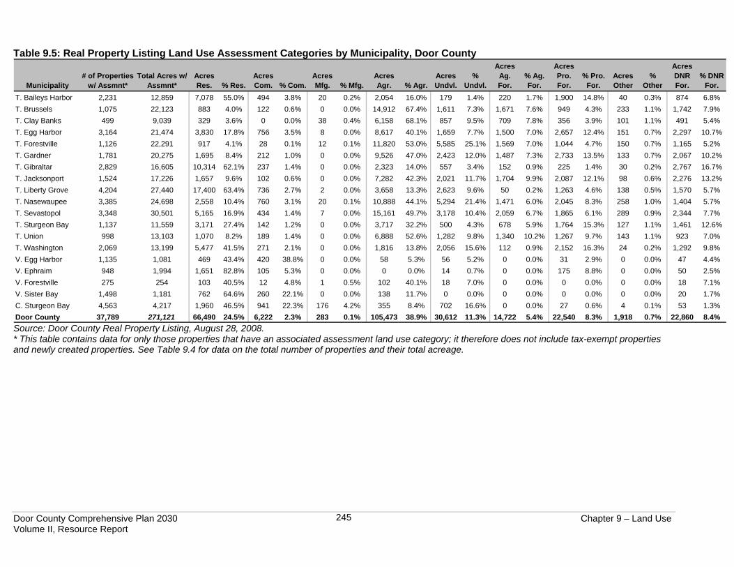
Table 9.5, based on Door County Real Property Listing Department records from August 2008, shows for each municipality and the county the total number of parcels with a DOR land use assessment category and the total acreage of those parcels. Each DOR assessment category column shows the acreage and percentage of municipal land area in that assessment category. Note that Table 9.5 does not show tax-exempt and other properties without a DOR assessment category (i.e., parcels that did not exist on January 1, 2008) – refer back to Table 9.4 for the total number of properties and the total acreage for each municipality. As noted above, a tax parcel may be assessed in more than one category; thus, the total number of acres shown in each assessment category column in Table 9.5 reflects the actual acreage in the municipality containing that assessment category, not the total acreage comprised by all parcels that contain that assessment type. Table 9.5 shows that out of all the assessed land in the county, the three primary categories are “agricultural,” at almost 39%; “residential,” at approximately 25%; and “undeveloped,” at over 11%. “Productive forest” accounts for over 8% of all the assessed land in the county. The remaining 17% or so of the county’s assessed land area is a mixture of assessment types. Note that these assessment categories differ significantly from the land use inventory data, due to the way land is assessed versus how it was inventoried. For example, the “residential” assessment category acreage of 66,490 is markedly greater than the field-surveyed inventory countywide acreage of 15,239 acres (Table 9.2), due to the fact that land that does not fall into any one of the DOR categories defined above is categorized as residential by the assessors. For example, a vacant lot that is not in agricultural production, fallow, or being used for any of the other land use categories is given a “residential” assessment, whether there is a house on it or not. In comparison, the land use inventory survey was conducted based on visual appearance: the same vacant lot that is categorized as “residential” for assessment purposes would have been coded as “open space,” within the natural areas category, for the purpose of the land use inventory. It is useful to look at current assessment category totals in order to have a basis of comparison to historical assessment levels. (As noted previously, due to differing categorization methods, the older land use inventories conducted in the county cannot be compared with the 2007 inventory, so analysis of assessment categories must suffice.) Historical property assessment data, along with discussion on trends in assessment values, are presented later in this chapter.
Door County Comprehensive Plan 2030 Chapter 9 – Land Use Volume II, Resource Report
245
Table 9.5: Real Property Listing Land Use Assessment Categories by Municipality, Door County
Municipality# of Properties
w/ Assmnt*Total Acres w/
Assmnt*Acres Res. % Res.
Acres Com. % Com.
Acres Mfg. % Mfg.
Acres Agr. % Agr.
Acres Undvl.
% Undvl.
Acres Ag. For.
% Ag. For.
Acres Pro. For.
% Pro. For.
Acres Other
% Other
Acres DNR For.
% DNR For.
T. Baileys Harbor 2,231 12,859 7,078 55.0% 494 3.8% 20 0.2% 2,054 16.0% 179 1.4% 220 1.7% 1,900 14.8% 40 0.3% 874 6.8%T. Brussels 1,075 22,123 883 4.0% 122 0.6% 0 0.0% 14,912 67.4% 1,611 7.3% 1,671 7.6% 949 4.3% 233 1.1% 1,742 7.9%T. Clay Banks 499 9,039 329 3.6% 0 0.0% 38 0.4% 6,158 68.1% 857 9.5% 709 7.8% 356 3.9% 101 1.1% 491 5.4%T. Egg Harbor 3,164 21,474 3,830 17.8% 756 3.5% 8 0.0% 8,617 40.1% 1,659 7.7% 1,500 7.0% 2,657 12.4% 151 0.7% 2,297 10.7%T. Forestville 1,126 22,291 917 4.1% 28 0.1% 12 0.1% 11,820 53.0% 5,585 25.1% 1,569 7.0% 1,044 4.7% 150 0.7% 1,165 5.2%T. Gardner 1,781 20,275 1,695 8.4% 212 1.0% 0 0.0% 9,526 47.0% 2,423 12.0% 1,487 7.3% 2,733 13.5% 133 0.7% 2,067 10.2%T. Gibraltar 2,829 16,605 10,314 62.1% 237 1.4% 0 0.0% 2,323 14.0% 557 3.4% 152 0.9% 225 1.4% 30 0.2% 2,767 16.7%T. Jacksonport 1,524 17,226 1,657 9.6% 102 0.6% 0 0.0% 7,282 42.3% 2,021 11.7% 1,704 9.9% 2,087 12.1% 98 0.6% 2,276 13.2%T. Liberty Grove 4,204 27,440 17,400 63.4% 736 2.7% 2 0.0% 3,658 13.3% 2,623 9.6% 50 0.2% 1,263 4.6% 138 0.5% 1,570 5.7%T. Nasewaupee 3,385 24,698 2,558 10.4% 760 3.1% 20 0.1% 10,888 44.1% 5,294 21.4% 1,471 6.0% 2,045 8.3% 258 1.0% 1,404 5.7%T. Sevastopol 3,348 30,501 5,165 16.9% 434 1.4% 7 0.0% 15,161 49.7% 3,178 10.4% 2,059 6.7% 1,865 6.1% 289 0.9% 2,344 7.7%T. Sturgeon Bay 1,137 11,559 3,171 27.4% 142 1.2% 0 0.0% 3,717 32.2% 500 4.3% 678 5.9% 1,764 15.3% 127 1.1% 1,461 12.6%T. Union 998 13,103 1,070 8.2% 189 1.4% 0 0.0% 6,888 52.6% 1,282 9.8% 1,340 10.2% 1,267 9.7% 143 1.1% 923 7.0%T. Washington 2,069 13,199 5,477 41.5% 271 2.1% 0 0.0% 1,816 13.8% 2,056 15.6% 112 0.9% 2,152 16.3% 24 0.2% 1,292 9.8%V. Egg Harbor 1,135 1,081 469 43.4% 420 38.8% 0 0.0% 58 5.3% 56 5.2% 0 0.0% 31 2.9% 0 0.0% 47 4.4%V. Ephraim 948 1,994 1,651 82.8% 105 5.3% 0 0.0% 0 0.0% 14 0.7% 0 0.0% 175 8.8% 0 0.0% 50 2.5%V. Forestville 275 254 103 40.5% 12 4.8% 1 0.5% 102 40.1% 18 7.0% 0 0.0% 0 0.0% 0 0.0% 18 7.1%V. Sister Bay 1,498 1,181 762 64.6% 260 22.1% 0 0.0% 138 11.7% 0 0.0% 0 0.0% 0 0.0% 0 0.0% 20 1.7%C. Sturgeon Bay 4,563 4,217 1,960 46.5% 941 22.3% 176 4.2% 355 8.4% 702 16.6% 0 0.0% 27 0.6% 4 0.1% 53 1.3%Door County 37,789 271,121 66,490 24.5% 6,222 2.3% 283 0.1% 105,473 38.9% 30,612 11.3% 14,722 5.4% 22,540 8.3% 1,918 0.7% 22,860 8.4%Source: Door County Real Property Listing, August 28, 2008. * This table contains data for only those properties that have an associated assessment land use category; it therefore does not include tax-exempt properties and newly created properties. See Table 9.4 for data on the total number of properties and their total acreage.
Door County Comprehensive Plan 2030 Chapter 9 – Land Use Volume II, Resource Report
246
Below is summary information from Table 9.5 regarding the highest percentages of land assessed in each category within individual municipalities.
• Residential - The Village of Ephraim has the highest percentage of property assessed residentially at almost 83%, followed by the Village of Sister Bay at approximately 65% and the Town of Liberty Grove at over 63%.
• Commercial - The Village of Egg Harbor has the highest percentage of commercially assessed property at almost 39%. The City of Sturgeon Bay and the Village of Sister Bay are second and third highest at just over 22%.
• Manufacturing - The City of Sturgeon Bay has the highest percentage of acreage assessed as manufacturing with over 4%. All other municipalities have less than 1% assessed as manufacturing.
• Agriculture - The Towns of Clay Banks and Brussels have the most agriculturally assessed land at over 68% and 67%, respectively, followed by the Town of Forestville at 53%.
• Undeveloped - The Town of Forestville has the highest percentage of undeveloped land at just over 25%, followed by the Town of Nasewaupee at over 21% and the City of Sturgeon Bay at approximately 17%.
• Productive Forest – The Town of Washington has the highest percentage of productive forest at over 16%, followed by the Town of Sturgeon Bay at over 15% and the Town of Baileys Harbor at almost 15%.
• DNR Forest Croplands – The Town of Gibraltar has the highest percentage of DNR forest lands at almost 17%, followed by the Town of Jacksonport at over 13% and the Town of Sturgeon Bay at approximately 13%.
PROPERTY ASSESSMENT VALUES Note: All dollar amounts listed in this section are from the Door County Real Property Geographic Information Systems (GIS) database as of August 28, 2008. Note that unassessed parcels (i.e., newly created during 2008) and tax-exempt properties have an assessment value of zero. The total assessed value in 2007 of Door County real estate for tax purposes, land and improvements, was $6,420,842,080. (The total value for the land in the county was $2,732,574,780 while the total value for the improvements was $3,688,267,300.) LAND VALUES All of the information in this section includes assessed values for land only, exclusive of improvements, although this information does include values for all land, whether vacant or improved. The total assessed value in 2007 of all land in Door County was $2,732,574,780. The following shows the range of assessed land values for all tax parcels in Door County.
• 3,294 (8.1%) parcels had land values of zero. (This number includes 1,774 tax-exempt parcels, as well as common element areas and unassessed properties.)
• 24,628 (60.8%) parcels in Door County had land values between $1 and $50,000. • 7,693 (19%) parcels had land values between $50,001 and $150,000 • 2,576 (6.4%) parcels had land values between $150,001 and $250,000 • 1,700 (4.2%) parcels had land values between $250,001 and $500,000 • 598 (1.5%) had land values of over $500,000
The average value of land on a per acre basis, for all assessed land in Door County was $10,079 in 2007. The Village of Egg Harbor had the highest land value per acre at $85,256, followed by the Village of Sister Bay at $70,699 and the Village of Ephraim at $51,195. The lowest land values per
Door County Comprehensive Plan 2030 Chapter 9 – Land Use Volume II, Resource Report
247
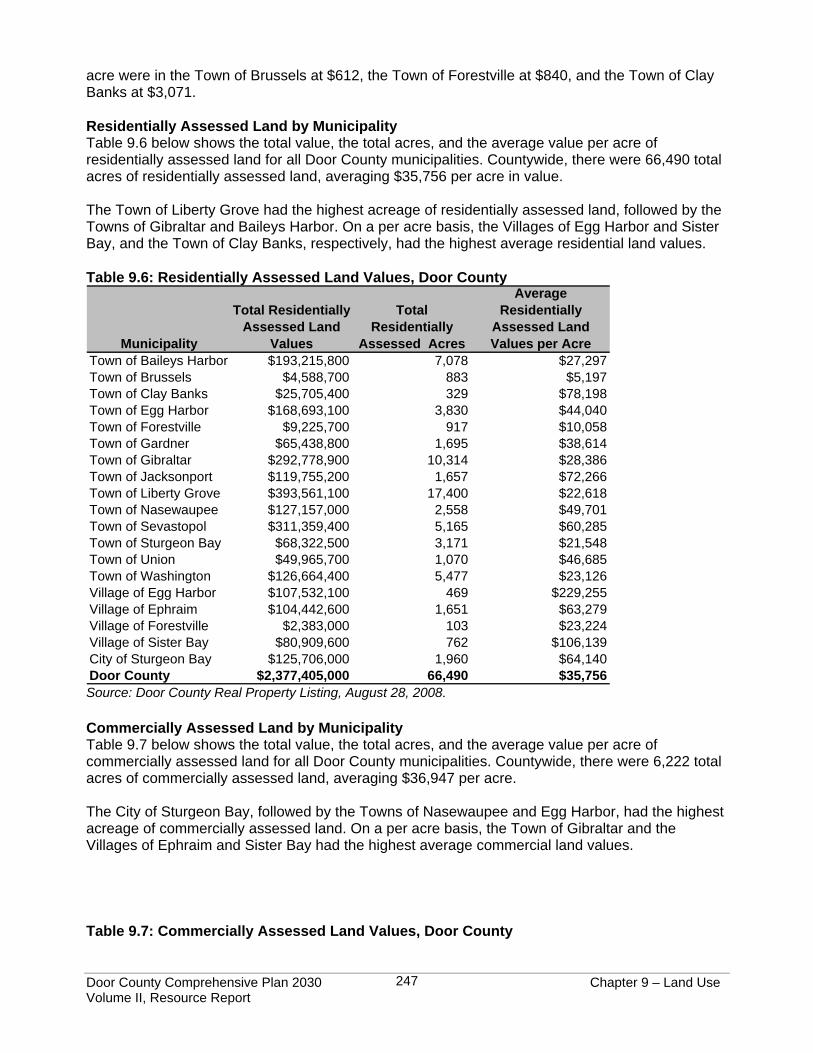
acre were in the Town of Brussels at $612, the Town of Forestville at $840, and the Town of Clay Banks at $3,071. Residentially Assessed Land by Municipality Table 9.6 below shows the total value, the total acres, and the average value per acre of residentially assessed land for all Door County municipalities. Countywide, there were 66,490 total acres of residentially assessed land, averaging $35,756 per acre in value. The Town of Liberty Grove had the highest acreage of residentially assessed land, followed by the Towns of Gibraltar and Baileys Harbor. On a per acre basis, the Villages of Egg Harbor and Sister Bay, and the Town of Clay Banks, respectively, had the highest average residential land values. Table 9.6: Residentially Assessed Land Values, Door County
Municipality
Total Residentially Assessed Land
Values
Total Residentially
Assessed Acres
Average Residentially
Assessed Land Values per Acre
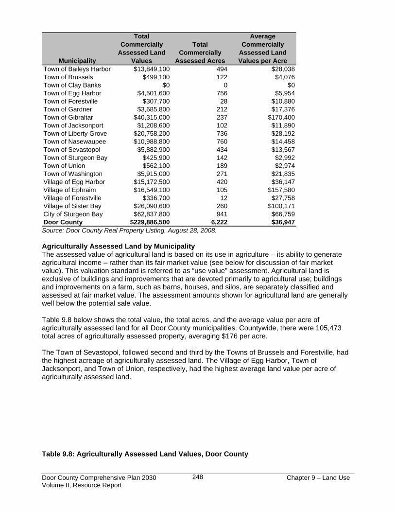
Town of Baileys Harbor $193,215,800 7,078 $27,297Town of Brussels $4,588,700 883 $5,197Town of Clay Banks $25,705,400 329 $78,198Town of Egg Harbor $168,693,100 3,830 $44,040Town of Forestville $9,225,700 917 $10,058Town of Gardner $65,438,800 1,695 $38,614Town of Gibraltar $292,778,900 10,314 $28,386Town of Jacksonport $119,755,200 1,657 $72,266Town of Liberty Grove $393,561,100 17,400 $22,618Town of Nasewaupee $127,157,000 2,558 $49,701Town of Sevastopol $311,359,400 5,165 $60,285Town of Sturgeon Bay $68,322,500 3,171 $21,548Town of Union $49,965,700 1,070 $46,685Town of Washington $126,664,400 5,477 $23,126Village of Egg Harbor $107,532,100 469 $229,255Village of Ephraim $104,442,600 1,651 $63,279Village of Forestville $2,383,000 103 $23,224Village of Sister Bay $80,909,600 762 $106,139City of Sturgeon Bay $125,706,000 1,960 $64,140Door County $2,377,405,000 66,490 $35,756 Source: Door County Real Property Listing, August 28, 2008. Commercially Assessed Land by Municipality Table 9.7 below shows the total value, the total acres, and the average value per acre of commercially assessed land for all Door County municipalities. Countywide, there were 6,222 total acres of commercially assessed land, averaging $36,947 per acre. The City of Sturgeon Bay, followed by the Towns of Nasewaupee and Egg Harbor, had the highest acreage of commercially assessed land. On a per acre basis, the Town of Gibraltar and the Villages of Ephraim and Sister Bay had the highest average commercial land values. Table 9.7: Commercially Assessed Land Values, Door County
Door County Comprehensive Plan 2030 Chapter 9 – Land Use Volume II, Resource Report
248
Municipality
Total Commercially
Assessed Land Values
Total Commercially
Assessed Acres
Average Commercially
Assessed Land Values per Acre
Town of Baileys Harbor $13,849,100 494 $28,038Town of Brussels $499,100 122 $4,076Town of Clay Banks $0 0 $0Town of Egg Harbor $4,501,600 756 $5,954Town of Forestville $307,700 28 $10,880Town of Gardner $3,685,800 212 $17,376Town of Gibraltar $40,315,000 237 $170,400Town of Jacksonport $1,208,600 102 $11,890Town of Liberty Grove $20,758,200 736 $28,192Town of Nasewaupee $10,988,800 760 $14,458Town of Sevastopol $5,882,900 434 $13,567Town of Sturgeon Bay $425,900 142 $2,992Town of Union $562,100 189 $2,974Town of Washington $5,915,000 271 $21,835Village of Egg Harbor $15,172,500 420 $36,147Village of Ephraim $16,549,100 105 $157,580Village of Forestville $336,700 12 $27,758Village of Sister Bay $26,090,600 260 $100,171City of Sturgeon Bay $62,837,800 941 $66,759Door County $229,886,500 6,222 $36,947 Source: Door County Real Property Listing, August 28, 2008. Agriculturally Assessed Land by Municipality The assessed value of agricultural land is based on its use in agriculture – its ability to generate agricultural income – rather than its fair market value (see below for discussion of fair market value). This valuation standard is referred to as “use value” assessment. Agricultural land is exclusive of buildings and improvements that are devoted primarily to agricultural use; buildings and improvements on a farm, such as barns, houses, and silos, are separately classified and assessed at fair market value. The assessment amounts shown for agricultural land are generally well below the potential sale value. Table 9.8 below shows the total value, the total acres, and the average value per acre of agriculturally assessed land for all Door County municipalities. Countywide, there were 105,473 total acres of agriculturally assessed property, averaging $176 per acre. The Town of Sevastopol, followed second and third by the Towns of Brussels and Forestville, had the highest acreage of agriculturally assessed land. The Village of Egg Harbor, Town of Jacksonport, and Town of Union, respectively, had the highest average land value per acre of agriculturally assessed land. Table 9.8: Agriculturally Assessed Land Values, Door County
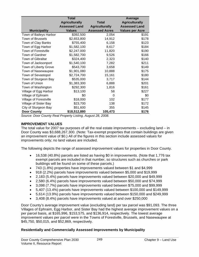
Door County Comprehensive Plan 2030 Chapter 9 – Land Use Volume II, Resource Report
249
Municipality
Total Agriculturally
Assessed Land Values
Total Agriculturally
Assessed Acres
Average Agriculturally
Assessed Land Values per Acre
Town of Baileys Harbor $392,500 2,054 $191Town of Brussels $2,653,800 14,912 $178Town of Clay Banks $755,400 6,158 $123Town of Egg Harbor $1,582,100 8,617 $184Town of Forestville $2,247,000 11,820 $190Town of Gardner $1,582,700 9,526 $166Town of Gibraltar $324,400 2,323 $140Town of Jacksonport $1,540,100 7,282 $211Town of Liberty Grove $543,700 3,658 $149Town of Nasewaupee $1,901,080 10,888 $175Town of Sevastopol $2,724,700 15,161 $180Town of Sturgeon Bay $535,000 3,717 $144Town of Union $1,383,300 6,888 $201Town of Washington $292,300 1,816 $161Village of Egg Harbor $13,100 58 $227Village of Ephraim $0 0 $0Village of Forestville $18,000 102 $177Village of Sister Bay $23,700 138 $172City of Sturgeon Bay $51,600 355 $145Door County $18,512,880 105,473 $176 Source: Door County Real Property Listing, August 28, 2008. IMPROVEMENT VALUES The total value for 2007 tax purposes of all the real estate improvements – excluding land – in Door County was $3,688,267,300. (Note: Tax-exempt properties that contain buildings are given an improvement value of $0.) All of the figures in this section include assessed values for improvements only; no land values are included. The following depicts the range of assessed improvement values for properties in Door County.
• 16,538 (40.8%) parcels are listed as having $0 in improvements. (Note that 1,776 tax exempt parcels are included in that number, so structures such as churches or park buildings will be found on some of these parcels.)
• 743 (1.8%) properties have improvements valued between $1 and $4,999 • 918 (2.2%) parcels have improvements valued between $5,000 and $19,999 • 2,183 (5.4%) parcels have improvements valued between $20,000 and $49,999 • 2,580 (6.4%) parcels have improvements valued between $50,000 and $74,999 • 3,098 (7.7%) parcels have improvements valued between $75,000 and $99,999 • 5,407 (13.4%) parcels have improvements valued between $100,000 and $149,999 • 5,614 (13.9%) parcels have improvements valued between $150,000 and $249,999 • 3,408 (8.4%) parcels have improvements valued at and over $250,000
Door County’s average improvement value (excluding land) per tax parcel was $91,093. The three Villages of Ephraim, Egg Harbor, and Sister Bay had the highest average improvement values on a per parcel basis, at $165,996, $153,575, and $136,914, respectively. The lowest average improvement values per parcel were in the Towns of Forestville, Brussels, and Nasewaupee at $45,750, $50,015, and $52,869, respectively. Residentially and Commercially Assessed Improvements by Municipality
Door County Comprehensive Plan 2030 Chapter 9 – Land Use Volume II, Resource Report
250
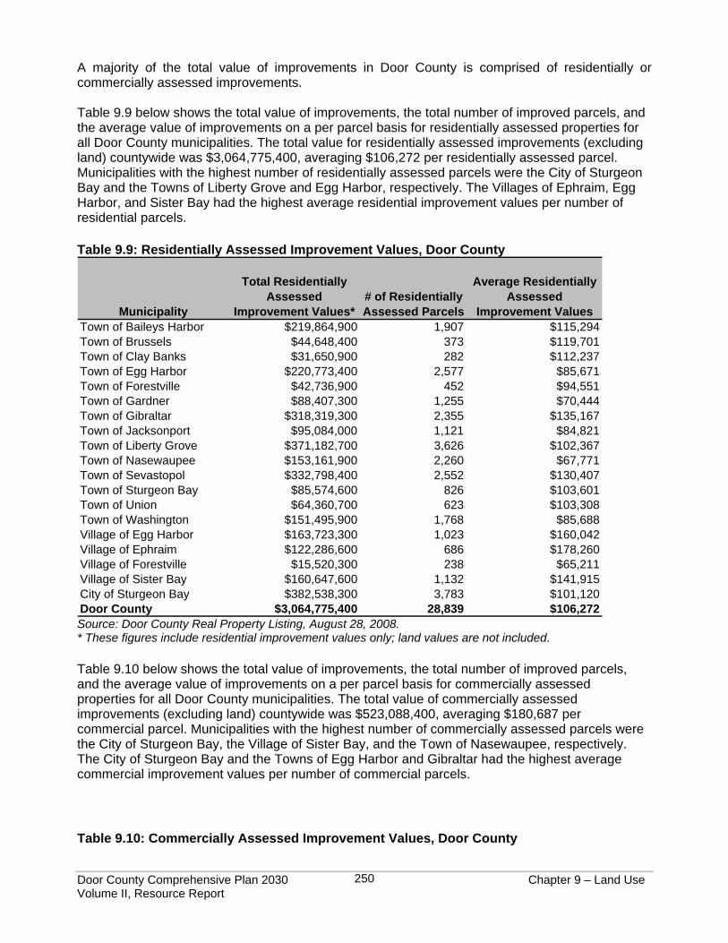
A majority of the total value of improvements in Door County is comprised of residentially or commercially assessed improvements. Table 9.9 below shows the total value of improvements, the total number of improved parcels, and the average value of improvements on a per parcel basis for residentially assessed properties for all Door County municipalities. The total value for residentially assessed improvements (excluding land) countywide was $3,064,775,400, averaging $106,272 per residentially assessed parcel. Municipalities with the highest number of residentially assessed parcels were the City of Sturgeon Bay and the Towns of Liberty Grove and Egg Harbor, respectively. The Villages of Ephraim, Egg Harbor, and Sister Bay had the highest average residential improvement values per number of residential parcels. Table 9.9: Residentially Assessed Improvement Values, Door County
Municipality
Total Residentially Assessed
Improvement Values*# of Residentially Assessed Parcels
Average Residentially Assessed
Improvement ValuesTown of Baileys Harbor $219,864,900 1,907 $115,294Town of Brussels $44,648,400 373 $119,701Town of Clay Banks $31,650,900 282 $112,237Town of Egg Harbor $220,773,400 2,577 $85,671Town of Forestville $42,736,900 452 $94,551Town of Gardner $88,407,300 1,255 $70,444Town of Gibraltar $318,319,300 2,355 $135,167Town of Jacksonport $95,084,000 1,121 $84,821Town of Liberty Grove $371,182,700 3,626 $102,367Town of Nasewaupee $153,161,900 2,260 $67,771Town of Sevastopol $332,798,400 2,552 $130,407Town of Sturgeon Bay $85,574,600 826 $103,601Town of Union $64,360,700 623 $103,308Town of Washington $151,495,900 1,768 $85,688Village of Egg Harbor $163,723,300 1,023 $160,042Village of Ephraim $122,286,600 686 $178,260Village of Forestville $15,520,300 238 $65,211Village of Sister Bay $160,647,600 1,132 $141,915City of Sturgeon Bay $382,538,300 3,783 $101,120Door County $3,064,775,400 28,839 $106,272 Source: Door County Real Property Listing, August 28, 2008. * These figures include residential improvement values only; land values are not included.
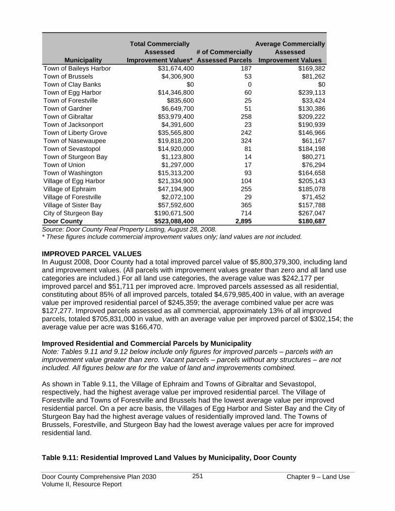
Table 9.10 below shows the total value of improvements, the total number of improved parcels, and the average value of improvements on a per parcel basis for commercially assessed properties for all Door County municipalities. The total value of commercially assessed improvements (excluding land) countywide was $523,088,400, averaging $180,687 per commercial parcel. Municipalities with the highest number of commercially assessed parcels were the City of Sturgeon Bay, the Village of Sister Bay, and the Town of Nasewaupee, respectively. The City of Sturgeon Bay and the Towns of Egg Harbor and Gibraltar had the highest average commercial improvement values per number of commercial parcels. Table 9.10: Commercially Assessed Improvement Values, Door County
Door County Comprehensive Plan 2030 Chapter 9 – Land Use Volume II, Resource Report
251
Municipality
Total Commercially Assessed
Improvement Values*# of Commercially Assessed Parcels
Average Commercially Assessed
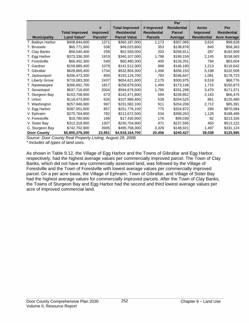
Improvement ValuesTown of Baileys Harbor $31,674,400 187 $169,382Town of Brussels $4,306,900 53 $81,262Town of Clay Banks $0 0 $0Town of Egg Harbor $14,346,800 60 $239,113Town of Forestville $835,600 25 $33,424Town of Gardner $6,649,700 51 $130,386Town of Gibraltar $53,979,400 258 $209,222Town of Jacksonport $4,391,600 23 $190,939Town of Liberty Grove $35,565,800 242 $146,966Town of Nasewaupee $19,818,200 324 $61,167Town of Sevastopol $14,920,000 81 $184,198Town of Sturgeon Bay $1,123,800 14 $80,271Town of Union $1,297,000 17 $76,294Town of Washington $15,313,200 93 $164,658Village of Egg Harbor $21,334,900 104 $205,143Village of Ephraim $47,194,900 255 $185,078Village of Forestville $2,072,100 29 $71,452Village of Sister Bay $57,592,600 365 $157,788City of Sturgeon Bay $190,671,500 714 $267,047Door County $523,088,400 2,895 $180,687 Source: Door County Real Property Listing, August 28, 2008. * These figures include commercial improvement values only; land values are not included. IMPROVED PARCEL VALUES In August 2008, Door County had a total improved parcel value of $5,800,379,300, including land and improvement values. (All parcels with improvement values greater than zero and all land use categories are included.) For all land use categories, the average value was $242,177 per improved parcel and $51,711 per improved acre. Improved parcels assessed as all residential, constituting about 85% of all improved parcels, totaled $4,679,985,400 in value, with an average value per improved residential parcel of $245,359; the average combined value per acre was $127,277. Improved parcels assessed as all commercial, approximately 13% of all improved parcels, totaled $705,831,000 in value, with an average value per improved parcel of $302,154; the average value per acre was $166,470. Improved Residential and Commercial Parcels by Municipality Note: Tables 9.11 and 9.12 below include only figures for improved parcels – parcels with an improvement value greater than zero. Vacant parcels – parcels without any structures – are not included. All figures below are for the value of land and improvements combined. As shown in Table 9.11, the Village of Ephraim and Towns of Gibraltar and Sevastopol, respectively, had the highest average value per improved residential parcel. The Village of Forestville and Towns of Forestville and Brussels had the lowest average value per improved residential parcel. On a per acre basis, the Villages of Egg Harbor and Sister Bay and the City of Sturgeon Bay had the highest average values of residentially improved land. The Towns of Brussels, Forestville, and Sturgeon Bay had the lowest average values per acre for improved residential land. Table 9.11: Residential Improved Land Values by Municipality, Door County
Door County Comprehensive Plan 2030 Chapter 9 – Land Use Volume II, Resource Report
252
MunicipalityTotal Improved
Land Value*
# Improved Parcels*
Total Improved Residential
Parcel Value
# Improved Residential
Parcels
Per Residential
Parcel Average
Acres Improved
Residential
Per Residential
Acre AverageT. Baileys Harbor $408,844,600 1371 $360,187,000 1,173 $307,065 3,615 $99,628T. Brussels $65,771,900 538 $49,023,800 353 $138,878 840 $58,363T. Clay Banks $59,540,400 258 $52,559,000 203 $258,911 287 $182,909T. Egg Harbor $373,336,300 1919 $340,107,000 1,798 $189,159 2,145 $158,563T. Forestville $66,452,300 549 $50,480,300 400 $126,201 794 $63,604T. Gardner $159,885,400 1079 $141,512,000 968 $146,190 1,213 $116,642T. Gibraltar $628,865,400 1734 $532,804,300 1,496 $356,153 5,198 $102,509T. Jacksonport $206,473,300 859 $193,124,700 783 $246,647 1,081 $178,723T. Liberty Grove $719,083,300 2437 $654,621,600 2,175 $300,975 9,518 $68,776T. Nasewaupee $306,661,700 1817 $258,679,500 1,494 $173,146 1,715 $150,873T. Sevastopol $637,716,000 2004 $594,679,500 1,795 $331,298 3,470 $171,371T. Sturgeon Bay $153,708,900 673 $142,471,800 594 $239,852 2,143 $66,475T. Union $118,473,800 626 $107,989,400 528 $204,525 861 $125,480T. Washington $257,946,900 997 $231,582,100 911 $254,206 2,712 $85,391V. Egg Harbor $287,051,600 857 $251,776,100 775 $324,872 289 $870,084V. Ephraim $275,764,900 782 $212,672,500 534 $398,263 1,128 $188,489V. Forestville $19,780,900 199 $17,430,900 176 $99,039 82 $213,326V. Sister Bay $312,318,900 1307 $230,704,900 971 $237,595 450 $513,122C. Sturgeon Bay $742,702,800 3945 $495,758,300 3,329 $148,921 1,497 $331,124Door County $5,800,379,300 23,951 $4,918,164,700 20,456 $240,427 39,038 $125,985Source: Door County Real Property Listing, August 28, 2008. * Includes all types of land uses. As shown in Table 9.12, the Village of Egg Harbor and the Towns of Gibraltar and Egg Harbor, respectively, had the highest average values per commercially improved parcel. The Town of Clay Banks, which did not have any commercially assessed land, was followed by the Village of Forestville and the Town of Forestville with lowest average values per commercially improved parcel. On a per acre basis, the Village of Ephraim, Town of Gibraltar, and Village of Sister Bay had the highest average values for commercially improved parcels. After the Town of Clay Banks, the Towns of Sturgeon Bay and Egg Harbor had the second and third lowest average values per acre of improved commercial land.
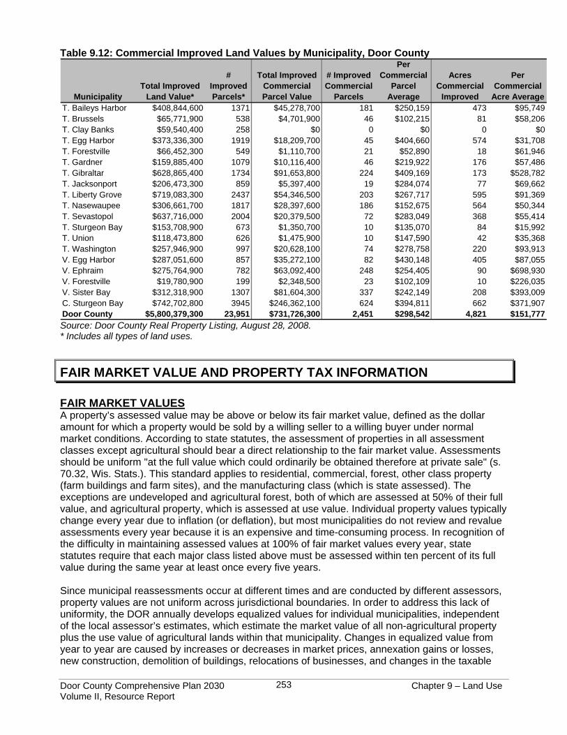
Door County Comprehensive Plan 2030 Chapter 9 – Land Use Volume II, Resource Report
253
Table 9.12: Commercial Improved Land Values by Municipality, Door County
MunicipalityTotal Improved
Land Value*
# Improved Parcels*
Total Improved Commercial Parcel Value
# Improved Commercial
Parcels
Per Commercial
Parcel Average
Acres Commercial
Improved
Per Commercial
Acre AverageT. Baileys Harbor $408,844,600 1371 $45,278,700 181 $250,159 473 $95,749T. Brussels $65,771,900 538 $4,701,900 46 $102,215 81 $58,206T. Clay Banks $59,540,400 258 $0 0 $0 0 $0T. Egg Harbor $373,336,300 1919 $18,209,700 45 $404,660 574 $31,708T. Forestville $66,452,300 549 $1,110,700 21 $52,890 18 $61,946T. Gardner $159,885,400 1079 $10,116,400 46 $219,922 176 $57,486T. Gibraltar $628,865,400 1734 $91,653,800 224 $409,169 173 $528,782T. Jacksonport $206,473,300 859 $5,397,400 19 $284,074 77 $69,662T. Liberty Grove $719,083,300 2437 $54,346,500 203 $267,717 595 $91,369T. Nasewaupee $306,661,700 1817 $28,397,600 186 $152,675 564 $50,344T. Sevastopol $637,716,000 2004 $20,379,500 72 $283,049 368 $55,414T. Sturgeon Bay $153,708,900 673 $1,350,700 10 $135,070 84 $15,992T. Union $118,473,800 626 $1,475,900 10 $147,590 42 $35,368T. Washington $257,946,900 997 $20,628,100 74 $278,758 220 $93,913V. Egg Harbor $287,051,600 857 $35,272,100 82 $430,148 405 $87,055V. Ephraim $275,764,900 782 $63,092,400 248 $254,405 90 $698,930V. Forestville $19,780,900 199 $2,348,500 23 $102,109 10 $226,035V. Sister Bay $312,318,900 1307 $81,604,300 337 $242,149 208 $393,009C. Sturgeon Bay $742,702,800 3945 $246,362,100 624 $394,811 662 $371,907Door County $5,800,379,300 23,951 $731,726,300 2,451 $298,542 4,821 $151,777Source: Door County Real Property Listing, August 28, 2008. * Includes all types of land uses.
FAIR MARKET VALUE AND PROPERTY TAX INFORMATION FAIR MARKET VALUES A property’s assessed value may be above or below its fair market value, defined as the dollar amount for which a property would be sold by a willing seller to a willing buyer under normal market conditions. According to state statutes, the assessment of properties in all assessment classes except agricultural should bear a direct relationship to the fair market value. Assessments should be uniform "at the full value which could ordinarily be obtained therefore at private sale" (s. 70.32, Wis. Stats.). This standard applies to residential, commercial, forest, other class property (farm buildings and farm sites), and the manufacturing class (which is state assessed). The exceptions are undeveloped and agricultural forest, both of which are assessed at 50% of their full value, and agricultural property, which is assessed at use value. Individual property values typically change every year due to inflation (or deflation), but most municipalities do not review and revalue assessments every year because it is an expensive and time-consuming process. In recognition of the difficulty in maintaining assessed values at 100% of fair market values every year, state statutes require that each major class listed above must be assessed within ten percent of its full value during the same year at least once every five years. Since municipal reassessments occur at different times and are conducted by different assessors, property values are not uniform across jurisdictional boundaries. In order to address this lack of uniformity, the DOR annually develops equalized values for individual municipalities, independent of the local assessor’s estimates, which estimate the market value of all non-agricultural property plus the use value of agricultural lands within that municipality. Changes in equalized value from year to year are caused by increases or decreases in market prices, annexation gains or losses, new construction, demolition of buildings, relocations of businesses, and changes in the taxable
Door County Comprehensive Plan 2030 Chapter 9 – Land Use Volume II, Resource Report
254
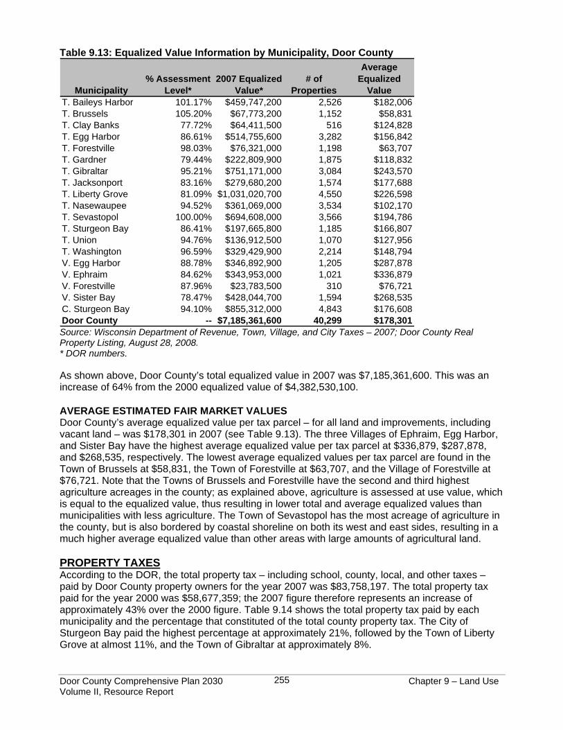
status of property. Equalized values are developed using analysis of 1) sales, 2) use value, 3) property appraisals, 4) local reports, and 5) s. 70.57, Wis. Stats., Corrections. These methods are explained in detail in Wisconsin’s Equalized Values: The Uniform Valuation of Taxable Property, listed in the Resources and Further Information section at the end of this chapter. Estimating equalized values allows the DOR to establish fair market values between municipalities across the state without having to assess every property individually. Local assessors estimate the value of each parcel within a municipality; the DOR estimates the value of the entire city, village, or town. If locally assessed values were used to allocate county taxes, municipal assessors would have an incentive to deliberately under-value property in order to decrease the burden on their taxpayers. Thus, in order to allocate both taxes and state aids fairly, equalization is needed to measure taxable values in all municipalities using the same yardstick. Equalized values are used by the state for a variety of purposes, including the apportionment of certain property tax levies, allocation of state aids to local governments, and calculation of allowable debt. The apportionment of the county property tax levy to individual municipalities involves the calculation of an average assessment level. A municipality’s total equalized value for all major assessment classes in relationship to its total assessed value is called the assessment level, and is derived by dividing the municipality’s total assessed value by its total equalized value. Table 9.13 shows assessment levels and equalized values for each Door County municipality in 2007. For example, the total assessed value for the Town of Baileys Harbor in 2007 was $465,126,242 and the equalized value was $459,747,200; Baileys Harbor’s assessment level was therefore 101.17% ($465,126,242 divided by $459,747,200). The apportionment of the county property tax levy to individual property owners involves applying an assessment ratio to the assessed value of a property to determine its estimated fair market value (EFMV). (An assessment ratio is the same as the municipality’s assessment level, but the difference is in the usage of these terms – “level” is usually used to refer to the taxation district and “ratio” to the individual parcel.) The EFMV of an individual property is derived by taking the property’s total assessed value and dividing it by that municipality’s assessment level. For example, the EFMV of a parcel’s assessed valued at $200,000 in the Town of Baileys Harbor would be $197,687 ($200,000 divided by 101.17%). The EFMV is the number which is then used in calculating the property tax owed for this parcel.
Door County Comprehensive Plan 2030 Chapter 9 – Land Use Volume II, Resource Report
255
Table 9.13: Equalized Value Information by Municipality, Door County
Municipality% Assessment
Level*2007 Equalized
Value*# of
Properties
Average Equalized
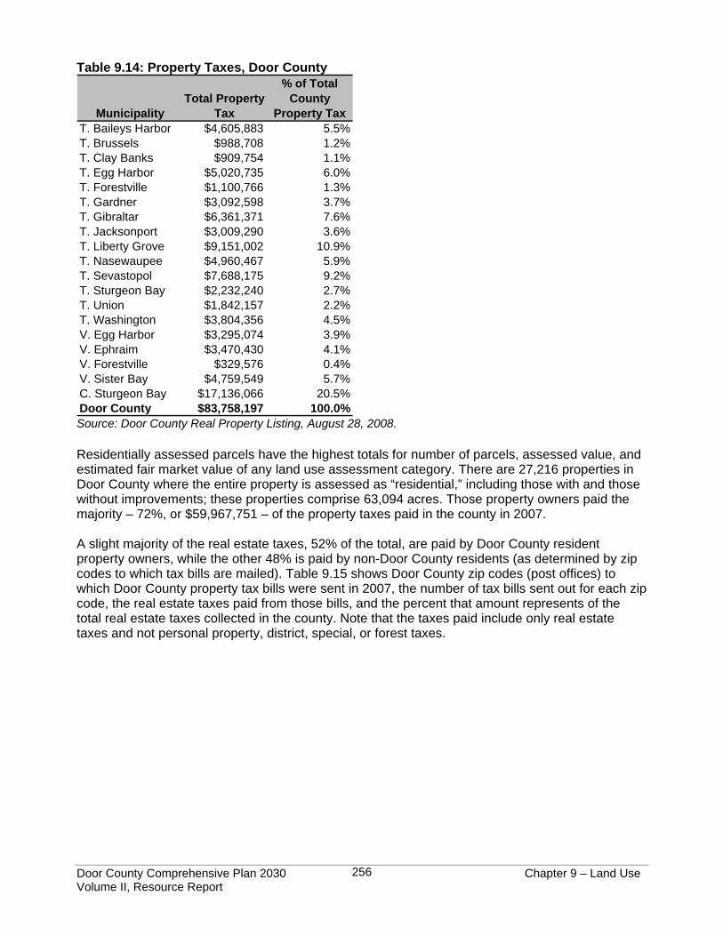
ValueT. Baileys Harbor 101.17% $459,747,200 2,526 $182,006T. Brussels 105.20% $67,773,200 1,152 $58,831T. Clay Banks 77.72% $64,411,500 516 $124,828T. Egg Harbor 86.61% $514,755,600 3,282 $156,842T. Forestville 98.03% $76,321,000 1,198 $63,707T. Gardner 79.44% $222,809,900 1,875 $118,832T. Gibraltar 95.21% $751,171,000 3,084 $243,570T. Jacksonport 83.16% $279,680,200 1,574 $177,688T. Liberty Grove 81.09% $1,031,020,700 4,550 $226,598T. Nasewaupee 94.52% $361,069,000 3,534 $102,170T. Sevastopol 100.00% $694,608,000 3,566 $194,786T. Sturgeon Bay 86.41% $197,665,800 1,185 $166,807T. Union 94.76% $136,912,500 1,070 $127,956T. Washington 96.59% $329,429,900 2,214 $148,794V. Egg Harbor 88.78% $346,892,900 1,205 $287,878V. Ephraim 84.62% $343,953,000 1,021 $336,879V. Forestville 87.96% $23,783,500 310 $76,721V. Sister Bay 78.47% $428,044,700 1,594 $268,535C. Sturgeon Bay 94.10% $855,312,000 4,843 $176,608Door County -- $7,185,361,600 40,299 $178,301 Source: Wisconsin Department of Revenue, Town, Village, and City Taxes – 2007; Door County Real Property Listing, August 28, 2008. * DOR numbers. As shown above, Door County’s total equalized value in 2007 was $7,185,361,600. This was an increase of 64% from the 2000 equalized value of $4,382,530,100. AVERAGE ESTIMATED FAIR MARKET VALUES Door County’s average equalized value per tax parcel – for all land and improvements, including vacant land – was $178,301 in 2007 (see Table 9.13). The three Villages of Ephraim, Egg Harbor, and Sister Bay have the highest average equalized value per tax parcel at $336,879, $287,878, and $268,535, respectively. The lowest average equalized values per tax parcel are found in the Town of Brussels at $58,831, the Town of Forestville at $63,707, and the Village of Forestville at $76,721. Note that the Towns of Brussels and Forestville have the second and third highest agriculture acreages in the county; as explained above, agriculture is assessed at use value, which is equal to the equalized value, thus resulting in lower total and average equalized values than municipalities with less agriculture. The Town of Sevastopol has the most acreage of agriculture in the county, but is also bordered by coastal shoreline on both its west and east sides, resulting in a much higher average equalized value than other areas with large amounts of agricultural land. PROPERTY TAXES According to the DOR, the total property tax – including school, county, local, and other taxes – paid by Door County property owners for the year 2007 was $83,758,197. The total property tax paid for the year 2000 was $58,677,359; the 2007 figure therefore represents an increase of approximately 43% over the 2000 figure. Table 9.14 shows the total property tax paid by each municipality and the percentage that constituted of the total county property tax. The City of Sturgeon Bay paid the highest percentage at approximately 21%, followed by the Town of Liberty Grove at almost 11%, and the Town of Gibraltar at approximately 8%.
Door County Comprehensive Plan 2030 Chapter 9 – Land Use Volume II, Resource Report
256
Table 9.14: Property Taxes, Door County
MunicipalityTotal Property
Tax
% of Total County
Property TaxT. Baileys Harbor $4,605,883 5.5%T. Brussels $988,708 1.2%T. Clay Banks $909,754 1.1%T. Egg Harbor $5,020,735 6.0%T. Forestville $1,100,766 1.3%T. Gardner $3,092,598 3.7%T. Gibraltar $6,361,371 7.6%T. Jacksonport $3,009,290 3.6%T. Liberty Grove $9,151,002 10.9%T. Nasewaupee $4,960,467 5.9%T. Sevastopol $7,688,175 9.2%T. Sturgeon Bay $2,232,240 2.7%T. Union $1,842,157 2.2%T. Washington $3,804,356 4.5%V. Egg Harbor $3,295,074 3.9%V. Ephraim $3,470,430 4.1%V. Forestville $329,576 0.4%V. Sister Bay $4,759,549 5.7%C. Sturgeon Bay $17,136,066 20.5%Door County $83,758,197 100.0% Source: Door County Real Property Listing, August 28, 2008. Residentially assessed parcels have the highest totals for number of parcels, assessed value, and estimated fair market value of any land use assessment category. There are 27,216 properties in Door County where the entire property is assessed as “residential,” including those with and those without improvements; these properties comprise 63,094 acres. Those property owners paid the majority – 72%, or $59,967,751 – of the property taxes paid in the county in 2007. A slight majority of the real estate taxes, 52% of the total, are paid by Door County resident property owners, while the other 48% is paid by non-Door County residents (as determined by zip codes to which tax bills are mailed). Table 9.15 shows Door County zip codes (post offices) to which Door County property tax bills were sent in 2007, the number of tax bills sent out for each zip code, the real estate taxes paid from those bills, and the percent that amount represents of the total real estate taxes collected in the county. Note that the taxes paid include only real estate taxes and not personal property, district, special, or forest taxes.
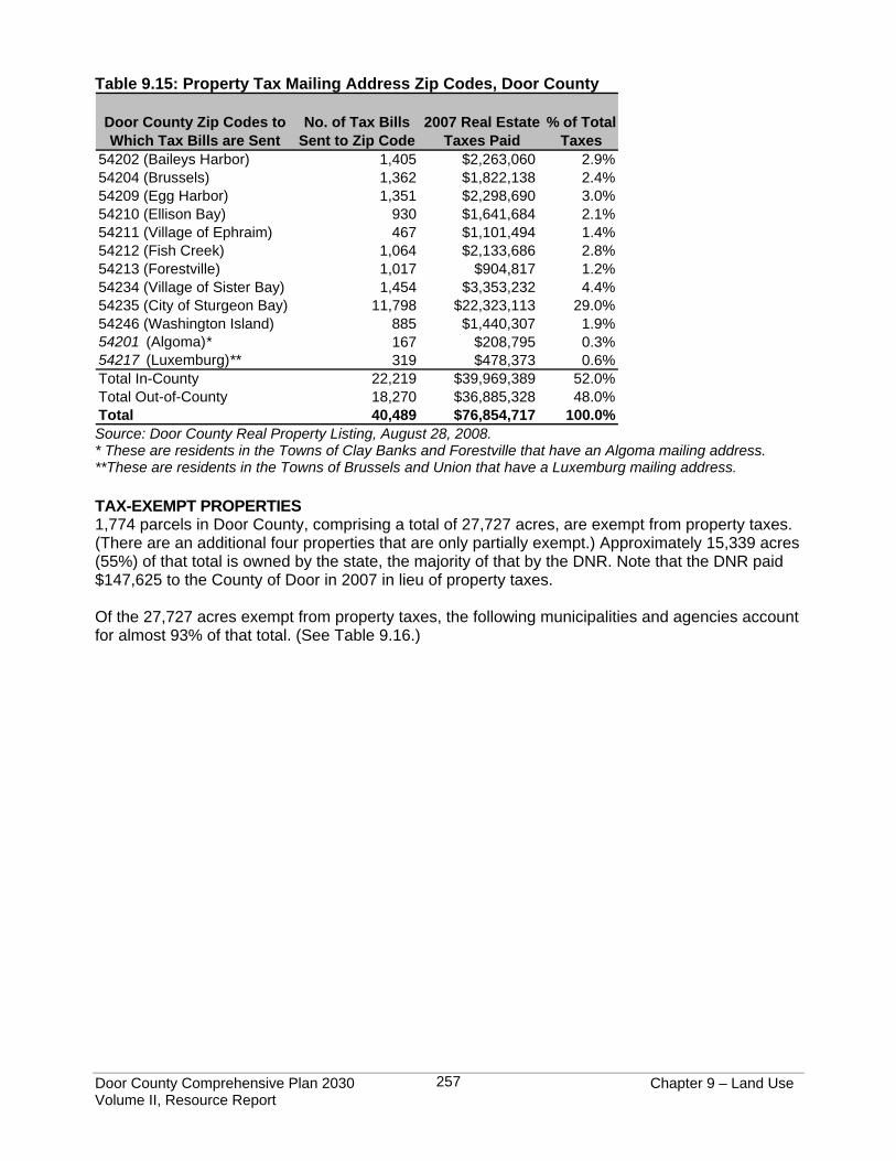
Door County Comprehensive Plan 2030 Chapter 9 – Land Use Volume II, Resource Report
257
Table 9.15: Property Tax Mailing Address Zip Codes, Door County
Door County Zip Codes to Which Tax Bills are Sent
No. of Tax Bills Sent to Zip Code
2007 Real Estate Taxes Paid
% of Total Taxes
54202 (Baileys Harbor) 1,405 $2,263,060 2.9%54204 (Brussels) 1,362 $1,822,138 2.4%54209 (Egg Harbor) 1,351 $2,298,690 3.0%54210 (Ellison Bay) 930 $1,641,684 2.1%54211 (Village of Ephraim) 467 $1,101,494 1.4%54212 (Fish Creek) 1,064 $2,133,686 2.8%54213 (Forestville) 1,017 $904,817 1.2%54234 (Village of Sister Bay) 1,454 $3,353,232 4.4%54235 (City of Sturgeon Bay) 11,798 $22,323,113 29.0%54246 (Washington Island) 885 $1,440,307 1.9%54201 (Algoma)* 167 $208,795 0.3%54217 (Luxemburg)** 319 $478,373 0.6%Total In-County 22,219 $39,969,389 52.0%Total Out-of-County 18,270 $36,885,328 48.0%Total 40,489 $76,854,717 100.0% Source: Door County Real Property Listing, August 28, 2008. * These are residents in the Towns of Clay Banks and Forestville that have an Algoma mailing address. **These are residents in the Towns of Brussels and Union that have a Luxemburg mailing address. TAX-EXEMPT PROPERTIES 1,774 parcels in Door County, comprising a total of 27,727 acres, are exempt from property taxes. (There are an additional four properties that are only partially exempt.) Approximately 15,339 acres (55%) of that total is owned by the state, the majority of that by the DNR. Note that the DNR paid $147,625 to the County of Door in 2007 in lieu of property taxes. Of the 27,727 acres exempt from property taxes, the following municipalities and agencies account for almost 93% of that total. (See Table 9.16.)

Door County Comprehensive Plan 2030 Chapter 9 – Land Use Volume II, Resource Report
258
Table 9.16: Tax-Exempt Properties, Door County Municipality/Agency Acres
Town of Baileys Harbor 61Town of Brussels 26Town of Clay Banks 83Town of Egg Harbor 8Town of Forestville 8Town of Gardner 6Town of Gibraltar 89Town of Jacksonport 59Town of Liberty Grove 150Town of Nasewaupee 20Town of Sevastopol 46Town of Sturgeon Bay 33Town of Union 5Town of Washington 379Village of Egg Harbor 58Village of Ephraim 92Village of Forestville 28Village of Sister Bay 249City of Sturgeon Bay 659County of Door 1,781State of Wisconsin 15,382United States 407Door County Land Trust 1,135Ridges Sanctuary 1,455The Nature Conservancy 3,644Other 1,868Total 27,732 Source: Door County Real Property Listing, August 28, 2008.
Door County Comprehensive Plan 2030 Chapter 9 – Land Use Volume II, Resource Report
259
TRENDS IN PROPERTY ASSESSMENT, MARKET VALUE, AND DEMAND AND SUPPLY OVERALL TRENDS IN PROPERTY ASSESSMENT Note: All figures listed in this section are from the Door County Real Property Listing database for the years cited.
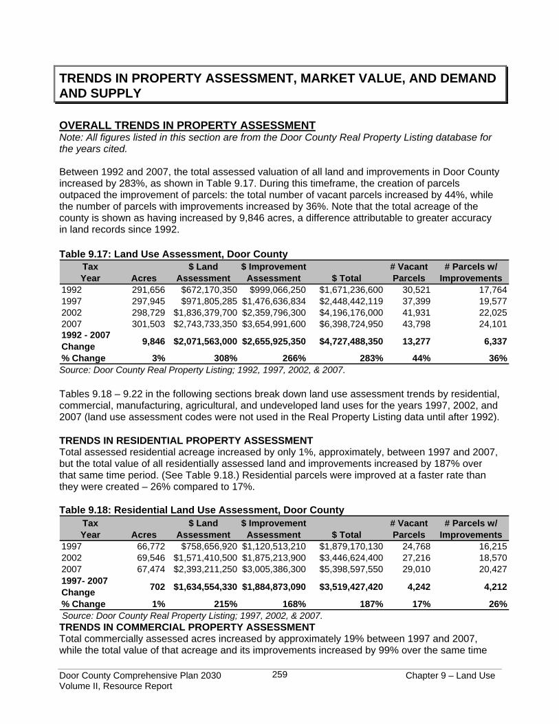
Between 1992 and 2007, the total assessed valuation of all land and improvements in Door County increased by 283%, as shown in Table 9.17. During this timeframe, the creation of parcels outpaced the improvement of parcels: the total number of vacant parcels increased by 44%, while the number of parcels with improvements increased by 36%. Note that the total acreage of the county is shown as having increased by 9,846 acres, a difference attributable to greater accuracy in land records since 1992. Table 9.17: Land Use Assessment, Door County
TaxYear Acres
$ LandAssessment
$ ImprovementAssessment $ Total
# Vacant Parcels
# Parcels w/ Improvements
1992 291,656 $672,170,350 $999,066,250 $1,671,236,600 30,521 17,7641997 297,945 $971,805,285 $1,476,636,834 $2,448,442,119 37,399 19,5772002 298,729 $1,836,379,700 $2,359,796,300 $4,196,176,000 41,931 22,0252007 301,503 $2,743,733,350 $3,654,991,600 $6,398,724,950 43,798 24,1011992 - 2007 Change 9,846 $2,071,563,000 $2,655,925,350 $4,727,488,350 13,277 6,337
% Change 3% 308% 266% 283% 44% 36%Source: Door County Real Property Listing; 1992, 1997, 2002, & 2007. Tables 9.18 – 9.22 in the following sections break down land use assessment trends by residential, commercial, manufacturing, agricultural, and undeveloped land uses for the years 1997, 2002, and 2007 (land use assessment codes were not used in the Real Property Listing data until after 1992). TRENDS IN RESIDENTIAL PROPERTY ASSESSMENT Total assessed residential acreage increased by only 1%, approximately, between 1997 and 2007, but the total value of all residentially assessed land and improvements increased by 187% over that same time period. (See Table 9.18.) Residential parcels were improved at a faster rate than they were created – 26% compared to 17%. Table 9.18: Residential Land Use Assessment, Door County
TaxYear Acres
$ LandAssessment
$ ImprovementAssessment $ Total
# Vacant Parcels
# Parcels w/ Improvements
1997 66,772 $758,656,920 $1,120,513,210 $1,879,170,130 24,768 16,2152002 69,546 $1,571,410,500 $1,875,213,900 $3,446,624,400 27,216 18,5702007 67,474 $2,393,211,250 $3,005,386,300 $5,398,597,550 29,010 20,4271997- 2007 Change 702 $1,634,554,330 $1,884,873,090 $3,519,427,420 4,242 4,212
% Change 1% 215% 168% 187% 17% 26% Source: Door County Real Property Listing; 1997, 2002, & 2007. TRENDS IN COMMERCIAL PROPERTY ASSESSMENT Total commercially assessed acres increased by approximately 19% between 1997 and 2007, while the total value of that acreage and its improvements increased by 99% over the same time

Door County Comprehensive Plan 2030 Chapter 9 – Land Use Volume II, Resource Report
260
period. (See Table 9.19.) The rate at which commercial parcels were improved, or converted from a different use, occurred at the same rate as commercial parcels were created (38%). Note that the rate at which residential property and improvement values increased was nearly double the rate at which commercial property and improvement values increased – 187% versus 99%, respectively. Table 9.19: Commercial Land Use Assessment, Door County
TaxYear Acres
$ LandAssessment
$ ImprovementAssessment $ Total
# Vacant Parcels
# Parcels w/ Improvements
1997 5,281 $117,365,600 $263,248,924 $380,614,524 2,135 1,8142002 5,985 $177,447,500 $380,061,900 $557,509,400 2,554 2,1492007 6,305 $235,803,700 $522,192,600 $757,996,300 2,947 2,4951997- 2007 Change 1,024 $118,438,100 $258,943,676 $377,381,776 812 681
% Change 19% 101% 98% 99% 38% 38%Source: Door County Real Property Listing; 1997, 2002, & 2007. TRENDS IN MANUFACTURING PROPERTY ASSESSMENT The total acreage and value of manufacturing property and improvements decreased by 37% and 9%, respectively, between 1997 and 2007. (See Table 9.20.) Both the number of vacant parcels and the number of improved parcels dropped, by 23% and 30%, respectively. Note that parcels with a discontinued manufacturing use are typically re-assessed as commercial by the municipal assessor. Table 9.20: Manufacturing Land Use Assessment, Door County
TaxYear Acres
$ LandAssessment
$ ImprovementAssessment $ Total
# Vacant Parcels
# Parcels w/ Improvements
1997 472 $5,726,200 $28,306,800 $34,033,000 60 562002 405 $3,518,300 $22,734,000 $26,252,300 56 502007 298 $5,116,600 $25,746,100 $30,862,700 46 391997- 2007 Change -174 -$609,600 -$2,560,700 -$3,170,300 -14 -17
% Change -37% -11% -9% -9% -23% -30%Source: Door County Real Property Listing; 1997, 2002, & 2007. TRENDS IN AGRICULTURAL PROPERTY ASSESSMENT According to the Real Property Listing database, the total acreage of assessed agricultural land in Door County declined by 16% between 1997 and 2007, while the total number of agricultural parcels dropped by 2%. (See Table 9.21.) For that same time period, the total value of agriculturally assessed land decreased by 69%. Note that the significant drop in value is largely, if not entirely, due to the use-value assessment law (discussed previously and below). The total acreage of agricultural land in Door County according to the Real Property Listing database is significantly less than the total acreage provided by the United States Department of Agriculture (USDA) Census of Agriculture for the years 1997 and 2002. As discussed in Chapter 4, Agricultural and Natural Resources, the USDA reported 121,879 acres of agriculture in 1997 and 135,128 acres in 2002, as compared to the Real Property Listing figures of 125,945 acres in 1997 and 113,351 acres in 2002. These differences are largely due to the change in the way agricultural uses are designated by assessors, as mandated by the use value assessment law. Prior to 1997, all agricultural land, whether currently in production or fallow, would be classified as agriculture. Since 1997-1998, when the use value assessment law became effective, only land currently in production is

Door County Comprehensive Plan 2030 Chapter 9 – Land Use Volume II, Resource Report
261
categorized as agricultural; fallow agricultural land is categorized as undeveloped. (This change in assessment practice is also reflected in Table 9.21 below, which shows a significant increase in the total acreage of undeveloped land.) On the other hand, the USDA Census of Agriculture, administered every five years (the 2007 results have not been published to date), counts land that is fallow, but could be tilled at any time for production, as agricultural. Table 9.21: Agricultural Land Use Assessment, Door County
TaxYear Acres
$ LandAssessment # Parcels
1997 125,945 $58,585,365 5,0472002 113,351 $23,493,300 4,7582007 106,103 $18,345,600 4,9601997- 2007 Change -19,842 -$40,239,765 -87
% Change -16% -69% -2% Source: Door County Real Property Listing; 1997, 2002, & 2007. TRENDS IN UNDEVELOPED PROPERTY ASSESSMENT For assessment purposes, undeveloped land includes swampland/wetland, land that cannot be put into production due to soil or site conditions, and fallow agricultural land. As shown in Table 9.22, below, the total acreage of undeveloped land in the county increased by 130% between 1997 and 2007, while the number of parcels increased by 243%. As discussed above, these increases are largely due to the agricultural use-value law that took effect in 1997-1998, which requires categorization of fallow agricultural lands as “undeveloped.” Table 9.22: Undeveloped Land Use Assessment, Door County
TaxYear Acres
$ LandAssessment # Parcels
1997 13,409 $2,759,300 1,2212002 22,328 $11,754,200 3,2952007 30,888 $22,540,500 4,1931997- 2007 Change 17,479 $19,781,200 2,972
% Change 130% 717% 243% Source: Door County Real Property Listing; 1997, 2002, & 2007. MULTIPLE LISTING SERVICE MARKET VALUES Roughly 90% of all real estate sold in Door County is listed with the Door County Board of REALTORS® Multiple Listing Service (MLS). Examination of MLS records, therefore, provides an accurate indication as to actual market values (rather than assessed) and trends for real estate in the county. All of the following information was taken or calculated using information from the MLS for the dates cited. All figures from the MLS are for Door County real estate sold, except for the information on recent active listings. OVERALL INFORMATION Table 9.23 shows the number of MLS properties sold in Door County for the years 2003 – 2007. Sales increased from 2003 – 2005 and then began dropping in 2006 and 2007 both in terms of the number of properties sold and the total value of the selling prices. Even so, the total number of
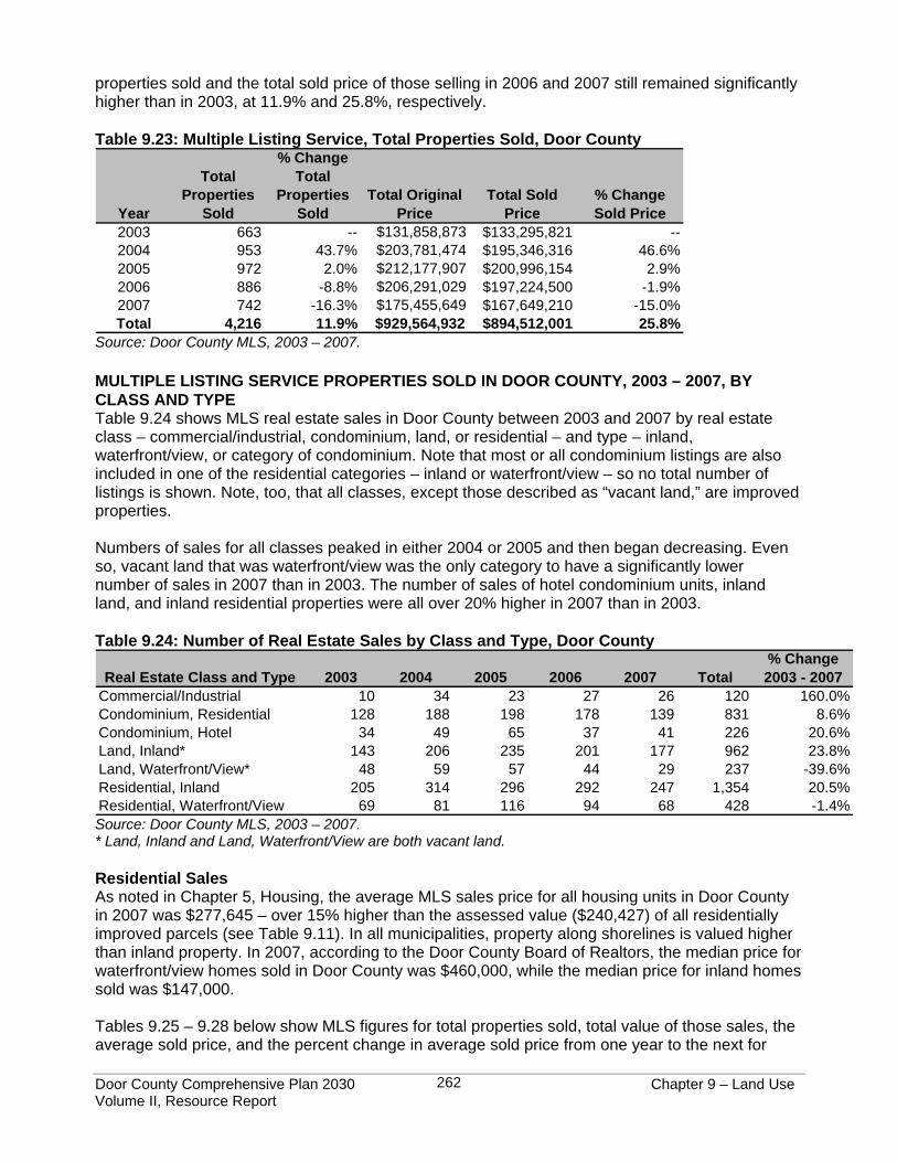
Door County Comprehensive Plan 2030 Chapter 9 – Land Use Volume II, Resource Report
262
properties sold and the total sold price of those selling in 2006 and 2007 still remained significantly higher than in 2003, at 11.9% and 25.8%, respectively. Table 9.23: Multiple Listing Service, Total Properties Sold, Door County
Year
Total Properties
Sold
% Change Total
Properties Sold
Total Original Price
Total Sold Price
% Change Sold Price
2003 663 -- $131,858,873 $133,295,821 --2004 953 43.7% $203,781,474 $195,346,316 46.6%2005 972 2.0% $212,177,907 $200,996,154 2.9%2006 886 -8.8% $206,291,029 $197,224,500 -1.9%2007 742 -16.3% $175,455,649 $167,649,210 -15.0%Total 4,216 11.9% $929,564,932 $894,512,001 25.8%
Source: Door County MLS, 2003 – 2007. MULTIPLE LISTING SERVICE PROPERTIES SOLD IN DOOR COUNTY, 2003 – 2007, BY CLASS AND TYPE Table 9.24 shows MLS real estate sales in Door County between 2003 and 2007 by real estate class – commercial/industrial, condominium, land, or residential – and type – inland, waterfront/view, or category of condominium. Note that most or all condominium listings are also included in one of the residential categories – inland or waterfront/view – so no total number of listings is shown. Note, too, that all classes, except those described as “vacant land,” are improved properties. Numbers of sales for all classes peaked in either 2004 or 2005 and then began decreasing. Even so, vacant land that was waterfront/view was the only category to have a significantly lower number of sales in 2007 than in 2003. The number of sales of hotel condominium units, inland land, and inland residential properties were all over 20% higher in 2007 than in 2003. Table 9.24: Number of Real Estate Sales by Class and Type, Door County
Real Estate Class and Type 2003 2004 2005 2006 2007 Total% Change 2003 - 2007
Commercial/Industrial 10 34 23 27 26 120 160.0%Condominium, Residential 128 188 198 178 139 831 8.6%Condominium, Hotel 34 49 65 37 41 226 20.6%Land, Inland* 143 206 235 201 177 962 23.8%Land, Waterfront/View* 48 59 57 44 29 237 -39.6%Residential, Inland 205 314 296 292 247 1,354 20.5%Residential, Waterfront/View 69 81 116 94 68 428 -1.4%Source: Door County MLS, 2003 – 2007. * Land, Inland and Land, Waterfront/View are both vacant land. Residential Sales As noted in Chapter 5, Housing, the average MLS sales price for all housing units in Door County in 2007 was $277,645 – over 15% higher than the assessed value ($240,427) of all residentially improved parcels (see Table 9.11). In all municipalities, property along shorelines is valued higher than inland property. In 2007, according to the Door County Board of Realtors, the median price for waterfront/view homes sold in Door County was $460,000, while the median price for inland homes sold was $147,000. Tables 9.25 – 9.28 below show MLS figures for total properties sold, total value of those sales, the average sold price, and the percent change in average sold price from one year to the next for
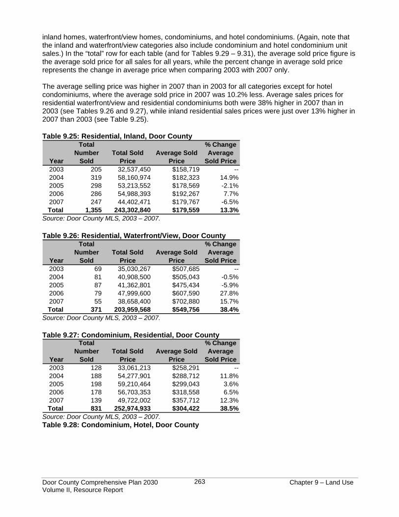
Door County Comprehensive Plan 2030 Chapter 9 – Land Use Volume II, Resource Report
263
inland homes, waterfront/view homes, condominiums, and hotel condominiums. (Again, note that the inland and waterfront/view categories also include condominium and hotel condominium unit sales.) In the “total” row for each table (and for Tables 9.29 – 9.31), the average sold price figure is the average sold price for all sales for all years, while the percent change in average sold price represents the change in average price when comparing 2003 with 2007 only. The average selling price was higher in 2007 than in 2003 for all categories except for hotel condominiums, where the average sold price in 2007 was 10.2% less. Average sales prices for residential waterfront/view and residential condominiums both were 38% higher in 2007 than in 2003 (see Tables 9.26 and 9.27), while inland residential sales prices were just over 13% higher in 2007 than 2003 (see Table 9.25). Table 9.25: Residential, Inland, Door County
Year
Total Number
SoldTotal Sold
PriceAverage Sold
Price
% Change Average
Sold Price2003 205 32,537,450 $158,719 --2004 319 58,160,974 $182,323 14.9%2005 298 53,213,552 $178,569 -2.1%2006 286 54,988,393 $192,267 7.7%2007 247 44,402,471 $179,767 -6.5%Total 1,355 243,302,840 $179,559 13.3%
Source: Door County MLS, 2003 – 2007. Table 9.26: Residential, Waterfront/View, Door County
Year
Total Number
SoldTotal Sold
PriceAverage Sold
Price
% Change Average
Sold Price2003 69 35,030,267 $507,685 --2004 81 40,908,500 $505,043 -0.5%2005 87 41,362,801 $475,434 -5.9%2006 79 47,999,600 $607,590 27.8%2007 55 38,658,400 $702,880 15.7%Total 371 203,959,568 $549,756 38.4%
Source: Door County MLS, 2003 – 2007. Table 9.27: Condominium, Residential, Door County
Year
Total Number
SoldTotal Sold
PriceAverage Sold
Price
% Change Average
Sold Price2003 128 33,061,213 $258,291 --2004 188 54,277,901 $288,712 11.8%2005 198 59,210,464 $299,043 3.6%2006 178 56,703,353 $318,558 6.5%2007 139 49,722,002 $357,712 12.3%Total 831 252,974,933 $304,422 38.5%
Source: Door County MLS, 2003 – 2007. Table 9.28: Condominium, Hotel, Door County
Door County Comprehensive Plan 2030 Chapter 9 – Land Use Volume II, Resource Report
264
Year
Total Number
SoldTotal Sold
PriceAverage Sold
Price
% Change Average
Sold Price2003 32 3,671,300 $114,728 --2004 49 5,715,850 $116,650 1.7%2005 64 7,095,050 $110,860 -5.0%2006 37 4,437,050 $119,920 8.2%2007 41 4,225,949 $103,072 -14.0%Total 223 25,145,199 $112,759 -10.2%
Source: Door County MLS, 2003 – 2007. Commercial/Industrial Sales Table 9.29 shows that the average MLS sales price for commercial/industrial property in 2007 was $246,188 – approximately 18% lower than the assessed value ($298,542) of all commercial improved parcels (see Table 9.12). However, the overall average MLS sales price of $325,664 for commercial property sold between 2003 and 2007 was 9% higher than the assessed value of all commercial improved parcels. Note that the number of sales in 2007 was more than double than in 2003 but the average sold price in 2007 was less than half of that in 2003. Table 9.29 Commercial/Industrial Sales, Door County
Year
Total Number
SoldTotal Sold
PriceAverage Sold
Price
% Change Average
Sold Price2003 10 6,937,900 $693,790 --2004 34 10,215,700 $300,462 -56.7%2005 23 9,528,200 $414,270 37.9%2006 27 5,997,000 $222,111 -46.4%2007 26 6,400,900 $246,188 10.8%Total 120 39,079,700 $325,664 -64.5%
Source: Door County MLS, 2003 – 2007. Vacant Land Sales The MLS average sales price between 2003 and 2007 was $72,501 for inland vacant land and $225,317 for waterfront/view vacant land. (See Tables 9.30 and 9.31.) The average selling price for inland vacant land was 4.7% lower in 2007 than in 2003, while the average selling price for waterfront/view vacant land was over 84% higher. Table 9.30: Land, Inland, Door County
Year
Total Number
SoldTotal Sold
PriceAverage Sold
Price
% Change Average
Sold Price2003 156 12,283,341 $78,739 --2004 206 12,886,541 $62,556 -20.6%2005 236 16,261,064 $68,903 10.1%2006 201 16,044,804 $79,825 15.9%2007 179 13,430,488 $75,031 -6.0%Total 978 70,906,238 $72,501 -4.7%
Source: Door County MLS, 2003 – 2007. Table 9.31: Land, Waterfront/View, Door County
Door County Comprehensive Plan 2030 Chapter 9 – Land Use Volume II, Resource Report
265
Year
Total Number
SoldTotal Sold
PriceAverage Sold
Price
% Change Average
Sold Price2003 57 9,556,100 $167,651 --2004 59 12,306,900 $208,592 24.4%2005 46 12,965,623 $281,861 35.1%2006 45 9,383,900 $208,531 -26.0%2007 29 8,962,400 $309,048 48.2%Total 236 53,174,923 $225,317 84.3%
Source: Door County MLS, 2003 – 2007. Agricultural Land Sales In 2006, agricultural acreage sold to continue in agricultural use was valued at $3,548 per acre, while acreage sold to be diverted from agricultural use was sold at an average of $10,666 per acre (Wisconsin Agricultural Statistical Service). Agricultural lands diverted to non-agricultural uses after selling have historically drawn a higher market value. As discussed in Chapter 4, Agricultural and Natural Resources, of the 5,027 total agricultural acres that exchanged hands between 2001 and 2006, 1,680 acres, or about 33 percent, were converted to non-agricultural uses after selling. This conversion has happened at a faster rate in Door County than the rest of the state. See Chapter 4 for more detailed information on agricultural land sales. ACTIVE MULTIPLE LISTING SERVICE DOOR COUNTY LISTINGS To provide further context for the above MLS sales information for 2003 through 2007, Table 9.32 shows the active Door County MLS real estate listings as of September 2008. As above, the information is presented by real estate class and type, condominium listings are included in one of the residential categories, and all classes except those described as “vacant land” are improved properties. Specifically, the table shows the number of properties in each real estate class and type listed for sale at that time, the range of listing prices for that class of properties, and the average and median price listings for that class. The top four classes of listings, respectively, in terms of number of properties listed, were 1) inland vacant land, 2) inland residential, 3) residential condominiums, and 4) residential waterfront/view. Waterfront/view residential properties had both the highest average and median prices. Table 9.32: September 2008 Real Estate Listings by Class and Type, Door County
ClassNumber Listed Listing Price Range
Average Price
Median Price
Commercial/Industrial 145 $18,000-$4,900,000 $425,290 $296,500Condo, Residential 340 $37,500-$2,250,000 $444,489 $296,500Condo, Hotel 180 $38,900-$625,000 $127,458 $120,500Vacant Land, Inland 776 $7,900-$1,350,000 $88,791 $59,900Vacant Land, Waterfront/View 120 $30,000-$2,999,500 $365,089 $257,000Residential, Inland 474 $20,000-$1,800,000 $316,615 $249,900Residential, Waterfront/View 187 $129,900-$29,000,000 $1,004,281 $595,000 Source: Door County MLS, September 16, 2008. Note that for the number of active listings in 2008, based on average sales per year between 2003 and 2007 for each class and type of real estate:
• Available commercial/industrial listings constitute approximately 6 years’ worth of sales; • Condominium, residential listings constitute approximately 2 years’ worth of sales; • Condominium, hotel listings constitute approximately 4 years’ worth of sales;
Door County Comprehensive Plan 2030 Chapter 9 – Land Use Volume II, Resource Report
266
• Vacant land, inland listings constitute approximately 4 years’ worth of sales; • Vacant land, waterfront/view listings constitute approximately 2.5 years’ worth of sales; • Residential, inland listings constitute approximately 1.7 years’ worth of sales; and • Residential, waterfront/view listings constitute approximately 2.5 years’ worth of sales.
Note, too, that the average listing price for each class and type of real estate is far higher than the average of actual sales between 2003 and 2007 for all classes and types of real estate. For example, the average listing price of residential, waterfront/view properties in 2008 is $1,004,281, while the average sold price of residential, waterfront/view properties between 2003 and 2007 was $549,756 (Table 9.26). DEMAND AND SUPPLY This section discusses demand for and supply of land in order to identify potential shortages or surpluses of land for future residential, commercial/industrial, and agricultural uses. It does not include future land use maps, which are found in Volume I of this comprehensive plan. The availability of land to accommodate future growth can be analyzed using two different methods. The first method used to calculate the average acreage projected for each type of land use considers only the acreage allotted to assessed land uses, rather than the entire parcel acreage. For example, a 40-acre parcel of which 39 acres is being farmed and one acre is being used for residential purposes will have two assessment categories – one acre for the residential use and 39 for the agricultural. Only the one acre of residential area is used in calculating current and future acreage requirements for residential land, resulting in lower estimates and projections than the “parcel area” method described below. This “assessed area” method more accurately reflects the exact acreage allotted to each land use within a parcel, but disregards actual existing current ownership and parcel sizes. The second method considers the average acreage projected for each type of land use based on current parcel sizes where those land use assessment categories are present. This “parcel area” method takes into consideration the entire area of a property, even if that property is assessed as having more than one type of land use. Using the same 40-acre parcel example above, the entire 40 acres is used in calculating the current average parcel sizes for residential uses. This method accurately reflects current ownership and parcel sizes, but overestimates the actual amount of land designated to/required by land use categories. In analyzing future land use demand and supply, both of the above methods will be used, as this allows for identification of a range of projections. RESIDENTIAL DEMAND AND SUPPLY As discussed in Chapter 5, Housing, a projected 6,170 new housing units will be built in Door County between 2010 and 2030. This is, therefore, the base number used to project the future acreage needed for new housing units. This number was multiplied by the current average assessed residential acreage estimates and then by the current average residential parcel size to come up with a projected range of acreage that will be required for residential development during the planning period. The calculations are described below and are also shown in Table 9.33. These findings were then analyzed against the areas designated by the 1995 Door County Development Plan for residential development so as to determine potential “shortages” of residential land over the planning period.
• Assessed area method: The current average size of a residentially assessed improved land area is 1.92 acres, calculated by dividing the total acreage of residentially assessed improved land in the county (37,292 acres) by the number of parcels assessed residentially that have housing units present (19,441).
Door County Comprehensive Plan 2030 Chapter 9 – Land Use Volume II, Resource Report
267
• Parcel area method: The current average parcel size for improved residentially assessed
properties is 3.46 acres, calculated by dividing the total acreage in the county of the parcels that have housing units present (67,223) by the number of parcels assessed residentially that have housing units present (19,441).
Based on the above, it is projected that an additional 11,846 – 21,348 acres of residential land will be needed through 2030 for residential development. (Assessed area method: 1.92 average residentially assessed land acres x 6,170 projected new housing units = 11,846 acres needed. Parcel area method: 3.46 average residentially assessed parcel acres x 6,170 projected new housing units = 21,348 acres needed.) Note: As discussed in Chapter 5, Housing, the WDOA does not estimate the acreage of land associated with its total estimated number of 22,265 housing units present in Door County as of 2007. The county’s Real Property Listing Department database was therefore used to estimate current residential land use density. Querying for residentially assessed properties that have an improved value greater than or equal to $5,000 and which have a fire number, there were 19,441 parcel records with residentially assessed housing units, totaling 67,223 acres. Note that the WDOA estimate includes 2,824 more units than the GIS query. This may be explained by the fact that the WDOA estimate includes all residential units, regardless of whether they are assessed residentially or commercially; also, some of the 19,441Real Property Listing parcel records include more than one housing unit, but each parcel only gets counted as having one housing unit. (Within the Real Property Listing records, residential multi-unit buildings with four or more units are generally assessed as commercial properties and cannot be distinguished from other commercial uses within the database. Thus, these commercial residential units are not counted towards residential density, but are instead counted towards commercial density, discussed below.) From a physical perspective, the supply of land available for residential development in Door County is only limited by the amount of land that is considered “undeveloped,” an assessment land use category defined earlier in this chapter. From a planning perspective, it would not be desirable or practical for all the potentially developable land in Door County to be developed. Thus, it is appropriate to look at potential developable areas for residential uses through the framework of previous planning done for the county. As described earlier in this chapter, the 1995 “Door County Development Plan” (1995 Plan) discussed and made recommendations primarily related to land use. The plan mapped general areas for where residential growth should occur, giving the descriptions below for each area.
• “Shoreline Residential Areas - These areas consist primarily of single-family residential development along the shores of Lake Michigan, Green Bay, Clark Lake, and Kangaroo Lake. They are already heavily developed with several resorts and similar uses interspersed throughout. Future development should be in keeping with the existing character and aesthetics of these areas.”
• “Rural Residential Areas - The Rural Residential Areas consist primarily of wooded uplands, areas where agricultural activity has greatly diminished, and certain areas adjacent to existing developed areas. Typically, public sewer is not available, though some of these areas have been platted or are beginning to develop at modest density.”
• “Suburban Residential Areas - The Suburban Residential Areas are located at the fringes
of Development Core Areas. Public sewers are located nearby and future sewer extensions into these areas is not unlikely. Like the Development Core Areas, high density developments should be planned for the future. However, residential development is most appropriate for these locations.”
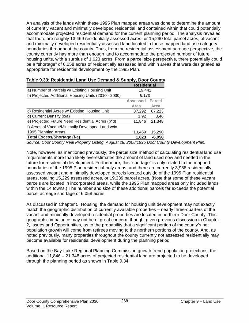
Door County Comprehensive Plan 2030 Chapter 9 – Land Use Volume II, Resource Report
268
An analysis of the lands within these 1995 Plan mapped areas was done to determine the amount of currently vacant and minimally developed residential land contained within that could potentially accommodate projected residential demand for the current planning period. The analysis revealed that there are roughly 13,469 residentially assessed acres, or 15,290 total parcel acres, of vacant and minimally developed residentially assessed land located in these mapped land use category boundaries throughout the county. Thus, from the residential assessment acreage perspective, the county currently has more than enough land to accommodate the projected number of future housing units, with a surplus of 1,623 acres. From a parcel size perspective, there potentially could be a “shortage” of 6,058 acres of residentially assessed land within areas that were designated as appropriate for residential development by the 1995 Plan. Table 9.33: Residential Land Use Demand & Supply, Door County
a) Number of Parcels w/ Existing Housing Unitb) Projected Additional Housing Units (2010 - 2030)
Assessed Area
Parcel Area
c) Residential Acres w/ Existing Housing Unit 37,292 67,223d) Current Density (c/a) 1.92 3.46e) Projected Future Need Residential Acres (b*d) 11,846 21,348f) Acres of Vacant/Minimally Developed Land w/in 1995 Planning Areas 13,469 15,290Total Excess/Shortage (f-e) 1,623 -6,058
6,17019,441
Residential
Source: Door County Real Property Listing, August 28, 2008;1995 Door County Development Plan. Note, however, as mentioned previously, the parcel size method of calculating residential land use requirements more than likely overestimates the amount of land used now and needed in the future for residential development. Furthermore, this “shortage” is only related to the mapped boundaries of the 1995 Plan residential-only areas, and there are currently 3,988 residentially assessed vacant and minimally developed parcels located outside of the 1995 Plan residential areas, totaling 15,229 assessed acres, or 19,339 parcel acres. (Note that some of these vacant parcels are located in incorporated areas, while the 1995 Plan mapped areas only included lands within the 14 towns.) The number and size of these additional parcels far exceeds the potential parcel acreage shortage of 6,058 acres. As discussed in Chapter 5, Housing, the demand for housing unit development may not exactly match the geographic distribution of currently available properties – nearly three-quarters of the vacant and minimally developed residential properties are located in northern Door County. This geographic imbalance may not be of great concern, though, given previous discussion in Chapter 2, Issues and Opportunities, as to the probability that a significant portion of the county’s net population growth will come from retirees moving to the northern portions of the county. And, as noted previously, many properties throughout the county currently not assessed residentially may become available for residential development during the planning period. Based on the Bay-Lake Regional Planning Commission growth trend population projections, the additional 11,846 – 21,348 acres of projected residential land are projected to be developed through the planning period as shown in Table 9.34.
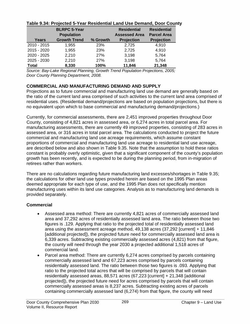
Door County Comprehensive Plan 2030 Chapter 9 – Land Use Volume II, Resource Report
269
Table 9.34: Projected 5-Year Residential Land Use Demand, Door County
Years
BLRPC 5-Year Population
Growth Trend % Growth
Residential Assessed Area
Projection
Residential Parcel Area Projection
2010 - 2015 1,955 23% 2,725 4,9102015 - 2020 1,955 23% 2,725 4,9102020 - 2025 2,210 27% 3,198 5,7642025 - 2030 2,210 27% 3,198 5,764Total 8,330 100% 11,846 21,348 Source: Bay-Lake Regional Planning, Growth Trend Population Projections, 2005; Door County Planning Department, 2008. COMMERCIAL AND MANUFACTURING DEMAND AND SUPPLY Projections as to future commercial and manufacturing land use demand are generally based on the ratio of the current land area comprised of such activities to the current land area comprised of residential uses. (Residential demand/projections are based on population projections, but there is no equivalent upon which to base commercial and manufacturing demand/projections.) Currently, for commercial assessments, there are 2,451 improved properties throughout Door County, consisting of 4,821 acres in assessed area, or 6,274 acres in total parcel area. For manufacturing assessments, there are currently 49 improved properties, consisting of 283 acres in assessed area, or 316 acres in total parcel area. The calculations conducted to project the future commercial and manufacturing land use acreage requirements, which assume constant proportions of commercial and manufacturing land use acreage to residential land use acreage, are described below and also shown in Table 9.35. Note that the assumption to hold these ratios constant is probably overly optimistic, given that a significant component of the county’s population growth has been recently, and is expected to be during the planning period, from in-migration of retirees rather than workers. There are no calculations regarding future manufacturing land excesses/shortages in Table 9.35; the calculations for other land use types provided herein are based on the 1995 Plan areas deemed appropriate for each type of use, and the 1995 Plan does not specifically mention manufacturing uses within its land use categories. Analysis as to manufacturing land demands is provided separately. Commercial
• Assessed area method: There are currently 4,821 acres of commercially assessed land area and 37,292 acres of residentially assessed land area. The ratio between those two figures is .129. Applying that ratio to the projected total of residentially assessed land area using the assessment acreage method, 49,138 acres (37,292 [current] + 11,846 [additional projected]), the projected future need for commercially assessed land area is 6,339 acres. Subtracting existing commercially assessed acres (4,821) from that figure, the county will need through the year 2030 a projected additional 1,518 acres of commercial land.
• Parcel area method: There are currently 6,274 acres comprised by parcels containing commercially assessed land and 67,223 acres comprised by parcels containing residentially assessed land. The ratio between those two figures is .093. Applying that ratio to the projected total acres that will be comprised by parcels that will contain residentially assessed areas, 88,571 acres (67,223 [current] + 21,348 [additional projected]), the projected future need for acres comprised by parcels that will contain commercially assessed areas is 8,237 acres. Subtracting existing acres of parcels containing commercially assessed land (6,274) from that figure, the county will need
Door County Comprehensive Plan 2030 Chapter 9 – Land Use Volume II, Resource Report
270
through the year 2030 a projected additional 1,963 acres comprised by parcels containing commercially assessed areas.
Manufacturing
• Assessed area method: There are currently 283 acres of land area assessed as manufacturing and 37,292 acres of land area assessed residentially. The ratio between those two figures is .008. Applying that ratio to the projected total of residentially assessed land area using the assessment acreage method, 49,138 acres (37,292 [current] + 11,846 [additional projected]), the projected future need for land area assessed as manufacturing is 393 acres. Subtracting existing areas assessed as manufacturing (283) from that figure, the county will need through the year 2030 a projected additional 110 acres of manufacturing land.
• Parcel area method: There are currently 316 acres comprised by parcels containing land assessed as manufacturing and 67,223 acres comprised by parcels containing residentially assessed land. The ratio between those two figures is .005. Applying that ratio to the projected total acres that will be comprised by parcels that will contain residentially assessed areas, 88,571 acres (67,223 [current] + 21,348 [additional projected]), the projected future need for acres comprised by parcels that will contain land assessed as manufacturing is 443 acres. Subtracting existing acres of parcels containing land assessed as manufacturing (316) from that figure, the county will need through the year 2030 a projected additional 127 acres comprised by parcels containing areas assessed as manufacturing.
As with residential land uses, it is appropriate to look at potential developable areas for commercial uses through the framework of the 1995 Door County Development Plan. The 1995 Plan mapped general areas where commercial growth should ideally occur and gave the descriptions below for each area. As noted above, these commercial areas do not specifically mention manufacturing uses, so these areas were used only for the commercial excess/shortage calculations found in Table 9.34.
• “Development Core Areas - These areas consist of existing built-up communities and their planned expansion areas. These communities already contain a fairly dense mixture of commercial, residential, and institutional uses. In many cases public sewer already exists. In general, future high density development, whether commercial, residential, or mixed-use, should be directed to these areas.”
• “Crossroads Communities - Several small communities are scattered throughout the county. Most of these areas have historically been minor development nodes and are usually situated at a major crossroads. Public sewer is not expected to extend to any of these crossroads communities.”
• “Business Development Areas - In addition to the Development Core Areas, several other prospective growth nodes are mapped as business development areas. These areas range from existing commercial corridors such as the Egg Harbor Road/Old Highway Road corridor in Sevastopol to planned business and light industrial parks such as along Highway F in Baileys Harbor. Some form of growth is encouraged in all of these areas, but it should be geared towards the type of development appropriate for each individual area.”
An analysis of the lands within these 1995 Plan mapped commercial areas was done to determine the amount of vacant commercial land contained within that could potentially accommodate projected commercial demand through for the current planning period. The analysis revealed that there are 61 parcels of vacant commercially assessed land located in these mapped land use
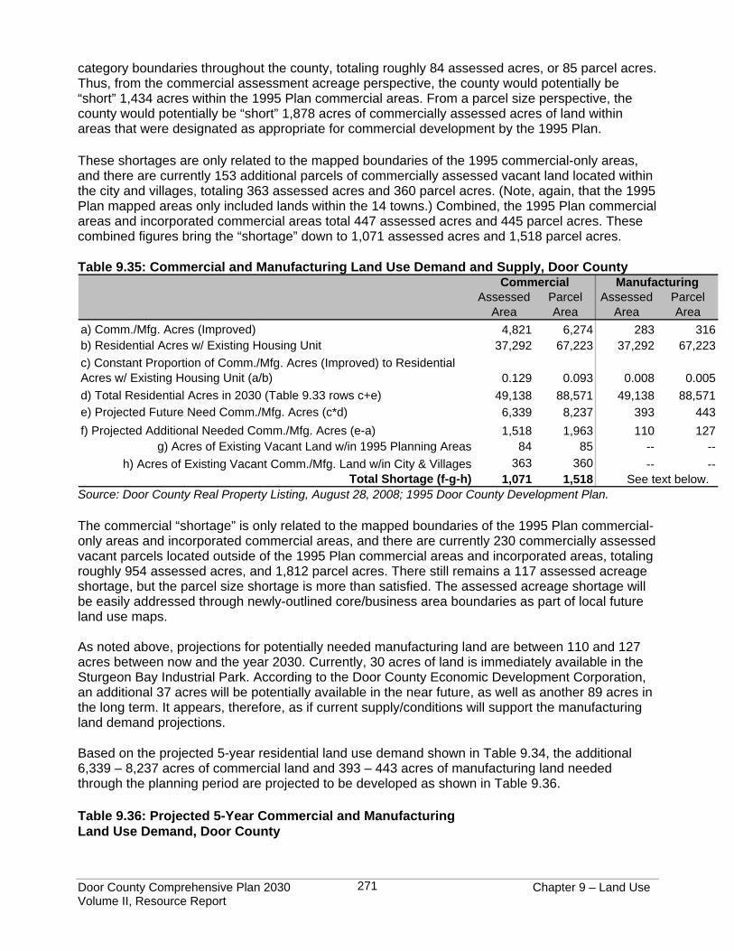
Door County Comprehensive Plan 2030 Chapter 9 – Land Use Volume II, Resource Report
271
category boundaries throughout the county, totaling roughly 84 assessed acres, or 85 parcel acres. Thus, from the commercial assessment acreage perspective, the county would potentially be “short” 1,434 acres within the 1995 Plan commercial areas. From a parcel size perspective, the county would potentially be “short” 1,878 acres of commercially assessed acres of land within areas that were designated as appropriate for commercial development by the 1995 Plan. These shortages are only related to the mapped boundaries of the 1995 commercial-only areas, and there are currently 153 additional parcels of commercially assessed vacant land located within the city and villages, totaling 363 assessed acres and 360 parcel acres. (Note, again, that the 1995 Plan mapped areas only included lands within the 14 towns.) Combined, the 1995 Plan commercial areas and incorporated commercial areas total 447 assessed acres and 445 parcel acres. These combined figures bring the “shortage” down to 1,071 assessed acres and 1,518 parcel acres. Table 9.35: Commercial and Manufacturing Land Use Demand and Supply, Door County
Assessed Area
Parcel Area
Assessed Area
Parcel Area
a) Comm./Mfg. Acres (Improved) 4,821 6,274 283 316b) Residential Acres w/ Existing Housing Unit 37,292 67,223 37,292 67,223c) Constant Proportion of Comm./Mfg. Acres (Improved) to Residential Acres w/ Existing Housing Unit (a/b) 0.129 0.093 0.008 0.005d) Total Residential Acres in 2030 (Table 9.33 rows c+e) 49,138 88,571 49,138 88,571e) Projected Future Need Comm./Mfg. Acres (c*d) 6,339 8,237 393 443f) Projected Additional Needed Comm./Mfg. Acres (e-a) 1,518 1,963 110 127
g) Acres of Existing Vacant Land w/in 1995 Planning Areas 84 85 -- --h) Acres of Existing Vacant Comm./Mfg. Land w/in City & Villages 363 360 -- --
Total Shortage (f-g-h) 1,071 1,518
Commercial Manufacturing
See text below. Source: Door County Real Property Listing, August 28, 2008; 1995 Door County Development Plan. The commercial “shortage” is only related to the mapped boundaries of the 1995 Plan commercial-only areas and incorporated commercial areas, and there are currently 230 commercially assessed vacant parcels located outside of the 1995 Plan commercial areas and incorporated areas, totaling roughly 954 assessed acres, and 1,812 parcel acres. There still remains a 117 assessed acreage shortage, but the parcel size shortage is more than satisfied. The assessed acreage shortage will be easily addressed through newly-outlined core/business area boundaries as part of local future land use maps. As noted above, projections for potentially needed manufacturing land are between 110 and 127 acres between now and the year 2030. Currently, 30 acres of land is immediately available in the Sturgeon Bay Industrial Park. According to the Door County Economic Development Corporation, an additional 37 acres will be potentially available in the near future, as well as another 89 acres in the long term. It appears, therefore, as if current supply/conditions will support the manufacturing land demand projections. Based on the projected 5-year residential land use demand shown in Table 9.34, the additional 6,339 – 8,237 acres of commercial land and 393 – 443 acres of manufacturing land needed through the planning period are projected to be developed as shown in Table 9.36. Table 9.36: Projected 5-Year Commercial and Manufacturing Land Use Demand, Door County
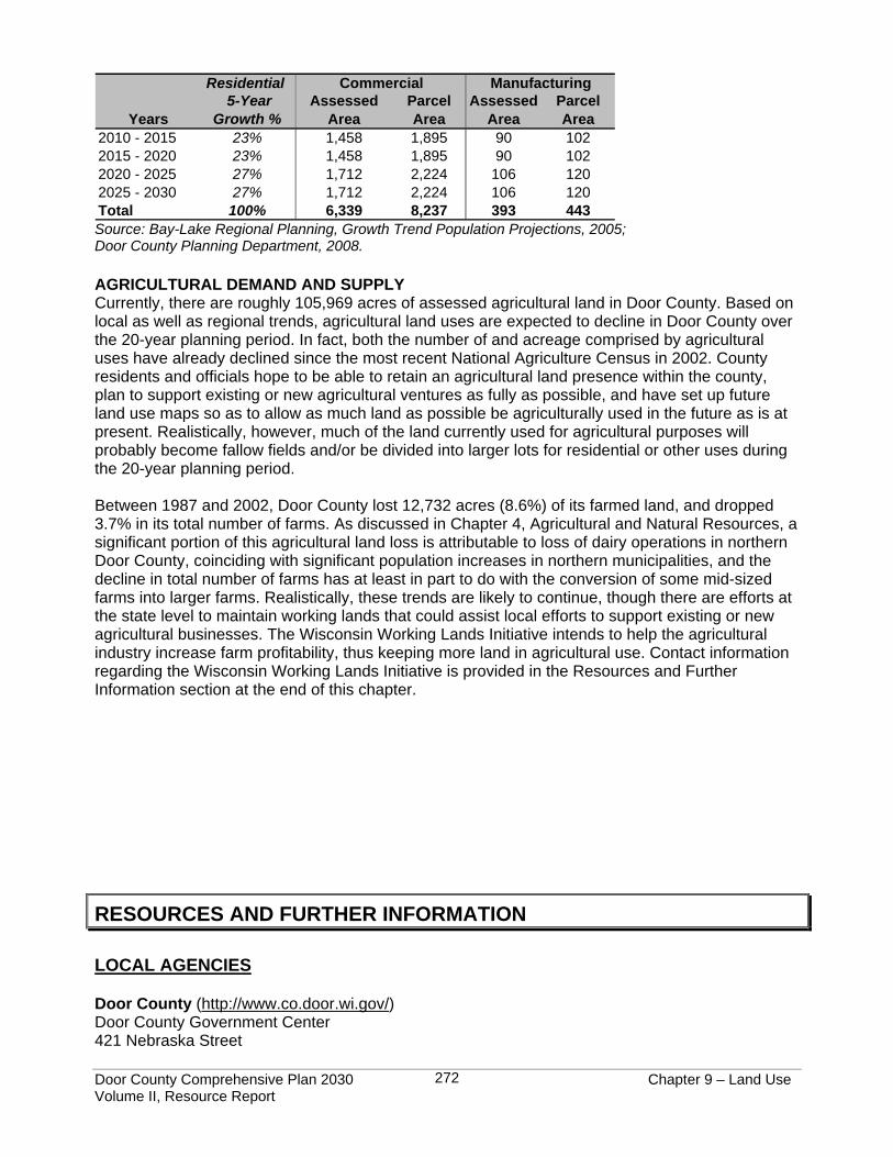
Door County Comprehensive Plan 2030 Chapter 9 – Land Use Volume II, Resource Report
272
Residential
Years 5-Year
Growth % Assessed
Area Parcel Area
Assessed Area
Parcel Area
2010 - 2015 23% 1,458 1,895 90 1022015 - 2020 23% 1,458 1,895 90 1022020 - 2025 27% 1,712 2,224 106 1202025 - 2030 27% 1,712 2,224 106 120Total 100% 6,339 8,237 393 443
Commercial Manufacturing
Source: Bay-Lake Regional Planning, Growth Trend Population Projections, 2005; Door County Planning Department, 2008. AGRICULTURAL DEMAND AND SUPPLY Currently, there are roughly 105,969 acres of assessed agricultural land in Door County. Based on local as well as regional trends, agricultural land uses are expected to decline in Door County over the 20-year planning period. In fact, both the number of and acreage comprised by agricultural uses have already declined since the most recent National Agriculture Census in 2002. County residents and officials hope to be able to retain an agricultural land presence within the county, plan to support existing or new agricultural ventures as fully as possible, and have set up future land use maps so as to allow as much land as possible be agriculturally used in the future as is at present. Realistically, however, much of the land currently used for agricultural purposes will probably become fallow fields and/or be divided into larger lots for residential or other uses during the 20-year planning period. Between 1987 and 2002, Door County lost 12,732 acres (8.6%) of its farmed land, and dropped 3.7% in its total number of farms. As discussed in Chapter 4, Agricultural and Natural Resources, a significant portion of this agricultural land loss is attributable to loss of dairy operations in northern Door County, coinciding with significant population increases in northern municipalities, and the decline in total number of farms has at least in part to do with the conversion of some mid-sized farms into larger farms. Realistically, these trends are likely to continue, though there are efforts at the state level to maintain working lands that could assist local efforts to support existing or new agricultural businesses. The Wisconsin Working Lands Initiative intends to help the agricultural industry increase farm profitability, thus keeping more land in agricultural use. Contact information regarding the Wisconsin Working Lands Initiative is provided in the Resources and Further Information section at the end of this chapter.
RESOURCES AND FURTHER INFORMATION LOCAL AGENCIES Door County (http://www.co.door.wi.gov/) Door County Government Center 421 Nebraska Street

Door County Comprehensive Plan 2030 Chapter 9 – Land Use Volume II, Resource Report
273
Sturgeon Bay, WI 54235 Department Phone Numbers and Web sites (if applicable): Information Systems (920) 746-2498 http://map.co.door.wi.us/ Parks (920) 746-9959 http://map.co.door.wi.us/parks/ Planning (920) 746-2323 http://map.co.door.wi.us/planning/ Real Property Listing Office (920) 746-2287 Soil and Water Conservation (920) 746-2214 http://map.co.door.wi.us/swcd/ Sanitarian (920) 746-2308 Treasurer (920) 746-2525 University of Wisconsin - Extension (920) 746-2260 http://www.uwex.edu/ces/cty/door/ Door County Board of REALTORS® (DCBR) (http://www.dcbr.org/) 325 North Third Avenue Sturgeon Bay, WI 54235 Phone: (920) 743-9651 The DCBR is the local professional association for real estate agents working in Door and Kewaunee Counties. The DCBR collects a variety of information related to housing sales and listings. Northeast Wisconsin Multiple Listing Service (MLS) (http://www.ranw.org/default.asp) 2181 South Oneida Street Green Bay, WI 54304 Phone: (920) 494-8010 The Northeast Wisconsin MLS serves multiple counties, including Door County. Door County Cooperative Agronomist (http://www.doorcountycoop.com/) 7460 Highway 42/57 Sturgeon Bay, WI 54235 Phone: (920) 743-7304 REGIONAL AND STATE AGENCIES Bay-Lake Regional Planning Commission (BLRPC) (http://www.baylakerpc.org/) 441 South Jackson Street Green Bay, WI 54301 Phone: (920) 448-2820 BLRPC provides planning services on area-wide issues, represents local interests on state and federal planning program activities, and provides local planning assistance to communities in the Bay-Lake Region. A variety of regional and local planning documents can be found at http://www.baylakerpc.org/Documents/index.html, including the Wisconsin Standard Land Use Classification System and the Bay-Lake Regional Comprehensive Plan. Wisconsin Department of Administration - Division of Intergovernmental Relations (http://www.doa.state.wi.us/) 101 East Wilson Street Madison, Wisconsin 53703 The Division of Intergovernmental Relations supports counties, municipalities, citizens and businesses by providing support services in land use planning, land information and records modernization, municipal boundary review, plat review, demography and coastal management programs.
Door County Comprehensive Plan 2030 Chapter 9 – Land Use Volume II, Resource Report
274
Wisconsin Department of Natural Resources (DNR) (http://dnr.wi.gov/) Sturgeon Bay Office 110 South Neenah Avenue Sturgeon Bay, WI 54235 Phone: (920) 746-2860 The DNR is dedicated to the preservation, protection, effective management, and maintenance of Wisconsin's natural resources. It is responsible for implementing the laws of the state and, where applicable, the laws of the federal government that protect and enhance the natural resources of our state. DNR information on wetlands: http://dnr.wi.gov/wetlands/
• Door County Comprehensive Forestry Plan: http://www.wisaf.org/images/Door_County_Comprehensive_Forestry_Plan.pdf
• Wisconsin Working Lands Initiative: http://www.datcp.state.wi.us/workinglands/ Wisconsin Department of Revenue (www.dor.state.wi.us) Green Bay Office 200 North Jefferson Street, Room 526 54301-5158 Phone: (920) 448-5179 Wisconsin Department of Commerce - Division of Safety and Buildings (http://www.commerce.state.wi.us/SB/) 201 West Washington Avenue Madison WI 53703 Phone: (608) 266-3151


