210 Surface Water Surface Water 9 9 What You’ll Learn • What landscape features on Earth are formed and changed by surface water. • How surface water moves materials and impacts humans. Why It’s Important Landscape features formed by surface water are among the most numerous and visible features on Earth. Running water has the greatest impact on humans because we depend on streams for drinking-water supplies and irrigation. Humans also experience the nega- tive effects of floods. To find out more about surface water, visit the Earth Science Web Site at ear thgeu.com
Transcript
210
SurfaceWaterSurfaceWater
99What You’ll Learn• What landscape features
on Earth are formed andchanged by surfacewater.
• How surface watermoves materials andimpacts humans.
Why It’s ImportantLandscape featuresformed by surface waterare among the mostnumerous and visible features on Earth.Running water has thegreatest impact onhumans because wedepend on streams fordrinking-water suppliesand irrigation. Humansalso experience the nega-tive effects of floods.
To find out more about surface water, visit theEarth Science Web Site at earthgeu.com
When water seeps into the ground,it moves at various rates through thedifferent materials that make upEarth’s surface. These Earth materialsare comprised of different particlesizes. In this activity, you will inves-tigate the movement of water as itseeps through two different kinds ofEarth materials.
1. Place a small window screen oneach of two clear plastic shoeboxes.
2. Place an 8 cm � 16 cm clump ofgrass or sod on one screen.
3. Place an 8 cm � 16 cm clump of
barren soil on the other screen.
4. Lightly sprinkle 500 mL of wateron each clump.
CAUTION: Always wear anapron in the lab.
Observe In your sciencejournal, describe what happensto the water after five minutes.Measure how much water passesthrough each clump and collects in the plastic shoe box. Explainany differences in the amount of water collected in each plastic shoe box.
Modeling WaterMovement
Discovery LabDiscovery Lab
OBJECTIVES
• Explain how surfacewater can move weath-ered materials.
• Explain how a streamcarries its load.
• Describe how a flood-plain develops.
VOCABULARY
runoff bed loadwatershed dischargedivide floodsolution floodplainsuspension
Earth’s water supply is recycled in a continuous process called thewater cycle. Water molecules move continuously through the watercycle following many pathways: they evaporate from a body of wateror the surface of Earth, condense into cloud droplets, fall as precipi-tation back to Earth’s surface, and soak into the ground. As part ofa continuous cycle, the water eventually evaporates back into theatmosphere, again forms clouds, again falls as precipitation, and soon. Understanding the mechanics of the water cycle helps to explainthe reasons for variations in the amount of water that is availablethroughout the world.
Often, a water molecule’s pathway involves time spent within a liv-ing organism or as part of a snowfield, glacier, lake, or ocean.Although water molecules may follow a number of different path-ways, the overall process is one of repeated evaporation and conden-sation powered by the Sun’s energy. What happens once water reachesEarth’s surface? Does all the water sink into the ground or evaporate?
Surface Water Movement9.19.1
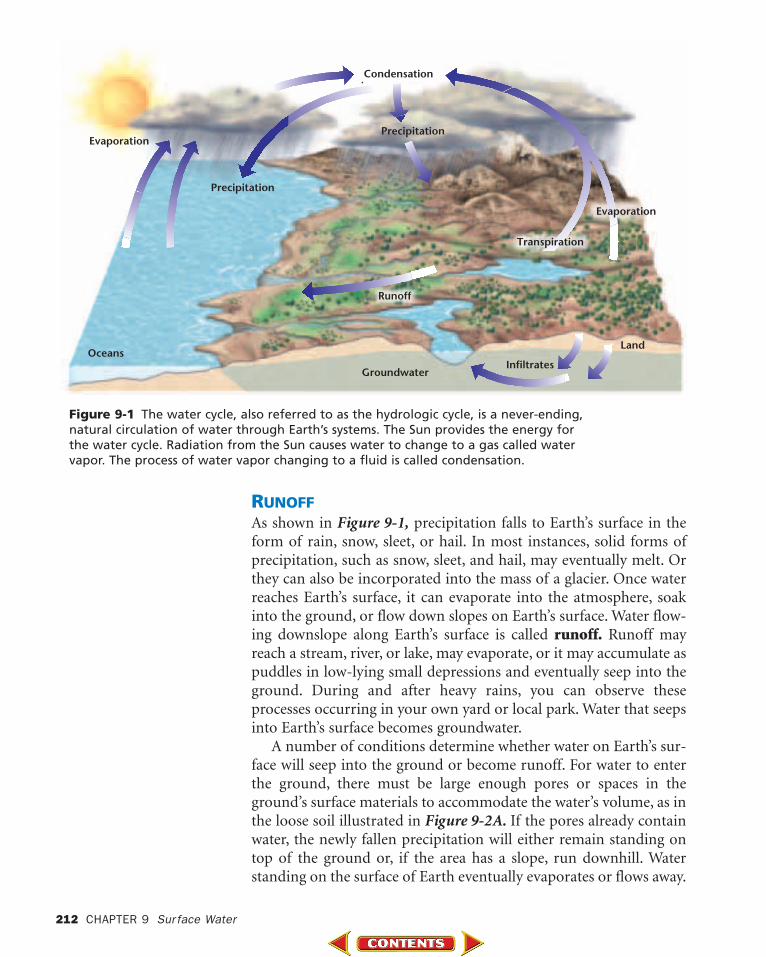
Figure 9-1 The water cycle, also referred to as the hydrologic cycle, is a never-ending,natural circulation of water through Earth’s systems. The Sun provides the energy forthe water cycle. Radiation from the Sun causes water to change to a gas called watervapor. The process of water vapor changing to a fluid is called condensation.
RUNOFFAs shown in Figure 9-1, precipitation falls to Earth’s surface in theform of rain, snow, sleet, or hail. In most instances, solid forms ofprecipitation, such as snow, sleet, and hail, may eventually melt. Orthey can also be incorporated into the mass of a glacier. Once waterreaches Earth’s surface, it can evaporate into the atmosphere, soakinto the ground, or flow down slopes on Earth’s surface. Water flow-ing downslope along Earth’s surface is called runoff. Runoff mayreach a stream, river, or lake, may evaporate, or it may accumulate aspuddles in low-lying small depressions and eventually seep into theground. During and after heavy rains, you can observe theseprocesses occurring in your own yard or local park. Water that seepsinto Earth’s surface becomes groundwater.
A number of conditions determine whether water on Earth’s sur-face will seep into the ground or become runoff. For water to enterthe ground, there must be large enough pores or spaces in theground’s surface materials to accommodate the water’s volume, as inthe loose soil illustrated in Figure 9-2A. If the pores already containwater, the newly fallen precipitation will either remain standing ontop of the ground or, if the area has a slope, run downhill. Waterstanding on the surface of Earth eventually evaporates or flows away.
212 CHAPTER 9 Sur face Water
Land
Evaporation
Evaporation
Transpiration
Condensation
Precipitation
Precipitation
Oceans
Runoff
InfiltratesGroundwater
Vegetation Soils that contain grasses or other vegetation allowmore water to enter the ground than do soils with no vegetation.Precipitation falling on vegetation slowly flows down leaves andbranches, and it eventually drops gently to the ground. In contrast,precipitation falls with far more force onto barren land. In suchareas, soil particles clump together and form dense aggregates withfew pores or spaces between them. The force of falling rain may thenpush the soil clumps together, thereby closing pores and allowing lesswater to enter, as illustrated in Figure 9-2B. This is why gardeners donot pack the soil around their plants. Compacting the soil reducesthe spaces between the particles that are available for water to seepin, thus reducing the amount of water that is available to the plants’roots.
Rate of Precipitation Light, gentle precipitation infiltrates thedry ground. However, the rate of precipitation may temporarilyexceed the rate of infiltration. For example, during heavy precipita-tion, water falls too quickly to soak into the ground and becomesrunoff. Thus, a gentle, long-lasting rainfall is more beneficial toplants and causes less erosion by runoff than a torrential downpour.If you have a garden, remember that more water will enter theground if you water your plants slowly and gently.
Soil Composition The physical and chemical composition ofsoil also affects its water-holding capacity. Soil consists of decayedorganic matter, called humus, and minerals. Humus creates pores inthe soil, thereby increasing a soil’s ability to retain water. The min-erals in soil have different particle sizes, which are classified as sand,silt, or clay. As you learned in Chapter 7, the percentages of particlesof each size vary from soil to soil. Soil with a high percentage ofcoarse particles, such as sand, has relatively large pores between itsparticles that allow water to enter and pass through the soil quickly.In contrast, soil with a high percentage of fine particles, such as clay,clumps together and has few or no spaces between the particles.
9.1 Sur face Water Movement 213
Figure 9-2 Soil that hasopen surface pores orspaces between particlesallows water to infiltrate(A). Soil that has few orno pores or spaces canrestrict water’s ability toseep in (B).
A B
Steep slope–rapid runoff
Little slope–little runoff
Slope
Figure 9-4 Numerous trib-utaries flow into severalstream systems that draininto the Salton Sea inCalifornia.
214 CHAPTER 9 Sur face Water
Such small pores restrict both the amount of water that can enterthe ground and the ease of movement of water through the soil.
Slope As you have learned, the slope of a land area plays a large rolein determining the ability of water to enter the ground, as shown inFigure 9-3. Water from precipitation falling on slopes flows to areasof lower elevation. The steeper the slope, the faster the water flows.There is also greater potential for erosion on steep slopes. In areaswith steep slopes, little water seeps into the ground before it runs off.
STREAM SYSTEMSPrecipitation that does not enter the ground usually runs off the sur-face quickly. Some surface water flows in thin sheets and eventuallycollects in small channels. As the amount of runoff increases, thechannels widen, deepen, and become longer. Although it is commonfor these small channels to dry up shortly after precipitation stops, thechannels again fill with water each time it rains and become largerand longer. If a sufficient supply of water develops, the water beginsto flow more permanently in a channel and can become a stream.
All streams flow downslope in a watery path to lower elevations.However, the path of a stream can vary considerably, depending onthe slope of the land and the type of material through which thestream flows. Some streams flow into lakes, while others flow directlyinto the ocean. Still others, called tributaries, flow into other streams,as shown in Figure 9-4. Each tributary increases the size of thestream it is joining and adds water to it. A large stream is called ariver, and all its tributaries make up a stream, or river system. Smallstreams are called brooks and creeks. If there are any brooks orstreams near your home, can you locate where they feed into otherstreams or lakes?
Figure 9-3 The angle of a slope is one variable thatinfluences the movement ofsurface water on a slope.
To learn more about rivers, go to theNational GeographicExpedition on page 870.
WATERSHEDS AND DIVIDESAll of the land area whose water drains into a stream system is calledthe system’s watershed, or drainage basin. Watersheds can be rela-tively small or extremely large in area. A divide is a high land areathat separates one watershed from another. Each tributary in astream system has its own watershed and divides, but they are all partof the larger stream system to which the tributary belongs. Thewatershed of the Mississippi River, shown in Figure 9-5, is the largestin North America.
STREAM LOADAll the materials that the water in a stream carries is known as thestream’s load. The living components of water include microscopiclife-forms as well as larger plants and animals. The nonliving com-ponents of surface water include sediments, dissolved solids, and dis-solved atmospheric gases, such as oxygen. There are three ways inwhich a stream carries its load.
Solution Material is carried in solution after it becomes dissolvedin a stream’s water. How much of a stream’s load is carried in solu-tion depends on the material through which the stream’s water haspassed. When water runs through or over rocks containing soluble
Figure 9-5 The watershedof the Mississippi Riverincludes a large stream system. How many majorrivers are part of theMississippi watershed?
9.1 Sur face Water Movement 215
500 kmMississippiDelta0
Red River
White R.
Cumberland
R.
Tennes
see
R.
Illin
ois R
.
Wab
as
hR.
Arkansas River
Ohio Rive
r
Missouri
River
Mississippi R.
Watershed of the Mississippi River
minerals, it dissolves small amounts of the minerals and carries themaway in solution. Water may readily dissolve calcium carbonate fromlimestone and marble, for example. Streams also commonly carrysoluble magnesium compounds. Groundwater adds most of the dis-solved load to stream water, while runoff adds only a very smallamount.
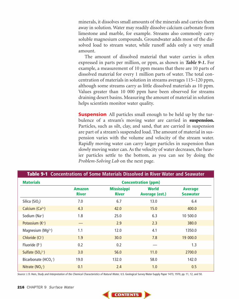
The amount of dissolved material that water carries is oftenexpressed in parts per million, or ppm, as shown in Table 9-1. Forexample, a measurement of 10 ppm means that there are 10 parts ofdissolved material for every 1 million parts of water. The total con-centration of materials in solution in streams averages 115–120 ppm,although some streams carry as little dissolved materials as 10 ppm.Values greater than 10 000 ppm have been observed for streamsdraining desert basins. Measuring the amount of material in solutionhelps scientists monitor water quality.
Suspension All particles small enough to be held up by the tur-bulence of a stream’s moving water are carried in suspension.Particles, such as silt, clay, and sand, that are carried in suspensionare part of a stream’s suspended load. The amount of material in sus-pension varies with the volume and velocity of the stream water.Rapidly moving water can carry larger particles in suspension thanslowly moving water can. As the velocity of water decreases, the heav-ier particles settle to the bottom, as you can see by doing theProblem-Solving Lab on the next page.
216 CHAPTER 9 Sur face Water
Table 9-1 Concentrations of Some Materials Dissolved in River Water and Seawater
Materials Concentration (ppm)
Amazon Mississippi World AverageRiver River Average (est.) Seawater
Silica (SiO2) 7.0 6.7 13.0 6.4
Calcium (Ca2+) 4.3 42.0 15.0 400.0
Sodium (Na+) 1.8 25.0 6.3 10 500.0
Potassium (K+) — 2.9 2.3 380.0
Magnesium (Mg2+) 1.1 12.0 4.1 1350.0
Chloride (CI–) 1.9 30.0 7.8 19 000.0
Fluoride (F–) 0.2 0.2 — 1.3
Sulfate (SO42–) 3.0 56.0 11.0 2700.0
Bicarbonate (HCO3–) 19.0 132.0 58.0 142.0
Nitrate (NO3–) 0.1 2.4 1.0 0.5
Source: J. D. Hem, Study and Interpretation of the Chemical Characteristics of Natural Water, U.S. Geological Survey Water-Supply Paper 1473, 1970, pp. 11, 12, and 50.
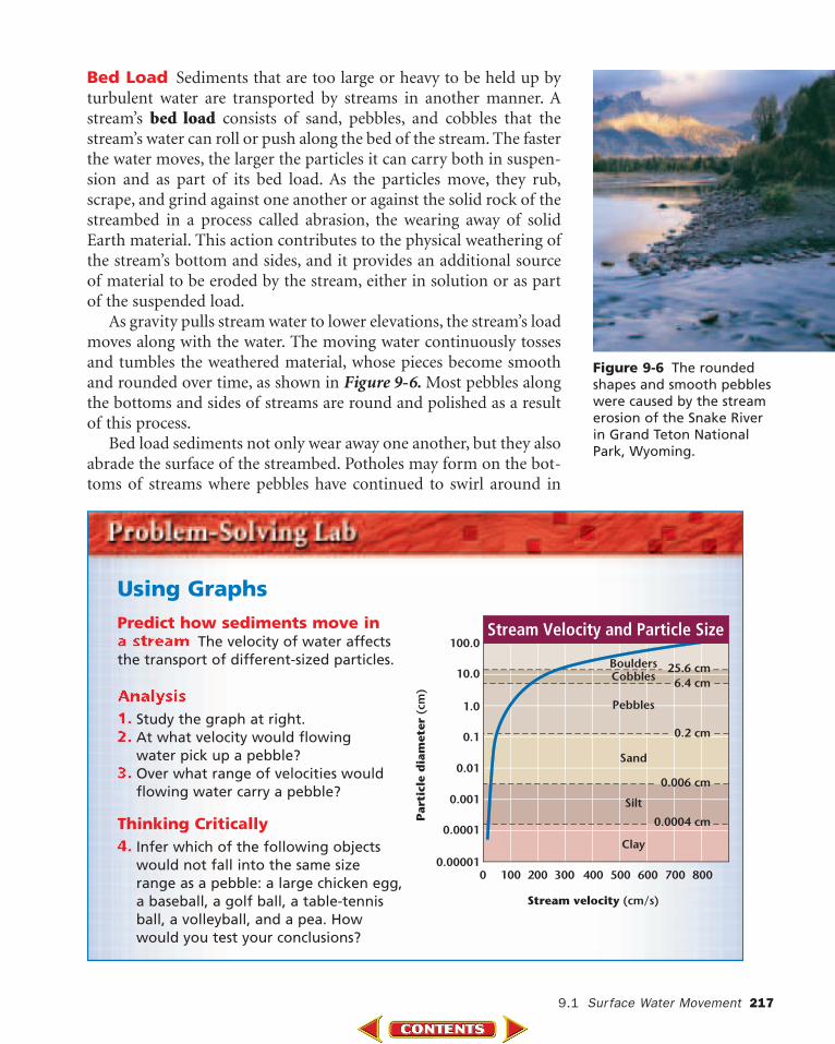
Bed Load Sediments that are too large or heavy to be held up byturbulent water are transported by streams in another manner. Astream’s bed load consists of sand, pebbles, and cobbles that thestream’s water can roll or push along the bed of the stream. The fasterthe water moves, the larger the particles it can carry both in suspen-sion and as part of its bed load. As the particles move, they rub,scrape, and grind against one another or against the solid rock of thestreambed in a process called abrasion, the wearing away of solidEarth material. This action contributes to the physical weathering ofthe stream’s bottom and sides, and it provides an additional sourceof material to be eroded by the stream, either in solution or as partof the suspended load.
As gravity pulls stream water to lower elevations, the stream’s loadmoves along with the water. The moving water continuously tossesand tumbles the weathered material, whose pieces become smoothand rounded over time, as shown in Figure 9-6. Most pebbles alongthe bottoms and sides of streams are round and polished as a resultof this process.
Bed load sediments not only wear away one another, but they alsoabrade the surface of the streambed. Potholes may form on the bot-toms of streams where pebbles have continued to swirl around in
9.1 Sur face Water Movement 217
Using Graphs
100.0
10.0
1.0
0.1
0.01
Par
ticl
e d
iam
eter
(cm
)
0.001
0.00010.0004 cm
0.006 cm
Silt
Sand
Pebbles
CobblesBoulders
Clay
0.2 cm
6.4 cm25.6 cm
0.00001100 200 300 400
Stream velocity (cm/s)
500 600 700 8000
Stream Velocity and Particle Size
Figure 9-6 The roundedshapes and smooth pebbleswere caused by the streamerosion of the Snake Riverin Grand Teton NationalPark, Wyoming.
Predict how sediments move in a stream The velocity of water affectsthe transport of different-sized particles.
Analysis1. Study the graph at right.2. At what velocity would flowing
water pick up a pebble?3. Over what range of velocities would
flowing water carry a pebble?
Thinking Critically4. Infer which of the following objects
would not fall into the same sizerange as a pebble: a large chicken egg,a baseball, a golf ball, a table-tennisball, a volleyball, and a pea. Howwould you test your conclusions?
one area and have slowly worn holes intosolid rock. For example, potholes morethan 3 m deep have formed near LittleFalls, New York, in the Mohawk RiverValley. Potholes can be found even instreambeds composed of very hard,exposed bedrock. The huge depressionsin the streambed of the Wisconsin River,shown in Figure 9-7, were scoured out ofgranite. Large streambed potholes dra-matically illustrate the powerful abrasiveaction caused by a stream’s bed load.
STREAM VELOCITY AND CARRYING CAPACITYThe ability of a stream to transport material, referred to as its carry-ing capacity, depends on both the velocity and the amount of watermoving in the stream. Study Figure 9-8 as you read. The channel’sslope, depth, and width all affect the speed and direction in whichwater moves within it. A stream’s water moves more quickly wherethere is less friction; consequently, smooth-sided channels with greatslope and depth allow water to move most rapidly. The total volumeof moving water also affects a stream’s carrying capacity. Dischargeis the measure of the volume of stream water that flows over a par-ticular location within a given period of time. Discharge is com-monly expressed in cubic meters per second (m3/s). The followingformula is used to calculate the discharge of a stream:
The largest river in North America, the Mississippi, has a hugeaverage discharge of 173 600 m3/s. However, the Amazon River, thelargest in the world, has an incredible discharge ten times thatamount. The discharge from the Amazon River over a 24-hourperiod would supply New York City’s water needs for nine years!
218 CHAPTER 9 Sur face Water
Figure 9-7 The potholes in thisWisconsin River streambed werescoured out by the abrasive action ofthe stream’s bed load. The river islocated at Grandfather Falls, Wisconsin.
As a stream’s discharge increases, the stream’s carrying capacityincreases as well. The increased discharge results in a stream withgreater carrying capacity as modeled in the GeoLab at the end of thechapter. Both water velocity and volume increase during times ofheavy precipitation, rapid melting of snow, and flooding. In addi-tion to increasing a stream’s carrying capacity, these conditionsheighten a stream’s ability to erode the land over which it passes. Asa result of an increase in erosional power, a streambed can widenand deepen, thereby increasing the stream slope and further addingto the stream’s carrying capacity. As shown in Figure 9-9, the extra-ordinary power of water during such times can be especiallyhazardous for people who do not anticipate the dangersassociated with flooding.
FLOODPLAINSThe amount of water being transported in a particularstream at any given time varies with weather conditions.Sometimes, more water pours into a stream than the banksof the stream channel can hold. A flood occurs when waterspills over the sides of a stream’s banks onto the adjacentland. The broad, flat area that extends out from a stream’sbank and is covered by excess water during times of floodingis known as the stream’s floodplain. Floodwater carriesalong with it a great amount of sediment eroded from Earth’ssurface and the sides of the stream channel. As floodwaterrecedes and its volume and speed decrease, the water dropsits sediment load onto the stream’s floodplain.
9.1 Sur face Water Movement 219
A
B
C
Figure 9-8 Describe thechanges in the downstreamdirection of the stream’schannel as the water flowsfrom section A to section C.
Figure 9-9 Several days ofheavy rains in Buenos Aires,Argentina caused floodwaters to strand traffic inthe city.
Figure 9-10 illustrates a floodplain after a river overflows its channel. Floodplains develop highly fertile soils as more sediment isdeposited with each subsequent flood. These fertile soils have histor-ically enticed farmers to use the land for crop production, even at therisk of losing homes and crops to subsequent flooding.
FLOODSFloods are a natural occurrence. When a stream reaches its floodstage, a flood can occur, as shown in Figure 9-11. Flood stage is thelevel at which a stream overflows its banks and the crest of the streamis the maximum height. Because it takes time for runoff to collect instreams, the water continues to rise and may reach its crest days afterprecipitation ends. The resulting flooding may occur over localized,small areas or across large regions. The flooding of a small area isknown as an upstream flood. Sudden rainstorms that drop largeamounts of rain within a short period of time cause upstream floods,
Figure 9-11 Davenport,Iowa was just one of manyareas that was flooded bythe Mississippi River in 1993.
Topic: FloodsTo find out more aboutfloods and flood preven-tion, visit the Earth ScienceWeb Site at earthgeu.com
Activity: Write a briefreport to compare andcontrast the flooding ofthe Yellow River in China,the Nile River in Egypt, and the Mississippi River in the United States.
as do dam failures. Although they are localized, upstream floods cando a great deal of damage within a very short period of time.
Heavy accumulations of excess water from large regional drainagesystems result in downstream floods. Such floods occur during orafter long-lasting, intense storms or spring thaws of large snowpacks.The tremendous volumes of water involved in a downstream floodcan result in extensive damage. For example, the devastating floodsin 1993 along the Mississippi River, which frequently causes down-stream flooding, left landscape scars that are still visible today.
FLOOD MONITORING AND WARNING SYSTEMSIn an attempt to provide warnings for people at risk, govern-
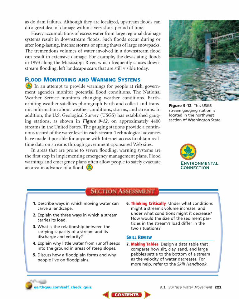
ment agencies monitor potential flood conditions. The NationalWeather Service monitors changing weather conditions. Earth-orbiting weather satellites photograph Earth and collect and trans-mit information about weather conditions, storms, and streams. Inaddition, the U.S. Geological Survey (USGS) has established gaug-ing stations, as shown in Figure 9-12, on approximately 4400streams in the United States. The gauging stations provide a contin-uous record of the water level in each stream. Technological advanceshave made it possible for anyone with Internet access to obtain real-time data on streams through government-sponsored Web sites.
In areas that are prone to severe flooding, warning systems arethe first step in implementing emergency management plans. Floodwarnings and emergency plans often allow people to safely evacuatean area in advance of a flood.
9.1 Sur face Water Movement 221
1. Describe ways in which moving water cancarve a landscape.
2. Explain the three ways in which a streamcarries its load.
3. What is the relationship between the carrying capacity of a stream and its discharge and velocity?
4. Explain why little water from runoff seepsinto the ground in areas of steep slopes.
5. Discuss how a floodplain forms and whypeople live on floodplains.
6. Thinking Critically Under what conditionsmight a stream’s volume increase, andunder what conditions might it decrease?How would the size of the sediment par-ticles in the stream’s load differ in thetwo situations?
SKILL REVIEW
7. Making Tables Design a data table thatcompares how silt, clay, sand, and largepebbles settle to the bottom of a streamas the velocity of water decreases. Formore help, refer to the Skill Handbook.
Figure 9-12 This USGSstream gauging station islocated in the northwestsection of Washington State.
As a stream develops, it changes in shape, width, and size, as well asthe landscapes over which it flows. Stream flow is part of a dynamicsystem that is greatly influenced by the varying environmental con-ditions of the stream’s surroundings.
MOVING WATER CARVES A PATHThe first and foremost condition necessary for stream formation isan adequate supply of water. Precipitation provides the water for thebeginnings of stream formation. In areas where precipitation fallsinfrequently, stream development and flow are also infrequent. Forexample, in some desert areas, where years pass between rainfalls, thestreams that form are short-lived. However, most parts of the tem-perate and tropical regions on Earth experience precipitation on aregular basis.
The region where water first accumulates to supply a stream iscalled the headwaters. It is common for a stream’s headwaters to behigh in the mountains. Falling precipitation accumulates in smallgullies at these higher elevations and forms briskly moving streams.As surface water first begins its flow, its path may not be well defined.In time, however, the moving water carves a narrow pathway into thesediment or rock called a stream channel. The channel widens anddeepens as more and more water accumulates and cuts into Earth’ssurface. As shown in Figure 9-13, the moving water is held within theconfines of the stream channel by the stream banks, the groundbordering the stream on each side. If you have ever fished in astream, you might have sat on a stream bank to do so.
9.29.2 Stream Development
Figure 9-13 The riverbanks confine the water ofthe San Pedro River in the San Pedro Riparian NationalConservation Area inArizona.
OBJECTIVES
• Describe some of thephysical features ofstream development.
• Explain the process ofrejuvenation in streamdevelopment.
VOCABULARY
stream channelstream bankmeanderdeltarejuvenation
222 CHAPTER 9 Sur face Water
9.2 Stream Development 223
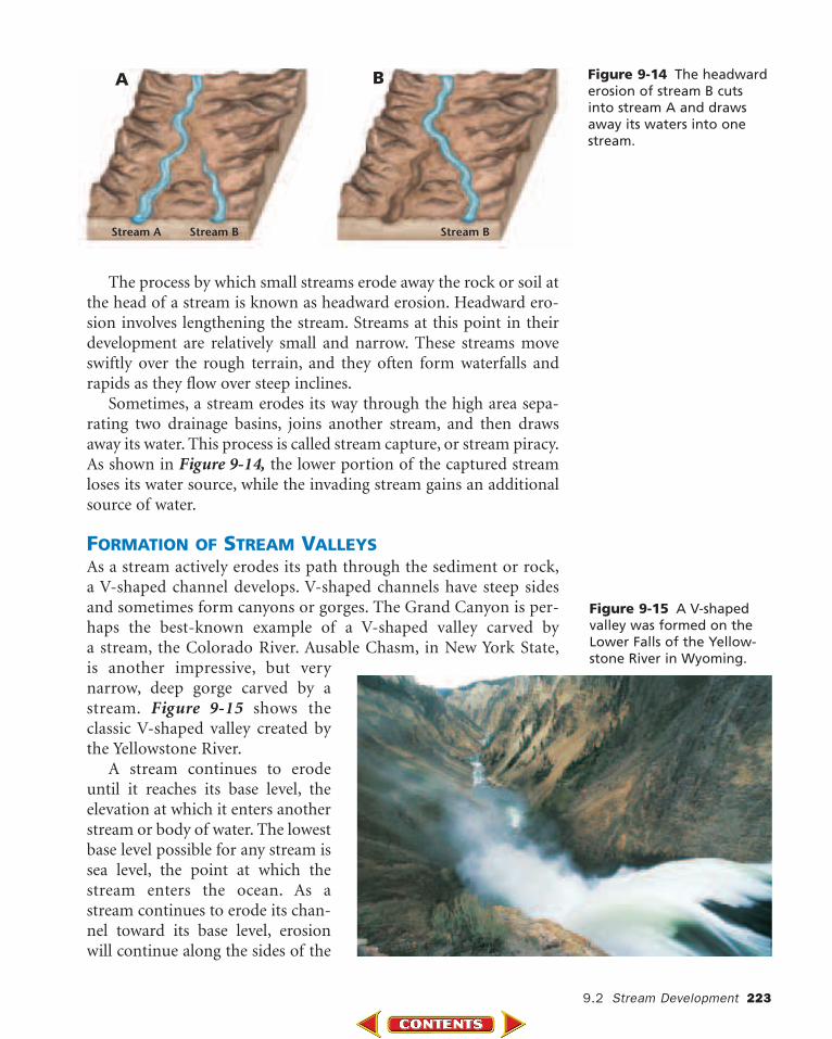
Figure 9-14 The headwarderosion of stream B cutsinto stream A and drawsaway its waters into onestream.
Stream A Stream B Stream B
A B
The process by which small streams erode away the rock or soil atthe head of a stream is known as headward erosion. Headward ero-sion involves lengthening the stream. Streams at this point in theirdevelopment are relatively small and narrow. These streams moveswiftly over the rough terrain, and they often form waterfalls andrapids as they flow over steep inclines.
Sometimes, a stream erodes its way through the high area sepa-rating two drainage basins, joins another stream, and then drawsaway its water. This process is called stream capture, or stream piracy.As shown in Figure 9-14, the lower portion of the captured streamloses its water source, while the invading stream gains an additionalsource of water.
FORMATION OF STREAM VALLEYSAs a stream actively erodes its path through the sediment or rock,a V-shaped channel develops. V-shaped channels have steep sidesand sometimes form canyons or gorges. The Grand Canyon is per-haps the best-known example of a V-shaped valley carved by a stream, the Colorado River. Ausable Chasm, in New York State,is another impressive, but verynarrow, deep gorge carved by astream. Figure 9-15 shows theclassic V-shaped valley created bythe Yellowstone River.
A stream continues to erodeuntil it reaches its base level, theelevation at which it enters anotherstream or body of water. The lowestbase level possible for any stream issea level, the point at which thestream enters the ocean. As astream continues to erode its chan-nel toward its base level, erosionwill continue along the sides of the
Figure 9-15 A V-shapedvalley was formed on theLower Falls of the Yellow-stone River in Wyoming.
V-shaped channel. As shown in Figure 9-16, intime, a V-shaped valley will be eroded into a broader valley that has gentle slopes.
MEANDERING STREAMSAs stream channels develop into broader valleys,the volume of water and sediment that they are ableto carry increases. In addition, a stream’s slope, orgradient, decreases as it nears its base level, and as aresult the channel gets wider. The decrease in gradi-ent causes water to build up within the streamchannel. Sometimes, the water begins to erode thesides of the channel in such a way that the overallpath of the stream starts to bend or wind. As shownin Figure 9-17, a bend or curve in a stream channelcaused by moving water is called a meander.
Water in the straight parts of a stream flows at different velocities,depending on the location of the water in the channel. In a straightlength of a stream, water in the center of the channel is flowing at themaximum velocity. Water along the bottom and sides of the channelflows more slowly because it experiences friction as it moves againstthe land. In contrast, the water moving along the outside of a mean-der curve experiences the greatest rate of flow within the meander.The water that flows along this outside part of the curve continues toerode away the sides of the streambed, thus making the meanderlarger. Along the inside of the meander, the water moves more slowlyand deposition is dominant. These differences in the rate of waterflow within meanders cause the meanders to become more accentu-ated over time. Figure 9-18 illustrates the processes of erosion and
Figure 9-16 The DelawareWater Gap in Pennsylvaniahas been eroded into a wider, broader valley.
224 CHAPTER 9 Sur face Water
Figure 9-17 Several mean-ders are formed in theTundra River in Yukon,Canada.
deposition along a meander, and Figure 9-19 shows the points ofmaximum water velocity within a meander and within a straightpart of a stream. Stream meanders continue to develop and becomelarger and wider over time. After some degree of winding, however,it is common for a stream to cut off a meander and once again flowalong a straighter path. The stream then deposits material along theadjoining meander and eventually blocks off its water supply, asshown in Figure 9-20. The blocked-off meander becomes an oxbowlake, which eventually dries up.
As a stream approaches a larger body of water or its ultimate endpoint, the ocean, the streambed’s gradient flattens out and its chan-nel becomes very wide. The area of the stream that leads into theocean or another large body of water is called the mouth. Themouth of the Mississippi River is extremely wide.
Maximumvelocity
Maximumvelocity
Depositionof point bar
Erosionof cutbank
9.2 Stream Development 225
Figure 9-19 The maximumvelocity of water in a stream will change itsdirection as the streammeanders.
Figure 9-20 The Devil’s Elbow is an oxbow lake along the CongareeRiver in Congaree Swamp National Monument in South Carolina.
Figure 9-18 The high velocity ofwater in a meandering stream erodesone side of the stream’s bank.Deposition occurs when the velocity of the water in a meandering streamslows down.
DEPOSITION OF SEDIMENTStreams that lose velocity also lose theirability to carry sediment. A stream’s veloc-ity lessens and its sediment load dropswhen its gradient abruptly decreases. Indry regions, where mountain streams com-monly flow down narrow valleys ontobroad, flat, valley floors, a stream’s gradientmay suddenly decrease causing the streamto drop its sediment as a fan-shapeddeposit called an alluvial fan. Alluvial fans
are sloping depositional features formed at the bases of slopes andcomposed mostly of sand and gravel. They are found worldwide butare most common in dry, mountainous regions such as Death Valley,California, shown in Figure 9-21.
Streams also lose velocity and the ability to carry sediment whenthey join larger bodies of quiet water. The triangular deposit thatforms where a stream enters a large body of water is called a delta,named for the triangle-shaped Greek letter delta (�). Delta depositsusually consist of silt and clay particles. As a delta develops, sedi-ments build up and slow the stream water, sometimes even blockingits movement. Smaller distributary streams then form to carry thestream water through the developing delta. The Mississippi RiverDelta, shown in Figure 9-22, began forming millions of years ago.Today, the city of New Orleans, Louisiana is located on that delta, anarea that was under seawater only 5000 years ago.
Figure 9-22 This photoshows a portion of theMississippi River Delta. Thedelta consists of silt, sand,and clay deposits.
Figure 9-21 An alluvial fanwas formed at MormonPoint beneath BlackMountain in Death ValleyNational Park in California.
Using Numbers Ifa stream’s averagevelocity is 5 m/s, itswidth is 30 m, andits average depth is10 m, what is theamount of thestream’s discharge?
226 CHAPTER 9 Sur face Water
9.2 Stream Development 227
1. Describe the formation of an oxbow lake.
2. Compare the rate of water flow on theinside of a meander curve with that onthe outside of the curve.
3. Describe four changes that a streamundergoes as it works its way toward theocean.
4. What are the differences between analluvial fan and a delta?
5. Thinking Critically How does the type ofbedrock over which a stream flows affect
the time it takes for the stream to reachits base level?
SKILL REVIEW
6. Making Graphs Make a line graph thatplots the direction of change in a hypo-thetical stream’s rate of flow at thestream’s headwaters, at midstream, andat its mouth. For more help, refer to theSkill Handbook.
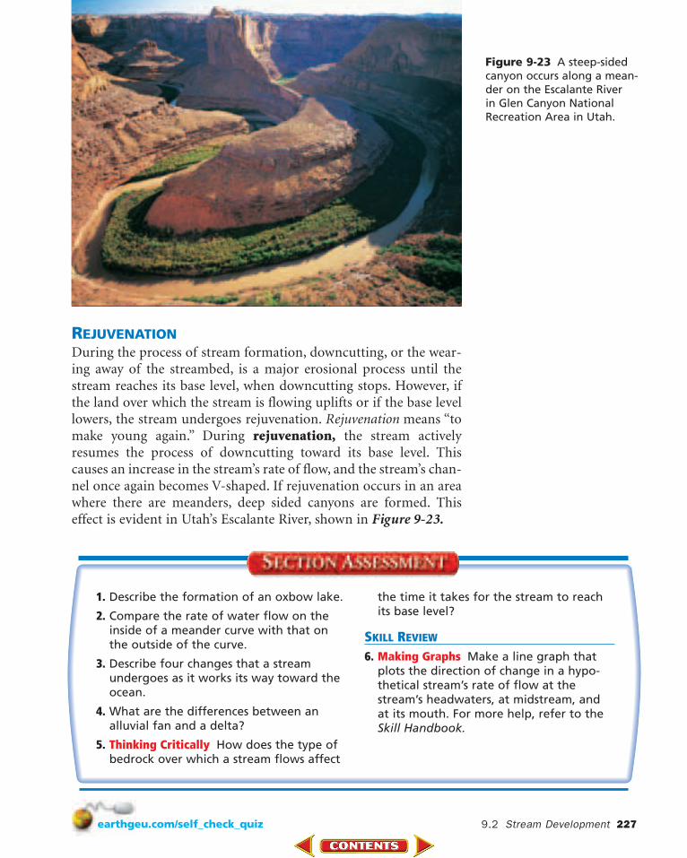
Figure 9-23 A steep-sidedcanyon occurs along a mean-der on the Escalante River in Glen Canyon NationalRecreation Area in Utah.
REJUVENATIONDuring the process of stream formation, downcutting, or the wear-ing away of the streambed, is a major erosional process until thestream reaches its base level, when downcutting stops. However, ifthe land over which the stream is flowing uplifts or if the base levellowers, the stream undergoes rejuvenation. Rejuvenation means “tomake young again.” During rejuvenation, the stream activelyresumes the process of downcutting toward its base level. Thiscauses an increase in the stream’s rate of flow, and the stream’s chan-nel once again becomes V-shaped. If rejuvenation occurs in an areawhere there are meanders, deep sided canyons are formed. Thiseffect is evident in Utah’s Escalante River, shown in Figure 9-23.
You have probably swum in, fished in, or gazed at the beauty of a lake.But, did you ever think about how lakes form? A lake is a depressionin the surface materials of a landscape that collects and holds water.As shown in the MiniLab on the following page, surface materialsdetermine where a lake can form. Lakes sometimes accumulate waterfrom streams and runoff that flow into them. Lakes also receive waterfrom local precipitation, springs, and other sources. Most lakes haveoutlets from which water flows to rivers and to the ocean. Peoplesometimes build small lakes called ponds to serve as sources of waterfor livestock, to maintain fish supplies, to attract wildlife, or for theirnatural beauty. Reservoirs are lakes made for the primary purpose ofstoring water for a community’s use.
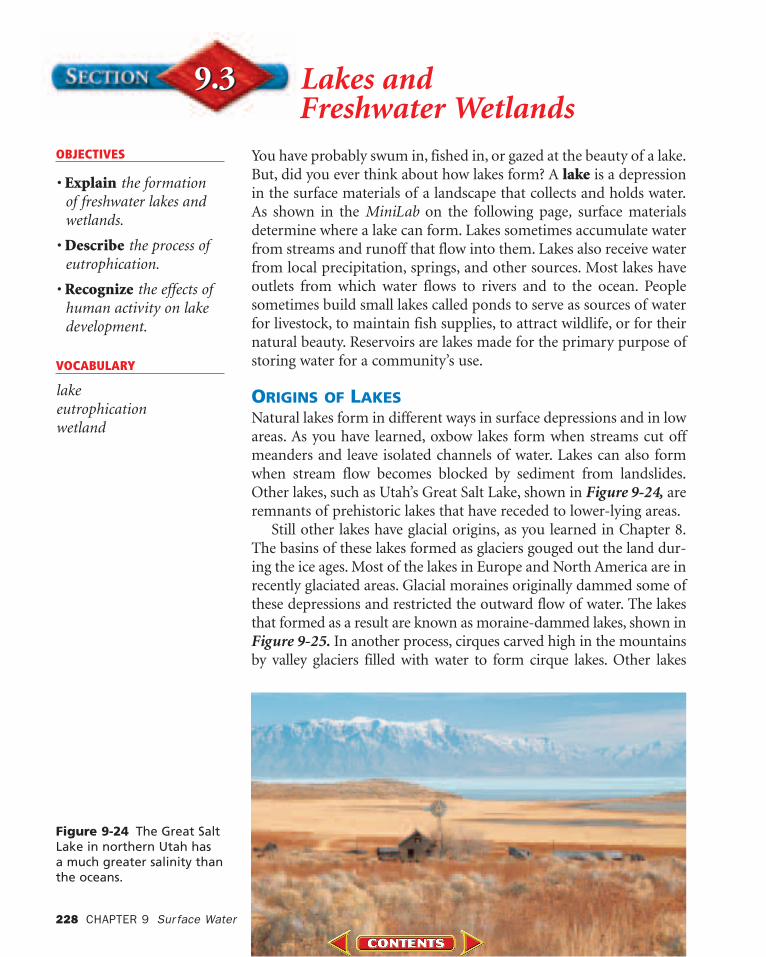
ORIGINS OF LAKESNatural lakes form in different ways in surface depressions and in lowareas. As you have learned, oxbow lakes form when streams cut offmeanders and leave isolated channels of water. Lakes can also formwhen stream flow becomes blocked by sediment from landslides.Other lakes, such as Utah’s Great Salt Lake, shown in Figure 9-24, areremnants of prehistoric lakes that have receded to lower-lying areas.
Still other lakes have glacial origins, as you learned in Chapter 8.The basins of these lakes formed as glaciers gouged out the land dur-ing the ice ages. Most of the lakes in Europe and North America are inrecently glaciated areas. Glacial moraines originally dammed some ofthese depressions and restricted the outward flow of water. The lakesthat formed as a result are known as moraine-dammed lakes, shown inFigure 9-25. In another process, cirques carved high in the mountainsby valley glaciers filled with water to form cirque lakes. Other lakes
OBJECTIVES
• Explain the formation of freshwater lakes andwetlands.
• Describe the process ofeutrophication.
• Recognize the effects ofhuman activity on lakedevelopment.
VOCABULARY
lakeeutrophication wetland
Figure 9-24 The Great SaltLake in northern Utah has a much greater salinity thanthe oceans.
228 CHAPTER 9 Sur face Water
formed as blocks of ice left on the outwashplain ahead of melting glaciers eventuallymelted and left depressions called kettles.When these depressions filled with water,they formed kettle lakes.
Many lakes are found in areas wherelimestone is the dominant bedrock. Asgroundwater percolating through limestonebedrock slowly dissolves calcium carbonate,it leaves holes in the limestone and formscaverns. In some places, the ceilings of thesecaverns become so thin and weak that theycollapse, which leaves depressions that mayfill with water in time.
LAKES UNDERGO CHANGEWater from precipitation, runoff, andunderground sources can maintain a lake’swater supply. Some lakes contain water onlyduring times of heavy rain or excessiverunoff from spring thaws. A depression thatreceives more water than it loses to evapora-tion or use by humans will exist as a lake fora long period of time. However, lakes aretemporary water-holding areas; over hun-dreds of thousands of years, lakes usually fillin with sediment and become part of a newlandscape.
Eutrophication Through the process ofphotosynthesis, plants add oxygen and wasteproducts to lake water. Animals that live in alake use the water’s oxygen and add wasteproducts to the water as they conduct theirlife processes. The decay process that occursafter plants and animals die also uses up dis-solved oxygen supplies. The amount of dis-solved oxygen helps determine the quality oflake water and its ability to support life.
9.3 Lakes and Freshwater Wetlands 229
Surface materials determinewhere a lake can form.
Model how different Earth materials mayallow lakes to form. Lakes form whendepressions or low areas fill with water.
Procedure CAUTION: Always wear safety goggles and an apron in the lab.
1. Use three clear, plastic shoe boxes. Half fill each one with Earth materials: clay,sand, and gravel.
2. Slightly compress the material in eachshoe box. Then make a shallow depressionin each surface.
3. Slowly pour 500 mL of water into each ofthe depressions.
Analyze and Conclude1. Describe what happened to the 500 mL of
water that was added to each shoe box.2. How is this activity similar to what actually
happens on Earth’s surface when a lakeforms?
3. What can you infer about the Earth mate-rials in which lakes most commonly form?
Figure 9-25 The moraine-dammed lakesin Banff National Park in Alberta, Canadawere formed from glacial activity.
Figure 9-27 This bog inNorway has acid-rich soilthat supports a variety oforganisms.
The process by which lakes become rich in nutrients from thesurrounding watershed, thereby resulting in a change in the kinds oforganisms in the lake, is called eutrophication. Figure 9-26 showsa pond undergoing eutrophication. Although eutrophication is anatural process, it can be sped up with the addition of nutrients,such as fertilizers, that contain nitrogen and phosphorus. When thishappens, the animal and plant communities in the lake can changerapidly. Algae growing in the water may suddenly multiply veryquickly. The excessive algae growth in a lake or pond appears asgreen scum. Other organisms that eat the algae can multiply innumbers as well. The resulting overpopulation and decay of a largenumber of plants and animals depletes the water’s oxygen supply.Fish and other sensitive organisms may die as a result of the lack ofoxygen in the water.
Other major sources of nutrients that concentrate in lakes areanimal wastes and phosphate detergents. Lakes can also suffer fromthe release of toxins from nearby industries and untreated sewage, asshown in the Science & the Environment feature at the end ofthe chapter.
Freshwater Wetlands A wetland is a land area that is coveredwith water for a large part of the year. Wetlands include environ-ments commonly known as bogs, marshes, and swamps. They havecertain soil types and support specific plant species.
A bog, shown in Figure 9-27, is an interesting wetland thatdeserves a closer look. Bogs are not stream-fed, but instead receivetheir water from precipitation. The waterlogged soil tends to be richin Sphagnum, also called peat moss. The breakdown of peat mossproduces acids, thereby contributing to the soil’s acidity. The water-logged, acidic soil supports unusual plant species, including insect-eating pitcher plants, sundew, and Venus’ flytrap.
Figure 9-26 The aquaticspecies of this pond willchange over the yearsbecause of the effects of eutrophication.
230 CHAPTER 9 Sur face Water
9.3 Lakes and Freshwater Wetlands 231
1. Describe the process of eutrophication.
2. What human activities affect the processof eutrophication?
3. What conditions are necessary for the for-mation of a natural lake?
4. Thinking Critically Describe a situation inwhich protection of wetlands may conflictwith human plans for land use.
SKILL REVIEW
5. Making Tables Design a data table thatcompares the various types of lakes, theirorigins, and their characteristics. For morehelp, refer to the Skill Handbook.
Freshwater marshes frequently form along themouths of streams and in areas with extensive deltas.The constant supply of water allows for the lushgrowth of marsh grasses. The shallow roots of thegrasses anchor deposits of silt and mud on the delta,thereby slowing the water and expanding the marsharea. Grasses, reeds, sedges, and rushes, along withabundant wildlife, are common in marsh areas.
Swamps are low-lying areas often located nearstreams. Swamps may develop from marshes that havefilled in sufficiently to support the growth of shrubsand trees. As these larger plants grow and begin toshade the marsh plants, the marsh plants die. Swampsthat existed 250 million years ago developed into present-day coal reserves that are common inPennsylvania and many other locations in the UnitedStates and around the world.
Wetlands play a valuable role in improving water quality. Theyserve as a filtering system that traps pollutants, sediments, and path-ogenic bacteria contained in water sources. Wetlands also providevital habitats for migratory waterbirds and homes for an abundanceof other wildlife, as shown in Figure 9-28. Unfortunately, people’sdesire for land often conflicts with the need to preserve wetlands. Inthe past, it was common for wetland areas to be filled in to createmore land on which to build. Government data reveal that from thelate 1700s to the mid-1980s, the continental United States lost 50percent of its wetlands. By 1985, it was estimated that 50 percent ofthe wetlands in Europe were drained. Now, however, the preservationof wetland areas has become a global concern.
Figure 9-28 The wetlandsin Bosque del ApacheNational Wildlife Refuge inNew Mexico are home tomigrating snow geese.
Water in streams flows from areas of higher elevation toareas of lower elevation. The rate of stream flow varies
from one stream to another and also in different areas of thesame stream.
ProblemDetermine how slope may affectstream-flow velocity.
Materials1-m length of vinyl gutter pipering stand and clampwater source with long hoseprotractor with plumb bobsink or container to catch waterstopwatchgrease pencilmeterstickpaperhole punch
ObjectivesIn this GeoLab, you will:• Measure the time it takes for water to
flow down a channel at differentslopes and depths.
• Organize your data in a table.• Plot the data on a graph to show how
stream velocity is directly propor-tional to the stream channel’s slopeand depth.
• Describe the relationship betweenslope and rate of stream flow.
Safety PrecautionsAlways wear safety goggles in the lab.
Preparation
232 CHAPTER 9 Sur face Water
GeoLab 233
1. Why is it important to keep thewater flow constant in this activity?
2. Which variables had to be con-trolled to avoid errors in your data?
3. Using your graph, predict the veloc-ity of water flow for a 35° slope.
1. What is the relationship between therate of water flow and the angle ofthe slope?
2. Describe one reason why a stream’sslope might change.
3. Where would you expect to findstreams with the highest water-flow velocity?
Analyze
Conclude & Apply
1. Use the hole punch to make 10 to15 paper circles to be used as float-ing markers.
2. Use the illustration below as a guideto set up the protractor with theplumb bob.
3. Use the grease pencil to mark twolines across the inside of the gutterpipe at a distance of 40 cm apart.
4. Use the ring stand and clamp tohold the gutter pipe at an angle of10°. Place the end of the pipe in asink or basin to collect the dis-charged flow of water.
5. Attach a long hose to a water faucetin the sink.
6. Keep the hose in the sink until youare ready to use it. Then turn on thewater and adjust the flow until thewater is moving quickly enough toprovide a steady flow.
7. Bend the hose temporarily to blockthe water flow until the hose is posi-tioned at least 5 cm above the topline marked on the pipe.
8. Keep the water moving at the samerate of flow for all slope anglesbeing investigated.
9. Drop a floating marker approxi-mately 4 cm above the top line on the pipe and into the flowing water.Measure the time it takes for thefloating marker to move from thetop line to the bottom line. Recordthe time in your science journal.
10. Repeat step 9 two more times.11. Repeat steps 9 and 10 but change the
slope to 20°, then 30°, and then 40°.12. Make a line graph of the average
stream-flow velocity.
Procedure
String
Protractor
Weight
90°
234 CHAPTER 9 Sur face Water
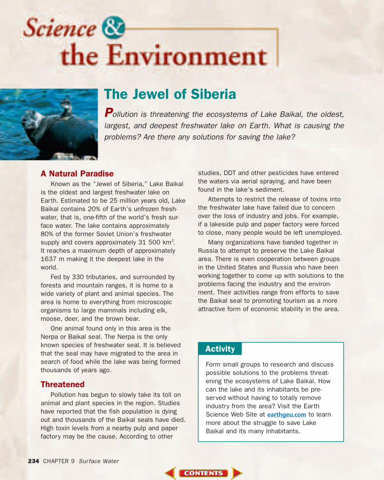
A Natural ParadiseKnown as the “Jewel of Siberia,” Lake Baikal
is the oldest and largest freshwater lake onEarth. Estimated to be 25 million years old, LakeBaikal contains 20% of Earth’s unfrozen fresh-water, that is, one-fifth of the world’s fresh sur-face water. The lake contains approximately 80% of the former Soviet Union’s freshwater supply and covers approximately 31 500 km2.It reaches a maximum depth of approximately1637 m making it the deepest lake in the world.
Fed by 330 tributaries, and surrounded byforests and mountain ranges, it is home to awide variety of plant and animal species. Thearea is home to everything from microscopicorganisms to large mammals including elk,moose, deer, and the brown bear.
One animal found only in this area is theNerpa or Baikal seal. The Nerpa is the onlyknown species of freshwater seal. It is believedthat the seal may have migrated to the area insearch of food while the lake was being formedthousands of years ago.
Threatened Pollution has begun to slowly take its toll on
animal and plant species in the region. Studieshave reported that the fish population is dyingout and thousands of the Baikal seals have died.High toxin levels from a nearby pulp and paperfactory may be the cause. According to other
The Jewel of SiberiaPollution is threatening the ecosystems of Lake Baikal, the oldest,largest, and deepest freshwater lake on Earth. What is causing theproblems? Are there any solutions for saving the lake?
Form small groups to research and discusspossible solutions to the problems threat-ening the ecosystems of Lake Baikal. Howcan the lake and its inhabitants be pre-served without having to totally removeindustry from the area? Visit the EarthScience Web Site at earthgeu.com to learnmore about the struggle to save LakeBaikal and its many inhabitants.
Activity
studies, DDT and other pesticides have enteredthe waters via aerial spraying, and have beenfound in the lake’s sediment.
Attempts to restrict the release of toxins intothe freshwater lake have failed due to concernover the loss of industry and jobs. For example,if a lakeside pulp and paper factory were forcedto close, many people would be left unemployed.
Many organizations have banded together inRussia to attempt to preserve the Lake Baikalarea. There is even cooperation between groupsin the United States and Russia who have beenworking together to come up with solutions to theproblems facing the industry and the environ-ment. Their activities range from efforts to savethe Baikal seal to promoting tourism as a moreattractive form of economic stability in the area.
Main Ideas• Water on Earth may follow a variety of pathways as it is recycled
through the processes of evaporation and condensation.• Infiltration of water into the ground depends on the number of
open pores or spaces in Earth materials and on the presence ofunsaturated pores in the ground.
• All the land area that drains into a stream system is the system’swatershed, or drainage basin. Elevated land areas called dividesseparate one watershed from another.
• A stream’s load is all the material the stream carries, includingmaterial in solution, in suspension, and as bed load.
• A floodplain is a broad, flat area that extends out from a stream’sbank during times of flooding.
• Flooding occurs in small, localized areas as upstream floods or inlarge, downstream floods. Damage from flooding can be devastating.
Main Ideas• Water from precipitation gathers in gullies at a stream’s source
area, or headwaters. The stream’s water flows in channels con-fined by the stream’s banks.
• Alluvial fans and deltas form when stream velocity decreasesand sediment is deposited. Alluvial fans are fan shaped, andthey form where water flows down steep slopes onto flat plains.Deltas are triangular, and they form when streams enter large,relatively quiet bodies of water.
Main Ideas• Lakes form in a variety of ways when depressions on land fill
with water. Lakes may be natural or human-made.• Eutrophication is a natural nutrient enrichment process that may
be sped up when nutrients from fertilizers, detergents, orsewage are added.
• Wetlands are low-lying areas that are periodically saturated withwater and support specific plant species. Wetlands include bogs,marshes, and swamps.
SECTION 9.1
Surface WaterMovement
SECTION 9.2
StreamDevelopment
SECTION 9.3
Lakes andFreshwaterWetlands
Study Guide 235earthgeu.com/vocabulary_puzzlemaker
1. Which factor least affects the rate of runoff?a. slope c. volume of runoffb. vegetation d. nearness to water
2. What areas are most likely to contain fertile soils?a. watersheds c. floodplainsb. dried-up streambeds d. mountainous areas
3. Which substance is most likely to be carried by a stream in solution?a. quartz c. calciteb. sand d. silt
4. What material plays a major role in the eutro-phication of lakes?a. iron c. ozoneb. phosphate d. salt
5. During the process of eutrophication, what happens to the oxygen present in a lake?a. It increases. c. It stays the same.b. It decreases. d. It evaporates.
6. What kind of streams form V-shaped valleys?a. streams that are first formingb. streams that carry much sedimentc. streams that move slowlyd. streams that have meanders
7. Where does water move most rapidly in thestraight length of a stream?a. along the bottom c. near the surfaceb. along the sides d. in the center
8. If a stream is carrying sand, silt, clay, and smallpebbles, which one is deposited last as thestream begins to slow down?a. clay c. sandb. silt d. small pebbles
Understanding Main Ideas 9. Where do alluvial fans form?a. on the outside of meandersb. where streams enter the oceanc. near lakesd. along the bases of mountains
10. In what ways are a delta and an alluvial fan simi-lar, and in what ways are they different?
11. Why is it important to preserve wetlands?
12. What means do governments use to try to prevent the loss of life and property in flood-prone areas?
Use the following aerial view of a stream to answerquestions 13–15.
Applying Main Ideas
BEAT THE CLOCK—AND THEN GO BACKAs you take a practice test, pace yourself to fin-ish each section just a few minutes early so youcan go back and check over your work. You willsometimes find a mistake or two.
1. Which condition would create the mostrunoff?a. land covered with vegetationb. plants in densely packed soilc. light precipitationd. soil with a high percentage of sand
2. In which part of a meander does the watertravel the fastest?a. the water that moves along the inside
curve of the meanderb. the water that moves along the
bottom of the meanderc. the water that moves along the
outside curve of a meanderd. all water flows at the same rate
3. Which of the following is NOT a value ofwetlands?a. feeding lakes and deltas with nutrient-
and oxygen-rich water b. filtering water by trapping pollutants,
sediments, and pathogenic bacteriac. providing habitats for migratory birds
and other wildlifed. preserving fossils due to the anaerobic
and acidic conditions
4. As the velocity of a stream decreases, whichtransported particle size would settle to thestream’s bottom first?a. clay c. pebbleb. silt d. sand
5. Which condition helps determine the qualityof lake water?a. the amount of nitrogenb. the amount of dissolved calcium carbonatec. the amount of potassiumd. the amount of dissolved oxygen
13. At which location in the aerial view does thestream’s water have the greatest velocity?
14. At which location is deposition most activelyoccurring?
15. At which location is erosion most actively occurring?
16. What is the discharge of a stream that has a velocity of 300 m/s and is 25-m wide and 3-m deep?
17. Why is a lake with a clay bottom able to holdmore water than a lake with a sand bottom?
18. One morning, there was a torrential thunder-storm. In the afternoon, the skies cleared and agardener decided to plant a tree. After digging inthe ground only a short distance down, the gar-dener found that the ground was very dry. Howcould the ground be dry despite the heavy rainsearlier in the day?
19. If floodplains are such hazardous areas to live in,why have so many people settled in these poten-tial flood zones?
20. Use the following terms to construct a conceptmap to organize the major ideas in Section 9.1.For more help, refer to the Skill Handbook.