Page 1
6
CHAPTER II
Regional Geology of Assam
2.1 Geology of Assam-Arakan Basin
The state of Assam is located near the northeast corner of India between the
latitudes of 24º and 28º and longitudes of 90º and 96º. The State covers the plains
areas of the Brahmputra and Barak valleys, the Mikir Hills Plateau, the North
Cachar Hills, the plains and hill areas of Cachar district and some marginal
plateau and hill areas adjoining the neighbouring states. Geologically, the rocks
that make up Assam extend in age from very ancient early Proterozoic to the
present day Alluvium. Within the Brahmputra valley, the rocks at these extreme
ends can be seen at the surface, but much of those of intermediate age are buried
under the alluvium.
A Geological map of Assam-Arakan basin is shown in Map 2.1
Map 2.1: Geological Map of Assam Arakan Basin (after OIL’s unpublished
report)
Page 2
7
2.1.1 Tectonic Evolution
The tectonic evolution of Assam can be understood in the context of cyclic
global geotectonic phenomenon – Plate Tectonics and Ocean Floor Spreading.
According to Plate Tectonics theory, during a cycle lasting 500 million years or
so, the continental masses of the crust fuse together to form one or more super-
continents, only to start rifting and breaking apart with ocean floor spreading to
keep the breakaway continental fragments moving away from each other.
Eventually, the drifting fragments or plates collide with other similar masses in
their way and begin forming a new super-continent. Along the line of junction,
one plate gets subducted below the other with a lot of sedimentation and
mountain building activity at the zone of collision.
At the beginning of the current Plate Tectonic cycle, Assam (together with rest
of India, Tibet, Australia, Antarctica, Africa and South America) was part of a
super continent called Gondwanaland. The landmass was made up primarily of
ancient metamorphics of Archaean to Early Proterozoic age. Around 250 million
years ago (Permian) this super-continent started to develop a number of rift
valleys. From Late Paleozoic to Early Cretaceous, the Gondwanaland itself
started to break up in stages. With Ocean floor spreading in between, large
chunks of erstwhile super-continent moved away from mainland with both
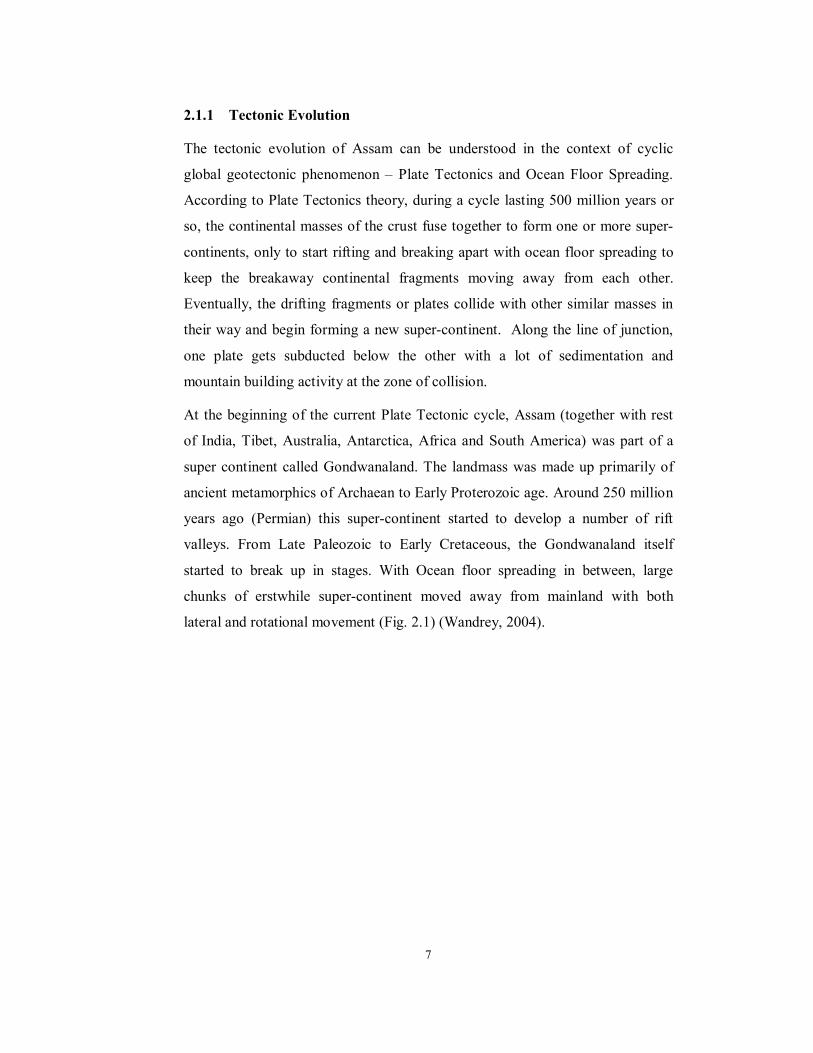
lateral and rotational movement (Fig. 2.1) (Wandrey, 2004).
Page 3
8
Figure 2.1: Gondwanaland during a) Middle Jurassic (166 Ma) and b)
Early Cretaceous (130 Ma) (after Wandrey, 2004)
a b
Figure 2.2: Movement of Indian Plate during a) Late Cretaceous (94
Ma) and b) Late Cretaceous (69 Ma) (after Wandrey,
2004)
a b
Page 4
9
During this journey, some of the chunks remained large, like Australia, some got
fragmented, some joined together with accompanying collision tectonics to
former larger landmasses (Fig. 2.2). Eventually, a large chunk of these fragments
and composite chunks from north-eastern Gondwanaland collided and fused with
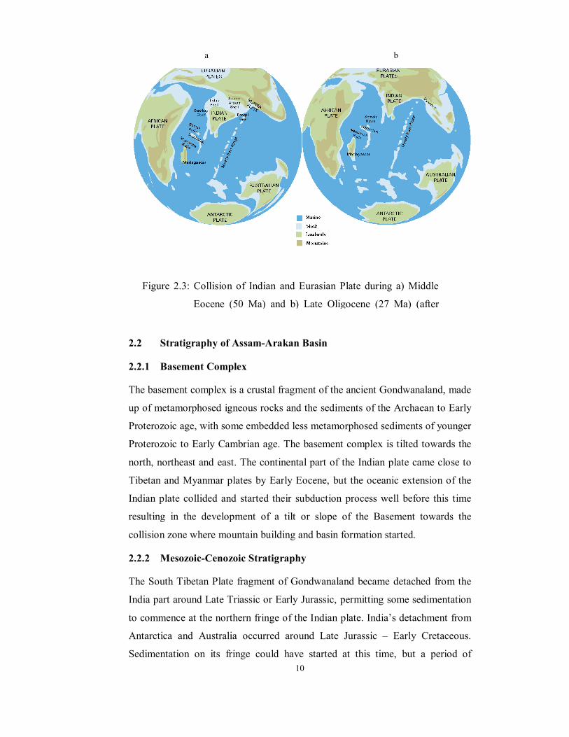
the Eurasian plate (Fig. 2.3). The drifting phase started during the Late Jurassic –
Early Cretaceous. The collision of the continental masses commenced around
Early Eocene and multiple phases of mountain building and mountain-front
basin formation has continued since then. The present day basins are reflected by
the Brahmputra, Kopili, Dhansiri and Surma-Barak alluvial plains. Much of the
earlier continental crust is buried deep under these basins. Some have been
elevated as the Shillong and Mikir Hills Plateaus and their associated hills. Parts
of the northern continental margin could have been either subducted or caught up
in the faulting and folding activity of Indo-Tibetan collision zone.
In the course of its geological history, Assam has thus passed through five
important phases. The first of these relates to when it was a part of Gondwana
super-continent. The second phase came in the Permo-Carboniferous, when its
adjoining areas were rifted and the coal-bearing Gondwana was deposited. The
third phase came in Late Triassic / Early Jurassic when, with the drifting away of
Southern Tibet, the northern fringe of India including the part that is now Assam
became open to marine sedimentation. The fourth phase started when the eastern
boundary also broke apart in Late Jurassic – Early Cretaceous and the southern
and eastern shores of Assam became open to marine sedimentation. This phase
also saw the beginning of some igneous activity with the outpouring of Garo
Hills, Sylhet and Mikir Hills Traps (basalts). The fifth phase started with its
collision with Myanmar to the east and Tibet to the north around Early Eocene
and continued with all the stages of collision tectonics thereafter. During this
phase, the entire land was caught up between two collision zones. The Mishmi
Hills added a third compressional force from the northeast and subsequently a
major uplift of Shillong-Mikir Hills Plateau also contributed.
Page 5
10
2.2 Stratigraphy of Assam-Arakan Basin
2.2.1 Basement Complex
The basement complex is a crustal fragment of the ancient Gondwanaland, made
up of metamorphosed igneous rocks and the sediments of the Archaean to Early
Proterozoic age, with some embedded less metamorphosed sediments of younger
Proterozoic to Early Cambrian age. The basement complex is tilted towards the
north, northeast and east. The continental part of the Indian plate came close to
Tibetan and Myanmar plates by Early Eocene, but the oceanic extension of the
Indian plate collided and started their subduction process well before this time
resulting in the development of a tilt or slope of the Basement towards the
collision zone where mountain building and basin formation started.
2.2.2 Mesozoic-Cenozoic Stratigraphy
The South Tibetan Plate fragment of Gondwanaland became detached from the
India part around Late Triassic or Early Jurassic, permitting some sedimentation
to commence at the northern fringe of the Indian plate. India’s detachment from
Antarctica and Australia occurred around Late Jurassic – Early Cretaceous.
Sedimentation on its fringe could have started at this time, but a period of
Figure 2.3: Collision of Indian and Eurasian Plate during a) Middle
Eocene (50 Ma) and b) Late Oligocene (27 Ma) (after
a b
Page 6
11
igneous activity intervened leading to formation of Rajmahal, Sylhet and other
related basaltic lava flows (Traps) and intrusives. Therefore, sedimentation
started some time later.
Basinwards, the shelf slopes down to a prominent hinge zone, beyond which the
entire Cretaceous-Eocene section turns in to a thick group of indurated shales
with some sandstones and occasional thin bands of fossiliferous limestones,
known as the Disangs. The Disang Fault or Thrust demarcates the position of the
hinge up to approximately the longitude of 92º 20’ E. Within Assam, Disangs
have a very restricted presence and are confined to a narrow belt to the south and
east of Disang thrust in North Cachar.
As the South Tibet and Myanmar Plate fragments broke apart from the
Gondwanaland from about Late Triassic to Early Jurassic, there was ocean floor
spreading between these and India leading to the formation of large ocean floor
extensions in the corresponding parts of India and these plate fragments. As the
South Tibet and Myanmar Plate fragments joined up with Eurasia around Mid-
Cretaceous and India continued to close the gap, the oceanic extension of the
India Plate started to get consumed through subduction. This was accompanied
by basin formation and compressional tectonics in the collision zone.
2.2.3 Palaeogene Stratigraphy
At around Mid-Cretaceous, when the collision between the oceanic extensions of
India Plate with those of its neighbours first started, the sediments of the shelf
areas and the collision zone were several thousand kilometres apart. But as the
continental part of India closed in, the gap slowly decreased, so that by Late
Eocene the shelf and the peripheral tectonic basins had come reasonably close to
each other. The configuration of the colliding Indian and Myanmar continental
masses were such that collision started at the north-eastern end and progressively
extended southwards.
In the northern outcrops of Sylhet and Cachar, Eocene Kopilis were overlain
conformably by a thick group of sandstone and shales which formed the Barail
Range of the area. They were accordingly given the name of Barails and the
Barail Range became its type area. Similarly local names were given based on
Page 7
12
the lithological associations. For example, a sandstone-shale sequence named
Bhubans from the Bhuban Hills to the southeast of Silchar’s Cachar, a shaly
sequence named Boka Bils from their association with a muddy lake on the west
flank of Masimpur anticline in Cachar, a sequence of massive sandstone named
Tipams after the low Tipam range and the Tipam river in northeast Assam and a
sequence of mottled clays and sands named after Giru Jan to the east of Digboi.
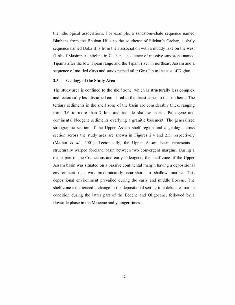
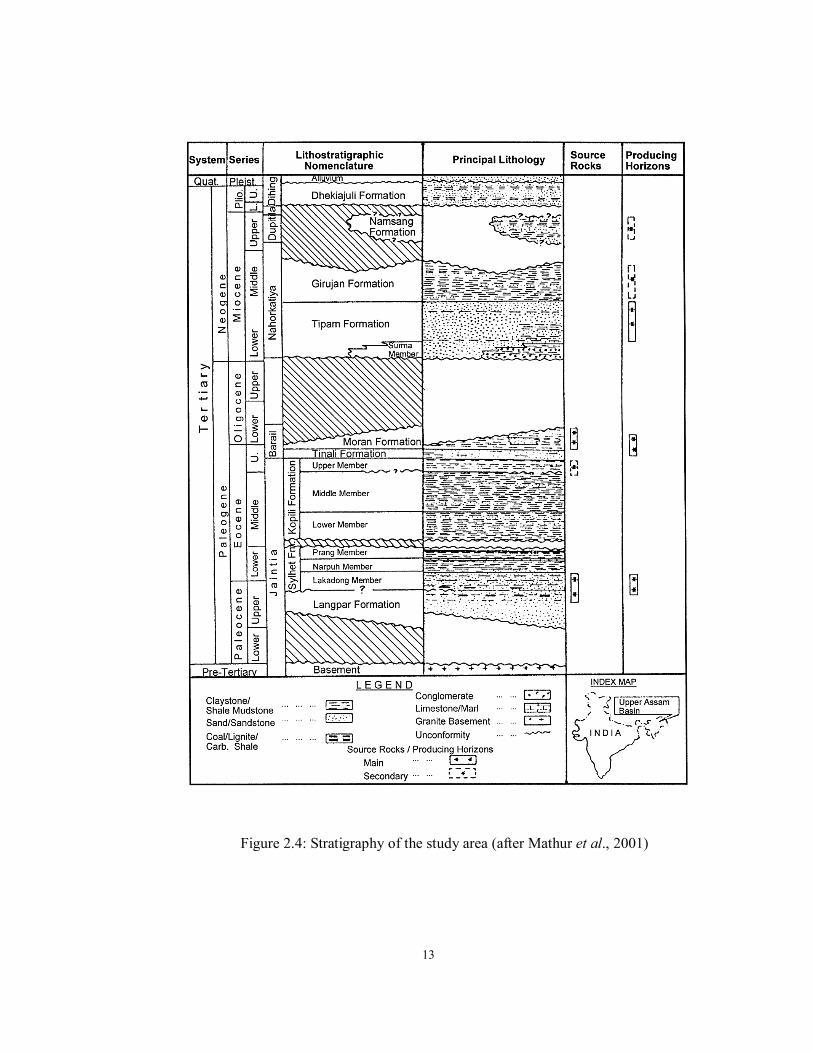
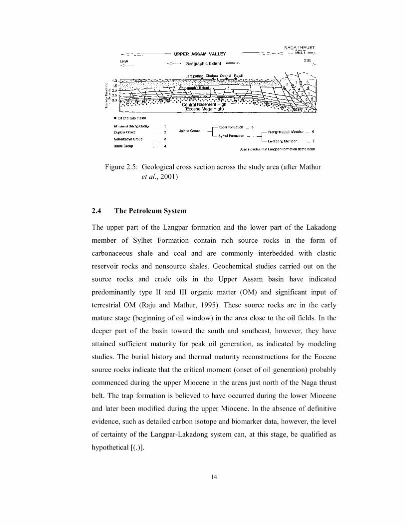
2.3 Geology of the Study Area
The study area is confined to the shelf zone, which is structurally less complex
and tectonically less disturbed compared to the thrust zones to the southeast. The
tertiary sediments in the shelf zone of the basin are considerably thick, ranging
from 3.6 to more than 7 km, and include shallow marine Paleogene and
continental Neogene sediments overlying a granitic basement. The generalized
stratigraphic section of the Upper Assam shelf region and a geologic cross
section across the study area are shown in Figures 2.4 and 2.5, respectively
(Mathur et al., 2001). Tectonically, the Upper Assam basin represents a
structurally warped foreland basin between two convergent margins. During a
major part of the Cretaceous and early Paleogene, the shelf zone of the Upper
Assam basin was situated on a passive continental margin having a depositional
environment that was predominantly near-shore to shallow marine. This
depositional environment prevailed during the early and middle Eocene. The
shelf zone experienced a change in the depositional setting to a deltaic-estuarine
condition during the latter part of the Eocene and Oligocene, followed by a
fluviatile phase in the Miocene and younger times.
Page 8
13
Figure 2.4: Stratigraphy of the study area (after Mathur et al., 2001)
Page 9
14
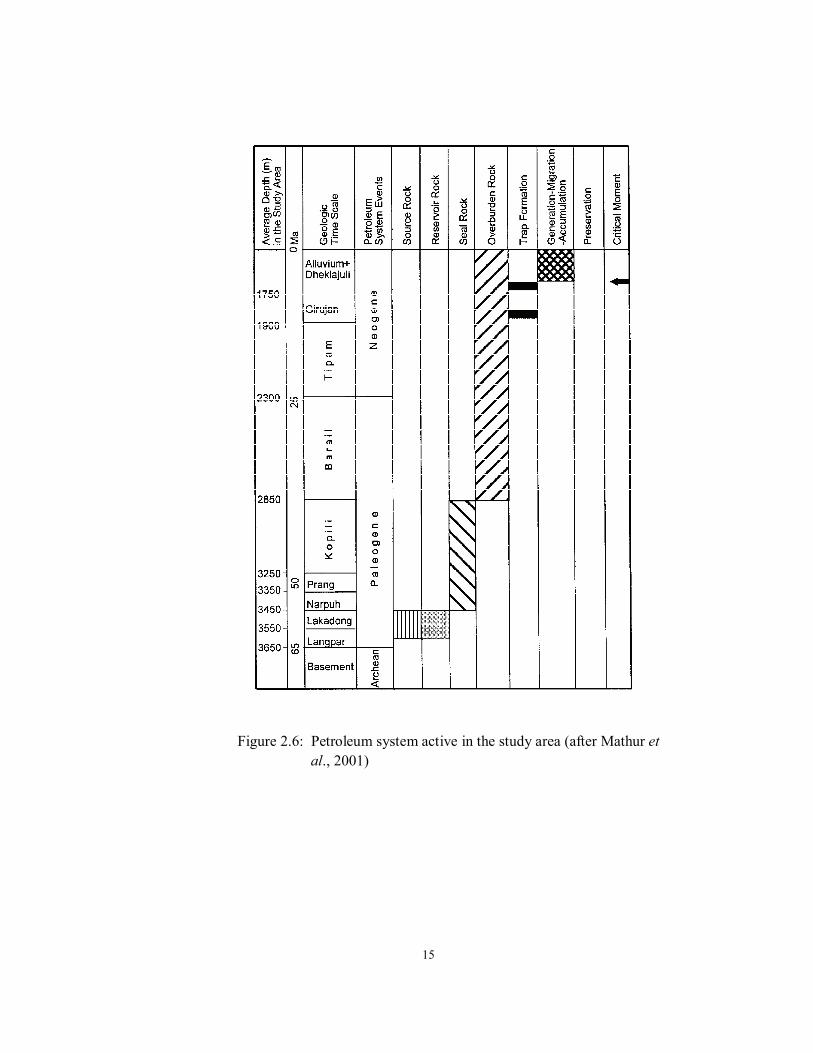
2.4 The Petroleum System
The upper part of the Langpar formation and the lower part of the Lakadong
member of Sylhet Formation contain rich source rocks in the form of
carbonaceous shale and coal and are commonly interbedded with clastic
reservoir rocks and nonsource shales. Geochemical studies carried out on the
source rocks and crude oils in the Upper Assam basin have indicated
predominantly type II and III organic matter (OM) and significant input of
terrestrial OM (Raju and Mathur, 1995). These source rocks are in the early
mature stage (beginning of oil window) in the area close to the oil fields. In the
deeper part of the basin toward the south and southeast, however, they have
attained sufficient maturity for peak oil generation, as indicated by modeling
studies. The burial history and thermal maturity reconstructions for the Eocene
source rocks indicate that the critical moment (onset of oil generation) probably
commenced during the upper Miocene in the areas just north of the Naga thrust
belt. The trap formation is believed to have occurred during the lower Miocene
and later been modified during the upper Miocene. In the absence of definitive
evidence, such as detailed carbon isotope and biomarker data, however, the level
of certainty of the Langpar-Lakadong system can, at this stage, be qualified as
hypothetical [(.)].
Figure 2.5: Geological cross section across the study area (after Mathur
et al., 2001)
Page 10
15
Figure 2.6: Petroleum system active in the study area (after Mathur et
al., 2001)
Page 11
16
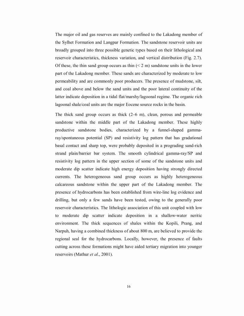
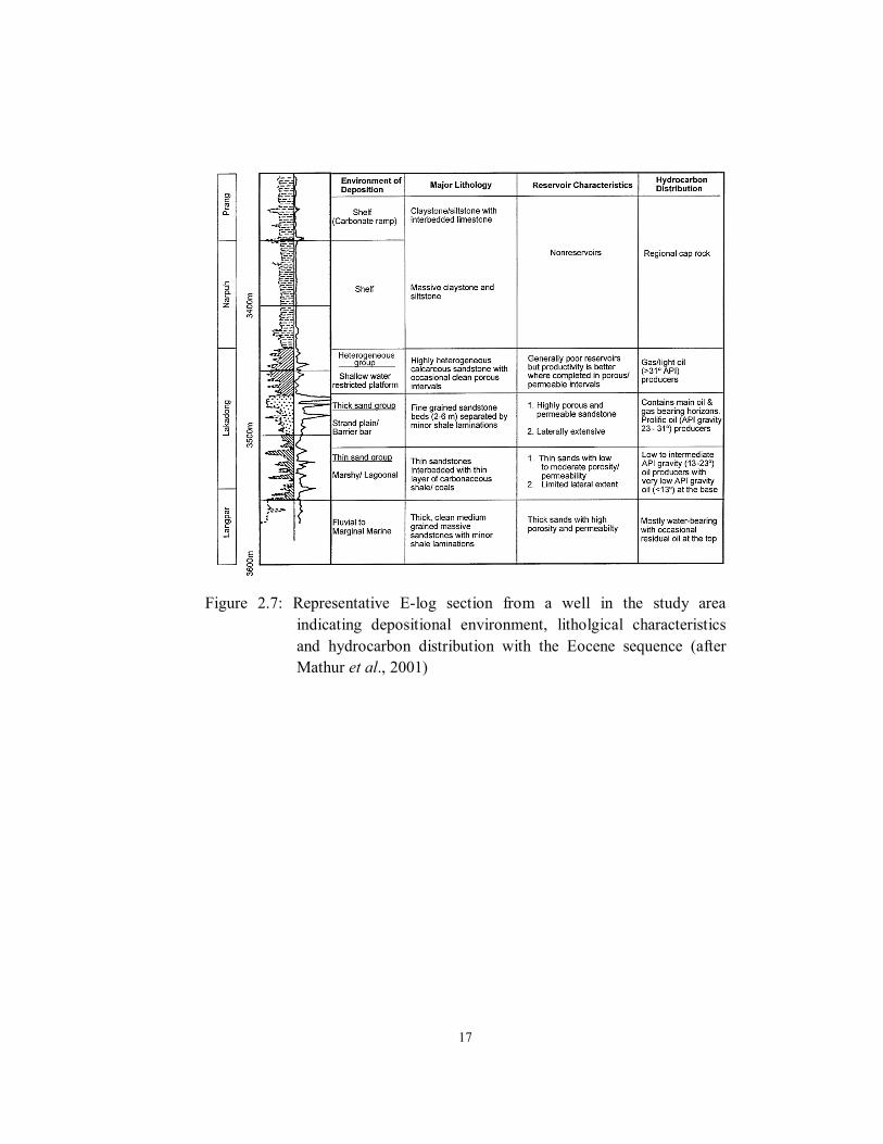
The major oil and gas reserves are mainly confined to the Lakadong member of
the Sylhet Formation and Langpar Formation. The sandstone reservoir units are
broadly grouped into three possible genetic types based on their lithological and
reservoir characteristics, thickness variation, and vertical distribution (Fig. 2.7).
Of these, the thin sand group occurs as thin (< 2 m) sandstone units in the lower
part of the Lakadong member. These sands are characterized by moderate to low
permeability and are commonly poor producers. The presence of mudstone, silt,
and coal above and below the sand units and the poor lateral continuity of the
latter indicate deposition in a tidal flat/marshy/lagoonal regime. The organic rich
lagoonal shale/coal units are the major Eocene source rocks in the basin.
The thick sand group occurs as thick (2–6 m), clean, porous and permeable
sandstone within the middle part of the Lakadong member. These highly
productive sandstone bodies, characterized by a funnel-shaped gamma-
ray/spontaneous potential (SP) and resistivity log pattern that has gradational
basal contact and sharp top, were probably deposited in a prograding sand-rich
strand plain/barrier bar system. The smooth cylindrical gamma-ray/SP and
resistivity log pattern in the upper section of some of the sandstone units and
moderate dip scatter indicate high energy deposition having strongly directed
currents. The heterogeneous sand group occurs as highly heterogeneous
calcareous sandstone within the upper part of the Lakadong member. The
presence of hydrocarbons has been established from wire-line log evidence and
drilling, but only a few sands have been tested, owing to the generally poor
reservoir characteristics. The lithologic association of this unit coupled with low
to moderate dip scatter indicate deposition in a shallow-water neritic
environment. The thick sequences of shales within the Kopili, Prang, and
Narpuh, having a combined thickness of about 800 m, are believed to provide the
regional seal for the hydrocarbons. Locally, however, the presence of faults
cutting across these formations might have aided tertiary migration into younger
reservoirs (Mathur et al., 2001).
Page 12
17
Figure 2.7: Representative E-log section from a well in the study area
indicating depositional environment, litholgical characteristics
and hydrocarbon distribution with the Eocene sequence (after
Mathur et al., 2001)