Chapter One – The Restless Earth The Restless Earth 1.1 Plate tectonics and where the Earth's plates are 1.2 Types of plate margin 1.3 Fold mountains, ocean trenches, composite volcanoes and shield volcanoes. 1.4 Andes Case study 1.5 Volcanoes Background 1.6 Mount Pinatubo - a case study of a volcanic eruption 1.7 Supervolcanoes 1.8 Earthquakes Background 1.9. Kobe - an earthquake in an MEDC 1.10 Haiti - an earthquake in an LEDC 1.11 Tsunami The Coolgeography book by Rob Gamesby is licensed under a Creative Commons Attribution- NonCommercial 3.0 Unported License.
Transcript
Chapter One – The Restless Earth
The Restless Earth
1.1 Plate tectonics and where the Earth's plates are 1.2 Types of plate margin 1.3 Fold mountains, ocean trenches, composite volcanoes and shield volcanoes. 1.4 Andes Case study 1.5 Volcanoes Background 1.6 Mount Pinatubo - a case study of a volcanic eruption 1.7 Supervolcanoes 1.8 Earthquakes Background 1.9. Kobe - an earthquake in an MEDC 1.10 Haiti - an earthquake in an LEDC 1.11 Tsunami
The Coolgeography book by Rob Gamesby is licensed under a Creative Commons Attribution-NonCommercial 3.0 Unported License.
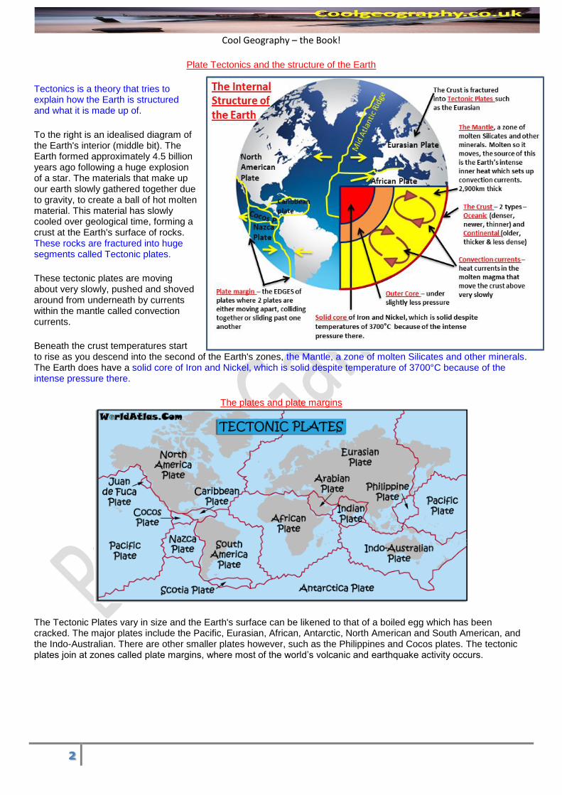
Tectonics is a theory that tries to explain how the Earth is structured and what it is made up of.
To the right is an idealised diagram of the Earth's interior (middle bit). The Earth formed approximately 4.5 billion years ago following a huge explosion of a star. The materials that make up our earth slowly gathered together due to gravity, to create a ball of hot molten material. This material has slowly cooled over geological time, forming a crust at the Earth's surface of rocks. These rocks are fractured into huge segments called Tectonic plates.
These tectonic plates are moving about very slowly, pushed and shoved around from underneath by currents within the mantle called convection currents.
Beneath the crust temperatures start to rise as you descend into the second of the Earth's zones, the Mantle, a zone of molten Silicates and other minerals. The Earth does have a solid core of Iron and Nickel, which is solid despite temperature of 3700°C because of the intense pressure there.
The plates and plate margins
The Tectonic Plates vary in size and the Earth's surface can be likened to that of a boiled egg which has been cracked. The major plates include the Pacific, Eurasian, African, Antarctic, North American and South American, and the Indo-Australian. There are other smaller plates however, such as the Philippines and Cocos plates. The tectonic plates join at zones called plate margins, where most of the world’s volcanic and earthquake activity occurs.
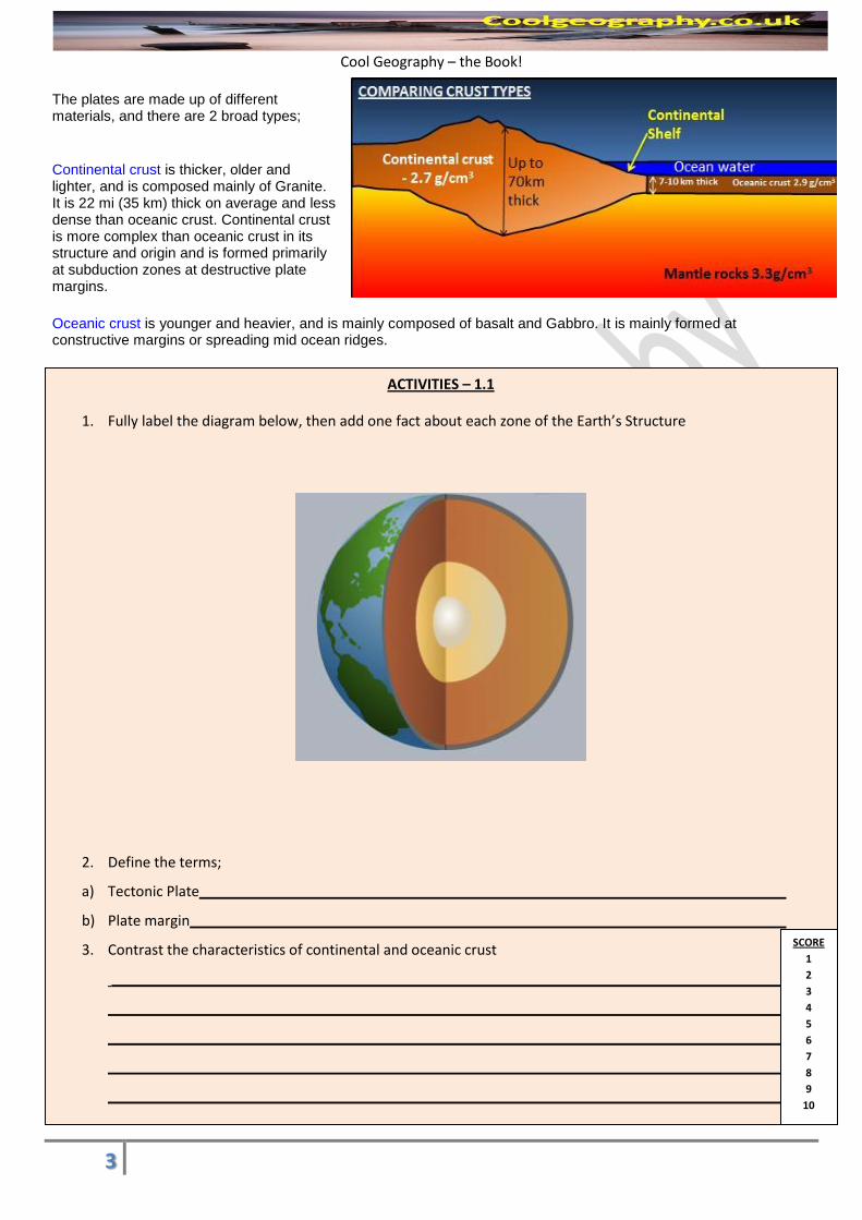
The plates are made up of different materials, and there are 2 broad types;
Continental crust is thicker, older and lighter, and is composed mainly of Granite. It is 22 mi (35 km) thick on average and less dense than oceanic crust. Continental crust is more complex than oceanic crust in its structure and origin and is formed primarily at subduction zones at destructive plate margins.
Oceanic crust is younger and heavier, and is mainly composed of basalt and Gabbro. It is mainly formed at constructive margins or spreading mid ocean ridges.
ACTIVITIES – 1.1
1. Fully label the diagram below, then add one fact about each zone of the Earth’s Structure
2. Define the terms;
a) Tectonic Plate
b) Plate margin
3. Contrast the characteristics of continental and oceanic crust
SCORE
1
2
3
4
5
6
7
8
9
10
Cool Geography – the Book!
4
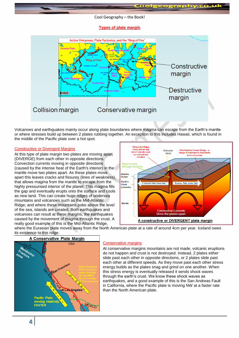
Types of plate margin
Volcanoes and earthquakes mainly occur along plate boundaries where magma can escape from the Earth’s mantle or where stresses build up between 2 plates rubbing together. An exception to this includes Hawaii, which is found in the middle of the Pacific plate over a hot spot.
Constructive or Divergent Margins
At this type of plate margin two plates are moving apart (DIVERGE) from each other in opposite directions. Convection currents moving in opposite directions (caused by the intense heat of the Earth's interior) in the mantle move two plates apart. As these plates move apart this leaves cracks and fissures (lines of weakness), that allows magma from the mantle to escape from the highly pressurised interior of the planet. This magma fills the gap and eventually erupts onto the surface and cools as new land. This can create huge ridges of undersea mountains and volcanoes such as the Mid-Atlantic Ridge; and where these mountains poke above the level of the sea, islands are created. Both earthquakes and volcanoes can result at these margins, the earthquakes caused by the movement of magma through the crust. A really good example of this is the Mid-Atlantic Ridge, where the Eurasian plate moves away from the North American plate at a rate of around 4cm per year. Iceland owes its existence to this ridge.
Conservative margins
At conservative margins mountains are not made, volcanic eruptions do not happen and crust is not destroyed. Instead, 2 plates either slide past each other in opposite directions, or 2 plates slide past each other at different speeds. As they move past each other stress energy builds as the plates snag and grind on one another. When this stress energy is eventually released it sends shock waves through the earth’s crust. We know these shock waves as earthquakes, and a good example of this is the San Andreas Fault in California, where the Pacific plate is moving NW at a faster rate than the North American plate.
Cool Geography – the Book!
5
Destructive or Convergent Margins
At these margins 2 plates move or CONVERGE together and the Destruction of some of the Earth's crust results. An oceanic plate (denser) is pushed towards a continental plate (less dense) by convection currents deep within the Earth's interior. The oceanic plate is subducted (pushed under) the continental plate at what is called a subduction zone, creating a deep ocean trench. It is the Oceanic crust which sinks down into the mantle because it is denser (heavier). As it descends friction, increasing pressure and heat from the mantle melt the plate. Some of this molten material can work its way up through the continental crust through fissures and cracks in the crust to collect in magma chambers. This is often some distance from the margin where magma can eventually re-emerge at the surface to create a range of mountains. The movement of the plates grinding past one another can create earthquakes, when one plate eventually slips past the other releasing seismic energy. There are several really good examples of Destructive plate margins, including along the West coast of the Americas and Japan, where the Philippines sea plate is pushed under the Eurasian plate.
Collisional
At these margins 2 plates of similar density are forced toward each other. Neither plate descends into the mantle because of the similar density of the plates. Instead, the 2 plates crumple into one another and fold upwards into Fold Mountains. At these margins we get Fold Mountains and earthquake activity, and a fantastic example of this is the Himalayan Mountains. Here, the Indo Australian plate is colliding with the Eurasian plate and has done so for millions of years. Originally, there used to be a sea called the Tethys Sea between India and Asia, but over time India has collided into Eurasia creating huge fold mountains rich in marine (sea) fossils!
Cool Geography – the Book!
6
ACTIVITIES 1.2
1. Add the following labels to the satellite image of a CONSTRUCTIVE plate margin below – North American
Plate, Eurasian Plate, The Mid Atlantic Ridge, Fault lines, West Africa and South West Ireland
2. Complete the flow chart below to explain exactly what happens at Destructive plate margins. Mention
subduction, oceanic crust, continental crust, earthquakes and volcanoes in your flow chart.
3. Explain why we get earthquakes but not volcanoes at CONSERVATIVE plate margin
1
2
3 •
4
5
6
SCORE
1
2
3
4
5
6
7
8
9
10
Cool Geography – the Book!
7
Landforms found at plate boundaries
The 4 basic landforms that you need to know found at plate boundaries are Fold Mountains, mid ocean ridges, ocean trenches and types of volcano. Fold Mountains are large mountain ranges where the layers of rock within them have been crumpled as they have been forced together. They can be formed at destructive or collisional plate boundaries, where tectonic plates are moving together forcing layers of rock to be crumpled upwards.
The process of formation is as follows; 1) Sediments accumulate in shallow seas or depressions as rivers enter those areas. 2) This creates a sea or lake bed of layered sedimentary rocks as compression takes place. 3) Two plates move together because of convection currents in the mantle 4) This starts to crumple the rocks together. 5) The rocks start to form folds which have anticlines and synclines, which are pushed upwards to form fold mountains. 6) These mountains are then subject to erosion, weathering and mass movement (denudation)
Ocean Trenches
These are deep water areas that run along a coastline which has a destructive plate margin. They are created by subduction, and mark the point where the Oceanic crust is being pushed under the Oceanic crust.
There is often quite a large section of continental crust between this margin and the ocean's edge, and sometimes a volcanic island arc such as Japan can be found in between the trench and the continental shelf.
These are not to be confused with mid ocean ridges, which are long ridges of mountains created by 2 plates moving apart at a constructive plate margin. Where these mountains rise above the level of the sea, Islands such as Iceland are formed.
ACTIVITIES 1.3
1. DISTINGUISH between Ocean trenches and Mid Ocean Ridges
2. For each stage of the fold mountains diagram explain what is happening and how they form.
75,000 people were evacuated due to accurate predictions. There was no monitoring until the 3rd of April but seismometers were put into place.
The United States Geological Service helped to predict the disaster
75,000 people evacuated up to a radius of 30km. USA air force helicopters helped.
Alert systems put into place to warn of eruption.
Government Shelters.
Evacuation camps built for refugees.
Warning sign like gas and steam looked for. Long and short term aid organized especially from the Red Cross and the United States
What they could have done
Set up permanent monitoring points or use satellite images to look upon volcano site for changes in land surface.
Placed strategies for long term aid and disease control in evacuations prepared for.
Storage of medical supplies food and water in preparation for disaster.
ACTIVITIES 1.6
1. Draw a sketch map of the location of Mount Pinatubo including the Island of Luzon, the Eurasian Plate and the
Philippines plate.
2. Rank the Impacts of Mount Pinatubo from 1 (worst impact) to 12 (least severe impact)
Rank
847 People Killed - 300 from collapsing roofs , 100 from the mud flows known as lahars, the rest from disease in the evacuation centres including measles.
1.2million people lost homes and had to migrate to shanty towns in Manila
Electricity went off, water was contaminated, road links were destroyed, and telephone links were cut
58,000people had to be evacuated from a 30km radius of the volcano
650,000 workers lost jobs
$700 Million Damages
Houses and bridges destroyed and needed replacing and Manila airport had to be closed
Farmland destroyed by falling ash and pumice, unusable for years, the 1991 harvest was destroyed and 650,000 people lost their jobs
Volcanic ash is blown in all directions over hundreds of KMs, smothering fields and buildings.
Heavy rainfall from Typhoon Yunga causes buildings to collapse.
Fast flowing volcanic mudflows (lahars) cause severe river bank erosion, undercut bridges etc.
Global cooling caused by ash in the atmosphere of 0.5°C
3. Explain your ranking:
4. Was Mount Pinatubo well managed? Justify your response
SCORE
1
2
3
4
5
6
7
8
9
10
Cool Geography – the Book!
15
Supervolcanoes
The Toba Super Eruption
The last supervolcano to erupt was 74000 years ago in Indonesia, when a gigantic volcanic eruption shook the earth. The ash was thrown out 3000km, created global cooling and created a crater larger than the city of London. This super eruption created Lake Toba, 100km long and 50km wide. A supervolcano such as Toba could reduce temperatures globally by 5 degrees Celsius – enough to spark an ice age and ruin agriculture globally!
Just a few thousand people lived on earth at the time – but what would happen if this struck the USA? A super eruption could affect whole world and badly affect the USA. The USA has a supervolcano in the shape of Yellowstone National Park .
What are supervolcanoes?
Supervolcanoes are hard to spot and need a minimum of 1,000km3 of eruptible material. Whereas, regular composite volcanoes (such as Mount Pinatubo) have a cone shape, supervolcanoes are depressions in the ground. The Calderas are so large they can sometimes only be spotted from space and have been identified in Indonesia, in New Zealand, in South America and an extinct one in Glen Coe in England. Yellowstone is still active, and is America’s most famous and popular National Parks. Over 3 million people visit the park every year, but do they know they are visiting a time bomb?
Supervolcanoes are not mountains – they form DEPRESSIONS within the Earth’s crust. They begin with a column of magma rising through a vent into the Earth’s crust. The magma gets stuck and pools, melting the rock around for thousands of years. Over thousands of years the pressure builds up and when the eruption eventually happens it drains the magma lake and the land above collapse down over, creating a caldera.
Supervolcanoes are eruptions and explosions of catastrophic proportions, on the Volcano Explosivity Index (VEI) supervolcanoes are an 8 on a scale that runs from 1 to 8. Each leap up the scale represents an increase of explosive scale of 10 times the power. Mount St Helens was VEI 5!
Massive lake Toba, in the caldera of a super volcano
The volcano at Yellowstone is close to 100km across, and Yellowstone National park has hot springs and geysers and is known to be geothermal.
What exists beneath Yellowstone is a hot spot, where magma moves upwards in the Mantle, hits the base of the earth’s crust and melts it creating a huge chamber of magma. The hot spot is static but the Earth’s crust moves over it. Therefore there have been many craters across the US caused by this hot spot. 2 million years ago this hotspot settled under Yellowstone. The mountain range around Yellowstone is interrupted by the 2.1million year’s caldera explosion – this swallowed 80 km worth of mountains. Since then, there have been 2 more explosions, 1.3million years ago and 640000 years ago – a cycle of 600,000 to 700,000 years.
Scientists discovered that the magma chamber is 80km long, 40km wide and 8km deep.
If Yellowstone erupts it will be disastrous for the whole world. The magma will push the dome up, earthquakes will occur, allowing fissures to crack the surface allowing pressure release, lava to escape and columns of ash to be ejected 10s of kilometres into the air, pyroclastic flows would kill thousands of people. The ash would cover the Great Plains stopping grain production, economic activity in the US would be affected, and global climate would be changed, stopping the growing season.
ACTIVITIES 1.7
1. List 4 characteristic features of a supervolcano
a)
b)
c)
d)
2. Describe where supervolcanoes are located using the map on the previous page.
3. Outline the potential global and national impacts of a super volcanic eruption at Yellowstone National Park.
SCORE
1
2
3
4
5
6
7
8
9
10
Cool Geography – the Book!
17
Earthquakes
Earthquakes are vibrations in the Earth's crust that cause shaking at the
surface. They are highly unpredictable and often occur suddenly without
warning, mainly on the plate margins. We do know where most earthquakes will
occur, and they tend to coincide with destructive, conservative, collisional and
constructive plate margins.
Reasons for Earthquakes happening
1. Earthquakes occur because stresses build up between the plates as one
plate passes another.
2. As the plates move past one another they don't do so smoothly, rather, they snag and grind, allowing energy
to build up.
3. When the plates eventually move again this energy is released as shock or seismic waves through the Earth's
crust.
4. The point at which this slippage occurs is called the FOCUS, whilst the point on the ground surface
above the earthquake FOCUS is called the EPICENTRE.
5. Seismic shock waves will go radially outwards from these points and their energy will reduce with distance.
Earthquakes can also occur at constructive plate margins. Here, the earthquake is the result of magmas forcing its
way between the plates, causing the earth to tremble. Collisional margins, where continental crust meets continental
crust, can also have earthquakes as a result of the pressures generated by collision.
Earthquake waves
The first waves in an earthquake will shake the ground UP then Down in a longitudinal movement. These
waves are called P or PRIMARY waves. They travel fastest, and can also cause back and forth movement. These
waves are relatively weak and cause the surface to move in a back and forth motion. The next waves to arrive are S
or Secondary waves, which travel slower through the crust. These waves cause the crust to move from side
to side at right angles to the outward motion of the main wave.
How Earthquakes are
measured
Earthquakes can be
measured using 2
scales -the Richter
scale or the Mercalli
scale. The Mercalli
scale measures the
effects of the
earthquake and runs
from 1 to 12. The
higher up the scale the
more damage is
experienced by people
and building structures.
The Richter scale is
different in that it
measures the energy
of an earthquake.
The scale is
logarithmic, which
means that for every
jump up the scale you
Cool Geography – the Book!
18
get a tenfold increase in power of an earthquake. Therefore a magnitude 6 is 10 times more powerful than a
magnitude 5, and 100 times more powerful than a magnitude 4. The higher the magnitude of an earthquake the less
frequent its occurrence. The largest ever recorded was in Valvidia in Chile in 1960 and recorded 9.5 on the scale.
Reasons why Earthquake damage varies
Population Density - the more densely populated an area the more potential there is for loss of life and damage to
property. One of the reasons for the huge extent of the damage caused by the earthquake which hit Kobe was the
fact that the area is very densely populated.
Earthquake depth - generally, the deeper the focus of the earthquake in the Earth's crust the less damage that is
caused. This is because the waves lose energy as they travel through the crust, so by the time they reach the surface
the damage can be minimised.
Building design - Buildings can be designed to withstand the shaking of the earth and to limit the loss of life and
damage caused. The Transamerica pyramid has a shape that can withstand seismic waves and withstood the 1989
Loma Prieta earthquake which struck San Francisco. Other strategies include rolling weights on the roofs of buildings,
shatterproof glass to prevent scattering glass during a quake, emergency shutters for glass, gas shut off valves and
identification numbers on buildings.
Earthquake strength - the stronger the earthquake the more damage would be caused. This is explained in how we
measure earthquakes above.
Geology - the rock type of the area in which the earthquake occurs. If the area is solid rock there is generally less
damage than on sands and clays. On clays, liquefaction can occur, where water penetrates between the clay
particles creating a quick sand like substance into which buildings can sink.
ACTIVITIES 1.8
1. Explain how the following factors affect the level of earthquake damage
Earthquake strength
Geology
Earthquake depth
Population density
Building design
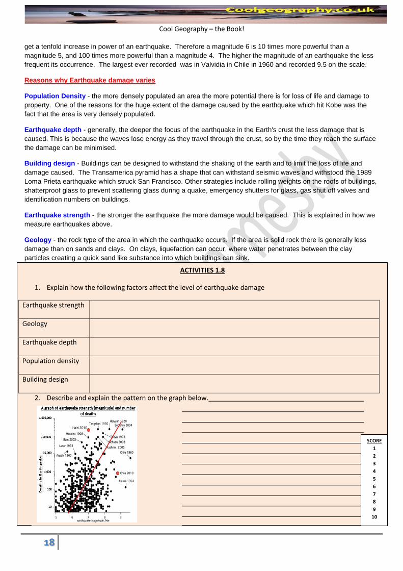
2. Describe and explain the pattern on the graph below.
SCORE
1
2
3
4
5
6
7
8
9
10
Cool Geography – the Book!
19
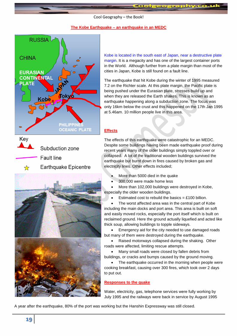
The Kobe Earthquake – an earthquake in an MEDC
Kobe is located in the south east of Japan, near a destructive plate
margin. It is a megacity and has one of the largest container ports
in the World. Although further from a plate margin than most of the
cities in Japan, Kobe is still found on a fault line.
The earthquake that hit Kobe during the winter of 1995 measured
7.2 on the Richter scale. At this plate margin, the Pacific plate is
being pushed under the Eurasian plate, stresses build up and
when they are released the Earth shakes. This is known as an
earthquake happening along a subduction zone. The focus was
only 16km below the crust and this happened on the 17th Jan 1995
at 5.46am. 10 million people live in this area.
Effects
The effects of this earthquake were catastrophic for an MEDC.
Despite some buildings having been made earthquake proof during
recent years many of the older buildings simply toppled over or
collapsed. A lot of the traditional wooden buildings survived the
earthquake but burnt down in fires caused by broken gas and
electricity lines. Other effects included;
More than 5000 died in the quake
300,000 were made home less
More than 102,000 buildings were destroyed in Kobe,
especially the older wooden buildings.
Estimated cost to rebuild the basics = £100 billion.
The worst affected area was in the central part of Kobe
including the main docks and port area. This area is built on soft
and easily moved rocks, especially the port itself which is built on
reclaimed ground. Here the ground actually liquefied and acted like
thick soup, allowing buildings to topple sideways.
Emergency aid for the city needed to use damaged roads
but many of them were destroyed during the earthquake.
Raised motorways collapsed during the shaking. Other
roads were affected, limiting rescue attempts.
Many small roads were closed by fallen debris from
buildings, or cracks and bumps caused by the ground moving.
The earthquake occurred in the morning when people were
cooking breakfast, causing over 300 fires, which took over 2 days
to put out.
Responses to the quake
Water, electricity, gas, telephone services were fully working by
July 1995 and the railways were back in service by August 1995
A year after the earthquake, 80% of the port was working but the Hanshin Expressway was still closed.
Cool Geography – the Book!
20
By January 1999, 134,000 housing units had been constructed but some
people still had to live in temporary accommodation.
New laws were passed to make buildings and transport structures even more
earthquake proof.
More instruments were installed in the area to monitor earthquake
movements.
Most new buildings and roads have, in the last 20 years, been designed to be
earthquake proof, schools and factories have regular earthquake drills, etc.
Despite this, many older buildings still collapsed or caught fire. This led to many blocked roads and massive problems
of homelessness.
Electricity and water supplies were badly damaged over large areas. This meant no power for heating, lights, cooking,
etc. Clean, fresh water was in short supply until April 1995. The government and city authorities were criticised for
being slow to rescue people and for refusing offers of help from other countries.
Many people had to sleep in cars or tents in cold winter conditions
Solutions;
Preparation – A lot of the buildings in Kobe and Japan made after the 1960s are earthquake proof (necessary by law)
with counterweights on the roofs and cross steel frames. Many of the damaged buildings in Kobe were built before
this period and were made of wood, which caught fire. People are educated on earthquake preparation in Japan.
Prediction – Japan has the world’s most comprehensive prediction programme with thousands of seismometers and
monitoring stations in Japan designed to give warning. Kobe hadn’t had an earthquake in 400years and had less
prediction equipment than other areas of Japan.
Aid – The Japanese rejected international offers of aid and dealt with the earthquake itself. All of the homeless people
were dealt with reasonably quickly and the city recovered thanks to government money.
Haiti Earthquake, Caribbean (LEDC)
ACTIVITIES 1.9
Complete the case study table to summarise the ESSENTIAL information about this earthquake;
Background (where, when, size)
Causes
Effects Short term
Long term
Responses Individuals
Agencies
Governments
SCORE
1
2
3
4
5
6
7
8
9
10
Cool Geography – the Book!
21
Haiti is the poorest country in the Western Hemisphere, its
GDP is only $1,200 per person, 207th in the world, and its
HDI is incredibly low at 0.404, 145th in the world, and 80 % of
its 9.7 Million people live below the poverty line.
Port Au Prince, the capital, is on a fault line running off the
Puerto Rico Trench, where the North American Plate is
sliding under the Caribbean plate. There were many
aftershocks after the main event. The earthquake occurred
on January 12th 2010, the epicentre was centred just 10
miles southwest of the capital city, Port au Prince and
the quake was shallow—only about 10-15 kilometres
below the land's surface. The event measured 7.0 on the
Richter Magnitude scale.
There were many impacts including;
•316,000 people died and more than a million people were
made homeless, even in 2011 people remained in make shift
temporary homes. Large parts of this impoverished nation
were damaged, most importantly the capital Port Au Prince, where shanty towns and even the presidential palace
crumbled to dust. 3 million people in total were affected. Few of the Buildings in Haiti were built with earthquakes in
mind, contributing to their collapse
•The government of Haiti also estimated that 250,000 residences and 30,000 commercial buildings had collapsed or
were severely damaged. The port, other major roads and
communications link were damaged beyond repair and needed
replacing. The clothing industry, which accounts for two-thirds
of Haiti's exports, reported structural damage at manufacturing
facilities. It is estimated the 1 in 5 jobs were lost as a result of
the quake
•Rubble from collapsed buildings blocked roads and rail links.
• The port was destroyed
• Sea levels in local areas changed, with some parts of the land
sinking below the sea
• The roads were littered with cracks and fault lines
Short term responses
Many countries responded to appeals for aid, pledging funds and dispatching rescue and medical teams, engineers
and support personnel.
Communication systems, air, land, and sea transport facilities, hospitals, and electrical networks had been damaged
by the earthquake, which slowed rescue and aid efforts.
There was much confusion over who was in charge, air traffic
congestion, and problems with prioritisation of flights further
complicated early relief work.
Port-au-Prince's morgues were quickly overwhelmed with many
tens of thousands of bodies having to be buried in mass graves.
Cool Geography – the Book!
22
As rescues tailed off, supplies, medical care and sanitation became priorities.
Delays in aid distribution led to angry appeals from aid workers and survivors, and looting and sporadic violence were
observed.
Long term recovery:
The EU gave $330 million and the World Bank waived the countries debt repayments for 5 years.
The Senegalese offered land in Senegal to any Haitians who wanted it!
6 months after the quake, 98% of the rubble remained uncleared, some still blocking vital access roads.
The number of people in relief camps of tents and tarps since the quake was 1.6 million, and almost no
transitional housing had been built. Most of the camps had no electricity, running water, or sewage disposal,
and the tents were beginning to fall apart.
Between 23 major charities, $1.1 billion had been
collected for Haiti for relief efforts, but only two percent
of the money had been released
One year after the earthquake 1 million people remained
displaced
The Dominican Republic which neighbours Haiti offered
support and accepted some refugees.
Medicines San Frontiers, a charity, tried to help
casualties whilst the USA took charge of trying to
coordinate Aid distribution.
ACTIVITIES 1.11
1. Describe the location of the Haïti earthquake using the map on the previous page
2. Complete the Venn diagram below to compare the similarities and differences between the Haïti and Kobe
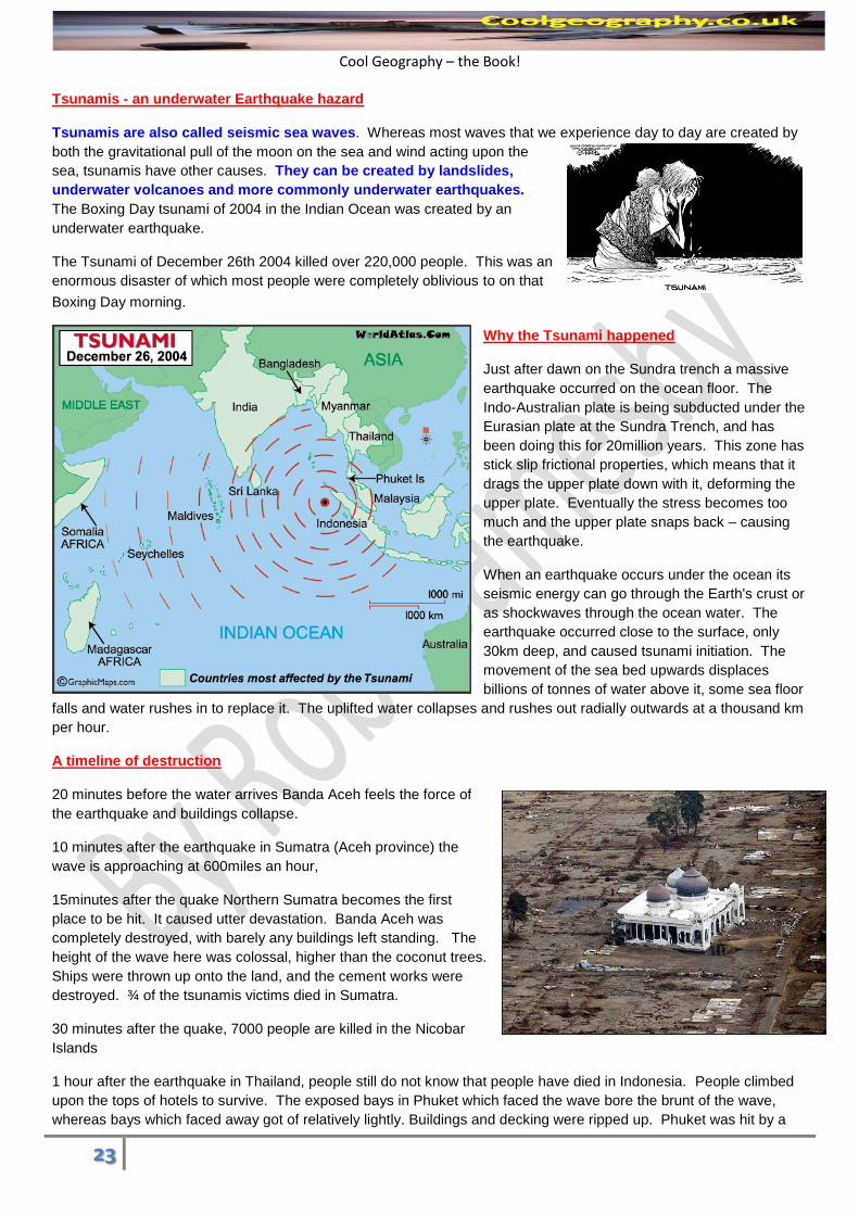
second wave 15 minutes later, which was even bigger than the first wave. Multiple waves in Tsunamis are normal.
The second wave rolled around the whole of Kamala bay. As the water retreats back out to sea it pulled cars, debris,
fishing boats and people back out with it.
2 hours after the earthquake, the wave reaches Sri Lanka. A train was running along the coast from Colombo to
Galle. The train was hit by the wave of water, and split the train up. The second wave arrived soon after, killing most
of the people who had survived the first wave on the train. 1500 people died on the train, 45,000 people died in India
and Sri Lanka.
3 ¾ hours after the quake, the Maldives are only slightly effected.
7 hours after the quake, East Africa is next affected. News is finally getting to communities and in Kenya there was
only one fatality as people were warned. The wave dissipates throughout the whole ocean across the globe.
There were no water level sensors, no warning systems and no disaster plans. This all contributed to the high death
toll.
Overall effects;
By the end of the day of the 2004 Indian Ocean tsunami, it had already killed 150,000 people. The final death
toll was 283,000.
The Indian Ocean tsunami travelled as far as 3,000 miles to Africa and still arrived with sufficient force to kill
people and destroy property.
Many people in Indonesian reported that they saw animals fleeing for high ground minutes before the tsunami
arrived – very few animal bodies were found afterward.
The risk of famine and epidemic diseases was extremely high immediately following the tsunami – bodies
rotting in the tropical heat contaminated food and water sources.
1.7 million people were displaced
Responses
SHORT TERM RESPONSES LONGTERM RESPONSES
INDIVIDUALS
Most individuals ran (Fled) for their lives. They climbed buildings, hills and trees. Some people Froze, they walked to the sea side to watch the wave approach and could not escape once they realised what they faced.
Many people have re-established buildings and businesses in the affected regions, but many people permanently migrated from the area.
GOVERNMENTS
The governments of the affected countries reacted reasonably quickly but were reliant in many cases on OUTSIDE AID due to the magnitude of the disaster and the lower level of economic development of the places affected. India sent naval ships to affected areas, whilst Thailand, Indonesia responded but slowly, given the extent of the disaster.
The World Health Organization warned that the number of deaths from preventable diseases such as cholera and typhoid could rival the death toll from the disaster itself.
The USGS managed to get a warning to Africa which saved lives
Country governments helped to rebuild whole community towns, including in Indonesia in Aceh province
An early warning system for Tsunami has now been put in place in the Indian Ocean, through co-operation from many governments
The DEC Earthquake/Tsunami disaster appeal fund stood at £32 million, up £7 million in one night from the 31st of December.
Countries sent aid teams immediately while MEDCs such as the UK sent dog teams, forensic experts and equipment to help identify bodies and clean up after the Tsunami
NON - GOVERNMENT ORGANISATIONS
Action Aid raised £13million and immediately sent food aid.
In the long run Action Aid offered Psychological counselling, paid for housing, paid for boats with motors for fishing communities, rebuilt schools and community centres, in an attempt to rebuild areas.
Cool Geography – the Book!
25
ACTIVITIES 1.12
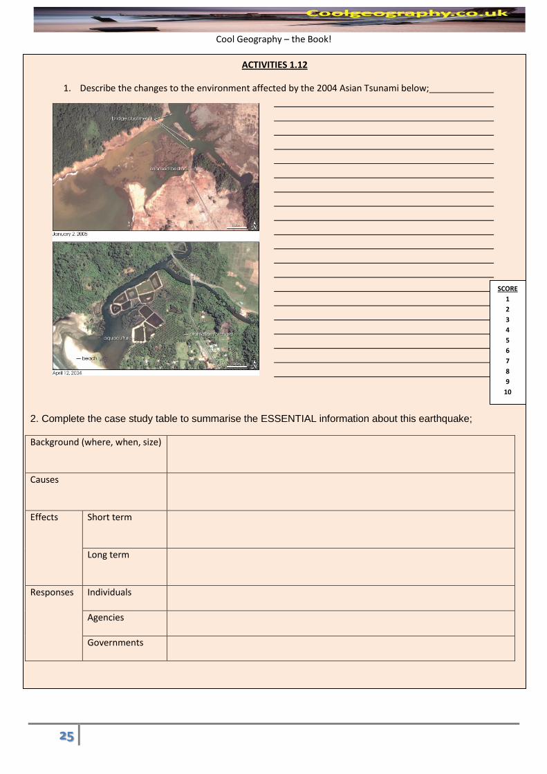
1. Describe the changes to the environment affected by the 2004 Asian Tsunami below;
2. Complete the case study table to summarise the ESSENTIAL information about this earthquake;
Background (where, when, size)
Causes
Effects Short term
Long term
Responses Individuals
Agencies
Governments
SCORE
1
2
3
4
5
6
7
8
9
10
Cool Geography – the Book!
26
Exam style Questions
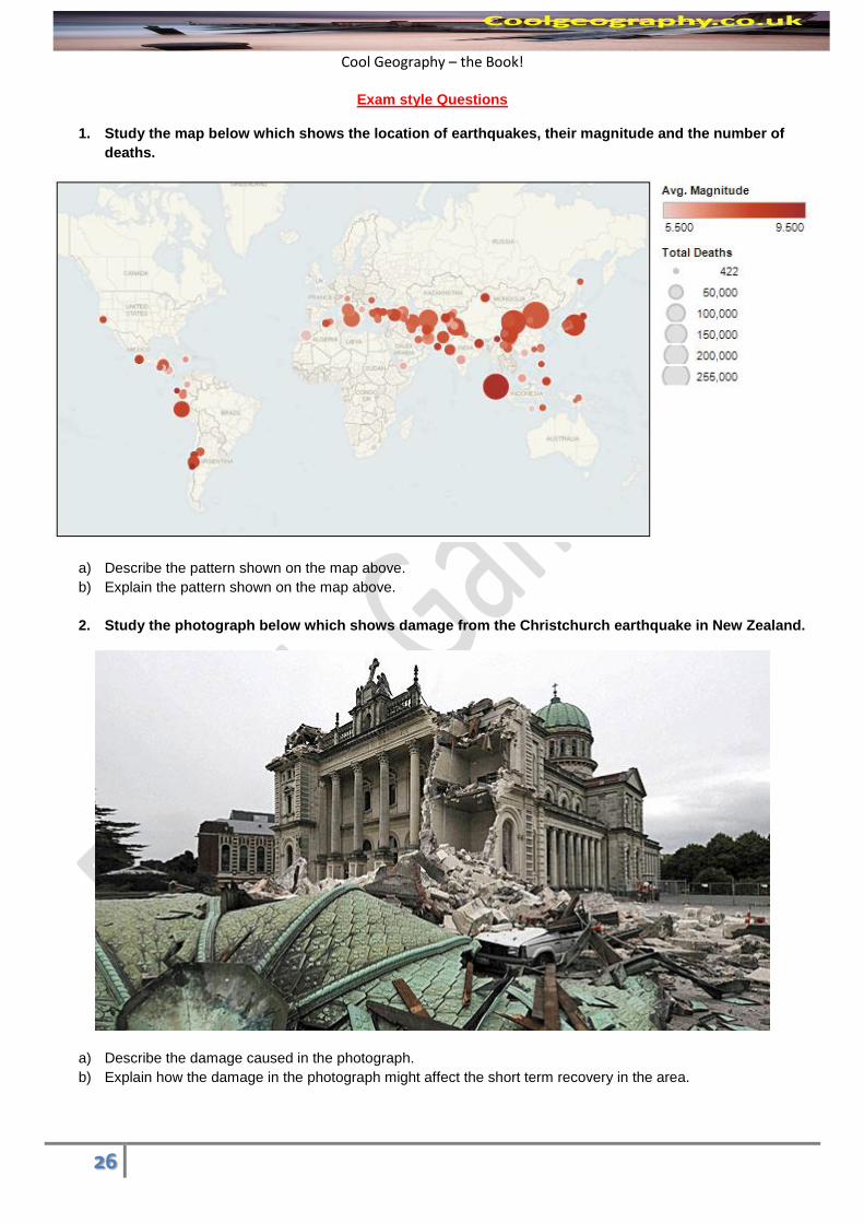
1. Study the map below which shows the location of earthquakes, their magnitude and the number of
deaths.
a) Describe the pattern shown on the map above.
b) Explain the pattern shown on the map above.
2. Study the photograph below which shows damage from the Christchurch earthquake in New Zealand.
a) Describe the damage caused in the photograph.
b) Explain how the damage in the photograph might affect the short term recovery in the area.
Cool Geography – the Book!
27
3. People respond to hazards in different ways. Choose a volcano or an earthquake you have studied in an LEDC. Describe the measures to predict and to take precautions against your chosen hazard and explain the short term responses to your chosen hazard.
4. Choose a volcanic eruption you have studied. Describe the aid given to people affected by the eruption and Explain the long term recovery of the area affected by the volcanic eruption.
5. People respond to Tsunami in different ways. Choose a Tsunami you have studied. Explain how people responded in the short term and the long term.
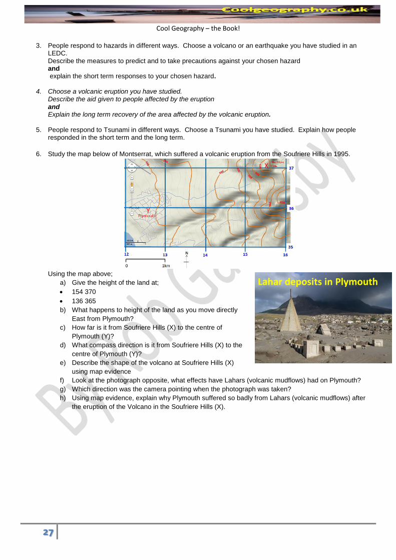
6. Study the map below of Montserrat, which suffered a volcanic eruption from the Soufriere Hills in 1995.
Using the map above;
a) Give the height of the land at;
154 370
136 365
b) What happens to height of the land as you move directly
East from Plymouth?
c) How far is it from Soufriere Hills (X) to the centre of
Plymouth (Y)?
d) What compass direction is it from Soufriere Hills (X) to the
centre of Plymouth (Y)?
e) Describe the shape of the volcano at Soufriere Hills (X)
using map evidence
f) Look at the photograph opposite, what effects have Lahars (volcanic mudflows) had on Plymouth?
g) Which direction was the camera pointing when the photograph was taken?
h) Using map evidence, explain why Plymouth suffered so badly from Lahars (volcanic mudflows) after
the eruption of the Volcano in the Soufriere Hills (X).
X
Y
Lahar deposits in Plymouth
Cool Geography – the Book!
28
7) Study the map below
a) How far is it from the volcano at Soufriere Hills to Blackburne airport?
b) What compass direction is it from the volcano at Soufriere Hills to Blackburne airport?
c) Using map evidence explain why Blackburne airport suffered from pyroclastic flows when the volcano erupted
in 1995.
d) Approximately how big is the exclusion zone?
Soufriere Hills
Cool Geography – the Book!
29
Glossary
Aid Money, food, training and technology given by richer countries to poorer countries
Anticline An upfold within sediments found in layers of rock that make up fold mountains
Birdcage frame A steel cage that stops buildings from collapsing
Bubbling mud Where mud is melted and mixed with water by geothermal heat
Caldera A huge depression in the Earth's crust, surrounded by a large ridge, left by the collapse of an exploded super volcano
Composite volcano tall, cone-shaped volcano in which layers of lava alternate with layers of ash
Conservative plate margin
Where one plate slides past the other sideways
Constructive Plate margin
Where the two plates move apart making new crust
Continental crust granitic part of the Earth's crust that makes up the continents. Continental crust is also called sial because it consists largely of silica and aluminum and averages about 40km thick
Convection current the movement of magma in the mantle caused by heating of the material
Crater A bowl shaped opening at the top of a composite volcano
Crust the outer layer of the Earth
Destructive plate margin
Where one plate sinks under another, destroying the old crust
Earthquake shaking and vibration at the surface of the earth resulting from underground movement along a fault plane or from volcanic activity
Epicentre the point on the Earth's surface directly above the focus of an earthquake
Evacuation Where people are moved from zones of risk
Fissures Large cracks in the earth's crust that allow magma to escape
Focus The point WITHIN the Earth's crust where an earthquake starts
Fold mountains these are mountains formed as the plates move together and folds are formed as the the layers are squeezed horizontally.
Geothermal of or relating to the heat in the interior of the earth
Geyser a spring that discharges hot water and steam
HEP Hydroelectric power - as found in the deep valleys of many fold mountains
Hot spot an area where magma from deep within the mantle melts through the crust above it
Inner Core a dense sphere of solid iron and nickel at the center of Earth
Lahar A volcanic mud flow
Long term response Actions that occur in the months and years after a hazardous event
Longitudinal wave (P - wave)
Where the land is shaken up and down caused by the first wave caused by an earthquake
Magma Chamber A cavity within a volcano where molten material is stored
Mantle the layer of the earth between the crust and the core
Mercalli Scale a scale that rates earthquakes according to their intensity and how much damage they cause at a particular place
Monitoring When instruments are used to monitor a hazard
Natural Hazard Any natural event that has the capacity to kill people and damage their possessions
Oceanic crust thin, more dense than continental crust, subducting crust
Ocean ridge created at a divergent boundary where the ocean plates spread apart. Magma rises out to form underwater mountains.
Ocean Trench deep valley in the ocean floor that forms along a subduction zone
Plate Margin Any point on the Earth’s surface where the two plates meet
Prediction Methods such as radars, tilt meters and sulphur gas meters used to try to tell when a volcano will erupt or an earthquake will happen
Preparation Organising activties that give people education so they know what to do in a hazard
Prevention Any way of stopping a hazard happening, not currently possible for earthquakes and volcanoes
Primary Impact The immediate impacts of a volcanic eruption
Protection Constructing buildings and infrastructure that are safe during hazards
Pyroclastic flow an avalanche of glowing rocks flowing on a cushion of hot gases
Richter scale a scale that rates an earthquake's magnitude based on the size of its seismic waves
Satellite A camera up in space that allows humans to monitor the Earth's surface
Secondary Impact After effects or indirect impacts of a hazard - e.g. outbreaks of disease following an eruption
Seismograph a measuring instrument for detecting and measuring the intensity and direction and duration of
Cool Geography – the Book!
30
movements of the ground (as an earthquake)
Seismometer Instrument used to measure horizontal or vertical motion during an earthquake.
Shield Volcano a wide gentle sloping volcano made of layers of lava and formed by quiet eruptions.
Shock waves Earthquake energy
Short term response How people react as a disaster happens and the immediate aftermath
Subduction Where one plate is pushed underneath another plate
Subsistence farming Where farmers grow enough to feed themselves with little surplus for sale in the Andes
Supervolcano A volcano that erupts at least 1,000km cubed of material
Syncline A downfold within bedded sediments
Transverse wave (S - wave)
Where the land is shaken from side to side
Tsunami a seismic sea wave usually caused by an underwater earthquake
Vent The opening of a volcano at the Earth's surface