18
Chapter SM BULL MOUNTAIN BASIN, MONTANA By G.D. Stricker in U.S. Geological Survey Professional Paper 1625-A

Chapter SM
BULL MOUNTAIN BASIN, MONTANA
By G.D. Stricker
in U.S. Geological Survey Professional Paper 1625-A

SM-ii
Contents
Introduction........................................................................................................ SM-1
Stratigraphy........................................................................................................ SM-1
Description of Coal ............................................................................................ SM-2
Coal Quality ....................................................................................................... SM-3
Resources ........................................................................................................... SM-4
Production History ............................................................................................. SM-5
Conclusions........................................................................................................ SM-5
References Cited ................................................................................................ SM-7
Figures
SM-1. Location of the Bull Mountain Basin, south-central Montana. Bull
Mountain Basin boundary drawn at the Lance-Fort Union boundary. “K”
denotes Cretaceous rocks and “T” denotes Tertiary rocks (from Connor,
1989).
SM-2. Generalized stratigraphy with principal coal beds in the Bull Mountain
Basin, southeastern Montana (modified from Woolsey and others, 1917;
Connor, 1989).
SM-3. Coal production for the years 1926-1960, Bull Mountain Basin, Montana.
Unpublished data from the Montana Coal Council (1998), 2301 Colonial
Drive, Helena, Montana 59801.
SM-4. Coal production for the years 1970-1997, Bull Mountain Basin, Montana.
Data from Resource Data International, Inc. (1998). Note change in
vertical scale from that in figure SM-3.

SM-iii
Table
SM-1. Summary of coal quality for all coal in the Bull Mountain Basin,
Montana. Calculated from the unpublished U.S. Geological Survey coal
quality database (USCHEM), February, 1992 and Connor (1989)
SM-1
INTRODUCTION
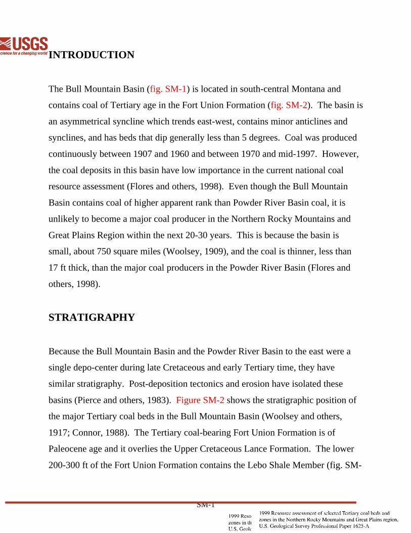
The Bull Mountain Basin (fig. SM-1) is located in south-central Montana and
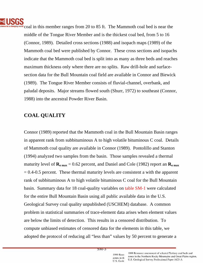
contains coal of Tertiary age in the Fort Union Formation (fig. SM-2). The basin is
an asymmetrical syncline which trends east-west, contains minor anticlines and
synclines, and has beds that dip generally less than 5 degrees. Coal was produced
continuously between 1907 and 1960 and between 1970 and mid-1997. However,
the coal deposits in this basin have low importance in the current national coal
resource assessment (Flores and others, 1998). Even though the Bull Mountain
Basin contains coal of higher apparent rank than Powder River Basin coal, it is
unlikely to become a major coal producer in the Northern Rocky Mountains and
Great Plains Region within the next 20-30 years. This is because the basin is
small, about 750 square miles (Woolsey, 1909), and the coal is thinner, less than
17 ft thick, than the major coal producers in the Powder River Basin (Flores and
others, 1998).
STRATIGRAPHY
Because the Bull Mountain Basin and the Powder River Basin to the east were a
single depo-center during late Cretaceous and early Tertiary time, they have
similar stratigraphy. Post-deposition tectonics and erosion have isolated these
basins (Pierce and others, 1983). Figure SM-2 shows the stratigraphic position of
the major Tertiary coal beds in the Bull Mountain Basin (Woolsey and others,
1917; Connor, 1988). The Tertiary coal-bearing Fort Union Formation is of
Paleocene age and it overlies the Upper Cretaceous Lance Formation. The lower
200-300 ft of the Fort Union Formation contains the Lebo Shale Member (fig. SM-

SM-2
2). The Tullock Member of the Fort Union Formation, which underlies the Lebo
Shale Member to the east in the Powder River Basin, is not recognized in the Bull
Mountain Basin. Woolsey and others (1917) reported that the Lebo Shale Member
contains one coal bed called the Big Dirty, which is as thick as 17 ft near the
middle of the member. The “upper part” of the Fort Union Formation, as defined
by Woolsey and others (1917), is called the Tongue River Member (Connor,
1989), is a minimum of 1,650 ft thick, and contains 26 coal beds that range in
thickness from 1 to 16 ft (fig. SM-2). The Fort Union Formation is overlain, in
part, by Quaternary river terrace gravels and sandy alluvium. These deposits are as
thick as 20 ft.
DESCRIPTION OF COAL
The Paleocene Fort Union Formation in the Bull Mountain Basin is considered a
minor coal-bearing formation. The 200-300-ft-thick Lebo Shale Member has been
described as the “somber-colored beds” by Richards (1910). Woolsey and others
(1917) report the Lebo Shale Member consists of olive-green, yellow, brown, and
dark-gray sandy-mudstone, sandstone, and coal. The only coal bed in the Lebo
Shale Member, the Big Dirty, is the thickest coal bed in the Bull Mountain Basin,
as much as 17 ft thick, but it is of no known economic interest because of the many
clastic partings and splits; hence its name. The Big Dirty coal bed was studied and
reported by Connor (1984). Connor notes that the numerous detrital layers in this
bed are crystal tuffs and altered volcanic ash, which indicate a period of intense
volcanism not recorded stratigraphically elsewhere in the Bull Mountain Basin.
The Tongue River Member of the Fort Union Formation, which ranges in thickness
from at least 1,650 ft to more than 2,050 ft, is composed of massive-yellowish to
buff sandstone, light- to dark-gray mudstone, and coal. Aggregate thickness of
SM-3
coal in this member ranges from 20 to 85 ft. The Mammoth coal bed is near the
middle of the Tongue River Member and is the thickest coal bed, from 5 to 16
(Connor, 1989). Detailed cross sections (1988) and isopach maps (1989) of the
Mammoth coal bed were published by Connor. These cross sections and isopachs
indicate that the Mammoth coal bed is split into as many as three beds and reaches
maximum thickness only where there are no splits. Raw drill-hole and surface-
section data for the Bull Mountain coal field are available in Connor and Biewick
(1989). The Tongue River Member consists of fluvial-channel, overbank, and
paludal deposits. Major streams flowed south (Shurr, 1972) to southeast (Connor,
1988) into the ancestral Powder River Basin.
COAL QUALITY
Connor (1989) reported that the Mammoth coal in the Bull Mountain Basin ranges
in apparent rank from subbituminous A to high volatile bituminous C coal. Details
of Mammoth coal quality are available in Connor (1989). Pontolillo and Stanton
(1994) analyzed two samples from the basin. Those samples revealed a thermal
maturity level of Ro max = 0.62 percent, and Daniel and Cole (1982) report an Ro max
= 0.4-0.5 percent. These thermal maturity levels are consistent a with the apparent
rank of subbituminous A to high volatile bituminous C coal for the Bull Mountain
basin. Summary data for 18 coal-quality variables on table SM-1 were calculated
for the entire Bull Mountain Basin using all public available data in the U.S.
Geological Survey coal quality unpublished (USCHEM) database. A common
problem in statistical summaries of trace-element data arises when element values
are below the limits of detection. This results in a censored distribution. To
compute unbiased estimates of censored data for the elements in this table, we
adopted the protocol of reducing all “less than” values by 50 percent to generate a

SM-4
pseudo value for these data. Summary statistics of range (minimum and maximum
value) and arithmetic means were generated using the modified data.
Between 1974 and 1994, the U.S. Geological Survey analyzed samples of coal for
contents of major-, minor-, and trace-elements. Prior to performing the analyses,
most of the coal samples were dried at room temperature and humidity for as much
as 80 hours. Some samples, however, may have only been dried enough to allow
grinding (to less than 100 mesh), and moisture contents of the samples are
unknown, although moisture contents were probably similar to that which would
remain after air-dry loss determination (American Society for Testing and
Materials ASTM Standards, 1994, D3302-91). Since the actual moisture content
of the samples analyzed between 1974 and 1994 is unknown, the elemental
analysis of the samples cannot be converted to any other moisture basis. In
addition, these analyses can only provide an approximation of load factors (such
as, pounds of mercury per trillion Btu).
RESOURCES
Connor (1989) estimated the resources for the Mammoth coal bed, following the
methodology of Wood and others (1983). The Mammoth coal bed contains 1,100
million short tons. Pierce and others (1983) estimated the resources of the
Mammoth coal bed at 1,120 million short tons using the Kriging method (Mousset-
Jones, 1980). Those are the only estimates available for the Bull Mountain Basin.

SM-5
The other 24 beds have not been considered a resource by previous workers,
although several of these beds have been mined.
PRODUCTION HISTORY
Coal has been mined commercially in the basin, but not continuously, since 1907
when the Republic Coal Company began operations on the Roundup coal bed (fig.
SM-2) near Roundup, Montana (fig. SM-1). Production prior to 1907 was limited
to a few tons per year, mined and utilized locally by the residents of the area for
heating and blacksmithing. Total production, from 1926 to 1960 (fig. SM-3), is
more than 23 million short tons (Montana Coal Council, written comun, 1998),
mainly from underground mines on the Roundup and McCleary coal beds. The
decision to mine these beds was probably influenced by proximity to rail
transportation. Production figures prior to 1926 are not available; there was no
commercial coal production during the 1960's. Coal production in the modern era
began in 1970 mainly from surface mines. Total production from 1970 to 1997
was 740 thousand short tons (fig. SM-4) (Resource Data International, Inc., 1998),
all from the Mammoth coal bed. The two production highs in 1990 and 1995 (fig.
SM-4) are due to the first underground mine producing coal from the Mammoth
coal bed.
CONCLUSIONS
Fort Union coal in the Bull Mountain Basin will not be a major source of coal in
the next two decades. Although the Mammoth coal bed has been mined in the past
and the quality (apparent rank, ash yield, and sulfur content, see table SM-1) is

SM-6
good, however, the small basinal area and thin beds indicate a low resource
potential. On a positive note, infrastructure for rail transport of coal is in place,
and if circumstances were good, minor amounts (minor when compared to
projected Powder River production; Flores and others, 1998) of coal could be
produced from the Bull Mountain Basin.

SM-7
REFERENCES CITED
American Society for Testing and Materials, 1994, Annual book of ASTM
Standards, Section 5, Petroleum products, lubricants and fossil fuels, Vol
05.05 Gaseous fuels; coal and coke; section D3302-91: American Society
for Testing and Materials, Philadelphia, Pennsylvania, p. 360-366.
Choate, R., Johnson, C.A., and McCord, J.P., 1984, Geologic overview, coal, and
potential for methane recovery from coalbeds–Powder River Basin, in
Rightmire, C.T., Eddy, G.E., and Kirr, J.N., eds., Coalbed methane resources
of the United States: American Association of Petroleum Geologists, Studies
in Geology v. 17., p. 135-162.
Connor, C.W., 1984, Ash-fall sequences in a Paleocene coal–potential indicator of
synchronicity between Montana and Wyoming basins, in Houghton, R.L.,
and Clausen, E.N., eds., 1984 Symposium on the geology of Rocky
Mountain coal: Bismark, N.D., North Dakota Geological Society,
Publication 84-1, p. 137-151.
1988, Maps showing outcrop, structure contours, cross sections, and isopachs
of partings–Mammoth coal bed, Paleocene Tongue River Member of the
Fort Union Formation, Bull Mountain coal field, south-central Montana:
U.S. Geological Survey Coal Investigations Map C-126-A, 2 sheets, scale
1:50,000.
1989, Maps showing coal-split boundaries, isopachs of coal splits, coal

SM-8
resources, and coal quality_Mammoth coal bed, Paleocene Tongue River
Member of the Fort Union Formation, Bull Mountain coal field, South-
Central Montana: U.S. Geological Survey Coal Investigations Map C-126-B,
2 sheets, scale 1:50,000.
Connor, C.W., and Biewick, L.R.H., 1989, Drill-hole and surface-section data, Fort
Union Formation, Bull Mountain coal field, south-central Montana–209
records as entered in the National Coal Resources Data System: U.S.
Geological Survey Open-File Report 89-6, 305 pages.
Daniel, J.A., and Cole, G.A., 1982, Petrography of the Mammoth coal seam, Bull
Mountain Basin, Musselshell County, Montana, in Gurgel, K.D., ed., Fifth
Symposium on the Geology of Rocky Mountain Coal, 1982: Utah
Geological and Mineral Survey Bulletin 118, p. 168-178.
Flores, R.M., Bader, L.R., Cavaroc, V.V., Ellis, M.S., Gunter, G.L., Johnson, L.C.,
Keighin, C.W., Likarish, D., Nichols, D.J., Ochs, A.M., Roberts, S.B.,
Stricker, G.D., Takahashi, K.I.,Taber, T.Y., Warwick, P.D., Govern, G., and
Murphy, E.C., 1998, Compilation of data on strippable Fort Union coals in
the Northern Rocky Mountains and Great Plains Region: Proceedings of the
23rd International technical conference on coal utilization and fuel systems,
Clearwater, Florida, March 9-13, 1998, p. 839-848.
Mousset-Jones, P.F., 1980, ed., Geostatistics, McGraw Hill, New York, 166 p.
Pierce, F.W., Grundy, W.D., Connor, C.W., and Marbeau, J.P., 1983,
Geostatistical study of three coal deposits in the western United States, in

SM-9
Wang, Y.J., and Sanford, R.L., eds., Proceedings, 1st Conference on use of
computers in the coal industry, Morgantown, West Virginia, August 1-3,
1983: New York, Society of Mining Engineers, of American Institute of
Mining, Metallurgical, and Petroleum Engineers, Inc., p. 359-373.
Pontolillo, James, and Stanton, R.W., 1994, Vitrinite reflectance variations in
Paleocene and Eocene coals of the Powder River, Williston, Hanna,
Bighorn, and Bull Mountain Basins, U.S.A., in Pontolillo, James, ed.,
Abstracts: Eleventh Annual Meeting of The Society for Organic Petrology,
Sept. 25-30, 1994, Jackson, Wyoming, p. 82-84.
Resource Data International, Inc., 1998, COALDAT database, version 4.1
(includes data current as of January, 1998): comprehensive dataset.
Software and database available from Resource Data International, Inc.,
1320 Pearl Street, Suite 300, Boulder, Colorado 80303.
Richards, R.W., 1910, The central part of the Bull Mountain coal field, Montana:
U.S. Geological Survey Bulletin 381, p. 60-81, 2 map plates.
Shurr, G.W., 1972, Paleocurrent indicators in Tongue River sandstones of the Bull
Mountain syncline, Montana, in Lynn, J., Balster, C.A., and Warne, J.R.,
eds., Crazy Mountain Basin, 21st Annual Geological Conference: Montana
Geological Society, p. 107-112.
Wood, G.H., Jr., Kehn, T.M., Carter, M.D., and Culbertson, W.C., 1983, Coal
resource classification system of the U.S. Geological Survey: U.S.
Geological Survey Circular 891, 65 p.

SM-10
Woolsey, L.H., 1909, The Bull Mountain coal field, Montana, in Cambell, M.R.,
ed., Contributions to Economic Geology, 1907, Part II--Coal and Lignite:
U.S. Geological Survey Bulletin 341, p. 62-77.
Woolsey, L.H., Richards, R.W., and Lupton, C.T., 1917, The Bull Mountain coal
field, Musselshell and Yellowstone Counties, Montana: U.S. Geological
Survey Bulletin 647, 218 p., 1 sheet, scale 1:125,000.

o o o
o
o
o
MONTANAWYOMING
Lewistown
Havre
Miles City
Jordan
Roundup Forsyth
Billings
BULL MOUNTAINBASIN
WILLISTON
BASIN
POWDER
RIVER
BASIN
K
K
K
K
K
T
T
T
T
T
110
48
46
108 106 104
0 50 MILES100
0 100 KILOMETERS
Figure SM-1. Location of the Bull Mountain Basin, south-central Montana.Bull Mountain Basin boundary drawn at the Lance-Fort Union boundary."K" denotes Cretaceous rocks and "T" denotes Tertiary rocks (from Connor, 1989).

SY
ST
EM
SE
RIE
SH
oloc
ene
Pal
eoce
ne
FO
RM
ATIO
NF
ort
Uni
on
ME
MB
ER
Tong
ue R
iver
Lebo
Sha
leLa
nce
(par
t)
QU
ATE
RN
AR
YT
ER
TIA
RY
CR
ETA
CE
OU
S(p
art)
COAL BEDTHICKNESS
OF COALBEDS (in feet)
THICKNESS(in feet)
0-20
890-1,210
200-300
700-800
765 - 845+ +
Unnamed coal
Bull Mountain
Rock Mesa
Mammoth
Dougherty
Buckley
WildhorseRoundupMcClearyCarpenter
Big Dirty
Rehder split
SummitFatig
3-7
33-4
2.5-6.5
2-7.50-5.55-16
1.5-5
0-6
0-60-80-8
2-17
0-3
Figure SM-2. Generalized stratigraphy with principal coal beds in the Bull Mountain Basin, southeastern Montana (modified from Woolsey and others, 1917; Connor, 1989).

196019551950194519401935193019250
200
400
600
800
1,000
1,200T
HO
US
AN
DS
OF
SH
OR
T T
ON
S
YEAR
Figure SM-3. Coal production for the years 1926–1960, Bull Mountain Basin, Montana.Data from the Montana Coal Council (1998).

19951990198519801975197019700
50
100
150
200T
HO
US
AN
DS
OF
SH
OR
T T
ON
S
YEAR
Figure SM-4. Coal production for the years 1970–1997, Bull Mountain Basin, Montana. Data from Resource Data International, Inc. (1998). Note change in vertical scale from that in figure SM-3.

Table SM-1. Summary of coal quality for all coal in the Bull Mountain Basin,
Montana. Calculated from the unpublished U.S. Geological Survey coal quality
database (USCHEM), February, 1992 and Connor (1989)
Variable Number Range Mean
of samples Minimum Maximum
Moisture 1 12 9.6 32.00 17.21Ash 1 12 5.60 10.40 8.32Total sulfur 1 12 0.50 1.20 0.82Calorific value 2 12 5,760 10,990 9,760lb SO2
3 12 1.09 2.46 1.70MMMFBtu 4 12 6,400 12,160 10,730Antimony 5 9 0.37 9.1 1.7Arsenic 5 9 1.0 35 7.0Beryllium 5 11 0.42 1.9 0.73Cadmium 5 12 0.066L 0.18 0.077Chromium 5 9 2.6 6.5 3.6Cobalt 5 9 0.65 5.5 1.4Lead 5 12 2.3L 34 6.7Manganese 5 12 8.3 130 41Mercury 5 12 0.040 0.28 0.11Nickel 5 12 0.66 9.0 2.7Selenium 5 7 0.48 0.98 0.75Uranium 5 12 1.1 6.8 1.8
1 Value is in percent and on an as-received basis.2 Value is in British thermal units (Btu).3 Value is in pounds per million Btu and on an as-received basis.4 Value is in British thermal units on a moist, mineral-matter-free basis.5 Value is in parts per million (ppm) on a whole-coal and as-received basis; AL@ denotes less than value shown.


