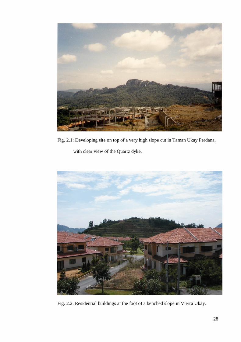
27 CHAPTER TWO 2.0 ENVIRONMENTAL SETTING OF THE STUDY AREA 2.1 Location and accessibility The study area is located in the Ulu Kelang District of Selangor Darul Ehsan State and includes the housing areas of Taman Ukay Perdana, Vierra Ukay, and Sierra Ukay (Fig. 2.1 and Fig. 2.2). Ulu Kelang, which is, geographically located at the latitude of 30 12’ 00” North and 10 10 46’01” longitude is under the jurisdiction of Ampang Jaya Municipality and Kajang Public Works Department. It is situated in the eastern part of the Ulu Kelang District and is bounded to the west by Setapak and to the south by Ampang. Jalan Ukay Perdana is the major road in the study area with other metalled roads being feeder roads (Fig. 2.3). Traverses in the study area were accomplished on foot along existing network of roads and foot paths. The main problems encountered in the course of traversing were the thick vegetation cover and inaccessibility to the upper portions of some of the very high cuts.
Transcript
27
CHAPTER TWO
2.0 ENVIRONMENTAL SETTING OF THE STUDY AREA 2.1 Location and accessibility
The study area is located in the Ulu Kelang District of Selangor Darul Ehsan State
and includes the housing areas of Taman Ukay Perdana, Vierra Ukay, and Sierra Ukay
(Fig. 2.1 and Fig. 2.2). Ulu Kelang, which is, geographically located at the latitude of
30 12’ 00” North and 10 10 46’01” longitude is under the jurisdiction of Ampang Jaya
Municipality and Kajang Public Works Department. It is situated in the eastern part of
the Ulu Kelang District and is bounded to the west by Setapak and to the south by
Ampang. Jalan Ukay Perdana is the major road in the study area with other metalled
roads being feeder roads (Fig. 2.3). Traverses in the study area were accomplished on
foot along existing network of roads and foot paths. The main problems encountered in
the course of traversing were the thick vegetation cover and inaccessibility to the upper
portions of some of the very high cuts.
28
Fig. 2.1: Developing site on top of a very high slope cut in Taman Ukay Perdana, with clear view of the Quartz dyke.
Fig. 2.2. Residential buildings at the foot of a benched slope in Vierra Ukay.
29
Fig 2.3. Location map of Ukay Perdana showing major and feeder roads.
30
2.2 Geomorphology (Relief and Scenery)
Geomorphology is concerned with the study of earth’s physical features or
landforms and their relationship with the underlying geological structure and lithology
(Moore, 1978). Geomorphologically, the Ukay Perdana area is one of variable relief
with several steep-sided hills separated by V-shaped valleys (Fig. 2.4); the variable
relief resulting from varying degrees of resistance to weathering and erosion of the
underlying bedrock. Development of the area for housing purposes furthermore, has
drastically distorted this past topography and has led to the excavation of slope cuts for
the construction of roads within the area. Presently, the topography of Ukay Perdana is
characterized by steep valley walls and numerous uplands covered mostly by grasses
and shrubs, and the area lies at an average elevation of some 50 meters to 160 meters.
The influence of rock types and their distributions in this region gave rise to dendritic
drainage system. Trees towering above 80m are very sparse. The uplands harbour many
residential houses and in most cases along slope angles with many cases of minor
failures (Fig.2.5).
31
Fig. 2.4: Steep sided hills separated by V-shaped valleys.
Fig. 2.5. Residential houses along steep slope angles.
32
2.3 Climate 2.3.1 Climate and vegetation
The study area has a humid tropical climate that has resulted in the development
of a dense vegetation cover in places. According to Iloeje (1981), vegetation is the
plant cover at the earth`s surface and includes trees and grasses of different kinds, some
of which are natural and others planted by man. Both natural and man-influenced
vegetation abound in the study area with the natural vegetation being in the form of a
thick canopy of foliage, which is only broken where there are rock outcrops (Fig.2.6) or
where there are clearings as a result of human activities.
The vegetation has three distinctive levels; ground level, middle level, and highest
level.
Ground Level: This level includes herbs, shrubs, and some grasses with maximum
height in the range of 2 meters to 6 meters. This level is only dense where tall trees
have been cleared.
Middle Level: The middle level comprises trees towering between 10 meters and 24
meters in height. There are robust branches and a dense, dark green foliage. The
intertwining of branches creates an almost continuous canopy of leaves which shut off
sunlight from the ground level.
Highest Level: This level comprises trees that stand out above the surrounding like
ocean of densely packed vegetation with heights exceeding 50 meters.
33
34
2.3.2 Temperature and rainfall
Temperature and rainfall recording stations closest to the study area are located at
Empangan Genting Klang, and Ibu Bekalan kilometer 11 at Gombak. The temperature
records show that temperature does not fluctuate much during the year with an average
temperature between 21 and 32 degrees Celcius. The temperature records also show
April and May as the months with the highest average monthly temperatures, whilst
December and January are the months with the lowest average monthly temperatures
(DID, 2008).
Monthly rainfall records for year 2007 compiled from the two rainfall recording
stations show that there are two periods of maximum rainfall separated by two periods
of minimum rainfall. The primary maximum rainfall generally occurs in September -
November while the secondary maximum occurs in March –July, with June being the
highest month of rainfall. The annual rainfall averages more than 2500mm. The
histograms for the monthly rainfall frequencies of both stations are shown in Fig. 2.7
and Fig. 2.8 based on Table 2.1 and Table 2.2 respectively. Relative humidity in the
study area is normally about 88% in November and falls to a low of 84% in February
(DID, 2008).
35
Fig. 2.7: Monthly rainfall for year 2007 at site 3217002 in Empangan Genting
Klang in Wilayah Persekutuan.
Fig. 2.8: Histogram of year 2007 Monthly Rainfal at site 3217003 in Ibu Bekalan
KM.11 at Gombak, Wilayah Persekutuan.
36
Months Rainfall (mm)
January 104.5
February 98
March 188.5
April 248
May 158
June 457
July 171.5
August 98
September 247.5
October 332.5
November 226
December 129.5
Total 2459.0
Table 2.1: Year 2007 Monthly rainfall data, site 3217002 in Empangan Genting
Klang, W. Persekutuan (DID, 2008).
37
Months Rainfall (mm)
January 132
February 111.5
March 284
April 214
May 119
June 401
July 340.5
August 78.5
September 393
October 361.5
November 281
December 145.5
Total 2861.5
Table 2.2: Year 2007 Monthly rainfall data, site 3217003 in Ibu Bekalan KM.11 at
Gombak, W. Persekutuan, (DID,2008).
38
2.4 Geology of Kuala Lumpur
It is generally accepted that Peninsular Malaysia is divided into Western Belt,
Central Belt, and Eastern Belt (Fig. 2.11) but the exact boundaries are different among
various authors (Hutchinson, 1977; Tjia, 1987; and Abdullah, 2006). The Kuala Lumpur
area occurs within the Western Belt of Tjia (1999) which has sedimentary and volcanic
rocks of Cambrian to Triassic age and younger Upper Mesozoic continental red-beds,
Tertiary lacustrine-fluviatile deposits and widespread Quaternary alluvium is also found
(Khoo, 1994). The study area of Ukay Perdana is located within the Kuala Lumpur area
(Fig. 2.9).
Gobbet (1965) mapped the Kuala Lumpur area and differentiated four separate
units of Lower and Upper Paleozoic rocks, i.e. the Dinding Schist which is conformably
overlain by the Hawthornden Schist which in turn overlain by the Kuala Lumpur
Limestone. These rocks are of a Lower Paleozoic age, with the Kuala Lumpur
Limestone unconformably overlain by the Kenny Hill Formation.
39
Fig 2.9. Map of Peninsular Malaysia showing study area.
40
2.4.1 Dinding schist
This unit is named after its outcrop in the Bukit Dinding area of Ulu Kelang
District. The area of outcrop extends from Zoo Negara (National Zoo) through the
Kemensah, Taman Melawati, AU3 Keramat, AU4 Lembah Keramat and Wangsa Maju
areas into Taman Ukay Perdana. Khoo (1994) has stated that the rock types in the
Dinding schist are quartz-biotite-muscovite schist, quartz schist, and meta-volcanic
rocks. Virtually all the rocks in the Dinding schist outcrop area have been contact
metamorphosed and thus has led to the development of biotite in particular by contact
metamorphism of low grade regionally metamorphosed schistose rocks devoid of biotite
(Khoo, 1994). The Dinding schist has been estimated by Gobbert (1965) to have a
thickness exceeding 3,350 m. No earlier, or later, worker has, however, confirmed this.
The fossiliferous Kuala Lumpur limestone, from its stratigraphic position is the most
reasonable reference of interpretation for the age of the Dinding schist. Khoo (1994)
thus has proposed that the Dinding schist is older than the Middle Silurian, and perhaps
Ordovician .
2.4.2 Hawthornden schist
This rock unit overlies the Dinding schist and is a mainly graphitic schist which
derives its name from its outcrop in Hawthornden Estate. Khoo (1994) has extensively
studied the Hawthornden schist in its’ type locality and noted the predominance of black
graphitic schist. Good exposures of the Hawthornden schist are presently found at
Wangsa Maju, Setia Wangsa and Taman Melati. Quartz veins and pyrite are seen in
some exposures, with Khoo (1994) reporting the pyrites to occur as individual cubes
evenly spread across, or as fine grained lenticluar bodies and pods concordant with the
foliation. The Hawthornden schist comprises some 900m of unfossiliferous
41
carbonaceous schists and phyllites that pass conformably up into the overlying Upper
Silurian Kuala Lumpur limestone (Jones, 1968 in Gobbert and Hutchison, 1973). The
Hawthornden schist would therefore, appear to be Lower Silurian in age and may
represent the southerly continuation of the Mahang Basin sediments of Kedah.
2.4.3 Kuala Lumpur limestone
The Hawthornden schist is conformably overlain by the Kuala Lumpur limestone,
which is a remarkably pure marble. This rock is essentially marble, but locally it is a
dolostone, massive and inter-foliated with calcite marble. Occasionally, tremolite and
brucite occur in the Ampang area; periclase and brucite are common minerals in the
metamorphosed dolomite (Hutchison,1968).
The Kuala Lumpur limestone has a crescent shaped outcrop area extending from
the northwest to the southeast of the city. The strata, however, are only exposed at the
surface in the north end of Kuala Lumpur where they give rise to the spectacular Batu
Caves. The Kuala Lumpur limestone is made up predominantly of coarse, white to
grey, marble. Grain boundary alterations during metamorphic recrystallization have
reduced minor dark bands into finer grained layers. Gobbet (1965) has noted that the
Kuala Lumpur limestone is mainly of a calcitic composition, with minor inter-beds of
magnesian and dolomitic limestone as well as thin inter-beds of chlorite schist.
Thomas (1963) and Boucot et al (1966) have discussed the fossil composition of
the Kuala Lumpur limestone and noted that it is richly fossiliferous at certain horizons,
containing corals, brachiopods, gastropods, and crinoids. Corals identified include
ketaphyllum aff. Turbinatum, Heliolites aff. Barrandei var. sponges, Favosites sp.,
42
Thecia swinderniana and Halysites sp. Brachiopods found include Dalmanella,
Capellinella, Cymbidium, Atrypella and Delthyris, while the gastropods discovered
include Poleumita cf. discors, Poleumita scamnata, Euomphalus sp. and Laxonoma sp.
Gobbet (1965) estimated the thickness of the Kuala Lumpur limestone to be 1830m
while the age was determined as Upper Silurian based on the fossil content.
2.4.4 Kenny hill formation
This formation of clastic sediments outcrops in most parts of south and southwest
Kuala Lumpur and extends into the suburbs of Petaling and Petaling Jaya. The
Formation unconformably overlies the Kuala Lumpur limestone and is best exposed in
the Bukit Tunku area (formerly known as Kenny Hill) from which it derived its name.
The Kenny hill formation comprises a monotonous inter-bedded sequence of
shales, mudstones and sandstones. New outcrops are found at Pantai Dalam, Pantai
Hill, Damansara and Puchong. Primary structures associated with this unit include a
distinctive assemblage of graded bedding, soft-sediment deformation and organic tubes
and burrows (Stauffer, 1968).
The age of the Kenny hill formation has been deduced from organic tubes and
burrows and poorly preserved impressions based on paleontology. Stauffer (1968) fixed
the age of this unit as Upper Paleozoic based on correlation with other rock units. The
formation has also been said to be in the upper part of the Lower Permian based on a
report that rocks of a similar lithology in the Kinta Valley might be of the same age as
the H.S. Lee Beds in Kampar, Perak which contain Misellina claudiae and Agathiceras
sp. The discovery of this Permian ammonoid (Agathiceras sp.) in beds of Kenny hill
43
formation in the Sepang area further suggests the age of Kenny hill formation to be
Early to Middle Permian providing the first reliable age based on fossils, although
Agathiceras has a full range of Late Carboniferous to about Middle Permian
(Geological Survey of Malaysia Annual Report, 1985 and 1989). It is, however, certain
that the Kenny hill formation is younger than the Kuala Lumpur limestone but older
than the granitic rocks and tin lodes. There have been varied estimates of the thickness
of this rock unit by different authors. Yin cited in Stauffer (1973) estimated the
thickness to be about 300m while Choy (1970) and Yeap (1970) estimated the thickness
of the unit to be between 1,200m and 1,500m based on attitude of the syncline.
44
2.5 Geology of study area
The study area Ukay Perdana in Ulu Kelang area (Fig. 2.10) is located within the
outcrop area of the Lower Palaeozoic rocks of the Dinding schist, comprising mainly
quartz-mica schists. In some areas, however, there are granite vein intrusions into the
Dinding schist (Fig. 2.11). This is evidence of a subsequent phase of granite intrusion
and likely contact metamorphism. The schist ranges from unweathered exposed
bedrocks to slightly weathered, moderately weathered, and highly weathered still
retaining some of its original structural features. Study of the Dinding schist carried out
by Wong (1980) in Kepong and surrounding areas also attests to the quartz-mica
composition of the schist though he carried out the petrographic analysis on fresh
boulders found in stream as most outcrops in the area are highly weathered.
45
Fig. 2.10: Geological setting of Ulu Kelang area (Gobbett, 1964; Yin, 1974).
46
Fig. 2.11: Pronounced sub-parallel granite intrusion into the dinding schist in Taman Ukay Perdana.