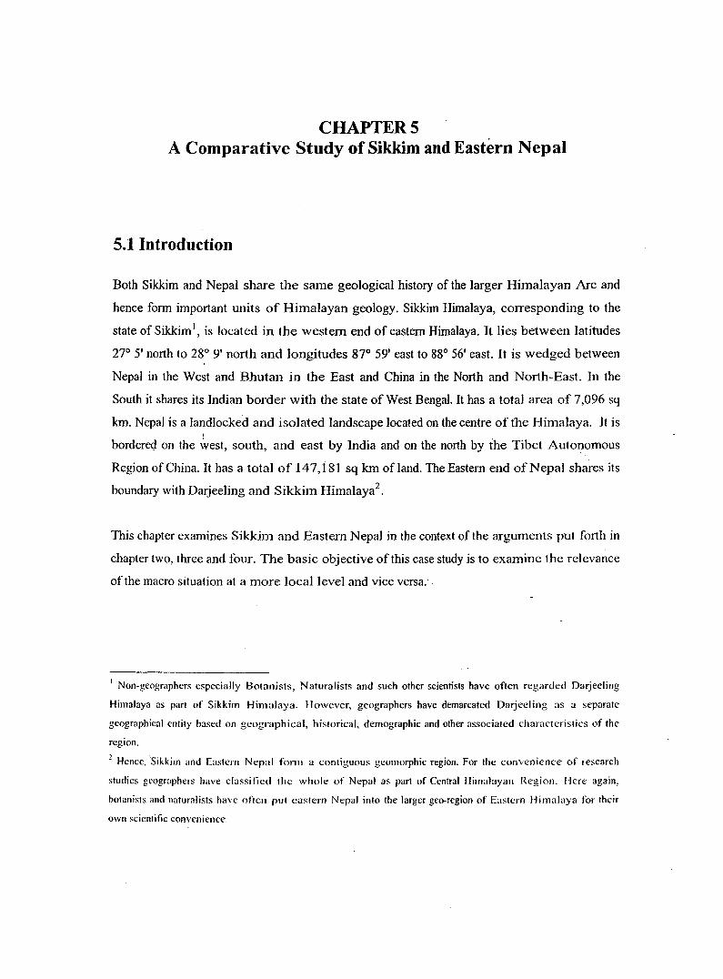
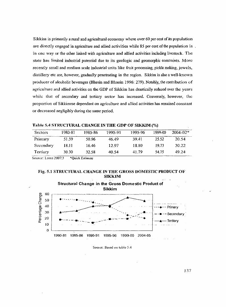
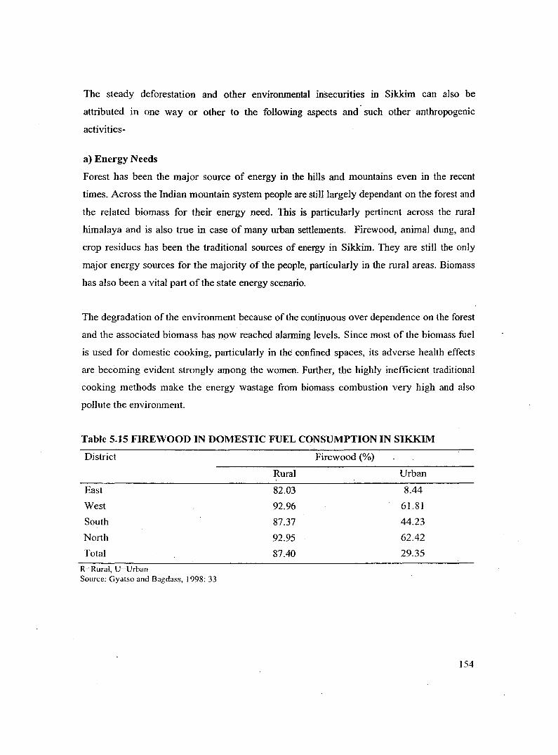
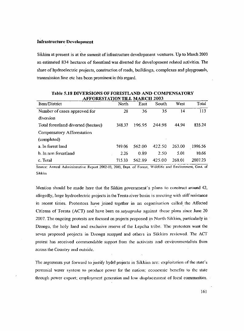
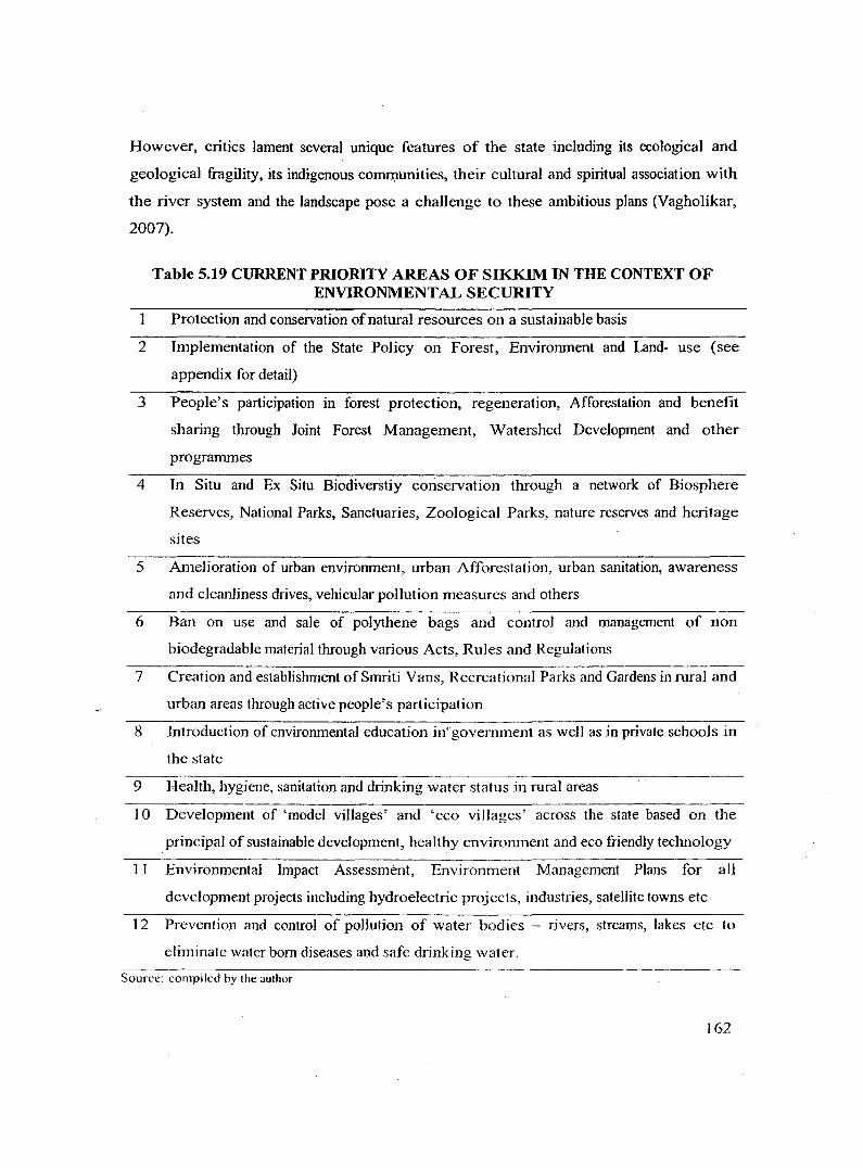
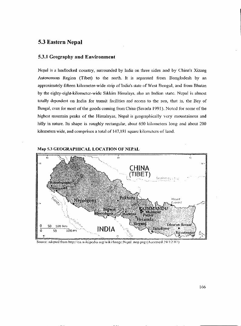
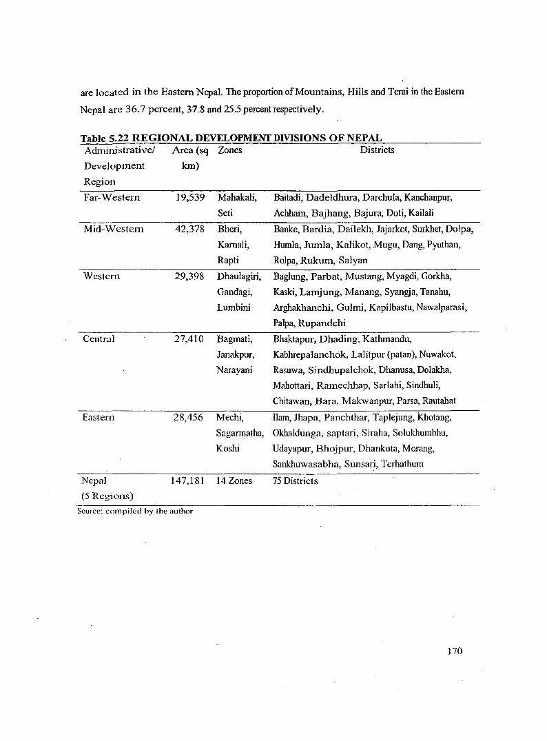
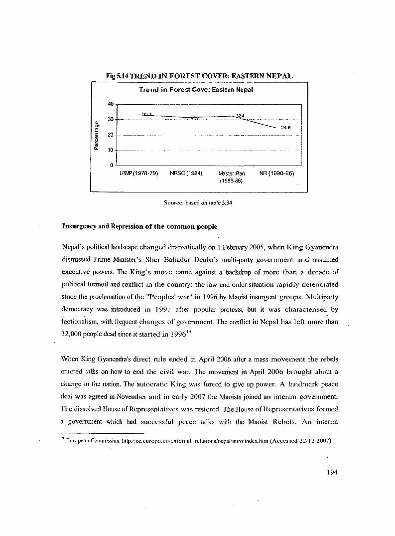
CHAPTERS A Comparative Study of Sikkim and Eastern Nepal 5.1 Introduction Both Sikkim and Nepal share the same geological history of the larger Himalayan Arc and hence form important units of Himalayan geology. Sikkim Himalaya, corresponding to the state of Sikkim 1 , is located in the western end of eastern Himalaya. It lies between latitudes 27° 5' north to 28° 9' north and longitudes 87° 59' east to 88° 56' east. It is wedged between Nepal in the West and Bhutan in the East and China in the North and North-East. In the South it shares its Indian border with the state of West Bengal. It has a total area of 7,096 sq km. Nepal is a landlocked and isolated landscape located on the centre of the Himalaya. It is ' on the west, south, and east by India and onthe north by the Tibet Autonomous Region of China. It has a total of 147,181 sq krn of land. The Eastern end of Nepal shares its boundary with Dmjeeling and Sikkim Himalaya 2 • This chapter examines Sikkim and Eastern Nepal in the context of the arguments put forth in chapter two, three and four. The basic objective of this case study is to examine the relevance of the macro situation at a more local level and vice versa .. 1 Non-geographers especially Botanists, Naturalists and such other scientists have often regarded Darjccling Himalaya as part of Sikkim Himalaya. However, geographers have demarcated Darjecling as a separ.Jte geographical entity based on geog.-aphical, historical. demographic and other associated characteristics of the region. 1 Hence, ·Sikkim and Eastern Nepal form a contiguous geomorphic region. For the convenience of research studies geographers have classified the whole of Nepal as part of Central Himalayan Region. Here again, botanists and naturalists have often put eastern Nepal into the larger geo-region of Eastem Himalaya for their own scientific convenience.
Transcript
CHAPTERS A Comparative Study of Sikkim and Eastern Nepal
5.1 Introduction
Both Sikkim and Nepal share the same geological history of the larger Himalayan Arc and
hence form important units of Himalayan geology. Sikkim Himalaya, corresponding to the
state of Sikkim 1, is located in the western end of eastern Himalaya. It lies between latitudes
27° 5' north to 28° 9' north and longitudes 87° 59' east to 88° 56' east. It is wedged between
Nepal in the West and Bhutan in the East and China in the North and North-East. In the
South it shares its Indian border with the state of West Bengal. It has a total area of 7,096 sq
km. Nepal is a landlocked and isolated landscape located on the centre of the Himalaya. It is '
bordere~ on the west, south, and east by India and onthe north by the Tibet Autonomous
Region of China. It has a total of 147,181 sq krn of land. The Eastern end of Nepal shares its
boundary with Dmjeeling and Sikkim Himalaya2•
This chapter examines Sikkim and Eastern Nepal in the context of the arguments put forth in
chapter two, three and four. The basic objective of this case study is to examine the relevance
of the macro situation at a more local level and vice versa ..
1 Non-geographers especially Botanists, Naturalists and such other scientists have often regarded Darjccling
Himalaya as part of Sikkim Himalaya. However, geographers have demarcated Darjecling as a separ.Jte
geographical entity based on geog.-aphical, historical. demographic and other associated characteristics of the
region. 1 Hence, ·Sikkim and Eastern Nepal form a contiguous geomorphic region. For the convenience of research
studies geographers have classified the whole of Nepal as part of Central Himalayan Region. Here again,
botanists and naturalists have often put eastern Nepal into the larger geo-region of Eastem Himalaya for their
own scientific convenience.
Map 5.1 GEOGRAPHICAL LOCATIONS OF SIKKIM AND EASTERN NEPAL
so· 82" 84" 86" as·
30" 30"
28" 28"
26" 26"
so· 82" 84" 86" 88"
130
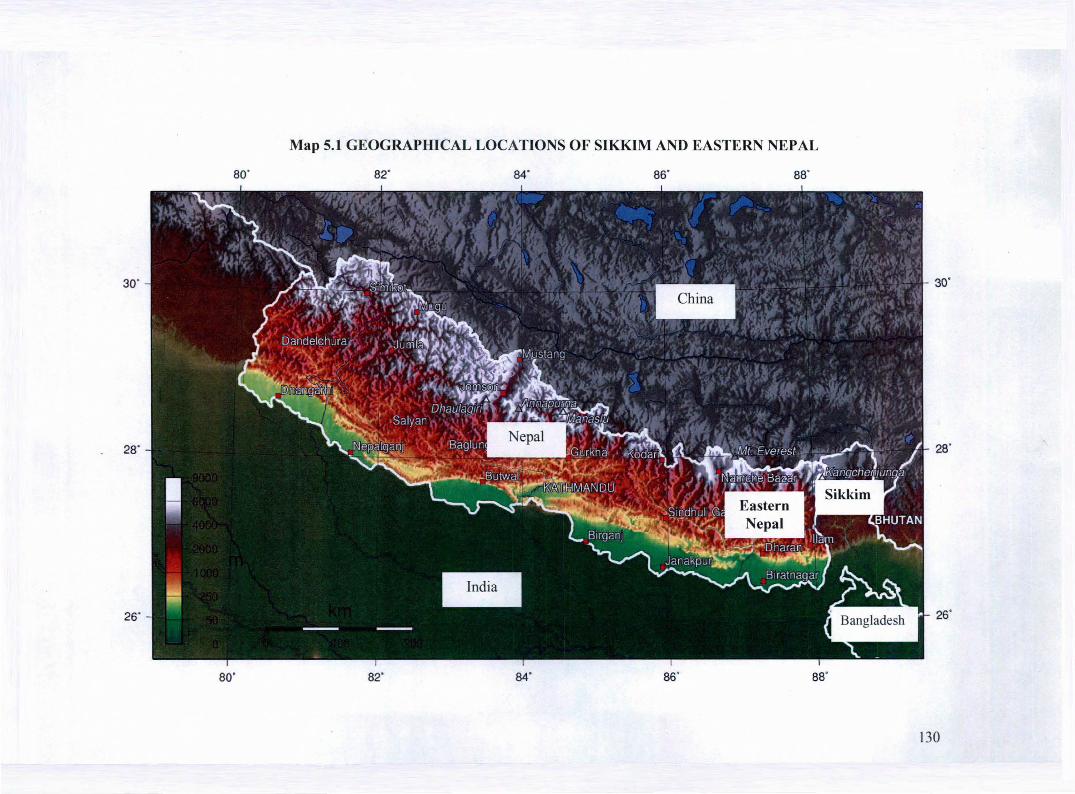
5.2 Sikkim Himalaya
5.2.1 Geography and Environment
Sikkim forms a part of both Lesser and Great Himalayan ranges and geographically it shares
an important portion of the Eastern Himalaya. Covering just 0.2 percent of the country the
Sikkim Himalaya is characterized with formidable physical features. It presents a compound
landscape because the complexity of geomorphic evolution has played an important role in
the development of the existing topography. Starting at the foot with a meager elevation of
less than 300 meters it stretches up to as high as 8550 meters above the mean sea level. The
hills rise abruptly from the plains and the elevation increases northward and northwestward.
The third highest mountain ridge Mt. Kanchenjunga (8598 m) and other high elevations are
located in the northwestern part of the system.
It encloses within its borders a variety of geographic environments starting from lower snow
free hills to the high peaks with permanent snow and glaciers (table 5.1). The highest portion
of Sikkim lies in its North-West direction. A large number of mountains having altitudes of
about seven thousand meters stand here with Mount Kanchendzonga (8598m). A number of
glaciers descend from eastern slopes of Kanchendzonga into Sikkim. The biggest of them is
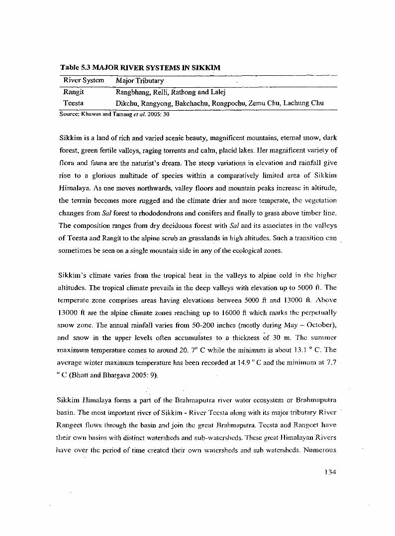
Zemu, from whose snout, above Achen monastery, originates the river Teesta. Two principal
mountain ranges of Sikkim are the Singilela3 and Chola. They start in the north and continue
· more or less southerly direction. Between these ranges are the Principle Rivers, the Teesta
and Rangit, forming the main channels of drainage. These rivers are fed by the monsoon as
well as by melting glaciers.
3 This is the range that separates Sikkim with (Ea~tem) Nepal.
131
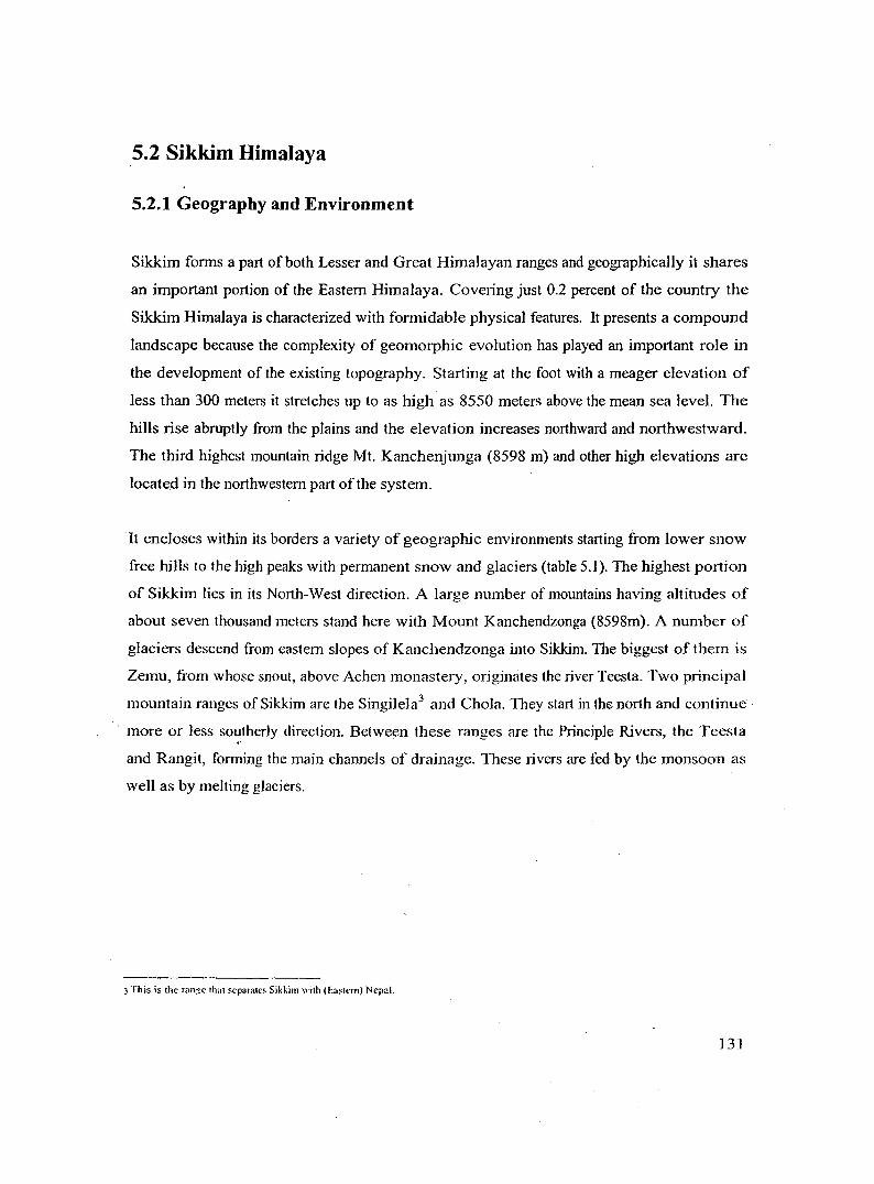
Map 5.2 ADMINISTRATIVE DIVISION OF SIKKIM
N China
r China
Nepal
Bhutan
Nor ro Scale
132
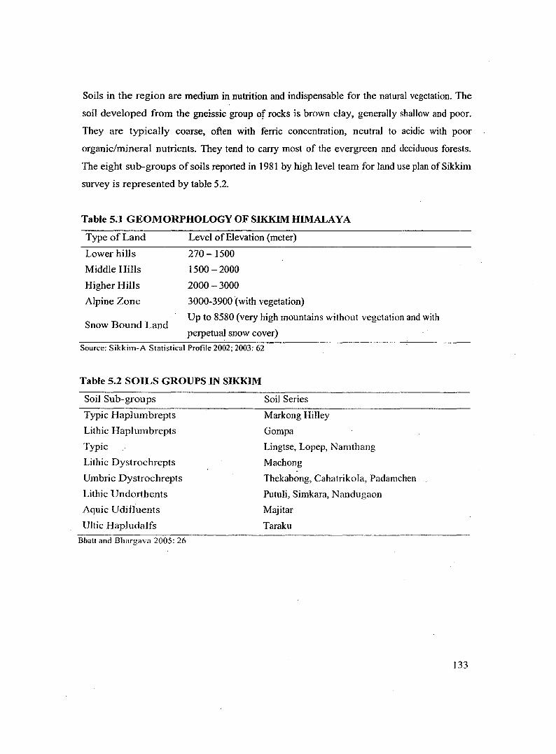
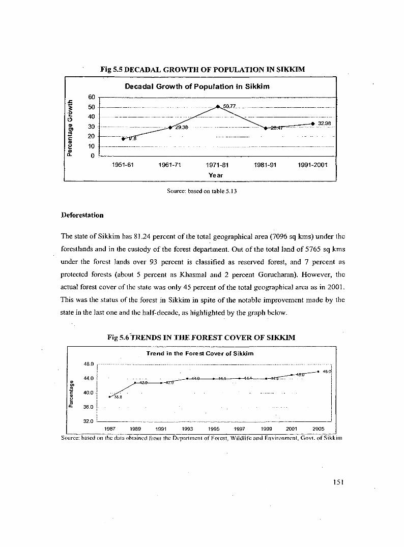
Soils in the region are medium in nutrition and indispensable for the natural vegetation. The
soil developed from the gneissic group of rocks is brown clay, genera11y sha11ow and poor.
They are typically coarse, often with ferric concentration, neutral to acidic with poor
organic/mineral nutrients. They tend to carry most of the evergreen and deciduous forests.
The eight sub-groups of soils reported in 1981 by high level team for land use plan ofSikkim
survey is represented by table 5.2.
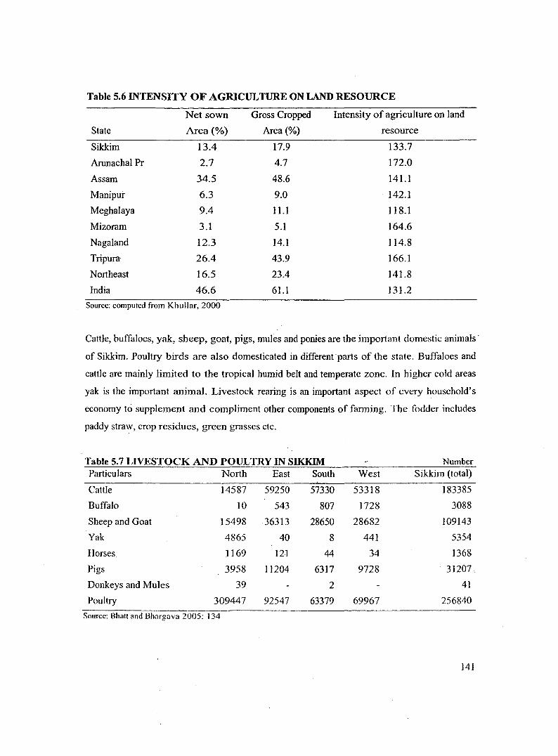
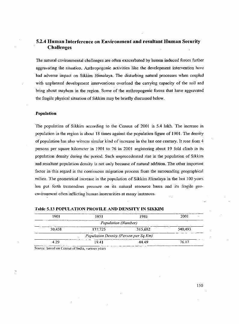
Table 5.1 GEOMORPHOLOGY OF SIKKIM HIMALAYA
TypeofLand
Lower hills
Middle Hills
Higher Hills
Alpine Zone
Snow Bound Land
Level ofElevation {meter)
270-1500
1500-2000
2000-3000
3000-3900 (with vegetation)
Up to 8580 {very high mountains without vegetation and with
A case from one of the villages of Western Sikkim would be relevant to depict the general
socio-economy of the region5: Suldung-Kamling is a Gram Panchayat unit in West Sikkim
district under Chakung constituency. Due to rain shadow of the Dmjeeling hills the area
receives scant rainfall with a long lean season of 3-4 months. The terrain is very steep with
the average slope being about 45 degrees, with some areas being still steeper. The soil in the
area is of two types: lateritic with better soil depth and sandy shal1ow soil. The vi11agers have
made a sustainable use of the limited resources they have. The steepest part of the fields are
planted with useful trees, moderately steep areas are planted with pulses and less steep and
5 Based on field visit.
143
terraced fields are used for cultivating maize and ginger. The main challenges provided by
nature are geographic wherein steep lands combined with scant rainfall reduce productivity.
Culturally, Rais, Lepchas, Chettri and Mangers dominate6 the landscape. The economy is
largely agrarian with ginger and pulses providing the main source of income. The total
absence of irrigation facility is the main bottleneck for sustainable farming. Incomes from
ginger have gone down drastically over the years due to reduced productivity. The
productivity has fallen from 4 -5 times to 2-3 times now. The main source of cash incomes is
from sale of ginger, pulses and from wage labour amounting to about Rs 1500 per month.
About 50 per cent of the income is used for buying rice while the remaining is used for
purchasing grocery, clothes etc. Amongst livestock poultry, goatery and cattle are reared in
limited numbers. Cattle are reared for manure, milk and for ploughing while chicken and
goat function as rural household banks, to be liquidated during times of need.
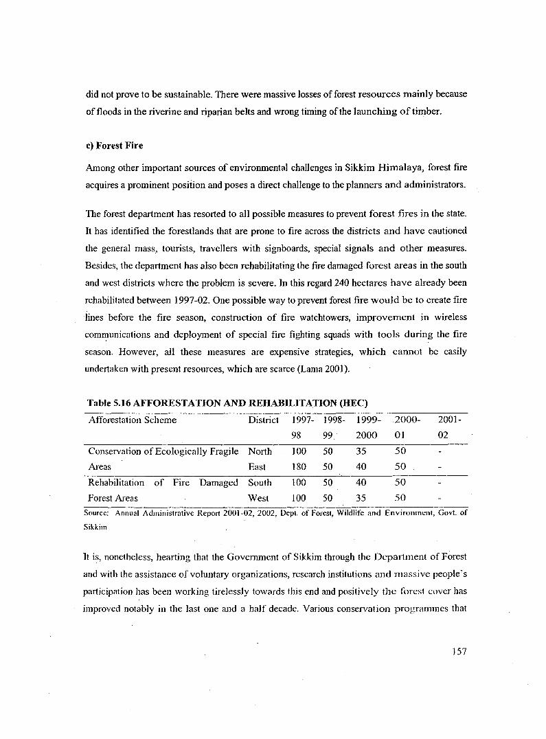
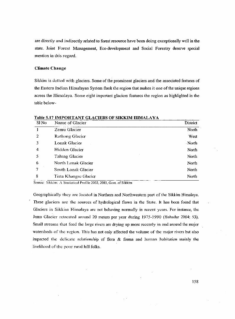
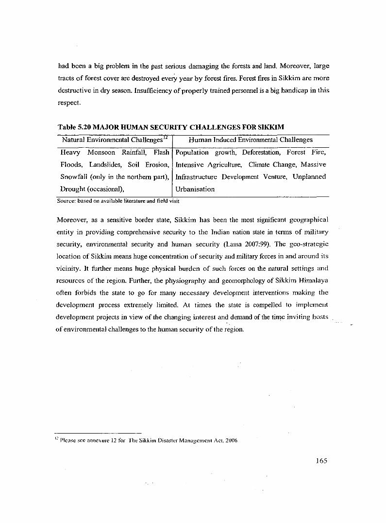
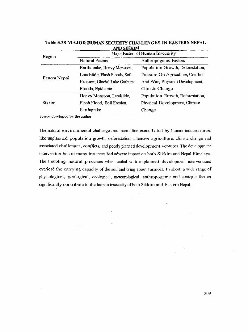
5.2.3 Natural Environmental Challenges
The entire Sikkim Himalaya is a part of the youngest and loftiest mountain system of the
world 'the Himalaya' and hence is characterized with highly folded and faulted rock strata at
many places. Being a part of the larger Himalayan Region, Sikkim is seismically sensitive
and threatened by a number of geo-environmental challenges. The rock type in the region
mainly consists of phyllites a11d schists and therefore the slopes are highly susceptible to
weathering, erosion, landslides and other forms of mass wasting. The high intensity of rain .. falling during monsoon in the state often causes extensive soil erosion and heavy losses of
nutrients from the land by leaching. Important physical challenges that often threaten human
security in Sikkim Himalaya may be listed and briefly discussed below.
Earthquake
While Sikkim has not witnessed any maJor earthquake events within its geographical
boundary in the recent history the possibility of such disaster cannot be ignored given the
history of earthquake happenings in the Himalayan Region.
6 All of which belong to the larger Nepali speaking community.
144
Heavy and Spontaneous Monsoon RainfaJI
Monsoon rainfall is greater in the Eastern Indian Himalaya than in its western counter part.
Within Eastern Himalaya again the rainfall is intense in Sikkim - Daijee]ing Himalaya. The
reason being: with the Rajmaha1 hi1ls situated to the west and the Shi11ong plateau to the east
there is no mountain range to protect the Teesta VaHey from the sweeping monsoon winds
rising from the Bay of Bengal. As a result the summer monsoon directly hits the foothi11s and
the Jesser Himalayan ranges of Dmjeeling and Sikkim and gives the Teesta Valley
exceedingly high burst of rainfall ranging between 3000 mm to 6000 mm every year (CSE
1991 ). In this connection, it is informative to highlight that India Meteorological Department
classifies rainfall (24 hours) in the following categories:
>65mm: > 85mm: > 250mm:
heavy, very heavy exceptiona1ly heavy precipitation
Soil Erosion, Landslides and Floods
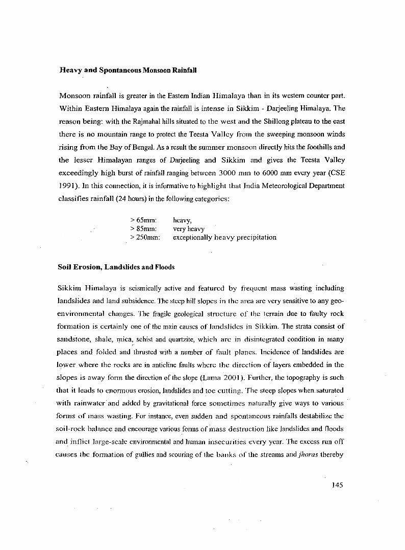
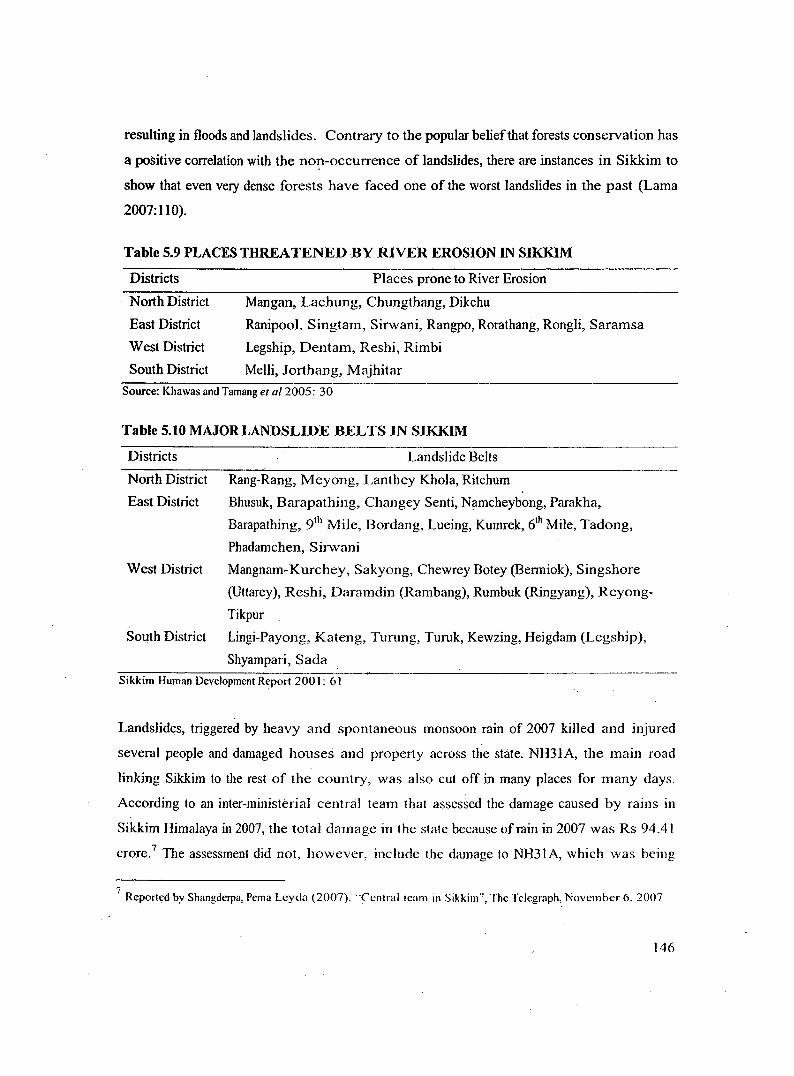
Sikkim Himalaya is seismically active and featured by frequent mass wasting inc1uding
landslides and land subsidence. The steep hill slopes in the area are very sensitive to any geo
environmental changes. The fragile geological structure of the terrain due to faulty rock
formation is certainly one of the main causes of landslides in Sikkim. The strata consist of
sandstone, shale, l)lica, schist and quartzite, which are in disintegrated condition in many
places and folded and thrusted with a number of fault planes. Incidence of landslides are
lower where the rocks are in anticline faults where the direction of ]ayers embedded in the
slopes is away form the direction of the slope (Lama 2001 ). Further, the topography is such
that it leads to enonnous erosion, landslides and toe cutting. The steep slopes when saturated
with rainwater and added by gravitational force sometimes naturally give ways to various
forms of mass wasting. For instance, even sudden and spontaneous rainfal1s destabilize the
soil-rock balance and encourage various forms of mass destmction like landslides and floods
and inflict large-scale environmental and human insecurities every year. The excess run off
causes the formation of gul1ies and scouring of the banks of the streams and jhoras thereby
145
resulting in floods and landslides. Contrary to the popular belief that forests conservation has
a positive correlation with the no~-occurrence of landslides, there are instances in Sikkim to
show that even very dense forests have faced one of the worst landslides in the past (Lama
2007:110).
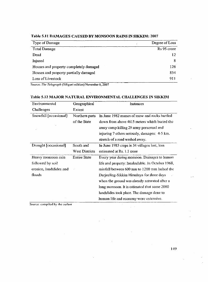
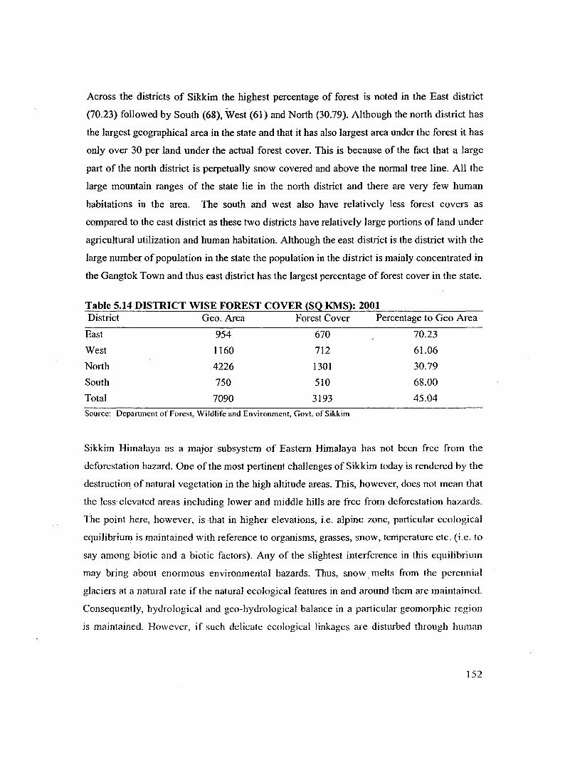
Table 5.9 PLACES THREATENED BY RIVER EROSION IN SIKKIM
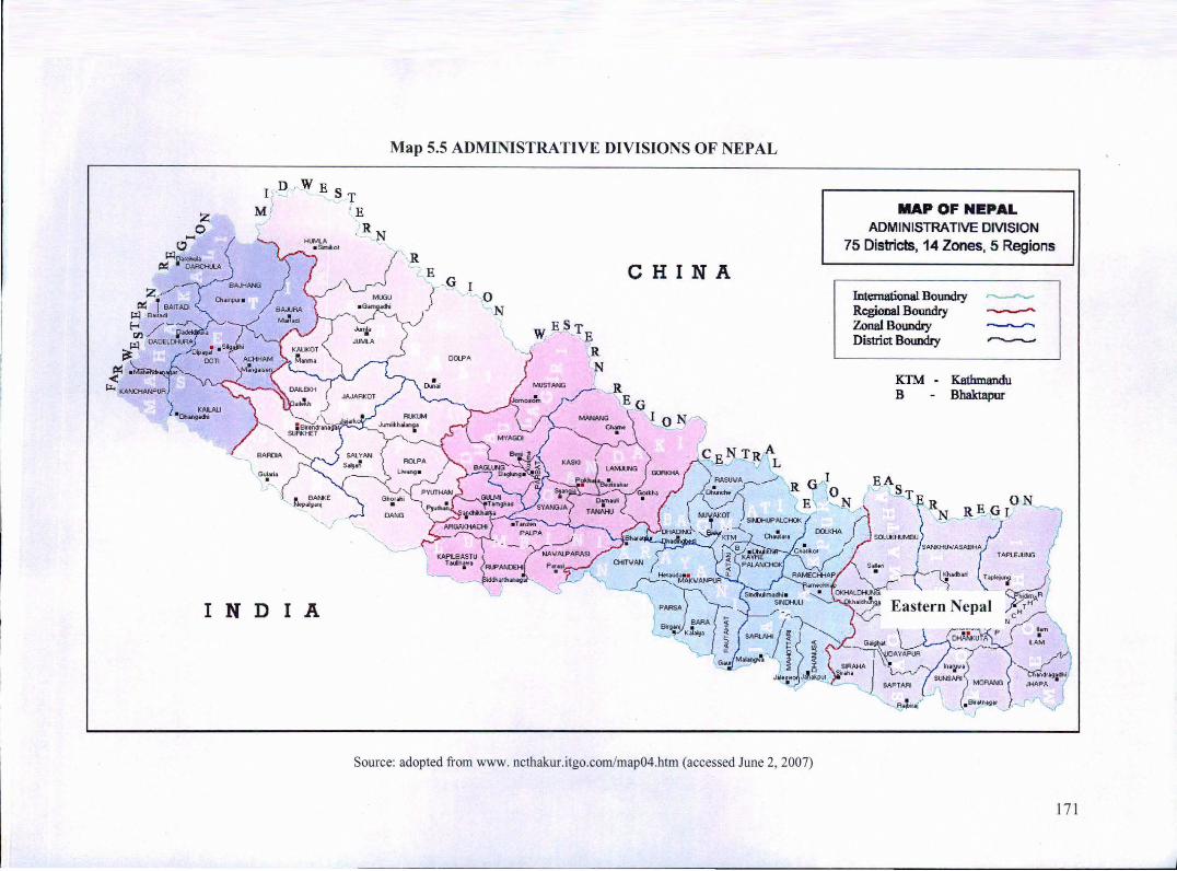
Source: adopted from www. ncthakur.itgo.com/map04.htm (accessed June 2, 2007)
MAP OF NEPAL ADMINISTRATIVE DIVISION
75 Districts, 14 Zones, 5 Regions
Intemational Boundry ,....,__,._ Regional Boundry ~ Zonal Boundry w
District Boundry ,.......____,
KTM • Kathmandu B Bhaktapur
171
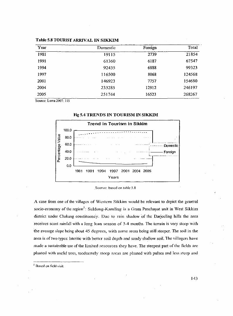
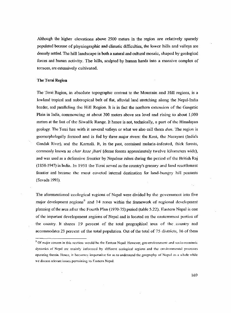
Fig 5.8 SHARES OF PHYSIOGRAPIDC REGIONS IN EASTERN NEPAL
Share of Physiographic Regions in Eastern Nepal
40
Cl> 30 C) ., c 20 Cl> ~ Cl>
10 0..
0 l'vbuntain HiRs Terai
Source: based on table 5.22
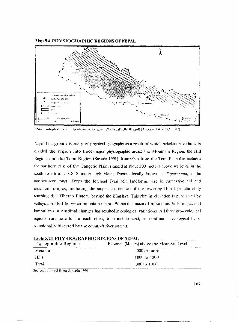
As a consequence of immense physiographic, geographic and geomorphic diversity, Nepal
has a great deal of variation in its climatic pattern. The Tarai Region is featured by a tropical
and subtropical climatic regime. Beyond the Terai, however, the climate is completely
different. Such extraordinary differences in climatic conditions are primarily related to the
enormous range of altitude within a relatively short north-south distance. The presence of the
Himalayan massifs and the monsoonal alteration of wet and dry seasons also greatly
contribute to local variations in climate. Scholar Sharad Singh Negi (Savada 1 991) identifies
five climatic zones in Nepal based on altitude: the tropical and subtropical zone of below
1 ,200 meters in altitude; the cool temperate zone of 1,200 to 2,400 meters in altitude; the
cold zone of 2,400 to 3,600 meters in altitude; the subarctic climatic zone of 3,600 to 4,400
meters in altitude; and the arctic zone above 4,400 meters in altitude.
In terms of natural vegetational regimes and its distribution patterns, altitude again plays a
significant role. Below 1,200 meters, the dominant form of vegetation consists of tropical and
subtropical rain forests. Altitude also affects annual rainfall or precipitation patterns. Up to
about 3,000 meters, annual rainfall totals increase as the altitude increases; thereafter, annual
totals diminish with increasing altitude and latitude. In addition to this latitudinal
differentiation in rainfal1, 1\vo other patterns can be discerned. First, given the northwestward
movement of the moisture-laden summer monsoon (June to September), the amount of
annual rainfall generally decreases from east to west. Second, the horizontal extension of hill
and mountain ranges creates a moist condition on south and east facing slopes whereas it
172
produces a major rain shadow on the northern sides of the slopes. The aridity increases with
altitude and ~atitude, especially on the northern slopes, and reaches its climax in the inner
Himalayan region and on the Tibetan Plateau. The Eastern Nepal receives approximately
2,500 millimeters of rain annually, the Kathmandu area about 1,420 millimeters, and western
Nepal about 1,000 millimeters (Savada 1991). The towering Himalaya play a critical role,
blocking the northwesterly advances of moist, tropical air from the Bay of Bengal, and
ultimately leading to its conversion to rain in the summer. In the winter, this range prevents
the outbursts of cold air from Inner Asia from reaching southern Nepal and northern India,
thus ensuring warmer winters in these regions than otherwise would be the case.
For the vast majority of South Asians, including Nepalese, the term monsoon is synonymous
with the summer rainy season, which makes or breaks the lives of hundreds of millions of
farmers on the subcontinent. Even though the arrival of the summer monsoon can vary by as
much as a month, in Nepal it generally arrives in early June, is preceded by violent lightning
and thunderstom1s, and lasts through September, when it begins to recede. The plains and
lower Himalayas receive more than 70 percent of their annual precipitation during the
summer monsoon. The amount of summer monsoon rain generally declines from southeast to
northwest as the maritime wedge of air gradualJy becomes thinner and dryer. Although the
success of farming is almost totally dependent on the timely arrival of the summer monsoon,
it periodically causes such problems as flash floods, landslides, soil erosion and subsequent
losses of human lives, fannlands, and other properties, not to mention great difficulty in the
movement of goods_ and people, and heavy flooding in the plains. Conversely, when
prolonged breaks in the summer monsoon occur, severe drought and famine often result.
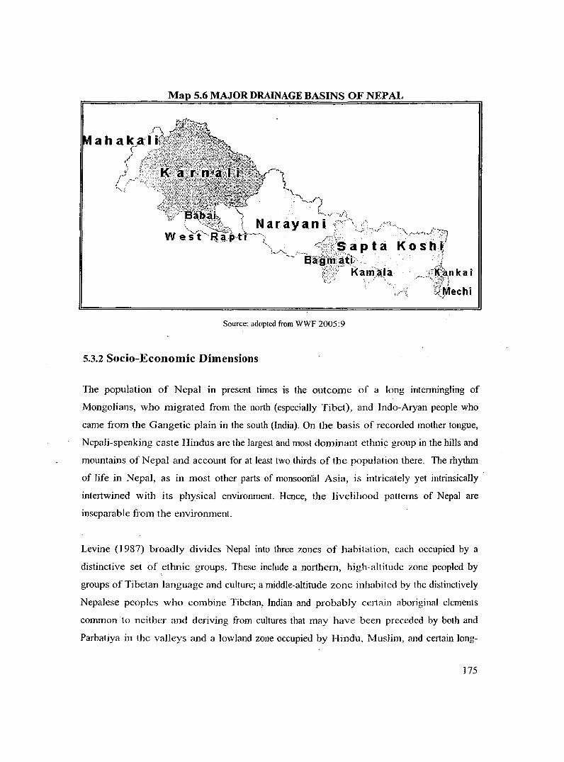
Nepal can be divided into three major river systems from east to west: the Kosi River, the
Naray;:mi River (India's Gandak River), and the Karnali River. The eastern part10 of the
country is drained by the Kosi River, which has seven tributaries. It is locally known as the
Sapt Kosi, which means seven Kosi rivers (Tamur, Likhu Khola, Dudh, Sun, Indrawati,
Tama, and Arun). The principal tributary is the Amn, which rises about 150 kilometers inside
the Tibetan Plateau. The Narayani River drains the central part of Nepal and also has seven
10 Roughly corresponding to Eastern Nepal
173
major tributaries (Daraudi, Seti, Madi, Kali, Marsyandi, Budhi, and Trisuli). The Kali, which
flows between the DhaulagirJ Himal and the Annapuma Himal (Himal is the Nepali
variation of the Sanskrit word Himalaya), is the main river of this drainage system. The river
system draining the western part of Nepal is the Karnali. Its three immediate tributaries are
the Bheri, Seti, and Kamali rivers, the latter being the major one. The Maha Kali, which also
is known as the Kali and which flows along the Nepal-India border on the western side, and
the Rapti River also are considered tributaries of the Kamali. All the rivers ultimately
become major tributaries of the Ganges River in northern India. After plunging through deep
gorges, these rivers deposit their heavy sediments and debris on the plains, thereby nurturing
them and renewing their a1luvial soil fertility. Once they reach the Terai Region, they often
overflow their banks onto wide floodplains during the summer monsoon season, periodically
shifting their courses and frequently flooding the lowland areas.
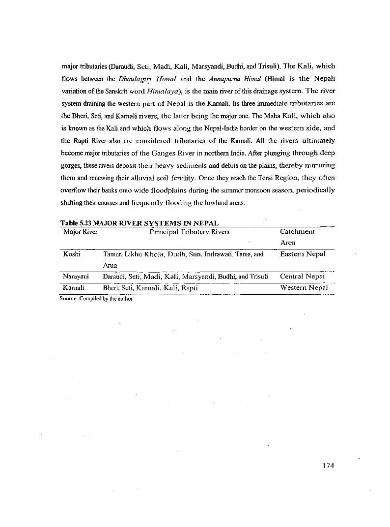
Table 5.23 MAJOR RIVER SYSTEMS IN NEPAL Major River
Koshi
Narayani
Karnali
Principal Tributary Rivers
Tamur, Likhu Khola, Dudh, Sun, Indrawati, Tama, and
Arun
Daraudi, Seti, Madi, Kali, Marsyandi, Budhi, and Trisuli
Bheri, Seti, Karnali, Kali, Rapti
Source: Compiled by the author
Catchment
Area
Eastern Nepal
Central Nepal
Western Nepal
174
Map 5.6 MAJOR DRAINAGE BASINS OF NEPAL
Source: adopted from WWF 2005:9
5.3.2 Socio-Economic Dimensions
The population of Nepal in present times is the outcome of a long intermingling of
Mongolians, who migrated from the north (especia11y Tibet), and Indo-Aryan people who
came from the Gangetic plain in the south (India). On the basis of recorded mother tongue,
Nepali-speaking caste Hindus are the largest and most dominant ethnic group in the hills and
mountains of Nepal and account for at least two thirds of the population there. The rhythm
of life in Nepal, as in most other parts of monsoon-al Asia, is intricately yet intrinsica11y
intertwined with its physical environment. Hence, the livelihood patterns of Nepal are
inseparable from the environment.
Levine (1987) broadly divides Nepal into three zones of habitation, each occupied by a
distinctive set of ethnic groups. These include a northern, high-altitude zone peopled by
groups of Tibetan language and culture; a middle-altitude zone inhabited by the distinctively
Nepalese peoples who combine Tibetan, Indian and probably certain aboriginal elements
common to neither and deriving from cultures that may have been preceded by both and
Parbatiya in the va11eys and a lowland zone occupied by Hindu, Muslim, and certain long-
175
resident populations, such as Tharu. Similarly, political scientists Joshi and Rose (Savada
1991) broadly classify the Nepalese population into three major ethnic groups in terms of
their origin: Indo-Nepalese, Tibeto-Nepalese, and indigenous Nepalese. In the case of the
first two groups, the direction of their migration and Nepal's landscapes appeared to have led
to their vertical distribution; most ethnic groups were found at particular altitudes. The first
group, comprising those of Indo- Nepalese origin, inhabited the more fertile lower hills, river
valleys, and Terai plains. The second major group consisted of communities of Tibeto
Mongol origin occupying the higher hills from the west to the east. The third and much
smaller group comprised a number of tribal communities, such as the Tharus and the
Dhimals of the Terai; they may be remnants of indigenous communities whose habitation
predates the advent oflndo-Nepalese and Tibeto-Mongol elements. Savada (1991) describes
the geographical distribution of Nepalese populations:
An extraordinarily complex terrain also affected the geographic distribution and interaction
among various ethnic groups. Within the general latitudinal sorting of Indo-Nepalese (lower
hills) and Tibeto-Nepalese (higher hills and mountains) groups, there was a lateral
(longitudinal) pattern, in which various ethnic populations were concentrated in specific
geographic pockets. The deeply cut valleys and high ridges tended to divide ethnic groups
into many small, relatively isolated, and more or less self- contained communities. This
pattern was especially prominent among the Tibeto-Nepalese population. For example, the
Bhote group was found in the far north, trans-Himalayan section of the Mountain Region,
close to the Tibetan border. The Sherpas, a subgroup within the Bhote, were concentrated in
the northeast, around the Mount Everest area. To the south of their areas were other Tibeto
Nepalese ethnic groups-the Gurung in the west-central hills and the Tamang and Rai in the
east-central hills particularly close to and east of the Kathmandu VaHey. The Magar group,
found largely in the central hills, was much more widely distributed than the Gurung,
Tamang, and Rai. In the areas occupied by the Limbu and Rai peoples, the Limbu domain
was located farther east in the hills, just beyond the Rai zone. The Tharu group was found in
the Terai, and the Paharis were scattered throughout Nepal. Newars largely were concentrated
in the Kathmandu Valley. However, because of their past migration as traders and merchants,
176
they also were found in virtually all the market centers, especially in the hills, and as far away
as Lhasa in Tibet. 11
In most ofNepal there is a strong tendency toward clustered housing in settlements, perhaps
reflecting previous defense needs. The earliest settlement locations were usually along ridge
crests possibly to avoid malarial areas. Although Nepal continued to be something of a
frontier well into the 191h century, most areas in the hills and mountains have had settled
populations of agriculturalists for hundreds of years. Nepali, the country's official language,
is an Indo-European language and has similarities to Hindi.
Nepal is among the poorest and least developed countries in the world with almost one-third
of its population living below the poverty line (Savada 1991). Various factors contribute to
its economic underdevelopment including geo-environmental and geomorphic constraints,
lack of adequate resource endowment, landlocked position, lack of institutions for
modernization, weak infrastructure, and a lack of policies conducive to development.
Agriculture is the mainstay of the economy, providing a livelihood for three-fourths of the
population and accounting for 38 percent of GDP 12• Industrial activity mainly involves the
processing of agricultural produce including jute, sugarcane, tobacco, and grain. Security
concerns relating to the Maoist conflict have led to a decrease in tourism, a key source of
foreign exchange. Nepal has considerable scope for exploiting its potential in hydropower
and tourism areas of recent foreign investment interest. Prospects for foreign trade or
investment in other sectors still remains poor, however, because of the sma11 size of the
economy, its technological backwardness, its remoteness, its landlocked geographic location,
its civil strife, and its susceptibility to natural disaster. Savada (1991) succinctly narrates the
economy ofNepaJ:
Nepal in the early 1990s was predominantly a rural-agricultural society, where more than 90
percent of the people lived in rural areas and depended on farming as a source of livelihood.
Even in settlements designated as urban areas, the rural-urban distinction easily was blurred;
11 Available at http://countrystudics.us/ (accessed 26107/07) 12 The CIA World Factbook, U.S. Department of State, Area Handbook of the US Library of Congress
177
approximately 50 percent of urbanites outside the three cities in the Katlunandu Valley were
engaged in farming for their liveiihood. Even in the Kathmandu VaHey cities, 30 to 40
percent of city dwellers were agriculturalists. In this sense, most urban areas were economic
extensions of rural areas, but with an urban manifestation and a commercial component.
Farming was the dominant order of society and the mainstay of the economy, a situation that
was unlikely to change, given the extremely sluggish pace of economic transformation 13•
Around one-fifth of the total land area in Nepal is cultivated and about 7 percent is under
cultivable category (but not cultivated). Forest land and shrubs together occupy 42 percent of
the total area of the country. Nearly 12 percent of the area is accounted by pastures and
another 19 percent is covered by snow, rocks, boulders, sand, landslide areas, barren land,
lakes and urban areas (CBS 1998).
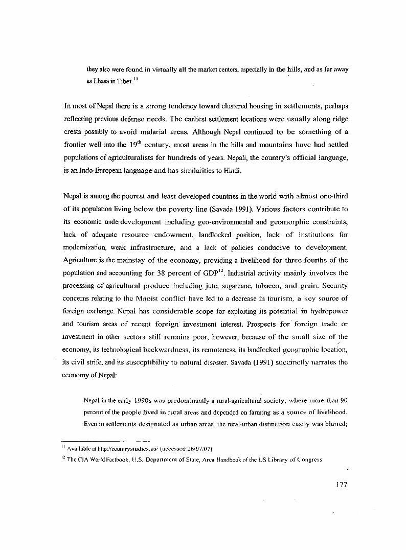
Cereals are the most important crops in Nepal occupying over 80 percent of the total cropped
area. Pulses are the other common crops. Horticultural crops including fruits, vegetables and
flowers are also grown. In recent years, vegetable farming in commercial scale has been
increasing (CBS 1998). Across the physiographic regions, the Terai is favourable for most of
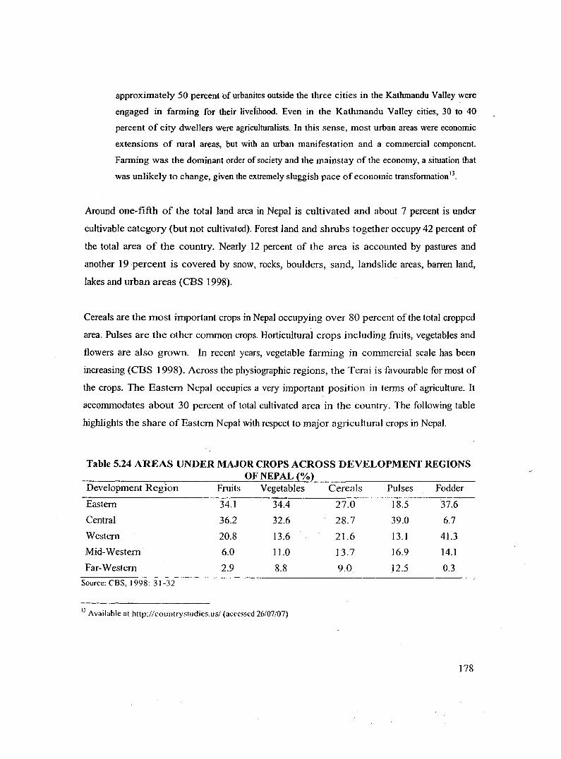
the crops. The Eastern Nepal occupies a very important position in terms of agriculture. It
accommodates about 30 percent of total cultivated area in the country. The following table
highlights the share of Eastern Nepal with respect to major agricultural crops in Nepal.
Table 5.24 AREAS UNDER MAJOR CROPS ACROSS DEVELOPMENT REGiONS OF NEPAL(%)
Development Region Fruits Vegetables Cereals Pulses Fodder
Eastern 34.1 34.4 27.0 18.5 37.6
Central 36.2 32.6 28.7 39.0 6.7
Western 20.8 13.6 21.6 13.1 41.3
Mid-Western 6.0 11.0 13.7 16.9 14.1
Far-Western 2.9 8.8 9.0 12.5 0.3
Source: CBS, I 998: 31-32
13 Available at http://countrystudies.us/ (accessed 26/07/07)
178
Fig 5.9 AREAS UNDER MAJOR CROPS IN EASTERN NEPAL TO TOTAL CROPPED AREA OF NEPAL
CD C) <a -c CD I:! CD a..
40.0.
30.0
Area under major crops in Eastern Nepal to total cropped area of Nepal
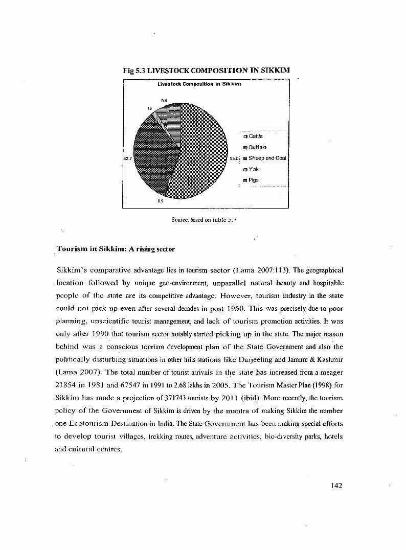
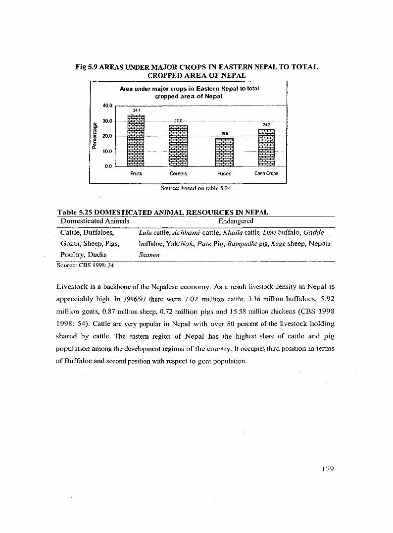
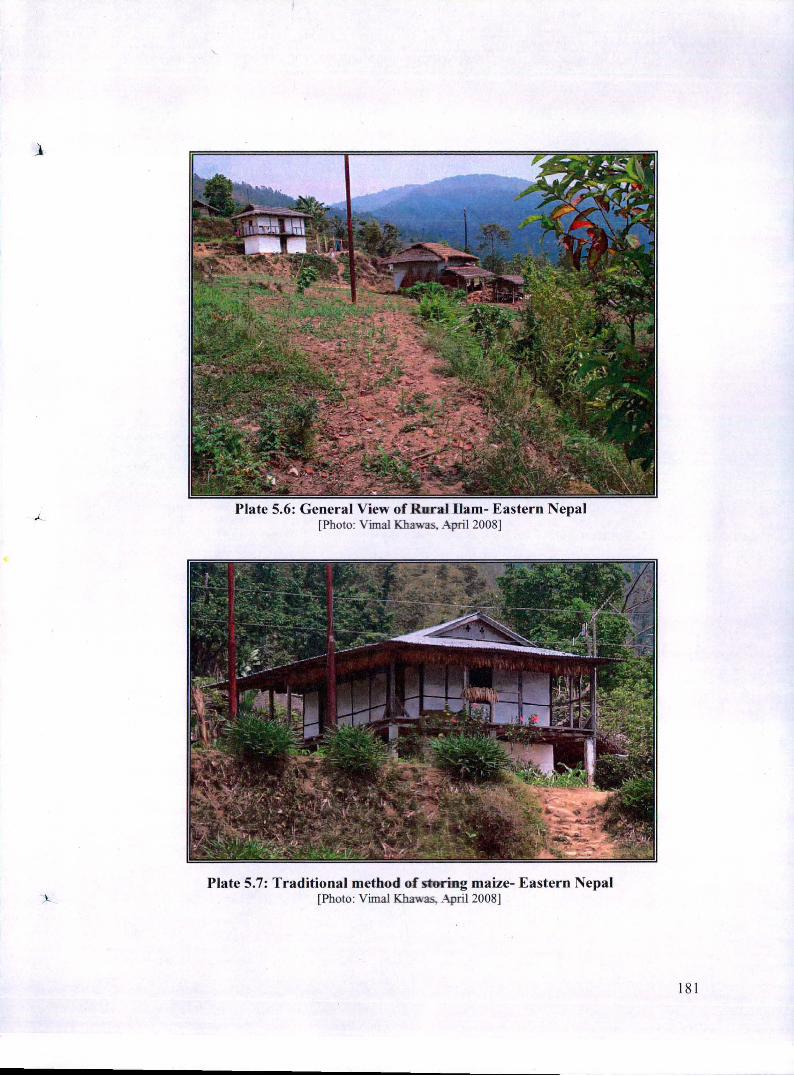
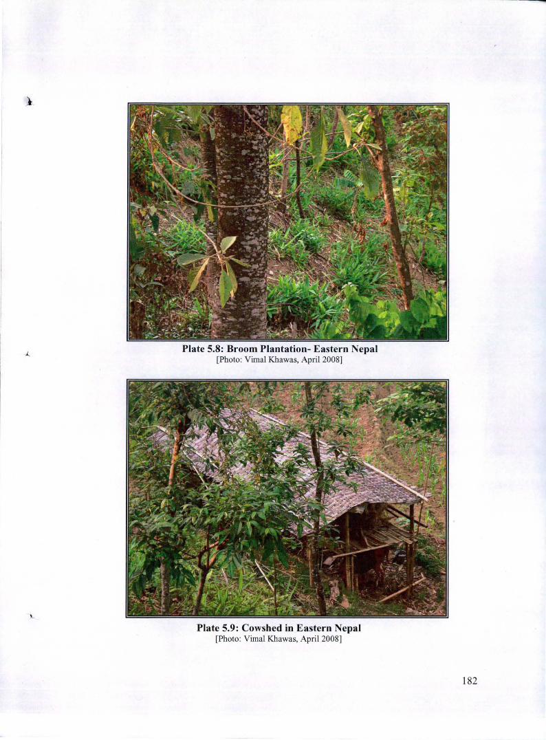
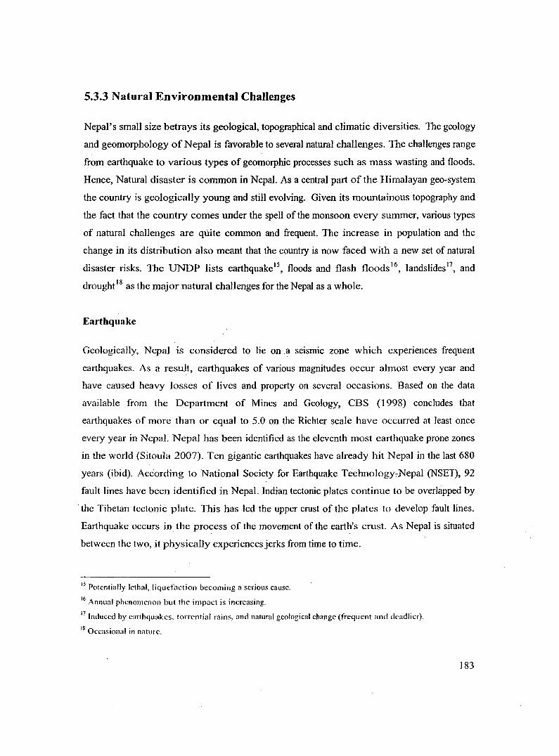
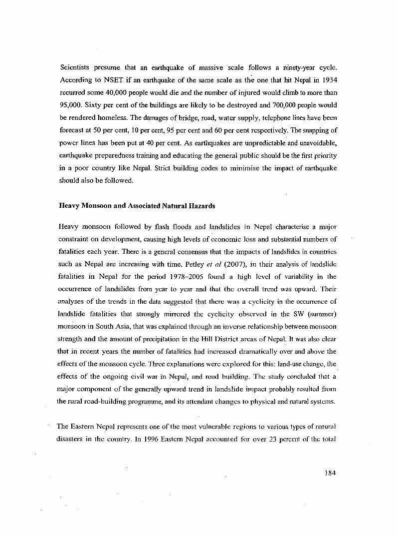
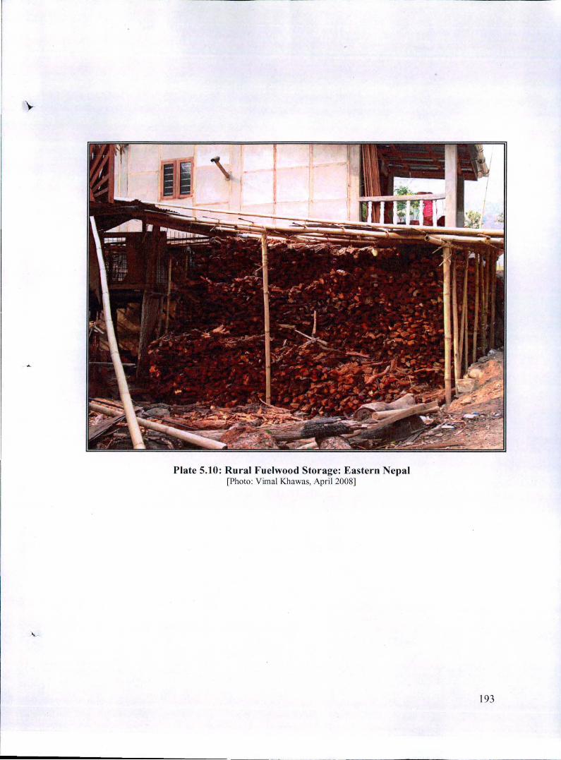
Plate 5.9: Cowshed in Eastern Nepal [Photo: Vimal Khawas, Apri l 2008]
182
5.3.3 Natural Environmental Challenges
Nepal's small size betrays its geological, topographical and climatic diversities. The geology
and geomorphology of Nepal is favorable to several natural challenges. The challenges range
from earthquake to various types of geomorphic processes such as mass wasting and floods.
Hence, Natural disaster is common in Nepal. As a central part of the Himalayan geo-system
the country is geologically young and still evolving. Given its mountainous topography and
the fact that the country comes under the spell of the monsoon every summer, various types
of natural challenges are quite common and frequent. The increase in population and the
change in its distribution also meant that the country is now faced with a new set of natural
disaster risks. The UNDP lists earthquake15, floods and flash floods 16
, landslides 17, and
droughe 8 as the major natural challenges for the Nepal as a whole.
Earthquake
Geologica11y, Nepal is considered to lie on a seismic zone which experiences frequent
earthquakes. As a result, earthquakes of various magnitudes occur almost every year and
have caused heavy losses of lives and property on several occasions. Based on the data
available from the Department of Mines and Geology, CBS (1998) concludes that
earthquakes of more than or equal to 5.0 on the Richter scale have occurred at least once
every year in Nepal. Nepal has been identified as the eleventh most earthquake prone zones
in the world (Sitoula 2007). Ten gigantic earthquakes have already hit Nepal in the last 680
years (ibid). According to National Society for Earthquake Technology.,-Nepal (NSET), 92
fault lines have been identified in Nepal. Indian tectonic plates continue to be overlapped by
·the Tibetan tectonic plate. This has Jed the upper crust of the plates to develop fault lines.
Earthquake occurs in the process of the movement of the earth's crust. As Nepal is situated
between the two, it physica1Jy experiences jerks from time to time.
15 Potentially lethal, liquefaction becoming a serious cause. 16 Annual phenomenon but the impact is increasing. 17 Induced by earthquakes, torrential rains, and natural geological change (frequent and deadlier). 18 Occasional in nature.
183
Scientists presume that an earthquake of massive scale follows a ninety-year cycle.
According to NSET if an earthquake of the same scale as the one that hit Nepal in 1934
recurred some 40,000 people would die and the number of injured would cJimb to more than
95,000. Sixty per cent of the buildings are Jikely to be destroyed and 700,000 people would
be rendered homeless. The damages of bridge, road, water supply, telephone lines have been
forecast at 50 per cent, I 0 per cent, 95 per cent and 60 per cent respectively. The snapping of
power lines has been put at 40 per cent. As earthquakes are unpredictable and unavoidable,
earthquake preparedness training and educating the general public should be the first priority
in a poor country like Nepal. Strict building codes to minimise the impact of earthquake
should also be followed.
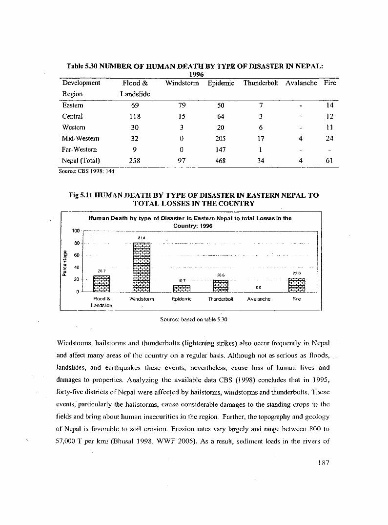
Heavy Monsoon and Associated Natural Hazards
Heavy monsoon followed by flash floods and landslides in Nepal characterise a maJor
constraint on development, causing high levels of economic loss and substantial numbers of
fatalities each year. There is a general consensus that the impacts of landslides in countries
such as Nepal are increasing with time. Petley et a/ (2007), in their analysis of landslide
fatalities in Nepal for the period 1978-2005 found a high level of variability in the
occurrence of landslides from year to year and that the overall trend was upward. Their
analyses of the trends in the data suggested that there was a cyclicity in the occurrence of
landslide fatalities that strongly mirrored the cyclicity observed in the SW (summer)
monsoon in South Asia, that was explained through an inverse relationship between monsoon
strength and the amount of precipitation in the Hill District .areas of Nepal. It was also clear
that in recent years the number of fatalities had increased dramatica1ly over and above the
effects of the monsoon cycJe. Three explanations were explored for this: land-use change, the
effects of the ongoing civil war in Nepal; and road building. The study concluded that a
major component of the generally upward trend in landslide impact probably resulted from
the rural road-building programme, and its attendant changes to physical and natural systems.
The Eastern Nepal represents one of the most vulnerable regions to various types of natural
disasters in the country. In 1996 Eastern Nepal accounted for over 23 percent of the total
184
human losses, 33 percent of animal loses, 63 percent of affected family, 95 percent of the
financial loss and about 58 percent of the affected land in the country to natural hazards. Of
the various natural disasters windstorm, Floods and Landslides seem to be the major forces
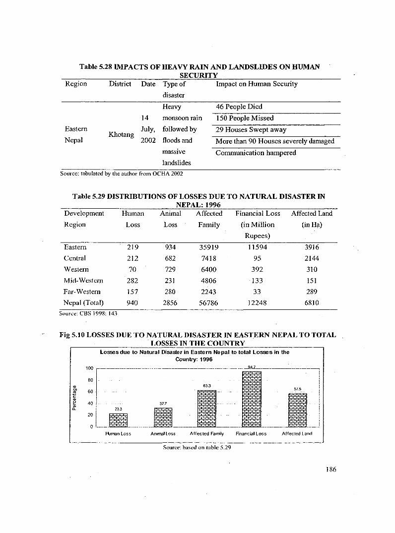
that inflict severe human insecurity in the region. Heavy monsoon rains triggered flash floods
and massive landslides in the villages of Sungdel and Dipsung of Khotang District in eastern
Nepal, on 14 July, 2002 (OCHA 2002). Some 46 people were feared killed and 150 missed.
The landslides reportedly also swept away 29 houses and a health post, and more than 90
houses in the area were severely damaged. To make the situation worse communication
between Diktel, the district capital, and Kathmandu had been hampered since the telecom
tower in Udaypur was destroyed in the armed conflict affecting Nepal, a few months ago.
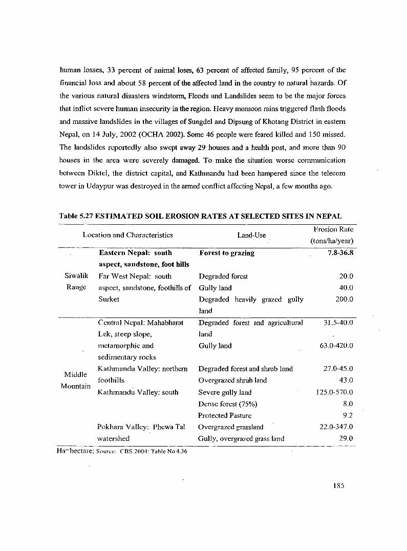
Table 5.27 ESTIMATED SOIL EROSION RATES AT SELECTED SITES IN NEPAL
Location and Characteristics Land-Use
Eastern Nepal: south Forest to grazing
aspect, sandstone, foot hills
Siwalik Far West Nepal: south Degraded forest
Range aspect, sandstone, foothills of Gully land
Middle
Mountain
Surket Degraded heavily grazed gully
land
Central Nepal: Mahabharat
Lek, steep slope,
metamorphic and
sedimentary rocks
Kathmandu Valley: northern
foothills
Kathmandu Valley: south
Pokhara Valley: Phewa Tal
watershed
Degraded forest and agricultural
land
Gu1ly land
Degraded forest and shrub land
Overgrazed shillb land
Severe gully land
Dense forest (75%)
Protected Pasture
Overgrazed grassland
Gully, overgrazed grass land
Ha=hectare; Source: CBS 2004: Table No 4.36
Erosion Rate
(tons/ha/year)
7.8-36.8
20.0
40.0
200.0
31.5-40.0
63.0-420.0
27.0-45.0
43,0
125.0-570.0
8.0
9.2
22.0-347.0
29.0
] 85
Table 5.28 IMPACTS OF HEAVY RAIN AND LANDSLIDES ON HUMAN SECURITY
Region District Date Type of Impact on Human Security
disaster
Heavy 46 People Died
14 monsoon rain 150 People Missed
Eastern July, followed by 29 Houses Swept away
Nepal Khotang
2002 floods and More than 90 Houses severely damaged
massive Communication hampered
landslides
Source: tabulated by the author from OCHA 2002
Table 5.29 DISTRJBUTIONS OF LOSSES DUE TO NATURAL DISASTER IN NEPAL: 1996
Development Human Animal Affected Financial Loss Affected Land
Region Loss Loss Family (in Million (in Ha)
Rupees)
Eastern 219 934 35919 11594 3916
Central 212 682 7418 95 2144
Western 70 729 6400 392 310
Mid-Western 282 231 4806 133 151
Far-Western 157 280 2243 33 289
Nepal (Total) 940 2856 56786 12248 6810
Source: CBS 1998: 143
Fig 5.10 LOSSES DUE TO NATURAL DISASTER IN EASTERN NEPAL TO TOTAL LOSSES IN THE COUNTRY
<I> 0>
"' c <I> e Cll a.
losses due to Natural Disaster in Eastern Nepal to total losses in the Country:1996
Source: based on the infonnation available in CBS 1998: 138-154
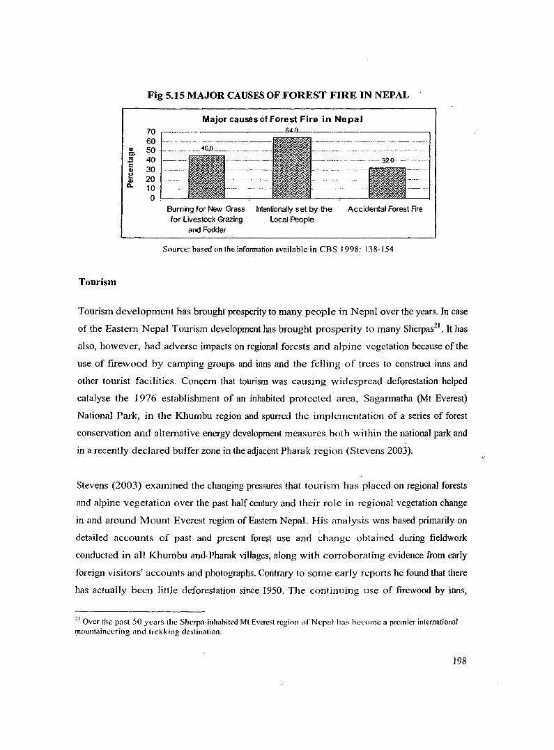
Tourism development has brought prosperity to many people in Nepal over the years. In case
of the Eastern Nepal Tourism development has brought prosperity to many Sherpas21• It has
also, however, had adverse impacts on regional forests and alpine vegetation because of the
use of firewood by camping groups and inns and the felling of trees to construct inns and
other tourist facilities. Concern that tourism was causing widespread deforestation helped
catalyse the 1976 establishment of an inhabited protected area, Sagarmatha (Mt Everest)
National Park, in the Khumbu region and spurred the implementation of a series of forest
conservation and alternative energy development measures both within the national park and
in a recently declared buffer zone in the adjacent Pharak region (Stevens 2003).
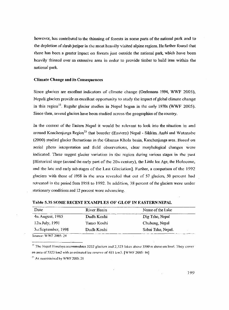
Stevens (2003) examined the changing pressures that tourism has placed on regional forests
and alpine vegetation over the past half century and their role in regional vegetation change
in and around Mount Everest region of Eastern Nepal. His analysis was based primarily on
detailed accounts of past and present forest use and change obtained during fieldwork
conducted in all Khumbu and Pharak villages, along with corroborating evidence from early
foreign visitors' accounts and photographs. Contrary to some early reports he found that there
has actually been little deforestation since 1950. The continuing use of firewood by inns,
11 Over the past 50 years the Sherpa-inhabited Mt Everest region of Nepal has hecome a premier international mountaineering and trekking destination.
198
however, has contributed to the thinning of forests in some parts of the national park and to
the depletion of shrub juriiper in the most heavily visited alpine regions. He further found that
there has been a greater impact on forests just outside the national park, which have been
heavily thinned over an extensive area in order to provide timber to build inns within the
national park.
Climate Change and its Consequences
Since glaciers are excellent indicators of climate change (Oerlemans 1994, WWF 2005),
Nepali glaciers provide an excellent opportunity to study the impact of global climate change
in this region22. Regular glacier studies in Nepal began in the early 1970s (WWF 2005).
Since then, several glaciers have been studied across the geographies of the country.
In the context of the Eastern Nepal it would be relevant to look into the situation in and
around Kanchenjunga Region23 that boarder (Eastern) Nepal - Sikkim. Asahi and Watanabe
(2000) Stt:Jdied glacier fluctuations in the Ghunsa Khola basin, Kanchenjunga area. Based on
aerial photo interpretation and field observations, clear morphological changes were
indicated. These suggest glacier variation in the region during various stages in the past
[Historical stage (around the early part of the 20th century), the Little Ice Age, the Holocene,
and the late and early sub-stages of the Last Glaciation]. Further, a comparison of the 1992
glaciers with those of 1958 in the area revealed that out of 57 glaciers, 50 percent had
retreated in the period from 1958 to 1992. In addition, 38 percent of the glaciers were under
stationary conditions and 12 percent were advancing.
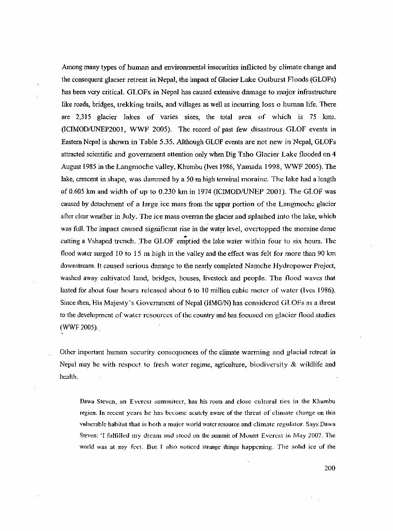
Table 5.35 SOME RECENT EXAMPLES OF GLOF IN EASTERN NEPAL
Date
4th August, 1985
12th July, 1991
3rd September, .1998
Source: WWF 2005: 24
River Basin
Dudh Koshi
TamoKoshi
Dudh Koshi
Name of the Lake
Dig Tsho, Nepal
Chubung, Nepal
Sabai Tsho, Nepal.
22 The Nepal Himalaya accommodates 3252 glaciers and 2,323 lakes above 3500 m above sea level. They cover
an area of5323 krn2 with an estimated icc reserve of481 km3. [WWF 2005: 16] 2' As summarised by WWF 2005: 2 I
199
Among many types of human and environmental insecurities inflicted by climate change and
the consequent glacier retreat in Nepal, the impact of Glacier Lake Outburst Floods (GLOFs)
has been very critical. GLOFs in Nepal has caused extensive damage to major infrastructure
like roads, bridges, trekking trails, and villages as well as incurring loss o human life. There
are 2,315 glacier lakes of varies sizes, the total area of which is 75 lam.
(ICIMOD/UNEP2001, WWF 2005). The record of past few disastrous GLOF events in
Eastern Nepal is shown in Table 5.35. Although GLOF events are not new in Nepal, GLOFs
attracted scientific and government attention only when Dig Tsho Glacier Lake flooded on 4
August 1985 in the Langmoche valley, Khumbu (Ives 1986, Yamada 1998, WWF 2005). The
lake, crescent in shape, was dammed by a 50 m high terminal moraine. The lake had a length
of 0.605 km and width of up to 0.230 km in 1974 (ICIMOD/UNEP 2001 ). The GLOF was
caused by detachment of a large ice mass from the upper portion of the Langmoche glacier
after clear weather in July. The ice mass overran the glacier and splashed into the lake, which
was full. The impact caused significant rise in the watt?r level, overtopped the moraine dame ... cutting a Vshaped trench . .The GLOF emptied the lake water within four to six hours. The
flood water surged 1 0 to 15 m high in the valley and the effect was felt for more than 90 km
downstream. It caused serious damage to the nearly completed Namche Hydropower Project,
washed away cultivated land, bridges, houses, livestock and people. The flood waves that
lasted for about four hours released about 6 to I 0 million cubic meter of water (lves 1986).
Since then, His Majesty's Government of Nepal (HMG/N) has considered GLOFs as a threat
to the development of water resources of the country and has focused on glacier flood studies
(WWF 2005) ..
Other important human security consequences of the climate warming and glacial retreat in
Nepal may be with respect to fresh water regime, agriculture, biodiversity & wildlife and
health.
Dawa Steven, an Everest summiteer, has his roots and close cultural ties in tl1e Khumbu
region. Jn recent years l1e has become acutely aware of the threat of climate change on this
vulnerable habitat that is both a major world water resource and climate regulator. Says Dawa
Steven: '1 fulfilled my dream and stood on the summit of Mount Everest in May 2007. The
world was at my feet. But. I also noticed strange things happening. The solid ice of the
200
Khumbu icefall had melted into slush and, on the way down, was crackling and crumbling
beneath my feet. Fellow Sherpas on the mountain were running for their lives and asking me
to get down as quickly as possible. I did, and on that same day the entire ice field simply
collapsed. I was shocked, and wanted to understand why this had happened. After returning
to Kathmandu I began my quest for answers. Most of my findings pointed towards the effects
of global warming.' 24
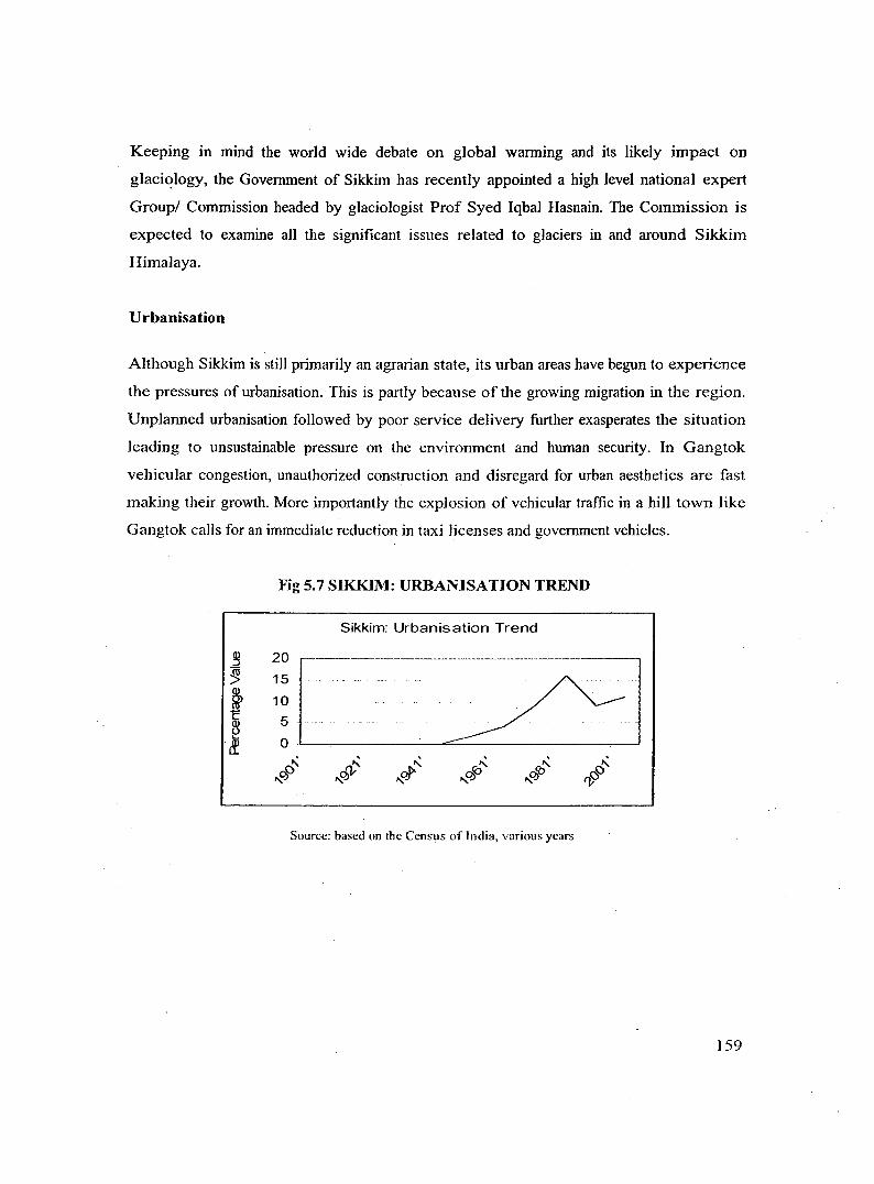
Urbanisation
In developing countries like Nepal, urbanisation is supposed to have come out because rural
migrants have been 'pushed' rather than pulled into the urban areas, as a result of great and
mounting population pressure in the rural areas. Although Nepal in 2001 had only 16 percent
of its total population living in urban locations the rate at which urbanisation has been taking
place in recent decades is a cause of serious concern both from environmental and human
security point of view. Urban population as percent of total population has been growing
steadily in the last five decades. Between 1952/54 and 1971. urban population increased
rather sluggishly from 3 percent to 4 percent. Since the eighties the growth has accelerated
from 6 percent to 14 percent of the total population (Sharma [undated]).
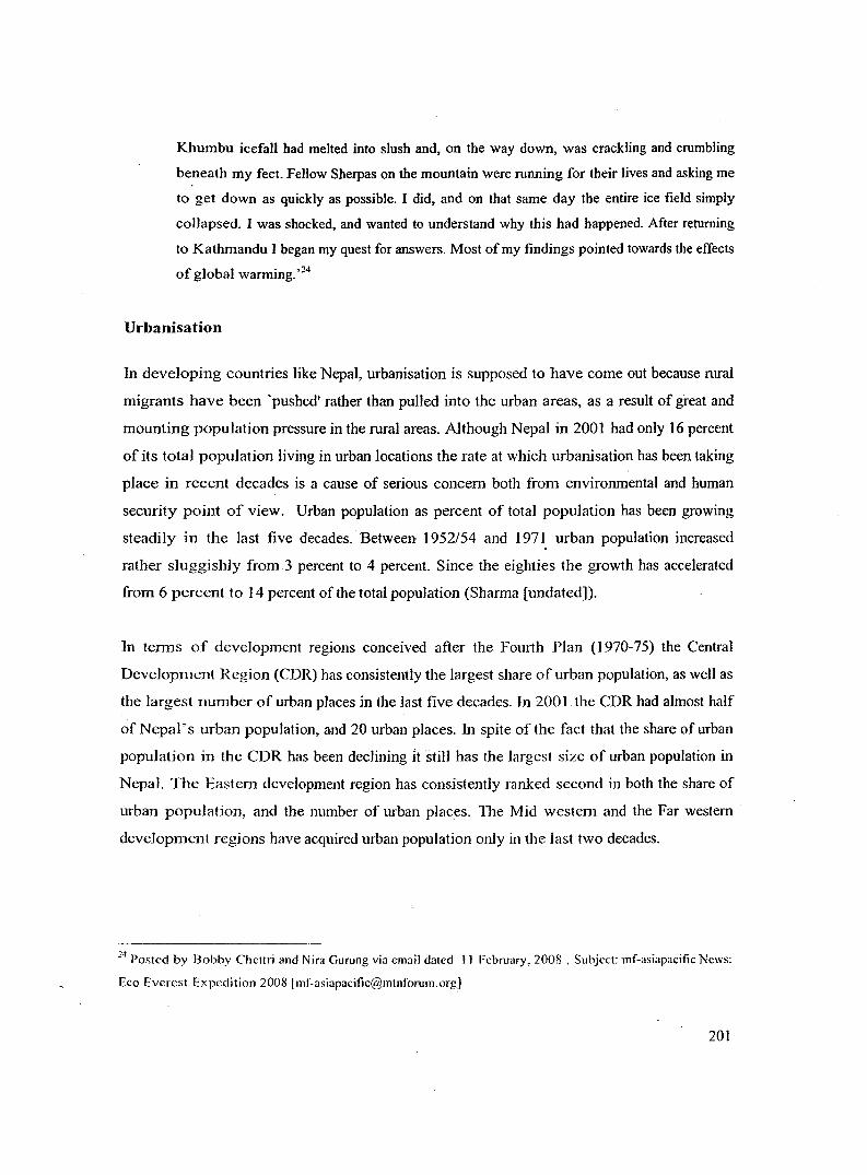
In terms of development regions conceived after the Fourth Plan (1970-75) the Central
Development Region (CDR) has consistently the largest share of urban population, as we11 as
the largest number of urban places in the last five decades. In 2001 the CDR had almost half
of Nepal's urban population, and 20 urban places. In spite of the fact that the share of urban
population in the CDR has been declining It still has the largest size of urban population in
Nepal. The Eastern development region has consistently ranked second in both the share of
urban population, and the number of urban places. The Mid western and the Far western
development regions have acquired urban population only in the last two decades.
14 Posted by Bobby Chcttri and Nira Gurung via email dated II February, 2008 . Subject: mf-asiapacific News: