26
Charts&Tides User Guide http://navimatics.com

Charts&Tides User Guide
http://navimatics.com

Charts&Tides © 2008-‐2010 Navimatics Corporation
2
Contents Contents ................................................................................................................................ 2 Overview .............................................................................................................................. 3 Conventions ........................................................................................................................ 3 Disclaimer ............................................................................................................................ 4 Main Chart View (iPad) .................................................................................................. 5 Search View (iPad) ........................................................................................................... 6 Main Chart View (iPhone) ............................................................................................. 7 Search View (iPhone) ..................................................................................................... 8 Starting Charts&Tides .................................................................................................... 9 Repositioning The Chart ................................................................................................ 9 Locking North Up .............................................................................................................. 9 Tracking Your Vessel .................................................................................................... 10 Searching For Features ................................................................................................ 10 Getting Feature Information ...................................................................................... 12 Sky Calendar ..................................................................................................................... 13 Tides/Currents ................................................................................................................ 14 Weather Stations ............................................................................................................ 15 ActiveCaptain Markers ................................................................................................. 16 Editing ActiveCaptain Markers ................................................................................. 17 Ruler Tool .......................................................................................................................... 18 New Waypoint ................................................................................................................. 19 Goto/Edit Waypoints .................................................................................................... 20 Waypoint Navigation .................................................................................................... 21 Information And Instruments ................................................................................... 23 ActiveCaptain Integration ........................................................................................... 25

Charts&Tides © 2008-‐2010 Navimatics Corporation
3
Overview Thank you for choosing Charts&Tides. Charts&Tides is a versatile marine navigation product for the iPad and the iPhone. It features a continuous and consistent offline chart database, quick search of features by name, 3d bathymetry, real time tide/current predictions for any date and time, access to weather stations, integration with the ActiveCaptain interactive cruising guidebook and a number of features useful for marine navigation. The Charts&Tides complete feature set is available on both the iPad and the iPhone and it is optimized for the particular device and screen format it is running on.
Conventions Charts&Tides utilizes a number of well-‐accepted international conventions and standards relating to marine cartography and navigation.
Symbology Charts&Tides uses symbology from the International Hydrographic Organization (IHO). This is the worldwide-‐accepted standard for rendering marine chart data on computer displays. The symbols are documented in the US Chart No 1.
Units Below are the various units used:
• Soundings: either feet (ft) or meters (m) based on configuration. • Obstructions (rocks, wrecks, etc): either feet (ft) or meters (m) based on configuration.
• Tides: either feet (ft) or meters (m) based on configuration. • Currents: always in knots (kn or kt). • Elevations, bridge clearances, beacons/lights: always in meters (m).
• Distances: always in nautical miles (M).
Charts&Tides © 2008-‐2010 Navimatics Corporation
4
• Bearings, tracks, etc: either magnetic or true degrees based on configuration.
• Speeds: always in knots (kn or kt).
Tides Tides in the United States are measured from MLLW (Mean Lower Low Water).
Disclaimer THE SOFTWARE PRODUCT IS PROVIDED "AS IS" WITHOUT ANY EXPRESS OR IMPLIED WARRANTY OF ANY KIND, INCLUDING BUT NOT LIMITED TO THE WARRANTIES OF MERCHANTABILITY, FITNESS FOR A PARTICULAR PURPOSE AND NON-‐INFRINGEMENT. NAVIMATICS CORPORATION DOES NOT WARRANT OR ASSUME RESPONSIBILITY FOR THE ACCURACY OR COMPLETENESS OF ANY INFORMATION (INCLUDING THE ASSOCIATED MAPS/CHARTS), TEXT, GRAPHICS, LINKS OR OTHER ITEMS CONTAINED WITHIN THE SOFTWARE PRODUCT. THE ENTIRE RISK AS TO THE ACCURACY, QUALITY AND PERFORMANCE OF THE SOFTWARE PRODUCT REMAINS WITH YOU. IN NO EVENT SHALL NAVIMATICS CORPORATION BE LIABLE FOR ANY DIRECT, INDIRECT, INCIDENTAL, SPECIAL, EXEMPLARY, OR CONSEQUENTIAL DAMAGES (INCLUDING, BUT NOT LIMITED TO, PROCUREMENT OF SUBSTITUTE GOODS OR SERVICES; LOSS OF USE, DATA, OR PROFITS; OR BUSINESS INTERRUPTION) HOWEVER CAUSED AND ON ANY THEORY OF LIABILITY, WHETHER IN CONTRACT, STRICT LIABILITY, OR TORT (INCLUDING NEGLIGENCE OR OTHERWISE) ARISING IN ANY WAY OUT OF THE USE OF THIS SOFTWARE PRODUCT, EVEN IF ADVISED OF THE POSSIBILITY OF SUCH DAMAGE. THIS LIMITATION SHALL APPLY TO CLAIMS OF PERSONAL INJURY TO THE EXTENT PERMITTED BY LAW.

Charts&Tides © 2008-‐2010 Navimatics Corporation
5
Main Chart View (iPad)
Search Bar
Vessel Track (Degrees True or Magnetic)
Main Chart View
Vessel Speed
Track Vessel
Bookmarks
Chart North
Waypoint Distance/Bearing
Scale
Lock North Up Ruler Tool Waypoints Switch View
Info/Instruments
Charts&Tides © 2008-‐2010 Navimatics Corporation
6
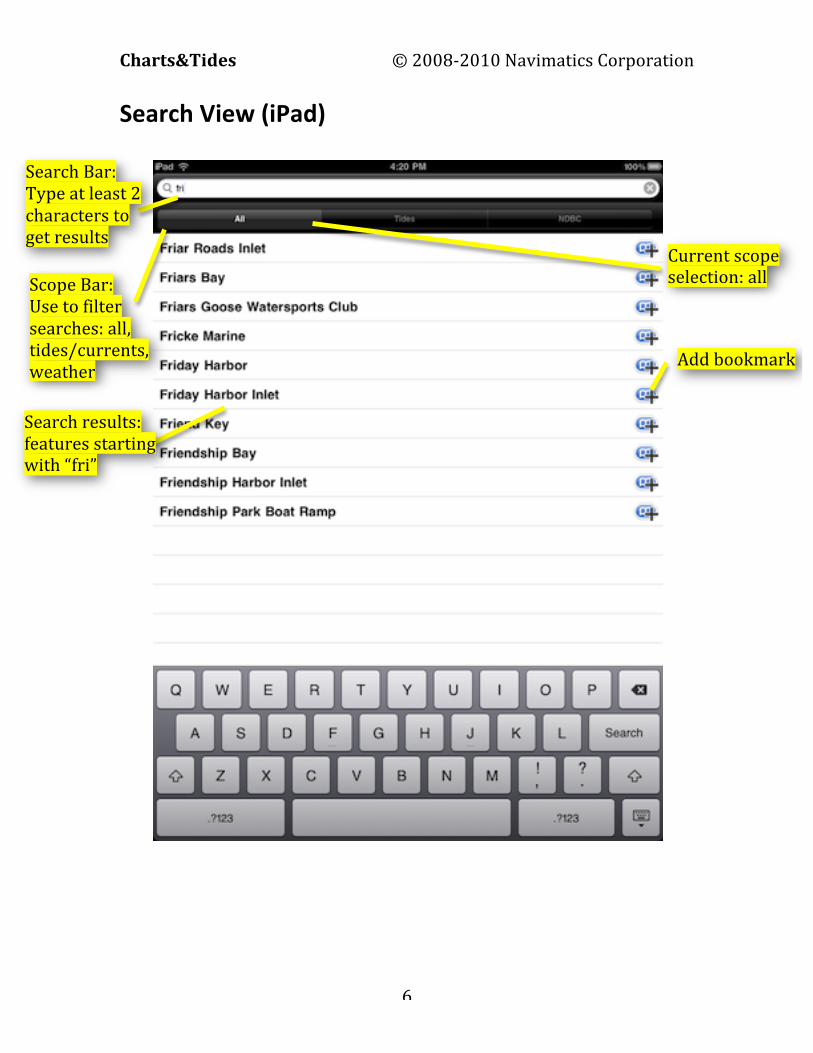
Search View (iPad)
Search Bar: Type at least 2 characters to get results
Scope Bar: Use to filter searches: all, tides/currents, weather
Search results: features starting with “fri”
Current scope selection: all
Add bookmark

Charts&Tides © 2008-‐2010 Navimatics Corporation
7
Main Chart View (iPhone)
Track Vessel Lock North Up Ruler Tool
Waypoints Info/Instruments
Search Bar
Main Chart View
Vessel
Vessel Track (Degrees True or Magnetic)
Vessel Speed
Scale
Chart North
Waypoint Distance/Bearing
Switch View
Bookmarks
Charts&Tides © 2008-‐2010 Navimatics Corporation
8
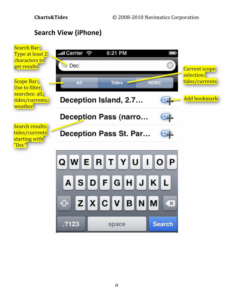
Search View (iPhone)
Search Bar: Type at least 2 characters to get results
Scope Bar: Use to filter searches: all, tides/currents, weather
Current scope selection: tides/currents
Add bookmark
Search results: tides/currents starting with “Dec”

Charts&Tides © 2008-‐2010 Navimatics Corporation
9
Starting Charts&Tides When you start Charts&Tides you are presented with the Main Chart View. At the same time the software will use the device’s GPS hardware (if available) to find your current location. Once a GPS signal is acquired, your vessel will be displayed on the chart, if the Main Chart View is currently positioned over the area of your location. Charts&Tides will continuously track the location of your vessel and update its location on the chart accordingly.
Repositioning The Chart You can use your fingers to reposition the chart. Use one finger to move the chart without changing its scale or orientation. Use two fingers to move, scale or rotate the chart in a natural manner. Just put two fingers on the screen, drag them to a new location and see what happens! Note that if the Track Vessel button is currently selected, it will be deselected after you reposition the chart with your fingers. You can also double tap the screen to zoom the chart in. If the Track Vessel button is currently selected, it will remain selected after a double tap.
Locking North Up Tap the Lock North Up toolbar button to disallow rotation of the chart. The chart will be displayed with North always up. Tap the button again to allow rotation of the chart. This is what the Lock North Up button looks like:
Charts&Tides © 2008-‐2010 Navimatics Corporation
10
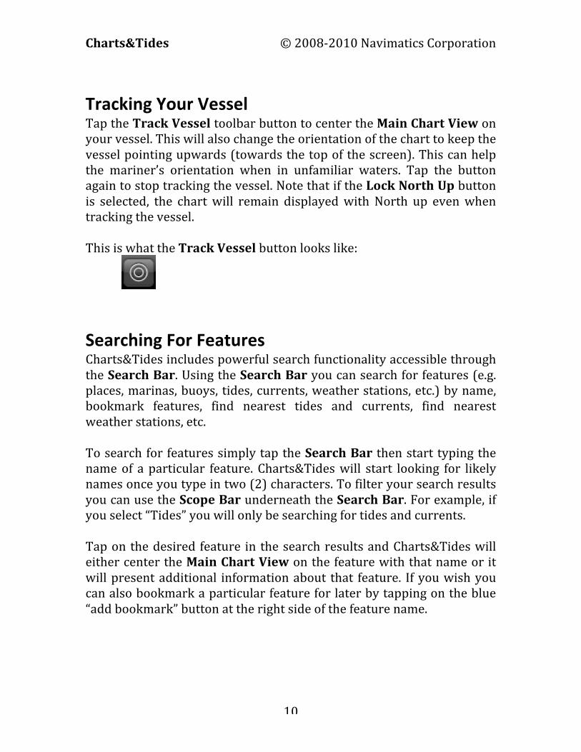
Tracking Your Vessel Tap the Track Vessel toolbar button to center the Main Chart View on your vessel. This will also change the orientation of the chart to keep the vessel pointing upwards (towards the top of the screen). This can help the mariner’s orientation when in unfamiliar waters. Tap the button again to stop tracking the vessel. Note that if the Lock North Up button is selected, the chart will remain displayed with North up even when tracking the vessel. This is what the Track Vessel button looks like:
Searching For Features Charts&Tides includes powerful search functionality accessible through the Search Bar. Using the Search Bar you can search for features (e.g. places, marinas, buoys, tides, currents, weather stations, etc.) by name, bookmark features, find nearest tides and currents, find nearest weather stations, etc. To search for features simply tap the Search Bar then start typing the name of a particular feature. Charts&Tides will start looking for likely names once you type in two (2) characters. To filter your search results you can use the Scope Bar underneath the Search Bar. For example, if you select “Tides” you will only be searching for tides and currents. Tap on the desired feature in the search results and Charts&Tides will either center the Main Chart View on the feature with that name or it will present additional information about that feature. If you wish you can also bookmark a particular feature for later by tapping on the blue “add bookmark” button at the right side of the feature name.

Charts&Tides © 2008-‐2010 Navimatics Corporation
11
You can access your bookmarks at any time by tapping on the blue bookmark icon at the right side of your Search Bar. Charts&Tides will present you with the Bookmark View, which allows you to select any of your bookmarked features. Additionally there may be a number of “smart” bookmarks (in blue color), with additional functionality (e.g. find tides and currents near your vessel).

Charts&Tides © 2008-‐2010 Navimatics Corporation
12
Getting Feature Information You can get more information about features at a particular location. Make sure that the Ruler button is not selected and simply tap the Main Chart View and a list of features will be displayed. Some features will have additional information attached to them, such as NOAA notes or tides. Such features will be marked with a chevron symbol. Tap on these features to access the additional information.

Charts&Tides © 2008-‐2010 Navimatics Corporation
13
Sky Calendar Charts&Tides includes a sky calendar that will compute sun and moon position information for any location or date. Just tap at a particular location and select “Chart Location” (the first item) on the feature list. The information shown by Sky Calendar includes times of nautical and civil twilights, sunrise and sunset, time at noon, sun declination and moon phase. To see the sun and moon positions for a different day, just use the date picker at the bottom.

Charts&Tides © 2008-‐2010 Navimatics Corporation
14
Tides/Currents Charts&Tides includes tide harmonics data that can be used to compute tide and current levels in real time. Tides/currents are accessible through the Search Bar as explained earlier. You can search for tides/currents by name, bookmark them and search for tides/currents near your vessel or current chart location. Choosing a tide/current station presents you with the Tide View.
On the top of the Tide View there is a graph that shows the tide/current levels for a full day (midnight to midnight in local time). The tide/current level for the current time is also displayed at the bottom of the tide graph. You can tap or drag your finger anywhere on the graph and you will get the tide/current level for that particular time of the day. On the bottom of the Tide View there is a date picker that allows you to choose any date you want and see the graph for that date.

Charts&Tides © 2008-‐2010 Navimatics Corporation
15
Weather Stations Charts&Tides provides access to current weather conditions through the NDBC (National Data Buoy Center) station network. NDBC stations are also accessible through the Search Bar. The full Search Bar functionality is available, including search by name and nearest station searches. Choosing an NDBC station presents you with the NDBC Station View.
The NDBC Station View includes information about the current weather conditions at that particular station. It will usually include information such as wind/gust speed and direction, barometric pressure, temperature and dew point and it may also include information about wave heights and periods. Please note: Since weather is a highly dynamic process that cannot be computed from data stored in the device, this particular feature requires an active EDGE, 3G or WiFi connection to access current weather conditions.

Charts&Tides © 2008-‐2010 Navimatics Corporation
16
ActiveCaptain Markers Charts&Tides supports integration with the Interactive Cruising Guidebook from activecaptain.com. Once Charts&Tides loads the ActiveCaptain data (see ActiveCaptain Integration) you will have access to the wealth of ActiveCaptain information, which includes detailed information about marinas and anchorages and local knowledge not available on charts. ActiveCaptain markers will appear on your chart as one of the following icons:
Marina Anchorage Local Knowledge Hazard
Tapping on one of these icons will give you access to the feature list for the particular location. Tapping again on a particular ActiveCaptain marker, will get you detailed information about the marker.

Charts&Tides © 2008-‐2010 Navimatics Corporation
17
Editing ActiveCaptain Markers You can edit most of the information about a particular ActiveCaptain marker. You can edit existing fields, add new fields and most importantly add your own ratings, reviews and comments. It is important to understand how editing ActiveCaptain markers works. There is a difference between editing primary information about a marker and submitting your own review or comment. When you edit primary information about a marker (e.g. a marina’s phone number), your changes are submitted to the ActiveCaptain service for approval. These “pending” changes will be shown on your device in a different color to show that these are temporary changes that you have made, but have not yet been approved by the ActiveCaptain service. When at a later time you update your local data with data from the ActiveCaptain service (see ActiveCaptain Integration), your pending changes will have been integrated into the master ActiveCaptain service. This can mean that your changes were accepted, accepted with additional editing or rejected. This process ensures that ActiveCaptain has always quality cruising data. On the other hand when you add a review or comment to a marker, your review or comment gets accepted immediately. This ensures that your opinion and voice is heard. [In rare cases ActiveCaptain will reject a review or comment because of the use of abusive language.]

Charts&Tides © 2008-‐2010 Navimatics Corporation
18
Ruler Tool The Ruler Tool allows you to measure distance and bearing on your chart. The distance is measured in nautical miles (denoted by M) and the bearing is measured in degrees. To start measuring distances tap the Ruler Tool button. To measure distance and bearing tap on one location on the chart, then tap on another location. The distance and bearing between the two points will be displayed at the bottom of the Main Chart View. To stop measuring distances tap the Ruler Tool button again.
Ruler Tool
Distance/Bearing
Ruler Line

Charts&Tides © 2008-‐2010 Navimatics Corporation
19
New Waypoint It is possible to set waypoints and navigate towards them. You create a new waypoint by holding your finger on the screen without moving it. The New Waypoint View pops up asking you to save a new waypoint. At this time you can accept the default name and location for your new waypoint or you can tap on them to edit them. Once you are satisfied with your new waypoint you can tap on the Save button. If you prefer you can tap on the Save and Goto button, in which case Charts&Tides will immediately start navigating you towards the new waypoint.
Waypoint Symbol Planned Route
Charts&Tides © 2008-‐2010 Navimatics Corporation
20
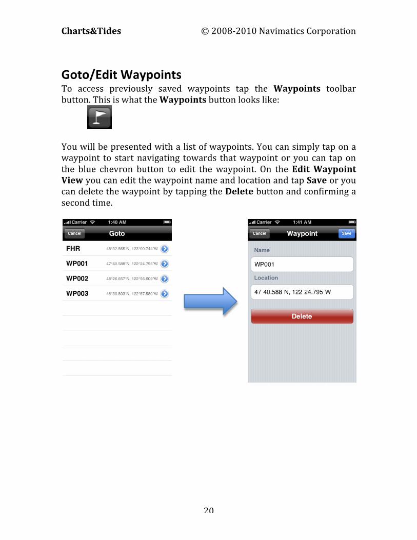
Goto/Edit Waypoints To access previously saved waypoints tap the Waypoints toolbar button. This is what the Waypoints button looks like:
You will be presented with a list of waypoints. You can simply tap on a waypoint to start navigating towards that waypoint or you can tap on the blue chevron button to edit the waypoint. On the Edit Waypoint View you can edit the waypoint name and location and tap Save or you can delete the waypoint by tapping the Delete button and confirming a second time.

Charts&Tides © 2008-‐2010 Navimatics Corporation
21
Waypoint Navigation Charts&Tides includes a navigation instrument called a Horizontal Situation Indicator (HSI). This instrument is usually found in aircraft and it can graphically display the vessel’s current track, desired track and cross-‐track error information. To show the HSI instrument press the PAGE button. Press the PAGE button again to hide the HSI instrument. The HSI instrument works as follows: The red arrow points to the current vessel track. The yellow arrow points to the current desired track. The body of the yellow arrow can deviate to the left or to the right. This graphically shows the current cross track error. Each yellow dot represents 1/5th of the Maximum HSI Deflection; the default Maximum HSI Deflection is 1.0M, but this can be changed in the Settings View. During waypoint navigation the objective is to keep the body of the yellow arrow centered. If the arrow body is moving to the left of its head you are deviating from your course to the right; to correct change your heading to move your vessel to the left. If the arrow body is moving to the right of its head you are deviating from your course to the left; to correct change your heading to move your vessel to the right.

Charts&Tides © 2008-‐2010 Navimatics Corporation
22
Red Arrow – Current Track
Yellow Arrow – Desired Track
Vessel
Yellow Arrow Body – “2.5 dots” deflection

Charts&Tides © 2008-‐2010 Navimatics Corporation
23
Distance To Wpt
Cross Track Error Velocity Made Good
Tap to access Settings ActiveCaptain
Integration
Information And Instruments To access the Information/Instruments View tap on the Information toolbar button. This button looks like this:
You will be presented with the following view:
You can tap on the Settings button to access the Settings View, which allows you to modify how Charts&Tides presents you with information. You can also tap on the ActiveCaptain button to instruct Charts&Tides to load ActiveCaptain data (see ActiveCaptain Integration).
Vessel Location
Vessel Speed Vessel Track
Current Waypoint
Desired Track
Bearing To Wpt
Press To Stop Wpt Navigation
Estimated Time Enroute

Charts&Tides © 2008-‐2010 Navimatics Corporation
24
Coloring Scheme For your Chart
Choose True or Magnetic Degrees
Sounding Units for your Chart
Clear Vessel’s Past Track
Show/Hide Vessel’s Past Track
Max Cross Track Error w/ full HSI
Deflection
Scroll up/down

Charts&Tides © 2008-‐2010 Navimatics Corporation
25
ActiveCaptain Integration Tapping on the ActiveCaptain button in the Information/Instruments View will present the ActiveCaptain Integration View. From here you can sign into ActiveCaptain and gain access to the Interactive Cruising Guidebook and the wealth of information that it provides. To sign into ActiveCaptain you must have an ActiveCaptain account. The ActiveCaptain service is completely free and is definitely worth your time to register. You can register at http://activecaptain.com. Once registered enter your credentials under Account and press the Update Now button to instruct Charts&Tides to update its local database with the ActiveCaptain data.
Show/Hide ActiveCaptain Markers
Frequency of update reminder
Enter ActiveCaptain Credentials
Tap to initiate update

Charts&Tides © 2008-‐2010 Navimatics Corporation
26
The first update can take a long time as much as 30-‐60 minutes on older devices. We recommend you perform this update over Wi-‐Fi because of the volume of data that must be downloaded. Subsequent updates should be done much faster. Once the update is complete you will have detailed information about thousands of marinas and anchorages, local knowledge and hazards not available on any chart.


