24
1 CHICAGO RIVER TRAIL ACTION PLAN

1
CHICAGO RIVER TRAIL ACTION PLAN

2
The OpportunityUrban waterfronts provide cities with unique possibilities for recreation, open space and transportation. Many world class cities have invested in developing waterfront parks and trails in order to connect residents with the myriad quality of life benefits they can bring, such as improved health, cleaner environments and economic opportunity.
While Chicago’s lakefront park and trail system is second to none, the Chicago River has not yet reached its full potential as a community recreation and active transportation asset.
A continuous Chicago River Trail system would help transform a neglected waterway into vibrant open space and an active transportation corridor connecting Chicago’s diverse neighborhoods to the river and to each other.
The VisionWe envision a seamless Chicago River Trail system that will provide a low-stress corridor for people walking, running and biking.
The Chicago River Trail will be made up of a diverse array of elements, including riverside, floating and decked trails, on-street connections and robust wayfinding. Building the trail structure on or over the water is key to expediting trail construction since riverside land is currently unavailable in places.
The Chicago River Trail will be accessed by a safe and comfortable network of streets designed to ensure people on foot, bike and transit have easy access to the river no matter their point of origin.
The Chicago River Trail will provide residents an opportunity to celebrate and embrace Chicago’s unique neighborhoods, its history and its diversity.
New sections of a riverwalk may be added along the river, such as this stretch between Bubbly Creek and Ashland Ave. Rendering courtesy of Great Rivers Chicago.
FRONT COVER Joining a continuous Chicago River Trail with the 606 Trail just south of West Cortland Street would provide a key connection. RENDERING CREDIT PORT Urbanism.
Cheonggyecheon is an urban park in Seoul, South Korea that restored a riverfront that had been buried by a highway. PHOTO CREDIT Flickr user Isageum

3
The HistoryThanks to relentless advocacy and bold leadership from residents, community organizations, government agencies and elected leaders, we are closer to achieving a continuous river trail than ever before.
The Chicago River has been a key transportation corridor for as long as people have lived in the region. As Chicago grew during the 19th Century, the river was a true working river, with industrial activity taking up prime riverfront space and limiting access to other users. We are still dealing with the environmental toll this activity took on the river, but after years of investment in remediation efforts, conditions are rapidly improving.
The idea of a continuous Chicago River Trail is not a new one. As far back as Daniel Burnham’s 1909 Plan of Chicago, concepts for riverfront promenades and other public spaces have been a part of the public discourse. In 1999, the Chicago Department of Planning and Development released the Chicago River Corridor Development Plan, which provided guidance for future development along the river. One of the key goals enumerated in this plan was the development of a continuous Chicago River Trail system.
As a part of the planning process, the city’s zoning code was updated to require new developments to include a 30-foot setback on the riverbank to allow for riverside access and trail development.
Since then, we have seen the construction of several riverfront trail segments ranging in size from the downtown Riverwalk to smaller parcels connected to individual developments. However, many of these segments are disconnected or inaccessible, demonstrating that relying on the 30-foot setback requirement alone may not be sufficient. Likewise, waiting for redevelopment of adjacent land parcels to construct new trail segments will delay the completion of a continuous river trail by decades.
In 2016, the Mayor Emanuel, in partnership with the Metropolitan Planning Council, Friends of the Chicago River, the Chicago Metropolitan Agency for Planning and dozens of other agencies and organizations released a new vision for Chicago’s rivers (the Chicago, Calumet and Des Plaines), called Our Great Rivers. The initiative included input gleaned from more than 6,000 individuals and 120 meetings. A continuous system of riverfront trails was identified as a top priority by stakeholders in all reaches of the river.
In some cases, the Chicago River Trail may take the form of neighborhood greenways — streets optimized for biking and walking. Rendering of proposed Manor Greenway courtesy of CDOT.

4
Why We Need a Chicago River TrailExperience in Chicago and in cities around the world has proven that investments in public spaces and infrastructure like a continuous Chicago River Trail would bring countless benefits, including:
• Promotion of active transportation, like biking and walking, which supports healthy communities, cleaner environments and a vibrant local economy.
• Improved and enhanced access to much-needed open space and recreation opportunities.
• Sustainable economic development through increased tourism, local retail and other economic sectors.
A Window of OpportunityNot only can we expect widespread benefits from a continuous Chicago River Trail, but we have a unique window of opportunity to advance this dream over the next few years.
• We are closer than you think. There are already 13.2 miles of trail along the Chicago River that are appropriate for both walking and biking. An additional 1.7 miles are slated for completion by the end of 2017.
• Chicagoans want more off-street trails. The long-term success of Chicago’s Lakefront Trail, as well as more recent projects like the 606 Trail, point to a latent demand for low-stress, off-street trails. More than 900,000 people live within one mile of the Chicago River and stand to benefit from access to a new trail system.
• We can leverage ongoing development. Multiple public and private projects are underway or slated to break ground along the Chicago River, such as the massive Riverline development as well as the Clark and Roosevelt developments in the South Loop, and the proposed Paseo project in Pilsen and Little Village. These provide immediate opportunities to develop several miles of new trail segments and improved access. Coordination, however, is required. It will be critical to ensure robust strategies are in place to avoid displacement within communities where new development is occurring.
• The money is out there. While Chicago and the State of Illinois face a tough fiscal landscape, the region has also proven an ability to leverage other sources of funding to finance these types of transformative projects, including federal grants, private donations, and creative financing strategies.
Numerous trail segments already exist along the Chicago River, including the Cherry Avenue Bridge segment on the northern tip of Goose Island. PHOTO CREDIT Anne Evans

5
• Convene stakeholder group to inform decisions and ensure community needs and concerns are addressed upfront.
• Inventory existing trail segments and access challenges.
• Develop design alternatives to overcome challenges presented by mixed land uses and limited rights-of-way.
• Identify and secure funding, including funding from federal programs, such as the Congestion Mitigation & Air Quality program.
• Continue efforts at environmental remediation and ecological restoration.
Local Action StepsThe Chicago River wends its way through a diverse array of neighborhoods and landscapes. From the far Northwest Side to the far Southwest Side, each segment of the river faces its own unique challenges and opportunities related to river trail development as well as safe access to and across the river.
Citywide Action Steps
New bridges and a wetland park in the river could unite Goose Island to the bustling retail and residential to its east. Rendering courtesy of Great Rivers Chicago.

6
ZONE 1: North Harlem Avenue east to North Cicero Avenue; West Touhy Avenue south to West Lawrence Avenue
Thanks to the recently extended North Branch Trail, Zone 1 has a strong existing river trail providing a regional connection to northern suburban communities. However, access to the river and the trail is limited from surrounding areas due to barriers such as highways, railroad embankments and a limited street network. Future improvements should prioritize creating low-stress connections between the river trail and key neighborhood destinations.
WARDS: 39, 41, 45
NEIGHBORHOODS: Edison Park, Norwood Park, Jefferson Park, Edgebrook, Wildwood, Forest Glen
DESTINATIONS: Edgebrook Metra Station, Forest Glen Metra Station, Jefferson Park Transit Center, Edgebrook and Sauganash retail districts, Lincolnwood Town Center, Forest Glen Woods Forest Preserve, Thaddeus “Ted” S. Lechowicz Woods Forest Preserve, Edgebrook Woods Forest Preserve, Wildwood Park, Edgebrook Park
LOCAL ACTION STEPS• Prioritize neighborhood greenway development to fill in
remaining gaps in trail segments and enhance access to river and trail from key destinations, such as the Jefferson Park Transit Center.
• Leverage excitement around new trail extension to engage residents, businesses and local decision makers.
BIG IDEA• Create a comprehensive network of neighborhood greenways,
including traffic calming and wayfinding signage, connecting existing trail network with local destinations and retail corridors.
EXISTING CONDITIONSRiver Trail: North Branch Trail extends from city limits to Gompers Park near West Foster Avenue and North Pulaski Road.
Access to River: On-street bike lanes on North Milwaukee and North Elston avenues provide bike access to the area from neighborhoods to the southeast.

7
MILWAUKEE
KENNEDY EXPRESSWAY
DEVON
FOSTER
EDEN
S EX
PRES
SWAY
CICE
RO
CALDWELL
TOUHY
LEHIGH
NORTHWEST HWY
LAWRENCE
ELSTON
BRYN MAWR
CEN
TRAL
HIGGINS
NAG
LE
HAR
LEM PETERSON
CREATE LOW-STRESSON-STREET CONNECTIONSTO RIVER
CREATE LOW-STRESS ON-STREETCONNECTIONS TO RIVER
JEFFERSON PARK TRANSITCENTER CONNECTION
WEBER SPURPROJECT
NORTH BRANCH TRAILCONTINUES
Planned and Existing Bikeways within One Mile Buffer of the Chicago River Trail
Existing On Street Bikeways
Existing Trails
Opportunity Areas
Planned/Proposed On-Street Bikeways
Planned/Proposed Trails
Chicago River | Zone 1

8
ZONE 2: North Cicero Avenue east to North Kedzie Avenue; West Devon Avenue south to West Lawrence Avenue
Zone 2 has several existing river trail segments. These segments can be easily linked together by a robust network of neighborhood greenways that could also be developed to improve access between the river and key neighborhood destinations.
WARDS: 30, 33, 35, 39
NEIGHBORHOODS: Sauganash, North Park, North Mayfair, Albany Park, North Park
DESTINATIONS: Sauganash retail district; Northeastern Illinois University; North Park University; Von Steuben High School; retail districts on Pulaski, Lawrence and Kedzie; North Park Village Nature Center; Senior Living Center; Peterson Park; Swedish Covenant Hospital; offices of WTTW
LOCAL ACTION STEPS• Create safe crossing across West Foster Avenue at terminus
of North Branch Trail extension.
• Identify priority on-street connections between existing segments and key destinations, such as east/west connection along West Bryn Mawr Avenue.
• Maintain or upgrade existing bike facilities and signage in the area.
• Move forward with plans to develop the Weber Spur Trail and improve low-stress connections.
EXISTING CONDITIONSRiver Trail: Segments are already complete along the North Branch Trail and North Channel Trail, including areas at Eugene Field Park and Kiwanis Park/Von Steuben Riveredge.
Access to River: North Kedzie Avenue has faded bike lanes north of the river, and they do not connect to the river.

9
Chicago River | Zone 2
Planned and Existing Bikeways within 1 Mile Buffer of the Chicago River Trail
Existing On Street Bikeways
Existing Trails
Opportunity Areas
Planned/Proposed On-Street Bikeways
Planned/Proposed Trails
Chicago River | Zone 2
MILWAUKEE
KENNEDY EXPRESSWAY
DEVON
FOSTER
EDEN
S EX
PRES
SWAY
CICE
RO
CALDWELL
TOUHY
NORTHWEST HWY
LAWRENCE
ELSTON
BRYN MAWR
CEN
TRAL
HIGGINS
AUST
IN
PETERSON
PRATT
MONTROSE
PULA
SKI
KEDZ
IE
KIM
BALL
WES
TERN
MCC
ORM
ICK
LINCOLN
JERSEY
BERTEAU
WILSON
NORTH SHORE CHAN
NEL
CALI
FORN
IA
DAM
EN
ASH
LAN
D
KEDZ
IE
DEVON
PRATT
NORTH CHANNEL TRAILBRIDGE CONNECTION
JEFFERSON PARK TRANSITCENTER CONNECTION
WEBER SPURPROJECT
DEVELOP LOW-STRESSON-STREET CONNECTIONSTO RIVER
RESTRIPE KEDZIEBIKE LANE
MANOR GREENWAYPROJECT
IMPROVE ON-STREETEAST/WEST CONNECTIONS
CREATE SAFETRAIL CROSSING
WEBER SPURPROJECT
CREATE LOW-STRESSON-STREET CONNECTIONSTO RIVER
TO SKOKIE VALLEYTRAIL
TO GREEN BAYTRAIL
Planned and Existing Bikeways within One Mile Buffer of the Chicago River Trail
Existing On Street Bikeways
Existing Trails
Opportunity Areas
Planned/Proposed On-Street Bikeways
Planned/Proposed Trails

10
ZONE 3: North Kedzie Avenue east to North Western Avenue; West Devon Avenue south to West Lawrence Avenue
The North Shore Channel Trail provides Zone 3 an excellent low-stress bike and pedestrian connection to Skokie and Evanston. The planned bike/pedestrian bridge at Lincoln Village will eliminate one of the remaining gaps in this trail network. Work remains to improve bike and pedestrian connections from surrounding neighborhoods and local streets.
WARDS: 33, 39, 50
NEIGHBORHOODS: Pulaski Park, Arcadia Terrace, Budlong Woods, Lincoln Square
DESTINATIONS: Ronan Park, River Park, Legion Park, North Side College Prep, Lincoln Square retail district, Swedish Covenant Hospital, Brown Line stations
EXISTING CONDITIONSRiver Trail: North Shore Channel trail provides regional connection from Evanston and Skokie south to West Lawrence Avenue.
Access to River:
• West Bryn Mawr Avenue has bike lanes east of river, but these need to be restriped.
• North Kedzie Avenue has bike lanes between West Bryn Mawr Avenue and West Foster Avenue, but these need to be restriped.
LOCAL ACTION STEPS• Build planned bridge across North Shore Channel at Lincoln
Village near West Hood Street.
• Restripe Kedzie bike lane from West Bryn Mawr Avenue to North Branch of the Chicago River.
• Identify priority east-west connections for neighborhood greenways and other improvements.

11
Chicago River | Zone 3
Planned and Existing Bikeways within One Mile Buffer of the Chicago River Trail
Existing On Street Bikeways
Existing Trails
Opportunity Areas
Planned/Proposed On-Street Bikeways
Planned/Proposed Trails
DEVON
FOSTER
TOUHY
LAWRENCE
BRYN MAWR
PETERSON
PRATT
PULA
SKI
KEDZ
IE
KIM
BALL
WES
TERN
MCC
ORM
ICK
LINCOLN
JERSEY
NORTH SHORE CHAN
NEL CA
LIFO
RNIA
DAM
EN
ASH
LAN
D
KEDZ
IE
CREATE LOW-STRESSON-STREET CONNECTIONSTO RIVER
DEVELOP LOW-STRESSON-STREET CONNECTIONSTO RIVER
WEBER SPURPROJECT
NORTH CHANNEL TRAILBRIDGE CONNECTION
RESTRIPE KEDZIEBIKE LANE
CREATE SAFETRAIL CROSSING
MANOR GREENWAYPROJECT
IMPROVE ON-STREETEAST/WEST CONNECTIONS
TO GREEN BAYTRAIL
“ Since taking office, I’ve worked to make our streets safer and bet-ter protect people biking and walking. Building a continuous trail along the Chicago River would be a game-changer by connecting popular destinations throughout the neighborhood and getting more people moving.”
33rd Ward Alderman Deb Mell

12
ZONE 4: West Lawrence Avenue south to West North Avenue; North Kedzie Avenue east to North Halsted Street
With several new trail segments in the works and a number of riverfront sites being redeveloped, Zone 4 is brimming with opportunity. There is an immediate window to influence river trail development, ensuring new segments connect to each other and to local streets and neighborhoods.WARDS: 1, 2, 32, 33, 47NEIGHBORHOODS: Ravenswood Manor, North Center, Avondale, Roscoe Village, Bucktown, Lincoln Park, Irving ParkDESTINATIONS: Horner Park, Lane Tech High School, Clark Park and nearby sports fields, Addison Industrial Corridor, Lathrop Homes, Lincoln Square shopping district, Clybourn/Halsted/North shopping district, DePaul University, 606 Trail, Clybourn Metra Station, CTA stations on Blue and Brown lines
LOCAL ACTION STEPS• Complete construction of planned projects, including Irving Park
Road Underbridge Path, Riverview Bridge and Manor Greenway.
• Leverage ongoing development at Lathrop Homes, Vienna Beef and Finkl Steel sites to complete new trail segments and improve access to the river trail through North Branch Industrial Corridor as part of Mayor Emanuel’s Industrial Corridor Modernization Initiative.
• Prioritize east/west bike and pedestrian connections, including improvements on West Belmont Avenue, West Logan Avenue/West Diversey Parkway, West Webster Avenue and West Cortland Avenue.
• Explore potential trail alternatives, including high-quality, grade separated bike path on West Cortland Street and North Kingsbury Street or floating trail segments.
• Create low-stress connection between 606 Trail and the river.
EXISTING CONDITIONSRiver Trail:• Several existing river trail segments will be connected in 2017
by new projects: – The Manor Greenway will create a low-stress on-street connection
between existing trail segments in Ronan and Horner Parks. – The Irving Park Road Underbridge Path will improve connections
between California and Horner Parks. • A trail segment exists through the Lathrop Homes development
from approximately West George Street south to West Wrightwood Avenue.
• Further south, land use patterns change to include more industrial and mixed-use developments, limiting opportunities for riverside trail development.
Access to River: The east/west bike and pedestrian access to the river in this zone is currently very poor. Bikeways on North Elston and North Clybourn avenues provide decent north/ south bicycle access to the area, but could be upgraded with more low-stress facilities.
BIG IDEA• Use floating trail segments to overcome gaps in trail due to
limited right of way or poor on-street connections.

13
Chicago River | Zone 4
LAWRENCE
CALI
FORN
IA
MONTROSE
IRVING PARK
ADDISON
BELMONT
DIVERSEY
FULLERTON
WEBSTER
NORTH
ARMITAGE
MILWAUKEE
KENNEDY EXPRESSWAYLINCOLN
KIM
BALL
KEDZ
IE
WES
TERN
DAM
EN
SOUT
HPO
RT
ASH
LAN
D
RACI
NE
SHEF
FIEL
D
HAL
STED
WEL
LS
CLYBOURN
NORTH
DAM
EN
ELSTON
GRACE
LARA
BEE
LAKE MICHIGAN
VIENNA BEEFREDEVELOPMENT
MANOR GREENWAYPROJECT
EXPLORE FLOATINGTRAIL CONCEPT
CONTINUE LOGAN BLVDBIKE LANE
FINKL STEEL REDEVELOPMENTIMPROVE CORTLAND BRIDGEFOR CYCLING
LATHROP HOMESREDEVELOPMENT
CREATE EAST/WESTBIKEWAY ON BELMONT
RIVERVIEWBRIDGE
IRVING PARKUNDERBRIDGE
606 EXTENSION
Planned and Existing Bikeways within One Mile Buffer of the Chicago River Trail
Existing On Street Bikeways
Existing Trails
Opportunity Areas
Planned/Proposed On-Street Bikeways
Planned/Proposed Trails
“ Preserving space along the river for public use is critical to growing and developing the city in a sustainable way. I’m excited about the potential for a continuous trail along the Chicago River to transform how people move around the neighborhood.”
32nd Ward Alderman Scott Waguespack
14
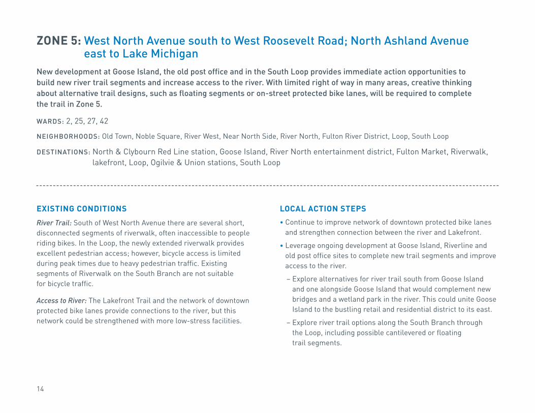
ZONE 5: West North Avenue south to West Roosevelt Road; North Ashland Avenue east to Lake Michigan
New development at Goose Island, the old post office and in the South Loop provides immediate action opportunities to build new river trail segments and increase access to the river. With limited right of way in many areas, creative thinking about alternative trail designs, such as floating segments or on-street protected bike lanes, will be required to complete the trail in Zone 5.
WARDS: 2, 25, 27, 42
NEIGHBORHOODS: Old Town, Noble Square, River West, Near North Side, River North, Fulton River District, Loop, South Loop
DESTINATIONS: North & Clybourn Red Line station, Goose Island, River North entertainment district, Fulton Market, Riverwalk, lakefront, Loop, Ogilvie & Union stations, South Loop
EXISTING CONDITIONS River Trail: South of West North Avenue there are several short, disconnected segments of riverwalk, often inaccessible to people riding bikes. In the Loop, the newly extended riverwalk provides excellent pedestrian access; however, bicycle access is limited during peak times due to heavy pedestrian traffic. Existing segments of Riverwalk on the South Branch are not suitable for bicycle traffic.
Access to River: The Lakefront Trail and the network of downtown protected bike lanes provide connections to the river, but this network could be strengthened with more low-stress facilities.
LOCAL ACTION STEPS• Continue to improve network of downtown protected bike lanes
and strengthen connection between the river and Lakefront.
• Leverage ongoing development at Goose Island, Riverline and old post office sites to complete new trail segments and improve access to the river.
– Explore alternatives for river trail south from Goose Island and one alongside Goose Island that would complement new bridges and a wetland park in the river. This could unite Goose Island to the bustling retail and residential district to its east.
– Explore river trail options along the South Branch through the Loop, including possible cantilevered or floating trail segments.

15
DIVISION
CHICAGO
ILLINOIS
WACKER
VAN BUREN
JACKSON
RANDOLPH
MONROE
CONGRESS
ROOSEVELT
BALBO
LAKE
EISENHOWER HARRISON
WASHINGTON
ONTARIOOHIO
NORTH
MILWAUKEE
ORLE
ANS
WEL
LS
DEAR
BORN
LASA
LLE
RUSH
COLU
MBU
S
LAKE
SHOR
E DR
IVE
CLAR
K
FRAN
KLIN
CAN
AL
CLIN
TON
JEFF
ERSO
N
DESP
LAIN
ES
HAL
STED
ADAMS
WAB
ASH
WAB
ASH
MIC
HIG
AN
MADISON
KENNEDY MIC
HIG
ANSTAT
E
CHICAGO RIVER
LAKE MICHIGAN
NORTH BRANCH
SOUTH BRAN
CH
GRAND
CHICAGO POST OFFICEDEVELOPEMENT
606 EXTENSION
RIVERLINEDEVELOPMENT
CLARK/ROOSEVELTREDEVELOPMENT
CONTINUE TO DEVELOPPROTECTED BIKE LANES
EXPLORE FLOATINGTRAIL CONCEPT
GOOSE ISLANDREDEVELOPMENT
EXPLORE FLOATINGTRAIL CONCEPT
Planned and Existing Bikeways within One Mile Buffer of the Chicago River Trail
Existing On Street Bikeways
Existing Trails
Opportunity Areas
Planned/Proposed On-Street Bikeways
Planned/Proposed Trails
“ Extending The 606 Bloomingdale Trail into the 2nd Ward and building a continuous Chicago River Trail are two of my top priorities. It’s critical we preserve public space along the river and provide safe and convenient routes for people to walk and bike throughout the city.”
2nd Ward Alderman Brian Hopkins
Chicago River | Zone 5

16
ZONE 6: West Roosevelt Road south to West 31st Street; North Ashland Avenue east to South State Street
Existing and planned riverside assets would benefit greatly from improved access from neighborhoods and connections along the river. Land use and barriers such as expressways present challenges, however, alternatives such as the development of the Paseo project and potential for on-street bikeways can help overcome these obstacles.
WARDS: 4, 11, 25, 42NEIGHBORHOODS: South Loop, Pilsen, Chinatown, BridgeportDESTINATIONS: Ping Tom Park, Palmisano Park, Eleanor Street Boathouse, Canal Origins Park, Chinatown
retail district, Pilsen retail district, Bubbly Creek, McCormick Place, lakefront
LOCAL ACTION STEPS• Leverage new development at South Clark Street and
West Roosevelt Avenue to complete new trail segments and improve river access.
• Move forward with plans to develop the Paseo.• Improve bike and pedestrian accommodations on South Halsted
Street and South Canal Street, especially on bridges.• Strengthen ped/bike connection between the river and
the lakefront along the West 18th Street corridor.• Create low-stress bike and pedestrian routes on
South Archer Avenue.• Include access and trail improvements in construction
of new segment of South Wells Street/South Wentworth Avenue.
• Create connection between east and west parts of Ping Tom Park and a second western entry point to the park.
EXISTING CONDITIONSRiver Trail: There are limited existing river trail segments in this zone. Ping Tom Park has paths that run near the river, however, access to surrounding streets is limited.
Access to River: Protected bike lanes on West 18th Street provide low-stress bike connection over the river. The new Eleanor Street Boathouse will provide new direct access point to the river.

17
Chicago River | Zone 6
ARCHER
COLUMBUS DR
ASH
LAN
D
DAM
EN
HAL
STED
CAN
AL
KENN
EDY EXPRESSWAY
DAN RYAN
EXPRESSWAY
STEVENSON
ROOSEVELT
18TH
CERMAK
PERSHING
35TH
STAT
E
CLAR
K
LOOM
IS
BLUE ISLAND
WEL
LS
26TH
31ST
MOR
GAN
MOR
GAN
RACI
NE
DR M
ARTI
N L
UTH
ER K
ING
MIC
HIG
AN
CHICAGO RIVER
LAKE MICHIGAN
PASEOPROJECT
CONNECT CANAL ORIGINS PARKTO ELEANOR BOATHOUSE
BRIDGEIMPROVEMENT
CREATE LOW-STRESSBIKEWAY ON ARCHER
WENTWORTH AVENUEEXTENSION
CLARK/ROOSEVELTREDEVELOPMENT
CANALPORT RIVERPARK IMPROVEMENTS
BRIDGEIMPROVEMENT
ENHANCE 18TH STCONNECTION TO LAKEFRONTIMPROVE ACCESS
AT PING TOM PARK
Planned and Existing Bikeways within One Mile Buffer of the Chicago River Trail
Existing On Street Bikeways
Existing Trails
Opportunity Areas
Planned/Proposed On-Street Bikeways
Planned/Proposed Trails

18
ZONE 7: South Ashland Avenue west to South Cicero Avenue; West Cermak Road south to South Archer Avenue
The development of the Paseo will provide a low-stress walking and biking space near the river, but it will be important to ensure the project reflects community desires and concerns. A challenge is presented by connecting the planned terminus of the Paseo southwest to the city limits, but this also presents a great opportunity to create a regional connection when the I&M Trail is extended northwest to Chicago’s borders.
WARDS: 11, 12, 14, 22, 25
NEIGHBORHOODS: Pilsen, McKinley Park, Little Village, Brighton Park, Archer Heights
DESTINATIONS: La Villita Park, Richard J. Daley Boat Launch, Ashland Orange Line, Pilsen Industrial Corridor, McKinley Park, Benito Juarez Academy
LOCAL ACTION STEPS• Move forward with plans to develop the Paseo.
• Improve bike and pedestrian access on bridges crossing river, especially at South Western and South Kedzie avenues.
• Assess feasibility of converting an unused segment of CN Railway along the north side of the Sanitary & Ship Canal between West 31st Boulevard and South Central Park Avenue into a public trail facility.
• Complete Streets for Cycling 2020 Spoke Route on South Archer Avenue.
EXISTING CONDITIONSRiver Trail: The only existing river trail segment in this zone is at Canalport River Park.
Access to River: Given the heavy industrial presence in this zone, access to the river is challenging. Likewise, none of the existing bridges crossing the river in this zone have acceptable bicycle or pedestrian access. However, it may be possible to convert an unused but grade separated segment of CN Railway along the north side of the Sanitary & Ship Canal between West 31st Boulevard and South Central Park Avenue (1.5 miles) into a public trail facility. The west end of this corridor connects with the west end of the Paseo corridor, and the east end connects with Chicago’s historic boulevard system.
BIG IDEAS• Our Great Rivers: Create new park space and river trail at the Collateral
Channel on the north bank. Connect Canal Origins Park to Eleanor Street Boathouse with bridge over Bubbly Creek.
• Create regional low-stress bikeway connection by linking I&M trail to Chicago River Trail.

19
PULA
SKI
35TH
26TH
CERMAK
BLUE ISLAND
KEDZ
IE
WES
TERN
SANITARY SHIP CANAL
DAM
EN
ASH
LAN
D
LOOM
IS
HAL
STED
ARCHER
31TH
35TH
PERSHINGCALI
FORN
IA
STEVENSON EXPRESSWAY
ROOSEVELT
18TH
PASEOPROJECT
DECK OVERCOLLATERAL CHANNEL
BRIDGEIMPROVEMENT
CONTINUE LOW-STRESSBIKEWAY ON ARCHER
CREATE LOW-STRESSBIKEWAY ON ARCHER
IMPROVE WESTERN AVEBRIDGE FOR PEDS AND BIKES
CANALPORT RIVERPARK IMPROVEMENTS
IMPROVE KEDZIE AVE BRIDGEFOR PEDS AND BIKES
CONNECT ORIGIN PARK TOELEANOR BOATHOUSE
TO I&M CANAL TRAIL
Chicago River | Zone 7
Planned and Existing Bikeways within One Mile Buffer of the Chicago River Trail
Existing On Street Bikeways
Existing Trails
Opportunity Areas
Planned/Proposed On-Street Bikeways
Planned/Proposed Trails

20
TRADITIONAL RIVER EDGE TRAILCommonly seen along the North Branch of the Chicago River, a traditional river edge trail uses land along the bank of the river for a conventional multi-use path. Where space is available, this is a preferred option. However, given the limited right of way and diverse land use along much of the Chicago River, there may not be many opportunities to implement this design unless new development happens.
Trail Design Options
FLOATING TRAILFloating trail systems exist in several US cities, including Portland, Oregon and Philadelphia, Pennsylvania. Like decked trails, floating segments provide a good alternative where no land is available for a traditional trail segment.
DECKED TRAILRather than use land adjacent to the river, a decked trail is constructed over the river on pylons. This is a good alternative for connecting existing segments, such as in the Riverview Bridge project, which is scheduled for completion in 2017.
RENDERING CREDIT CDOT/Epstein Riverview Bridge
RENDERING CREDIT Eckenhoff Saunders Architects

21
ON-STREET CONNECTIONSIn some instances, a trail along the river may not be feasible in the near term. In these situations, high-quality on-street connections between river trail segments should be considered.
• Neighborhood greenways are typically found on residential streets optimized for walking and biking through a combination of treatments, such as traffic calming and wayfinding signage. The planned Manor Greenway project is an example of a neighborhood greenway that will support the river trail system.
• Protected or separated bikeways provide safe and comfortable space for biking on busier arterial streets by creating physically separated space for people biking. They also improve the pedestrian experience by providing a buffer between people walking and fast moving cars. Chicago has a robust and growing network of protected bike lanes. Redevelopment along streets such as West Cortland Street provides opportunities to improve access to the river trail system through protected bike lanes and other roadway treatments.
The concessions and beautifully designed space makes the newly completed downtown Riverwalk a very desirable destination.RENDERING CREDIT CDOT
“ I’ve prioritized investments in biking, walking and public transit because my constituents are demanding safer and more convenient transportation options. Like The 606, a Chicago River Trail would get more people biking and walking and connect diverse neighborhoods throughout the city.”
1st Ward Alderman Joe Moreno

22
Moving Forward: Our Advocacy StrategyWith so many different challenges and opportunities shaping the course of Chicago River Trail development, a coordinated advocacy effort will be required to ensure community voices are heard and progress is made.
1. Build consensus – working in partnership with key community and public stakeholders, we will build consensus on the vision for a continuous Chicago River Trail.
2. Identify priorities – using this consensus as a guide, we will establish priorities to focus our advocacy efforts on immediate opportunities to drive Chicago River Trail development forward.
3. Establish coalition – based off of these priorities, we will organize our allies and grassroots supporters to push this agenda forward.
4. Mobilize support – using diverse advocacy tactics, we will work to directly influence Chicago River Trail development and drive progress towards the ultimate goal of a seamless trail system.
A rendering of the of the 606 Trail connecting with a Chicago River Trail.
1. The 606 Trail2. Underpass beneath Kennedy Expressway3. ADA ramp over railway tracks4. Overlook towards downtown skyline5. Slope down to join disused railway track6. New bridge splits around old swing bridge overlook7. New bridge frames old swing bridge
8. River Trail north 9. River Trail south10. River-oriented public space11. River-oriented mixed-use development12. Seating steps13. Boat docks + kayak launches
RENDERING CREDIT PORT Urbanism

23
AcknowledgementsActive Trans Project TeamJim MerrellHeather SchadyTed VillaireJacque Henrikson
Graphic Design: Anne Evans
Cover Image: PORT Urbanism
Special Thanks to Great Rivers Chicago partners: City of Chicago, Metropolitan Planning Council, Friends of the Chicago River, and Chicago Metropolitan Agency for Planning
Learn more about Great Rivers Chicago at greatriverschicago.com
Thank you to Richard H. Driehaus Foundation for its generous support of this report.
Thomas Applegate – North River CommissionMiguel Cambray – Enlace ChicagoSarah Cardona – Metropolitan Planning CouncilNelson Cheung – Chicago Department of Planning and DevelopmentDuka Dabovic – North River CommissionAndrew Donakowski – Friends of the Chicago RiverJosh Ellis – Metropolitan Planning CouncilVeronica Gonzalez – Resurrection ProjectJuanita Irizarry – Friends of the ParksDebbie Liu – Coalition for a Better Chinese
American CommunityAdam Lund – Perkins & WillKelly Murphy – Hoerr SchaudtMatt Nardella – Moss DesignKara Riggio – Metropolitan Planning CouncilTodd Snapp – Perkins & WillMichelle Stenzel – Bike Walk Lincoln ParkSharon Wheeler – Near North Unity ProjectAndrew Vesselinovitch – Ross Barney Architects
Thank you to the following individuals for providing input on this report:

24
9 W. Hubbard Street | Suite 402 | Chicago, Illinois 60654 | activetrans.org
CHICAGORIVER TRAIL ACTION PLAN
This report was made possible by the generous support of the Richard H. Driehaus Foundation.


