ALLEGANY COUNTY 01 Dan’s Mountain WMA 240 Warrior Mountain WMA 241 Green Ridge SF 242 Billmeyer WMA 243 Rocky Gap SP 244 Belle Grove WMA 245 Sideling Hill WMA 246 McCoole Fishery Management Area 247 ANNE ARUNDEL COUNTY 02 Davidsonville Receiver Station 424 Fort Meade 425 Smithsonian 427 Crownsville CWMA 428 BALTIMORE COUNTY 03 Prettyboy Watershed 340 Liberty Watershed 341 Loch Raven Watershed 342 Gunpowder SP 343 Patapsco SP 344 Gwynnbrook WMA 345 Soldiers Delight NEA 346 CALVERT COUNTY 04 Parkers Creek WMA 454 Calvert Cliffs SP 455 Flag Pond CWMA 456 Huntingtown Area 457 Biscoe Gray Heritage Farm CWMA 458 Hall Creek NRMA 459 CAROLINE COUNTY 05 Idylwild WMA 525 Tuckahoe SP 526 Chesapeake Forest Lands 527 CARROLL COUNTY 06 Morgan Run NEA 314 Liberty Watershed 315 Hanover Watershed 316 Sawmill-Speigel CWMA 317 Patapsco SP 319 Avondale WMA 630 Woodbrook CWMA 632 Maring CWMA 633 Hahn CWMA 634 CECIL COUNTY 07 Elk Neck SP 360 Elk Neck SF 361 C&D Canal Lands 362 Earleville WMA 363 Fair Hill NRMA 364 Grove Farm WMA 366 Old Bohemia WMA 367 CHARLES COUNTY 08 Riverside WMA 395 Chapman SP (Mt. Aventine) 397 Nanjemoy WMA 398 Cedar Point WMA 399 Indian Head Naval Ordinance Area 400 Myrtle Grove WMA 401 Doncaster SF or Tayloes Neck 402 Chapel Point SP 403 Nanjemoy Creek WMA 404 Cedarville SF 405 Indian Creek NRMA 406 Chicamuxen WMA 407 DORCHESTER COUNTY 09 LeCompte WMA 540 Linkwood WMA 541 Fishing Bay WMA 542 Blackwater NWR 543 Taylor’s Island WMA 544 Chesapeake Forest Lands 545 FREDERICK COUNTY 10 Frederick City Watershed 280 Gravel Hill Swamp WMA 280 Ridenour Swamp WMA 280 Cunningham Falls SP, Thurmont WS 281 Monocacy NRMA 282 South Mountain SP 283 Emmitsburg Watershed 284 Heaters Island WMA 286 Urbana Fishery Management Area 287 GARRETT COUNTY 11 Savage River SF 220 Potomac SF 221 Garrett SF 222 Mount Nebo WMA 223 Deep Creek Lake SP 224 Youghiogheny Reservoir 225 Frostburg Watershed 227 Cunningham Swamp WMA 228 HARFORD COUNTY 12 Rocks SP 325 Aberdeen Proving Ground 326 Gunpowder SP 327 Susquehanna SP 328 Stoney Demonstration Forest 329 HOWARD COUNTY 13 Hugg-Thomas WMA 415 Patuxent River SP 416 Patapsco SP 417 Triadelphia/Rocky Gorge (WSSC) 604 KENT COUNTY 14 Millington WMA 375 Eastern Neck NWR 376 Sassafras NRMA 378 MONTGOMERY COUNTY 15 Patuxent River SP 440 Mckee-Beshers WMA 441 Seneca Creek SP 442 Cherrington CWMA 443 Strider WMA 444 Islands of the Potomac 445 Triadelphia/Rocky Gorge (WSSC) 447 Seneca Schaeffer Farm Tract 625 PRINCE GEORGE’S COUNTY 16 Belt Woods NEA 476 Gardner Road Park CWMA 477 Cheltenham WMA 478 Aquasco Farms CWMA 480 Spice Creek (Patuxent River) NRMA 481 Mill Town Landing NRMA 482 Nottingham NRMA 483 Beltsville 484 Rosaryville SP 485 Brandywine Receiver Station 486 Patuxent WRC (Central Tract) 487 Billingsley Tract (Patuxent River Park) 488 Triadelphia/Rocky Gorge (WSSC) 489 QUEEN ANNE’S COUNTY 17 Tuckahoe SP 390 Wye Island NRMA 391 ST. MARY’S COUNTY 18 Newtowne Neck SP 462 St. Inigoes SF 463 Point Lookout SP (Jacobs Property) 464 Patuxent Naval Air Station 465 Elm’s CWMA 466 St. Mary’s SP or Salem Tract 467 Historic St. Mary’s City CWMA 468 Greenwell SP 469 Myrtle Point CWMA 600 SOMERSET COUNTY 19 Deal Island WMA 500 Fairmount WMA 501 Cedar Island WMA 503 Pocomoke Sound WMA 504 Maryland Marine Properties WMA 505 Wellington WMA 506 South Marsh Island WMA 507 Chesapeake Forest Lands 508 TALBOT COUNTY 20 Seth CFL 515 WASHINGTON COUNTY 21 Indian Springs WMA 260 Sideling Hill WMA 261 South Mountain SP 262 Hagerstown Watershed 263 W. Maryland Ag. Research Station (B) 264 Greenbrier SP 265 Fort Frederick SP 266 Woodmont 267 Maryland Correctional Training Center 268 Prather’s Neck WMA 269 WICOMICO COUNTY 22 Wetipquin WMA 554 Ellis Bay WMA 555 Wicomico Demo Forest CFL 556 Johnson WMA 557 Nanticoke WMA 558 Chesapeake Forest Lands 559 WORCESTER COUNTY 23 Pocomoke SF 580 E.A. Vaughn WMA 581 Hickory Point 582 Pocomoke River WMA 583 Isle of Wight WMA 584 Assateague NS 585 Chesapeake Forest Lands 586 Assateague SP 700 PUBLIC LAND CODES BY COUNTY How to Use These Maps • Maryland counties and their respective Private Land Codes are dis- played geographically on pgs. 34-36. • A table listing of Public Land Codes by county is located on this page. • The Chronic Wasting Disease Management Area now includes all of Allegany County and the western portion of Washington County that includes Private Land Code 250. A Public or Private Land Code is Required for Checking Your Deer or Turkey. DEER AND TURKEY TAGGING & CHECKING Chronic Wasting Disease Management Area Boundary Description The Maryland CWDMA includes all of Allegany County and Harvest Management Unit 250 in western Washington County. • Eastern Boundary: I-70 from the Maryland/ Pennsylvania border south to Rt. 522, then south on Rt. 522 to the Maryland/West Virginia border. • Southern Boundary: The Maryland/West Virginia border from Rt. 522 west to the Allegany/Garrett County line. • Western Boundary: The Allegany/Garrett County line from the Maryland/West Virginia border north to the Maryland/Pennsylvania border. • Northern Boundary: The Maryland/ Pennsylvania border from the Allegany/Garrett County line east to I-70.
Transcript
ALLEGANY COUNTY 01Dan’s Mountain WMA 240Warrior Mountain WMA 241Green Ridge SF 242Billmeyer WMA 243Rocky Gap SP 244Belle Grove WMA 245Sideling Hill WMA 246McCoole Fishery Management Area
247
ANNE ARUNDEL COUNTY 02Davidsonville Receiver Station 424Fort Meade 425Smithsonian 427Crownsville CWMA 428
CHARLES COUNTY 08Riverside WMA 395Chapman SP (Mt. Aventine) 397Nanjemoy WMA 398Cedar Point WMA 399Indian Head Naval Ordinance Area
400
Myrtle Grove WMA 401Doncaster SF or Tayloes Neck 402Chapel Point SP 403Nanjemoy Creek WMA 404Cedarville SF 405Indian Creek NRMA 406Chicamuxen WMA 407
DORCHESTER COUNTY 09LeCompte WMA 540Linkwood WMA 541Fishing Bay WMA 542Blackwater NWR 543Taylor’s Island WMA 544Chesapeake Forest Lands 545
FREDERICK COUNTY 10Frederick City Watershed 280Gravel Hill Swamp WMA 280Ridenour Swamp WMA 280Cunningham Falls SP, Thurmont WS
281
Monocacy NRMA 282South Mountain SP 283Emmitsburg Watershed 284Heaters Island WMA 286Urbana Fishery Management Area
287
GARRETT COUNTY 11Savage River SF 220Potomac SF 221Garrett SF 222Mount Nebo WMA 223Deep Creek Lake SP 224Youghiogheny Reservoir 225Frostburg Watershed 227Cunningham Swamp WMA 228
HARFORD COUNTY 12Rocks SP 325Aberdeen Proving Ground 326
HOWARD COUNTY 13Hugg-Thomas WMA 415Patuxent River SP 416Patapsco SP 417Triadelphia/Rocky Gorge (WSSC)
604
KENT COUNTY 14Millington WMA 375Eastern Neck NWR 376Sassafras NRMA 378
MONTGOMERY COUNTY 15Patuxent River SP 440Mckee-Beshers WMA 441Seneca Creek SP 442Cherrington CWMA 443Strider WMA 444Islands of the Potomac 445Triadelphia/Rocky Gorge (WSSC)
447
Seneca Schaeffer Farm Tract 625PRINCE GEORGE’S COUNTY 16
Belt Woods NEA 476Gardner Road Park CWMA 477Cheltenham WMA 478Aquasco Farms CWMA 480Spice Creek (Patuxent River) NRMA
481
Mill Town Landing NRMA 482Nottingham NRMA 483Beltsville 484Rosaryville SP 485Brandywine Receiver Station 486Patuxent WRC (Central Tract) 487Billingsley Tract (Patuxent River Park)
488
Triadelphia/Rocky Gorge (WSSC)
489
QUEEN ANNE’S COUNTY 17Tuckahoe SP 390Wye Island NRMA 391
ST. MARY’S COUNTY 18Newtowne Neck SP 462St. Inigoes SF 463Point Lookout SP (Jacobs Property)
464
Patuxent Naval Air Station 465Elm’s CWMA 466St. Mary’s SP or Salem Tract 467Historic St. Mary’s City CWMA 468Greenwell SP 469Myrtle Point CWMA 600
SOMERSET COUNTY 19Deal Island WMA 500Fairmount WMA 501Cedar Island WMA 503Pocomoke Sound WMA 504Maryland Marine Properties WMA
505
Wellington WMA 506South Marsh Island WMA 507Chesapeake Forest Lands 508
TALBOT COUNTY 20Seth CFL 515
WASHINGTON COUNTY 21Indian Springs WMA 260Sideling Hill WMA 261South Mountain SP 262Hagerstown Watershed 263W. Maryland Ag. Research Station (B)
264
Greenbrier SP 265Fort Frederick SP 266Woodmont 267Maryland Correctional Training Center
WORCESTER COUNTY 23Pocomoke SF 580E.A. Vaughn WMA 581Hickory Point 582Pocomoke River WMA 583Isle of Wight WMA 584Assateague NS 585Chesapeake Forest Lands 586Assateague SP 700
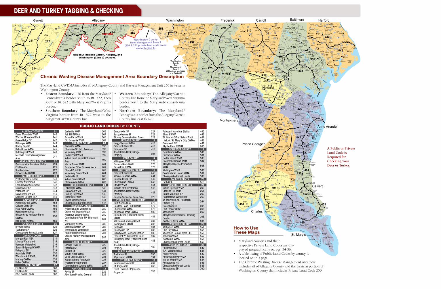
PUBLIC LAND CODES BY COUNTY
How to Use These Maps
• Maryland counties and their respective Private Land Codes are dis-played geographically on pgs. 34-36.
• A table listing of Public Land Codes by county is located on this page.
• The Chronic Wasting Disease Management Area now includes all of Allegany County and the western portion of Washington County that includes Private Land Code 250.
A Public or Private Land Code is Required for Checking Your Deer or Turkey.
DEER AND TURKEY TAGGING & CHECKING
Chronic Wasting Disease Management Area Boundary Description
The Maryland CWDMA includes all of Allegany County and Harvest Management Unit 250 in western Washington County.• Eastern Boundary: I-70 from the Maryland/
Pennsylvania border south to Rt. 522, then south on Rt. 522 to the Maryland/West Virginia border.
• Southern Boundary: The Maryland/West Virginia border from Rt. 522 west to the Allegany/Garrett County line.
• Western Boundary: The Allegany/Garrett County line from the Maryland/West Virginia border north to the Maryland/Pennsylvania border.
• Northern Boundary: The Maryland/Pennsylvania border from the Allegany/Garrett County line east to I-70.
dnr.maryland.gov 37
How to Use These Maps
• Maryland counties and their re-spective Private Land Codes are
displayed geographically on pgs. 34-36.
• A table listing of Public Land Codes by county is located on pg. 34.
Federal Migratory Game Bird Hunting Regulations can be viewed at: dnr.mary-land.gov/wildlife/Hunt_Trap/pdfs/MGB_FederalHuntingRegs.pdf
Offshore Waterfowl Hunting Rules & Regulations (offshore duck blinds, sea duck and offshore waterfowl hunting zones) can be viewed at: dnr.maryland.gov/wildlife/Pages/hunt_trap/offshore_intro.aspx
General Migratory Game Bird Hunting Rules
• Migratory game birds may not be hunted on Sundays.
• A hunter must carry personal photo identification (such as driver’s license) or a secondary form of identification while hunting.
• Written permission is required to hunt on private land.
• A hunting license is required to hunt migratory game birds in Maryland (with exceptions). See Maryland Hunting Licenses (pgs. 54-57) for requirements, types, costs, exceptions, purchasing, and Armed Forces information.
• A Maryland Migratory Game Bird Stamp is required of all hunters to hunt all migratory game birds in Maryland. This includes persons not required to have a hunting license and holders of senior hunting licenses. » This stamp may be obtained through
the COMPASS portal at compass.dnr.maryland.gov/ OR any DNR Licensing and Registration Service Center (pg. 6) OR a DNR Sport License agent.
» While hunting migratory game birds, hunters must possess the printed validation showing proof of purchase of the Maryland Migratory Game Bird Stamp and Harvest Information Program (HIP) certification.
» Hunters are not required to possess or sign the actual stamp.
Maryland Migratory Game Bird Stamp ������������������������������� $9�00 (See Purchasing Your Maryland Hunting Licenses, Stamps and Permits, pg 57.)
• A Federal Migratory Bird Hunting and Conservation Stamp (federal duck stamp) is required of all hunters over the age of 15 to hunt brant, coots, ducks, and geese in Maryland. This includes persons not required to have a hunting license. (See Who May Hunt Without a License pg. 56). » This stamp may be purchased from
National Wildlife Refuges, Post Offices, online at duckstamp.com and through the COMPASS portal at compass.dnr.maryland.gov/ OR any DNR Licensing and Registration Service Center (pg. 6) OR a DNR Sport License agent.
» If you order your federal duck stamp online (duckstamp.com), you will receive a purchase code. If you purchase your stamp through COMPASS, a DNR sport license agent, DNR online licensing, or a DNR Licensing and Registration Center, you will receive a printed validation showing proof of pur-chase. Both the purchase code and the validation will be accept-ed as proof of the purchase for 45 days, and must be possessed while hunting waterfowl and coots. The paper stamp will be mailed to the purchaser.
» The proof of purchase will expire after 45 days after which the pur-chaser must possess the stamp, signed in ink, while hunting wa-terfowl and coots.
» This stamp must be signed in ink but does not have to be attached to the hunting license.
» If you do not receive your federal duck stamp within 2-3 weeks after purchase from DNR online or by phone, please email [email protected] or call 1-800-852-4897.
Federal Migratory Bird Hunting and Conservation StampAt National Wildlife Refuges, U�S� Post Offices and at duckstamp.com ����������������������� $25�00
From the COMPASS portal at compass.dnr.maryland.gov/ OR any DNR Licensing and Registration Service Center (pg� 6) OR a DNR Sport License agent ����������������������������$27�00
• A Harvest Information Program (HIP) Certification is required of all hunters to hunt all migratory game birds in Maryland. The certification is free and issued with the Maryland Migratory Game Bird Stamp.
• Hunters must have the the printed vali-dation showing proof of purchase of the Maryland Migratory Game Bird Stamp and HIP certification in their possession while hunting migratory game birds.
• When you purchase your Maryland Migratory Game Bird Stamp, you will be asked the following HIP questions that are used for harvest survey sam-pling only: » Do you plan to hunt brant this com-
ing hunting season? » About how many ducks, geese,
doves, and woodcock did you bag last season?
» Did you hunt sea ducks (eiders, long-tailed duck and scoters), coots, snipe or rails last season?
• A Maryland Snow Goose Conservation Order Hunting Season Permit is re-quired to participate in the Light Goose Conservation Order Season. Hunters must possess the printed validation showing proof of the purchase of this permit while hunting. (See Light Goose Seasons & Bag Limits pg. 40.)
Snow Goose Conservation Order Hunting Season Permit ������������������������������������� $5�00(See Purchasing Your Maryland Hunting Licenses, Stamps and Permits, pg 57.)
• A Regulated Shooting Area Hunting License allows you to shoot only cap-tive-raised game birds on a state-licensed
DEER AND TURKEY TAGGING & CHECKING MIGRATORY GAME BIRD HUNTING
Migratory Game Birds are: brant, coots, doves, ducks, geese, rails, snipe, and woodcock. Brant, ducks, and geese are referred to as waterfowl.
Canada Goose Seasons .........................................................................................pg. 38 September Teal Season ..........................................................................................pg. 38Youth Waterfowl Hunting Days...............................................................................pg. 39Regular Duck Season .............................................................................................pg. 39Sea Duck Zone Season ...........................................................................................pg. 40Brant Season ..........................................................................................................pg. 40Light Goose Seasons ..............................................................................................pg. 40Dove, Woodcock, Rails, & Snipe Seasons ......................................................pgs. 40-41Extended Falconry Seasons ...................................................................................pg. 41Migratory Game Bird Hunting Rules & Regulations ..............................................pg. 42Migratory Game Bird Hunting Devices Rules & Regulations ................................pg. 43
Talbot County
Dorchester County
Sections of Frederick and Worcester counties, continued from page 11.
Breech-loading rifles may not be used to hunt deer in:• That section of Frederick County located west of the Monocacy River beginning
where Fingerboard Road crosses the river, then by and with the west side of the Monocacy River to the crossing by Biggs Ford Road, then by and with the south side of Biggs Ford Road to the junction with Route 15, then by and with the west side of Route 15 to the junction with Sundays Lane, then by and with the south side of Sundays Lane to the junction with Bloomfield Road, then by and with the east side of Bloomfield Road to the junction with Opossumtown Pike, then by and with the south side of Opossumtown Pike to the junction with Walter Martz Road, then by and with the east side of Walter Martz Road to the junction with Christopher’s Crossing, then by and with the south side of Christopher’s Crossing to the junction with Rocky Springs Road, then by and with the south and east side of Rocky Springs Road to the junction with Kemp Lane, then by and with the east side of Kemp Lane to the junction with Shookstown Road, then by and with the north side of Shookstown Road to the junction with Bowers Road, then by and with the east side of Bowers Road to the junction West Patrick Street, then by and with the north side of West Patrick Street to the junction with Blentlinger Road, then by and with the east side of Blentlinger Road to the junction with Old National Pike, then by and with the south side of Old National Pike to the junction with Maryland Interstate 70, then by and with the north side of Maryland Interstate 70 to the junction with Route 15, then by and with the east side of Route 15 to the junction with Mt. Zion Road, then by and with the north side of Mt. Zion Road to the junction with Elmer Derr Road, and then by and with the north side of Elmer Derr Road to the junction with New Design Road, then by and with the east side of New Design Road to the junction with Manor Woods Road, then by and with the north side of Manor Woods Road to the junction with Buckystown Pike, then by and with the east side of Buckystown Pike to the junction with Fingerboard Road, and then by and with the north side of Fingerboard Road to the crossing over the Monocacy River.
• Those sections of Worcester County as follows: » within one mile of any school; » within that portion of South Point lying south of a line beginning at the west
end of the Sinepuxent Bay Bridge on State Rt. 611, then by and with the south side of Rt. 611 to the junction of the South Point Road going south for a distance of 0.6 miles to a point opposite the southern boundary of the Ocean City Golf and Yacht Club property on the west side of the road, then by the southern boundary of the Ocean City Golf and Yacht Club to Trappe Creek; and
» within that portion of the land lying south of a line beginning at the mouth of the St. Martin River northwest to the junction with Shingle Landing Road, then by and with the south side of Shingle Landing Road to the junction with State Rt. 113, then by and with the east side of Rt. 113 to the junction with Rt. 589, then by and with the east side of Rt. 589 to the junction with US Rt. 50, then by and with the north side of Rt. 50 to the junction with Assawoman Bay, then by and with the west boundary of Assawoman Bay to the junction with the St. Martin River.
See map on page 11 for all shotgun and rifle counties/areas.