OSTEEN LOCAL PLAN LARGE-SCALE COMPREHENSIVE PLAN AMENDMENT STAFF REPORT April 2009 Prepared by: City of Deltona Planning and Development Services Department And Volusia County Growth and Resources Management Department
Transcript
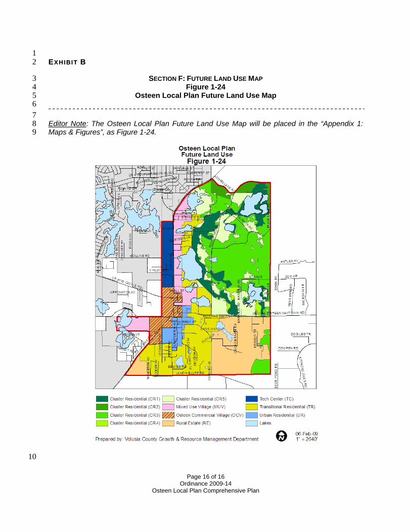
OSTEEN LOCAL PLAN LARGE-SCALE COMPREHENSIVE PLAN AMENDMENT
STAFF REPORT
April 2009
Prepared by:
City of Deltona Planning and Development Services Department
And
Volusia County Growth and Resources Management Department
OSTEEN LOCAL PLAN STAFF REPORT
1
I. SUMMARY: Applicant: Volusia County and City of Deltona Amendment Name: Osteen Local Plan Acres: Approximately 3,990 Acres General Location: Generally encompasses the Osteen community which is
located within the south central area of the County adjacent to the southeast side of the City of Deltona approximately 2 ½ miles north of the Volusia/Seminole County line.
Current Future Land Use: Agricultural Resource (AR), Commercial (C), Environmental Systems Corridor (ESC), Forestry Resource (FR), Low Impact Urban (LIU), Natural Resource Management Area (NRMA), Public/Semi-Public (P), Rural (R), Urban Low Intensity (ULI), and Urban Medium Intensity (UMI)
Proposed Future Land Use: Osteen Local Plan specific categories: Osteen Commercial Village (OCV), Mixed Use Village (MUV), Tech Center (TC), Urban Residential (UR), Transitional Residential (TR), Cluster Residential (CR), and Rural Estate (RE)
II. OVERVIEW: Beginning in February 2006, the elected officials for the City of Deltona and the County initiated the Osteen Joint Planning Area process to proactively plan for the anticipated growth within the area. This process involved:
• Conducting a survey of residents within the study area and up to a three-mile radius outside of the Osteen JPA on planning related issues;
• Collecting and assessing demographic and economic related data; and • Initiating land use studies.
On August 30, 2007, the City and County held their final joint public participation planning meeting and agreed to the basics of the next steps. The elected officials directed their respective staff to work together to finalize the land use plan and develop a framework for implementing the plan. A matrix for each of the proposed future land use designations was developed, including a description, associated intensity/density standards, and conceptual design guidelines/criteria for each designation. The final plan was presented to both jurisdictions and approved in February 2008 at which time staffs were directed to draft a Joint Planning Agreement to implement the agreed upon plan. On December 5, 2008 the Joint Planning Agreement was executed by Deltona City Commission and Volusia County Council. The joint planning agreement provides for the development of specific land development standards that each jurisdiction will adopt to implement the Local Plan and establishes ground rules for future amendments to the Local Plan. The proposed future land use designations and the goals, objectives and policies of this amendment are unique for the Osteen Local Plan and are the result of the multi-year planning process between the jurisdictions. This staff report and referenced attachments serve as the supporting data and analysis for the Osteen Local Plan. The staff report was mutually prepared by the staff of the City of Deltona and Volusia County. Once adopted, the land use descriptions, Future Land Use Map (FLUM), and the
OSTEEN LOCAL PLAN STAFF REPORT
2
goal, objectives, and policies for the Osteen Local Plan will be incorporated in the City and County Comprehensive Plans. Although the formatting and/or numbering will be different, the text and FLUM for the Osteen Local Plan will be identical within each jurisdiction’s Comprehensive Plan. The transmittal hearing for this Local Plan large scale comprehensive plan amendment will be held in the County Council chambers on April 21, 2009 with both elected bodies present. The attached public participation assessment further details the process in support of the Osteen Local Plan. III. LAND USE ANALYSIS:
1. Existing Land Use: Osteen was settled in the late 19th century. The community was incorporated in 1925 but in 1933, because of the economic hardships associated with the Great Depression, the City’s charter was dissolved and the Osteen community became unincorporated once again. The historic center originally developed at the intersection of what is now a defunct rail line that extended from the Enterprise community to the west through Osteen further east to the coast and a north/south road that has now become SR 415. This area was previously platted, subdivided, and developed at an urban scale. Existing land uses to the east of the historic center of Osteen community are typified by rural scale residential, agricultural, or vacant land uses. The area’s character has remained mostly unchanged through the years although growth is anticipated in the future as urban scale development to the west and south of the Osteen Local Plan progresses into this area. The following Table 1 provides a breakdown of the existing land use categories within the Osteen Local Plan that are shown in the existing land use map attachment. This table is followed by brief descriptions of these existing land uses. A map displaying the existing land uses is provided in the map series located in Attachment A of this staff report. Table 1: Existing Land Use
Existing Land Use Category Acres Vacant Residential* 1,447Existing Residential 1,023Vacant Commercial 59Existing Commercial 13Vacant Industrial 5Recreation 38Agriculture - Timber 59Agriculture - Pasture/Dairy 800Agriculture - Cropland 144Agriculture - Other 82Environmental Lands 9Institutional/Utilities 35Other Public 79
Source: Volusia County GIS – Property Appraiser data Note: Includes “Not Zoned Agriculture” Property Appraiser property code
OSTEEN LOCAL PLAN STAFF REPORT
3
Existing/Vacant Residential: The predominant land use in the Osteen Local Plan area historically has been residential. Existing Residential land comprises 36% of the Local Plan area and vacant residential land takes up 25% of this area. Residential uses tend to be located east of SR 415; however, there are scattered dwellings that front on SR 415. Residential uses are associated with various lot sizes that range from parcels as small as 7,000 square feet in area to large tracts of land that comprise 20 or more acres. The smaller lots tend to be clustered in the area just east of the SR 415 and Enterprise Osteen Road intersection. These lots are part of several subdivisions that were platted in the 1920’s when Osteen was an incorporated town. Progressing further to the east the lot sizes become more rural oriented. These lot sizes typically range from 2.5 acres to 20 or more acres. A significant portion of these lots were created through the years under the subdivision exemption provisions that existed in the County’s Land Development Code. There is an RV park known as Cypress Point Golf and RV Retreat located near Maytown Road in the eastern portion of the Osteen Local Plan area. This development includes parking for RVs, a nine-hole golf course, and related infrastructure. Agriculture: Agriculture and timbering accounts for 1,085 acres or just over one-quarter of the land area within the Osteen Local Plan. Citrus, timber and animal husbandry were at one time the dominant agricultural uses within this area. Over the years freezes and land development have resulted in a shift in land uses within the Osteen Local Plan area from agriculture to more residential oriented uses. However, agricultural uses, both commercial and personal use, are still part of the Osteen landscape. Hay fields, nurseries, and to a limited extent silviculture are associated with some of the larger tracts in the Osteen area. Animal husbandry remains popular in the Osteen area for both commercial and personal use purposes, such as horse ranching and other livestock activities. Most of the animal husbandry activities occur within the eastern portion of the Osteen JPA and these activities are typically ancillary to residential uses situated on larger acreage, rural oriented parcels. There are a few limited cropland and ornamental/nursery related farm operations in the area. Commercial/Industrial: There is relatively little existing commercial and industrial land uses within the Local Plan area at this time. Commercial uses within the Osteen Local Plan are generally adjacent or in close proximity to SR 415. These uses tend to be stand alone, oriented to serving the local population including convenience stores, a bar, and limited retail such as used car lots, a footwear apparel store, and a Dollar General store. With residential growth from the Deltona community now reaching the western boundary of Local Plan area, demand for commercial and retail services are expected. This was recently experienced with the completion of a Walmart at the intersection Howland Boulevard and SR 415 on the northwestern periphery of the Local Plan area. Institutional/Utilities: Institutional and governmental uses include houses of worship, the Osteen Civic Center, a post office, and a County Road and Bridge and Florida Power and Light operations center. Like the commercial uses, the institutional and governmental uses tend to located along or very near the SR 415 corridor. There is an old land fill use located just to the north of Maytown Road. The landfill presently is inactive and consists of a large mound of earth covering mostly land clearing and construction/demolition debris. Florida Power and Light is currently installing major transmission lines along the SR415 into the city of Deltona from Seminole County.
2. Current Future Land Use:
Although the City of Deltona has annexed approximately 563 acres within the plan area, these annexed areas retain the current County FLUM designations and zoning categories. The existing urban character of the community, as evidenced by the original subdivision plats, was recognized by the County’s Comprehensive Plan adopted in 1990. Approximately 1,965 acres or 49% of the
OSTEEN LOCAL PLAN STAFF REPORT
4
total 3,990 acres that comprise the Osteen Local Plan are considered urban FLUM categories (1 dwelling unit per acre or higher density). The proposed Osteen Local Plan urban scale FLUM designations total 1,805 acres or 45% of the total area which is slightly less than the current urban FLUM designations. Thus, the mix of urban and non-urban FLUM designations remains nearly the same with a slight reduction for the Osteen Local Plan. The following Table 2 displays the acreage and resulting total maximum number of dwelling units and non-residential building area resulting from application of the density and intensity standards of each of the current FLUM designations located within Osteen Local Plan. A map that depicts these FLUM designations is included in the map series in Attachment A. Table 2: Current FLUM Categories
Future Land Use Map (FLUM) Designations
Acres Dwelling Units Non-Residential Building Area (Sq. Ft.)
Total 3,990 5,570 5,742,957Source: Volusia County Future Land Use Map – GIS data *Note: Residential density also adjusted at 1 unit for 10 acres for wetland areas for applicable categories. The dwelling units and non-residential building square footages are based on applying the maximum residential density and non-residential intensity standards for each land use designation. The residential density is adjusted to 1 unit for 10 acres for those FLUM designations that contain wetlands and allow a greater density than 1 unit for 10 acres. These include the LIU, Rural, ULI, and UMI FLUM designations. Three of the current FLUM designations are multiple use categories that allow both residential and non-residential uses. To calculate the residential dwelling units and non-residential building square footage, it was assumed that up to 10% of the land area for each of these three designations could be developed for non-residential uses and remaining 90% for residential uses. The split in percentage between residential and non-residential land area is based on rounding actual percentage to the whole number of existing non-residential (9.4%) and residential (89.6%) land uses derived from the property appraiser database for these three FLUM designations. The following is a brief description of each of the current FLUM designation depicted in Table 2 above: Agricultural Resource (AR): This designation has been applied to areas that are suitable for intensive cultivation, ranching, aquaculture, and timber farming. The maximum residential density assigned to this FLUM designation is 1 dwelling unit per 10 acres. Commercial (C): This designation accommodates the full range of retail sales and service related activities. These uses may occur in self-contained centers, high-rise structures, campus parks, municipal central business districts or along arterial transportation corridors. This designation is
OSTEEN LOCAL PLAN STAFF REPORT
5
limited to commercial uses and does not provide for a mix of residential uses. The maximum intensity standard for this category is a Floor Area Ratio (FAR) of 0.55. Environmental Systems Corridor (ESC): This designation consists of important ecological corridors consisting of environmentally sensitive and ecologically significant lands. The intention is to provide protected, natural pathways which connect to other protected areas such as parks, conservation lands, and waterbodies. This FLUM designation is a sub-category of the Natural Resource Management Area (NRMA) FLUM designation. The NRMA designation encompasses large expanses of relatively uninterrupted environmentally sensitive areas which need varying levels of protection to appropriately manage this area as part of a system. Other NRMA FLUM sub-categories that fall within the Osteen Local Plan include Forestry Resource, Agricultural, and Rural. The maximum residential density assigned to the ESC FLUM designation is 1 dwelling unit per 25 acres. Forestry Resource (FR): This designation is intended for lands suitable for silviculture (Forestry) and other limited agricultural activities that are generally less intense than allowed under the Agricultural Resource FLUM designation. Forestry lands are considered a multiple-use resource which can yield valuable agriculture related products while providing wildlife habitat and recreational opportunities. The maximum residential density assigned to this FLUM category is 1 dwelling unit per 20 acres. Low Impact Urban (LIU): This designation include lands which are determined to be suitable for urban type development and are adjacent to existing urban development or vacant lands with urban FLUM categories. Any land use considered to be urban may be permitted within this category, but urban-scale development must be compatible with standards established for this designation including provision of water and sewer, if warranted, additional open space criteria, and clustering of residential lots and non-residential uses. The maximum residential density assigned to this designation is 1 dwelling unit per each acre and a maximum non-residential FAR of 0.35. Public/Semi-Public (P): This designation is applied to lands that are owned, leased, or operated by a government entity or publicly regulated corporations, except for federal, state, and local passive recreation areas which are included under the Conservation FLUM category. The designation allows publicly owned office, retail, or industrial development that may be leased to private entities, but ownership remains public. This maximum non-residential assigned to this designation is an FAR of 0.55. Rural (R): This FLUM designation encompasses areas which generally contain a mixture of agriculture and low density residential development. Rural designated areas provide a transitional use between agricultural and large lot residential land uses and urban land uses. The maximum residential density is 1 dwelling unit per five acres. Urban Low Intensity (ULI): This FLUM designation is intended primarily for low density, suburban scale residential land uses with the provision of limited stand alone commercial uses such as neighborhood convenience commercial and office uses. Commercial uses must be consistent with types of shopping center and location standards established in the County’s Comprehensive Plan. This is considered a multiple use category because it allows separate and distinct residential and non-residential uses rather than a mixed land use category because it does not provide for the integration of residential and non-residential uses within the same structures. This designation has a maximum density of 4 residential dwelling units per acre and a maximum non-residential intensity FAR of 0.50.
OSTEEN LOCAL PLAN STAFF REPORT
6
Urban Medium Intensity (UMI): This FLUM designation is intended primarily for medium density, urban scale residential land uses with the provision of neighborhood business areas and office development. Commercial uses must be consistent with types of shopping centers and location standards established in the County’s Comprehensive Plan. This designation has a maximum density of 8 residential dwelling units per acre and a maximum non-residential intensity FAR of 0.50. Lakes: This is not a FLUM designation, per se, but is shown in Table 4 because residential and non-residential intensity standards are not applied to waterbodies. Natural Resource Management Area (NRMA): There are lands located with the Osteen Local Plan area that contain the Natural Resource Management Area (NRMA) designation. There are approximately 2,111 acres of NRMA lands located within the plan area. The NRMA designation is not listed on the table above because those lands are not in addition to the total area calculation. These FLUM designations reflect the historic land use pattern that has occurred in Osteen along with providing for growth anticipated at the time of the adoption of the County’s Comprehensive Plan. The County’s Comprehensive Plan anticipates that urban scale growth within the Osteen community is to occur, to a large extent, as a result of population growth moving eastward towards the SR 415 corridor from the Deltona community and northward from Seminole County. The urban core area of Osteen contains the higher intensity urban FLUM designations recognizing the existing urban-scale pattern for both existing platted residential and commercial uses. The FLUM designations within this area are Commercial and Urban Medium Intensity reflecting that the core area of the community should develop at a higher density and intensity with a predominance of commercial uses. The area to the north along the east and west sides of SR 415 corridor, east along the north and south sides of Doyle Rd, and southeast of this core area is designated Urban Low Intensity. This FLUM designation reflects the suburban scale development pattern that has historically occurred within the Deltona community to the west that was anticipated to occur in this area of the Osteen Local Plan. The FLUM designations for the plan area to the east of the urban scale designations of the historic center of the Osteen community and along the SR 415 to the north of the historic center are generally rural in character. The rural area to the north of Maytown Rd. is located almost entirely within the NRMA and is comprised of ESC, AR, FR, Rural, and LIU FLUM designations. The NRMA designation takes into account upper portion of the Deep Creek basin and associated natural features located within the northeast approximate quadrant of the Osteen Local Plan area. The majority of the land area to the south of Maytown Rd. to the east and south of the urban FLUM designations within the historic center of Osteen is designated Rural with a small area of NRMA that is designated AR.
3. Proposed Future Land Use: The proposed Osteen Local Plan future land use designations represent a fine tuning of the existing FLUM. The proposed Future Land Use designations are specific to the Osteen Local Plan and intend to facilitate mixed uses along the SR 415 corridor. Another feature is the introduction of the employment based Tech Center designation that promotes the creation of high wage jobs within this area of the County. The new Osteen Local Plan designations are also intended to protect environmentally sensitive areas and maintain the existing rural character in the eastern area of the Osteen community. A new Cluster Residential category is proposed for application within the Environmental Core Overlay (ECO) that was incorporated into the Future Land Use Element of the County’s Comprehensive Plan during the 08-2 large scale amendment cycle.
OSTEEN LOCAL PLAN STAFF REPORT
7
Table 3 below displays the acreage and resulting total maximum number of dwelling units and non-residential building area associated with the density and intensity standards of each of the proposed Osteen Local Plan FLUM designations. This table is followed by descriptions of each of the proposed Osteen Local Plan FLUM designations. A map that depicts these proposed FLUM designations is included in the map series in Attachment A. This map will be added as a figure to the Future Land Use Element of the respective City and County Comprehensive Plans. Table 3: Proposed Osteen JPA Local Plan FLUM Categories
Future Land Use Designation (FLUM)
Acres Dwelling Units Non-Residential Building Area (Sq. Ft.)
Osteen Com Village (OCV) 184 442 3,206,016Mixed Use Village (MUV) 250 1,092 1,143,450Tech Center (TC) 147 0 2,241,162Urban Residential (UR) 122 927 66,429Transitional Residential (TR) 672 2,395 0Cluster Residential 1,669 481 0Rural Estate (RE) 570 103 0Lakes 376 0 0TOTAL 3,990 5,440 6,657,057Source: County and City GIS data *Note: Residential density also adjusted at 1 unit for 10 acres for wetland areas for applicable categories Osteen Commercial Village (OCV): This land use designation is proposed as the central core business and shopping area encompassing much of the historic center of the Osteen Community. It is the most intensive of the designations in terms of the maximum allowable non-residential building area and residential density and recommends vertical diversification of land uses. Development criteria established for this designation provides for a maximum of 80% for non-residential uses and 20% for residential uses. The OCV totals 184 acres and takes in the area within the SR 415 corridor area 1200 feet to the north of Doyle Rd. south approximately ½ mile to Thompson Rd. The OCV contains all the currently designated Commercial land on the County’s FLUM and roughly 1/3 of the area designated UMI. The maximum non-residential intensity of 0.50 FAR is consistent with the maximum intensity currently allowed under the current Commercial and UMI FLUM designations (FAR of 0.55 and 0.50 respectively). The minimum non-residential intensity is a FAR of 0.25. The minimum density residential density is 8 dwelling units per acre and the maximum residential density is 12 dwelling units per acre. Mixed Use Village (MUV): The intent of this land use designation is to provide a variety of housing types and commercial services to support the OCV and Tech Center areas of the Osteen Local Plan. In contrast to the OCV designation, the MUV is predominantly residential with a mix of 70% residential land area and 30% non-residential uses. The minimum residential density is 4 dwelling units per acre and the maximum residential density is 8 units per acre which is less than the OCV. The maximum non-residential intensity is a FAR of 0.35 which is the same as the OCV. Tech Center (TC): This land use designation is intended to enhance opportunities for economic development as an employment center with adequate site alternatives for office, research facilities, flex office-warehouse, and light manufacturing uses. The location proposed for this land use category is along the west side of SR 415 south from the Walmart located at Howland Boulevard, to just north of Doyle Rd. adjacent to the northern boundary of the OCV. This FLUM designation is intended to be developed with a campus style design with interconnected access north and south within the Tech Center to provide parallel relief for SR 415. The maximum non-residential intensity proposed for the Tech Center designation is an FAR of 0.35.
OSTEEN LOCAL PLAN STAFF REPORT
8
Urban Residential (UR): This designation is intended to be a transitional category between the higher intensity OCV category and the lower density TR designation (see description below). The UR encompasses the area comprised by the County’s UMI designation on the east side of the OCV below Maytown Rd. The minimum density for this category is 4 dwelling units per acre and a maximum residential density is 8 dwellings per acre. This density range is the same as the UMI category. Although the UR is predominantly residential, up to 5% of the land area may allow non-residential uses with a maximum intensity of 0.25 FAR. The non-residential use is limited to neighborhood scale commercial uses to serve the needs of the immediate neighborhood. Transitional Residential (TR): The TR designation is intended primarily for low density single-family housing as a transition from the higher residential density of the OCV, MUV, and UR categories and the lower density of the CR and RE land use categories. This designation generally encompasses the County’s ULI designation as it currently exists within the Local Plan area and has the same density range, but does not allow commercial. The maximum density for this category is 4 dwellings per acre. Cluster Residential (CR): This designation allows residential development that is intended to be compatible with the environmental features associated with the ECO and NRMA designation for the area to the east of SR 415 and north of Maytown Rd. The purpose of the Cluster Residential district is to allow single family residential units to be clustered together to allow for additional open space to preserve the environmentally sensitive lands. The CR designation contains individual sub-categories based with differing ranges of maximum residential density (See Table 4 below). The CR sub-categories located within the ECO are limited to the underlying density of the existing zoning. Non-residential uses are not allowed in this land use designation. Table 4: Cluster Residential Sub-Category Density Cluster Residential Sub-Categories Acres Residential Density Dwelling Units
Category 1 (CR1) 306 1 unit for 25 acres 12Category 2 (CR2) 82 1 unit per 20 acres 4Category 3 (CR3) 812 1 unit per 10 acres 81Category 4 (CR4) 39 1 unit per 5 acres 7Category 5 (CR5) 430 1 unit per 1 acre 377
Totals 1,669 481Source: County and City GIS data *Note: Residential density also adjusted at 1 unit for 10 acres for wetland areas for CR4 and CR5 designations Rural Estate (RE): This land use designation is intended to maintain the existing rural residential land use pattern that dominates the area to the east of the historic center of the Osteen community and south of Maytown Road. This designation encompasses the area currently designated Rural on the County’s FLUM on the east side of the TR designation to the south of Maytown Road. This land use designation is also intended to be compatible with the established rural residential areas to the east and south of the Local Plan area. This designation, like the Cluster Residential category, allows clustering of residential units to protect natural resources and, additionally, to protect existing agricultural uses. Lakes: As with the current FLUM designations, this is not an Osteen Local Plan FLUM designation, but is shown in Table 6 because residential and non-residential intensity standards are not applied to waterbodies.
OSTEEN LOCAL PLAN STAFF REPORT
9
IV. DEMONSTRATED NEEDS ANALYSIS:
1. Justification of proposed land use categories: The following Table 5 displays the difference in the maximum potential residential dwelling units and non-residential building area resulting by comparing the current FLUM with the proposed FLUM for the Osteen Local Plan. Table 5: Comparison of Development Yield
Non-residential (Sq. Ft.) 5,742,957 6,657,057 914,100 15.9% Source: County and City GIS data As can be seen in the above table, the proposed FLUM designations result in a slight decrease in total residential unit yield and a relatively small increase in non-residential yield as compared to the current FLUM designations. The maximum residential dwelling unit yield for the proposed FLUM designations results in a slight reduction of 130 residential units or decrease of 2.3%. However, the maximum potential non-residential building area could result in an increased by 914,100 sq. ft. or 15.9%. The reason for this increase is because the proposed designations adjacent to SR 415 facilitate a more diverse mixture of land uses than the existing FLUM designations. The primary difference arises with the Tech Center designation which allows a maximum potential of 2,241,162 square feet of building area to facilitate economic development and employment opportunities within the area. This change also results in a decrease in the retail potential yield under the current FLUM designation. The maximum potential retail building area under the current FLUM designation totals over 5.7 million square feet of commercial building area. Under the proposed Osteen Local Plan FLUM designation, the maximum potential commercial building area is reduced to approximately 4.4 million square feet (6,657,057 sq. ft. minus 2,241,162 sq. ft.). The non-residential entitlements proposed by the Osteen Local Plan are of critical importance to this area of the County. The City has about 8.7 acres of commercial property per 1,000 residents which includes both planned and existing commercial land uses. While the 8.7 acres per 1,000 resident ratio is well within the regional average, this area of the County is underserved by commercial uses. This is because the commercial uses and properties tend to be associated with smaller parcels that contain or are suitable for only small stand alone uses. In general, these smaller commercial uses are marginally adequate to serve individual neighborhoods with a range of goods and services, but this tends to be the exception rather than the norm. Most of the existing commercial uses are specialty shops that, while providing desired goods and services, do not represent a comprehensive shopping opportunity to meet the needs of this sub-region of the County. This area is not adequately served with commercial developments featuring a variety of goods and services concentrated in shopping center formats and/or in business districts to meet the needs of expected population growth. In addition, the City’s EAR recommends that the commercial ratio be increased to 10 or more acres per 1,000 people. Therefore, the 4,415,895 square feet of commercial under the proposed FLUM designations would create a ratio of almost 14 acres of commercial per 1000 people under the current population estimate. [Calculation: 738 (current
OSTEEN LOCAL PLAN STAFF REPORT
10
commercial lands) + 440 (New commercial lands as per the Osteen Local Plan) = 1,178/[(85,000 (current population)/1,000)]. However, the ratio of commercial land to population of the Osteen Local Plan drops over time to 8.6 acres of commercial per 1000 people when including the forecasted 2025 population of 132,605. This sub-region of the County is also currently underserved by light manufacturing land uses. According to the City’s EAR, there is only 0.14 acres of light manufacturing land available per 1000 people under the current population estimate and the ratio is projected to increase to about 4.6 acres per 1000 people within the City with future population growth. However, the EAR recommends this ratio be increased to six or more acres of industrial per 1000 by the end of the planning period to meet future employment needs within this sub-region. The Osteen Local Plan proposes to add 147 acres of light manufacturing and other related uses within the Tech Center designation. While the 147 acres will not be enough for the City to achieve its EAR stated goal, the acreage will serve to balance the mix of land uses within this sub-region. In addition, most of the City’s workforce commutes out of the City and out of Volusia County for employment, primarily to the south to jobs located in the Orlando metro area. Allocating land for manufacturing and research type uses will provide an opportunity for the reversal of this historic trend.
2. Market Economic Assessment: The Volusia County Department of Economic Development has examined the Deltona/Osteen study area and reviewed the influences of population and household growth, the economic value created by the community’s workforce, and its associated effective buying power. Population projections to 2025 reflect double digit growth for Southwest Volusia County. This trend endures and is reflected in County migration patterns. As presented to the elected officials of the City of Deltona and County at one of the joint meetings in 2006:
• Volusia County is averaging nearly 29,000 new residents annually • more than half settle in West Volusia • 21.6 % of this growth, or more than 1 in 5 people, originate in Seminole and Orange
Counties In the 5 years ending in 2006, there was a net in-migration of approximately 6 to 9% a year amounting to over 31,000 new residents from Orange and Seminole Counties into Volusia County. In a market economy radial study of a 2-mile radius of the Doyle Rd./SR415 intersection, this study area, when examined together with the City of Deltona, was found to contain a population of nearly 85,000 persons comprising approximately 30,000 households. Median household income ranged from $38,000 (Deltona) to $48,000 (Osteen). The data reflects the significance of the study area as a growing secondary gateway to western Volusia County. Further evidence of this is found in the results of the 2002 Volusia County MPO Household travel survey. It found that nearly half (49%) of Southwest Volusia’s work trips went elsewhere, primarily to employment destinations in Seminole and Orange County. However, 83% of shopping and recreation trips were retained in the area, due largely to the presence of commercial activity center development west of Interstate 4 and concentrated within the adjacent Orange City community. This area’s comprehensive mix of services and shopping opportunities, such as those along Saxon Blvd. west of Interstate 4, are accessed by Osteen residents underserved by the study area’s limited commercial development. Access is easily attainable because Saxon Blvd. extends in a southeasterly direction from Interstate 4 across the City of Deltona to Doyle Rd., the easterly segment of which intersects SR 415. The market economy study found the area to be characterized by a total effective buying income of approximately $1.2 billion dollars. Yet over $963 million dollars (76%) failed to circulate and
OSTEEN LOCAL PLAN STAFF REPORT
11
multiply within the local economy as it was expended in other communities. When viewed against the background of the county’s increasing year to year population growth, the value of locally capturing a higher share of buying income becomes evident. The positive growth trend identifies the need to provide opportunities for both residential and non-residential development. The local economy requires additional retail, professional services and employment center development for higher valued employment. There is substantial current dependency on other communities to employ study area workers. Employment opportunities in the study area are limited and generally service sector oriented. Fortunately, there are important economic development assets in place, namely:
• available skilled workforce • growth of workforce • value of effective buying income • build-out of Seminole County’s manufacturing capacity • discovery of Deltona by national site selection consultants
There are economic development opportunities in the market demand for retail/service center development. Properly developed and marketed it could result in recapturing millions in retail/service expenditures and hundreds of new job opportunities. There is a market need to support higher skilled and higher waged job creation. More importantly, there is an opportunity to increase jobs, new payrolls, effective buying income, capital investments, and tax base. V. IMPACTS ON STATE MONITORED PUBLIC FACILITIES: The following subsections addresses the potential impacts that could result from this amendment on services that fall under the concurrency requirements of the Growth Management Act (Chapter 163, F.S.).
1. Transportation: A transportation analysis in support of this local plan amendment was undertaken by a consultant, GMB Engineers and Planners, Inc. (See Tab 4). The analysis compares the traffic impact that could result from the proposed amendment with the existing FLUM designations. Because of the size and complexity of the amendment, the methodology for the analysis was discussed at length with the Florida Department of Transportation and FDCA. It was determined that due to current economic conditions and fragmented ownership pattern that the area would not reach the maximum development potential within the short and long-term planning periods (years 2014 and 2025 respectively). Typically, the transportation analysis expected by FDCA would analyze the maximum development potential for these two planning periods. The short-term planning period coincides with the five-year Capital Improvements Program and long-term period coincides with the 2025 planning timeframe of the Comprehensive Plan. It was agreed that the amendment would cap the development to 25% of the maximum development potential allowed under the proposed FLUM for the 2014 period. For the 2025 period, it was agreed to cap development to the maximum nonresidential development potential under the existing FLUM designations (See Table 5). The transportation analysis took into account the benefits to transportation network from incorporating smart growth concepts proposed by the Osteen Local Plan. The following Table 6 displays the results of this analysis comparing the traffic impact for the existing and proposed FLUM designations for the 2014 and 2025 time horizons. As expected, the analysis results in a reduction of both daily and peak external trips.
OSTEEN LOCAL PLAN STAFF REPORT
12
Table 6: Vehicular Trip Comparison Future Land Use 2014 Net External Trips 2025 Net External Trips Daily PM Peak Daily PM Peak Current FLUM designations 42,959 3,858 117,400 12,014Proposed Osteen Local Plan 37,917 3,757 98,517 9,902
Net Trip Reduction 5,042 101 18,883 2,112Source: Osteen Local Plan transportation analysis prepared by GMB Engineers & Planner Inc. The development caps used in the transportation analysis are reflected in proposed policy language below under the proposed objective of providing for transportation solutions for the SR 415 corridor. Staff is recommending that this new objective and policy be added to the text for the Osteen Local Plan amendment.
Recommended Objective Addition: Provide for transportation solutions of the SR415 corridor.
Recommended Policy Addition: No development order shall be issued by the City or County that allows more than 1,360 additional dwelling units or 1.4 million additional square feet of non�residential development within the Osteen Local Plan area prior to January 1, 2015. No development order shall be issued by the City or County that allows more than 5,440 additional dwelling units or 5.7 million additional square feet of non�residential development within the Osteen Local Plan area prior to January 1, 2026.
Other policy additions provide for the: 1) development of an access management plan; 2) use of cross access solutions, and 3) facilitating the construction of a network of internal roads and parallel facilities. Further information on the analysis and recommended objective and policies is provided by the memorandum dated March 30, 2009 by the County’s Traffic Engineer (See Tab 4).
2. Potable Water:
Potable water demand that could be generated under the proposed Osteen Local Plan FLUM designations was compared to potable water demand that could be generated under the existing County FLUM designations. This comparison was made to ascertain if the Osteen Local Plan could result with additional potable water demand. In order to calculate potable water demand, the following City Level of Service (LOS) criteria were used:
• Single-family residential calculations are based on the City’s adopted LOS of 300 gallons per day (GPD) of potable water per equivalent residential unit (ERU). (Source: City of Deltona, Comprehensive Plan, Infrastructure Element, Objective 1 Policy 1a)
• Retail potable water demand is based on the 2008 daily usage of 0.043 gallons per sq. ft. for a 206,610 sq. ft. Walmart Supercenter that is adjacent to the Osteen Local plan. The Supercenter was chosen as an appropriate yardstick for retail potable water demand since it takes into account a large array of retail uses including grocery and dry goods, restaurants, garden section, and various types of specialty retail. (Source Information provided by Deltona Water)
• Office water consumption is based on 15 GPD per 100 sq. ft. of building area. (Source: HRS potable water flow rate for Office use)
OSTEEN LOCAL PLAN STAFF REPORT
13
• A research/light industrial facility water consumption factor was used for the Tech Center
FLUM designation. The factor is based on a demand of 15 GPD per employee at seven employees per acre which equates to 105 GPD per acre demand rate. (Source: HRS potable water flow rate for research/light industrial use and employees per acre based on traffic modeling conducted for City of Deltona)
The following Tables 7a and 7b display the results of this comparison.
Table 7a: Potable Water Demand Comparison – Each Use Category Res.
Units Res.
Demand MGD*
Office Bldg. Area
Sq. Ft.
Office Demand
MGD
Retail Bldg.
Area Sq. Ft.
Retail Demand
MGD
Lt. Ind./ Research
Acres
Lt. Ind./ Research
MGD
Local Plan 5,440 1.63 1,430,184 0.21 3,546,002 0.15 110 0.01 Current FLUM 5,570 1.67 1,346,964 0.16 4,395,993 0.19 0 N/A
Difference -130 -0.04 +83,220 +0.05 -849,991 -0.04 +110 +0.01 Source: Deltona Planning Department Note: MGD: millions of gallons per day Table 7b: Total Potable Water
Demand Comparison Total Demand
MGD Local Plan 2.01 Current FLUM 2.03
Difference -0.02 Source: Deltona Planning Department It should be noted that the City’s LOS for potable water use in Policy 1a of the Infrastructure Element is expressed as an equivalent residential unit. Potable water use for non-residential uses is based on use rates specified in City land development regulations which is converted to an ERU. The ERU rates for non-residential development under the Osteen Local Plan equates to 1,274 (380,709/300 [300 equals one ERU per the City Comprehensive Plan] = 1,270 ERUs). The ERU rate for residential uses under the new plan is 5,184 (1,632,000/300 = 5,440 which is the same as the total number of residential units). As shown in Table 7a above, the additional potential potable water demand is 0.02 MGD for the proposed Osteen Local Plan FLUM designations as compared to the potential potable water demand that could result under the existing County FLUM designations. The reason for the slight decrease is that the slight increase in non-residential demand is offset by a larger reduction in the residential demand under the Osteen Local Plan. Although the Osteen Local Plan results in a 16% increase in non-residential building area compared to the existing FLUM, the increase in potable water demand is only 6%. The reason for this difference is the addition of Light Industrial/Research uses and reduction in retail uses proposed under the Osteen Local Plan results in less potable water demand as compared to the existing FLUM designations. The City’s water treatment plant capacity is 26.93 MGD and the average daily flow during 2008 was 11.77 MGD. Thus, there is 15.16 MGD of existing water treatment plant capacity available for new development which is adequate to meet the potential potable water demand that could result from development under the proposed Osteen Local Plan. The average daily flow of 11.77 MGD for 2008 was 1.70 MGD under the CUP allocation of 13.47 MGD for the same year.
OSTEEN LOCAL PLAN STAFF REPORT
14
3. Wastewater: Wastewater flow that could be generated under the proposed FLUM Osteen Local Plan designations was compared to the wastewater flow that could be generated under the existing County FLUM designations. This comparison was made to ascertain if the Osteen Local Plan could result in additional wastewater flow that would need to be treated. In order to calculate wastewater flow, the following City LOS standards for wastewater were used:
• The residential calculations are based on the adopted LOS of 284 gallons of domestic wastewater per day per equivalent residential unit. (Source: City of Deltona, Comprehensive Plan, Infrastructure Element, Objective 5, Policy 5a)
• Non-residential calculations are based on the adopted LOS of 1500 gallons per day (GPD) per acre. (Source: City of Deltona, Comprehensive Plan, Infrastructure Element, Objective 5, Policy 5a)
The following Table 8 displays the results of this Comparison: Table 8 - Wastewater Flow Comparison Dwelling
Units Projected Res. Flow
MGD*
Non-Res. Acreage
Projected Non-Res.
Flow MGD
Total Projected Flow MGD
Osteen Local Plan FLUM 5,440 1.54 375 0.56 2.10 Current FLUM 5,570 1.58 276 0.41 1.99
Difference -130 -0.04 +99 +0.15 +0.11 Source: Deltona Planning Department Notes: MGD: millions of gallons per day As shown in the table above, the additional potential wastewater flow is 0.11 MGD for the proposed Osteen Local Plan FLUM designations as compared to the potential wastewater flow resulting under the existing County FLUM designations. The reason for the slight increase is the additional non-residential acreage of the proposed land use compared to the existing FLUM designations. There is a slight decrease in the potential residential wastewater flow, but this is offset by the increase in potential non-residential wastewater flow. The City’s wastewater plant currently treats 0.83 MGD of wastewater per day and is permitted to treat 1.4 MGD. There is 0.57 MGD of existing wastewater treatment capacity available for new development. In addition, the City has a new wastewater treatment facility planned for the Osteen area. The property for construction of the plant has been purchased and the City has allocated $4 million within the FY 2008-09 Five-Year CIP to construct phase one of the project which will treat up to 1.0 MGD of wastewater per day. Taken together, the available wastewater plant capacity and additional capacity resulting from phase 1 of the new wastewater plant will be adequate for the total potential wastewater flow that could be anticipated from the Osteen Local Plan during the 5-year period of the CIP. Future planned plant expansion will be available to treat the potential flow resulting from development anticipated to occur beyond the five-year timeframe of the CIP.
4. Stormwater: Stormwater LOS for development proposed within the Osteen Local Plan will be addressed during the development review process. The City and County require developments to meet the stormwater management standards based on the 25-year storm event LOS performance standards
OSTEEN LOCAL PLAN STAFF REPORT
15
of the respective City and County Comprehensive Plans (See City of Deltona Comprehensive Plan, Infrastructure Element, Policy 12b(b) and Volusia County Comprehensive Plan, Drainage Sub-element, Policy 9.1.1.2[a]). Development within the incorporated area of the Osteen Local Plan will also be required to follow the stormwater criteria of the City of Deltona Land Development Code, Section 98-79 and development within the unincorporated area will be required to follow the stormwater criteria of the Volusia County Land Development Code Section 804. In addition, the development will be required to apply for a stormwater permit from St. Johns River Water Management District (SJRWMD).
5. Solid Waste: Development within the local plan area is not anticipated to degrade level of service standards for the County’s solid waste facilities. The adopted level of service standard for solid waste capacity is a minimum of 5 years of construction life. Volusia County’s Tomoka Landfill site has permitted capacity well beyond 5 years and a construction capacity well beyond 2050 (See Attachment E - letter from the County’s Solid Waste Division).
6. Parks and Recreation: The City and County LOS criteria for providing adequate Parks and recreational facilities are population based. The City’s LOS criteria is phased requiring 2.6 acres of parks per 1000 population by 2010 and 3.0 acres of parks per 1000 population by 2015. The County’s LOS criteria are tiered requiring 2.0 acres per 1000 population for Local Parks and 5.0 acres per 1000 population for District Parks. Both the City and County are currently meeting their respective LOS for Parks and Recreation. The Osteen Local Plan proposed FLUM categories will result in a reduction of 130 dwelling units as compared to the current FLUM so that an increase in population is not anticipated. Thus, the Osteen Local Plan should not create a deficiency with the City or County’s LOS for parks and recreation.
7. Schools: Not applicable pursuant to attached letter dated February 9, 2009 from the School Board staff (See Attachment E). The amendment results in a reduction of 130 dwelling units in the maximum potential residential units that could result when comparing the existing and proposed FLUM categories. The existing FLUM categories could allow up to 5,570 dwelling units and the proposed FLUM categories could allow up to 5,440 dwelling units. VI. OTHER KEY FEATURES OF THE AMENDMENT:
1. Environmental Characteristics: The attached environmental assessment was prepared by staff of the City of Deltona and Volusia County in support of the Osteen Local Plan. The assessment was undertaken to insure that the plan provides for the same or higher level of environmental protection as the current land use designations. The City of Deltona and the County of Volusia are committed to protecting to natural resources within the Osteen Local Plan. Most of environmentally sensitive land identified in the assessment is located within the Cluster Residential designation which mirrors the existing zoning density and intensity standards currently in effect. Designating the most environmentally sensitive acreage of the Osteen Local Plan with a low intensity, non-urban land use category will insure that urban development is directed away from such resources. This will also be accomplished through the provisions that facilitate clustering of development in order to preserve the more valuable
OSTEEN LOCAL PLAN STAFF REPORT
16
environmental features contained within the Environmental Core Overlay (ECO) area. In addition, urban development will be contained along the SR 415 corridor where public facilities can efficiently serve the planned urban development.
2. Energy Efficiency: In the last few years, on local, state, national and global stages, there has been extensive discussion and research concerning the conservation of energy resources with the intent of reducing the “carbon footprint.” The urban elements of the subject Osteen Local Plan represent a more compact urban form by encouraging a functional mixture of uses. The proposed land use types are intended to foster interconnectivity and encourage multi-modal transportation options such as mass transit and walking. Land use interconnectivity and multi-modal transportation modes used to be a common part of any city or town. With the advent of the personal use automobile, development patterns evolved to mostly stand alone and more linear land uses. While such development patterns cater well to driving, suburban patterns are energy intensive. Typical suburban, automotive dependent land use patterns have been identified by Ewing, et al. in the book Growing Cooler: The Evidence of Urban Development and Climate as a prime contributor to carbon loading. Also, construction techniques, while becoming more energy efficient over the years, still could be more efficient. To limit the carbon loading impacts that may be associated with development within the Osteen Local Plan area, the planned development pattern will feature more compact, interconnected land uses that will encourage more walking and less driving. The Osteen Local Plan also encourages and sets the stage for creating incentives for “green” building techniques and uses the LEEDs certification as a benchmark to foster energy efficient building design and construction.
3. Mixed Use: The Osteen Local Plan introduces two new mixed use urban future land use designations, specifically the Osteen Commercial Village (OCV) and Mixed Use Village (MUV). These FLU designations are intended to provide for the integration of residential and commercial uses within the same buildings and project sites. This is differentiated from the County’s ULI and UMI urban future land use categories that are considered multiple use categories which allow commercial and residential uses that are segregated to distinct parcels and projects. The existing Commercial category is limited to commercial uses and does not allow residential uses. The mixed use concept as proposed for these two new categories as provided in the future land use descriptions and related goals, objectives, and polices will also encourage use of neo-traditional design standards taking advantage of the grid pattern established by the existing platted areas, forming blocks with mixed use buildings that surround plazas, green spaces and civic uses. Design guidelines will be developed for these categories to establish an identity and continuity of streetscape, site, and building design along with the uses allowed within these land use categories. The mixed use concept has the added feature of internalizing vehicular trips and promoting a pedestrian friendly environment that will reduce external trips typified by contemporary single use or multiple use land use categories.
4. Economic Development: The Osteen Local Plan will introduce a new land use category entitled “Tech Center” which is intended to enhance opportunities for economic development within this sub-region of the County. The Tech Center FLUM categories allows office, research facilities, flex office-warehouse and light manufacturing uses and is intended to be developed within a campus style pattern. Studies
OSTEEN LOCAL PLAN STAFF REPORT
17
conducted by the City of Deltona have indicated the need for increased commercial and employment based opportunities to serve the current population and expected population growth. Presentations at the joint meetings of the elected officials by the County’s Economic Development Department indicated that this market potential and employment base has traditionally been lost to areas to the south within the Orlando metro area (See Section V below). These are not just lost opportunities for the local economy. This historic trend has created other less than desirable consequences with the regional transportation system by promoting commuting patterns that result in increased Vehicle Miles Traveled (VMT) over time and the increased infrastructure and energy costs associated with this increase in VMT.
5. Housing Choices: Another key feature of the Osteen Local Plan future land use designations is the promotion of greater housing options than is currently provided for. This is facilitated by the introduction of the mixed use concept and increasing the varying density ranges of these new categories. Housing types will range from various types of multifamily uses, including studio flats, townhomes, duplexes, garden apartments, and multifamily units, to various types of single family uses, including smaller urban scale lots, larger suburban scale lots, and rural sized lots ranging from one to 10 plus acre lots. This range of housing choices is intended to promote live-work opportunities within the mixed use concept and to support the Tech Center area with a greater opportunity for the provision of affordable housing.
6. Traffic Management: Of critical concern with the future development of the Osteen Local Plan is the maintenance of an acceptable level of service for SR 415 which traverses the Osteen community. SR 415 is a transportation corridor that serves as a link between the coastal communities of Volusia County and the Orlando metropolitan area via the Greenway toll-road to the south within Seminole County, which is part of the Orlando beltway. SR 415 is currently a two-lane facility that is planned to be expanded to a 4-lane facility. Implementation of traffic management techniques will be required to assure that vehicles use the local roads and platted grid streets within the mixed use areas as opposed to using SR 415 for local trips. Service roads will be promoted within the Tech Center area in addition to limiting the number of access driveways for all proposed land use categories with frontage along SR 415. And, as noted above, the introduction of the mixed use concept will serve to minimize external trips onto this major transportation corridor.
7. Recognition of the Environmental Core Overlay or ECO: The local governments and citizens within Volusia County have been working towards the implementation of smart growth concepts and techniques for the past several years. Most recently this initiative has been undertaken under the auspices of the Volusia County Council of Governments (VCOG). One of the key features of this initiative is the creation of the ECO which encompasses approximately 327,681 acres in the County and is intended to protect the key natural resources that constitute a connected environmental system within the central portion of the County. The County incorporated the area of ECO situated within the unincorporated area (approximately 296,113 acres) into its Comprehensive Plan in December 2008 as part of its smart growth implementation initiative. The amendment also authorized specific implementation techniques that were previously identified in the “Smart Growth Implementation Committee Final Report: August 2005.” This committee was charged with investigating smart growth concepts and techniques and the implementation report and initially identified ECO area, which at that time, was called “Map A”.
OSTEEN LOCAL PLAN STAFF REPORT
18
The ECO comprises approximately 1393 acres or 35% of the Osteen Local Plan area and is located to the east of SR 415 and north of Maytown Road. The Osteen Local Plan includes a land use category termed “Cluster Residential” that was developed to take into account the ECO area with specific Local Plan land use criteria and policies that are intended to be consistent with the ECO and NRMA.
8. Design standards:
As called out in the Joint Planning Agreement, the Osteen Local Plan will feature specific land development regulations for the proposed Osteen Local Plan FLUM designations. These development regulations will feature standards for architectural and site design, street/alley design, landscape and buffering, signage, etc, which are identified by Policy 1C of the Osteen Local Plan. These standards will be necessary because the current City and County development regulations will not adequately implement the criteria identified in the land use descriptions and goals, objectives, and policies of the Local Plan. The Joint Planning Agreement provides for joint adoption of the land development regulations within 12 months of this amendment being found in compliance by the Florida Department of Community Affairs. ATTACHMENTS: Attachment A - Map Series Attachment B - Environmental Assessment Attachment C - Public Participation Attachment D - Letter from the Volusia County Solid Waste Division Attachment E - Letter from the Volusia County School Board
Attachment A - Map Series
Prepared by: Volusia County Growth & Resource Management Department 1" = 2640'
Osteen Local PLanAmendment Location
05-Feb-09
CPA-09-1-5
SUBJECTPROPERTY
Prepared by: Volusia County Growth & Resource Management Department 1" = 2 miles
Osteen Local PLanAmendment LocationCPA-09-1-5
05-Feb-09
SUBJECTPROPERTYSR
415
OSTEEN MAYTOWN RD
DELTONA
LAKEHELENDELANDI-4
LAKEMONROE
ST JOHNS RIVER
HIGHLANDLAKES DR
KEELHAUL RD
3RDST
OAK
DR
PINEDR
TABBDR
NEALDRAL
LEY
1578
CLAR
KHI
LL R
DRABBITRUN
TUCK
ERAV
FAW
N TR
WHITETAIL CIR
BEAVERRD
DOE DR
GATOR LN
REDD
ITTRD
PERVIS LN
DEER
POND
RD
FORTSMITH
BLVDBU
TLER
RIDGE
RD
DICKSONAV
CYPRESSISLES RD
EASTSIDELN
MURRAY ST
COURTLAND
BLVD
PLEASANTOAKS TR
NARA
NJA
RD
BAYHEAD RD
S SR 41
5
LAKE
BUTL
ER AV
COWPEN RD
ROSE
DALE
DR
ENTERPRISE OSTEEN RD
DOGLEG TR
N SR 41
5HOWLAND
BLVD
DEER
RUN
RD
LEMONBLUFF RD
RIGG
S AV
ACORNLAKE RD
COLLINS RD
6TH AV
MOMMASWAYOUT
FRONTIE
R TR
OWENSHARBOR RD
CHICKENFARM RD
AZAL
EA LN
ANTLER AV
BUCK
SKIN
LN
DOYLE RD
URANUS TR
BLAC
K LA
KE R
D
Prepared by: Volusia County Growth & Resource Management Department NOT TO SCALE
Osteen Local PlanScrub Jay Habitat
05-Feb-09
SUBJECTPROPERTY
CPA-09-1-5
The parcels in green are identified by Florida Natural Areas Inventory (FNAI) and/or Volusia County Environmental Management (VCEM) as Landcoverwith Florida scrub jays. Prior to the issuance of any permits for these parcels, a scrub jay survey* will be required by Volusia County.Parcels in blue are identified by FNAI and/or VCEM as Scrub Natural Communities (oak scrub, sand pine scrub, scrubby flatwoods, xeric hammock, coastal strand). There is the potential for these parcels to be occupied by the Florida scrub jay*. Prior to the issuance of any permits, VCEM will require that a scrub jay survey be carried out on commercial and new subdivisions. Scrub jay surveys are also required for single family residential lots greater than one acre.Single family residential lots that are less than one acre will be inspected by VCEM to determine whether scrub jays are utilizing the parcel. Prior legallypermitted activities within red or blue areas may exempt a parcel from the review process. Also, there is the potential for scrub jays to occur on sites notidentified by red or blue in the FNAI survey. Since the 2004 hurricanes, the United States Fish and Wildlife Service (FWS) has suggested that scrub jaysmay occupy sites where they were not previously recorded; therefore, if scrub oaks are identified on site there is the potential for the occurrence of scrubjays.*See Volusia County protocols for the type of survey required. Information on requirements for FWSFlorida scrub jay surveys can be found on http://northflorida.fws.gov/
VOLUSIA/BREVARD COUNTY LINE
LANDCOVER WITH FLORIDA SCRUB JAYSSCRUB NATURAL COMMMUNITIES
KEELHAUL RD
ACORN L AKE RD
OWENS HARBOR RD
BLACK LAKE RD
BLAC
K LA
KE R
D
KEEL
HAUL
RD
6TH AVE
AZAL
EA LN
NARA
NJA
RD
HOLL
Y RD
SATU
RN D
R
VACCINUM WAY
URAN
US T
R
MURRAY ST
OLIVIA LN
CHICKEN
FARM
RD
ANTLER AV
CATFISH RD
DOG LEG TR
COWPEN RD
BAY HEAD RD
DEER
PON
D RD
IR ON BEND TR
CYPR
E SS
ISLES
RD
WILLOW POND LN
GIDD
ENS
LN
REDD
ITT
RD
THOR
TON
AV
TUCK
ER AV
CLAR
K HI
LL R
D
BEAVER R D
BRAN
TLY
RD
LEMON BLUFF RD
BYRON CT
TALL GRASS LN
CARD
INAL
GLEN
LN
SHELL ST
PARKINSON BLVD
LAKE
VIEW DR
OKLAHOMA AV
APPOMATOX AV
BULL
RUN
AV
VIRLEY DR
WILDERNESS WAY
ST MA
RY ST
BOWEN LN
COLLINS RD
EASTSID E LN
PROS
PECT
HILL
RD
11TH AV
1 ST
ST E
2ND
ST E
3RD
ST E
4TH
ST E
7TH AV S
KOVE BLVD
PINE DR
M EADOW LA
RK DR
RABBIT RUN
12
3
45
6
78
910
11
2ND ST
3RD ST DURE
N AV
PALM
ETTO
AV
1ST ST
LEON
ARDY
AV
DICKSON AV
BRAD DOCK AV
THOMPSON AV
NEW SMYRNA BLVD
MURRAY ST
ELNO
RA AV
DEER
RU N
RD
FAW
N TR
WHITE TAIL CIR
2 W HIPPORW ILL LN1 LAKEVIEW D R
3 SWALLOW LN4 SANDPIPER LN5 BLU E HERON BLVD6 BLU E JAY PL7 PELICAN LN8 FLAM IN GO LN9 EAGLE POINT N10 KOVE BLVD11 EAGLE POINT S
BUCK
S KIN
LN
8TH AV S
CARP
E NTE
R AV
4TH ST
DIXO
N LA
KE R
D
CR 4164 (OSTE ENMAYTOWN RD)
FRON
TIER
TR
DOE DR
1ST ST
CARP
ENTE
R AV
PLEA
SANT
OAK
S TR
FIND ME LN
ST JU
DE LN
BUTLER RIDGE RDCOLLINS RD
COUR
TLAN
D B L
V D
NARA
NJA
RD
SR 415 S
C R 4164 (OST EEN M AYTO W N RD)
SR 41
5 N
CR 4162 (DOYLE R D)
CR 5758 (ENTERPRISE OSTEEN RD )
VARD
ON AV
LINWOOD CT
OSTE
EN C
EMET
ERY
RD
CHEL
TENH
AM AV
NORT
HCLIF
F AV
COLC
HEST
ER AV
TEAT
HER
AVLO
LA AVIB
IS AV
MOUN
TAIN
WAY
AV
R ON D
A D
R SUNDAY DRSANDLOR DRFE
RDIN
AND
AV
MONUMENT
DR
RUTH
ERFO
RD AV
PAMONA ST
APPLE O RCHARD DRNOREM AC AV
PLANTER
DR
GEORGE SAULS ST
LURAY CT
WILB
URTO
N DR
G LEN HAVE N DR
BE
RN CT
ROLAN D DR
SHALLO WFO RD ST
OVERDALE ST
CLOU
D CR O
FT DR
POLO CT
TERR
EL CT
STAL
LINGS
AV
ROBERT GODDARD AV
CR E ST TER
ALCA
N AV
GATOR LN
WELLER
CT
V ERNARD STHIGG
INS
AVMALDIVE
CT
CLO VIS DR
T UNI S IA DR
MALLAR D D R
MALTBY DR
HUNKIN
CIR
LOYALTY DR
PHONETIA
DRRO
OKER
Y AV
MALTBY
DR
CALD
ERA TER
OUTR
I GGE
R DR
ALDERWOOD AV
GALLUP CT
CALU
SA TE
R
TRADE ST
FOXDALE DR
CRAC
KER
AV RIGG
S AV
PERVIS LN
SHADY
DALE C T
H EAT
HER
LANE
DR
BATH ST
GRIMES ST
NE AL
D R
B I RC
H WOO
D LN
WIST E
RIA
CT
P A RKVIEW
CT
LAKE
BUT
LER
AV
LAKE FOREST TER
WY MAN CT
DESMOND CT
ARRENDONDA DR
DEVONSHIRE ST
MCCLE LLAN ST
ROM A
N CTLARC
HMONT
DR
OLIVER CT
PATC H CT
VINYARD CIR
TABB D R
TABB
DR
WIL
B URT
ON DR
HUMP H RE
Y CIR
SHAF
TON
AV
R ON ALD ST
CR 4152 (FORT SMITH BLVD)
KANG
LEY
AV
STE W ARD
TER
ROSE
DALE
DR
BUTL
ER R
IDGE
CT
LAKE ST
NEW
SMYR
NA ST
ORAN
GE BL
VD
T HOMAS AV
RAILROAD AV
CR 4164 (FLORID A AV) OA
K DR
DADS WAYOUT
MOMMAS WAYOUT
LONGW OOD DR
OAK
ST
MOSQ
UERO
AV COLM ART ST
CAM BAY ST
PINEHURST ST
TWIN
L AKE
AV
SKYLINE STSP
READ
ING
OAK
AV
VAN DALE ST
Prepared by: Volusia County Growth & Resource Management Department 1" = 2640'
Osteen Local PLanEnvironmental Core OverlayCPA-09-1-5
05-Feb-09
SUBJECTPROPERTY
ENVIRONMENTAL CORE OVERLAY
SR 41
5 N
SR 41
5 S
LEMON BLUFF RD
KEEL
HAUL
RD
COURTLAND BLVDMURRAY ST
TRADE ST
CR 4162 (DOYLE RD)
BLAC
K LA
KE R
DAZ
ALEA
LN
CR 4152 (FORT SMITH BLVD)
CR 4164 (OSTEEN MAYTOWN RD)
DICK
SON
AV
DURE
N AV
COLLINS RD
URAN
US TR
6TH AVE
8TH AV S7TH AV S
DOE DR
RIGG
S AV
FAW
N TR
MALTBY DR
DEER
RUN
RD
ROLAND DR
LEON
ARDY
AV
TABB
DR
11TH AV
HIGH
LAND
DR
ANTLER AV
DEER
POND
RD
CARP
ENTE
R AV
FRON
TIER
TR
RONDA DR
BRAN
TLY R
D
HEAT
HER
LANE
DR
OAK
ST COWPEN RD
SUNDAY DR
ACORN LAKE RD
OWENS HARBOR RD
NARA
NJA R
D
VINYARD CIR
BAY HEAD RD
WILD
ACR
ES R
D
RALEIGH CT
KOVE BLVD
PAMONA ST
OAK
DRPERVIS LN
MOMMAS WAYOUT
ROSE
DALE
DR
OUTRIGGER DR
LAKE
BUT
LER
AV
NEAL
DR
REDD
ITT R
D
RABBIT RUN
EASTSIDE LN
TUNISIA DR
BEAVER RD
WYMAN CT
CRAC
KER
AV
CHIC
KEN
FARM
RD
OVERDALE ST
GATO
R LN
VAN DALE ST
PLANTER DR
ST JU
DE LN
PLEASANT OAKS TR
GALLUP CT
DADS WAYOUT
GLENCOVE DR
CLAR
K HI
LL R
D
SANDPIPER LN
RONALD ST
PARKINSON BLVDLAKE ST
APPOMATOX AV
SKYLINE ST
VIRLEY DRGI
DDEN
S LN
GEORGE SAULS ST
DESMOND CT
SHELL ST
CARD
INAL
GLE
N LN
OLIVIA LN
FERD
INAN
D AV
PROS
PECT
HILL
RD
NARA
NJA R
D
Prepared by: Volusia County Growth & Resource Management Department 1" = 2640'
Osteen Local PlanPotential Wetlands
05-Feb-09
SUBJECTPROPERTY
CPA-09-1-5
POTENTIAL WETLANDS (SOURCE: NATIONAL WETLANDS INVENTORY)
SR 41
5 N
SR 415 S
LEMON BLUFF RD
COUR
TLAN
D BL
VD
KEEL
HAUL
RD
MURRAY ST
TRADE ST
CR 4162 (DOYLE RD)
BLAC
K LA
KE R
DAZ
ALEA
LN
CR 4152 (FORT SMITH BLVD)
CR 4164 (OSTEEN MAYTOWN RD)
DICK
SON
AV
DURE
N AV
COLLINS RD
URAN
US TR
6TH AVE
8TH AV S7TH AV S
DOE DR
RIGG
S AV
FAW
N TR
MALTBY DR
PHONETIA DR
DEER
RUN
RD
ROLAND DR
LEON
ARDY
AV
TABB
DR
CR 41
45 (H
OWLA
ND B
LVD)
CR 5758 (ENTERPRISE OSTEEN RD)
11TH AV
HIGH
LAND
DR
ANTLER AV
DEER
PON
D RD
CYPR
ESS I
SLES
RD
CARP
ENTE
R AV
4TH ST
FRON
TIER
TR
RONDA DR
BRAN
TLY
RD
WISTERIA CT
STAL
LINGS
AV
HEAT
HER
LANE
DR
OAK
ST
COWPEN RD
SANDLOR DR
WILD
ACR
ES R
D
SUNDAY DRRO
OKER
Y AV
ACORN LAKE RD
SHAFTON AV
OWENS HARBOR RD
NARA
NJA
RD
CLOUDCROFT DR
BAY HEAD RD
RALEIGH CT
KOVE BLVD
PAMONA ST
VINYARD CIR
OAK
DR
SHALLOWFORD ST
PERVIS LN
MOMMAS WAYOUT
BRADDOCK AV
ROSEDALE DR
OUTRIGGER DR TWIN
LAKE
AV
LAKE
BUT
LER
AV
NEAL
DR
REDDITT RD
TUCK
ER A
V
RABBIT RUN
EASTSIDE LN
GLEN HAVEN DR
BARDAHL CT
BEAVER RD
WYMAN CT
ALCA
N AV
CRAC
KER
AVMALLARD DR
CHIC
KEN
FARM
RD
GATO
R LN
STATEN DR
VAN DALE ST
WHITE TAIL CIR
ST JU
DE L
N
PLEA
SANT
OAK
S TR
LARCHMONT DR
GALLUP CT
DADS WAYOUT
CLAR
K HI
LL R
D
HUNKIN CIR
BLUE HERON BLVD
HOLL
Y RD
RONALD ST
PARKINSON BLVD
LAKE ST
APPOMATOX AV
VIRLEY DRALLE
Y 15
78
GIDD
ENS
LN
SATU
RN D
R
ELKI
N AV
CHEL
TENH
AM AV
SHELL ST
4TH
ST E
CARD
INAL
GLE
N LN
MALDIVE CT
WILDERNESS WAY
OLIVIA LN
ROBERT GODDARD AV
PROS
PECT
HILL
RD
BOWEN LN
1ST S
T E
DORS
ET A
V
FIND ME LN
NARA
NJA
RD
Prepared by: Volusia County Growth & Resource Management Department 1" = 2640'
Osteen Local PLanFlood Zone
05-Feb-09
CPA-09-1-5SUBJECTPROPERTY
AREAS WITHIN 100 YEAR FLOODPLAIN (SOURCE: FEMA)
SR 41
5 N
SR 41
5 S
LEMON BLUFF RD
KEEL
HAUL
RD
COURTLAND BLVDMURRAY ST
TRADE ST
CR 4162 (DOYLE RD)
BLAC
K LA
KE R
DAZ
ALEA
LN
CR 4152 (FORT SMITH BLVD)
CR 4164 (OSTEEN MAYTOWN RD)
DICK
SON
AV
DURE
N AV
COLLINS RD
URAN
US TR
6TH AVE
8TH AV S7TH AV S
DOE DR
RIGG
S AV
FAW
N TR
MALTBY DR
DEER
RUN
RD
ROLAND DR
LEON
ARDY
AV
TABB
DR
11TH AV
HIGH
LAND
DR
ANTLER AV
DEER
POND
RD
CARP
ENTE
R AV
FRON
TIER
TR
RONDA DR
HEAT
HER
LANE
DR
OAK
ST
BRAN
TLY R
D
COWPEN RD
SUNDAY DR
ACORN LAKE RD
OWENS HARBOR RD
NARA
NJA R
D
BAY HEAD RD
VINYARD CIRRALEIGH CTKOVE BLVD
PAMONA ST
OAK
DRPERVIS LN
MOMMAS WAYOUT
ROSE
DALE
DR
OUTRIGGER DR
LAKE
BUT
LER
AV
NEAL
DR
TUCK
ER AV
RABBIT RUN
EASTSIDE LN
TUNISIA DR
BEAVER RD
WYMAN CT
CRAC
KER
AV
CHIC
KEN
FARM
RD
OVERDALE ST
GATO
R LN
THOR
NTON
AV
VAN DALE ST
PLANTER DR
ST JU
DE LN
PLEASANT OAKS TR
GALLUP CT
DADS WAYOUT
GLENCOVE DR
CLAR
K HI
LL R
D
RONALD ST
PARKINSON BLVDLAKE ST
APPOMATOX AV
SKYLINE ST
VIRLEY DRGI
DDEN
S LN
GEORGE SAULS ST
DESMOND CT
SHELL ST
CARD
INAL
GLE
N LN
OLIVIA LN
FERD
INAN
D AV
PROS
PECT
HILL
RD
NARA
NJA R
D
Prepared by: Volusia County Growth & Resource Management Department 1" = 2640'
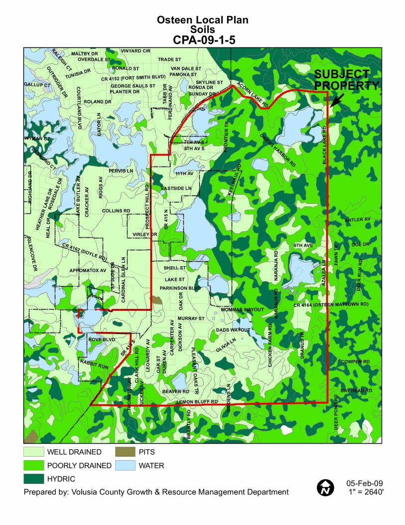
Osteen Local PlanSoils
05-Feb-09
SUBJECTPROPERTY
CPA-09-1-5
WELL DRAINEDPOORLY DRAINEDHYDRIC
PITSWATER
SR 41
5 N
SR 41
5 S
LEMON BLUFF RD
KEEL
HAUL
RD
COURTLAND BLVDMURRAY ST
TRADE ST
CR 4162 (DOYLE RD)
BLAC
K LA
KE R
DAZ
ALEA
LN
CR 4152 (FORT SMITH BLVD)
CR 4164 (OSTEEN MAYTOWN RD)
DICK
SON
AV
DURE
N AV
COLLINS RD
URAN
US TR
6TH AVE
8TH AV S7TH AV S
DOE DR
RIGG
S AV
FAW
N TR
MALTBY DR
DEER
RUN
RD
ROLAND DR
LEON
ARDY
AV
TABB
DR
11TH AV
HIGH
LAND
DR
ANTLER AV
DEER
POND
RD
CARP
ENTE
R AV
FRON
TIER
TR
RONDA DR
HEAT
HER
LANE
DR
OAK
ST
BRAN
TLY R
D
COWPEN RD
SUNDAY DR
ACORN LAKE RD
OWENS HARBOR RD
NARA
NJA R
D
BAY HEAD RD
VINYARD CIRRALEIGH CTKOVE BLVD
PAMONA ST
OAK
DRPERVIS LN
MOMMAS WAYOUT
ROSE
DALE
DR
OUTRIGGER DR
LAKE
BUT
LER
AV
NEAL
DR
TUCK
ER AV
RABBIT RUN
EASTSIDE LN
TUNISIA DR
BEAVER RD
WYMAN CT
CRAC
KER
AV
CHIC
KEN
FARM
RD
OVERDALE ST
GATO
R LN
THOR
NTON
AV
VAN DALE ST
PLANTER DR
ST JU
DE LN
PLEASANT OAKS TR
GALLUP CT
DADS WAYOUT
GLENCOVE DR
CLAR
K HI
LL R
D
RONALD ST
PARKINSON BLVDLAKE ST
APPOMATOX AV
SKYLINE ST
VIRLEY DRGI
DDEN
S LN
GEORGE SAULS ST
DESMOND CT
SHELL ST
CARD
INAL
GLE
N LN
OLIVIA LN
FERD
INAN
D AV
PROS
PECT
HILL
RD
NARA
NJA R
D
Prepared by: Volusia County Growth & Resource Management Department 1" = 2640'
Osteen Local PlanVegetation
16-Feb-09
SUBJECTPROPERTY
CPA-09-1-5
URBANAGRICULTURE
FLATWOODSHARDWOOD FOREST
XERIC SCRUBWETLANDS
DISTURBED LANDSWATER
SR 41
5 N
SR 415 S
LEMON BLUFF RD
KEEL
HAUL
RD
MURRAY STBL
ACK
LAKE
RD
AZAL
EA LN
CR 4162 (DOYLE RD)
CR 4164 (OSTEEN MAYTOWN RD)
COURTLAND BLVD
DICK
SON
AV
DURE
N AV
COLLINS RD
URAN
US TR
6TH AVE
8TH AV S7TH AV S
CR 4152 (FORT SMITH BLVD)
DOE DR
ANTLER AV
RIGG
S AV
FAW
N TR
BUCK
SKIN
LN
PHONETIA DR
DEER
RUN
RD
ROLAND DR
LEON
ARDY
AV
TABB
DR
CYPRESS ISLES RD
11TH AVCA
RPEN
TER
AV
CR 5758 (ENTERPRISE OSTEEN RD)
RONDA DR
FRON
TIER
TR
OAK S
T
SANDLOR DR
DEER
PON
D RD
COWPEN RD
SUNDAY DR
HEAT
HER
LANE
DR
NARA
NJA R
D
OWENS HARBOR RD
BAY HEAD RD
CLOUDCROFT DR
KOVE BLVD
PAMONA ST
OAK D
R
DOG LEG TR
PERVIS LN
BRADDOCK AV
MOMMAS WAYOUT
LAKE
BUT
LER A
V
TWIN
LAKE
AVOUTRIGGER DR
TUCK
ER AV
RABBIT RUN
REDDITT RD
NEAL
DR
EASTSIDE LN
BEAVER RD
CRAC
KER
AV
CHIC
KEN
FARM
RD
TUNISIA DR
GATOR LN
VAN DALE ST
THOR
NTON
AV
WHITE TAIL CIR
PLEASANT OAKS TR
VARD
ON AV
DADS WAYOUT
CLAR
K HI
LL R
D
HOLL
Y RD
LAKE STPARKINSON BLVD
RONALD ST
SANDPIPER LN
APPOMATOX AV
VIRLEY DR
GIDD
ENS
LN
GEORGE SAULS ST
SATU
RN D
R
SHELL ST
4TH
ST E
CARD
INAL
GLE
N LN
OLIVIA LN
WILDERNESS WAY
BOWEN LN
1ST S
T E
NARA
NJA R
D
Prepared by: Volusia County Growth & Resource Management Department 1" = 2640'
Cluster Residential (CR5)Mixed Use Village (MUV)Osteen Commercial Village (OCV)Rural Estate (RE)
Tech Center (TC)Transitional Residential (TR)Urban Residential (UR)Lakes
SR 41
5 N
SR 41
5 S
LEMON BLUFF RD
KEEL
HAUL
RD
MURRAY ST
BLACK LAKE RD
CR 4164 (OSTEEN MAYTOWN RD)
CR 4162 (DOYLE RD)
AZAL
EA LN
DICK
SON A
V
DURE
N AV
COLLINS RD
URAN
US TR
6TH AVE
COURTLAND BLVD
8TH AV S7TH AV S
DOE DR
CR 4152 (FORT SMITH BLVD)
ANTLER AV
RIGG
S AV
FAWN
TR
BUCK
SKIN
LN
DEER
RUN
RD
ROLAND DR
LEON
ARDY
AV
TABB DR
11TH AVCA
RPEN
TER A
V
RONDA DR
COWPEN RD
MONUMENT DR ACORN LAKE RD
OWENS HARBOR RD
NARA
NJA
RD
BAY HEAD RD
KOVE BLVD DOG LEG TR
OAK
DR
PERVIS LN
MOMMAS WAYOUT
LAKE
BUT
LER
AV
TUCK
ER AV
ROSE
DALE
DR
RABBIT RUN
NEAL
DR
EASTSIDE LN
BEAVER RD
CRAC
KER A
V
CHIC
KEN
FARM
RD
GATO
R LN
THOR
NTON
AV
PLANTER DR
PLEASANT OAKS TR
DADS WAYOUT
LAKE STAPPOMATOX AV
VIRLEY DRGI
DDEN
S LN
SHELL ST
PINEHURST ST
Prepared by: Volusia County Growth & Resource Management Department 1" = 2640'
Osteen Local PLanCurrent Future Land Use
05-Feb-09
CPA-09-1-5SUBJECT PROPERTY
DELTONACOMMERCIALENVIRONMENTAL SYSTEMS CORRIDORFORESTRY RESOURCEPUBLIC SEMIPUBLIC CONSERVATION
RECREATIONALRESIDENTIAL LOWURBAN LOW DENSITYWATER
VOLUSIA COUNTYAGRICULTURE RESOURCECOMMERCIALCONSERVATIONENVIRONMENTAL SYSTEMS CORRIDORFORESTRY RESOURCELOW IMPACT URBAN
PUBLIC/SEMI-PUBLICRECREATIONRURALURBAN LOW INTENSITYURBAN MEDIUM INTENSITYWATER
NATURAL RESOURCE MANAGEMENT AREA (NRMA)
Attachment B - Environmental Assessment
ENVIRONMENTAL ASSESSMENT
OSTEEN LOCAL PLAN COMPREHENSIVE PLAN AMENDMENT
February 2009
Prepared by:
Planning Staff City of Deltona
GIS Data and Mapping Assistance by
Staff of Volusia Growth and Resource Management Department
1
Introduction This assessment was undertaken in support of the Osteen Local Plan comprehensive Plan amendment. The purpose of the assessment is to insure the Local Plan provides the same or enhanced level of protection for existing natural resources. Physical Features The Osteen Local Plan is situated on two physiographic areas of the County – the Deland Ridge and the Talbot Terrace. Both the Deland Ridge and Talbot Terrace are Pleistocene formations. The Deland Ridge was formed during a time of stable sea levels by oceanic and aeolian activity similar in process to how modern day sand dunes are formed on the beach. The Deland Ridge in a natural context is associated with high and rolling topography, sandy, well drained soil types, and xeric vegetation. In addition, while limited, lakes and isolated wetlands can be found on the Deland Ridge as well as karst features such as sinkholes. The Talbot Terrace is a relict marine seabed that was exposed over time to rapid sea level recession. The Talbot Terrace can be described as an area of flat topography, a high water table, poorly drained soils, and abundant wetland and flood prone acreage. Natural vegetative communities established on the Talbot Terrace include pine/palmetto flatwoods, isolated and interconnected herbaceous and forested wetland systems and, to a minor extent, hardwood hammocks (See attached vegetation mapping). Natural Communities Natural resources within the Osteen Local Plan area are diverse and are shown on the vegetation map attachment. Much of this diversity is because the Osteen Local Plan, as previously described, is situated on two distinct physiographic areas of the County. Natural areas that are located to the west of SR 415 and north of Doyle Rd are mostly forested with a mixture of pines and oaks (See Table 1 below). The pine/oak landscape is characterized by a blend of longleaf pine and laurel and live oaks. Pine/Oak mix vegetative communities are common on the Deland Ridge where fire suppression allowing hardwood growth has occurred for many years. There are several wetland areas located east of SR 415 and north of Doyle Rd. The wetland areas are a mix of herbaceous and forested systems that are associated with the Lake Butler Chain of Lakes. Trees established in the Lake Butler wetlands located within the Osteen JPA area include cypress, pine and gums. Herbaceous growth includes maidencane, meadow beauty, and other gramineous growth. Table 1: Vegetation
Source: Volusia County GIS – County’s Vegetation data Other undeveloped acreage located west of SR 415 is situated south of Enterprise Osteen
2
Road. A portion of this area can be described as open water associated with Little Lake with adjacent littoral wetland areas. The wetlands are mostly comprised of pine, bay, and cypress. Undeveloped land located east of Little Lake can be described as a mixture of sapling pine trees, small oaks and other vegetation. The sapling growth is a result of a timber clear-cut operation that occurred a few years ago. It is anticipated, based on the soil characteristics and the previous vegetation type (sand pine scrub), that this clear-cut area will eventually grow into a sand pine forest. There is a herbaceous wetland located within the clear-cut area that includes maidencane, bluestem, and yellow eyed grass. Upland areas located east of SR 415 represent both xeric and mesic vegetative communities. The xeric communities are dominated by scrub vegetation and the mesic communities consist mostly of pine/palmetto flatwoods. The xeric scrub areas are interspersed throughout the eastern Osteen Local Plan, but are basically confined to small sandy knolls. These scrub areas are comprised with vegetation of varying heights and density. The scrub areas that are characterized by low canopy xeric oak scrub are most likely in this condition because of past mechanical manipulation. Other more densely vegetated scrub areas feature mature oaks and scattered sand pines. Pine flatwoods are the most common natural vegetative community located east of SR 415 and are typically associated with poorly drained soils and generally considered to be uplands. These pine flatwoods consist of a slash pine overstory with an understory of saw palmetto – a common natural landscape in central Florida. Medium sized trees such as small oaks and east Palatka holly are scattered throughout the pine flatwood areas. The area to the east of SR 415 transitions from the Deland Ridge physiographic area to the Talbot Terrace physiographic area. There are several lakes located along the eastern escarpment of the Deland Ridge. From the north to south the major lakes located east of SR 415 are as follows: Thompson, Acorn Fish, Black, Eulalia, Savannah, Dixon, Jackson’s Bay and Tyler. Some of these lakes, such as Dixon, are relatively deep and water levels tend to not fluctuate extensively. However, other Osteen Local Plan lakes, such as the Savannah and Jackson’s Bay, are shallow water lakes and water levels can experience dramatic changes. There is one unnamed lake located within the Local Plan area to the south of Maytown Road and is a man made feature resulting from past excavation activity. Wetland acreage located east of SR 415 is extensive and includes interconnected and isolated cypress domes, bay swamps, and wet prairies. Hydrology The Osteen Local Plan is located within the St Johns River basin, meaning that most drainage within the Osteen Local Plan area flows to the St. Johns River. Some small, individual sub-basins within the Osteen Local Plan are closed and do not have well established outfalls. The Butler Lake and related wetlands located west of SR 415 are connected to the Savannah system through a ditch that extends under SR 415. Most of the major wetland areas and lakes located east of SR 415 and north of Murray St (located south of Maytown Road) appear to generally drain north through both a system of well defined drainage ways and less defined sheet flow paths. A good portion of this flow eventually outfalls to the Deep Creek system which in turn empties into the St. Johns River well to the south of the Local Plan area. Drainage south of Murray St and east of SR 415 flows in a southerly direction where it is captured in the roadside swale/ditch system adjacent to Lemon Bluff Road and eventually outfalls directly to the St. Johns River. The Little Lake system located in the southwestern section of the Osteen JPA area appears to be a closed basin. During an extreme high water event, Little Lake may drain via sheet flow to the southwest, outfalling to a series of wetlands located out of the Osteen Local
3
Plan. 100-year Floodplain Floodplain acreage generally tracks major wetland systems throughout the Osteen Local Plan and accounts for about 1,800 acres of the Local Plan area (See floodplain map attachment). Soils Soils associated with the Osteen Local Plan consist of a range of well drained, poorly drained or hydric types (See Table 2 below). The soil types generally correspond to the physiographic areas of the Osteen. Well drained soils like Astatula Fine Sand are typically located on the Deland Ridge and the poorly drained soils (Myakka Fine Sand, etc.) are situated on the Talbot Terrace. Wetland acreage within the Osteen JPA area is associated with hydric soil types such as Samsula muck (See soils map attachment). Table 2: Soils CATEGORY ACRES Well Drained 1597Poorly Drained 1332Hydric 706Pits 5Water 349
Source: Volusia County GIS – County’s Soil data Wildlife and Listed Species The Osteen area does provide habitat for various species of animals. The more developed areas support a wide range of wildlife types that are tolerant of these areas such as mocking birds, squirrels, opossums, etc. The natural areas within of the Osteen Local Plan are populated by game animals such as deer, wild hog, and turkey. Large mammals such as bobcats and fox may also be present in the natural areas within the Osteen Local Plan. Avian wildlife within the natural portions of the Osteen Local Plan include a wide range of wading birds that feed in the wetland and lake areas as well as hawks, crows, songbirds, etc. The Osteen Local Plan also may provide habitat for listed species. The most probable listed species types that could be found within the Local Plan area are discussed as follows: Florida Black Bear: The Florida black bear is a wide ranging animal that depending on reproduction needs between 30,000 to 15,000 acres of land in which to roam and forage. Bears are listed as threatened because of habitat loss. Bears are typically shy creatures that avoid mankind. However, due to extensive urbanization and rural development throughout the State, bears have less natural lands in which to forage. Ultimately the result can be bear/human interaction and such interaction is typically not conducive to the wellbeing of the bear that becomes labeled as a nuisance. Ironically, bear-human interaction is a method used to track bear movement and activity. Bear road kill data and nuisance investigations can useful in determining if there is a significant bear presence in an area. However, bear sightings sometimes occur in areas where urban and suburban development have been established for many years and these events, while often garnering much media attention, are typically not useful in determining bear movements/range. A review of bear kill data from the year 2000 to present revealed that the nearest strike occurred in 2005 on SR 415 about 3 miles north of the
4
Local Plan area. The location of this strike north of the Local Plan area is associated with large tracts of undeveloped property. There have been no nuisance bears reported in the Osteen Local Plan area. However, since the year 2000 there have been 5 bear reports in this area of the County although the majority of these reports originated from points well east of the Osteen Local Plan area. Land located to the east of the Osteen Local Plan is generally undeveloped and has better access to the St Johns River corridor for bears. The bear kill and nuisance data indicate that the Osteen Local Plan, while being associated with some natural areas, is not prime bear habitat. The Osteen Local Plan is well outside normal bear travel corridors and development has been in existence long enough in time so that bears have learned to avoid the dogs, traffic, and related human activity associated with this development activity. Florida Scrub Jay: The habitat requirement of the scrub jay is extremely narrow and can be described as low canopy xeric oak scrub. Ideal low canopy xeric oak scrub habitat for jays can be described as oak scrub vegetation that is less than six feet tall interspersed with open patches of sand. This low canopy oak condition is typically a result of fire. However, land clearing, timber operations and other clearing operations of sand pine scrub or oak hammock areas that are established on well drained soils can lead to habitat conducive for scrub jays. Scrub jays in a pre-Columbian context were probably never very numerous. In modern times scrub areas are considered very suitable to the support of urban development. As scrub areas became developed, jay habitat and even the potential for jay habitat, has become scarce. Presently, because of extreme rarity, scrub jays are listed as threatened. Scrub jays have been observed within a scrub oak area of the Osteen Local Plan that was once located just west of Acorn Fish Lake. The scrub habitat occupied by the jays was a result of past land clearing activity. However, the observation was well over 10 years ago and the habitat has been further altered by human activity to a point where jays no longer occupy this area. There are some sandy deposits located south of the Acorn Fish Lake area where scrub vegetation is established. These areas are small and the habitat conditions, due to isolation and vegetative condition, do not appear to be conducive for jays. In addition, field reconnaissance performed by City staff to ascertain the condition of the scrub areas and check for jays revealed that the presence of jays within the Osteen Local Plan is highly unlikely. Gopher Tortoise: The gopher tortoise is a terrestrial turtle that is known for burrowing in the ground. Tortoises will occupy a wide range of habitat types including manmade areas like old fields, fence lines, pastures, etc. Tortoises tend to prefer well drained sites that are not overgrown with thick vegetation. Well drained soils are ideal for the creation of burrows which can extend six feet or more underground. However, tortoises can be found in poorly drained upland areas such as pine flatwoods. Areas with open vegetation are preferred by tortoises. Open vegetation facilitates tortoise foraging for grasses, herbs, berries, bugs, etc and allows for more efficient reproduction activity (egg incubation). Tortoises were once very common but as development progressed in the State, tortoises have become rare. Therefore, tortoises are listed as a threatened species. The Osteen Local Plan does have acreage, both natural and altered areas (old fields, cleared land) that are suitable to support tortoises. However, within the Osteen Local Plan ideal tortoise habitat is not abundant. Tortoises and burrows were observed in the field but the sightings were scattered thus indicating that there is a low tortoise per acre population within the Osteen Local Plan. Sandhill Crane: Sandhill cranes are large birds that forage in wetlands, open upland areas, pastures, fields, and sometimes suburban yards and roadsides. Sandhill cranes eat seeds, legumes, bugs, snakes and small rodents. Sandhill cranes are listed by the State of Florida as threatened. While Cranes are adaptable in terms of feeding, as evidenced by the fact that they can be observed foraging in developed areas, cranes are not as adaptable with regard to
5
nesting requirements. Cranes prefer to nest in shallow herbaceous wetland areas dominated by pickerel weed and maidencane, but it is common for these wetland types be filled, altered, or otherwise impacted. Nesting in wetland areas help deter predators, such as raccoons, feral dogs and cats, from reaching the crane nest and provide camouflage for nestlings. Sandhill cranes are a common sight within the Osteen Local Plan. There are abundant fields and clearings, mostly man made, that the cranes utilize for feeding. However, fields and cleared/grassed areas in the form of pastures, residential yards, and right-of-way areas are not rare within Osteen and are abundant outside of the Osteen Local Plan. Therefore, there is no shortage of areas for cranes to feed and forage and herbaceous wetland systems existing within the Osteen Local Plan may provide suitable habitat for crane nesting activity. Comprehensive Plan Analysis The City of Deltona and Volusia County are committed to protecting the natural resources within the Osteen Local area. The commitment for environmental protection within the Osteen Local Plan is evidenced by the fact that the most environmentally sensitive land has been earmarked with very low intensity land uses such as Rural Estate and Cluster Residential designations (eastern portions of the Osteen Local Plan). Designating the most environmentally sensitive acreage of the Osteen Local Plan area with low intensity, non-urban land use categories will ensure that urban development is directed away from such resources. In addition, urban development will be contained along the SR 415 corridor where public facilities can efficiently serve the planned urban development. The Osteen Local Plan is consistent with the following provisions of both the City and County Comprehensive Plans: City Objective D (FLU) Future Land Use designations will reflect the inherent capabilities and limitations of the existing natural features of the land. 9J-5.006(3)(b)(4) City policy 2F (FLU) Land area deemed to be environmentally sensitive within a proposed development shall be limited to the density outlined in the Conservation Element. Performance standards shall be developed by July 1, 2002 (date amended by Ordinance 11-2001, adopted at second reading by Deltona City Commission December 12, 2001) that will allow flexibility in considering environmentally sensitive land for density calculations. 9J-5.006(3)(c)(2,4,6) City policy 4C (Con) Land use activities adjacent to environmentally sensitive lands, including conservation areas designated in the Future Land Use and Recreation/Open Space Elements, shall be limited to non-intensive uses such as low density residential. Otherwise, proposed land use activities must ensure that such activities will not degrade the natural physical, biological, aesthetic, or recreational functions of such lands. 9J-5.013(2)(c)(5,7,8&9) County Objective 1.2.1 Future Land Use designations will reflect the inherent capabilities and limitations of the existing natural features of the land. County policy 1.2.2.8 Structures shall be discouraged within the 100-year flood plain; however, if located therein, they shall be constructed to minimize the amount of additional fill, thereby reducing the potential for flood damage to the structure, supporting facilities, and adjacent property, consistent with the Flood Hazard Management section of the Land Development Code.
6
While the appropriate allocation of future land use designations is an important planning tool to protect natural resources, the implementation of land development regulations is also needed to protect these resources. Protection of Wetlands is similarly protected in the City and unincorporated area through the wetlands minimum standard element of the County Charter. All local governments are required to adopt regulations that are consistent with the minimum standards to protect wetlands. Both the City and the County have wetland protection regulations and the City works with County staff to implement City wetland regulations. The City and County wetland regulations utilize the same general philosophy that wetland impacts should be avoided. If such impacts are not avoidable, then wetland impacts should be minimized, and if impacts occur, then appropriate mitigation needs are required offset any wetland losses. In addition, the wetland minimum standards require that wetlands be safeguarded with an upland buffer. The Osteen Local Plan does contain provisions intended to protect wetlands. In addition, the Osteen Local Plan will also be required to be consistent with the following Objectives and Policies from the City and County Comprehensive Plans: City Policy 2d (FLU) Development occurring along the boundaries of environmentally sensitive areas shall be designed to protect and minimize the impact of development, consistent with the criteria included in the Conservation Element. 9J-5.006(3)(c)(6) City Objective F (FLU) Consistent with section 163.3202(1) F.S. the City of Deltona shall periodically review its Land Development Regulations to determine if said regulations provide for innovative design and the conservation of open space and natural resources. 9J-5.006(3)(b)(10) City Policy 1F (FLU) An environmental buffer of no less than 25 feet shall be utilized to protect the functional abilities of lake shores, streams, and upland extent of wetlands. The extent of the buffer will be determined by the location of the stream or wetland shoreline as described in the Conservation Element. 9J-5.006(3)(c)(4,6) City Objective E (FLU) The City of Deltona shall protect natural, archaeological, and historic resources from the adverse impact of development. This will be accomplished through the implementation of the land development regulations and coordination with appropriate permitting agencies. 9J-5.006(3)(b)(4) City Policy 1E (Con) Wetlands shall be preserved wherever possible. In cases where adverse impacts to such wetlands are found by the City to be the necessary to the overriding public interest, appropriate mitigation shall be required by appropriate permitting agency prior to land use or development approvals. 9J-5.013(2)(c)(1,3,5,6,8 &9) City Policy 3E (Con) Natural Buffer Zones or setbacks shall be required landward of all protected wetlands.
a. Natural Buffer Zones for funding wetlands shall be determined on an individual basis with standards and formulas derived for the following criteria, at minimum: existing soil erodibility; cover and type of vegetation; slope; water table depths; water quality; wildlife; and the protective status of the receiving waters. Natural buffer zones shall consist of intact natural
7
communities comprised predominantly of appropriate native vegetative species in the overstory, shrub, and understory layers. Activities within the Natural Buffer Zone shall be limited to those which are shown to be consistent with the intended use of this zone while providing for reasonable access to water bodies. b. Proposed activities adjacent to isolated wetlands shall have setbacks and natural buffers measured from the upland/wetland interface, as determined by vegetative dominance as appropriate with Rule 62.302 F.A.C. Wetlands which are hydrologically connected to a surface water body, shall require a natural buffer zone consistent with the standards provided in Subsection (a). c. In cases where the alteration of the Natural Buffer Zone is determined to be unavoidable, appropriate mitigation shall be required. 9J-5.013(2)(c)(1,3,6,8&9)
County Objective 12.2.3 To eliminate any net loss of wetlands and prevent the functional values of such wetlands to be degraded as a result of land development decisions. County Policy 12.2.3.5 There are several open water lakes situated within the Osteen Local Plan area. The lakes are amenities that can also be considered a community resource. The protection of these surface water features is a component of the Osteen Local Plan. Protection measures include directing urban intensity and density away from these areas and the utilization of land development regulations to protect lakes from stormwater run-off, etc. The protection of surface water bodies as illustrated in the provisions of the Osteen Local Plan is consistent with the following existing Comprehensive Plan provisions: City Objective B (Con) Protect and enhance the natural hydrologic functions and wildlife habitat attributes of surface water resources, wetlands, and the floodplains associated with these waters. 9J-5.013(2)(b)(2) City Policy 1B (Con) Prior to 2004, natural shoreline buffers or setbacks shall be reviewed for surface water bodies, the extent of which will depend on, at minimum: existing soils; cover and type of vegetation; topography; wildlife habitat; ambient water quality; and the protective status of the water body. 9J-5.013(2)(c)(1,3,6,8&9) County Objective 12.1.2 To protect and enhance the natural hydrologic functions and wildlife habitat attributes of surface water resources, including estuarine and oceanic waters, as well as waters which flow into estuarine and oceanic water, and the floodplains associated with these waters. County Policy 12.1.2.1 Natural shoreline buffers or setbacks shall remain established for surface water bodies, the extent of which will depend on, at minimum: existing soils; cover and type of vegetation; topography; wildlife habitat; ambient water quality; and the protective status of the water body. City Policy 8E (FLU) Structures shall be discouraged within the 100-year flood plain; however, if located therein they shall be constructed to operate with no loss in existing 100 year floodplain storage, thereby reducing the potential for flood damage to the structure, supporting facilities, and adjacent
8
property, consistent with the Land Development Code. 9J-5.006(3)(c)(6) City Policy 6B (Con) Dwelling unit densities shall be limited within the flood plains of surface water bodies and in other flood prone areas as provided for in land development regulations, in that allowable densities do not create potential flood hazards, or degrade the natural functions of the flood plain. Dwelling unit density determinations in the floodplain shall consider both site specific and cumulative impacts. 9J-5.013(2)(c)(9) County Policy 1.2.2.8 Proposed structures located within the flood plain of surface water bodies and within flood prone areas, shall continue to be required to utilize building methods as provided in land development regulations, to the extent that fill material required for construction or other impervious surfaces will not reduce the ability of the floodplains to store and convey floodwaters, or degrade the natural physical and biological functions of protected habitat without approved mitigation. Impacts of fill in the floodplains and floodprone areas shall be considered both site specifically and cumulatively. County Policy 12.1.2.9 Dwelling unit densities shall continue to be limited within the flood plains of surface water bodies and in other flood prone areas as provided for in land development regulations, in that allowable densities do not create potential flood hazards, or degrade the natural functions of the flood plain. Dwelling unit density determinations in the floodplain shall consider both site specific and cumulative impacts. City Objective E (FLU) The City of Deltona shall protect natural, archaeological, and historic resources from the adverse impact of development. This will be accomplished through the implementation of the land development regulations and coordination with appropriate permitting agencies. 9J-5.006(3)(b)(4) City Policy 2E (FLU) The City of Deltona shall protect the City's natural resources through the provisions contained in the Conservation and Infrastructure Elements of this Comprehensive Plan. All development proposals shall include adequate information concerning listed species and their habitat which may be on or adjacent to the proposed development site, such information including proposed mitigation actions shall be reviewed and approved prior to the issuance of the site development permit. Proposed commercial, industrial and multifamily development proposals shall include an environmental site survey performed by a qualified environmental biologist. 9J-5.006(3)(c)(6) City Policy 3F (FLU) The City of Deltona shall encourage cluster developments to preserve environmentally sensitive and other open space areas. 9J-5.006(3)(c)(1,2,5,7) City Objective D( Conservation) To minimize, and eliminate where reasonably achievable, impacts to ecological communities which degrade their natural physical and biological function as a result of land development activities. 9J-5.013(2)(b)(3) City Policy 1d (Con) By 2004, the City shall inventory, monitor, and periodically update a mapping inventory of
9
ecological communities by type (as indicated by vegetative composition), including at minimum: Wetland Communities, Upland Communities, Freshwater marsh, Pine flatwood, Wet prairie, Mixed hardwood hammock, Bottomland hardwood swamp, Oak hammock, Cypress swamp, Cabbage palm hammock, Bay head swamp, Pine/xeric oak thicket, Mixed hardwood swamp, Scrub oak thicket, Sand pine forest, Grassland, and shrub. 9J-5.013(2)(c)(3) City Policy 3D (Con) Based on the City's ecological data inventory, the City shall consider potential site specific, offsite, and cumulative impacts to ecological communities for land development proposals. 9J-5.013(2)(c)(3) City Policy 4D (Con) The City shall require clustering of dwelling units and/or open space for land development projects which contain environmentally sensitive lands and critical habitats within its project boundaries, in order to preserve these resources. 9J-5.013(2)(c)(3) City Policy 6D (Con) The City shall coordinate with appropriate governmental entities to protect environmentally sensitive lands which extend into adjacent counties and municipalities. 9J-5.013(2)(c)(8) Policy 7D (added by Ordinance 10-2001 adopted at second reading by the Deltona City Commission December 12, 2001) At a minimum, Environmentally Sensitive Areas shall contain one or more of the following natural resources:
a) Rare, Threatened or endangered wildlife and/or vegetation, e.g., wildlife (scrub jay, osprey); vegetation (golden polypody, butterfly orchid, four-petal paw paw). A complete list is defined by the U.S. Fish and Wildlife Service, Florida Game and Fresh Water Fish Commission and the East Central Florida Regional Planning Council; b) Rare and unique upland habitat that support endangered or threatened species; c) Wetlands; d) Special geologic formations; e) Artifacts of archaeological or historic significance; f) Within public water supply system wellfield cone(s) of influence; g) Within floodways and areas subject to flooding.
County Policy 1.2.1.1 The location of development and significance of topography, vegetation, wildlife habitat, flood hazard, the 100 year flood plain, and soils for a particular site will be determined during the development review process. County Policy 1.2.3.8 Volusia County shall encourage cluster developments to preserve environmentally sensitive land and other open space areas, but not to increase density above the existing land use category. County Objective 12.2.1 To provide for the protection of areas determined to be environmentally sensitive, and direct growth away from such areas.
10
County Policy 12.2.2.1 The County shall continue to monitor, and periodically update a mapping inventory of ecological communities by type (as indicated by vegetative composition), including at minimum:
Wetland Communities Uplands Communities estuarine marsh pine flatwood Mangrove swamp mixed hardwood hammock Freshwater marsh oak hammock Wet prairie cabbage palm hammock Bottomland hardwood swamp pine/xeric oak forests Cypress swamp scrub oak thicket Bay head swamp sand pine forest Mixed hardwood swamp coastal scrub Grassland and shrub
County Policy 12.2.2.3 Based on the County's ecological data inventory, the County shall consider potential site specific, off-site, and cumulative impacts to ecological communities as indicated in Policy 12.2.2.1 for land development proposals. County Policy 12.2.2.5 The County shall require clustering of dwelling units and/or open space for land development projects which contain environmentally sensitive lands and critical habitats within its project boundaries, in order to preserve these resources. County Policy 12.2.2.7 The County shall coordinate with appropriate governmental entities to protect environmentally sensitive lands which extend into adjacent counties and municipalities. County Policy 12.2.4.2 Land development proposals shall continue to be required to protect ecologically viable habitats and prepare a suitable alternative management plan when state or federally listed vegetative and wildlife species occur within project boundaries. County Policy 12.2.4.3 The County, under the current protected species policy, shall continue to review projects which may impact critical habitats. The type and occurrence of critical habitats which shall be determined by the County and the appropriate federal (USFWS) and state (FGFWFC, FDEP, ECFRPC) agencies. These development reviews shall address at minimum:
a. proper siting of development structures and infrastructure, including clustering of dwelling units away from critical habitats; b. management plans which protect endangered wildlife which utilize critical habitats; c. mitigation plans for critical habitat which is unavoidably altered; d. restrictions of the use of critical habitats to those which are found to be compatible with the requirements of wildlife species which are threatened, endangered, or of special concern.
The Osteen Local Plan contains hydric soil which can imply a jurisdictional wetland condition. The wetlands associated with hydric soil areas will be protected by the planning methods and regulations referenced in the above policy cites of the respective City and County
11
Comprehensive Plans. The protection of hydric soils is enhanced by the following City and County policies: City Policy 6H (Con) Building construction in soils which are determined to be hydric in character, as defined by the NRCS and the Florida Department of Agriculture, shall be regulated to the extent that proposed construction activities will not adversely impact the natural physical and biological functions of protected resources without appropriate mitigation. 9J-5.013(2)(c)(6) County Policy 12.4.2.2 Building construction in soils which are determined to be hydric in character, as defined by the NRCS and the Florida Department of Agriculture, shall be regulated to the extent that proposed construction activities will not adversely impact the natural physical and biological functions of protected resources without appropriate mitigation.
Attachment C - Public Participation
PUBLIC PARTICIPATION
SUMMARY
Of
THE OSTEEN JOINT PLANNING
PROCESS
1
Public Participation: The elected officials of the City of Deltona and County conducted 17 public meetings over the course of nearly 1 ½ years between February 2006 and August 2007 for the Osteen JPA. These meetings included opportunity for input from the citizens attending these meetings along with a survey conducted to obtain input from residents located within the Osteen JPA boundaries and in the surrounding area. This planning process built on the previous planning initiatives that were related to the Osteen JPA and each involved its own level of public involvement. These earlier planning initiatives included the South Central Volusia Study Area, SR415 Land Use Analysis, and Osteen Area Planning Needs Assessment. Earlier Planning Initiatives The South Central Volusia Study Area was initiated at the direction of the County Council in 2001 as a starting point to assess the future direction of growth and development in the south central portion of Volusia County. The study area generally followed a wide swath of land along the SR 415/Tomoka Farms Road Corridor between the coastal and inland urban areas. The portion of the Corridor within the study area extended approximately 28 miles through the southern half of Volusia County, including the Osteen Area, from the Seminole County line north to US 92 in Daytona Beach. The study led to a public workshop in April 2002 conducted by the County Council which reviewed various options to address growth within the area and directed staff to begin to establish dialogue with the affected cities and property owners. In late 2002, the planning firm Glatting Jackson, working for FDOT, was requested to review land use trends along the SR 415 corridor as part of FDOT’s initial planning and engineering studies for expansion of SR 415. Public workshops and stakeholder interviews were conducted to obtain input on the initial plans for expansion of this roadway and land use issues related to this transportation corridor. The land use recommendations resulting from this effort were presented in public workshops and a final report entitled “SR 415 Land Use Analysis Study.” One of the recommendations presented by the consultant to the County Council in September 2003 was the preparation and adoption of a Local Plan for the Osteen Community. The initial local planning effort that focused on the Osteen Community was facilitated by the Florida Conflict Resolution Consortium (FCRC) through sponsorship by Volusia County, the City of Deltona, the Osteen Civic Association, and the Osteen Preservation Society. This followed an effort by County staff at a community meeting in November 2004 to ascertain interest in pursuing a planning process for this area. Because of the divergence of opinions expressed at this meeting concerning growth and possibility of initiating a planning process, staff recommended that further community meetings be conducted by a professional facilitator. The FCRC conducted two public workshops to assess what additional planning, if any, the community felt was needed to address the potential for growth within the Osteen area. The process did not attempt to make any recommendations for what Osteen’s future should be, only what planning was needed to determine and guide that future. A survey between workshops asked residents to evaluate the acceptability of the planning options. This process resulted in neutral to good consensus to: • Create a plan for the SR 415 Corridor and an Osteen Center; • Develop Osteen Rural-Residential Plan Provisions; and • Develop a Deltona-Volusia County interlocal agreement that may include coordinated or
joint planning, annexation, service and revenue provisions.
2
Survey Conducted for the Osteen JPA To obtain further citizen input, the elected officials brought in the Stetson Institute for Social Research (SISR) to design and conduct a survey of the community during the summer and fall of 2006. The survey was intended to gain insight into the community’s thinking on a number of themes to assist the elected officials with the development of a joint land use plan for the Osteen JPA. The survey themes included:
• Quality of life • Pace of economic growth • Specific JPA issues (planning, parks, commercial and industrial development, roads,
The survey was conducted within three zones (A, B and C), to obtain results from questions pertaining to the above themes from property owners both within and adjacent to the Osteen JPA. Zone A consisted of property owners within the JPA, Zone B consisted of property owners within a one mile area surrounding the JPA, and Zone C consisted of property owners within a 1 mile area surrounding Zone B. The response rate to this survey was considered good with no significant non-response bias based on a follow-up telephone survey of the non-responders. The response rates were as follows:
• Total: 863 of 4010 possible = 22% • Zone A: 182 of 682 = 27% • Zone B: 471 of 1986 = 24% • Zone C: 205 of 1342 = 15%
Summary of Stetson University Survey Findings for Osteen: 1. The issues that were the strongest agreement for residents of all three zones:
• Environmentally sensitive lands should be protected from development. • Residential density should be limited. • Recreational spaces and facilities should be developed. • State Road 415 should be widened from Fort Smith Boulevard south to the Volusia
County line. • Zoning laws should be enforced to preserve current land use.
2. The issues where there was the strongest disagreement for residents of all three zones
were that within the JPA:
• Industrial development should be encouraged. • New residential development should ensure affordable housing for low and middle-
income families. • Population growth should be encouraged.
3
3. Other issues where a majority of property owners in all three zones were in agreement were that in the JPA:
• A joint City-County plan for growth should be developed. • Size of new commercial development should be limited. • Doyle Road (County Road 4162) should be widened. • All strategies that increase land values should be encouraged.
4. Issues that produced mixed opinion with neither agreement nor disagreement prevailing
were those in the JPA:
• Commercial development should be encouraged. • Commercial development along SR 415 should be permitted. • Extension of SR 417 should be sought. • Property owners should be allowed to develop their land as they please (here the
disagreement was between JPA property owners and those in the surrounding zones). 5. Relatively large differences were found among JPA (Zone A) property owners depending on
the type of property they owned. Those with residential property reported opinions very similar to those described above. Those who owned non-residential property were much more likely to favor road widening, commercial development, and property owner development rights.
The land use plan developed by the elected officials is generally consistent with the results of the survey. The general consensus among the property owners was that a joint City-County plan should be developed to address growth. Issues that have been addressed include: • Insuring that existing environmental resources be protected while at the same time, putting
into place specific design standards to achieve higher quality development that should lead to higher property values:
• Residential density and population growth within the JPA will generally remain the same as currently allowed under the County’s Future Land Use Map with a relatively small 2.3% decrease in residential unit potential and 15.9% increase in the maximum potential for non-residential development;
• New residential and non-residential development will be controlled through specific design standards with specific density and intensity limitations established by this amendment;
• Heavier industrial uses will not be allowed by the Tech Center land use category which is focused on creating a high value employment center featuring light manufactoring, office, research facilities, and flex office-warehouse space uses; and
• The elected officials are working to facilitate the expansion of SR 415 by FDOT.
Attachment D - Letter from the Volusia County Solid Waste Division
Attachment E - Letter from the Volusia County School Board
Page 1 of 16 Ordinance 2009-14
1 2 3 4 5 6 7 8 9
10 11 12 13 14 15 16 17 18 19 20 21
22
23
24
25
26
27
28
29
30
31
32
ORDINANCE NO. 2009-14
AN ORDINANCE OF THE COUNTY COUNCIL OF VOLUSIA COUNTY, FLORIDA, AMENDING THE VOLUSIA COUNTY COMPREHENSIVE PLAN ORDINANCE NO. 90-10 AS PREVIOUSLY AMENDED, BY AMENDING CHAPTER 1: “FUTURE LAND USE ELEMENT,” BY ADDING THE “OSTEEN LOCAL PLAN” INCLUDING BACKGROUND, FUTURE LAND USE DESIGNATIONS, GOALS, OBJECTIVES AND POLICIES; AMENDING THE “FUTURE LAND USE MAP” BY ADDING THE “OSTEEN LOCAL PLAN FUTURE LAND USE MAP” TO THE FUTURE LAND USE MAP SERIES CHANGING 3990 ACRES FROM AGRICULTURAL RESOURCE, COMMERCIAL, ENVIRONMENTAL SYSTEMS CORRIDOR, FORESTRY RESOURCE, LOW IMPACT URBAN, NATURAL RESOURCE MANAGEMENT AREA, PUBLIC/SEMI-PUBLIC, RURAL, URBAN LOW INTENSITY, AND URBAN MEDIUM INTENSITY TO OSTEEN LOCAL PLAN OSTEEN COMMERCIAL VILLAGE, MIXED USE VILLAGE, TECH CENTER, URBAN RESIDENTIAL, TRANSITIONAL RESIDENTIAL, CLUSTER RESIDENTIAL, AND RURAL ESTATE; PROVIDING FOR SEVERABILITY; PROVIDING FOR AN EFFECTIVE DATE.
WHEREAS, Section 163.3161, et seq., Florida Statutes, creates the Local
Government Comprehensive Planning and Land Development Regulation Act,
hereinafter referred to as the “Act”;
WHEREAS, Section 163.3167, Florida Statutes, requires each county in the
State of Florida to prepare and adopt a Comprehensive Plan as scheduled by the
Florida Department of Community Affairs; and
WHEREAS, the Volusia County Council has adopted the Volusia County
Comprehensive Plan Ordinance No. 90-10, pursuant to the Act; and
WHEREAS, Section 163.3187, Florida Statutes, provides for amendments to the
adopted Comprehensive Plan by the local government not more than twice during each
calendar year; and
Osteen Local Plan Comprehensive Plan
Page 2 of 16 Ordinance 2009-14
1
2
3
4
5
6
7
8
9
10
11
12
13
14
15
16
17
18
19
20
21
WHEREAS, the County Council of Volusia County, Florida desires to take
advantage of this statute and amend the Volusia County Comprehensive Plan; and
WHEREAS, the County Council of Volusia County, Florida has provided for
broad dissemination of these proposed amendments to this Plan in compliance with
Florida Statutes Sections 163.3181 and 163.3184(15); and
WHEREAS, pursuant to Section 163.3174, Florida Statutes, Volusia County
Zoning Ordinance No. 80-8, as amended, has designated the Volusia County Planning
and Land Development Regulation Commission as the local planning agency for the
unincorporated area of Volusia County, Florida
NOW, THEREFORE, BE IT ORDAINED BY THE COUNTY COUNCIL OF
VOLUSIA COUNTY, FLORIDA, AS FOLLOWS:
The Volusia County Comprehensive Plan, Ordinance No. 90-10, as previously
amended, is further amended as follows:
SECTION I: All Chapters and Elements of said Plan, including maps, map
series, tables and figures, are hereby amended to make them internally consistent; to
make them consistent with regional, state, or federal programs; to make them
consistent with objections, recommendations, comments and conditions imposed by the
Department of Community Affairs and by the Volusia County Growth Management
Commission; and to change dates as appropriate for consistency.
SECTION II: Chapter 1, “Future Land Use Element,” is hereby amended by
adding the following text in underline format:
22 23 24 25
E. LOCAL PLANS: This section contains localized or detailed plans that address issues or areas that either require additional analysis due to changing circumstances from the original Comprehensive Plan or
were required as part of implementing the Comprehensive Plan. The following Local Plans are contained in this section:
1. Highridge Neighborhood 2. Halifax Activity Center 3. Southeast Activity Center 4. Southwest Activity Center 5. Hontoon Island 6. North Peninsula 7. Mosquito Lagoon: Water Management Study 8. Enterprise 9. Wilbur-by-the-Sea 10. Samsula 11. Tomoka Farms Village 12. Jacksonville Bombing Range Complex Military Zone
27 28
29
30
31
32
33
34
35
36
37
38
13. Osteen
and by adding a new Section E. 13.: “Osteen Local Plan”, to be inserted after existing
Section E. 12, including background, future land use designations, and goals, objectives
and policies. Said amendment is appended hereto as Exhibit A, and by reference
made a part hereof.
SECTION III: Section F.: “Future Land Use Map” is hereby amended by adding
the “Osteen Local Plan Future Land Use Map” as Figure 1-24 to the future land use
map series for approximately 3990 acres changing the land uses from Agricultural
Resource, Commercial, Environmental Systems Corridor, Forestry Resource, Low
Low Intensity, and Urban Medium Intensity to Osteen Local Plan Osteen Commercial
Osteen Local Plan Comprehensive Plan
Page 4 of 16 Ordinance 2009-14
1
2
3
4
5
6
7
8
9
10
11
12
13
14
15
16
17 18 19 20 21
22 23 24
25 26 27
Village, Mixed Use Village, Tech Center, Urban Residential, Transitional Residential,
Cluster Residential, and Rural Estate. Said Figure 1-24 is appended hereto as Exhibit
B, and by reference made a part hereof.
SECTION IV: SEVERABILITY. Should any section or provision of this
Ordinance, or application of any provision of this Ordinance, be declared to be
unconstitutional, invalid, or inconsistent with the Volusia County Comprehensive Plan,
such declaration shall not affect the validity of the remainder of this Ordinance.
SECTION V: EFFECTIVE DATE. A certified copy of this Ordinance shall be
filed in the Office of the Secretary of State by the Clerk of the County Council within ten
(10) days after enactment. This Ordinance shall take effect upon the later of the
following dates: a) issuance of a certificate of consistency or conditional certificate of
consistency by the Volusia Growth Management Commission, and issuance of a final
order by the State of Florida Department of Community Affairs determining this
Ordinance to be in compliance with Florida Statutes Section 163.3184(9), or b) issuance
of a final order by the State of Florida Administration Commission determining this
Ordinance to be in compliance with Florida Statutes Section 163.3184(10).
ADOPTED BY THE COUNTY COUNCIL OF VOLUSIA COUNTY, FLORIDA, IN OPEN MEETING DULY ASSEMBLED IN THE COUNTY COUNCIL CHAMBERS AT THE THOMAS C. KELLY ADMINISTRATION CENTER, 123 WEST INDIANA AVENUE, DELAND, FLORIDA, THIS 20TH DAY OF AUGUST A.D., 2009.
ATTEST: COUNTY COUNCIL COUNTY OF VOLUSIA, FLORIDA
_____________________________ ____________________________ James T. Dinneen, County Manager Frank T. Bruno Jr., County Chair
Osteen Local Plan Comprehensive Plan
Page 5 of 16 Ordinance 2009-14
1
2
3
EXHIBIT A
Chapter 1: FUTURE LAND USE ELEMENT
E. Local Plans
13. OSTEEN LOCAL PLAN 4
Background: 5
6 The Osteen Local Plan area is located in southwest Volusia County along the SR 415 7 corridor between Lemon Bluff Road and Acorn Lake Road and includes 3,990 acres. 8 The Osteen Local Plan is the result of extensive intergovernmental coordination 9 between the City of Deltona, County of Volusia, and community stakeholders. On
10 December 5, 2008 the City and the County entered into a Joint Planning Agreement 11 (JPA). The JPA requires the local plan to be adopted into the respective 12 13
Comprehensive Plan of each local government.
14 From a planning perspective, the recognition of the SR 415 corridor as being suitable 15 for urban uses dates back to the 1990 adoption of the County’s Future Land Use Map. 16 In addition, through the years, the County and the City have amended their Future Land 17 Use Maps resulting in increases of urban intensity along the SR 415 corridor. The intent 18 of the Osteen Local Plan is to recognize and enhance the urban opportunities for the 19 area while protecting the rural and environmental characteristics that make up a 20 significant portion of the Osteen area. Development will be aesthetically pleasing, 21 22
functional and adequately supported by infrastructure. Descriptions of Future Land Use Designations: 23
24 25 The Osteen Local Plan includes a Land Use Map featuring land use designations that 26 are unique to the Osteen area and the map is to be included in the County/City map 27 28
series. The Osteen Land Use designations are described as follows:
29 1) Osteen Commercial Village (OCV) – The purpose of the OCV category is to 30 facilitate a mixed use, neo-traditional, development pattern featuring various 31 commercial (office, retail, etc.) and residential uses. The development pattern 32 within the OCV is intended to be a relatively dense mixture of multi-story, low and 33 medium rise buildings that contain both residential and commercial uses. On 34 small tracts of land, less than one acre in size, development may occur as 35 standalone uses. However, standalone uses will still need to adhere to the mixed 36 use purpose and intent of the OCV and be integrated into the larger development 37 pattern by at minimum, establishing linkages with other development projects. 38 Development shall provide vertical diversification of uses, where applicable, 39 requiring retail/office on bottom floors and office/residential on the upper floors.
Osteen Local Plan Comprehensive Plan
1 While residential uses are required, commercial is intended to represent the 2 dominant land use. Development within the OCV should be designed and 3 oriented around a grid pattern of cross access easements, alleys and streets. 4 Development linkages and pedestrian access as well as the incorporation of
plazas and other common areas are intended to be an integral part of the OCV. 5
OCV Development Intensities/Densities 6
Dwelling Units – Max 12 dwelling units per acre/Min 8 dwelling units per 7
acre 8
Intensity – Max FAR 0.5/Min FAR 0.25 9
Development Mix – 80% non residential/20% residential 10
11 2) Mixed Use Village (MUV) - The MUV is intended to facilitate a variety of housing 12 choices along SR 415. Housing types in the MUV can include single-family 13 dwellings on individual lots, townhomes, or medium density, low rise multi-family 14 formats. Strip commercial uses along major roads, including SR 415 are not 15 allowed in the MUV. However, commercial uses such as a community shopping 16 center may be allowed within compact nodes associated with the intersections of 17 major roads. Where possible commercial and residential development should be 18 combined into single buildings or otherwise mixed. Access to SR 415 shall be 19 limited. Cross access easements, parallel facilities or other methods will be used 20 to limit driveway cuts onto SR 415. Small parks, tot lots and open space areas
are intended elements of the MUV. 21 22
MUV Development Intensities/Densities 23 24
Dwelling Units – Max 8 Dwelling units per acre/Min 4 dwelling units per 25 acre 26
27 Wetlands: 1 du/10 acres 28
29 Intensity – Max FAR 0.35 30
31 Development Mix – 70% residential /30% non residential 32
33 34 3) Tech Center (TC) – The purpose and intent is to create a high value employment 35 center featuring light industrial, office, research facilities, and flex office space
Page 6 of 16 Ordinance 2009-14
Osteen Local Plan Comprehensive Plan
1 uses. Appropriate development details, such as campus design themes, will be 2 crucial in implementing the high-value vision for this category. In addition, access 3 to SR 415 shall be limited with access being provided by cross access
easements and eventually a roadway parallel to SR 415. 4 5
TC Development Intensity 6 7
Intensity – Max FAR 0.35 8 9
10 4) Urban Residential (UR) – The UR category is primarily a residential designation 11 that allows single-family dwellings on individual lots. In some cases low rise 12 multi-family or town home type developments may be allowed as a transition if 13 located next to mixed or commercial urban land uses associated with the SR 415 14 corridor. Limited neighborhood convenience type commercial uses may be 15 allowed along collectors, arterials or thoroughfares. However, neighborhood 16 commercial uses shall be of size and scale to only serve the immediate
neighborhood and be compatible with the general residential nature of the UR. 17 18
UR Development Intensities/Densities 19 20
Dwelling Units – Max 8 dwelling units per acre/Min 4 dwelling units per 21 acre 22
23 Intensity – Max FAR 0.25 24
25 Development Mix – Max 5% non-residential 26
27 28 5) Transitional Residential (TR) – The TR designation is intended to provide a 29 transition between more intense urban uses planned for the SR 415 corridor and 30 the rural and environmental characteristics of the land located in east Osteen. 31 Single family homes on individual lots will be the principal use. However,
townhome and duplex dwelling formats may be allowed. 32 33
TR Development Densities 34 35
Dwelling Units – Max 4 du per acre 36 37
Wetlands: 1 du/10 acres 38 39
Page 7 of 16 Ordinance 2009-14
Osteen Local Plan Comprehensive Plan
6) Rural Estate (RE) – The RE designation generally allows a large lot, rural type 1 development pattern. Single family dwellings on acreage oriented lots with either 2
3 personal use or agribusiness is the preferred use. Stand alone agribusiness 4 uses on lots which front SR 415 are consistent within this designation when 5 accompanied by adequate screening, architectural elevations and easements for 6 gateway signage to support community recognition. For purposes of this 7 designation, agribusiness shall be defined as those activities associated with the 8 producing operations of a farm, manufacture and distribution of farm equipment 9 and supplies or the processing, storage and distribution of farm commodities. To
10 protect agricultural or natural resources the RE does allow dwelling units to be clustered. 11
12 RE Development Densities 13
14 Dwelling Units - Max 1 du per 5 acres. 15
16 Wetlands: 1 du/10acres 17
18 19 7) Cluster Residential (CR) – The intent of the CR designation is to allow low 20 density residential development while affording protection to environmental 21 resources. Cluster subdivisions are to be used to direct development away from 22 natural resources. In addition, to limit habitat fragmentation natural resource and 23 open space areas shall be designed and located to maintain and enhance
corridor connections. The preferred development type within the CR will be 24 25 single family dwellings on individual lots. Lot sizes may vary depending on 26 individual cluster subdivision designs that will result in smaller net lot sizes. If the 27 property lies within ECO, the property owner may alternatively develop under the 28 conservation subdivision policies, goals and objectives and corresponding 29 conservation criteria and density set forth in the Smart Growth Initiative, of the
Volusia County Comprehensive Plan. 30 31
CR Development Densities 32 33
Category #1 - 1 dwelling per 25 acres 34 35
Category #2 - 1 dwelling per 20 acres 36 37
Category #3 – 1 dwelling per 10 acres 38 39
Page 8 of 16 Ordinance 2009-14
Osteen Local Plan Comprehensive Plan
Category #4 – 1 dwelling per 5 acres 1 2
Category #5 – 1 dwelling per 1 acre 3 4
Wetlands: 1du/10 acres 5 6
GOALS, OBJECTIVES, AND POLICIES 7 8 9
10 GOAL:
11 OST 1 Achieve a sustainable, fully functioning, well designed and aesthetic 12 urban, mixed use development pattern associated with the SR 415 13 corridor while appropriately protecting the rural and environmental 14 15
characteristics of the Osteen Local Planning Area.
16 17
OBJECTIVE:
18 OST 1.1 Provide an adequate interdependent mixture of land uses associated with 19 20
the SR 415 corridor.
21 22
POLICIES:
23 OST 1.1.1 Development within the Osteen Local Plan Area shall be consistent with the 24 25
following:
26 Osteen Land Use designations as depicted on the Osteen Future Land 27 28
Use Map;
29 30
All other Elements of the County and City Comprehensive Plan;
31 32
Current land development and zoning codes irrespective of jurisdiction;
33 34
Environmental standards and other regulations that may be applicable;
35 Smart Growth policies of the County’s Future Land Use Element 36 regarding ECO Map, excluding the City’s water treatment plant 37 development proposal.
Page 9 of 16 Ordinance 2009-14
Osteen Local Plan Comprehensive Plan
1 OST 1.1.2 To ensure that the Osteen Local Plan is appropriately implemented all 2 development requests must be processed as a Planned Unit Development 3 4
(PUD) except as follows:
5 Individual single family dwellings on parcels situated within residential 6 land use categories, provided that the parcel was legally created prior 7 8
to the adoption of the Osteen Local Plan.
9 OST 1.1.3 Existing individual single family dwelling uses and agricultural uses within 10 11
the Osteen Local Plan area may continue.
12 OST 1.1.4 Workforce housing shall be encouraged in the Osteen Commercial 13 14
Village, Mixed Use Village and Urban Residential designations.
15 OST 1.1.5 Incompatible land uses such as commercial and urban density shall be 16 17
directed away from the Rural Estate area.
18 OST 1.1.6 New strip commercial featuring a one store deep, single use retail 19 development pattern oriented towards a road or highway shall not be 20 21
allowed within the Osteen Local Planning area.
22 OST 1.1.7 Cluster type subdivisions that may occur within the Cluster Residential 23 designation shall provide a minimum of 70% open space with at least 30% 24 25
of that total used as common open space.
26 OST 1.1.8 The adoption of the Osteen Local Plan shall not change or limit the current 27 or potential uses on land within the Osteen Plan that is classified with the 28 29
Volusia County I-1 (Light Industrial) zoning.
30 OST 1.1.9 Public and/or Private civic oriented uses and essential services such as 31 schools, wells, water treatment plants, or medical facilities shall be 32 allowed in any land use category within the Osteen Local Plan, and are 33 34
exempt from the design standards and height standards of the Local Plan.
35 OST 1.1.10 Both the City and the County shall maintain intensity and density 36 calculations for each development and shall reconcile these numbers 37 annually to ensure the overall development mix is achieved at build out. 38 The County Planning Department shall maintain the annual density and 39 intensity calculation report as agreed upon by the City and County.
Page 10 of 16 Ordinance 2009-14
Osteen Local Plan Comprehensive Plan
Page 11 of 16 Ordinance 2009-14
1 2 3
OBJECTIVE:
4 OST 1.2 Urban development within the Osteen Local Plan will be adequately 5 6
served by appropriate infrastructure.
7 8
POLICIES:
9 OST 1.2.1 To protect rural areas, infrastructure will be directed away from land within 10 the Osteen Planning Area not designated or suitable for urban type 11 12
development.
13 OST 1.2.2 The City and the County shall continue to coordinate with the Florida 14 Department of Transportation, ECFRPC and Volusia County MPO to 15 support the widening/improvement of SR 415 as approved by the Florida 16 17
Department of Transportation.
18 OST 1.2.3 The City does not intend to establish central utilities within the Rural 19 Estate or Cluster Subdivision areas for the purpose of serving those 20 areas, unless such utilities are needed to correct threats to public health, 21 safety and welfare or to serve clustered housing where utilities are 22 23
deemed appropriate based on lot size, soil conditions, or other factors.
24 OST 1.2.4 The location of infrastructure such as roads and utility lines should be 25 directed away from wetlands and other natural resource areas. If the 26 location of infrastructure does result in impacts to wetlands or critical 27 28
habitat then suitable mitigation shall be required.
29 30
OBJECTIVE:
31 OST 1.3 Development design techniques shall be used to foster a development 32 pattern that is aesthetically pleasing, functional and enhances the 33 34
economic base of the area.
35 36
POLICIES:
37 OST 1.3.1 The County and City shall adopt land development regulations that will 38 39
accomplish the following:
Osteen Local Plan Comprehensive Plan
1 2
Ensure safe and convenient pedestrian access;
3 Limit driveway cuts onto SR 415 and other major roads by requiring 4 5
cross access easements and shared parking;
6 Require that internal streets and alleys be designed along a grid 7 8
16 Establish standards for architectural themes and building material type, 17 mass, orientation, fenestration;
18 Ensure that land uses are mixed and well integrated both horizontally 19 20
and vertically primarily in the OCV land use designations;
21 22
Protect natural resources;
23 Establish standards for open space and cluster subdivisions where 24 25
applicable; and
26 Encourage and incentivize “green” building techniques, including LEED 27 28
certification.
29 OST 1.3.2 The City and County recognize that the future land use designations 30 provided in Exhibit “B” of the JPA of December 5, 2008 includes design 31 criteria. The City and County shall implement the provisions of Exhibit “B” 32 which are not expressly incorporated in the local plan through their 33 34
respective land development regulations.
35 OST 1.3.3 The City and the County shall continue to notify and work together, 36 through both formal and informal processes, to ensure that land use plan 37 amendments, zoning requests, and other land development activities that 38 may be proposed within each respective jurisdiction are consistent with 39 the Osteen Local Plan.
Page 12 of 16 Ordinance 2009-14
Osteen Local Plan Comprehensive Plan
Page 13 of 16 Ordinance 2009-14
1 2 3
OBJECTIVE:
4 OST 1.4 Protect natural resources by directing residential density, and other 5 6
incompatible land uses away from such areas.
7 8
POLICIES:
9 OST 1.4.1 Notwithstanding the density allotments of the land use designations stated 10 in this policy, the dwelling unit density standard for wetlands within the 11 Mixed Use Village, Transitional Residential, Rural Estate, and Category 3, 12 13
4 and 5 of the Cluster Residential is one unit per 10 acres.
14 OST 1.4.2 To the greatest extent possible, wetlands within the Osteen Local 15 Planning Area shall be preserved. In situations where wetland impacts 16 17
are found to be unavoidable appropriate mitigation shall be provided.
18 OST 1.4.3 All wetlands situated within the Osteen Local Planning Area shall be 19 afforded a wetland buffer. The wetland buffer widths shall be a minimum 20 of 25 feet, unless otherwise permitted and mitigated in accordance with 21 the natural resource protection of the land development code, except in 22 the CR designation which requires an average 100 feet wetland buffer. 23 The City’s proposed water treatment plant site located within the CR 24 category shall maintain a minimum 25 feet wetland buffer. In the event 25 that the St. Johns River Water Management District requires a larger 26 27
wetland buffer, the most restrictive wetland buffer width shall apply.
28 OST 1.4.4 Land development standards and best management practices shall be 29 employed to protect the water quality of lakes and wetlands. Such 30 standards include setbacks, retention of native vegetation, appropriate 31 32
management of stormwater, and the minimization of shoreline alterations.
33 OST 1.4.5 The functions of flood plains and other flood prone areas shall be 34 protected by directing development away from such areas. If activities do 35 occur within floodplain or flood prone areas such impacts shall be 36 minimized. In addition, if development does occur within floodplain/prone 37 areas then techniques such as compensating storage and the 38 elevation/design of improvements shall be required to ensure that 39 floodplain functions are protected.
Osteen Local Plan Comprehensive Plan
Page 14 of 16 Ordinance 2009-14
1 2 OST 1.4.6 Conservation subdivision techniques shall be required for residential 3 development projects planned within the Cluster Subdivision designation. 4 Open space areas shall include wildlife and listed species habitat, 5 wetlands and other environmental characteristics. In addition, natural 6 7
connections shall be maintained to minimize habitat fragmentation.
8 OST 1.4.7 Land development proposals shall be required to protect ecologically 9 viable natural habitats. Management plans shall be required to ensure that
10 habitat is protected or mitigated consistent with applicable local, State and 11 12
Federal Agencies.
13 14
OBJECTIVE:
15 16
OST 1.5 Provide for transportation solutions of the SR415 corridor.
17 OST 1.5.1 Beginning on August 20, 2009, no more than 5,440 dwelling units or 5.7 18 million square feet of non-residential development within said area shall 19 be approved by development order of the City or County; but, in no event, 20 shall more than 1,360 dwelling units or 1.4 million square feet of non-21 residential development be approved by development order of the City or 22 County prior to January 1, 2015. The limitations imposed by this policy 23 shall not include dwelling units and non-residential square footage existing 24 25
prior to August 20, 2009.
26 OST 1.5.2 The City and County shall propose an access management plan that will 27 include an alternative network and parallel facilities plan for the Osteen 28 Local Plan area to be approved by the Florida Department of 29 Transportation, District 5 within twelve (12) months of the NOI issued by 30 31
the Department of Community Affairs for this local plan.
32 OST 1.5.3 Access to SR 415 will be limited by requiring the use of frontage/rear 33 roads, cross access agreements, shared parking and other methods as 34 35
deemed appropriate.
36 OST 1.5.4 The proper functioning of the urban land use designations associated 37 within the Osteen Plan are contingent on the construction of a network of 38 roads and parallel facilities. Such facilities are intended to direct traffic 39 away from SR 415. These improvements shall be constructed by 40 developers or funded through various approaches including fair share
Osteen Local Plan Comprehensive Plan
1 agreements, impact fees, grants or through other sources that become 2
3
available.
Page 15 of 16 Ordinance 2009-14
Osteen Local Plan Comprehensive Plan
Page 16 of 16 Ordinance 2009-14
Osteen Local Plan Comprehensive Plan
1 EEXX HH II BB II TT BB 2
3 4 5
SECTION F: FUTURE LAND USE MAP Figure 1-24
Osteen Local Plan Future Land Use Map 6 7
8 9
Editor Note: The Osteen Local Plan Future Land Use Map will be placed in the “Appendix 1: Maps & Figures”, as Figure 1-24.