City of Tacoma Community and Economic Development Department 747 Market Street, Room 1036 ▌ Tacoma, Washington 98402-3793 ▌ (253) 591-5365 http://www.cityoftacoma.org/planning TO: Planning Commission FROM: Donna Stenger, Manager, Long-Range Planning SUBJECT: Critical Areas Preservation Ordinance Update DATE: February 23, 2011 Staff is proceeding with the Critical Areas Preservation Ordinance (CAPO) revision process and has continued to meet with the stakeholder Focus Group as indicated in the schedule approved by the Planning Commission. The CAPO revision process includes minor changes needed in the code to clean up and clarify existing code language, as well as limited topics for discussion that will further update, clarify and streamline the existing code. The Focus Group met on December 9, 2010 and February 10, 2011. During the December 9 th meeting, the Focus Group discussed wetland buffer determination alternatives and wetland buffer modification currently required in the critical areas code. Guidance from the Department of Ecology (DOE) was discussed, specifically the various buffer alternatives presented in DOE’s “Wetlands in Washington State, Volume 2: Guidance for Protecting and Managing Wetlands in Washington State”. Benchmarking examples, diagrams depicting different buffer requirements and a table of 2010 permits depicting the difference in buffer requirements when using the two alternatives in Tacoma’s critical areas code were also discussed. The meeting held on February 10 th focused on completing the wetland buffer discussions and wetland mitigation options: mitigation banking and fee-in-lieu programs. An additional table of 2006 permits depicting the difference in buffer requirements was provided. That year was selected to provide information on single-family homes or small private development projects and how the buffer alternatives applied to those types of projects. Little difference in the two buffer alternatives was found whether large commercial or industrial development as compared to small single-family home development. Guidance from DOE and the Army Corps of Engineers was discussed concerning mitigation banks or in lieu fee programs and how these are used in other jurisdictions were identified and compared. Also for additional information on these subjects the Commission may want to access the following documents: 1. Mitigation that Works, Sustaining our remaining wetlands for people, fish and wildlife - http://www.ecy.wa.gov/pubs/0601009.pdf 2. The Credit/Debit Method for Estimating Needs in Compensatory Wetland Mitigation - http://www.ecy.wa.gov/pubs/1006013.pdf At the meeting on March 2, 2011, staff from the Current Planning Division will provide an overview of both meetings, including a summary of the comments. Attached, for the Planning Agenda Item GB-1
Transcript
City of Tacoma Community and Economic Development Department
TO: Planning Commission FROM: Donna Stenger, Manager, Long-Range Planning SUBJECT: Critical Areas Preservation Ordinance Update DATE: February 23, 2011 Staff is proceeding with the Critical Areas Preservation Ordinance (CAPO) revision process and has continued to meet with the stakeholder Focus Group as indicated in the schedule approved by the Planning Commission. The CAPO revision process includes minor changes needed in the code to clean up and clarify existing code language, as well as limited topics for discussion that will further update, clarify and streamline the existing code. The Focus Group met on December 9, 2010 and February 10, 2011. During the December 9th meeting, the Focus Group discussed wetland buffer determination alternatives and wetland buffer modification currently required in the critical areas code. Guidance from the Department of Ecology (DOE) was discussed, specifically the various buffer alternatives presented in DOE’s “Wetlands in Washington State, Volume 2: Guidance for Protecting and Managing Wetlands in Washington State”. Benchmarking examples, diagrams depicting different buffer requirements and a table of 2010 permits depicting the difference in buffer requirements when using the two alternatives in Tacoma’s critical areas code were also discussed. The meeting held on February 10th focused on completing the wetland buffer discussions and wetland mitigation options: mitigation banking and fee-in-lieu programs. An additional table of 2006 permits depicting the difference in buffer requirements was provided. That year was selected to provide information on single-family homes or small private development projects and how the buffer alternatives applied to those types of projects. Little difference in the two buffer alternatives was found whether large commercial or industrial development as compared to small single-family home development. Guidance from DOE and the Army Corps of Engineers was discussed concerning mitigation banks or in lieu fee programs and how these are used in other jurisdictions were identified and compared. Also for additional information on these subjects the Commission may want to access the following documents:
1. Mitigation that Works, Sustaining our remaining wetlands for people, fish and wildlife - http://www.ecy.wa.gov/pubs/0601009.pdf
2. The Credit/Debit Method for Estimating Needs in Compensatory Wetland Mitigation - http://www.ecy.wa.gov/pubs/1006013.pdf
At the meeting on March 2, 2011, staff from the Current Planning Division will provide an overview of both meetings, including a summary of the comments. Attached, for the Planning
Critical Areas Preservation Ordinance Revision February 23, 2011 Page 2 of 2 Commission’s information and discussion are the handouts provided to the Focus Group at each meeting and a summary of the comments. Staff is seeking direction from the Planning Commission on whether there are any additional items to consider based on the current discussions. The next meeting with the Focus Group will be April 14, 2011. This is the last scheduled meeting to discuss remaining clean-up items and any draft code language that is available on the main discussion topics. If you have any questions, please contact Karla Kluge at 591-5773 or [email protected]. DS:kk c. Peter Huffman, Assistant Director Attachments (3)
CAPO Meeting #2 Wetland Buffers (12-9-2010) and Meeting #3 (2-10-2011)
Public Stakeholder Attendees
Tiffany Spear, Master Builders of Tacoma Catherine Rudolf, Tacoma-Pierce County Association of Realtors Jason Jordan, Port of Tacoma Lois Stark and Mary Anderson, Metropolitan Park District Scott Hansen, Puget Creek Restoration Society Carrie Berry, Alex Berg, WSDOT Tim Attebery, Association of General Contractors Dan Fear, Friends of First Creek Bliss Moore, Sierra Club Laura Wigren, Cascade Land Conservancy Summary of comments for Wetland Buffers
• The comments reflected that the Focus Group was generally supportive regarding the adoption of one wetland buffer determination method. Alternative 3 is not providing better or bigger buffers, and it is costly to administer for the applicant and the City. The City would like to use a more predictable approach that allows customers to plan out their development with better assurance that they are allowing for buffers.
• A hybrid of Alternative 1 and Alternative 3 is used by other jurisdictions and the group would like staff to explore a hybrid that works in Tacoma.
• Alternative 3 allows for smaller buffers for low intensity projects and Metroparks would like to preserve that option because accessibility for wheelchairs and strollers is important to the Parks stakeholders.
• MetroParks does not want to see private development elevate expense for tax payer funded projects.
• There is an inherent conflict in GMA requirements for the protection of critical areas and the intended growth within urban areas. Members of the Focus Group liked how Wetlands of Local Significance recognize what is important and allows Tacoma to protect its “jewels”.
• Members inquired why the City continues to use WOLS when DOE removed the guidance when preparing the new Western Washington Rating Manual. The response is because the updated manual is based on science and the WOLS rating recognizes and includes the social value of a wetland in addition to the biological function identified in the DOE rating system.
• Be consistent with the Shoreline Master Program and the critical area code. • There is a desire to identify tools other than buffers to mitigate development.
Page 1 of 26
• Additional options may be needed for 25-foot lots in the City. Large buffers do not work in those cases.
• There was a concern expressed regarding WDFW and their timely response and additional permitting.
• When reviewing the buffer table examples from 2010, it was noted that there were few single family home developments to compare and the list was primarily for development for public entities. The group agreed that they would like to see a sampling of permits with more private development in years 2006 or 2007.
• The Focus Group was concerned about ensuring a value is derived from the permit process. They would like to see a smaller percentage of dollars going into the permits and consulting costs. Eliminate process for the sake of process only.
Parking Lot items
• Discuss berms as potentially important tools for protecting wetlands. • What is the process for delineation and jurisdictional calls for wetlands?
Summary of Comments for Mitigation Banks and In Lieu Fee Programs
• The Focus Group agreed that having the ability to participate in Mitigation banks and In lieu fee programs would be beneficial to Tacoma.
• In-lieu-fee programs need to consider the entire cost of the mitigation including the equivalent or comparable cost of replacement land in addition to the cost of building the project.
• The Focus Group would like to see mitigation occur within Tacoma when the impact occurs in Tacoma first before outside mitigation is considered. They wanted to ensure that the community that is affected by the impact receives the benefits of the mitigation efforts. In addition, Tacoma should have input in the process and approval for mitigation.
• The Focus Group discussed best available science with regard to how these programs work. For example, is replacement mitigation based on square footage or functions? The response is both. The “currency” for comparing the functions lost to the functions gained is called an “acre-point”. The actual acreage needed to replace functions lost is part of the calculation.
• The Focus Group discussed the specific adoption processes, responsibility for long term maintenance, and terms used to describe mitigation banks and In lieu fee service areas as they relate to small basins and large watersheds.
• The Focus Group was concerned that there may be issues within our watershed that make these programs more difficult which would force mitigation or environmental improvements outside the City. Are the difficulties science based and are there solutions? The response included an explanation on watershed and basin processes and defining boundaries that are science based. Tacoma is primarily in WRIA 10 and WRIA 12 and mitigation banks or In lieu fee sites built within those areas may offer additional mitigation options for Tacoma.
Page 2 of 26
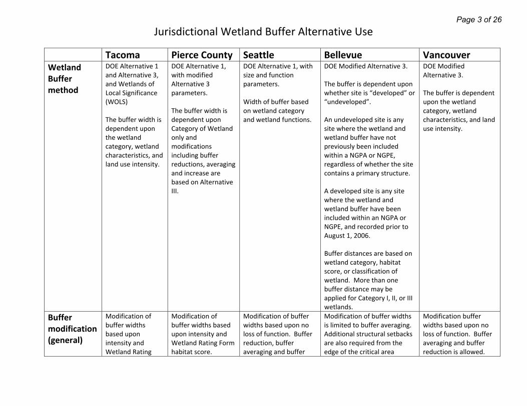
Jurisdictional Wetland Buffer Alternative Use
Tacoma Pierce County Seattle Bellevue VancouverWetland Buffer method
DOE Alternative 1 and Alternative 3, and Wetlands of Local Significance (WOLS) The buffer width is dependent upon the wetland category, wetland characteristics, and land use intensity.
DOE Alternative 1, with modified Alternative 3 parameters. The buffer width is dependent upon Category of Wetland only and modifications including buffer reductions, averaging and increase are based on Alternative III.
DOE Alternative 1, with size and function parameters. Width of buffer based on wetland category and wetland functions.
DOE Modified Alternative 3. The buffer is dependent upon whether site is “developed” or “undeveloped”. An undeveloped site is any site where the wetland and wetland buffer have not previously been included within a NGPA or NGPE, regardless of whether the site contains a primary structure. A developed site is any site where the wetland and wetland buffer have been included within an NGPA or NGPE, and recorded prior to August 1, 2006. Buffer distances are based on wetland category, habitat score, or classification of wetland. More than one buffer distance may be applied for Category I, II, or III wetlands.
DOE Modified Alternative 3. The buffer is dependent upon the wetland category, wetland characteristics, and land use intensity.
Buffer modification (general)
Modification of buffer widths based upon intensity and Wetland Rating
Modification of buffer widths based upon intensity and Wetland Rating Form habitat score.
Modification of buffer widths based upon no loss of function. Buffer reduction, buffer averaging and buffer
Modification of buffer widths is limited to buffer averaging. Additional structural setbacks are also required from the edge of the critical area
Modification buffer widths based upon no loss of function. Buffer averaging and buffer reduction is allowed.
Page 3 of 26
Jurisdictional Wetland Buffer Alternative Use
Form habitat score when in Habitat zone, or when function will be retained or improved when not in habitat zone.
Buffer reduction, buffer averaging, and buffer increase are allowed.
increase are allowed. buffer.
Buffer Averaging
Buffers may be averaged if the wetland functions will be improved or if it the only way to allow for use of the parcel. Averaging must occur in the more degraded portion of the wetland or lower Category area, the total area of the buffer remains constant, and ¾ of the standard width is retained.
Buffers may be averaged where the decrease is minimized by also limiting the development activity, no Priority Species is affected or a Habitat Assessment is submitted, there are no functional impacts, the total area of the buffer remains constant and ¾ of the standard width is retained, and a conservation easement or similar instrument is enacted. Additional tree protections are included.
Buffers may be averaged when there is no reduction in functions, the total buffer area remains constant and the buffer width minimum is met (table).
Buffer averaging is allowed only where other set back modification would not accommodate development, there is no change in ecological structure or function, the total area of the buffer remains constant, the buffer area is contiguous, there is no impact to slope stability or Priority Species habitats, and ¾ of the standard width is retained.
Buffers may be averaged where no Priority Species are affected, there are no functional impacts, the buffer function benefits from natural variation in the buffer, the total area of the buffer remains constant and ¾ of the standard width is retained with no less than 25 feet of buffer at a minimum.
Buffer Reduction
Buffer reduction is currently only allowed in wetlands within Habitat Zones.
Buffer reduction for high intensity impacts to wetland can be reduced to low intensity impacts
Buffers may be reduced through a variance when lot standards are met and the site does not qualify for buffer
Buffer reduction may be considered through a critical area report. Existing development within
Buffer reduction is based on reducing the intensity of land use impacts (Model CAPO table) and has a 100
Page 4 of 26
Jurisdictional Wetland Buffer Alternative Use
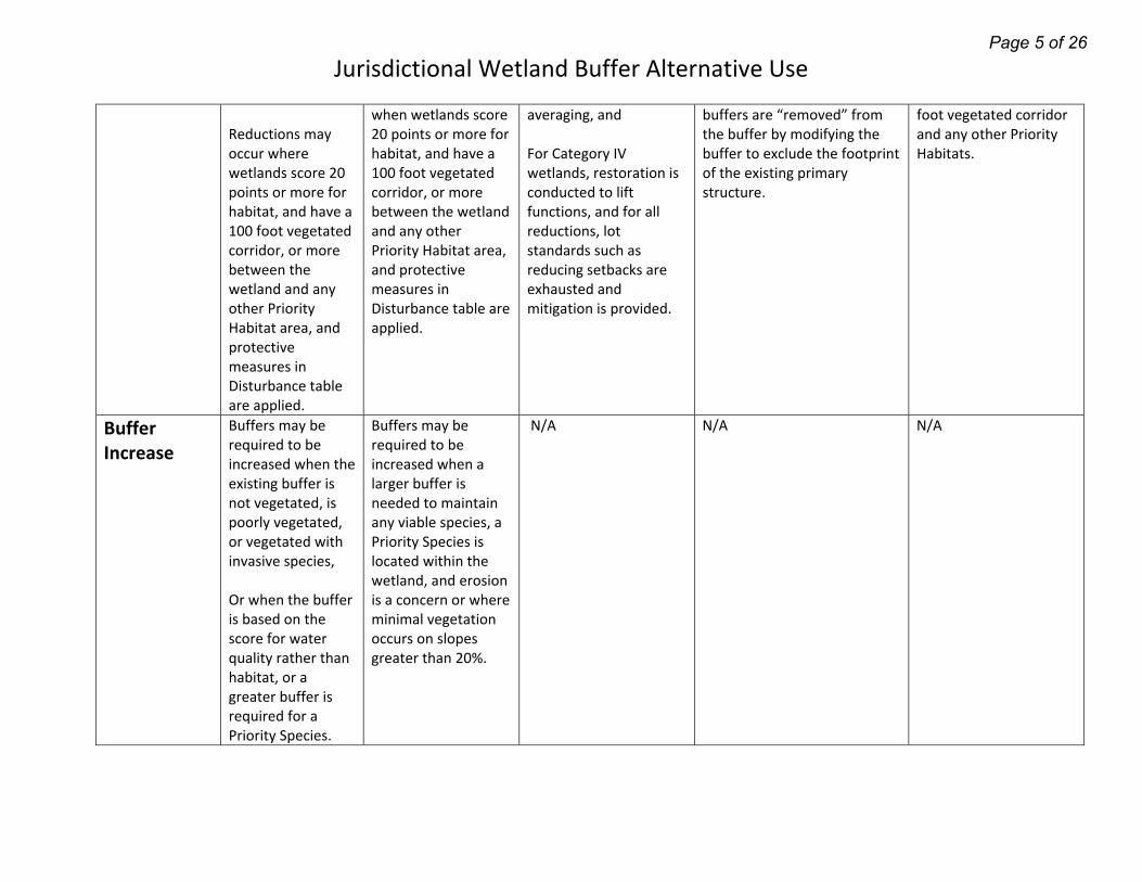
Reductions may occur where wetlands score 20 points or more for habitat, and have a 100 foot vegetated corridor, or more between the wetland and any other Priority Habitat area, and protective measures in Disturbance table are applied.
when wetlands score 20 points or more for habitat, and have a 100 foot vegetated corridor, or more between the wetland and any other Priority Habitat area, and protective measures in Disturbance table are applied.
averaging, and For Category IV wetlands, restoration is conducted to lift functions, and for all reductions, lot standards such as reducing setbacks are exhausted and mitigation is provided.
buffers are “removed” from the buffer by modifying the buffer to exclude the footprint of the existing primary structure.
foot vegetated corridor and any other Priority Habitats.
Buffer Increase
Buffers may be required to be increased when the existing buffer is not vegetated, is poorly vegetated, or vegetated with invasive species, Or when the buffer is based on the score for water quality rather than habitat, or a greater buffer is required for a Priority Species.
Buffers may be required to be increased when a larger buffer is needed to maintain any viable species, a Priority Species is located within the wetland, and erosion is a concern or where minimal vegetation occurs on slopes greater than 20%.
N/A N/A N/A
Page 5 of 26
2010 Wetland Buffer Table Comparison
Type of Permit WEX‐exemption WAS‐Assessment WDP‐Development Permit
Address Project Identification/ Description
Wetland Category (HZ means the wetland lies w/in a Habitat Zone)
Alternative 1 Wetland Buffer
Alternative 3 Wetland Buffer w/in Habitat Zone (HZ)
Wetlands of Local Significance (WOLS)
Change in project impacts to Critical Area
WDP 40000140374
1919 S Tyler Street
Snake Lake Enhancement
II HZ
N/A N/A 300 WOLS None. No buffer difference.
WEX 40000147730
2132 S Madison St.
SFD Demo II HZ
N/A N/A 300 WOLS None. No buffer difference.
WDP 40000151026
6810 S Cushman Ave.
Alaska Street expansion
II HZ
N/A N/A 300 WOLS None. No buffer difference.
WDP 40000140627
6420 (6402?) S Sheridan Ave.
Wapato park II HZ
N/A N/A 300 WOLS None. No buffer difference.
WAP 40000140641
415 N Stadium Way
Single family development w/ Ns2 stream with offsite wetland
IV HZ
50 50 N/A None. No buffer difference.
WEX 40000141325
6715 E Portland Ave.
Isolated wetland (268 Sq. ft.)
IV 50 50 N/A None. The wetland would be allowed to be filled under either scenario.
WEX 40000141368
3717 E Portland Ave.
Reconstruction of church within Ns1 stream buffer w/75 ft.
III HZ
75 80 N/A None. The project is outside both buffers.
Page 6 of 26
2010 Wetland Buffer Table Comparison
buffer (outside associated wetlands)
WEX 40000142702
1800 East 29th street
Type Np stream w/ 100 ft. buffer and associated wetland
II HZ
100 100 N/A None. No buffer difference.
WDP 40000143246
WSDOT I‐5 Widening
Outfall, Wetlands X and Y into Puyallup River (Type F stream)
X=IV Y=III HZ
X=50 Y=75
X=50 Y=80
N/A None. The buffers are interrupted by the river levee and the 5‐foot difference would not matter due to the interruption.
WEX 40000144337
4818 Nassau Ave. NE
Skate park at Norpoint Demo
III HZ
75 80 N/A None. The skate park would be allowed to be demolished regardless of the buffer distance.
WDP 40000145361
3429 N Alder St
Puget Creek pond dredging, restoration
I HZ
200 150‐300 depending upon the land use intensity of a development action
N/A None. The buffer would only change as projects progress from low intensity (restoration in a park) to high intensity (structures in the park).
WEX 40000145435
105 S 34th Street
Emergency Road Maintenance‐34th Street Gulch
II, III HZ
75‐100 60‐110 Moderate intensity
N/A None. The road needed to be repaired for life, safety issues and would be approved regardless of buffer distance.
WEX 1800 East “R” Street storm II 100 100 N/A None. No buffer
Page 7 of 26
2010 Wetland Buffer Table Comparison
40000147140 29th Street maintenance and repair
HZ difference.
WEX 40000147904
1202 Taylor Way
Hylebos Marsh Demo and redevelopment for oil/water separator
II HZ
100
100‐150 N/A None. The buffer is interrupted by pavement and ends at the edge of pavement, thus a larger buffer would not make any difference.
WAP 40000148309
2412 S 19th Street
Bates Tech College redevelopment
III HZ
75 80 N/A None. The applicant’s proposal for extended landscaping and a rain garden occur outside both buffers.
WEX 40000151141
115 S Stadium Way
Geotechnical exploration includes Np Streams with associated wetlands.
III 75 80 N/A None, the activity would still be considered exempt.
WDP 40000152085
9007 S 19th Street
FWHCA and Marine Buffer for Narrows Marina pump out station and replacement of boat elevators w/ single boat hoist. Also Crystal Creek is located nearby with its associated wetlands.
III 75 80 N/A None. The surrounding buffer area is highly developed as residential and Park area.
WEX 40000143247
WSDOT I‐5 Widening
Street widening with Ns1 stream and associated wetlands
II HZ
100 100 N/A None. No buffer difference.
Page 8 of 26
2010 Wetland Buffer Table Comparison
WDP 40000151379 Continued below….
8425 6th Ave.
Titlow park improvements
Numerous‐all within habitat zone*
Alternative 1
Alternative 3 WOLS
Titlow lagoon II HZ
100 100 N/A None.
Wetland A/AA II HZ
100 75 N/A Potentially less development.
Wetland Matrix B, C, E, F &Z
II HZ
100 75 N/A Potentially less development.
Wetland Matrix D, V, W
II HZ
100 75 N/A Potentially less development.
Wetlands Matrix G, H, I II HZ
100 40 N/A Potentially less development.
Wetland J II HZ
100 75 N/A Potentially less development.
Wetlands matrix K, L, M, & N
II HZ
100 75 N/A Potentially less development.
Wetland O II HZ
100 50 N/A Potentially less development.
Wetland P II HZ
100 50 N/A Potentially less development.
Wetland Q III HZ
75 40 N/A Potentially less development.
Wetland S II HZ
100 50 N/A Potentially less development.
Wetland T II HZ
100 75 N/A Potentially less development.
Wetland U III HZ
75 40 N/A Potentially less development.
Wetland Matrix X & Y III HZ
75 40 N/A Potentially less development.
Wetland 1 II HZ
100 75 N/A Potentially less development.
Page 9 of 26
2010 Wetland Buffer Table Comparison
Stream A ‐‐‐‐‐‐‐ N/A N/A N/A N/A Stream B ‐‐‐‐‐‐‐ N/A N/A N/A N/A Stream C ‐‐‐‐‐‐‐‐ N/A N/A N/A N/A Stream D ‐‐‐‐‐‐ N/A N/A N/A N/A Marine shoreline &
lagoon (FWHCA) ‐‐‐‐‐‐‐ N/A N/A N/A N/A
(Stream and FWHCA Exemptions and permitting)
WDP 40000152654
1940 Marine View Drive
FWHCA and Marine Buffer for Snitzer Steel outfall modification
_____ N/A N/A N/A
WEX 40000153644
1001 Port of Tacoma Road
FWHCA Maintenance Dredging of Blair
_____ N/A N/A N/A
WEX 40000154446
801 E Portland Ave.
FWHCA Marine Buffer _____ N/A N/A N/A
WEX 40000140513
709 E F St FWHCA Marine Buffer‐ demolition of 2 derelict buildings
_____ N/A N/A N/A
WEX 40000141569
2311 E 11th St.
FWHCA –Maintenance and Repair, Pier 7
_____ N/A N/A N/A
WAP 40000142802
4206 E Portland Ave.
Eastside Community Church‐Type Ns1 stream w/ 75 ft. buffer
_____ N/A N/A N/A
WEX 40000143407
1110 E Alexander Ave.
FWHCA marine buffer _____ N/A N/A N/A
WEX 40000143555
516 E D Street
FWHCA marine buffer _____ N/A N/A N/A
WEX 4002 N FWHCA ______ N/A N/A N/A
Page 10 of 26
2010 Wetland Buffer Table Comparison
40000145607 Waterview Street
Outfall Maintenance and Repair in water
WEX 40000146038
1171 Taylor Way
FWHCA and FWHCA Marine Buffer Site investigation (contaminated soils in waterway)
_____ N/A N/A N/A
WEX 40000146808
3401 Taylor Way
POT FWHCA marine buffer
_____ N/A N/A N/A
WEX 40000147535
5815 N Waterfront Drive
FWHCA Marine Buffer Maintenance and Repair for floats and piles
_____ N/A N/A N/A
WEX 40000148210
Murray Morgan Bridge
FWHCA and FWHCA Marine Buffer Maintenance and Repair
_____ N/A N/A N/A
WEX 40000148633
11 N Schuster Parkway
FWHCA TEMCO Maintenance and Repair
_____ N/A N/A N/A
WEX 40000149040
1123 Port of Tacoma RD.
FWHCA and Marine Buffer Maintenance and Repair, bulkhead /piles
_____ N/A N/A N/A
WEX 40000149338
1025 Dock St.
FWHCA Maintenance and repair‐covered moorage
_____ N/A N/A N/A
WEX 40000149480
4916 Marine View Drive
FWHCA and Marine Buffer Demo and shoreline maintenance and repair
_____ N/A N/A N/A
WEX 40000150206
5815 N Waterfront Dr.
FWHCA and Marine Buffer‐Pt. Defiance boathouse
_____ N/A N/A N/A
WDP 40000151023
820 E D Street
FWHCA and Marine Buffer ‐ Dock reconfiguration
_____ N/A N/A N/A
Page 11 of 26
2010 Wetland Buffer Table Comparison
WEX 40000151626
5815 N Waterfront Dr.
FWHCA and Marine Buffer Maintenance and repair
_____ N/A N/A N/A
WEX 40000151875
1101 Port of Tacoma Road
FWHCA in‐water soil sampling
_____ N/A N/A N/A
Page 12 of 26
Page 13 of 26
Page 14 of 26
Page 15 of 26
Page 16 of 26
Page 17 of 26
Page 18 of 26
Page 19 of 26
Page 20 of 26
2006 Wetland Buffer Table Comparison Permit Type WEX‐Exemption WAS‐Assessment WDP‐Development
Address Project Identification/ Description
Wetland Category
Wetland Buffer provided for this permit
Current Wetland Buffer using Alternative 1
Current Wetland Buffer using Alternative 3 w/in Habitat Zone (HZ)
Change in project impacts to Critical Area
WDP 40000041994
3902 S 19th Street
Wetland Development Permit for Violation correction involving Category III wetland and Type V Stream
III
50 75 80 High intensity Low habitat score
Project vested to CAPO in effect prior to 12‐31‐2005; if the permit was not vested additional buffer area may have been restored. Currently located w/in HZ.
WAP 40000064899
1702 Port of Tacoma RD
Wetland Assessment for POT property to determine jurisdiction.
A‐III B‐III
N/A – Jurisdictional determination
A&B‐75 A&B‐ 80 High Intensity Habitat score=10
None. The 2 wetlands were determined to be regulated. Currently located w/in HZ. Future development could result in a slightly smaller buffer area.
WEX 40000066513
817 E 27th Street (912 East 26th St)
Wetland exemption for interrupted buffers from Category IV Wetland and Type Ns Stream
IV
50 50 50 None. No buffer difference. The interrupted buffer exemption still applies. The entire buffer area within the subject parcel is improved and does not provide a functional connection to the wetland or stream. Currently located w/in HZ.
WAP 40000067653
2725 Henry Road
Wetland Assessment for 4‐lot short plat and new residences.
A/B‐IV C‐II
A/B‐50 C‐100
A/B‐50 C‐100
A/B‐50 High Intensity Habitat score=16 C‐100 High Intensity Habitat score=15 Water quality=16
None. Furthermore, the development included additional setbacks due to geotechnical considerations which exceed 100 feet on all associated wetlands. Currently located w/in HZ.
WEX 40000068067
4502 S. 16 Street (4702 S. 12th St.)
Wetland Exemption to remove and replace 4 power poles at Delong Park
A‐II B‐III C‐IV D‐IV
Wetlands of Local significance (WOLS) –300
N/A WOLS –300
N/A WOLS –300
None. No buffer difference because Wetland of Local Significance. The exemption allows work within the critical area or buffer with Best management practices and restoration of temporary impacts.
**Permit Cancelled** Wetland area determined to NOT meet wetland criteria. 4‐lot short plat.
No Wetlands on site
N/A N/A N/A None. The project would go forward without additional wetland review.
WAP 40000068572
2534 Vista View Drive
Wetland/Stream Assessment for Gavin O’Brien‐Single Family home. Type Np stream with 100‐foot buffer
N/A N/A N/A N/A None. This permit only involved stream buffers and therefore would not be altered by the proposed wetland buffer changes.
WEX 40000068716
1701 East Alexander Ave.
Wetland exemption under interrupted buffers for 4 new buildings on site.
II
100 100 100 High intensity Low habitat score
None. No buffer difference. The interrupted buffer exemption still applies. Currently located w/in HZ.
WDP 40000070277
1402 East 47th Street
Wetland Development Permit for drainage improvements within Type Ns1 stream buffer.
N/A N/A N/A N/A None. This permit only involved stream buffers and therefore would not be altered by the proposed wetland buffer changes.
WEX 40000071190
2315 North 27th Street
Wetland Exemption for nuisance abatement clean‐up.
IV
50 50 50 None. No buffer difference. Currently located w/in HZ.
WAP 400000071507
1807 East 38th Street
Wetland Assessment Permit for jurisdictional determination and 4‐lot short plat near a Type Np stream and wetland.
IV 50 50 50 High intensity Low habitat score
None. No buffer difference. Currently located w/in HZ.
WEX 40000072581
234 East 66th Street
Wetland exemption to fill a 400 sq ft isolated wetland.
IV 50 50 50 High intensity Low habitat score
None. The buffer requirement is the same. Furthermore, the isolated wetland exemption is applicable regardless of buffer width. Currently located w/in HZ.
WEX 40000072973
1919 South Tyler Street
Wetland exemption for trail at Snake Lake
II
WOLS –300 N/A WOLS –300
N/A WOLS –300
None. No buffer difference because Wetland of Local Significance. The exemption allows previous trails within a wetland or stream buffer provided the trail does not cross or alter regulated water.
Wetland exemption for the Titlow Beach Outfall Upgrade Storm fish and wildlife habitat improvement Project Crystal Springs‐Type F2 stream with 100‐ft buffer.
Lagoon only‐II
N/A –buffer width was not directly address in this exemption decision
None. Buffer requirements could be reduced using Alt. 1, but habitat improvement projects with HPA approval are exempt regardless of buffer width. Please note‐ future high intensity use or development could require a 150 foot buffer using Alt. 3. Currently located w/in HZ. See illustration # 2.
WDP 40000075000
Crystal Springs ROW
Wetland Development Permit for driveway construction violation near Np streams and wetlands.
A‐III B‐III C‐II
80 80 100
75 75 100
A/B‐80 C‐100 High Intensity Low Habitat score Low Water Quality
Although this is a violation resolution permit, Alt. 1 would result in a decreased buffer around Wetland A therefore requiring fewer square feet of buffer mitigation. Currently located w/in HZ.
WDP 40000076278
WSDOT/SR 16 HOV
Snake lake mitigation modification.
II
WOLS –300 N/A WOLS –300
N/A WOLS –300
None. No buffer difference because Wetland of Local Significance.
WEX 40000077413
45th Ave NE & Browns Point Blvd
Wetland Exemption for interrupted buffer water main replacement within improved Right‐of‐way (ROW).
III II
75 100
75 100
80 100 High Intensity Low Habitat score Low Water Quality
None. Currently located outside the HZ. The interrupted buffer exemption still applies. The entire project area is within the improved ROW.
WEX 40000078669
1746 Ruston Way
Wetland Exemption for Sewer Transmission maintenance
III 150 High Intensity Moderate Habitat
75 80 High Intensity Low Habitat
None. Despite buffer differences, the repair and maintenance exemption still applies provided BMP’s are used. Currently located w/in HZ.
WEX 40000078784
6500 South Sheridan Ave.
**Permit Cancelled** Wetland Exemption to pump fresh water into Wapato Lake.
N/A N/A N/A N/A None. Determined no Wetland Exemption needed to pump fresh water into Wapato Lake.
WEX 40000078786
4006 North Waterview
Wetland/Stream Exemption for Maintenance at Mason Creek (Type Np stream).
N/A N/A N/A N/A None. Stream only.
WEX 40000079178
2341 North 28th Street
Exemption for interrupted buffers near a wetland & Type Np Stream
II
100 100 100 High intensity Low habitat score
None. No buffer difference and the interrupted buffer exemption still apply. Currently located w/in HZ.
Wetland Assessment for 6 lot preliminary plat outside the buffer.
III
75 75 80 High intensity Low habitat score
None. No buffer difference because wetland currently located outside the HZ.
***WDP 40000080952
1809 East 31st Street
Wetland Development Permit for addition to single family home (ADU)
II
150 100 150 High intensity Moderate habitat score
Going from Alt. 3 to Alt. 1 would result in a smaller buffer, but the proposal could remain the same due to the hardship created by % buffers covering the lot. Currently located w/in HZ. See illustration #1.
***WDP 40000081117
1515 South Sunset Drive
Wetland Development Permit for violation and subsequent home encroaching upon Np & Ns stream & wetlands.
Wetland A‐IV Hanke‐III
50 75
50 75
50 80 High intensity Low habitat score
None. This parcel was already outside the habitat zone. Additionally, due to site constraints an increased buffer would not result in additional protected area.
WEX 40000082770
1416 East 67th Street
Wetland exemption to fill isolated wetland.
IV 50 50 50 High intensity Low habitat score
None. The buffer requirement is the same. Furthermore, the isolated exemption is applicable regardless of buffer width. Located outside HZ.
WEX 40000082853
2201 Portland Ave.
Wetland exemption for public utilities and interrupted buffer
III 80 75 80 High intensity Low habitat score
None. There is potentially a 5 foot buffer difference, but both exemptions still apply regardless of the buffer. See Illustration #3.
WAP 40000083004
2542 Vista View Drive
Wetland Assessment for a home addition near Np stream and wetlands.
IV
50 50 50 High intensity Low habitat score
None. The buffer requirement is the same. Currently located w/in HZ.
WDP 40000083806
4410 South 37th Street
Wetland Development Permit for access road, storm pipe, and fencing.
III 75 75 80 High intensity Low habitat score
None. This parcel was already outside the HZ.
WEX 40000085570
2715 North 32nd Street
Wetland exemption for interrupted buffer from a wetland and Ns2 stream
A ‐ IV 50 50 50 High intensity Low habitat score
None. No buffer difference. The interrupted buffer exemption still applies. Currently located w/in HZ.
***See attached illustrations
Total of 29 Wetland Files in 2006 15 Exemptions (6 residential & 1 commercial &3 Parks & 5 PW/Utilities projects) 6 Wetland Assessment Permits (5 residential & 1 commercial) 8 Wetland Development Permits (6 residential &2 PW /Utilities projects)