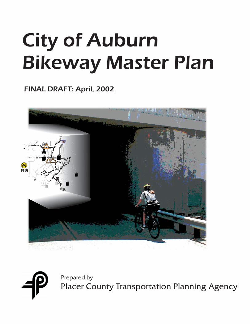
City of Auburn Bikeway Master Plan Prepared by Placer County Transportation Planning Agency FINAL DRAFT: April, 2002 FULWEILER AVE NEVADA 80 49 PALM AVE ELM AVE AUBURN RAVINE WAY HIGH ST LINCOLN PACIFIC AV E MIKKEL SE N D R
Transcript
City of AuburnBikeway Master Plan
Prepared by
Placer County Transportation Planning Agency
FINAL DRAFT: April, 2002
FULWEILER AVE
NEVADA 80
49
PALM AVE
ELMAVE
AU
BU
RN
RAVIN
E
WAY
HIGH
ST
LINCOLN
PACIFIC
AVE
MIK
KELSEN
DR
_____________________________________________________________________________ Placer County Transportation Planning Agency CITY OF AUBURN BIKEWAY MASTER PLAN Page i
TABLE OF CONTENTS_____________________________________ I. Introduction
A. Purpose ...........................................................................................1 B. Previous Planning Efforts ................................................................1 C. Relationship to Other Documents.................................................1-2 D. Past Expenditures ...........................................................................3 E. Plan Development and Public Participation.....................................3
II. Goals and Objectives A. Overall Goal .....................................................................................4 B. Objectives and Policies .................................................................4-5
III. Plan Elements
A. Definitions........................................................................................6 B. Setting .............................................................................................6 C. Land Use Patterns...........................................................................7 D. Bicycle Commuter Projections.........................................................7
Figure 1: City of Auburn Location .......................................................................... 8
E. Support Facilities .............................................................................9 F. Crossing Improvements.................................................................10 G. Bicycle Safety and Education ........................................................10
IV. Existing Bikeway Facilities.......................................................................... 11 Figure 2: Land Use & Existing Conditions........................................................... 12 V. Proposed Bikeway Improvements
Discussion ..........................................................................................13 Regional Connections.........................................................................13 A. Route Area Number 1....................................................................14 B. Route Area Number 2....................................................................15 C. Route Area Number 3....................................................................16 D. Route Area Number 4....................................................................17 E. Route Area Number 5....................................................................18 F. Route Area Number 6....................................................................19 G. Route Area Number 7....................................................................20 H. Route Area Number 8....................................................................21 I. Route Area Number 9....................................................................22
_____________________________________________________________________________ Placer County Transportation Planning Agency CITY OF AUBURN BIKEWAY MASTER PLAN Page ii
Figure 3: City of Auburn Ultimate Bikeway Network ....................................... 23 VI. Bikeway Funding
A. Federal Sources ........................................................................... 24-25 B. State Sources ............................................................................... 25-26 C. Local Sources............................................................................... 26-27
VII. Priority Bikeway Projects ............................................................................ 27
A. Cost Estimates....................................................................................28 B. Bikeway Design Standards .................................................................29 C. Compliance with California Bicycle Transportation Act .......................30
Appendix A: Auburn Bikeway Master Plan Project Summary Sheet Appendix B: California Bicycle Transportation Act Appendix C: Caltrans Deputy Directive DD-64 Appendix D: Bikeway Design Diagrams from Highway Design Manual Appendix E: Public Comment Summary
__________________________________________________________________________ Placer County Transportation Planning Agency CITY OF AUBURN BIKEWAY MASTER PLAN Page 1
I. INTRODUCTION________________________________ CITY OF AUBURN BIKEWAY MASTER PLAN PURPOSE The purpose of the City of Auburn Bikeway Plan is to develop a city wide bikeway network that coordinates with the regional bikeway plan and complies with the requirements of the California Bicycle Transportation Act (Appendix B). Bicycling is becoming an increasingly popular transportation mode for commuting, running errands, fitness, and recreation. PREVIOUS BIKEWAY PLANNING EFFORTS The circulation element of the City of Auburn General Plan includes suggestions for Pedestrian and Bicycle transportation based on the Auburn Park Conservancy non-auto circulation plan. Those suggestions were utilized in the development of this plan. RELATIONSHIP TO OTHER DOCUMENTS 1. Regional Transportation Plan (RTP) for Placer County The RTP for Placer County was recently updated and was adopted in December of 2001. The 2001 RTP contains a description of non-motorized facilities, accompanied by a needs assessment and short and long range action plans. Regional project priorities are identified in the appendix, and projects within the Auburn City limits have been included in this plan. Future updates within the RTP non-motorized section may include regional routes within the Auburn City limits.
2. County General Plan Placer County’s General Plan was last updated in 1994. It includes a
section on non-motorized transportation that incorporates an overall goal of providing a safe, comprehensive, and integrated system of facilities for non-motorized transportation. The policies call for development of a comprehensive and safe system of recreational and commuter bicycle routes and coordination of County bikeways with neighboring jurisdictions.
__________________________________________________________________________ Placer County Transportation Planning Agency CITY OF AUBURN BIKEWAY MASTER PLAN Page 2
3. Auburn General Plan
The Auburn General Plan provides guidelines for development in the City of Auburn from 1992-2012. The General Plan includes a map of the Auburn Park Conservancy's non-auto circulation recommendations. The General Plan recommends implementation of the Conservancy's routes for recreational and transportation opportunities for Auburn residents. The map was reviewed in conjunction with the development of this plan, and routes were included as appropriate. Updates for the City of Auburn Bikeway Master Plan should be performed in conjunction with updates of the City of Auburn General Plan Circulation element.
4. I-80 Corridor Bicycle Plan The goal of the I-80 corridor study is to make bicycling a real travel option
in the I-80 corridor by developing continuous and safe bicycle facilities. The City of Auburn Bikeway Master Plan has been developed consistent with this goal. The areas in the City of Auburn that are relevant to the I-80 corridor are consistent with the I-80 corridor bicycle plan.
5. Placer County Regional Bikeway Plan The Placer County Regional Bikeway plan provides for a regional system
of bikeways for transportation and recreation purposes. The plan divides the eastern and western portions of the County at Colfax and the Tahoe basin, emphasizing regional connections between and within cities in the two areas. The Regional Bikeway Plan provides suggestions for jurisdictions to follow within city limits, as regional bikeways are frequently multi-jurisdictional. Suggestions within the Regional Bikeway Plan were utilized in the development of this document. The Regional Bikeway Plan was accepted by the PCTPA Board in August of 2001 and will soon be adopted by the Placer County Board of Supervisors.
__________________________________________________________________________ Placer County Transportation Planning Agency CITY OF AUBURN BIKEWAY MASTER PLAN Page 3
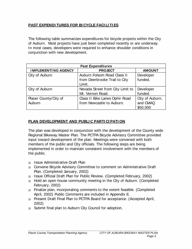
PAST EXPENDITURES FOR BICYCLE FACILITIES The following table summarizes expenditures for bicycle projects within the City of Auburn. Most projects have just been completed recently or are underway. In most cases, developers were required to enhance shoulder conditions in conjunction with new development.
Past Expenditures IMPLEMENTING AGENCY PROJECT AMOUNT
City of Auburn Auburn Folsom Road Class II from Deerbrooke Trail to City Limit.
Developer funded.
City of Auburn Nevada Street from City Limit to Mt. Vernon Road.
Developer funded.
Placer County/City of Auburn
Class II Bike Lanes Ophir Road from Newcastle to Auburn.
City of Auburn, and CMAQ $50,000
PLAN DEVELOPMENT AND PUBLIC PARTICIPATION The plan was developed in conjunction with the development of the County wide Regional Bikeway Master Plan. The PCTPA Bicycle Advisory Committee provided input toward development of the plan. Meetings were convened with both members of the public and City officials. The following steps are being implemented in order to maintain consistent involvement with the members of the public.
Issue Administrative Draft Plan Convene Bicycle Advisory Committee to comment on Administrative Draft
Plan. (Completed January, 2002) Issue Official Draft Plan for Public Review. (Completed February, 2002) Hold an open house community meeting in the City of Auburn. (Completed
February, 2002) Finalize plan, incorporating comments to the extent feasible. (Completed
April, 2002) Public Comments are included in Appendix E. Present Draft Final Plan to PCTPA Board for acceptance. (Accepted April,
2002) Submit final plan to Auburn City Council for adoption.
__________________________________________________________________________ Placer County Transportation Planning Agency CITY OF AUBURN BIKEWAY MASTER PLAN Page 4
II. GOALS & OBJECTIVES__________________________ OVERALL GOAL FOR THE CITY OF AUBURN BIKEWAY MASTER PLAN:
To promote safe, convenient, and enjoyable cycling by establishing a comprehensive network of bikeways that link the Activity Centers of Auburn and coordinate with the Placer County Regional Bikeway Plan.
OBJECTIVES AND POLICIES: 1. Create a safe and efficient network of bikeways that enhances bicycle use as
a viable alternative mode of transportation for commuter and recreational use and for the avid cyclists as well as the “weekend” rider. Policy: Implement the bikeway network by working closely with Placer County jurisdictions, bicycle advisory committees, and City Residents.
2. Encourage the City to consider the needs of cyclists when designing new or reconstructing existing facilities. Policy: Work with the County and other cities to incorporate state-of-the-art bicycle design guidelines into their overall policies for roadway and interchange design.
3. Coordinate with Placer County departments, cities, and other government entities to create continuity and consistency with existing and planned bikeway systems. Policy: Develop a prioritized list of bikeway projects for implementation on a City-wide basis.
4. Provide for bikeways that connect to work, school, shopping, transit transfer points, and recreational areas. Policy: Implement directional signage along bikeways to indicate connections to key destinations.
5. Create a bikeway system that takes advantage of the scenic qualities in Auburn for both resident and visitor to enjoy.
__________________________________________________________________________ Placer County Transportation Planning Agency CITY OF AUBURN BIKEWAY MASTER PLAN Page 5
Policy: Encourage Placer County jurisdictions to work with developers and bicycle groups to dedicate easements for bikeways.
6. Continue to fund and install bicycle racks on all Auburn Transit buses. Policy: Encourage all transit operators to include bicycle racks in specifications for new vehicles, and encourage operators without bicycle racks on existing buses to apply for funds to add them.
7. Integrate bicycle planning with other community planning, including land use and transportation planning. Policy: Include bikeways in City planning efforts.
8. Provide for an ongoing bikeway planning process. Policy: Update the prioritized project list as bikeway projects are implemented.
9. Maintain bikeways and related facilities in a condition favorable to safe and efficient use by cyclists. Policy: Develop an ongoing funding source for maintenance of bikeways.
10. Ensure safe conditions for cyclists through signage, traffic controls, engineering, and law enforcement efforts. Policy: Encourage addition of safety signage on shared roadways, and support safety education programs for bicyclists.
11. Promote awareness and use of the bikeway system through distribution of a map of all bicycle facilities. Policy: Working with the PCTPA, provide updated information for the regional bicycle map. Work with local groups to provide wide distribution to everyone including low income and minority communities.
12. Pursue all possible sources of funding for timely implementation of the bicycle master plan. Policy: Apply for all possible sources of funding including: Safe Routes to Schools, Congestion Mitigation and Air Quality, Transportation Development Act, State Bicycle Transportation Account.
__________________________________________________________________________ Placer County Transportation Planning Agency CITY OF AUBURN BIKEWAY MASTER PLAN Page 6
III. PLAN ELEMENTS___________________________________ DEFINITIONS The City of Auburn uses Caltrans’ design standards, as described in Chapter 1000 of the Caltrans Highway Design Manual, dated February, 2001.
Class I Bike Path provides a completely separated facility designed for the exclusive use of bicycles and pedestrians with minimal crossflows by motorists. Caltrans standards call for Class I bikeways to have 8 feet (2.4 meters) of pavements with 2 foot (0.6 meters) graded shoulders on either side, for a total right-of-way of 12 feet (3.6 meters). These bikeways must also be at least 5 feet (1.5 meters) from the edge of a paved roadway. Class II Bike Lane provides a restricted right-of-way designated for the exclusive or semi-exclusive use of bicycles with through travel by motor vehicles or pedestrians prohibited, but with vehicle parking and crossflows by pedestrians and motorists permitted. Caltrans standards generally require a 4 foot (1.2 meters) bike lane with a 6-inch (150 mm) white strip separating the roadway from the bike lane. Class III Bike Route provides a right-of-way designated by signs or permanent markings and shared with pedestrians and motorists. Roadways designated as Class III bike routes should have sufficient width to accommodate motorists, bicyclists, and pedestrians. Other than a street sign, there are not special markings required for a Class III bike route.
SETTING
The City of Auburn is located on the western slope of the Sierra Nevada range at elevations between 1,000 and 1,400 feet. Located along side the rugged American River Canyon, Historic Auburn is tucked away in the wooded foothills. The climate is mostly Mediterranean, with hot summers and mild winters just below the snow line. The foothill terrain of Auburn provides bicyclists with a challenging ride and splendid scenery. Scenic vistas and lookout points surround the City, which is characterized by lush trees, ravines and streams.
__________________________________________________________________________ Placer County Transportation Planning Agency CITY OF AUBURN BIKEWAY MASTER PLAN Page 7
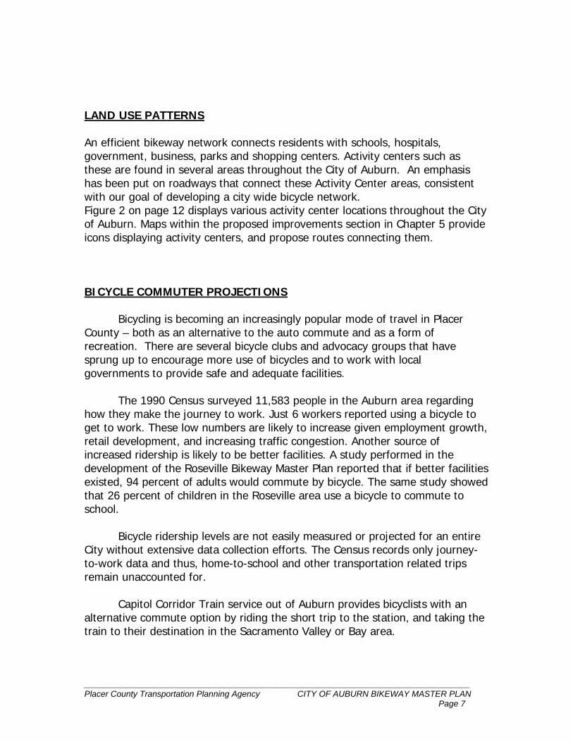
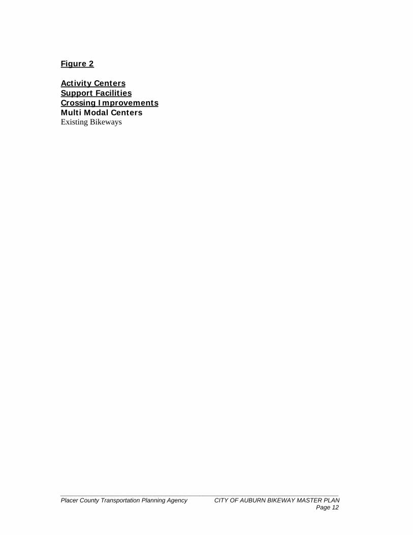
LAND USE PATTERNS An efficient bikeway network connects residents with schools, hospitals, government, business, parks and shopping centers. Activity centers such as these are found in several areas throughout the City of Auburn. An emphasis has been put on roadways that connect these Activity Center areas, consistent with our goal of developing a city wide bicycle network. Figure 2 on page 12 displays various activity center locations throughout the City of Auburn. Maps within the proposed improvements section in Chapter 5 provide icons displaying activity centers, and propose routes connecting them. BICYCLE COMMUTER PROJECTIONS
Bicycling is becoming an increasingly popular mode of travel in Placer
County – both as an alternative to the auto commute and as a form of recreation. There are several bicycle clubs and advocacy groups that have sprung up to encourage more use of bicycles and to work with local governments to provide safe and adequate facilities.
The 1990 Census surveyed 11,583 people in the Auburn area regarding
how they make the journey to work. Just 6 workers reported using a bicycle to get to work. These low numbers are likely to increase given employment growth, retail development, and increasing traffic congestion. Another source of increased ridership is likely to be better facilities. A study performed in the development of the Roseville Bikeway Master Plan reported that if better facilities existed, 94 percent of adults would commute by bicycle. The same study showed that 26 percent of children in the Roseville area use a bicycle to commute to school.
Bicycle ridership levels are not easily measured or projected for an entire
City without extensive data collection efforts. The Census records only journey-to-work data and thus, home-to-school and other transportation related trips remain unaccounted for.
Capitol Corridor Train service out of Auburn provides bicyclists with an alternative commute option by riding the short trip to the station, and taking the train to their destination in the Sacramento Valley or Bay area.
__________________________________________________________________________ Placer County Transportation Planning Agency CITY OF AUBURN BIKEWAY MASTER PLAN Page 8
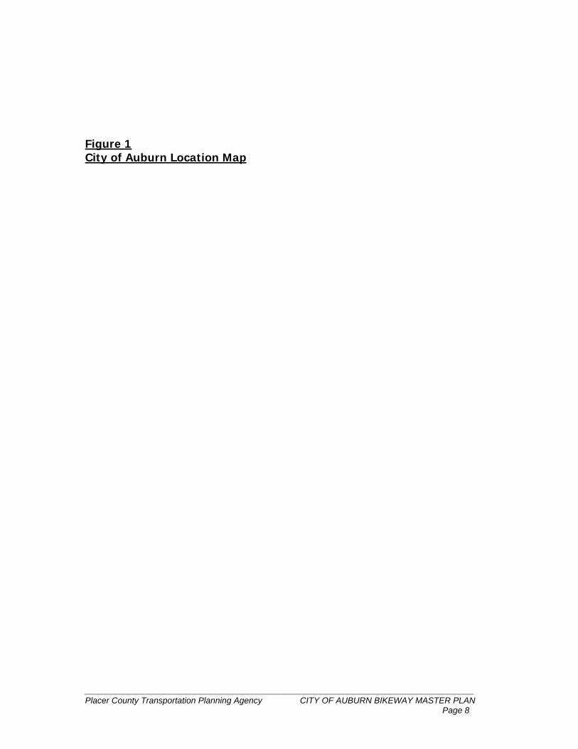
Figure 1 City of Auburn Location Map
__________________________________________________________________________ Placer County Transportation Planning Agency CITY OF AUBURN BIKEWAY MASTER PLAN Page 9
SUPPORT FACILITIES Support facilities such as bicycle parking, shower and locker facilities can encourage bicycling by reducing the threat of theft and making bicycling more convenient. Properly designed bike racks should be considered near major shopping and employment centers. These facilities should be considered for new developments that are likely to receive bicycle traffic including, but not limited to commercial centers, recreational facilities, and employment centers. Where possible, existing activity centers should be encouraged to add parking facilities if they are lacking. Bicycle parking facilities should be chosen based on (a) cost (b) ease of use (c) ability to prevent theft and (d) aesthetics. Access to shower and locker facilities may help encourage people to commute by bicycle. Many occupations require specific uniforms or formal attire such as suits and ties. Shower and locker facilities provide employees with the option to shower and dress at work. This is an important consideration for bicycle commuters, as the environmental conditions a bicycle commuter will encounter may vary. The following action is recommended for increasing the number of locations with bicycle parking, shower and locker facilities:
Encourage the installation of bicycle parking, shower and locker facilities where appropriate.
Actively pursue state and federal funding to install bicycle parking, shower, and locker facilities at existing activity and employment centers.
Major Activity Centers to be considered for support facility improvements in the City of Auburn: Employment:
Auburn Airport Industrial Area Commercial:
Elm Ave. Shopping Center Old Town Auburn Downtown Auburn Highway 49 Corridor within the Auburn City Limits
Multi - Modal Centers:
Auburn Train and multi-modal center.
__________________________________________________________________________ Placer County Transportation Planning Agency CITY OF AUBURN BIKEWAY MASTER PLAN Page 10
CROSSING IMPROVEMENTS The following improvements should be targeted for major intersections on the proposed bikeway system, and at locations where students cross busy streets to gain access to campus facilities. The following steps are recommended to build upon this effort:
Use signing, striping, flashing beacons, standard and international standard crosswalks, and pedestrian actuated signals at street crossings with high levels of pedestrian and bicycle demand.
Install bicycle detectors at signalized intersections along the bikeway system as intersections are upgraded. Detectors should be located within the striped bike lane or between the right turn lane and through lane.
BICYCLE SAFETY AND EDUCATION
1. City of Auburn Police Department/California Highway Patrol
The City of Auburn Police Department has primary responsibility for bicycle safety in the City of Auburn. Community service officers have developed a curriculum that teaches the basics of bicycle safety, helmet fit, use, and laws. Bike safety programs are performed on request, primarily at schools. Local bike shops often participate with a mechanic on duty to perform minor repairs and to notify bicycle owners of any necessary major repairs.
The California Highway Patrol also has officers dedicated to bicycle safety. They often work in a collaborative effort with the Placer County Sheriffs office and participate in bike education and safety programs.
2. California Law
California Law requires minors under the age of 18 to wear bicycle helmets. Officers may give citations or a type of “fix it ticket” in which violators will not be fined upon providing a helmet proof of purchase. On some occasions helmets are provided to those without them.
__________________________________________________________________________ Placer County Transportation Planning Agency CITY OF AUBURN BIKEWAY MASTER PLAN Page 11
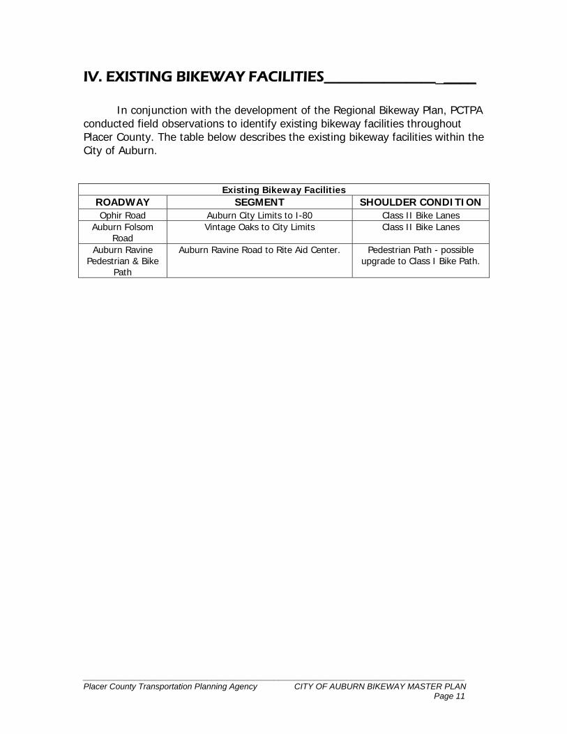
IV. EXISTING BIKEWAY FACILITIES____________________ In conjunction with the development of the Regional Bikeway Plan, PCTPA conducted field observations to identify existing bikeway facilities throughout Placer County. The table below describes the existing bikeway facilities within the City of Auburn.
Existing Bikeway Facilities
ROADWAY SEGMENT SHOULDER CONDITION Ophir Road Auburn City Limits to I-80 Class II Bike Lanes
Auburn Folsom Road
Vintage Oaks to City Limits Class II Bike Lanes
Auburn Ravine Pedestrian & Bike
Path
Auburn Ravine Road to Rite Aid Center. Pedestrian Path - possible upgrade to Class I Bike Path.
__________________________________________________________________________ Placer County Transportation Planning Agency CITY OF AUBURN BIKEWAY MASTER PLAN Page 12
Figure 2 Activity Centers Support Facilities Crossing Improvements Multi Modal Centers Existing Bikeways
__________________________________________________________________________ Placer County Transportation Planning Agency CITY OF AUBURN BIKEWAY MASTER PLAN Page 13
V. PROPOSED IMPROVEMENTS_____________________ Improvements must be made to accomplish the goal of developing a comprehensive bikeway network. This chapter offers suggestions for improvements based on the following criteria: • Coverage - The system should provide balanced access from locations
outside and within the City for both commuting and recreation purposes. • Safety - The network should provide the highest level of safety possible for
bicyclists and pedestrians while minimizing major safety concerns such as narrow roadways, bicycle/pedestrian conflicts, and auto/bike conflicts.
• Connectivity - The system should provide bikeway/pedestrian connections
to major activity centers, multi-modal centers, and to regional routes that leave/enter the City limits. Activity centers include residential areas, regional parks, shopping centers, employment centers, government centers, transit centers, and recreational areas.
The proposed improvements are presented in tables, which are separated by geographic area. Each table is presented with a map, which shows the upgrades and demonstrates connectivity developed between activity centers and among local and regional bikeways. REGIONAL CONNECTIONS An important element of the purpose of this plan is to consider the proposed bikeway system outside of the City Limits. Figure 3 on page 23 shows how the Auburn Bikeway network interfaces with regional bikeways.
80
BELL ROAD
BELL RD.
Placer County Transportation Planning Agency CITY OF AUBURN BIKEWAY MASTER PLANPage 14
ROUTE AREA NUMBER 1:Luther Road to Airport Industrial Area
SEGMENT LENGTH EXISTING CONDITION UPGRADE
C. Princeton Drive, Bill Francis Dr. To
Crystal Springs Rd.
Residential. Low traffic
volume/car speeds.
Residential. Low traffic
volume/car speeds.
Residential. Low traffic
volume/car speeds.
A
BC
BILL FRANCIS DR.
GRASS
VALLEY
HIG
HW
AY
NEW AIRPORT RD
LUTHER ROAD
D. Earhart Avenue, within Auburn City
Limits
Width sufficient for Class
II Bike Lanes.Class II Bike Lanes
D
B. Crystal Springs Road - entire length
A. Oak Ridge Way - entire length.Class III Bike Route.
Class III Bike Route
Make gate bike/ped friendly at
Oak Ridge & Crystal Springs
Class III Bike Route
LEGENDProposed Class IProposed Class IIProposed Class III
School
Shopping
Gate
N
S
EW
NOT TO SCALE
BusinessNEW AIRPORT RD.
OAK
RID
GE
WAY
CRYSTAL SPRIN
GS
.5
.25
.25
.5
ROUTE AREA NUMBER 2:Luther Road to Auburn Ravine Area
SEGMENT LENGTH EXISTING CONDITION UPGRADE
A. Dairy Road, entire length. Urban collector without an
existing shoulder. Bicycle use
is shared with auto traffic.
Urban collector without an
existing shoulder. Bicycle use
is shared with auto traffic.
NEVAD
A
80
STREET
MARGUERIT
E
MINE RD
DAIR
YRO
AD
AUBURN
RAV
INE
ROAD
LUTHER ROAD
A
B. Auburn Ravine Rd. from
Bowman Rd. to Marguerite Mine Rd.
B
Class II Bike Lanes.
Class III Bike Route.
Class III Bike Route.
N
S
EW
NOT TO SCALE
C. Marguerite Mine Road, entire length.
C
Shopping Center
School
LEGENDProposed Class I
Proposed Class II
Proposed Class III
Park
Placer County Transportation Planning Agency CITY OF AUBURN BIKEWAY MASTER PLAN
1
1
.75
Urban collector with shoulder
width varying from 0-3 Ft.
Page 15
ROUTE AREA NUMBER 3:North & South to Elm Avenue Shopping Center Area
SEGMENT LENGTH EXISTING CONDITION UPGRADE
A
B
C
A. Mikkelsen Drive, entire length. Wide residential collector.
Width sufficient for Class II
bike lanes.
B. Auburn Ravine Rd. from Mikkelsen
Dr. to Elm Ave.
Proposed Class II
Proposed Class II
C. Auburn Ravine Rd. from Palm Ave.
to Marguerite Mine Rd.Proposed Class III
N
S
EW
NOT TO SCALE
FULWEILER AVE
NEV
49
STREET
PALM AVE
MARGUERIT
E
MINE RD
ELM
AU
BU
RN
RAVIN
E
80
RO
AD
School
Shopping
Government
Rail Station
LEGENDProposed Class I
Proposed Class II
Proposed Class III
MIK
KEL
SEN
DR.
ADA
Placer County Transportation Planning Agency CITY OF AUBURN BIKEWAY MASTER PLAN
.5
.25
.5
Collector near activity center.
Shoulder width varies from
1-8 Ft.
Residential collector. Shoulder
width varies from 1-3 Ft.
AVE
Page 16
FULWEILER AVE
80
ELMAVE
WAY
HIGH
ST
ROUTE AREA NUMBER 4:Downtown Auburn/Elm Avenue Shopping Center
SEGMENT LENGTH EXISTING CONDITION UPGRADE
Class III Bike Route
Class III Bike Route
Class III Bike Route
Class III Bike Route
Class III Bike Route
N
S
EW
NOT TO SCALE
A
B
C
CD
D
A. Walsh St. From High Street to
McKenzie Court.
B. McKenzie Court: Install directional
signage from Walsh St. to provide
a connection to Elm/Auburn Ravine
Rd. crosswalk.
D. Lincoln Way from Maple St. (I-80 Exit)
to North High Street.
C. High St. from Lincoln Way. to
Auburn Folsom Rd.
School
Shopping
Government
Rail Station
LEGENDProposed Class I
Proposed Class II
Proposed Class III
NEVADA
ST
LIN
COLN
PIN
EST E
E. Pine St. from Walsh St. to Lincoln
Way.
Placer County Transportation Planning Agency CITY OF AUBURN BIKEWAY MASTER PLAN
.25
.25
1
1
.25
Residential collector. Low
traffic volume/car speeds.
Residential collector. Low
traffic volume/car speeds.
Through travel at End of
Court can provide bike/
ped crossing at signalized
intersection.
Bicycle use is shared with
motor vehicle traffic.
Bicycle use is shared with
motor vehicle traffic.
Page 17
WALSH ST
McK
enzie
Ct.
LINCOLN
WAYH
IGH
ST
ROUTE AREA NUMBER 5:Auburn Train Station/Elm Avenue Shopping Center Area
SEGMENT LENGTH EXISTING CONDITION UPGRADE
FULWEILER AVE
NEVADA
49
STREET
PALM AVE
MARGUERIT
E
MINE RD
ELM
AU
BU
RN
RAVIN
E
A
B
Proposed Class II
Proposed Class II
Proposed Class II
N
S
EW
NOT TO SCALE
C
School
Shopping
Government
Rail Station
A. Nevada St. from City Limit to
Fulweiler St.
B. Palm Ave. from Auburn Ravine Rd.
to Nevada St.
C. Mount Vernon Rd. from Nevada St.
to City Limit.
80
LEGENDProposed Class I
Proposed Class II
Proposed Class III
MIK
KEL
SEN
DR.
Placer County Transportation Planning Agency CITY OF AUBURN BIKEWAY MASTER PLAN
1
.5
.25
Arterial near activity centers.
Shoulder width varies from
1-3 Ft.
Collector near a school. Bike/
ped. crossing of HWY 49.
Shoulder/sidewalk improve-
ments necessary to achieve
Class II status.
Width sufficient for Class II
bike lanes.
Page 18
Business
FULWEILER AVE
80
ELMAVE
WAY
HIGH
ST
ROUTE AREA NUMBER 6:Downtown Auburn/Train Station
SEGMENT LENGTH EXISTING CONDITION UPGRADE
Class II Bike Lanes
Class III Bike Route
Class III Bike Route
Class III Bike Route
N
S
EW
NOT TO SCALE
A
B C
A. Nevada St. from Fulweiler to I-80.
B. Placer St. to and including Maple St.
I-80 overcrossing.
C. Maple Street, entire length.
D. Fulweiler Ave. from HWY 49 to
Nevada St.
School
Shopping
Government
Rail Station
LEGENDProposed Class I
Proposed Class II
Proposed Class III
NEVADA
ST
LIN
COLN
Placer County Transportation Planning Agency CITY OF AUBURN BIKEWAY MASTER PLAN
.75
.5
.25
.5
Bicycle use is shared with
vehicle traffic. Width
improvements necessary.
Bicycle use is shared with
vehicle traffic. Width
improvements necessary.
Bicycle use is shared with
vehicle traffic.
Bicycle use is shared with
vehicle traffic.
D
Page 19
Maple St.Plac
erSt
.
AUBURN
FO
LSO
M
E. Ophir Road, near I-80 under crossing. 200 Ft.Bicycle Lane ends due to
an existing short section of
sidewalk.
Class II Bike Lane
E
ROUTE AREA NUMBER 7:Lincoln Way from Hwy 49 to existing Class II at Flood Rd.
SEGMENT LENGTH EXISTING CONDITION UPGRADE
80
AUBURN
RAV IN
E
ELMAVE
LINCO
LN
WAY
HWY
49
AUBURN
RAVIN
E
FLOOD ROADLEGENDProposed Class IProposed Class IIProposed Class III
N
S
EW
NOT TO SCALE
School
Shopping A
B
C
A. Lincoln Way from Highway 49
to Flood Road.
Class II Bike Lanes
Placer County Transportation Planning Agency CITY OF AUBURN BIKEWAY MASTER PLAN
Arterial with a 1-2 ft.
shoulder. Bike/ped. traffic to
& from school on this road.
1
B. Foresthill Ave. from Lincoln Way to
Russel Rd. A portion of this segment
is outside the Auburn City Limit.
.75
C. Russell Rd. from Lincoln Way to
Foresthill Ave. This segment is
outside the Auburn City Limit.
.5
Local road with use by
bicyclists for recreational
purposes.
Local road with use by
bicyclists for recreational
purposes. Responsibility of
Unincorporated County.
Class III Bike Route
Class III Bike Route
FORESTHIL
L AVE
RUSSELL RD
Recreation Area
Page 20
ROUTE AREA NUMBER 8:Auburn Recreation District Area
SEGMENT LENGTH EXISTING CONDITION UPGRADE
HIGH
ST
AU
BU
RN
FO
LSO
MRO
AD
SACRAM
EN
TO
STREET
A
B
A. Pleasant Ave. from High St.
to Pacific Ave.
B. Pacific Street, entire length.
C. Sacramento Street, entire length.
D. Racetrack St. from Auburn
Folsom Rd. to Recreation Drive.
C
D
E
E. Recreation Drive, entire length.
N
S
EW
NOT TO SCALE
School
Government
LEGENDProposed Class I
Proposed Class II
Proposed Class III
Park
Class II Bike Lanes
Class II Bike Lanes
Class II Bike Lanes
Class III Bike Route
Class III Bike Route
Residential collector, 2-4
ft. shoulder.
Residential. Low traffic
volume/car speeds.
Residential. Low traffic
volume/car speeds.
LINCOLN WAY
.25
.75
1
.25
.25
Collector with a 2-4 ft.
shoulder. High recreation
use area.
Collector with 1-3 ft.
shoulders.
Placer County Transportation Planning Agency CITY OF AUBURN BIKEWAY MASTER PLANPage 21
PLEASA
NT
AVE
PACIF ICST
RACETRACK ST
RECREATIO
ND
R
FULWEILER AVE
80
Placer County Transportation Planning Agency CITY OF AUBURN BIKEWAY MASTER PLAN
Bikeways Existing or Plannedin Regional Bikeway Plan
������
�����
�
��� �
��
��
�����
��
�
������� ��
���
Class I
� ������� � �
��� �
���� �
URN
������� ���
II
II
II
II
II
III
III
III
III
Continues as existingor proposed Class II
Continues as existingor proposed Class III
Regional Connections
Rail Station
Bus Transfer Station
Park & Ride Lot
Shower and LockerFacilities
Bike Rack orBike Locker
Important Crossing
School
Government
Shopping
Business
Park/Recreation Area
Activity Centers
Multi Modal Centers
Support Facilities
PALM AVEAU
BU
RN
Figure 3
Placer County Transportation Planning Agency CITY OF AUBURN BIKEWAY MASTER PLANCity of Auburn Ultimate Bikeway Network
Page 23
__________________________________________________________________________ Placer County Transportation Planning Agency CITY OF AUBURN BIKEWAY MASTER PLAN Page 24
VI. BIKEWAY FUNDING____________________________________ A variety of funding sources are available for bikeways and related facilities. In order to be eligible for state funds, a Bikeway Master Plan must be in compliance with Streets and Highways Code Section 891.2 (see Appendix A). Federal and state sources applicable to the City of Auburn are provided below. FEDERAL SOURCES
Program, and Congestion Mitigation and Air Quality funds are authorized under the Federal Transportation Efficiency Act for the 21st Century (TEA-21). TEA-21 funds are distributed over a six-year period. As of January 2001, all TEA-21 funds available in the Sacramento region have been programmed. The next re-authorization of funds for transportation (including bicycle) projects will occur in 2003. Regional Surface Transportation Program (RSTP)
Placer County will receive approximately 7.5 million in RSTP funds over the six-year period of TEA-21. RSTP funds are distributed to incorporated cities and the unincorporated County per a population formula adopted by the PCTPA Board of Directors. Traditionally in Placer County this source of funds has been used for road overlay projects. As with other TEA-21 programs, projects must be included in an approved Federal Statewide Transportation Improvement Program (FSTIP), and a 20 percent local match is required for bicycle projects. Transportation Enhancement Activities Program (TEA)
TEA funds are to be used for transportation related capitol improvement projects that enhance quality of life in or around transportation facilities. Projects must be over and above required mitigation and normal transportation projects, and must be directly related to the surface transportation system. The projects must have a quality of life benefit, while providing the greatest benefit to the greatest number of people. Projects must be within one of twelve categories, seven of which can be or are related to bicycle and pedestrian projects: 1. Provision of facilities for pedestrians and bicycles 2. Provision of safety and educational activities for pedestrians and bicyclists 3. Acquisition of scenic easements and scenic/historic sites 4. Scenic or historic highway programs 5. Landscaping and other scenic beautification 6. Historic preservation
__________________________________________________________________________ Placer County Transportation Planning Agency CITY OF AUBURN BIKEWAY MASTER PLAN Page 25
7. Rehabilitation and operation of historic transportation facilities (including historic railroad facilities and canals)
Regional Transportation Planning Agencies (RTPA's), such as PCTPA, receive 75 percent of the $60 million in TEA dollars available California. Project sponsors should submit projects to RTPA's. In the previous funding cycle, Placer County received approximately $6 million in TEA funds. Congestion Mitigation/Air Quality Program (CMAQ)
CMAQ funds are directed to transportation projects and programs which contribute to the attainment or maintenance of National Ambient Air Quality Standards in non-attainment or air quality maintenance areas for ozone, carbon monoxide or particulate matter under provisions for the Federal Clean Air Act. In Placer County (mostly a non-attainment area), programming of CMAQ funds is emphasized on projects that can make a significant impact on the reduction of Nitrogen Oxide (NOx) emissions. Eligible projects must show a low cost per pound of NOx reduction. Historically, bicycle projects have been fairly high cost, due in part to low bicycle commute numbers. Placer County received approximately $8 million in CMAQ funds during the last cycle. Project sponsors should submit projects to PCTPA. Safe Routes to School Program (SR2S) During the fiscal years of 2000 and 2001, the SR2S program was designed as a demonstration project for the construction of bicycle and pedestrian safety and traffic calming projects. To be eligible, the projects had to correct an identified safety hazard or problem on a route that students use for trips to and from school. In October 2001, Governor Davis signed SB10 extending the SR2S bill for 3 more years. SB10 is expected to provide approximately $70,000,000 over the next three years for new sidewalks, bike lanes, trails and other projects which encourage students to walk or bike to school. Caltrans will be the agency conducting a call for projects. STATE SOURCES Bicycle Transportation Account (BTA) The BTA is intended to provide funds for bicycle transportation and to enhance bicycling for commuting purposes. Available funding has increased in recent years, and is now up to $7.2 million annually for five years beginning in Fiscal year 2001/02. After that time the fund will revert to $5 million annually. These funds are available for bicycle projects statewide on a competitive basis
__________________________________________________________________________ Placer County Transportation Planning Agency CITY OF AUBURN BIKEWAY MASTER PLAN Page 26
for any jurisdiction that has prepared and adopted a bicycle plan that complies with state guidelines. Applicants provide a local match of at least 10 percent of total project cost. No applicant may receive more than 25 percent of the total funds transferred into the BTA in a single fiscal year. The Bicycle Facilities Unit in the Caltrans Local Assistance Program selects projects for funding. Pedestrian Safety Program (PSP) Projects eligible for PSP funding include, but are not limited to, traffic calming measures, intersection safety improvements and any traffic safety or enforcement program authorized by law. Projects must correct an identified pedestrian safety hazard or problem. In 1999/2000 $8 million was provided in a one-time appropriation of funds. In order for the funding to continue, an appropriation must be included in the future State Budget Act or other legislation. Environmental Enhancement and Mitigation Program (EEM) The purpose of the EEM program is to mitigate the environmental impacts of new or modified public transportation facilities beyond the level required by the project's environmental document. Projects must demonstrate a direct or indirect relationship with the environmental impact of modifying an existing transportation facility or construction of a new facility after January 1, 1990. One category, which in some cases may be applicable to bicycle projects, is known as 'Roadside Recreational.' Roadside Recreational projects provide roadside recreational opportunities, including roadside rests, scenic overlooks, trails, trailheads, sno-parks and parks. Statewide, $10 million are available; applicable projects are to be submitted to the Resources Agency of California for evaluation. LOCAL SOURCES Local Transportation Fund (LTF) Under Article 3 of the Transportation Development Act (TDA), up to two percent of the LTF allocation to cities and counties can be used for bicycle and pedestrian projects. Revenues to the LTF program are derived from 1/4 cents of statewide sales tax. New Construction In some cases, portions of the proposed network will be completed as part of future development, construction or widening projects within the City of Auburn.
__________________________________________________________________________ Placer County Transportation Planning Agency CITY OF AUBURN BIKEWAY MASTER PLAN Page 27
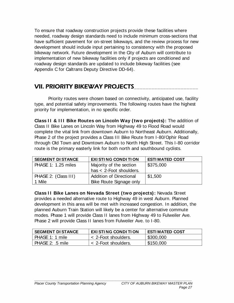
To ensure that roadway construction projects provide these facilities where needed, roadway design standards need to include minimum cross-sections that have sufficient pavement for on-street bikeways, and the review process for new development should include input pertaining to consistency with the proposed bikeway network. Future development in the City of Auburn will contribute to implementation of new bikeway facilities only if projects are conditioned and roadway design standards are updated to include bikeway facilities (see Appendix C for Caltrans Deputy Directive DD-64). VII. PRIORITY BIKEWAY PROJECTS______________________ Priority routes were chosen based on connectivity, anticipated use, facility type, and potential safety improvements. The following routes have the highest priority for implementation, in no specific order. Class II & III Bike Routes on Lincoln Way (two projects): The addition of Class II Bike Lanes on Lincoln Way from Highway 49 to Flood Road would complete the vital link from downtown Auburn to Northeast Auburn. Additionally, Phase 2 of the project provides a Class III Bike Route from I-80/Ophir Road through Old Town and Downtown Auburn to North High Street. This I-80 corridor route is the primary easterly link for both north and southbound cyclists. SEGMENT DISTANCE EXISTING CONDITION ESTIMATED COST PHASE 1: 1.25 miles Majority of the section
has < 2-Foot shoulders. $375,000
PHASE 2: (Class III) 1 Mile
Addition of Directional Bike Route Signage only
$1,500
Class II Bike Lanes on Nevada Street (two projects): Nevada Street provides a needed alternative route to Highway 49 in west Auburn. Planned development in this area will be met with increased congestion. In addition, the planned Auburn Train Station will likely be a center for alternative commute modes. Phase 1 will provide Class II lanes from Highway 49 to Fulweiler Ave. Phase 2 will provide Class II lanes from Fulweiler Ave. to I-80. SEGMENT DISTANCE EXISTING CONDITION ESTIMATED COST PHASE 1: 1 mile < 2-Foot shoulders. $300,000 PHASE 2: .5 mile < 2-Foot shoulders. $150,000
__________________________________________________________________________ Placer County Transportation Planning Agency CITY OF AUBURN BIKEWAY MASTER PLAN Page 28
Class II Bike Lanes on Palm Avenue: These lanes address a route in close proximity to a school, as well as providing for a safe crossing of Highway 49. SEGMENT DISTANCE EXISTING CONDITION ESTIMATED COST .5 mile Sidewalks exist without
additional room for Bike Lanes.
$150,000
Class II Bike Lanes on Auburn Folsom Road: This heavily used arterial provides a regional connection into and out of the City of Auburn. The existing conditions are conducive to Class II bike lanes, and a portion of the project is already complete. SEGMENT DISTANCE EXISTING CONDITION ESTIMATED COST 2.5 miles Signing and striping
required only $12,500
Class III Bike Route on Walsh Street: Establishing this roadway as a bike route will provide a bicycle connection under I-80 from downtown Auburn to Highway 49/Elm Ave. shopping center. This provides an alternative to the less bike-friendly Elm Ave. overcrossing. SEGMENT DISTANCE EXISTING CONDITION ESTIMATED COST .5 mile Addition of Directional
Bike Route Signage only. $750
Class III Bike Route on McKenzie Court: This route compliments the above-mentioned Walsh Street connection, by encouraging bicyclists to utilize the existing signal and crosswalk at Auburn Ravine Road/Elm Ave. SEGMENT DISTANCE EXISTING CONDITION ESTIMATED COST .25 mile Addition of Directional
Bike Route Signage only. $375
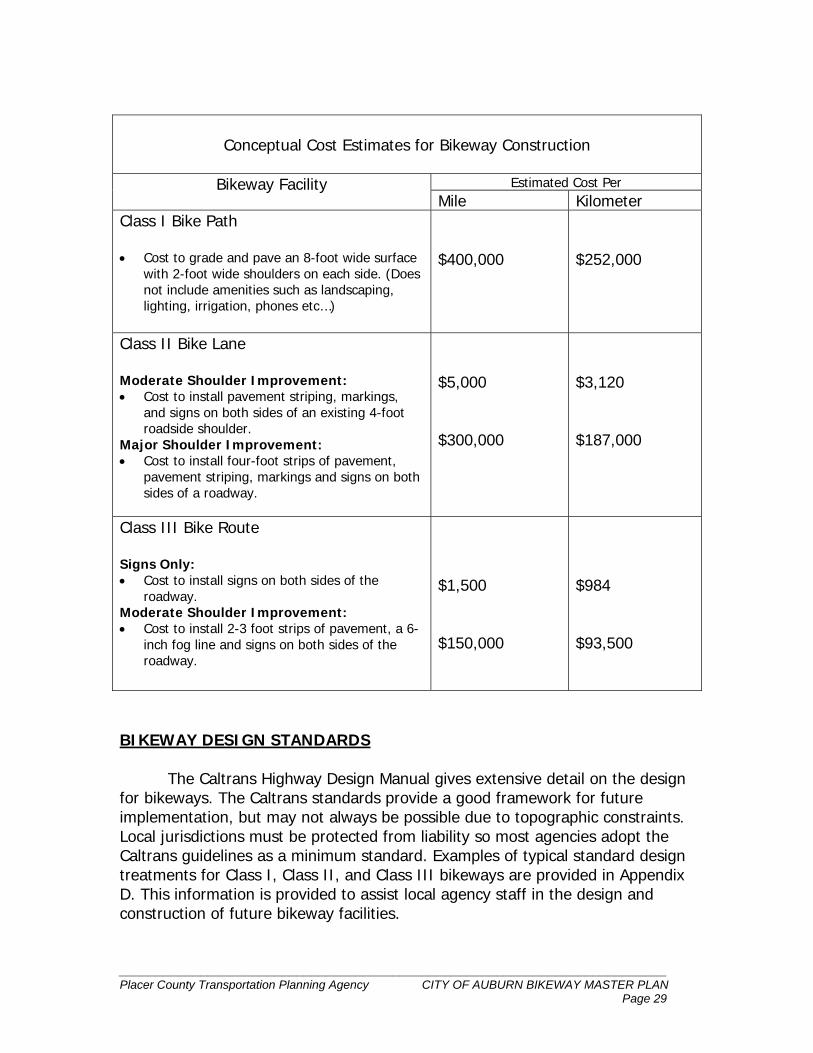
COST ESTIMATES The table below provides a conceptual cost estimate summary for constructing bikeways included in the proposed network. These cost estimates are based on costs experienced in various other California communities and previous bikeway expenditures in Placer and other counties. Due to variances in the nature of individual projects, these estimates should be used only to develop generalized construction cost estimates and project priorities. More detailed estimates should be developed after preliminary engineering is complete for each project.
__________________________________________________________________________ Placer County Transportation Planning Agency CITY OF AUBURN BIKEWAY MASTER PLAN Page 29
Conceptual Cost Estimates for Bikeway Construction
Estimated Cost Per Bikeway Facility Mile Kilometer
Class I Bike Path • Cost to grade and pave an 8-foot wide surface
with 2-foot wide shoulders on each side. (Does not include amenities such as landscaping, lighting, irrigation, phones etc…)
$400,000
$252,000
Class II Bike Lane Moderate Shoulder Improvement: • Cost to install pavement striping, markings,
and signs on both sides of an existing 4-foot roadside shoulder.
Major Shoulder Improvement: • Cost to install four-foot strips of pavement,
pavement striping, markings and signs on both sides of a roadway.
$5,000 $300,000
$3,120 $187,000
Class III Bike Route Signs Only: • Cost to install signs on both sides of the
roadway. Moderate Shoulder Improvement: • Cost to install 2-3 foot strips of pavement, a 6-
inch fog line and signs on both sides of the roadway.
$1,500 $150,000
$984 $93,500
BIKEWAY DESIGN STANDARDS The Caltrans Highway Design Manual gives extensive detail on the design for bikeways. The Caltrans standards provide a good framework for future implementation, but may not always be possible due to topographic constraints. Local jurisdictions must be protected from liability so most agencies adopt the Caltrans guidelines as a minimum standard. Examples of typical standard design treatments for Class I, Class II, and Class III bikeways are provided in Appendix D. This information is provided to assist local agency staff in the design and construction of future bikeway facilities.
__________________________________________________________________________ Placer County Transportation Planning Agency CITY OF AUBURN BIKEWAY MASTER PLAN Page 30
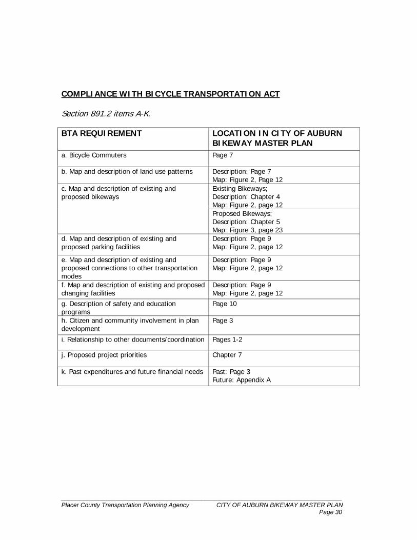
COMPLIANCE WITH BICYCLE TRANSPORTATION ACT Section 891.2 items A-K. BTA REQUIREMENT LOCATION IN CITY OF AUBURN
BIKEWAY MASTER PLAN a. Bicycle Commuters Page 7
b. Map and description of land use patterns Description: Page 7
d. Map and description of existing and proposed parking facilities
Description: Page 9 Map: Figure 2, page 12
e. Map and description of existing and proposed connections to other transportation modes
Description: Page 9 Map: Figure 2, page 12
f. Map and description of existing and proposed changing facilities
Description: Page 9 Map: Figure 2, page 12
g. Description of safety and education programs
Page 10
h. Citizen and community involvement in plan development
Page 3
i. Relationship to other documents/coordination Pages 1-2
j. Proposed project priorities
Chapter 7
k. Past expenditures and future financial needs Past: Page 3 Future: Appendix A
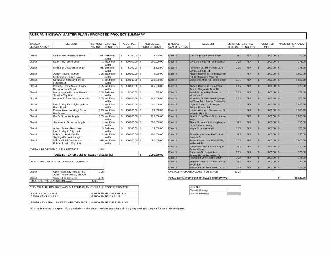
Appendix A Auburn Bikeway Master Plan Project Summary Sheet
AUBURN BIKEWAY MASTER PLAN : PROPOSED PROJECT SUMMARY
BIKEWAY CLASSIFICATION
SEGMENT DISTANCE IN MILES
EXISTING CONDITION
*COST PER MILE
*INDIVIDUAL PROJECT TOTAL
BIKEWAY CLASSIFICATION
SEGMENT DISTANCE IN MILES
EXISTING CONDITION
*COST PER MILE
*INDIVIDUAL PROJECT TOTAL
Class II Earhart Ave. within City Limits 0.5 Sufficient Width
5,000.00$ 2,500.00$ Class III Oak Ridge Way, entire length 0.5 N/A 1,000.00$ 750.00$
Class II Dairy Road, entire length 1 Insufficient Width
300,000.00$ 300,000.00$ Class III Crystal Springs Rd., entire length 0.25 N/A 1,000.00$ 375.00$
Class II Mikkelsen Drive, entire length 0.5 Sufficient Width
5,000.00$ 2,500.00$ Class III Princeton Dr., Bill Francis Dr. to Crystal Springs Rd.
0.25 N/A 1,000.00$ 375.00$
Class II Auburn Ravine Rd. from Mikkelsen Dr. to Elm Ave.
0.25 Insufficient Width
300,000.00$ 75,000.00$ Class III Auburn Ravine Rd. from Bowman Rd. to Marguerite Mine Rd.
1 N/A 1,000.00$ 1,000.00$
Class II Nevada St. from City Limit to Fulweiler St.
1 Insufficient Width
300,000.00$ 300,000.00$ Class III Marguerite Mine Rd., entire length 0.75 N/A 1,000.00$ 1,000.00$
Class II Palm Ave. from Auburn Ravine Rd. to Nevada Street
0.75 Insufficient Width
300,000.00$ 225,000.00$ Class III Auburn Ravine Rd. from Palm Ave. to Marguerite Mine Rd.
0.25 N/A 1,000.00$ 375.00$
Class II Mount Vernon Rd. from Nevada Street to City Limit
0.25 Sufficient Width
5,000.00$ 1,250.00$ Class III Walsh St. from High Street to McKenzie Ct.
0.25 N/A 1,000.00$ 375.00$
Class II Nevada St. from Fulweiler to I-80 0.75 Insufficient Width
300,000.00$ 225,000.00$ Class III Mckenzie Ct. Directional signage to Elm/Auburn Ravine Crosswalk
0.25 N/A 1,000.00$ 375.00$
Class II Lincoln Way from Highway 49 to Flood Road
1 Insufficient Width
300,000.00$ 300,000.00$ Class III High St. from Lincoln Way to Auburn Folsom Rd.
1 N/A 1,000.00$ 1,000.00$
Class II Pleasant Ave. from High St. to Pacific Ave.
0.25 Insufficient Width
300,000.00$ 75,000.00$ Class III Lincoln Way from Sacramento St. to North High St.
1 N/A 1,000.00$ 1,000.00$
Class II Pacific St., entire length 0.75 Insufficient Width
300,000.00$ 225,000.00$ Class III Pine St. from Walsh St. to Lincoln Way
1 N/A 1,000.00$ 1,000.00$
Class II Sacramento St., entire length 1 Insufficient Width
300,000.00$ 300,000.00$ Class III Placer St. to and including Maple St. I-80 Overcrossing
0.5 N/A 1,000.00$ 750.00$
Class II Auburn Folsom Road from Lincoln Way to City Limit
3 Sufficient Width
5,000.00$ 15,000.00$ Class III Maple St., entire length 0.25 N/A 1,000.00$ 375.00$
Class II Maidu Dr., Riverview Dr., Skyridge Dr., entire length
2 Insufficient Width
300,000.00$ 600,000.00$ Class III Fulweiler Ave. from HWY 49 to Nevada St.
0.5 N/A 1,000.00$ 750.00$
Class II Indian Hill Rd. from Auburn Folsom Road to City Limit
0.5 Insufficient Width
300,000.00$ 150,000.00$ Class III Foresthill Ave. from Lincoln Way to Russel Rd.
0.75 N/A 1,000.00$ 1,000.00$
OVERALL PROPOSED CLASS II DISTANCE 13.5Class III Russell Rd. from Lincoln Way to
Foresthill Ave.0.5 N/A 1,000.00$ 750.00$
TOTAL ESTIMATED COST OF CLASS II BIKEWAYS: 2,796,250.00$ Class III Racetrack St. from Auburn
Folsom Rd. to Recreation Dr.0.25 N/A 1,000.00$ 375.00$
Class III Recreation Drive, entire length 0.25 N/A 1,000.00$ 375.00$ CITY OF AUBURN EXISTING BIKEWAYS SUMMARY Class III Shirland Tract Rd. from Maidu Dr.
to City Limit0.5 N/A 1,000.00$ 750.00$
Class III East Burlin Dr. from Maidu Dr. to 0.25 N/A 1,000.00$ 375.00$
Class II Ophir Road, City limits to I-80 0.25 OVERALL PROPOSED CLASS III DISTANCE 10.25
Class IIAuburn Folsom Road, Vintage Oaks Rd. to City Limit 0.75 TOTAL ESTIMATED COST OF CLASS III BIKEWAYS: 13,125.00$
TOTAL EXISTING CLASS II BIKEWAYS 1 MILE
CITY OF AUBURN BIKEWAY MASTER PLAN OVERALL COST ESTIMATE: LEGEND:Class II Bikeways
13.5 MILES OF CLASS II APPROXIMATELY $2.8 MILLION Class III Bikeways10.25 MILES OF CLASS III APPROXIMATELY $13,125
23.75 MILES OVERALL BIKEWAY IMPROVEMENTS APPROXIMATELY $2.81 MILLION
*Cost estimates are conceptual. More detailed estimates should be developed after preliminary engineering is complete for each individual project.
Appendix B California Bicycle Transportation Act
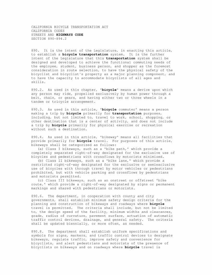
CALIFORNIA BICYCLE TRANSPORTATION ACT CALIFORNIA CODES STREETS AND HIGHWAYS CODE SECTION 890-894.2 890. It is the intent of the Legislature, in enacting this article, to establish a bicycle transportation system. It is the further intent of the Legislature that this transportation system shall be designed and developed to achieve the functional commuting needs of the employee, student, business person, and shopper as the foremost consideration in route selection, to have the physical safety of the bicyclist and bicyclist's property as a major planning component, and to have the capacity to accommodate bicyclists of all ages and skills. 890.2. As used in this chapter, "bicycle" means a device upon which any person may ride, propelled exclusively by human power through a belt, chain, or gears, and having either two or three wheels in a tandem or tricycle arrangement. 890.3. As used in this article, "bicycle commuter" means a person making a trip by bicycle primarily for transportation purposes, including, but not limited to, travel to work, school, shopping, or other destination that is a center of activity, and does not include a trip by bicycle primarily for physical exercise or recreation without such a destination. 890.4. As used in this article, "bikeway" means all facilities that provide primarily for bicycle travel. For purposes of this article, bikeways shall be categorized as follows: (a) Class I bikeways, such as a "bike path," which provide a completely separated right-of-way designated for the exclusive use of bicycles and pedestrians with crossflows by motorists minimized. (b) Class II bikeways, such as a "bike lane," which provide a restricted right-of-way designated for the exclusive or semiexclusive use of bicycles with through travel by motor vehicles or pedestrians prohibited, but with vehicle parking and crossflows by pedestrians and motorists permitted. (c) Class III bikeways, such as an onstreet or offstreet "bike route," which provide a right-of-way designated by signs or permanent markings and shared with pedestrians or motorists. 890.6. The department, in cooperation with county and city governments, shall establish minimum safety design criteria for the planning and construction of bikeways and roadways where bicycle travel is permitted. The criteria shall include, but not be limited to, the design speed of the facility, minimum widths and clearances, grade, radius of curvature, pavement surface, actuation of automatic traffic control devices, drainage, and general safety. The criteria shall be updated biennially, or more often, as needed. 890.8. The department shall establish uniform specifications and symbols for signs, markers, and traffic control devices to designate bikeways, regulate traffic, improve safety and convenience for bicyclists, and alert pedestrians and motorists of the presence of bicyclists on bikeways and on roadways where bicycle travel is
permitted. 891. All city, county, regional, and other local agencies responsible for the development or operation of bikeways or roadways where bicycle travel is permitted shall utilize all minimum safety design criteria and uniform specifications and symbols for signs, markers, and traffic control devices established pursuant to Sections 890.6 and 890.8. 891.2. A city or county may prepare a bicycle transportation plan, which shall include, but not be limited to, the following elements: (a) The estimated number of existing bicycle commuters in the plan area and the estimated increase in the number of bicycle commuters resulting from implementation of the plan. (b) A map and description of existing and proposed land use and settlement patterns which shall include, but not be limited to, locations of residential neighborhoods, schools, shopping centers, public buildings, and major employment centers. (c) A map and description of existing and proposed bikeways. (d) A map and description of existing and proposed end-of-trip bicycle parking facilities. These shall include, but not be limited to, parking at schools, shopping centers, public buildings, and major employment centers. (e) A map and description of existing and proposed bicycle transport and parking facilities for connections with and use of other transportation modes. These shall include, but not be limited to, parking facilities at transit stops, rail and transit terminals, ferry docks and landings, park and ride lots, and provisions for transporting bicyclists and bicycles on transit or rail vehicles or ferry vessels. (f) A map and description of existing and proposed facilities for changing and storing clothes and equipment. These shall include, but not be limited to, locker, restroom, and shower facilities near bicycle parking facilities. (g) A description of bicycle safety and education programs conducted in the area included within the plan, efforts by the law enforcement agency having primary traffic law enforcement responsibility in the area to enforce provisions of the Vehicle Code pertaining to bicycle operation, and the resulting effect on accidents involving bicyclists. (h) A description of the extent of citizen and community involvement in development of the plan, including, but not limited to, letters of support. (i) A description of how the bicycle transportation plan has been coordinated and is consistent with other local or regional transportation, air quality, or energy conservation plans, including, but not limited to, programs that provide incentives for bicycle commuting. (j) A description of the projects proposed in the plan and a listing of their priorities for implementation. (k) A description of past expenditures for bicycle facilities and future financial needs for projects that improve safety and convenience for bicycle commuters in the plan area. 891.4. (a) A city or county that has prepared a bicycle transportation plan pursuant to Section 891.2 may submit the plan to the county transportation commission or transportation planning
agency for approval. The city or county may submit an approved plan to the department in connection with an application for funds for bikeways and related facilities which will implement the plan. If the bicycle transportation plan is prepared, and the facilities are proposed to be constructed, by a local agency other than a city or county, the city or county may submit the plan for approval and apply for funds on behalf of that local agency. (b) The department may grant funds applied for pursuant to subdivision (a) on a matching basis which provides for the applicant' s furnishing of funding for 10 percent of the total cost of constructing the proposed bikeways and related facilities. The funds may be used, where feasible, to apply for and match federal grants or loans. 891.5. The Sacramento Area Council of Governments, pursuant to subdivision (d) of Section 2551, may purchase, operate, and maintain callboxes on class 1 bikeways. 891.8. The governing body of a city, county, or local agency may do all of the following: (a) Establish bikeways. (b) Acquire, by gift, purchase, or condemnation, land, real property, easements, or rights-of-way to establish bikeways. (c) Establish bikeways pursuant to Section 21207 of the Vehicle Code. 892. (a) Rights-of-way established for other purposes by cities, counties, or local agencies shall not be abandoned unless the governing body determines that the rights-of-way or parts thereof are not useful as a nonmotorized transportation facility. (b) No state highway right-of-way shall be abandoned until the department first consults with the local agencies having jurisdiction over the areas concerned to determine whether the right-of-way or part thereof could be developed as a nonmotorized transportation facility. If an affirmative determination is made, before abandoning the right-of-way, the department shall first make the property available to local agencies for development as nonmotorized transportation facilities in accordance with Sections 104.15 and 887.6 of this code and Section 14012 of the Government Code. 892.2. (a) The Bicycle Transportation Account is continued in existence in the State Transportation Fund, and, notwithstanding Section 13340 of the Government Code, the money in the account is continuously appropriated to the department for expenditure for the purposes specified in Section 892.4. Unexpended moneys shall be retained in the account for use in subsequent fiscal years. (b) Any reference in law or regulation to the Bicycle Lane Account is a reference to the Bicycle Transportation Account. 892.4. The department shall allocate and disburse moneys from the Bicycle Transportation Account according to the following priorities: (a) To the department, the amounts necessary to administer this article, not to exceed 1 percent of the funds expended per year. (b) To counties and cities, for bikeways and related facilities, planning, safety and education, in accordance with Section 891.4.
892.5. The Bikeway Account, created in the State Transportation Fund by Chapter 1235 of the Statutes of 1975, is continued in effect, and, notwithstanding Section 13340 of the Government Code, money in the account is hereby continuously appropriated to the department for expenditure for the purposes specified in this chapter. Unexpended money shall be retained in the account for use in subsequent fiscal years. 892.6. The Legislature finds and declares that the construction of bikeways pursuant to this article constitutes a highway purpose under Article XIX of the California Constitution and justifies the expenditure of highway funds therefor. 893. The department shall disburse the money from the Bicycle Transportation Account pursuant to Section 891.4 for projects that improve the safety and convenience of bicycle commuters, including, but not limited to, any of the following: (a) New bikeways serving major transportation corridors. (b) New bikeways removing travel barriers to potential bicycle commuters. (c) Secure bicycle parking at employment centers, park-and-ride lots, rail and transit terminals, and ferry docks and landings. (d) Bicycle-carrying facilities on public transit vehicles. (e) Installation of traffic control devices to improve the safety and efficiency of bicycle travel. (f) Elimination of hazardous conditions on existing bikeways. (g) Planning. (h) Improvement and maintenance of bikeways. In recommending projects to be funded, due consideration shall be given to the relative cost effectiveness of proposed projects. 893.2. The department shall not finance projects with the money in accounts continued in existence pursuant to this article which could be financed appropriately pursuant to Article 2 (commencing with Section 887), or fully financed with federal financial assistance. 893.4. If available funds are insufficient to finance completely any project whose eligibility is established pursuant to Section 893, the project shall retain its priority for allocations in subsequent fiscal years. 893.6. The department shall make a reasonable effort to disburse funds in general proportion to population. However, no applicant shall receive more than 25 percent of the total amounts transferred to the Bicycle Transportation Account in a single fiscal year. 894. The department may enter into an agreement with any city or county concerning the handling and accounting of the money disbursed pursuant to this article, including, but not limited to, procedures to permit prompt payment for the work accomplished. 894.2. The department, in cooperation with county and city governments, shall adopt the necessary guidelines for implementing this article.
Appendix C Caltrans Deputy Directive DD-64
California Department of Transportation
DEPUTY DIRECTIVE NUMBER: DD-64 Effective Date: 3-26-01 Supersedes: New Title: Accommodating Non-Motorized Travel POLICY The Department fully considers the needs of non-motorized travelers (including pedestrian bicyclists and persons with disabilities) in all programming, planning, maintenance, construction, operations and project development activities and products. This includes incorporation of the best available standards in all of the Department’s practices. The Department adopts the best practice concepts in the U.S. DOT Policy Statement on “Integrating Bicycling and Walking into Transportation Infrastructure.”
DEFINITION / BACKGROUND The planning and project development process seeks to provide the people of California with a degree of mobility that is in balance with other values. They must ensure that economic, social and environmental effects are fully considered along with technical issues, so that the best interest of the public is served. This includes all users of California’s facilities and roadways. Attention must be given to many issues including, but not limited to, the following:
Safe and efficient transportation for all users of the transportation system
Provision of alternatives for non-motorized travel
Support of the Americans With Disabilities Act (ADA)
Attainment of community goals and objectives
Transportation needs of low-mobility, disadvantaged groups
Support of the state's economic development
Elimination or minimization of adverse effects on the environment, natural resources, public services, aesthetic features and the community
Realistic financial estimates
Cost effectiveness
Individual projects are selected for construction on the basis of overall multimodal system benefits as well as community goals, plans and values. Decisions place emphasis on making different transportation modes work together safely and effectively. Implicit in these objectives is
the need to accommodate non-motorized travelers as an important consideration in improving the transportation system.
RESPONSIBILITIES Deputy Director, Planning and Modal Programs:
Ensures that the needs of non-motorized travelers are incorporated into the program element of Transportation Planning and the modal elements of the statewide strategy for mobility.
Ensures that liaison exists with non-motorized advocates to incorporate non-motorized needs into all program areas including project and system planning.
Ensures that the needs of the non-motorized travelers are incorporated in personal movement strategies.
Deputy Director, Project Delivery:
Ensures that projects incorporate best practices for non-motorized travel in the design and construction of capital projects.
Deputy Director, Maintenance and Operations:
Ensures that the transportation system is maintained and operated in a safe and efficient manner with the recognition that non-motorized travel is a vital element of the transportation system.
Ensures that the needs of non-motorized travelers are met in maintenance work zones. District Directors:
Ensure that best practices for non-motorized travel are included in all district projects and project planning.
Ensure that best practices for non-motorized travel are implemented in maintenance and travel operations practices.
Chief, Division of Design
Ensures that project delivery procedures and design guidance include the needs of non-motorized travelers as a regular part of doing business.
Ensures that all project delivery staff is trained and consider the needs of the non-motorized traveler while developing and designing transportation projects.
Chief, Division of Planning:
Ensures incorporation of non-motorized travel elements in transportation plans, programs and studies prepared by Transportation Planning.
Ensures planning staff understand and are trained in the principles and design guidelines, non-motorized funding sources and the planning elements of non-motorized transportation.
Coordinates Caltrans projects with non-motorized interest groups. Ensures incorporation of non-motorized travel elements in Corridor Studies prepared by
Transportation Planning. Chief, Division of Environmental Analysis:
Ensures that non-motorized travel groups potentially affected by Caltrans projects are identified and have the opportunity to be involved in the project development process.
Advocates effectively for all reasonable project-specific best practices that support or promote non-motorized travel.
Chief, Division of Maintenance:
Ensures State-owned facilities are maintained consistent with the needs of motorized and non-motorized travelers.
Provides guidance and training to those maintaining roadways to be aware of and sensitive to the needs of non-motorized travel.
Chief, Division of Traffic Operations:
Ensures that the transportation system is operated in accordance with the needs of all travelers including non-motorized travel.
Provides training and guidance on the operation of the transportation facility consistent with providing mobility for all users.
Recommends safety measures in consideration of non-motorized travel on California's transportation system.
Chief, Division of Local Assistance:
Ensures that Local Assistance staff, local agencies and interest groups are familiar with funding programs that are available for non-motorized travelers.
Ensures that program coordinators responsible for non-motorized travel modes are familiar with non-motorized issues and advocate on behalf of non-motorized travelers.
APPLICABILITY All Caltrans employees who are involved in the planning, design, construction, maintenance and operations of the transportation system. TONY V. HARRIS Chief Deputy Director http://www.cabobike.org/policy/caltransdirective.pdf
Appendix D Bikeway Design Diagrams from Highway Design Manual
Appendix E Public Comment Summary
CITY OF AUBURN BIKEWAY MASTER PLAN Public Meeting, Public Comment Summary February 20, 2002
Plan supports 2002 Vision for Auburn.
The Community Character and Culture discussion in the 2020 Vision for Greater Auburn supports in-town recreational pathways, and both local and regional cycling routes. Additionally the transportation goals support the promotion and development of alternative forms of transportation such as cycling and walking.
The intersection at Nevada, I-80, and Placer Streets will be identified as an important crossing, as the merging traffic from I-80 to both Placer Street and I-80 does not stop.
Consider Making Auburn Ravine Rd. a Class II. (2 comments)
The nature of the roadway does not allow room for the four-foot wide shoulder requirements of a Class II Bikeway. Other issues provide barriers including lack of right of way and environmental issues associated with the creek and hillside. The City will take steps to provide additional width to the extent feasible as overlays and irrigation improvements occur.
Walsh St. tunnel at I-80 underpass needs appropriate signage at tunnel
entrance and markings on roadway inside tunnel. (Tunnel is narrow and dark)
The City will ensure installation of appropriate signage at both tunnel entrances.
Utilize Auburn Dam Road as a connector between Maidu Drive and Pacific
Street - make gates bike friendly.
Auburn Dam Road is not within the City of Auburn jurisdiction.
Investigate a Class I along Auburn Ravine between Church Street and Marguerite Mine Road.
The location is primarily private property, and is too short to serve as an effective Bikeway
Public Meeting, Public Comment Summary February 20, 2002 Page 2
Investigate the potential for a bicycle and/or pedestrian pathway along Auburn Ravine.
A Class I bicycle facility must be 8 feet wide with 2 foot graded shoulders. Auburn Ravine provides little room for accommodation of a Class I path, as residents are fairly close to the ravine and there is little room to allow for the Class I requirement of 4 feet of separation from the roadway. A pedestrian walkway could be pursued as part of a Pedestrian Master Plan for the City of Auburn, if one is prepared.
Substitute AC dikes with asphalt ditches along Class II bikeways Asphalt ditches limit the ability to widen the shoulder. Shoulder space is often limited and could be used more efficiently with the installation of piping embedded under the bikeway. Additionally, AC Dikes provide for hillside erosion protection and prevent erosion materials from falling into the roadway shoulder.
Investigate a Class I Path between Awali Heights neighborhood and Auburn Folsom Road.
The Baltimore Ravine area is currently undeveloped. The City of Auburn will consider a Class I in this location as part of a specific plan if one is developed for this area.
Use flexible fiberglass road markers in place of steel posts.
The City of Auburn does not currently use metal paddle markers.
Ophir Road near I-80 under crossing: The Bike Lane abruptly cuts off and
bicyclists are forced into the gutter in a considerably narrow turn.
With the addition of a small amount of asphalt, the Bike Lane striping could be extended to guide cyclists onto what currently exists as somewhat of a sidewalk. It is unlikely that this will force bikes and pedestrians onto the same facility, as there is little or no pedestrian traffic in this location. Alternatively, the sidewalk could be removed and asphalt installed to continue the bike lane. The project has been included in the City of Auburn Bikeway Master Plan.