19
City of Crystal, Minnesota Quiet Zone Notice of Intent Canadian Pacific Paynesville Subdivision From Milepost 6.94 to 7.09 City of Crystal, Minnesota April 4, 2016 SRF No. 9084
City of Crystal, Minnesota Quiet Zone Notice of Intent Canadian Pacific Paynesville Subdivision From Milepost 6.94 to 7.09
City of Crystal, Minnesota
April 4, 2016
SRF No. 9084
Introduction This Quiet Zone Notice of Intent (Notice) is being submitted on behalf of the City of Crystal, Minnesota. The proposed quiet zone is located on the Paynesville Subdivision of the SOO Line/Canadian Pacific Railroad (CP). The proposed quiet zone will include two public at-grade crossings at Douglas Drive and West Broadway Avenue (County Road 8) in the City of Crystal. Hennepin County is the public authority responsible for each of these crossings. The City has been in close coordination with the County regarding the proposed quiet zone improvements.
The City has been in coordination with a number of organizations during this effort including the Federal Railroad Administration (FRA), CP, Hennepin County, and the Minnesota Department of Transportation (MnDOT). The meeting minutes from a January 7, 2016 diagnostic meeting with representatives from these organizations are included in Attachment A.
All affected parties have the opportunity to submit information or comments within 60 days of the date of this Notice. Please submit all information and/or comments to John Sutter, City of Crystal Community Development Director, who will serve as the point of contact for this project. John Sutter can be reached by telephone at 763-531-1130 or by email at [email protected]. Additional contact information is included at the end of this Notice.
List of Crossings within the quiet zone Quiet Zone Name: City of Crystal, MN Quiet Zone
The current train volumes through the corridor are 24 trains per day at a maximum speed of 25 MPH. The proposed quiet zone crossings, including the USDOT crossing ID numbers and the most recent daily traffic volumes are summarized in Table 1. All traffic volumes were collected in June 2015. The locations of the proposed quiet zone crossings are shown in Figure 1.
Table 1. Proposed Quiet Zone Crossings
Crossing Name USDOT Crossing ID Average Daily Traffic
Douglas Drive (County Road 102) 688953S 8,357
West Broadway Avenue (County Road 8) 688952K 7,268
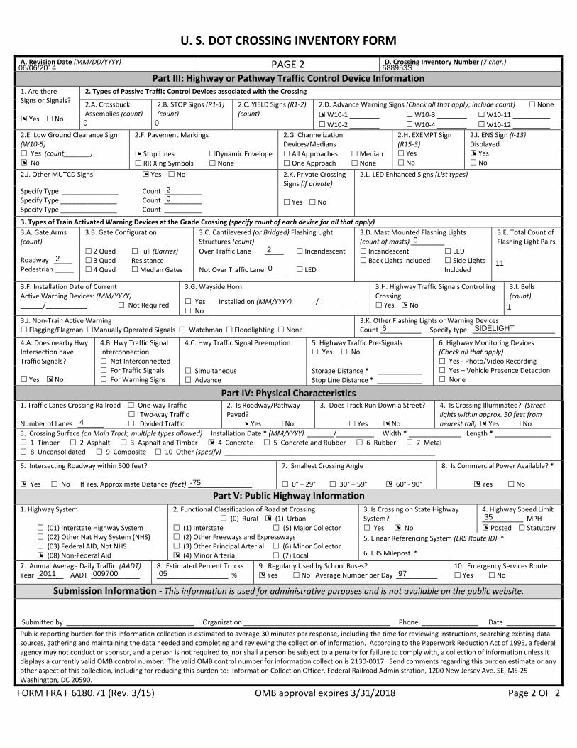
The current version of the USDOT grade crossing inventory forms for these crossing are included in Attachment B. They have been updated to reflect current traffic volumes and warning devices. There have been no accidents or incidents at any of the crossings in the last five years.
Crystal, Minnesota Quiet Zone Notice of Intent 1 SRF Consulting Group, Inc.

Figure 1. Proposed Quiet Zone Crossings
Minimum Quiet Zone Requirements According to the FRA’s Train Horn Rule, each public crossing in a new quiet zone must be equipped with gates and flashing lights with power out indicators. The Rule also requires that crossings be equipped with constant warning time (CWT) detectors where reasonably practical. All crossings in the proposed quiet zone are equipped with the requisite gates, flashing lights, and CWT detectors. While the current FRA grade crossing inventory forms indicate that the crossings are not equipped with CWT detection, the installation of CWT was confirmed by CP on site at the diagnostic meeting.
Time Period Restrictions Train horns will be restricted at this this quiet zone 24 hours per day.
Quiet Zone Implementation Plan The City intends to qualify for quiet zone implementation under regulator provision 222.39(b)(1) by implementing Alternative Safety Measures (ASMs) at the Douglas Drive and West Broadway Avenue crossings. The City will seek quiet zone approval for the risk reduction to be accorded to the ASMs from the FRA through the Quiet Zone Application process.
Douglas Drive (688953S)
The City has proposed a reduced length 20-foot non-traversable median to the south of the crossing. This median length is limited by both the proximity of 51st Place and the need to maintain the pedestrian crosswalk from the northwest to the northeast corners of the intersection. The City has proposed an 84-foot non-traversable median to the north of the crossing. A commercial business access to the north prevents a full 100-foot median north of the crossing. This improvement qualifies as an ASM under the Train Horn Rule due to the reduced-length median to the south of the crossing. The use of this ASM will require the submittal of a Quiet Zone Application. Advance warning signs and pavement markings will also be installed compliant with the Manual on Uniform Traffic Control Devices (MUTCD). A layout of the proposed improvements is shown in Figure 2.
Crystal, Minnesota Quiet Zone Notice of Intent 3 SRF Consulting Group, Inc.
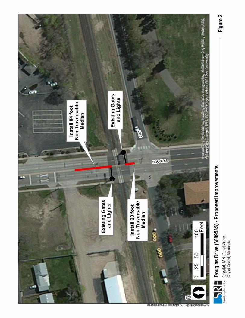
Figure 2. Douglas Drive - Proposed Improvements

West Broadway Avenue (688952K)
The City has proposed a 68-foot median to the north of the crossing. A longer median is not possible due to the proximity of Hanson Court. Approximately 18 feet of this median will be located between the gate arm and the tracks. The City will request that 50 feet of this median be counted for risk reduction purposes during the Quiet Zone Application process.
The City has proposed a 35-foot median to the south of the crossing. A longer median is not possible due to the proximity of 51st Place. Approximately half of this median will be located between the gate arm and the tracks. While this median will be effective in preventing eastbound left turn movements onto West Broadway Avenue, the proximity of 51st Place prevents the use of risk reduction credit for the southern median. The City will assume that there is no risk reduction credit for the southern median during the Quiet Zone Application process.
With the placement of this median, the eastbound to northbound left turn movement will no longer be allowed at this intersection. All other turning movements will remain open. In order to allow for a northbound left turn movement, the southern median will not be long enough to physically prevent motorists from making an eastbound left turn. However, the placement of the median will make this movement more difficult. Following the standards and guidance in the Minnesota Manual on Uniform Traffic Control Devices (MUTCD), left turn movement prohibition signs (R3-2) will be placed on the eastbound approach. One sign will be placed below the stop sign at the intersection and another will be placed 100-200 feet in advance of the intersection. Violations of this turning restriction are not anticipated to be a concern. The City reviewed 12 hours of video footage at this intersection (7 a.m. – 7 p.m.) and found that only 28 vehicles (9 percent of approach volume) made an eastbound left turn during this time frame. City police will monitor traffic flow at this intersection and enforce the turning restriction by issuing warnings and citations as necessary.
These improvements qualify as an ASM under the Train Horn Rule due to the reduced-length medians on each side of the crossing. Advance warning signs and pavement markings will also be installed compliant with the (MUTCD). A layout of the proposed improvements is shown in Figure 3.
Crystal, Minnesota Quiet Zone Notice of Intent 5 SRF Consulting Group, Inc.

Figure 3. Broadway Improvements - Proposed Improvements

Point of Contact Information Quiet Zone Name: City of Crystal, MN Quiet Zone
Date: April 4, 2016
The following individual is responsible for monitoring compliance with §222:
Name: John Sutter Title: Community Development Director Organization: City of Crystal Address: 4141 Douglas Drive Crystal, MN 55422-1696 Phone: 763-531-1130 Email: [email protected]
Notification List Notice of this Quiet Zone Notice of Intent was provided to the following individuals:
Name: Robert Lauby Title: Associate Administrator for Safety Organization: Federal Railroad Administration Address: 1200 New Jersey Avenue Washington, DC 20590 Name: Tammy Wagner Title: Regional Crossing Manager Organization: Federal Railroad Administration Address: 200 West Adams Street, Suite 310 Chicago, IL 60606 Name: Ronald Ries Title: Staff Director – Highway Rail Crossing and Trespasser Division Organization: Federal Railroad Administration Address: 1200 New Jersey Avenue, Mail Stop 25 Washington, DC 20590 Name: Tom Domres Title: Regional Crossing and Trespasser Manager Organization: Federal Railroad Administration Address: 3651 Glenhurst Ave S St. Louis Park, MN 55416
Crystal, Minnesota Quiet Zone Notice of Intent 7 SRF Consulting Group, Inc.
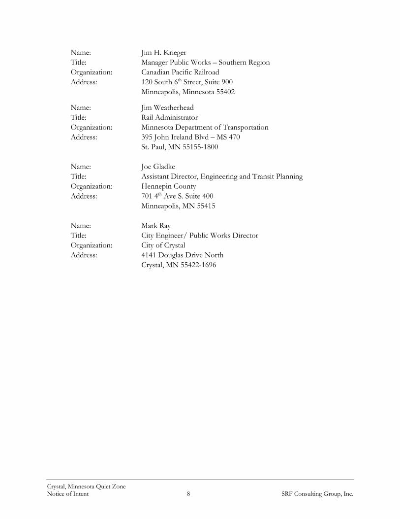
Name: Jim H. Krieger Title: Manager Public Works – Southern Region Organization: Canadian Pacific Railroad Address: 120 South 6th Street, Suite 900 Minneapolis, Minnesota 55402
Name: Jim Weatherhead Title: Rail Administrator Organization: Minnesota Department of Transportation Address: 395 John Ireland Blvd – MS 470 St. Paul, MN 55155-1800 Name: Joe Gladke Title: Assistant Director, Engineering and Transit Planning Organization: Hennepin County Address: 701 4th Ave S. Suite 400 Minneapolis, MN 55415 Name: Mark Ray Title: City Engineer/ Public Works Director Organization: City of Crystal Address: 4141 Douglas Drive North Crystal, MN 55422-1696
Crystal, Minnesota Quiet Zone Notice of Intent 8 SRF Consulting Group, Inc.

Attachment A:
January 7, 2016 Diagnostic Meeting Summary

SRF No.9084
1
CRYSTAL, MN
QUIET ZONE DIAGNOSTIC MEETING
MEETING MINUTES
January 7, 2015
ATTENDEES:
John Sutter, City of Crystal
Mark Ray, City of Crystal
Joe Gladke, Hennepin County
Jim Weatherhead, MnDOT
Tom Domres, FRA
Tammy Wagner, FRA
Jim H. Krieger, CP
Andy Mielke, SRF Consulting
Michael Palermo, SRF Consulting
The diagnostic meeting participants, including representatives from the City of Crystal, the Federal
Railroad Administration (FRA), Hennepin County, Canadian Pacific (CP), and the Minnesota
Department of Transportation (MnDOT), met at the City of Crystal Public Works Building to
discuss the steps necessary to implement a quiet zone in the City of Crystal under the FRA’s Train
Horn Rule. A copy of the sign-in sheet with contact information is provided as an attachment.
The meeting began with introductions and a brief project overview. The purpose of the meeting
was to investigate and gather input on the various Supplemental Safety Measure (SSM) and
Alternative Safety Measure (ASM) options available at each crossing in the proposed quiet zone.
The quiet zone diagnostic meeting is also an opportunity to identify any other concerns or issues
related to the crossings such as safety, traffic operations, etc.
Two public crossings, located along the Canadian Pacific Railroad at West Broadway Avenue and
Douglas Drive were identified for review. Meeting packets were distributed to the diagnostic team.
The packets included the following materials:
1. 8.5x11 aerial map showing the locations of the railroad and proposed quiet zone crossings
2. 8.5x11 aerial maps showing the layout of each crossing
3. United States Department of Transportation (USDOT) grade crossing inventory forms for
each of the crossings
4. A blank evaluation sheet for the diagnostic team members to document their preferred
SSM/ASM improvement options and other field notes
FRA crash reports for both of the crossings were also collected and made available. However,
since no crashes have occurred within the last five years, these reports were not included in the
diagnostic packet. The FRA’s risk calculation formulas consider only crashes occurring within a
five-year timeframe. SRF explained that each crossing meets the minimum quiet zone
requirements of gates, lights, and constant warning time (CWT) detection. The FRA Inventory

Crystal, MN Quiet Zone Page 2
Diagnostic Team Meeting Minutes
Form indicated motion detector circuitry. However, CWT was confirmed on site to be installed at
both crossings.
A summary of the notes, discussion items, and recommended improvements for each crossing is
provided in the tables on the following pages. General comments from the meeting that apply to
all crossings are as follows:
1. The U.S. DOT Crossing Inventory Form was corrected. The maximum time table speed is
25 MPH not 15 MPH. There are 24 trains running on the line with 12 during the day and
12 at night.
2. The City of Crystal asked if the rear train speed was an issue as opposed to the head of the
train. It was clarified that the current standards for the area do not allow an increase of
speed until the rear of the train crosses the switch. From a quiet zone perspective only the
head speed is important.
3. Either channelization devices or non-traversable medians were identified as the preferred
crossing improvement type for these crossing. Other improvement options were discussed
but determined to be unsuitable or undesirable.
a. In the case of non-traversable medians, the diagnostic team recommended a height
of eight to ten inches rather than the required six. If any portion of the median is
found to be less than six inches, the median will not be compliant with the Train
Horn Rule. The extra height allows for some degree of contractor error and provides
space for a roadway overlay without affecting the effectiveness of the medians.
The next steps of the quiet zone implementation process were also reviewed. Following the
diagnostic meeting, CP and the City will work to identify the appropriate crossing improvements
at each crossing necessary to qualify for a quiet zone. If the quiet zone moves forward, a Notice of
Intent will be submitted to all stakeholders providing an overview of the proposed improvements.
This notice is subject to a 60-day review period. Due to the close proximity of public roadways at
some of the crossings, it is anticipated that ASM crossing improvements will be used, requiring
the submittal of a Quiet Zone Application to the FRA. This application must be reviewed by the
FRA’s Railroad Safety Board and the processing time is currently estimated at six to nine months.
Construction of the improvements typically occurs following FRA approval of this application.
Construction may occur prior to approval, but any modifications required by the FRA would need
to be incorporated. Once the Quiet Zone Application is approved and the crossing improvements
are installed, a Notice of Quiet Zone Establishment will be submitted to all stakeholders. The quiet
zone will go into effect 21 days after this notice.

Crystal, MN Quiet Zone Page 3
Diagnostic Team Meeting Minutes
West Broadway Avenue FRA Crossing ID: 688952K Crossing Improvement Options (Rank Top 3):
SSM
s:
2 4-Quadrant Gate Non-Traversable Medians Channelized Delineators Wayside Horns Closure One-Way Streets
ASM
s:
3-Quadrant Gate 1 Reduced Length Non-Traversable Medians Reduced Length Channelized Delineators Other (Describe):
No Treatment
Notes:
Crossing was confirmed to have CWT.
North side of the crossing would allow for 68’ median before a commercial access.
A left-in, right-in-right-out is suggested for 51st Place due to the skewed crossing. This will prevent drivers from turning from 51st Place (EB to NB) to circumvent the gates.
A median is proposed south of the crossing to provide additional safety benefits while still providing westbound access to 51st Place.
If left turn mitigation cannot be achieved with a ¾ median restriction, MnDOT recommends that 4-Quadrant gates be installed at the West Broadway Crossing.
Douglas Drive FRA Crossing ID: 688953S Crossing Improvement Options (Rank Top 3):
SSM
s:
4-Quadrant Gate Non-Traversable Medians Channelized Delineators Wayside Horns Closure One-Way Streets
ASM
s:
3-Quadrant Gate 1 Reduced Length Non-Traversable Medians Reduced Length Channelized Delineators Other (Describe):
No Treatment
Notes:
Crossing was confirmed to have CWT.
North side of the crossing would allow for 84’ median before a commercial access.
South side of the crossing would allow for 31’ median/channelized device due to the proximity of 51st Place. This length qualifies only as an ASM, requiring a Quiet Zone
Application. MnDOT noted that they will be reconstructing the crossing in 2017. It will follow the
current layout.


Attachment B:
USDOT Crossing Inventory Forms
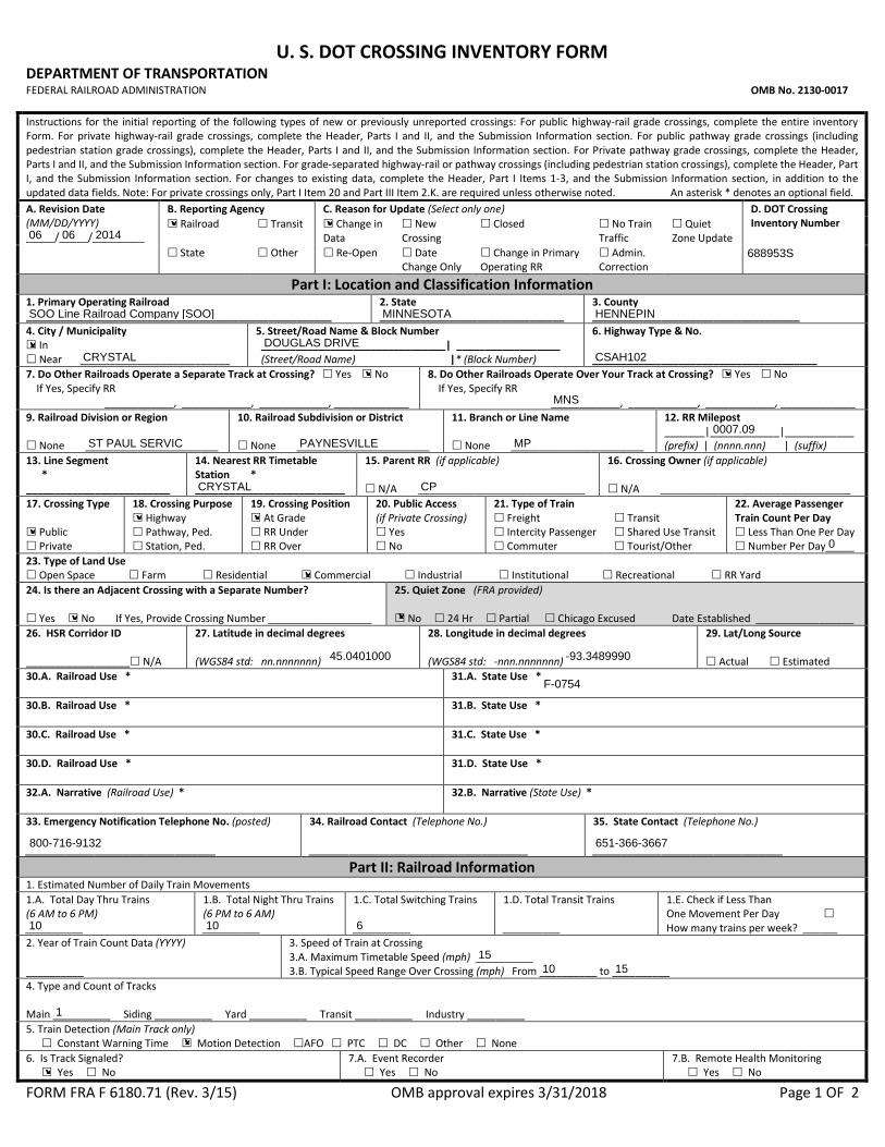
U. S. DOT CROSSING INVENTORY FORM DEPARTMENT OF TRANSPORTATION FEDERAL RAILROAD ADMINISTRATION OMB No. 2130-0017 Instructions for the initial reporting of the following types of new or previously unreported crossings: For public highway-rail grade crossings, complete the entire inventory Form. For private highway-rail grade crossings, complete the Header, Parts I and II, and the Submission Information section. For public pathway grade crossings (including pedestrian station grade crossings), complete the Header, Parts I and II, and the Submission Information section. For Private pathway grade crossings, complete the Header, Parts I and II, and the Submission Information section. For grade-separated highway-rail or pathway crossings (including pedestrian station crossings), complete the Header, Part I, and the Submission Information section. For changes to existing data, complete the Header, Part I Items 1-3, and the Submission Information section, in addition to the updated data fields. Note: For private crossings only, Part I Item 20 and Part III Item 2.K. are required unless otherwise noted. An asterisk * denotes an optional field. A. Revision Date (MM/DD/YYYY) _____/_____/_________
B. Reporting Agency C. Reason for Update (Select only one) D. DOT Crossing Inventory Number Railroad Transit Change in
Data New Crossing
Closed No Train Traffic
Quiet Zone Update
State Other Re-Open Date Change Only
Change in Primary Operating RR
Admin. Correction
Part I: Location and Classification Information 1. Primary Operating Railroad _____________________________________________________
2. State ________________________________
3. County ____________________________________
4. City / Municipality In Near __________________________
5. Street/Road Name & Block Number ________________________________| __________________ (Street/Road Name) |* (Block Number)
6. Highway Type & No. _______________________________________
7. Do Other Railroads Operate a Separate Track at Crossing? Yes No If Yes, Specify RR ____________, ____________, ____________, _____________
8. Do Other Railroads Operate Over Your Track at Crossing? Yes No If Yes, Specify RR ____________, ____________, ____________, _____________
9. Railroad Division or Region None _______________________
10. Railroad Subdivision or District None _______________________
11. Branch or Line Name None _______________________
12. RR Milepost _______|____________|____________ (prefix) | (nnnn.nnn) | (suffix)
13. Line Segment * _________________________
14. Nearest RR Timetable Station * __________________________
15. Parent RR (if applicable) N/A _____________________________
16. Crossing Owner (if applicable) N/A _________________________________
17. Crossing Type Public Private
18. Crossing Purpose Highway Pathway, Ped. Station, Ped.
19. Crossing Position At Grade RR Under RR Over
20. Public Access (if Private Crossing) Yes No
21. Type of Train Freight Intercity Passenger Commuter
Transit Shared Use Transit Tourist/Other
22. Average Passenger Train Count Per Day Less Than One Per Day Number Per Day_____
23. Type of Land Use Open Space Farm Residential Commercial Industrial Institutional Recreational RR Yard 24. Is there an Adjacent Crossing with a Separate Number? Yes No If Yes, Provide Crossing Number __________________
25. Quiet Zone (FRA provided) No 24 Hr Partial Chicago Excused Date Established _________________
26. HSR Corridor ID __________________ N/A
27. Latitude in decimal degrees (WGS84 std: nn.nnnnnnn)
28. Longitude in decimal degrees (WGS84 std: -nnn.nnnnnnn)
29. Lat/Long Source Actual Estimated
30.A. Railroad Use *
31.A. State Use *
30.B. Railroad Use *
31.B. State Use *
30.C. Railroad Use *
31.C. State Use *
30.D. Railroad Use *
31.D. State Use *
32.A. Narrative (Railroad Use) *
32.B. Narrative (State Use) *
33. Emergency Notification Telephone No. (posted) _________________________________
34. Railroad Contact (Telephone No.) ______________________________________
35. State Contact (Telephone No.) _________________________________
Part II: Railroad Information 1. Estimated Number of Daily Train Movements 1.A. Total Day Thru Trains (6 AM to 6 PM) __________
1.B. Total Night Thru Trains (6 PM to 6 AM) __________
1.C. Total Switching Trains __________
1.D. Total Transit Trains __________
1.E. Check if Less Than One Movement Per Day How many trains per week? ______
2. Year of Train Count Data (YYYY) __________
3. Speed of Train at Crossing 3.A. Maximum Timetable Speed (mph) __________ 3.B. Typical Speed Range Over Crossing (mph) From __________ to __________
4. Type and Count of Tracks Main __________ Siding __________ Yard __________ Transit __________ Industry __________ 5. Train Detection (Main Track only) Constant Warning Time Motion Detection AFO PTC DC Other None 6. Is Track Signaled? Yes No
7.A. Event Recorder Yes No
7.B. Remote Health Monitoring Yes No
FORM FRA F 6180.71 (Rev. 3/15) OMB approval expires 3/31/2018 Page 1 OF 2
✘ ✘06 06 2014
688953S
SOO Line Railroad Company [SOO] MINNESOTA HENNEPIN
CRYSTALDOUGLAS DRIVE✘
CSAH102
✘ ✘
MNS
ST PAUL SERVIC PAYNESVILLE MP0007.09
CRYSTAL CP
✘
✘ ✘
0
✘
✘ ✘
45.0401000 -93.3489990
F-0754
800-716-9132 651-366-3667
10 10 6
1510 15
1
✘
✘
FORM FRA F 6180.71 (Rev. 3/15) OMB approval expires 3/31/2018 Page 2 OF 2
U. S. DOT CROSSING INVENTORY FORM
A. Revision Date (MM/DD/YYYY) PAGE 2 D. Crossing Inventory Number (7 char.)
Part III: Highway or Pathway Traffic Control Device Information 1. Are there Signs or Signals? Yes No
2. Types of Passive Traffic Control Devices associated with the Crossing
2.A. Crossbuck Assemblies (count)
2.B. STOP Signs (R1-1) (count)
2.C. YIELD Signs (R1-2) (count)
2.D. Advance Warning Signs (Check all that apply; include count) None W10-1 ________ W10-3 ________ W10-11 __________ W10-2 ________ W10-4 ________ W10-12 __________
2.E. Low Ground Clearance Sign (W10-5) Yes (count_______) No
2.F. Pavement Markings 2.G. Channelization Devices/Medians
2.H. EXEMPT Sign (R15-3) Yes No
2.I. ENS Sign (I-13) Displayed Yes No
Stop Lines RR Xing Symbols
Dynamic Envelope None
All Approaches One Approach
Median None
2.J. Other MUTCD Signs Yes No 2.K. Private Crossing Signs (if private) Yes No
2.L. LED Enhanced Signs (List types) Specify Type _______________
Specify Type _______________ Specify Type _______________
Count __________ Count __________ Count __________
3. Types of Train Activated Warning Devices at the Grade Crossing (specify count of each device for all that apply) 3.A. Gate Arms (count) Roadway _____ Pedestrian _____
3.B. Gate Configuration 3.C. Cantilevered (or Bridged) Flashing Light Structures (count)
3.D. Mast Mounted Flashing Lights (count of masts) _________
3.E. Total Count of Flashing Light Pairs
2 Quad 3 Quad 4 Quad
Full (Barrier) Resistance Median Gates
Over Traffic Lane _____ Not Over Traffic Lane _____
Incandescent LED
Incandescent Back Lights Included
LED Side Lights Included
3.F. Installation Date of Current Active Warning Devices: (MM/YYYY) ______/___________ Not Required
3.G. Wayside Horn 3.H. Highway Traffic Signals Controlling Crossing Yes No
3.I. Bells (count)
Yes No
Installed on (MM/YYYY) ______/__________
3.J. Non-Train Active Warning Flagging/Flagman Manually Operated Signals Watchman Floodlighting None
3.K. Other Flashing Lights or Warning Devices Count ___________ Specify type ______________________
4.A. Does nearby Hwy Intersection have Traffic Signals? Yes No
4.B. Hwy Traffic Signal Interconnection Not Interconnected For Traffic Signals For Warning Signs
4.C. Hwy Traffic Signal Preemption 5. Highway Traffic Pre-Signals Yes No
6. Highway Monitoring Devices (Check all that apply) Yes - Photo/Video Recording Yes – Vehicle Presence Detection None
Simultaneous Advance
Storage Distance * ____________ Stop Line Distance * ____________
Part IV: Physical Characteristics 1. Traffic Lanes Crossing Railroad One-way Traffic Two-way Traffic Number of Lanes _______ Divided Traffic
2. Is Roadway/Pathway Paved?
Yes No
3. Does Track Run Down a Street?
Yes No
4. Is Crossing Illuminated? (Street lights within approx. 50 feet from nearest rail) Yes No
5. Crossing Surface (on Main Track, multiple types allowed) Installation Date * (MM/YYYY) _______/__________ Width * ______________ Length * _______________ 1 Timber 2 Asphalt 3 Asphalt and Timber 4 Concrete 5 Concrete and Rubber 6 Rubber 7 Metal 8 Unconsolidated 9 Composite 10 Other (specify) ________________________________________________________
6. Intersecting Roadway within 500 feet? Yes No If Yes, Approximate Distance (feet) _________________
7. Smallest Crossing Angle 0° – 29° 30° – 59° 60° - 90°
8. Is Commercial Power Available? *
Yes No
Part V: Public Highway Information 1. Highway System
(01) Interstate Highway System (02) Other Nat Hwy System (NHS) (03) Federal AID, Not NHS (08) Non-Federal Aid
2. Functional Classification of Road at Crossing (0) Rural (1) Urban
(1) Interstate (5) Major Collector (2) Other Freeways and Expressways (3) Other Principal Arterial (6) Minor Collector (4) Minor Arterial (7) Local
3. Is Crossing on State Highway System? Yes No
4. Highway Speed Limit ___________ MPH Posted Statutory
5. Linear Referencing System (LRS Route ID) *
6. LRS Milepost *
7. Annual Average Daily Traffic (AADT) Year _______ AADT _____________
8. Estimated Percent Trucks ___________________ %
9. Regularly Used by School Buses? Yes No Average Number per Day ___________
10. Emergency Services Route Yes No
Submission Information - This information is used for administrative purposes and is not available on the public website.
Submitted by __________________________________ Organization _______________________________________ Phone _______________ Date _____________ Public reporting burden for this information collection is estimated to average 30 minutes per response, including the time for reviewing instructions, searching existing data sources, gathering and maintaining the data needed and completing and reviewing the collection of information. According to the Paperwork Reduction Act of 1995, a federal agency may not conduct or sponsor, and a person is not required to, nor shall a person be subject to a penalty for failure to comply with, a collection of information unless it displays a currently valid OMB control number. The valid OMB control number for information collection is 2130-0017. Send comments regarding this burden estimate or any other aspect of this collection, including for reducing this burden to: Information Collection Officer, Federal Railroad Administration, 1200 New Jersey Ave. SE, MS-25 Washington, DC 20590.
06/06/2014 688953S
✘ 0 0✘
✘✘ ✘
✘
20
22
0
011
✘ 1
6 SIDELIGHT
✘
4 ✘✘ ✘
✘
✘ -75 ✘ ✘
✘
✘
✘
35
✘
✘
2011 009700 05 ✘ 97

U. S. DOT CROSSING INVENTORY FORM DEPARTMENT OF TRANSPORTATION FEDERAL RAILROAD ADMINISTRATION OMB No. 2130-0017 Instructions for the initial reporting of the following types of new or previously unreported crossings: For public highway-rail grade crossings, complete the entire inventory Form. For private highway-rail grade crossings, complete the Header, Parts I and II, and the Submission Information section. For public pathway grade crossings (including pedestrian station grade crossings), complete the Header, Parts I and II, and the Submission Information section. For Private pathway grade crossings, complete the Header, Parts I and II, and the Submission Information section. For grade-separated highway-rail or pathway crossings (including pedestrian station crossings), complete the Header, Part I, and the Submission Information section. For changes to existing data, complete the Header, Part I Items 1-3, and the Submission Information section, in addition to the updated data fields. Note: For private crossings only, Part I Item 20 and Part III Item 2.K. are required unless otherwise noted. An asterisk * denotes an optional field. A. Revision Date (MM/DD/YYYY) _____/_____/_________
B. Reporting Agency C. Reason for Update (Select only one) D. DOT Crossing Inventory Number Railroad Transit Change in
Data New Crossing
Closed No Train Traffic
Quiet Zone Update
State Other Re-Open Date Change Only
Change in Primary Operating RR
Admin. Correction
Part I: Location and Classification Information 1. Primary Operating Railroad _____________________________________________________
2. State ________________________________
3. County ____________________________________
4. City / Municipality In Near __________________________
5. Street/Road Name & Block Number ________________________________| __________________ (Street/Road Name) |* (Block Number)
6. Highway Type & No. _______________________________________
7. Do Other Railroads Operate a Separate Track at Crossing? Yes No If Yes, Specify RR ____________, ____________, ____________, _____________
8. Do Other Railroads Operate Over Your Track at Crossing? Yes No If Yes, Specify RR ____________, ____________, ____________, _____________
9. Railroad Division or Region None _______________________
10. Railroad Subdivision or District None _______________________
11. Branch or Line Name None _______________________
12. RR Milepost _______|____________|____________ (prefix) | (nnnn.nnn) | (suffix)
13. Line Segment * _________________________
14. Nearest RR Timetable Station * __________________________
15. Parent RR (if applicable) N/A _____________________________
16. Crossing Owner (if applicable) N/A _________________________________
17. Crossing Type Public Private
18. Crossing Purpose Highway Pathway, Ped. Station, Ped.
19. Crossing Position At Grade RR Under RR Over
20. Public Access (if Private Crossing) Yes No
21. Type of Train Freight Intercity Passenger Commuter
Transit Shared Use Transit Tourist/Other
22. Average Passenger Train Count Per Day Less Than One Per Day Number Per Day_____
23. Type of Land Use Open Space Farm Residential Commercial Industrial Institutional Recreational RR Yard 24. Is there an Adjacent Crossing with a Separate Number? Yes No If Yes, Provide Crossing Number __________________
25. Quiet Zone (FRA provided) No 24 Hr Partial Chicago Excused Date Established _________________
26. HSR Corridor ID __________________ N/A
27. Latitude in decimal degrees (WGS84 std: nn.nnnnnnn)
28. Longitude in decimal degrees (WGS84 std: -nnn.nnnnnnn)
29. Lat/Long Source Actual Estimated
30.A. Railroad Use *
31.A. State Use *
30.B. Railroad Use *
31.B. State Use *
30.C. Railroad Use *
31.C. State Use *
30.D. Railroad Use *
31.D. State Use *
32.A. Narrative (Railroad Use) *
32.B. Narrative (State Use) *
33. Emergency Notification Telephone No. (posted) _________________________________
34. Railroad Contact (Telephone No.) ______________________________________
35. State Contact (Telephone No.) _________________________________
Part II: Railroad Information 1. Estimated Number of Daily Train Movements 1.A. Total Day Thru Trains (6 AM to 6 PM) __________
1.B. Total Night Thru Trains (6 PM to 6 AM) __________
1.C. Total Switching Trains __________
1.D. Total Transit Trains __________
1.E. Check if Less Than One Movement Per Day How many trains per week? ______
2. Year of Train Count Data (YYYY) __________
3. Speed of Train at Crossing 3.A. Maximum Timetable Speed (mph) __________ 3.B. Typical Speed Range Over Crossing (mph) From __________ to __________
4. Type and Count of Tracks Main __________ Siding __________ Yard __________ Transit __________ Industry __________ 5. Train Detection (Main Track only) Constant Warning Time Motion Detection AFO PTC DC Other None 6. Is Track Signaled? Yes No
7.A. Event Recorder Yes No
7.B. Remote Health Monitoring Yes No
FORM FRA F 6180.71 (Rev. 3/15) OMB approval expires 3/31/2018 Page 1 OF 2
✘ ✘06 06 2014
688952K
SOO Line Railroad Company [SOO] MINNESOTA HENNEPIN
CRYSTALW BROADWAY AVE✘
CSAH 8
✘ ✘
TCWR
ST PAUL SERVIC PAYNESVILLE MP0006.94
CRYSTAL CP
✘
✘ ✘
0
✘
✘ ✘
45.0419010 -93.3505020
F-0072B
800-716-9132 651-366-3667
10 10 0
1510 15
1
✘
✘

FORM FRA F 6180.71 (Rev. 3/15) OMB approval expires 3/31/2018 Page 2 OF 2
U. S. DOT CROSSING INVENTORY FORM
A. Revision Date (MM/DD/YYYY) PAGE 2 D. Crossing Inventory Number (7 char.)
Part III: Highway or Pathway Traffic Control Device Information 1. Are there Signs or Signals? Yes No
2. Types of Passive Traffic Control Devices associated with the Crossing
2.A. Crossbuck Assemblies (count)
2.B. STOP Signs (R1-1) (count)
2.C. YIELD Signs (R1-2) (count)
2.D. Advance Warning Signs (Check all that apply; include count) None W10-1 ________ W10-3 ________ W10-11 __________ W10-2 ________ W10-4 ________ W10-12 __________
2.E. Low Ground Clearance Sign (W10-5) Yes (count_______) No
2.F. Pavement Markings 2.G. Channelization Devices/Medians
2.H. EXEMPT Sign (R15-3) Yes No
2.I. ENS Sign (I-13) Displayed Yes No
Stop Lines RR Xing Symbols
Dynamic Envelope None
All Approaches One Approach
Median None
2.J. Other MUTCD Signs Yes No 2.K. Private Crossing Signs (if private) Yes No
2.L. LED Enhanced Signs (List types) Specify Type _______________
Specify Type _______________ Specify Type _______________
Count __________ Count __________ Count __________
3. Types of Train Activated Warning Devices at the Grade Crossing (specify count of each device for all that apply) 3.A. Gate Arms (count) Roadway _____ Pedestrian _____
3.B. Gate Configuration 3.C. Cantilevered (or Bridged) Flashing Light Structures (count)
3.D. Mast Mounted Flashing Lights (count of masts) _________
3.E. Total Count of Flashing Light Pairs
2 Quad 3 Quad 4 Quad
Full (Barrier) Resistance Median Gates
Over Traffic Lane _____ Not Over Traffic Lane _____
Incandescent LED
Incandescent Back Lights Included
LED Side Lights Included
3.F. Installation Date of Current Active Warning Devices: (MM/YYYY) ______/___________ Not Required
3.G. Wayside Horn 3.H. Highway Traffic Signals Controlling Crossing Yes No
3.I. Bells (count)
Yes No
Installed on (MM/YYYY) ______/__________
3.J. Non-Train Active Warning Flagging/Flagman Manually Operated Signals Watchman Floodlighting None
3.K. Other Flashing Lights or Warning Devices Count ___________ Specify type ______________________
4.A. Does nearby Hwy Intersection have Traffic Signals? Yes No
4.B. Hwy Traffic Signal Interconnection Not Interconnected For Traffic Signals For Warning Signs
4.C. Hwy Traffic Signal Preemption 5. Highway Traffic Pre-Signals Yes No
6. Highway Monitoring Devices (Check all that apply) Yes - Photo/Video Recording Yes – Vehicle Presence Detection None
Simultaneous Advance
Storage Distance * ____________ Stop Line Distance * ____________
Part IV: Physical Characteristics 1. Traffic Lanes Crossing Railroad One-way Traffic Two-way Traffic Number of Lanes _______ Divided Traffic
2. Is Roadway/Pathway Paved?
Yes No
3. Does Track Run Down a Street?
Yes No
4. Is Crossing Illuminated? (Street lights within approx. 50 feet from nearest rail) Yes No
5. Crossing Surface (on Main Track, multiple types allowed) Installation Date * (MM/YYYY) _______/__________ Width * ______________ Length * _______________ 1 Timber 2 Asphalt 3 Asphalt and Timber 4 Concrete 5 Concrete and Rubber 6 Rubber 7 Metal 8 Unconsolidated 9 Composite 10 Other (specify) ________________________________________________________
6. Intersecting Roadway within 500 feet? Yes No If Yes, Approximate Distance (feet) _________________
7. Smallest Crossing Angle 0° – 29° 30° – 59° 60° - 90°
8. Is Commercial Power Available? *
Yes No
Part V: Public Highway Information 1. Highway System
(01) Interstate Highway System (02) Other Nat Hwy System (NHS) (03) Federal AID, Not NHS (08) Non-Federal Aid
2. Functional Classification of Road at Crossing (0) Rural (1) Urban
(1) Interstate (5) Major Collector (2) Other Freeways and Expressways (3) Other Principal Arterial (6) Minor Collector (4) Minor Arterial (7) Local
3. Is Crossing on State Highway System? Yes No
4. Highway Speed Limit ___________ MPH Posted Statutory
5. Linear Referencing System (LRS Route ID) *
6. LRS Milepost *
7. Annual Average Daily Traffic (AADT) Year _______ AADT _____________
8. Estimated Percent Trucks ___________________ %
9. Regularly Used by School Buses? Yes No Average Number per Day ___________
10. Emergency Services Route Yes No
Submission Information - This information is used for administrative purposes and is not available on the public website.
Submitted by __________________________________ Organization _______________________________________ Phone _______________ Date _____________ Public reporting burden for this information collection is estimated to average 30 minutes per response, including the time for reviewing instructions, searching existing data sources, gathering and maintaining the data needed and completing and reviewing the collection of information. According to the Paperwork Reduction Act of 1995, a federal agency may not conduct or sponsor, and a person is not required to, nor shall a person be subject to a penalty for failure to comply with, a collection of information unless it displays a currently valid OMB control number. The valid OMB control number for information collection is 2130-0017. Send comments regarding this burden estimate or any other aspect of this collection, including for reducing this burden to: Information Collection Officer, Federal Railroad Administration, 1200 New Jersey Ave. SE, MS-25 Washington, DC 20590.
06/06/2014 688952K
✘ 0 0✘
✘✘
✘
✘
✘
10
22
0
011
✘ 1
4 SIDES
✘
4 ✘✘ ✘
✘
✘ -200 ✘ ✘
✘
✘
✘
35
✘
✘
2011 008000 05 ✘ 37


