221
FEBRUARY 2012 City Of Lethbridge Public Realm & Transportation Study FINAL REPORT SUBMITTED TO: CITY OF LETHBRIDGE
| Date post: | 14-Apr-2018 |
| Category: |
Documents |
| Upload: | truongquynh |
| View: | 217 times |
| Download: | 3 times |

february 2012
City Of LethbridgePublic Realm & Transportation Study
final report Submitted to: City of Lethbridge

Public Realm and TRansPoRTaTion sTudy foR downTown leThbRidge | mmm gRouP | febRuaRy 2012 | v 1.2 | 5210038000 i
EXECUTIVE SUMMARY
1.0 INTRODUCTION AND OVERVIEW
The Public Realm and Transportation Study
(PRATS) builds on the vision, ideas, and concepts for
Downtown development that were expressed in the
Heart of Our City Master Plan (HOCMP). PRATS
utilizing elements of New Urbanism and Sustainable
Development Planning, in harmony with interactive
community engagement and collaboration, to produce
an exciting and lively public urban space.
The study focuses on the Downtown area proposed in
the HOCMP and examines the facility requirements
for active, public realm improvements, alternative and
accessible transportation modes, freight, vehicles, and
parking in the Downtown area. An extensive design
charrette was undertaken supported by additional
stakeholder interviews to integrate stakeholder input
into the design.
Key Study objectives were identified as follows:
» Incorporate the direction from the HOCMP as a
guiding framework.
» Integrate transportation and urban design
recommendations.
» Determine 20-year requirements for pedestrians,
cyclists, moving traffic , and parking.
» Undertake a consultation and communication
process to effectively engage the key stakeholders.
» Demonstrate the value of Form Base Codes through
a relevant planning exercise.
» Produce a public realm designs for the selected
streets in the Downtown Area based on ideas
generated through the consultation process.
» Define public art opportunities within the study
area.
2.0 PRIORITY STREETS AND GENERAL AREA REVIEW
Due to the size of the Downtown area it was agreed,
during the project initiation process, that the study
would focus on selected priority corridors. The
Downtown priority corridors were identified by
assessing those streets, or blocks, that offered the
greatest short-terms gains in enhancement. In
identifying the priority areas a revised three weighted
criteria was utilized that included the following
criterion:
» The condition of the existing infrastructure,
» The potential for enhancement of the public realm,
and
» The opportunity to stimulate future development.
The priority corridors that were approved by the City’s
Project Advisory Committee (PAC) were:
» 2 Avenue S. – Scenic Drive S. to 5 Street S
» 5 Street S. – 1 Avenue S. to 6 Avenue S
» 3 Avenue S. – 4 Street S. to 8 Street S
In addition to focusing on the priority corridors the
study also included a high-level review of other key
aspects of the Downtown area. The review noted the
following:
Pedestrian Facilities
» Many of the sidewalks are not wide enough for
large volumes of pedestrians or for the comfortable
passing of wheel chair users.
» Many of the sidewalks are obstructed by fixed and
moveable obstacles such as parking meters, street
lighting, traffic lights, street signs, trees and vendor
signing.

Public Realm and TRansPoRTaTion sTudy foR downTown leThbRidge | mmm gRouP | febRuaRy 2012 | v 1.2 | 5210038000 ii
Cyclist Facilities
» 3 Avenue S is signed as a designated bike route but
the travel lane width does not allow a vehicle and
a cyclist to share the same lane and conflicts with
angle parking.
» There’s an overall lack of cycle pavement markings,
wayfinding signage or prioritisation for cycles.
» There are insufficient cycle storage facilities in the
down town area.
Roadway Analysis
» The traffic analysis shows that the existing
intersections operate at a satisfactory Level of
Service (level of service ‘LOS’ A) during the peak
periods.
Parking Conditions
» The parking analysis showed that there is sufficient
on-street and off-street parking availability and that
the mean peak demand is about 60% of capacity.
» The overall parking demand rate is between 2.10 and
2.22 spaces per 100 m2, which is consistent with the
City’s zoning by-law.
Freight Review
» Scenic Drive S is the only roadway, in the Downtown
area, that is designated as a truck route.
» Twelve hour traffic counts (7am to 7pm) show that
there are few large vehicles trying to access the
Downtown area.
» The freight survey results did not identify any
major issues regarding the freight operations in the
Downtown area.
3.0 FUTURE CONDITIONS
Future projections for the Downtown area were
incorporated to determine the conceptual designs
for the priority streets. An estimate of the future
traffic volume along the priority streets, as well as the
estimated parking demand for the Downtown area was
analysed. The main elements of the future conditions
are as follows:
2030 Traffic Analysis
» Forecast traffic is expected to grow annually by 1.7%
and active transportation is expected to increase
annually by 3%.
» All observed intersections are expected to operate at
a satisfactory Level of Service (LOS C or better) in
the 20 year time horizon.
» The future implementation of a pedestrian only
phase (scramble intersection) at 5 Street S and 3
Avenue S will increase delays, to a LOS D, but will
remain within acceptable limits.
Future Parking Conditions
» Peak parking utilization is expected to increase to
about 80%.
» Some blocks may experience a higher level of
demand, but this can be met by spare capacity in
adjacent blocks.
Future Parking Structure
» Assuming the traffic growth forecasts and
development forecasts are correct then a new public
parking structure will not be required within the
next 20 years.
» Local development would have to exceed the City’s
own plans, by an additional 115,000m2 of non-
residential gross flow area, before a public parking
structure would become viable.

Public Realm and TRansPoRTaTion sTudy foR downTown leThbRidge | mmm gRouP | febRuaRy 2012 | v 1.2 | 5210038000 iii
» If a four storey parkade were built on the Bompass
Lot then the estimated costs would be in the range of
$9M to $13M.
Land Use/Form Based Code
» Form based code regulates the physical outcome
of structures and has been demonstrated to better
implement within mixed use and pedestrian friendly
places.
» Can be used to implement the essential elements of
the HOCMP, provide guidance for shop front design
and interface between the public and private realm.
4.0 CONCEPT DEVELOPMENT
Concepts were developed, for the priority corridors, to
help achieve the vision contained within the HOCMP.
The concepts adhered to the guidelines for barrier-free
design and included recommendations for pavement
markings, curb ramps, pedestrian signals, and a future
pathway improvements.
The cyclist treatment concepts for the Downtown area
are based on the Bikeway and Pathway Master Plan.
Connectivity to the Downtown area was improved by
the specification of dedicated bike lanes and the use
of multi-modal zones. In addition, it is recommended
that the City provide additional cycle racks, lockers,
changing rooms, and shower facilities.
5.0 PUBLIC AND STAKEHOLDER CONSULTATION
As part of the stakeholder engagement MMM
organised and facilitated a four day design charrette
with key stakeholders. As well as the design charrette
additional face-to-face meetings were held and a
written survey was sent to every member of the BRZ.
During the design charrette a clear goal was developed
with stakeholders:” To create a balance between
the public realm and the traffic realm, without a
significant loss of on-street parking, and enhance the
overall quality of the Downtown’s public realm for
long term vitality and promotion of the Downtown as a
place to live, work, play, and learn.”
Much of the feedback received during the consultation
process focused on increased accessibility, safety and
facilities for vulnerable road users, specifically for
pedestrians and cyclists. There was also a concern
about a lack of connectivity, for active transportation,
with other parts of the City. Other concerns included a
lack of residential property within the Downtown core.
Some of the main themes arising from the stakeholder
engagement included a need to slow traffic down, a
need to entice families into the Downtown, a need
to enhance Galt Gardens as a key destination, and
a need to enhance cycling as an alternative mode of
transportation
As part of the consultation process MMM produced a
“Kits of Parts” toolbox for specific elements that could
be adopted along the priority streets or amended for
use on other corridors. Elements from the Kit of Parts
are shown in figure 5.5.2 and 5.5.3 in the main report.
Other key elements arising from the consultation
process include:

Public Realm and TRansPoRTaTion sTudy foR downTown leThbRidge | mmm gRouP | febRuaRy 2012 | v 1.2 | 5210038000 iv
Public Art
Opportunities for the installation of public art should
include the following:
» a primarily sculpture (5 Street S and 4 Avenue
S-Northwest Corner)
» vertical marker/gateway (5 Street S and 2 Avenue
S-Galt Gardens Plaza Entry)
» figurative representation (stone/bronze) (5 Street S
and 6 Avenue S Northwest Corner)
» relocation of the City’s historical steam locomotive
(northwest corner of Galt Gardens)
Sustainability and High Performance Streetscape
Design
In compliance with Lethbridge’s Integrated
Community Sustainability Plan (ICSP) several ‘green
initiatives’ or examples ‘best practice’ have been
identified. Some of these include:
» increase the quality, density, and diversity of urban
trees in the Downtown area
» stormwater management improvements such
as landscape improvements, permeable paving,
infiltration structures, sub-surface storage, and oil
and grit separators
» increase the sustainability of the landscape by using
local and regional plant species that are drought
tolerant
» minimize urban footprint with the use of sustainable
technologies for example, re-use structures,
environmental materials, energy conservation, and
‘Dark Sky’ principles
6.0 PRELIMINARY DESIGN
The preliminary designs, of the priority streets
complemented the vision established in the HOMP
and incorporated the key elements identified during
the consultation process. The main features of the
preliminary designs are as follows:
5 Street S
» This would become a major retail and pedestrian
corridor.
» The provision of a raised ‘scramble’ intersection is
proposed where 5 Street S meets 3 and 4 Avenue S.
» A multi-modal path is proposed along 5 Street S, to
promote alternative modes of travel.
» To create space for the multi-modal path it is
recommended that the parking on the west side be
parallel parking whilst the parking on the east side
could remain as angled parking.
2 Avenue S
» Raised on-street parking to sidewalk level and allow
for flexible use of the parking to increase the public
realm associated with building use i.e. patio space
» 2 Avenue S is envisioned as a highly pedestrian
street that visually and physically connects multi-
family buildings and the river trails located west of
Scenic Drive S with the Downtown area and Galt
Gardens.
» Vehicular movement will remain as two travel lanes
with angled parking on both sides.
» A double row of street trees will be planted on each
side of 2 Avenue S, extending the ‘green’ of Galt
Gardens to Scenic Drive.
» Intersection of 5 Street S and 2 Avenue S to be
treated with a shifted roadway at the intersection
to provide flexible space for parking and outdoor
gathering.

Public Realm and TRansPoRTaTion sTudy foR downTown leThbRidge | mmm gRouP | febRuaRy 2012 | v 1.2 | 5210038000 v
3 Avenue S
» 3 Avenue S, is a dynamic mix of historic and
contemporary architectural styles that should
provide the framework for a vibrant streetscape
treatment.
» Creation of a pedestrian promenade with a high level
of street pageantry in front of major civic spaces and
buildings.
» Provide three travel lanes that will allow for angled
parking and an enhanced sidewalk width along the
north side, which interfaces with Galt Gardens.
» Alternative concept to provide parallel parking
configuration between 7 Street S and 5 Street S will
allow for the preservation of existing mature street
trees and current sidewalk and provide 3.0m for a
multi-modal path along the north side of 3 Avenue S.
Public Realm Design Components
Several design strategies are identified in the report
with a few of these are listed below:
» Plaza intersections should have raised crosswalks,
to reduce traffic speeds and promote pedestrian
priority.
» Vary the surface texture, material and colour to
identify different zones (e.g. pedestrian, multi-
modal, and parking).
» Use a custom colour palette that reflects the natural
landscape of Lethbridge.
7.0 IMPLEMENTATION PLAN
The implementation plan helps to identify when the
works should be undertaken. Whilst the construction
process may be influenced by external factors,
such as the availability of funds, and the source of
funding, it will also be influenced by the method of
construction, the timing of construction, the phasing
of the construction, and the economic, social and
environmental considerations.
In order to aid the City in identifying the preferred
construction method, several evaluation criterion
and performance measures have been proposed. The
evaluation criterion includes consideration to:
» Social Impacts
» Environmental Impacts
» Economic Impacts
Having evaluated the various options the highest
scoring short term priority would appear to be either
the treatments identified along 2 Avenue or those
identified for 3 Avenue. The actual timing may, of
course, be determined by a sudden need to replace one
of the failing utilities that already exist within the right
of way.
The long term priority should be to reconstruct 5
Street S in two phases; the first phase from 1 Avenue S
to 4 Avenue S and the second phase from 4 Avenue S
to 6 Avenue S.

Public Realm and TRansPoRTaTion sTudy foR downTown leThbRidge | mmm gRouP | febRuaRy 2012 | v 1.2 | 5210038000 vi
8.0 CONCLUSION AND RECOMMENDATIONS
It is important to maintain the momentum generated
by the Heart of the City Master Plan and this Public
Realm and Transportation Study (PRATS). The
transportation component is recommending a change
in mindset, from the traditional ‘create more space for
motor vehicles’ , to a more balanced approach in terms
of reducing vehicular traffic lanes and reallocating
space to the public realm.
The public consultation helped to identify the
pertinent issues and the solutions most likely to gain
popular support. The conceptual designs synthesized
the recommendations to enhance the public realm
whilst satisfying the transportation needs.
The Implementation Plan recognizes the complexity
surrounding the financial, political and physical
resources needed to construct the recommended
works. It does set out a strategic approach and makes
suggestions for the prioritization of construction
of the selected study streets. Ultimately these
recommendations will need to be determined by the
City. The report’s recommendations serve as a starting
point and baseline for future discussion and planning
– with recommendations that the same level of public
consultation continues to future phases.
Future Recommendations
To build upon the ideas in the report the following
additional information and investigation should be
made prior to or as part of the detailed design:
» Detailed survey and Arborist's report to ensure
that existing trees incorporated into the design will
remain healthy.
» Further investigation into sustainable green
products and initiatives.
» Consider new signage design be coordinated as part
of a larger City of Lethbridge wayfinding signage
system.
» Standardize site furnishing and lighting within the
Downtown, based on the ‘Kit of Parts’ for common
elements that has been developed in the report.
» Public Art Committee to be consulted during the
implementation of the Public Art recommendations
identified in the report and any potential grant or
funding contributions.
» Explore the feasibility of relocating the coal fire
steam engine #3651 from behind the Medical Clinic
to Galt Gardens.
» Hydro-utility provider to be contacted during or
preceding detail design to discuss upgrading of
power service and routing for all existing and new
services.

Public Realm and TRansPoRTaTion sTudy foR downTown leThbRidge | mmm gRouP | febRuaRy 2012 | v 1.2 | 5210038000 vii
ACknowlEdgEMEnTS
The Public Realm and Transportation Study (PRATS) is an extension of the groundwork
completed in the Heart of Our City Master Plan (HOCMP).
The dynamic and exciting designs proposed within the PRATS report, were made
possible by the significant contributions provided by local land owners, businesses, local
organizations and institutions. We extend our thanks to all the support and assistance that
was given by local community groups and stakeholder groups that participated in the design
charrette and for their continuous involvement or feedback. Their contributions have helped
the consulting team identify a strategy and create a selection of streetscapes that will help
promote a strong Downtown community in the heart of Lethbridge.
The study would like to thank the City of Lethbridge and the Heart of Our City
Revitalization Committee for their guidance, support, and enthusiasm. Additionally, the
study would like to thank the elected officials, business, land owners and residents who
participated in the Design Charrette.
The Project Advisory Committee (PAC) played an essential role in the collaboration,
identification, development and refinement of the recommended streetscapes. The
members of the City of Lethbridge PAC were as follows:
Tatsuyuki Setta, Community Planner and Project Manager
Jeff Greene, Director of Planning and Development
George Kuhl, Downtown Revitalization Manager
Maureen Gaehring, Community Planning Manager
Ahmed Ali, Transportation Planning Manager
Wade Coombs, L.A Transit Strategic Planning Manager
Ryan Carriere, Parks Planning Manager
The study would also like to acknowledge the contributions from Michael Van Hausen,
President of MVH Urban Planning & Design, Geoff Dyer lead designer on Form-
Based of PlaceMakers, and public artist - Nicholas Wade Associate Professor from the
University of Lethbridge.

Public Realm and TRansPoRTaTion sTudy foR downTown leThbRidge | mmm gRouP | febRuaRy 2012 | v 1.2 | 5210038000 viii
ConTEnTS
Abbreviations and Acronyms ...................................................................................................... Viii
INTRODUCTION AND OVERVIEW ........................................................................1
1.1 Introduction ...................................................................................................................1
1.2 Study Objectives .............................................................................................................1
1.3 Background Information00 .............................................................................................3
1.4 Consultation with Community Stakeholders ....................................................................6
PRIORITY STREETS AND GENERAL AREA REVIEW ...................................................7
2.1 Selection of Downtown Study Streets ..............................................................................7
2.2 Existing Public Realm Conditions .....................................................................................8
2.3 Active Transportation ....................................................................................................11
2.3.2 Existing Cyclist Facilities ...............................................................................................15
2.3.3 Existing Pedestrian and Cyclist Survey ..........................................................................17
2.4 Road Geometry ............................................................................................................19
2.4.1 Existing Roadway Classification and Cross-Sections ......................................................19
2.4.2 Existing Intersections ...................................................................................................21
2.4.3 Existing Traffic Volumes ...............................................................................................22
2.5 2010 Intersection Capacity Analysis ..............................................................................25
2.6 Existing Transit Review ..................................................................................................28
2.7 Existing Parking Conditions ...........................................................................................32
2.7.1 Existing Parking Supply ................................................................................................32
2.7.2 Existing Parking Demands ...........................................................................................32
2.8 Freight Review ..............................................................................................................33
FUTURE CONDITIONS .......................................................................................38
3.1 Projection of the Future Traffic Volumes .........................................................................38

Public Realm and TRansPoRTaTion sTudy foR downTown leThbRidge | mmm gRouP | febRuaRy 2012 | v 1.2 | 5210038000 ix
3.1.1 Historical Traffic Volumes .............................................................................................38
3.1.2 Population Projections .................................................................................................38
3.1.3 Recommended Traffic Growth Rate ..............................................................................38
3.1.4 Future Traffic Volumes .................................................................................................38
3.2 Analysis of Future Traffic ...............................................................................................40
3.3 Future Parking Supply ...................................................................................................42
3.3.1 Future Parking Demand ..............................................................................................42
3.3.2 Public Parking Analysis ................................................................................................42
3.3.3 Future Parking Structure ..............................................................................................43
3.4 Land Use/Form Base Code Recommendations ..............................................................44
3.4.1 Background ................................................................................................................44
3.4.2 Same Rules, Different Outcome ...................................................................................44
3.4.3 Matching the Rules to the Vision: The Form Based Code ..............................................45
3.4.4 Implementing the Heart of Our City Master Plan ..........................................................45
3.4.5 Objectives for a Downtown Lethbridge Form Based Code ............................................45
3.4.6 Recommendations for a Downtown Lethbridge Form Based Code ................................46
CONCEPT DEVELOPMENT ..................................................................................47
4.1 Review of Master Planning Concepts .............................................................................47
4.2 Vision for Future Active Transportation ..........................................................................49
4.3 Pedestrian Environment Design .....................................................................................50
4.3.1 Pedestrian Facilities .....................................................................................................54
4.4 Cyclist Treatment ..........................................................................................................57
4.4.1 Cyclist Demands by Type .............................................................................................57
4.4.2 Pathway Function and Classification ............................................................................58
4.4.3 End of Trip Facilities ....................................................................................................60
4.4.4 Additional Design Elements .........................................................................................62
4.4.5 Future Cycling Facilities ...............................................................................................62
4.5 Transit Treatment ..........................................................................................................65
4.5.1 Bus Stop Platforms ......................................................................................................65
4.5.2 Major Transit Corridor Treatments................................................................................67
4.6 Parking Strategy ...........................................................................................................69
4.6.1 Concepts and Choices .................................................................................................70
4.6.2 Public Private Relationships ..........................................................................................73

Public Realm and TRansPoRTaTion sTudy foR downTown leThbRidge | mmm gRouP | febRuaRy 2012 | v 1.2 | 5210038000 x
4.6.3 Guiding Principles .......................................................................................................74
4.6.4 Parking Inventory ........................................................................................................75
4.6.5 Parking Operations, Services and Facilities ..................................................................76
4.6.6 Parking Structures .......................................................................................................79
4.6.7 Assembly of Timing and Actions ..................................................................................81
PUBLIC AND STAKEHOLDER CONSULTATION .....................................................83
5.1 Public Consultation Process ..........................................................................................83
5.2 Listening Session ..........................................................................................................85
5.3 Stakeholder Workshop..................................................................................................85
5.4 Design Charrette ..........................................................................................................86
5.4.1 Balancing the Public and Vehicular Realm ....................................................................87
5.4.2 Enhancing the Public Realm .........................................................................................88
5.4.3 Expanding on the Heart of OUR City Master Plan Public Realm Framework ...................89
5.5 Public Realm Components ............................................................................................93
5.5.1 Streetscape Zones .......................................................................................................94
5.5.2 Streetscape Elements - Kit of Parts Design Toolbox .......................................................95
5.6 Public Art and Urban Design .........................................................................................97
5.7 Public Open House and Public Feedback ....................................................................101
5.8 Sustainability and High Performance Streetscape Design .............................................102
PRELIMINARY DESIGNS ....................................................................................108
6.1 Roadway Preliminary Design .......................................................................................108
6.1.1 5 Street S Roadway Design ........................................................................................108
6.1.2 2 Avenue S Roadway Design .....................................................................................121
6.1.3 3 Avenue S Roadway Design .....................................................................................130
6.1.4 Roadway Design Summary ........................................................................................139
6.2 Public Realm Preliminary Design Components .............................................................139
6.2.1 Intersections ............................................................................................................140
6.2.2 Multi-Use Parking......................................................................................................143

Public Realm and TRansPoRTaTion sTudy foR downTown leThbRidge | mmm gRouP | febRuaRy 2012 | v 1.2 | 5210038000 xi
6.2.3 Material Selection .....................................................................................................145
6.2.4 Universal Accessibility ..............................................................................................148
6.2.5 Planting ....................................................................................................................150
6.2.6 Irrigation...................................................................................................................153
6.2.7 Site Furnishing ..........................................................................................................154
6.2.8 Lighting ....................................................................................................................159
6.2.9 Sustainable Streetscape Strategies .............................................................................161
6.3 Preliminary Costing Methodology ...............................................................................163
IMPLEMENTATION PLAN ...................................................................................164
7.1 Method of Construction ..............................................................................................164
7.1.1 Time of Construction .................................................................................................165
7.1.2 Space for Construction ..............................................................................................168
7.2 Determining Construction Method ..............................................................................169
7.3 Street Construction Priority .........................................................................................171
7.4 Public Relations During Construction ...........................................................................173
7.5 Immediate Construction Priority ..................................................................................173
7.6 Long Term Construction Priority .................................................................................174
CONCLUSION AND FUTURE RECOMMENDATIONS .........................................175
8.1 Conclusion .................................................................................................................175
8.2 Future Recommendations ...........................................................................................176
BIBLIOGRAPHY ................................................................................................177

Public Realm and TRansPoRTaTion sTudy foR downTown leThbRidge | mmm gRouP | febRuaRy 2012 | v 1.2 | 5210038000 xii
LIST OF FIGURES
Figure 1.2.1 – Study Area ..............................................................................................................2
Figure 2.3.1 – Existing Pathway Widths ........................................................................................14
Figure 2.3.2 – Existing Bicycle Rack Location ................................................................................16
Figure 2.3.3 – Peak Hour Pedestrian and Cyclist Survey ................................................................17
Figure 2.4.1 – Typical Cross Sections ............................................................................................20
Figure 2.4.2 – Intersection Types on Selected Streets ....................................................................21
Figure 2.4.3.1 – Traffic Count Locations .......................................................................................23
Figure 2.4.3.2 – Existing Traffic Volumes and Operations Diagram ...............................................24
Figure 2.6.1 – Transit Infrastructure and Routes (Source: City, 2011) .............................................29
Figure 2.6.2 – Transit Survey Site Location ...................................................................................30
Figure 2.8.1 – Peak Hour Heavy Vehicle Percentage .....................................................................34
Figure 2.8.2 – Motor Vehicle Type Frequency Distribution .............................................................35
Figure 2.8.3 – Freight Weekly Delivery Distribution ......................................................................35
Figure 2.8.4 – Freight Daily Delivery Distribution .........................................................................35
Figure 2.8.5 – Freight Hourly Delivery Distribution .......................................................................35
Figure 2.8.6 – Preferred Goods Delivery Routes ..........................................................................36
Figure 3.1.4 – 2030 Traffic Volume and Operation Diagram ........................................................39
Figure 4.3.1 - Sidewalk Barrier-free Dimension ...........................................................................50
Figure 4.3.2 - Sidewalk Cross Slope at Entrances .........................................................................50
Figure 4.3.3 - Typical Crosswalk Pavement Marking ....................................................................51
Figure 4.3.4 - Raised Crosswalk Pavement Markings ...................................................................51
Figure 4.3.5 - Recommend Curb Ramp Design .............................................................................52
Figure 4.3.6 - Curb Ramp Layout at Intersections .........................................................................52
Figure 4.3.7 - Barrier-free High-Low Reach Limit..........................................................................53
Figure 4.3.8 – Sample Tactile Map for Pedestrian Crossing Facility ................................................54

Public Realm and TRansPoRTaTion sTudy foR downTown leThbRidge | mmm gRouP | febRuaRy 2012 | v 1.2 | 5210038000 xiii
Figure 4.3.9 – Future Sidewalk Improvements ..............................................................................56
Figure 4.4.1 – Future Bikepath Improvements ..............................................................................64
Figure 4.5.1 - Typical Bus Platform (Bus Shelter at End of Bus Zone) .............................................66
Figure 4.5.2 - Typical Bus Platform (Bus Shelter in Middle of Bus Zone) .........................................67
Figure 4.6.1 – Intersection between the individual and the community .........................................70
Figure 5.4.1 – Plan of 5 St S and 2 Ave S Produced at the Charrett ...............................................86
Figure 5.4.2 – Existing 5 Street S (19% Public Realm; 81% Vehicular Realm) ..................................87
Figure 5.4.3 – Proposed 5 Street S (46% Public Realm; 54% Vehicular Realm) ...............................88
Figure 5.4.4 – Public Realm Framework Concept ..........................................................................89
Figure 5.4.5 – Street Precincts ......................................................................................................89
Figure 5.4.6 – 5 Street S and 3 Avenue S Intersection – Commercial Core ....................................90
Figure 5.4.7 – 5 Street S – Commercial Core ...............................................................................91
Figure 5.4.8 – 2 Avenue S – Chinatown .......................................................................................92
Figure 5.4.9 – 2 Avenue S – Events Venue ....................................................................................93
Figure 5.5.1 – Streetscape Zones with Flexible Parking/ Patio Space .............................................95
Figure 5.5.2 – Kit of Parts – Common Elements ............................................................................96
Figure 5.5.3 – Kit of Parts – Elements of Distinction ......................................................................96
Figure 5.6.1 – 5 Street S – South Gateway Pocket Park with Public Art Sculpture ...........................98
Figure 5.6.2 – 5 Street S – North Gateway Downtown Shuttle and Tourism Office .......................100
Figure 5.7.1 – Concept Plan Design Approach Satisfaction .........................................................101
Figure 5.7.2 – Preference of 3 Avenue S Lane Reduction ............................................................101
Figure 6.1.1 – 5th Street South Concept Plans (A-K) ...................................................................110
Figure 6.1.2 – 2nd Avenue Concept Plans (A-H) .........................................................................122
Figure 6.1.3 – 3rd Avenue Concept Plans (A-H) .........................................................................131
Figure 6.2.3 – Custom Colours Palette Reflects the Natural Landscape .......................................147
Figure 7.1.1 – Construction Combinations .................................................................................165

Public Realm and TRansPoRTaTion sTudy foR downTown leThbRidge | mmm gRouP | febRuaRy 2012 | v 1.2 | 5210038000 xiv
LIST OF TABLES
Table 2.4.1 – Existing Roadway Conditions ...................................................................................19
Table 2.5 – Summary of Existing Intersection Analysis ..................................................................26
Table 2.5.1 – Traffic Analysis Level of Service Description .............................................................27
Table 2.6.1 – Transit Headways at City Centre (Source: City Fall Transit Schedule, 2011) ..............28
Table 3.2.1 – Future Intersections’ Capacity Analysis (Year 2030) .................................................40
Table 4.3.1 – Pedestrian Sidewalk Recommended Segment Characteristics ...................................55
Table 4.4.1– Bicycle Demands by Type .........................................................................................57
Table 4.4.2 – Recommended Bike Lanes Based on Roadway Characteristics ..................................63
Table 5.1 – List of Core Participants at Design Charrette ..............................................................84
Table 6.1.4 – Parking Spaces Comparison ..................................................................................139
Table 6.3 – Preliminary Estimate of Probable Costs .....................................................................163
Table 7.1.1 – Advantages and Disadvantages of Construction Time ............................................166
Table 7.1.2 – Advantages and Disadvantages of Construction Space ..........................................168
Table 7.2.1– Required Construction Space ................................................................................170
Table 7.2.2 –Time of Construction ..............................................................................................170
Table 7.2.3 – Construction Method Weighting Table ...................................................................170
Table 7.3 – Street Construction Priority Matrix ............................................................................172

Public Realm and TRansPoRTaTion sTudy foR downTown leThbRidge | mmm gRouP | febRuaRy 2012 | v 1.2 | 5210038000 xv
ABBREVIATIONS AND ACRONYMS
Abbreviation or Acronym Original Word(s)
aadT average annual daily Traffic
ab alberta
aPs accessible Ped estrian signalsbc british columbia
bPmP bikeways and Pathways master Plan
bRZ business Revitalization Zone
cd comprehensive development
city city of lethbridge
css context sensitive solutions
cPR canadian Pacific Railway
cPTed crime Prevention Through environmental design
cu. m cubic meter
daRP downtown area Redevelopment Plan
gdgcR geometric design guide for canadian Roads
gfa gross floor area
gis geographic information system
hcm highway capacity manual
hocRc heart of our city Revitalization committee
hocmP heart of our city master Plan
icc irrigation central control system
icsP integrated community sustainability Plan
iTe institute of Transportation engineers
lcac lethbridge community arts centre
los level of service
lPac lethbridge Performing arts centre
m metre
mmm mmm group limited
moe measures of effectiveness
nfPa national fire Protection association
mPd municipal development Plan
nw northwest
on ontario
PmP Parks master Plan
PRaTs Public Realm and Transportation study
RfP Request for Proposal
R.o.w. Right-of-way
saag southern alberta art gallery
sw southwest
Tac Transportation association of canada
T.e.w. Treated effluent water
TmP Transportation master Plan
wb westbound

Public Realm and TRansPoRTaTion sTudy foR downTown leThbRidge | mmm gRouP | febRuaRy 2012 | v 1.2 | 5210038000 xvi
STANDARD LIMITATIONS
This report was prepared by MMM Group Limited (MMM) for the account of the City of Lethbridge (City). The disclosure of any information contained in this report is the sole responsibility of the City. The material in this report reflects MMM’s best judgment in light of the information available to it at the time of preparation. Any use which a third party makes of this report, or any reliance on or decisions to be made based on it, are the responsibility of such third parties. MMM accepts no responsibility for damages, if any, suffered by a third party as a result of decisions made or actions based on this report.
Public Realm and TRansPoRTaTion sTudy foR downTown leThbRidge | mmm gRouP | febRuaRy 2012 | v 1.2 | 5210038000 1
2.0 3.0 4.0 5.0 6.0 7.0 8.01.0 2.0 3.0 4.0 5.0 6.0 7.0 8.01.0
InTRodUCTIon And oVERVIEw
1.0
1.1 INTRODUCTION
The City of Lethbridge (City) has a population of
approximately 87,000 people making it the province’s
fourth-largest city by population, and third-largest city
by area. Founded in 1890 the City’s commercial base
was predominantly coal mining, cattle ranching and
irrigation farming. This has evolved over the years in
private sector financial and agribusiness, health care,
education, retail, hospitality, and government services
sectors. Cultural venues in the city include performing
art theatres, museums and a mixture of sports venues.
Lethbridge is now the commercial, financial, industrial
and transportation hub of the south western Alberta
region.
The Public Realm and Transportation Study (PRATS)
builds on the vision, ideas, and concepts for Downtown
development that were expressed in the Heart of
Our City Master Plan (HOCMP). PRATS suggests
utilizing elements of New Urbanism and Sustainable
Development Planning, in harmony with interactive
community engagement and collaboration, to produce
an exciting and lively public urban space; PRATS
envisions a Downtown that is vibrant yet harmonious
with the historical origins.
1.2 STUDY OBjECTIVES
PRATS adopts key Downtown corridors identified in
the HOCMP and examines the facility requirements
for active, alternative and accessible transportation
modes, as well as the disposition of freight, vehicles,
and parking in the Downtown area (Figure 1.2.1). In
accordance with the Consultation and Communication
Strategy, an extensive design charrette was undertaken
in June 2011 and supported by additional stakeholder
interviews to ensure that the main stakeholder groups
had the opportunity to provide their input into the
thought process.
Key Study objectives were identified as follows:
» Facilitate the direction from the HOCMP as a
guiding framework to develop public realm and
streetscape concepts
» Integrate transportation and urban design
recommendations as part of preliminary designs for
selected study streets
» Determine 20-year requirements for pedestrian,
transit, cyclist, freight, vehicle movements and
parking in the Downtown district
» Conduct a consultation and communication process
that will effectively engage the key stakeholders
» Demonstrate the value of Form Base Codes through
a relevant planning exercise
» Prepare preliminary public realm designs based on
ideas generated though the consultation process
» Define public art opportunities within the study area

Public Realm and TRansPoRTaTion sTudy foR downTown leThbRidge | mmm gRouP | febRuaRy 2012 | v 1.2 | 5210038000 2
2.0 3.0 4.0 5.0 6.0 7.0 8.01.0 2.0 3.0 4.0 5.0 6.0 7.0 8.01.0
Figure 1.2.1 – Study Area

Public Realm and TRansPoRTaTion sTudy foR downTown leThbRidge | mmm gRouP | febRuaRy 2012 | v 1.2 | 5210038000 3
2.0 3.0 4.0 5.0 6.0 7.0 8.01.0 2.0 3.0 4.0 5.0 6.0 7.0 8.01.0
1.3 BACKGROUND INFORMATION
The City of Lethbridge provided the following planning
and reporting documents as reference:
In order to align this project with the policy and
objectives of the City, various planning, policy
and supplementary documents were reviewed and
considered throughout PRATS.
PLANNING AND REPORTING DOCUMENTS
» Heart of Our City Master Plan
(September 2007)
The HOCMP provides the framework for the growth
and development for Downtown Lethbridge over
the next fifty years. The HOCMP consolidates
previous reports while providing additional guidance
and direction for the Downtown renewal. With
the goal of a revitalized Downtown, The HOCMP
includes the development of a Land Use Plan, Urban
Design Guidelines, Streetscape Plan, Downtown
Transportation Plan, Long Range Parking Plan,
Implementation Action Plan, and Governance Model
for the Downtown area.
The Heart of Our City Master Plan is the foundation
on which PRATS was built. From street furniture
aesthetics and street layout to the focus on pedestrians
and active transportation, a revitalization of the
Downtown has been proposed for select streets to
realize the vision of The HOCMP.
» Integrated Community Sustainability Plan/
Municipal Development Plan (2010)
The Municipal Development Plan (MDP) was created
to guide the adoption of policies to compliment the
Plan Your City vision and promote sustainability. The
MDP defines a clear path for the City’s infrastructure
development for the next forty years. Every major
planning initiative developed or under development
will use this MDP as a basis for achieving the City’s
long term goals. The plan addresses the coordination
of services, transportation, land use, and developments
within the city.
As the MDP defines the city’s policies and direction, all
developments must abide by it; that is to say PRATS
should meet the policies outlined in the MDP. The
most notable objective is for Lethbridge to have a
strong and vibrant Downtown, wherein the policies
include revitalizing the Downtown, developing it
as a venue for urban design and architecture, and
encouraging services that support a Downtown
residential community.
» Transportation Master Plan (June 2004)
The Transportation Master Plan (TMP) is a high-level
assessment of the City’s changing transportation needs
based on its future size and population. The TMP
developed a comprehensive transportation network
for the City which reflects the community’s needs and
objectives. The TMP identifies roadways for future
investigation and development as the population
grows. The TMP includes a detailed traffic analysis at
twenty-five key intersections for population thresholds
of 83,200 and 95,000. Most of the intersections
appear to have a satisfactory level of service (LOS) of
A, B, or C; no LOS’s below D were noted.
The LOS of the streets and intersections will have a
strong impact on the reclassification of any streets
and reduction of lanes. Most notable for PRATS is
the designation of 3 Avenue S as an arterial road. The
public realm study determined this as a priority street
for future enhancement, to increase the prominence
of Galt Gardens and the overall vibrancy of Downtown
Lethbridge.

Public Realm and TRansPoRTaTion sTudy foR downTown leThbRidge | mmm gRouP | febRuaRy 2012 | v 1.2 | 5210038000 4
2.0 3.0 4.0 5.0 6.0 7.0 8.01.0 2.0 3.0 4.0 5.0 6.0 7.0 8.01.0
» Parks Master Plan (PMP), (March 2007)
The City of Lethbridge has a significant parks system
that is complemented by the River Valley area.
The PMP was developed to influence future park
development, protect the city’s natural assets, and
increase the accessibility to the parks. Specific current
and future park areas are acknowledged and concepts
for their acquisition, optimization, implementation,
and/or rehabilitation are recommended.
PRATS works towards achieving the objectives set
forth in the Parks Master Plan. Areas of significance
within the study area include Galt Gardens and the
access to the Indian Battle Ground Park; both large
and significant parks accentuating the Downtown
region. The classification of Galt Gardens as a
Downtown Core Park highlights its importance as a
destination and social focal point for the Downtown
area.
» Bikeways and Pathways Master Plan (BPMP)
(March 2007)
The City of Lethbridge has identified the short and
mid-term development priorities for the City’s bike
and pathway system. Extending ten years, the BPMP
intends on guiding the development of a bicycle
and pathway system to address the needs of both
recreational and commuting users. The proper design
and accessibility of the pathways is addressed with
a focus on increased facilities for cyclists to provide
pathways which are functional for everyone.
The design of the Downtown as a pedestrian and
cyclist friendly centre relies heavily on the ideas
and classifications established in the BPMP, which
identified numerous streets and avenues within the
Downtown as locations for potential bicycle and
pathway facilities. PRATS expanded on the MPMP
and identified future pedestrian promenades and bike
facilities, including shared roadways and off-road
multi-use path.
POLICY DOCUMENTS
The City provided the following policy document as
reference:
» City of Lethbridge Land Use By-law 5700
The Lethbridge Land Use Bylaw provides the structure
for the development of the city. It defines the different
zones and districts and the permitted uses of the land
in them including the required parking stalls to be
included with the appropriate developments.
The land use bylaw has significant implications on
PRATS in regards to the zoning of the areas for the
proposed Downtown developments as well as with
the required parking for the many developments. The
parking requirements will play a significant role in the
development of a parking strategy for the City.
» City of Lethbridge Design Standards (2011)
The City of Lethbridge developed a set of design
standards that directs development within the city.
The standards specify the requirements of the main
city infrastructure including designs for storm water,
sanitary sewer, water distribution, transportation,
parks and open space, utilities in lanes, standard line
assignments; and fences, entryways and other features.
The standards include classifications and design
requirements for roadways including typical cross
section details.
The City of Lethbridge Design Standards is essential
to the PRATS project, most prominently due to the
transportation guidelines.

Public Realm and TRansPoRTaTion sTudy foR downTown leThbRidge | mmm gRouP | febRuaRy 2012 | v 1.2 | 5210038000 5
2.0 3.0 4.0 5.0 6.0 7.0 8.01.0 2.0 3.0 4.0 5.0 6.0 7.0 8.01.0
SUPPLEMENTARY DOCUMENTS
Additional background information included:
» Transportation Association of Canada (TAC)
Geometric Design Guide for Canadian Roads
(GDGCR) (1997)
The GDGCR describes the principles and elements
of design for roadways in Canada and is often the
principle manual for road design in Canada. GDGCR,
amongst other things, classifies roadways, specifies
the horizontal and vertical geometry, and provides the
warrants for traffic accommodation methods.
For PRATS, the design of the roadways is in
compliance with the design guidelines set forth in TAC.
» Designing Walkable Urban Thoroughfares:
Institute of Transportation Engineers (ITE)
Context Sensitive Solutions
The report was developed to ensure users and the
community are considered to develop a walkable
urban environment. ITE Context Sensitive Solutions
(CSS) highlights the main factors Engineers and
Planners need to consider to make urban design
friendlier to residents as well as visitors. The
implications of changing the parking geometry,
cross section configuration, and design speeds are
expressed, highlighting the importance of the safety of
the pedestrians.
The CSS was valuable for PRATS for guidance on
roadway elements such as lane widths and curb
extensions.
» Barrier-Free Design Guide: Government of
Alberta (July 2008)
The Barrier-free Design Guide provides the standards
for planning and construction to provide accessibility
for everyone. The guide contains information on
barrier-free travel, parking, circulation, and public
facilities taking into account fire safety and people
with disabilities. The report contains sections from
the Alberta Building Code 2006 and the National
Fire Protection Association (NFPA) 72 National Fire
Alarm Code Handbook 2007. Clear spaces and signing
requirements are also specified.
The report is used as a guide to ensure that there is
access to and from shops, parking lots and pathways. It
was utilized to provide guidance on preferred pathway
clear zones, curb ramp design, and cross slopes.
» Downtown Area Redevelopment Plan (1988)
The Downtown Area Redevelopment Plan (DARP)
was developed to help direct the development of
Downtown Lethbridge into a cultural, commercial,
and social centre for the city. Superseded by The
Heart of Our City Master Plan (2007), DARP was the
primary guide for the development of the Downtown
sector. Over time the vision for the Downtown area has
evolved and consequently DARP no longer accurately
portrays the direction the city is looking. Currently
the DARP is under review and will be updated in
2012. The majority of this study’s outcomes will be
incorporated into the new DARP.
The DARP is the original document outlining the
proposed future of the Downtown area. Many public
realm improvements in place today can be attributed
to this document.

Public Realm and TRansPoRTaTion sTudy foR downTown leThbRidge | mmm gRouP | febRuaRy 2012 | v 1.2 | 5210038000 6
2.0 3.0 4.0 5.0 6.0 7.0 8.01.0 2.0 3.0 4.0 5.0 6.0 7.0 8.01.0
1.4 CONSULTATION WITH COMMUNITY STAKEHOLDERS
A successful study collaborates with stakeholders and
integrates the community desires to build momentum
and enthusiasm in generating achievable solutions to
design issues. Building on the momentum generated
by the HOCMP, community consultation was the
foundation on which PRATS was built. The City and
project team thus continued the practice of engaging
key stakeholders at crucial points during this project.
The consultation included an intense four-day
design charette that involved local business owners,
and representatives from other key groups and
organisations. During these meetings the design
team engaged stakeholders in developing ideas and
solutions to address the existing issues and challenges
in the Downtown area. The study team then presented
some customized streetscapes and cross-sections,
based on the ideas and strategies developed with
the stakeholders during the design charrette. (See
Technical Reports Appendix D – Public Open House)
Key stakeholders in the Study included:
» Local land/business owners
» City of Lethbridge Staff
» Heart of Our City Revitalization Committee
(HOCRC)
» Project Advisory Committee
» Downtown Business Revitalization Zone (BRZ)
» Allied Arts Council
» Chamber of Commerce
» Bike Bridge Cycling Association
» Quad Design and Barrier-Free Consulting
» City Councillors
A complete Communication Strategy and a list of the
consulted community stakeholders are available in the
Technical Report in Appendix A.
Additionally, a freight survey was distributed to all
274 members of the BRZ in an attempt to identify the
heavy truck movement and existing delivery needs for
businesses in the Downtown core.
It is hoped that this extensive consultation will result
in broad based community support for the principles
and recommendations expressed in this document.
The recommendations from this report will be
presented to the Heart of Our City Revitalization
Committee, Canadian badlands and City Council.

Public Realm and TRansPoRTaTion sTudy foR downTown leThbRidge | mmm gRouP | febRuaRy 2012 | v 1.2 | 5210038000 7
2.0 3.0 4.0 5.0 6.0 7.0 8.01.0 2.0 3.0 4.0 5.0 6.0 7.0 8.01.0
PRIoRITY STREETS And gEnERAl AREA REVIEwAlthough this study concerns the whole of the
Downtown area it was necessary to focus on just a few
key blocks or streets that could be used to develop
streetscapes and typical cross-sections in other areas.
2.1 SELECTION OF DOWNTOWN STUDY STREETS
The priority corridors were identified by assessing
those streets, or blocks, that offered the greatest short-
term gains in enhancement. In identifying the priority
areas MMM with the help of the PAC, reviewed three
weighted criteria before agreeing on the priority areas.
The weighted criteria included:
» the condition of the existing infrastructure
» the potential for enhancement of the public realm
» the opportunity to stimulate future development
The scores of the weighted-value Street Selection
Matrix are included in the Street Selection
Recommendation Report in the Technical Report
- Appendix B. The priority streets that were
recommended and ultimately approved by the City’s
PAC, and their main reasons for prioritisation are:
2 AVENUE S (FROM SCENIC DRIVE S TO 5 STREET S)
» highest ranking (#1) on the weighted-value Street
Selection Matrix
» aligns closely with HOCMP’s “parking” and
“streetscape priority” recommendations
» is an example of a HOCMP Promenade street which
will serve as a demonstration street for similar
Downtown streets
» identified by the City’s existing infrastructure
analysis as having poor quality pavement, older
infrastructure, and a high number of water main
breaks; indicating a high priority for infrastructure
replacement
» is part of Lethbridge’s historic Chinatown District
containing a number of heritage structures
• it is hoped that improvements to the public realm
will assist in attracting future investment to
revitalize and reinvigorate this important cultural
centre
» will help to enhance the public realm, especially
for existing residential lots along the street, and
will help to promote better pedestrian connectivity
between the river side trails & pathways and River
Ridge multi-family complex (west of Scenic Drive S)
with Galt Gardens and the Downtown core
5 STREET S (FROM 1 AVENUE S TO 6 AVENUE S)
» high ranking (#3) on the weighted-value Street
Selection Matrix
» aligns closely with HOCMP’s “streetscape priority”
recommendations
» is an example of a HOCMP Main Street which
will serve as a demonstration street for similar
Downtown streets
» will enhance the public realm on one of the
Downtown’s most established commercial streets,
and could be a prototype for future improvements on
similar streets
» can be implemented in multiple phases to minimize
impacts to existing businesses

Public Realm and TRansPoRTaTion sTudy foR downTown leThbRidge | mmm gRouP | febRuaRy 2012 | v 1.2 | 5210038000 8
2.0 3.0 4.0 5.0 6.0 7.0 8.01.0 2.0 3.0 4.0 5.0 6.0 7.0 8.01.0
» identified by the City’s infrastructure analysis
as having poor quality pavement and older
infrastructure that is a high priority for replacement
» will help provide a better pedestrian connection
linking Park Place Mall, the Lethbridge Centre and
Galt Gardens
» is a major shopping street of high heritage value
which will support City and local tourism initiatives
as well as Galt Museum’s historic walking tours
» will directly impact Galt Gardens by improving the
quality of the public space around this important
Downtown amenity and symbolic “heart of the
Downtown”
» the intersection of 5 Street S and 4 Avenue S is
considered to be the windiest intersection in the
Downtown; streetscape design will be used to
mitigate these effects
3 AVENUE S (FROM 8 STREET S TO 4 STREET S)
» high ranking (#4) on the weighted-value Street
Selection Matrix
» is an example of a HOCMP Main Street which
will serve as a demonstration street for similar
Downtown streets
» is a designated commuter bike and transit route,
» will directly impact Galt Gardens and improve the
existing quality of this important Downtown amenity
and symbolic “heart of the Downtown”
» 3 Avenue S is identified by the City as having
moderate to poor quality pavement and
infrastructure; indicating possible replacement
required in the near future
» allows easy implementation and incorporation of
HOCMP recommendations as part of construction of
the new Lethbridge Community Arts Centre (LCAC)
» highly trafficked street that is an important
through link between Scenic Dr. and Stafford Dr.
is of significant civic value owing to the number
of cultural amenities such as the Southern Alberta
Art Gallery (SAAG), the new LCAC, and proposed
Lethbridge Performing Arts Centre (LPAC)
2.2 ExISTING PUBLIC REALM CONDITIONS
A visual inspection was undertaken on the selected
priority streets, which focused on an assessment of
the existing condition of the public realm elements
including the heritage quality of the streets, and
the current land use that would need special
consideration within the public realm. The record of
the reconnaissance is included in the Existing Public
Realm Conditions document in Technical Reports -
Appendix C.
All the selected study streets fall within the HOCMP’s
Central District of the Downtown. The Central District
is the historic and cultural centre of Lethbridge
containing the greatest concentration of heritage
buildings as well as major civic and cultural amenities
such as Galt Gardens, the Southern Alberta Art
Gallery, the Lethbridge Community Arts Center
currently under construction, the potential Lethbridge
Performing Arts Centre (LPAC), historic Chinatown
with its stock of heritage structures, and the new
University of Lethbridge Downtown building / the
Penny Building.
The Central District is also the retail core of the
Downtown, characterized by a number of smaller
boutique and specialty shops with retail use at grade
and office or residential uses above. Many of these
shops are located in historic buildings and have
residential accommodation above the retail area. The
ongoing renovation of some historic buildings is one
factor that has contributed to renewed interest in the
Central District.

Public Realm and TRansPoRTaTion sTudy foR downTown leThbRidge | mmm gRouP | febRuaRy 2012 | v 1.2 | 5210038000 9
2.0 3.0 4.0 5.0 6.0 7.0 8.01.0 3.0 4.0 5.0 6.0 7.0 8.01.0 2.0
The Central District also contains Park Place Shopping Mall, to
the north, and the Lethbridge Centre office complex, to the south.
These are major economic and pedestrian generators (see District
Assessment Section 4.3 of the HOCMP) within the Downtown core
and the likely source of any increase in pedestrian activity as a
consequence of local enhancement of the public realm.
A brief synopsis of the Existing Public Realm Conditions, as it pertains
to the selected study streets, is included below:
5 STREET S
» 5 Street S is a major retail strip running in a north-south direction,
that changes in intensity and character from more historic 2 and 3
storey structures in the north, to a 12 storey structure at Lethbridge
Centre, then back to lower density generic building forms in the
south.
» South of 6 Avenue S, 5 Street S becomes primarily a residential
street within the London Road Neighbourhood.
» The east side of 5 Street S has a higher character level than the west.
This is due to a greater number of historic buildings having been
renovated and adapted to small boutique retail shops.
» More buildings on the west side appear to be in the process of
renovation, such as the Penny Building (newly developed University
of Lethbridge’s Downtown presence). It is expected that both sides
will have a similar level of rejuvenation in the near future.
» There is a vibrancy on either side of the street within the historic
core between 1 and 4 Avenue S, with building detailing, shop
signage, banner arms attached to buildings, and large display
windows.
» Sidewalks in the north are narrow on both sides making it difficult
to see individual shop signage mounted on building facades.
Sidewalk paving treatment is a combination of concrete and brick,
and there are cracked and heaved paving around street trees,
causing potential trip hazards.
» Sidewalks in the south are wider and lack any differentiation
in paving treatment. There is a notable lack of functional site
furnishing such as benches and bike racks.
historic core with narrow sidewalk
Transitional land uses and building character of 5 street s moving southward
wider sidewalks with fewer street Trees looking south
5 street s at 6 avenue s Transition to Residential land use

Public Realm and TRansPoRTaTion sTudy foR downTown leThbRidge | mmm gRouP | febRuaRy 2012 | v 1.2 | 5210038000 10
2.0 3.0 4.0 5.0 6.0 7.0 8.01.0 3.0 4.0 5.0 6.0 7.0 8.01.0 2.0
» Street tree planting is sporadic on both sides of the street with fewer
trees toward the south. Many street trees have crooked trunks and
asymmetrical pruned crowns, creating an untidy appearance.
» Street trees have a variety of treatments including: pre-cast concrete
rings with gravel; open tree wells; and a variety of ground covers,
all of which may be converted to tree grates to improve the overall
quality and cohesiveness of the Downtown streetscape.
» A higher quality treatment of 5th Street S, North of 6th Avenue, will
create a more consistent public realm as it ties into the residential
nature of the London Road neighbourhood.
2 AVENUE S
» 2 Avenue S is seen as a street with high cultural significance owing
to a block of heritage structures between 4 and 3 Street S that make
up Chinatown.
» Located on either side of the Chinatown block are large apartment
style residential buildings providing short and long term tenancy
within the Downtown.
» Two vehicle travel lanes are provided, with angled parking on
both sides, and generous sidewalk widths with little in the way of
streetscape elements and tree planting.
» Sidewalk conditions are generally in poor condition, as is the
existing boulevard planting. Much of the existing boulevard planting
is pruned and of inappropriate species (evergreen trees) for street
planting.
» For the most part, the existing buildings are in moderate to
poor condition with many of the buildings being vacant. Large
undeveloped portions of the block are currently being used for off-
street parking and there is little or no landscape planting to buffer
or screen parked cars.
3 AVENUE S
» 3 Avenue S is a major connector into the Downtown.
» The SAAG and the new LCAC, currently under construction, connect
directly with Galt Gardens and provides a strong civic identity to the
street.
» A number of small boutique shops located within renovated historic
buildings on the south side of the street strongly interface with Galt
Gardens on the north.
2 avenue s lacks streetscape amenities
chinatown is small and in moderate to Poor condition, but has Redevelopment Potential
The saag museum and additions creates a strong civic character

Public Realm and TRansPoRTaTion sTudy foR downTown leThbRidge | mmm gRouP | febRuaRy 2012 | v 1.2 | 5210038000 11
2.0 3.0 4.0 5.0 6.0 7.0 8.01.0 3.0 4.0 5.0 6.0 7.0 8.01.0 2.0
» 6 Street S is a highly pedestrianized street between 3 Avenue S and
4 Avenue S, which can be temporarily closed to vehicles on special
event days.
» Current configuration is four mixed-use travel lanes and no
dedicated cycle lane, even though there is signing in the WB verge to
indicate that the route is a designated a bike route. The bike route is
not delineated with any pavement markings.
» Much of the perimeter of Galt Gardens exists within the roadway
right-of-way (R.O.W) which allows for some flexibility concerning
the width and location of the sidewalks.
» Sidewalks are generous in width, are in fair-good condition, and are
surfaced in a combination of concrete and decorative brick paving.
» Well established street trees exist between 5 Street S and 7 Street S.
2.3 ACTIVE TRANSPORTATION
Active Transportation is defined as modes of human-powered mode
of movement (such as cycling, walking, and in-line skating), and is
supported as a sustainable means of promoting a more active lifestyle
for City residents. Active Transportation can enhance the quality of
life for the local community whilst helping to achieve other important
environmental and socio-economic goals, such as a reduction of road
traffic collisions and a reduction of the roads maintenance budget.
There is rising interest in Lethbridge to encourage the use of active
modes for employment commuting, attending school or shopping
trips.
As a part of the Public Realm and Transportation Study, active modes
were assessed and recommendations for improving the cycling and
pedestrian facilities were identified.
2.3.1 ExISTING PEDESTRIAN FACILITIES
Existing pathways situated through Galt Gardens and along the
roadway provide great pedestrian connectivity to the Downtown
area and local shopping facilities. The safety and accessibility of
pedestrians using sidewalks, crosswalks, and mid-block crossings is
wide sidewalk and continuous street Tree Planting Provides successes to build upon

Public Realm and TRansPoRTaTion sTudy foR downTown leThbRidge | mmm gRouP | febRuaRy 2012 | v 1.2 | 5210038000 12
2.0 3.0 4.0 5.0 6.0 7.0 8.01.0 3.0 4.0 5.0 6.0 7.0 8.01.0 2.0
important, particularly for seniors, persons with disabilities, families with
strollers, and younger children.
Within the Downtown area, existing sidewalks are brick paved pattern or
concrete and there has been a concentrated effort to update sidewalks in
the Downtown area to make public space more appealing.
Required sidewalk width varies depending on the local conditions and
forecast pedestrian volumes. A sidewalk corridor is defined as the total
paved area from property line to curb. The sidewalk clear width is defined
as the width of sidewalk/pathway for pedestrian use that is free of
obstructions.
In general, the typical pedestrian needs a clear width of approximately
0.6m, or 0.9m if there is a “no touch zone” to comfortably walk in an
urban environment. As such, the minimum sidewalk width should not be
less than 1.5m to allow two pedestrians to pass side by side, and increased
to 1.8m with a clear zone. This is the typical width for low volume
pedestrian facility such as residential and industrial areas.
Within an urban environment with high pedestrian volumes, building
frontage, and street furniture, the minimum desired sidewalk clear width
is 1.8m for a pedestrian and wheelchair to comfortable travel side by
side. Typically, the sidewalk corridor is further extended to incorporate
street lights, utilities, bus stops, and street furniture. Existing sidewalk
widths are functional and generally provide only the minimal width for
pedestrians to travel. In general, there is insufficient sidewalk clear width
to allow for comfortable movement for pedestrians, wheelchairs, or people
with disabilities. Obstacles such as the street lighting, utility vaults, trees,
building frontage, and parking overhang routinely encroach into the
sidewalk clear zone. The existing sidewalk corridor width is inadequate
to incorporate amenities, such as street furniture and landscaping. The
photos are examples of the sidewalk clear zone that is encroached upon by
a building frontage, utility pole or parking meters.
The 2008 Alberta Barrier-Free Design Guide provides the standards for
proper and safe access to buildings and facilities. The guide provides
guidance for the design for sidewalks and pathways. A visit conducted by
MMM provided some typical examples for improvements in the existing
sidewalks of the Downtown area:

Public Realm and TRansPoRTaTion sTudy foR downTown leThbRidge | mmm gRouP | febRuaRy 2012 | v 1.2 | 5210038000 13
2.0 3.0 4.0 5.0 6.0 7.0 8.01.0 2.0 3.0 4.0 5.0 6.0 7.0 8.01.0 2.0
» Raised curb median across a crosswalk on Scenic Drive S at
2 Avenue S discourages walkability, especially for seniors from
the nearby River Ridge Senior complex.
» An uneven surface due to damaged sidewalk can cause pedestrians
to trip or cause a wheelchair to come to an abrupt stop.
» Extensive cracking is an example of a sidewalk in poor condition in
the Downtown area. As well as degrading the character of the street,
it can become a potential trip hazard and will certainly lead to future
maintenance issues.
» Facility maintenance is always a concern especially during the winter
months. During the snow and ice season, care needs to be taken to
ensure that sidewalks are cleared if they are to remain accessible and
safe to use. As well as clearing the roadway and sidewalks, diligence is
needed to clear the edges of cross walks and at sidewalk ramps where
ice and snow tends to build up.
» Incomplete snow removal at curb ramp, these hazards can be difficult
for seniors and people with disabilities to navigate. The snow also
covers any tactile pavement surfaces that are beneficial to the visually
impaired, to help them distinguish the curb from the surrounding
surfaces.
{{{{
{ » Parked cars on the sidewalk impedes pedestrian flow and can damage
the sidewalk. The sidewalk is also covered in ice and snow, thus
creating a slip hazard.
A depiction of the sidewalk corridor and pathway widths within the
study area is provided in Figure 2.3.1.
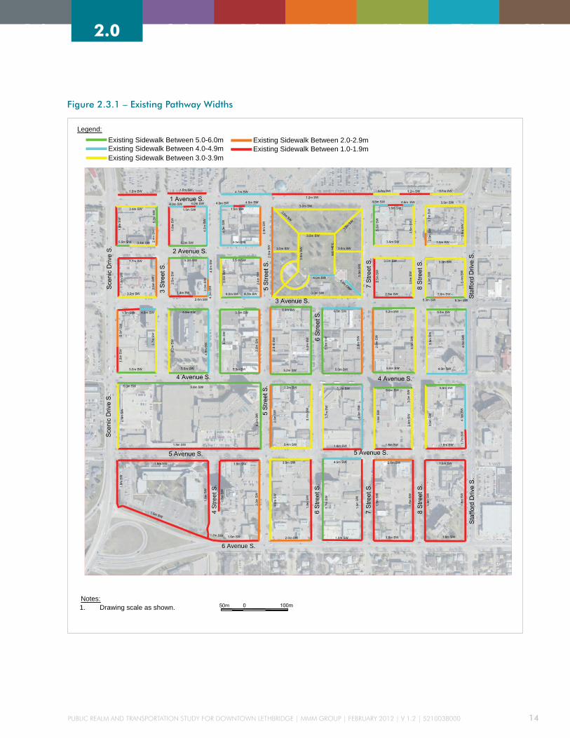
Public Realm and TRansPoRTaTion sTudy foR downTown leThbRidge | mmm gRouP | febRuaRy 2012 | v 1.2 | 5210038000 14
2.0 3.0 4.0 5.0 6.0 7.0 8.01.0 3.0 4.0 5.0 6.0 7.0 8.01.0 2.0
Figure 2.3.1 – Existing Pathway Widths
4 S
treet
S.
6 Avenue S.
Legend:
Public Realm & Transportation Studyfor Downtown Lethbridge
City of Lethbridge
MMM Ref 5210038000
Existing Pathway Conditions
1. Drawing scale as shown.
November 2011Drawing No. MMM-AT-001
Notes:
Existing Sidewalk Between 4.0-4.9mExisting Sidewalk Between 5.0-6.0m
Existing Sidewalk Between 3.0-3.9m
Existing Sidewalk Between 2.0-2.9mExisting Sidewalk Between 1.0-1.9m

Public Realm and TRansPoRTaTion sTudy foR downTown leThbRidge | mmm gRouP | febRuaRy 2012 | v 1.2 | 5210038000 15
2.0 3.0 4.0 5.0 6.0 7.0 8.01.0 2.0 3.0 4.0 5.0 6.0 7.0 8.01.0
2.3.2 ExISTING CYCLIST FACILITIES
MMM conducted a review of existing bicycle facility
conditions, related utilization, and pedestrian count, at
selected intersections, during a period of fine weather
in April 2011. The majority of the existing pathways
in the City’s Downtown core are for pedestrian use
only. There is an absence of designated bike lanes and
pathways for cyclists to facilitate connectivity within
the Downtown district.
Within the study area, 3 Avenue S has been designated
as a bike route; however, it does not have a marked
bike only lane.
The outside travelling lane width, along 3 Ave S, is just
3.4m; this is insufficient for a motorist to safely pass a
cyclist while remaining in the same lane. The existing
on-street parking also increases the potential for
conflict between then cyclist and the motorist; further
discouraging cycling along the corridor.
{{
The remainder of the streets
in the study area have various
travel lane widths that the
cyclist shares with vehicles.
There is general absence
of any cycle pavement
markings, wayfinding signing
or prioritisation for cycles.
Although cycling activity tends to increase during
fine weather it is unlikely to become a significant
proportion of overall traffic volume. This is due, in
part, to a lack of cycle infrastructure within the City,
but also because of the topography, urban spread, and
local climate. Frequent cyclists and commuters will
generally cycle on the most direct route, regardless
of the lack of cycling infrastructure. Recreational or
nervous cyclists do, however, tend to plan their routes
according to their level of comfort and the perceived
level of risk. Recreational cyclists are therefore those
most likely to make use of any new cycle lanes and
priority systems.
Despite the presence of bicycle racks within the Downtown area (Figure 2.3.2), it is not unusual to see cycles
locked to trees, signposts, railings, and other street furniture. This suggests the number of bike racks provided
is insufficient or not located where demand is greatest. Additionally, in locations where bicycle racks are
overloaded, a bicycle rack with higher capacity that allows bicycles to be parked upright should be considered.
» Bicycle locked to a parking meter in Downtown Lethbridge.
» Bicycle rack overloaded at 2 Avenue S and 5 Street S.
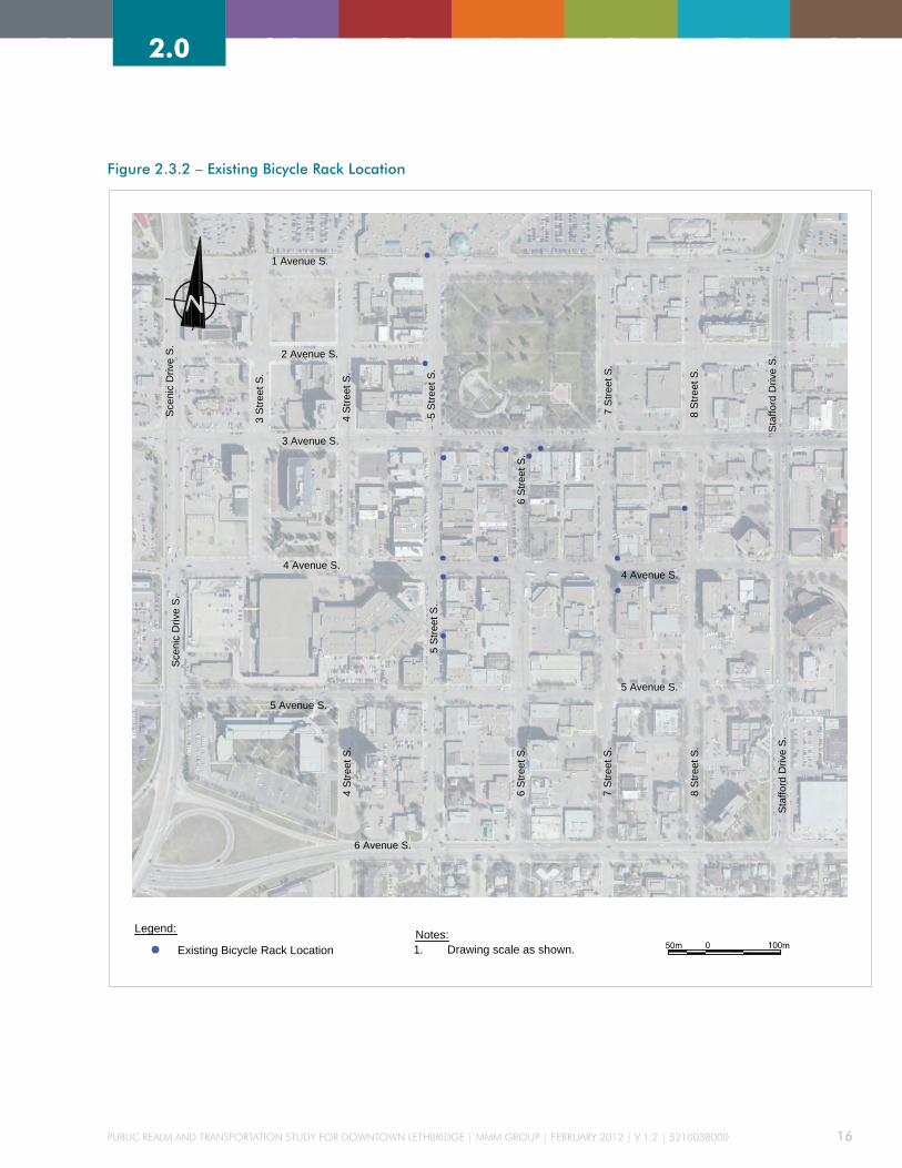
Public Realm and TRansPoRTaTion sTudy foR downTown leThbRidge | mmm gRouP | febRuaRy 2012 | v 1.2 | 5210038000 16
2.0 3.0 4.0 5.0 6.0 7.0 8.01.0 2.0 3.0 4.0 5.0 6.0 7.0 8.01.0
Figure 2.3.2 – Existing Bicycle Rack Location
1 Avenue S.
Sce
nic
Driv
e S
.S
ceni
c D
rive
S.
4 S
treet
S.
4 S
treet
S.
5 S
treet
S.
6 Avenue S.
8 S
treet
S.
4 Avenue S.
3 S
treet
S.
5 Avenue S.
3 Avenue S.
5 Avenue S.8
Stre
et S
.
7 S
treet
S.
7 S
treet
S.
2 Avenue S.
6 S
treet
S.
5 S
treet
S.
6 S
treet
S.
4 Avenue S.
Sta
fford
Driv
e S
.S
taffo
rd D
rive
S.
Legend:
Public Realm & Transportation Studyfor Downtown Lethbridge
City of Lethbridge
MMM Ref 5210038000
Bicycle Rack Locations
1. Drawing scale as shown.
November 2011Drawing No. MMM-1012-R0
Notes:
Existing Bicycle Rack Location
1 Avenue S.
Sce
nic
Driv
e S
.S
ceni
c D
rive
S.
4 S
treet
S.
4 S
treet
S.
5 S
treet
S.
6 Avenue S.
8 S
treet
S.
4 Avenue S.3
Stre
et S
.
5 Avenue S.
3 Avenue S.
5 Avenue S.
8 S
treet
S.
7 S
treet
S.
7 S
treet
S.
2 Avenue S.
6 S
treet
S.
5 S
treet
S.
6 S
treet
S.
4 Avenue S.
Sta
fford
Driv
e S
.S
taffo
rd D
rive
S.
Legend:
Public Realm & Transportation Studyfor Downtown Lethbridge
City of Lethbridge
MMM Ref 5210038000
Bicycle Rack Locations
1. Drawing scale as shown.
November 2011Drawing No. MMM-1012-R0
Notes:
Existing Bicycle Rack Location
1 Avenue S.
Sce
nic
Driv
e S
.S
ceni
c D
rive
S.
4 S
treet
S.
4 S
treet
S.
5 S
treet
S.
6 Avenue S.
8 S
treet
S.
4 Avenue S.
3 S
treet
S.
5 Avenue S.
3 Avenue S.
5 Avenue S.
8 S
treet
S.
7 S
treet
S.
7 S
treet
S.
2 Avenue S.
6 S
treet
S.
5 S
treet
S.
6 S
treet
S.
4 Avenue S.
Sta
fford
Driv
e S
.S
taffo
rd D
rive
S.
Legend:
Public Realm & Transportation Studyfor Downtown Lethbridge
City of Lethbridge
MMM Ref 5210038000
Bicycle Rack Locations
1. Drawing scale as shown.
November 2011Drawing No. MMM-1012-R0
Notes:
Existing Bicycle Rack Location

Public Realm and TRansPoRTaTion sTudy foR downTown leThbRidge | mmm gRouP | febRuaRy 2012 | v 1.2 | 5210038000 17
2.0 3.0 4.0 5.0 6.0 7.0 8.01.0 2.0 3.0 4.0 5.0 6.0 7.0 8.01.0
2.3.3 ExISTING PEDESTRIAN AND CYCLIST SURVEY
A count of pedestrians and cyclists was conducted by MMM on a warm sunny day in April 2011. The count
locations were conducted within the selected priority streets. The locations of the survey with the peak pedestrian
and cyclist volume are shown in Figure 2.3.2 (See Technical Reports Appendix E for pedestrian and cyclists
counts).
Figure 2.3.3 – Peak Hour Pedestrian and Cyclist Survey

Public Realm and TRansPoRTaTion sTudy foR downTown leThbRidge | mmm gRouP | febRuaRy 2012 | v 1.2 | 5210038000 18
2.0 3.0 4.0 5.0 6.0 7.0 8.01.0 3.0 4.0 5.0 6.0 7.0 8.01.0 2.0
The result of the survey demonstrates that there is considerable
pedestrian activity within the Downtown core and along the priority
streets during day. The highest pedestrian movement occurs around
mid-day (noon to 1pm) corresponding with the trips for food,
shopping, and general errand trips. This also correlates with the
existing parking survey information that shows the peak period for
parking occurs around lunchtime.
There was an unexpected low level of pedestrian activity along 2
Avenue S at Scenic Drive S. Higher pedestrian activity was expected
because of the large housing complex west of Scenic Drive S and its
proximity to Galt Gardens and the Downtown core. Improvements
could easily be made to the intersection of 2 Avenue & Scenic Drive
to increase the attractiveness, and overall sense of safety, at the high
volume intersection. The current lack of amenities and services on 2
Avenue S may also contribute to lower than expected pedestrian usage
along this corridor. As the block becomes more developed it is hoped
that this pedestrian connection will become a stronger corridor.
There is significant pedestrian activity along 5 Street S and 4 Avenue
S during the mid-day as employees in the Downtown district head
out for lunch to the local restaurants or complete a quick errand at
the local shops. Galt Gardens is a major attractor during the mid-day
as people eat in park, take a brisk walk, or relax within the attractive
surroundings.
Cyclist activity observed was evenly distributed throughout priority
streets in the Downtown area. There does not appear to be a distinct
preferred bike corridor; a wider count may reveal better trends and
travel patterns although the overall level of cycle activity is unlikely
to increase significantly unless better bike connections are made in
the Downtown area. Improvements to cycle priority systems, and
better connectivity with the trails and pathways system, will help
increase the number of cyclists although these will probably be
recreational users rather than commuters. To increase the proportion
of commuters the City may wish to consider sponsoring a training or
cycle education session that will increase the confidence level of those
considering cycling more.

Public Realm and TRansPoRTaTion sTudy foR downTown leThbRidge | mmm gRouP | febRuaRy 2012 | v 1.2 | 5210038000 19
2.0 3.0 4.0 5.0 6.0 7.0 8.01.0 2.0 3.0 4.0 5.0 6.0 7.0 8.01.0
2.4 ROAD GEOMETRY
2.4.1 ExISTING ROADWAY CLASSIFICATION AND CROSS-SECTIONS
Roadway classifications for the three selected
roadways are provided in Table 2.4.1 with existing
cross-sections shown in Figure 2.4.1. The roadways are
2 Avenue S from Scenic Drive S to 5 Street S; 3 Avenue
S from 4 Street S to 8 Street S; and, 5 Street S from
1 Avenue S to 6 Avenue S. The estimated pavement
width was determined using GIS information provided
by the City.
Some common design elements of the three roadways
are:
» 30.5m R.O.W. width
» 50km/h speed limit – not posted
» 60km/h design speed
» 3.5m lanes on 2-lane roadways
» 3.4-3.2m lanes on 4-lane roadways
» 2.5-2.6m parallel parking lanes
» 5.4m stall length (perpendicular) for 450 angle
parking
» 5.8m stall length (perpendicular) for 600 angle
parking
Table 2.4.1 – Existing Roadway Conditions
Roadway: SectionService
ClassificationNumber of Lanes
Finished Pavement Width (m)
Typical Intersection Spacing –
Property Lines (m) Parking
2 avenue s: scenic drive s to 5 street s
local Road 2 18.5 84 60° angle (north/south)
3 avenue s: 4 street s to 8 street s
arterial Road 4 18.6 84 Parallel (north/south)
5 street s: 1 avenue s to 3 avenue s
collector Road 4 23.7 137 45°angle east 60° angle west
5 street s: 3 avenue s to 4 avenue s
collector Road 4 23.7 137 45°angle (east/west)
5 street s: 4 avenue s to 6 avenue s
collector Road 4 21.2 84-137 45° angle (east), Parallel (west)
The city’s design standard for a typical collector road is 3.5m wide lanes; for lanes adjacent to parallel parking (2.4m) the travel lane width is 3.1m.
The Tac geometric design guide recommends a minimum lane width, on collector roads, of 3.5-3.7m on new construction, and 3.3-3.5m on existing infrastructure. whilst these lanes are permitted it should be noted that a motorist passing a cyclist will probably have to move into the adjacent travel lane.
The angled parking perpendicular stall length includes a curb overhang and is within accepted parking standards. The parallel parking width is consistent within the city and Tac standards.

Figure 2.4.1 – Typical Cross Sections
2.0 3.0 4.0 5.0 6.0 7.0 8.01.0

Public Realm and TRansPoRTaTion sTudy foR downTown leThbRidge | mmm gRouP | febRuaRy 2012 | v 1.2 | 5210038000 21
2.0 3.0 4.0 5.0 6.0 7.0 8.01.0 2.0 3.0 4.0 5.0 6.0 7.0 8.01.0
2.4.2 ExISTING INTERSECTIONS
The most common roadway in the Downtown core is a four-lane road with some minor two-lane roads. The
majority of the intersections are signalized and, with the exception of those on Scenic Drive and Stafford Drive, do
not have separate left-turn or right-turn lanes. However, within the Downtown core, the typical intersection has a
shared through-left turn lane and a shared through-right turn lane. There are currently twelve intersections along
the selected streets; Figure 2.4.2 illustrates the intersection control type for each.
Figure 2.4.2 – Intersection Types on Selected Streets

Public Realm and TRansPoRTaTion sTudy foR downTown leThbRidge | mmm gRouP | febRuaRy 2012 | v 1.2 | 5210038000 22
2.0 3.0 4.0 5.0 6.0 7.0 8.01.0 2.0 3.0 4.0 5.0 6.0 7.0 8.01.0
A summary of the intersection analysis provided for
the intersections provided in Section 2.5.
The existing turning 9.0m radii at the intersections
are suitable to accommodate turning movements
for emergency and commercial freight vehicles that
need to access businesses. There are no existing curb
extensions at the intersections and typical pavement
markings for crosswalks are parallel lines.
2.4.3 ExISTING TRAFFIC VOLUMES
MMM completed an extensive traffic count program
to determine the existing traffic volumes within the
study area. MMM used video survey equipment to
determine the pedestrian count, vehicle type, and
turning movements at the intersections. The traffic
program consisted of counts taken at fifteen locations
in November 2010 and a further five counts in April
2011. The City also provided some additional traffic
at other locations (see Figure 2.4.3.1 for locations and
survey count periods).
A detailed capacity analysis was conducted at the
eight major intersections as shown in Figure 2.4.3.2.
The observed traffic volumes were calibrated and the
operational performance of each intersection was
analyzed. The determination of the morning peak hour
volumes was accomplished by utilizing the observed
traffic data. When there was a notable discrepancy
between the MMM counts and those collected by the
City, then it was agreed that the higher volume would
prevail.
» Scenic Drive S and 2 Avenue S – volumes on
Scenic Drive S were determined from the traffic
counts at Scenic Drive S – 1 Avenue S intersection
and Scenic Drive S – 3 Avenue S intersection.
The volumes for 2 Avenue S were determined by
reviewing the eastbound and westbound intersection
volumes at Scenic Drive with 1 Avenue S through 5
Avenue S in combination with a general comparison
of the existing land use along 2 Avenue S with the
land use along 1 Avenue S through 5 Avenue S.
» 5 Street S and 1 Avenue S – peak volumes at this
intersection were determined using the traffic counts
from Scenic Drive S – 1 Avenue S and Stafford
Drive S – 1 Avenue S. Consideration was given for
Park Place Mall as it is a significant destination and
generator of traffic.
» 5 Street S and 2 Avenue S – volumes were
determined using the traffic count volumes for 5
Street S – 3 Avenue S and the estimated volumes at 5
Street S – 1 Avenue S .
» 5 Street S and 5 Avenue S – volumes at this
intersection were determined using the traffic
counts from 5 Street S – 6 Avenue S intersection.
Consideration was given for the large parking
structure at Lethbridge Centre that is a significant
destination and generator of traffic. The number of
eastbound traffic along 6 Avenue that is destined
for the Lethbridge Centre would avoid the exit at
Scenic Drive S to avoid the high traffic volumes, this
would help account for the high number of left turn
movements from 6 Avenue S onto 5 Street S. Review
of the morning volumes northbound from 5 Street
S – 6 Avenue S intersection is approximately 375
vehicles and is reduced to 170 vehicles by the time
the traffic reaches 5 Street S – 5 Avenue S.

Public Realm and TRansPoRTaTion sTudy foR downTown leThbRidge | mmm gRouP | febRuaRy 2012 | v 1.2 | 5210038000 23
2.0 3.0 4.0 5.0 6.0 7.0 8.01.0 2.0 3.0 4.0 5.0 6.0 7.0 8.01.0
Figure 2.4.3.1 – Traffic Count Locations

Public Realm and TRansPoRTaTion sTudy foR downTown leThbRidge | mmm gRouP | febRuaRy 2012 | v 1.2 | 5210038000 24
2.0 3.0 4.0 5.0 6.0 7.0 8.01.0 2.0 3.0 4.0 5.0 6.0 7.0 8.01.0
Figure 2.4.3.2 – Existing Traffic Volumes and Operations Diagram
The Existing Traffic Volume and Analysis Report are provided in Technical Report Appendix E. The following 2.4.3.2 –
Existing Traffic Volumes and Operations Diagram summarize the 2010 AM and PM peak traffic volumes:

Public Realm and TRansPoRTaTion sTudy foR downTown leThbRidge | mmm gRouP | febRuaRy 2012 | v 1.2 | 5210038000 25
2.0 3.0 4.0 5.0 6.0 7.0 8.01.0 2.0 3.0 4.0 5.0 6.0 7.0 8.01.0
2.5 2010 INTERSECTION CAPACITY ANALYSIS
The intersection traffic analysis is based on the Highway Capacity Manual
(HCM), Measures of Effectives (MOE). The standard MOE are defined as
average control delay in seconds, maximum volume to capacity ratio for a
traffic movement, and the LOS. The HCM identifies six different levels of
service from “A” to “F”, as follows in Table 2.5.1.
The resulting level of service from the traffic analysis for the intersection was
included in Figure 2.4.3.2. A summary of the detailed results are in table 2.5 for
the 2010 AM and PM peak hours traffic analysis. Measurements are based upon
the AM and PM peak traffic numbers determined in Section 2.4.3.
The results of peak hour 2010 traffic is that the flow of traffic at the
intersections are practically unaffected by the presence of other vehicles on
a road sections operating at a LOS A or B. These results suggest that there is
significant additional capacity at these intersections. The detailed Synchro AM
and PM peak hour traffic analysis report can be found in the Technical Reports
Appendix E.
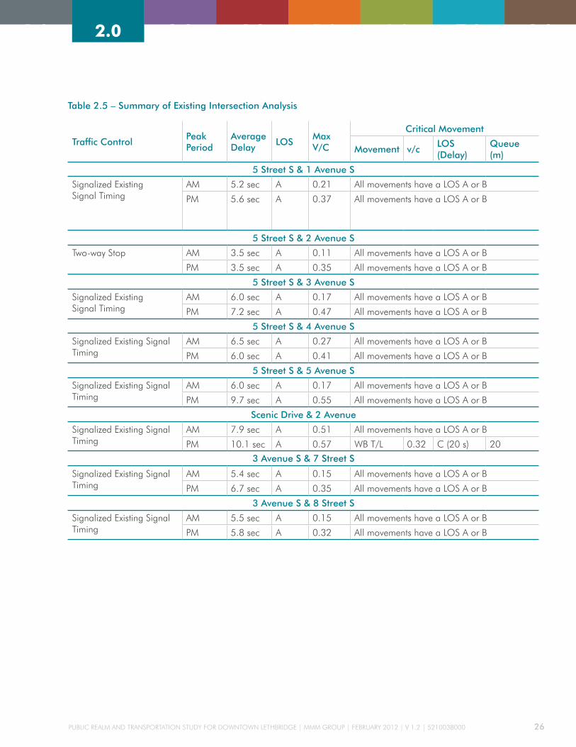
Public Realm and TRansPoRTaTion sTudy foR downTown leThbRidge | mmm gRouP | febRuaRy 2012 | v 1.2 | 5210038000 26
2.0 3.0 4.0 5.0 6.0 7.0 8.01.0 2.0 3.0 4.0 5.0 6.0 7.0 8.01.0
Table 2.5 – Summary of Existing Intersection Analysis
Traffic ControlPeak Period
Average Delay
LOSMax V/C
Critical Movement
Movement v/cLOS (Delay)
Queue (m)
5 Street S & 1 Avenue S
signalized existing signal Timing
am 5.2 sec a 0.21 all movements have a los a or b
Pm 5.6 sec a 0.37 all movements have a los a or b
5 Street S & 2 Avenue S
Two-way stop am 3.5 sec a 0.11 all movements have a los a or b
Pm 3.5 sec a 0.35 all movements have a los a or b
5 Street S & 3 Avenue S
signalized existing signal Timing
am 6.0 sec a 0.17 all movements have a los a or b
Pm 7.2 sec a 0.47 all movements have a los a or b
5 Street S & 4 Avenue S
signalized existing signal Timing
am 6.5 sec a 0.27 all movements have a los a or b
Pm 6.0 sec a 0.41 all movements have a los a or b
5 Street S & 5 Avenue S
signalized existing signal Timing
am 6.0 sec a 0.17 all movements have a los a or b
Pm 9.7 sec a 0.55 all movements have a los a or b
Scenic Drive & 2 Avenue
signalized existing signal Timing
am 7.9 sec a 0.51 all movements have a los a or b
Pm 10.1 sec a 0.57 wb T/l 0.32 c (20 s) 20
3 Avenue S & 7 Street S
signalized existing signal Timing
am 5.4 sec a 0.15 all movements have a los a or b
Pm 6.7 sec a 0.35 all movements have a los a or b
3 Avenue S & 8 Street S
signalized existing signal Timing
am 5.5 sec a 0.15 all movements have a los a or b
Pm 5.8 sec a 0.32 all movements have a los a or b

Public Realm and TRansPoRTaTion sTudy foR downTown leThbRidge | mmm gRouP | febRuaRy 2012 | v 1.2 | 5210038000 27
2.0 3.0 4.0 5.0 6.0 7.0 8.01.0 2.0 3.0 4.0 5.0 6.0 7.0 8.01.0
Table 2.5.1 – Traffic Analysis Level of Service Description
Level of Service Description
Signalized Inter-section (Average delay per vehicle)
Unsignalized Inter-section (Average delay per vehicle)
A – Free Flow Traffic
Primarily free-flow operations at average travel speeds, usually about 90 percent of the free flow speed (ffs) for the given street class. vehicles are completely unimpeded in their ability to manoeuvre within the traffic stream.
≤10 sec ≤10 sec
B – Steady Flow Reasonably unimpeded operations at average travel speeds, usually about 70 percent of the ffs for the street class. The ability to manoeuvre within the traf-fic stream is only slightly restricted.
10-20 sec 10-15 sec
C – Steady Traf-fic But Limited
stable operations; however, ability to manoeuvre and change lanes in midblock locations may be more restricted than at los b, and longer queues adverse signal coordination, or both may contribute to lower average travel speeds of about 50 percent of the ffs for the street class
20-35 sec 15-25 sec
D – Steady Traffic at High Density
borders on a range in which small increases in flow may cause substantial increases in delay and decreases in travel speed. los d may be due to adverse signal progression, inappropriate signal timing, high volumes, or a combination of these factors. average travel speeds are about 40 percent of ffs
35-55 sec 25-35 sec
E – Traffic at Saturation
characterized by significant delays and average travel speeds of 33 percent or less of the ffs. such operations are caused by a combination of adverse progression, high signal density, high volumes, extensive delays at critical intersections, and inap-propriate signal timing.
55-80 sec 35-50 sec
F – Congestion characterized by urban street flow at extremely low speeds, typically one third to one fourth of the ffs. intersection congestion is likely at critical signal-ized locations, with high delays, high volumes, and extensive queuing.
≥80 sec ≥50 sec

Public Realm and TRansPoRTaTion sTudy foR downTown leThbRidge | mmm gRouP | febRuaRy 2012 | v 1.2 | 5210038000 28
2.0 3.0 4.0 5.0 6.0 7.0 8.01.0 2.0 3.0 4.0 5.0 6.0 7.0 8.01.0
2.6 ExISTING TRANSIT REVIEW
The Downtown study area is currently served by five
transit routes with some variations depending on the
served areas out of Downtown. The following routes
serve the study area:
a) route 12 to University, Columbia Blvd, and College
b) route 14 to University and North Terminal
c) route 20 north schedule to Winston Churchill
d) route 20 south schedule to Lakeview
e) route 21 north schedule to Nord-Bridge
f) route 21 south schedule to Henderson Lake
g) route 22 north schedule to Park Meadows
(Rehabilitation Society)
h) route 22 south schedule to Agnes Davidson
Table 2.6.1 summarizes the typical headways during
peak and off-peak periods for the different routes
serving the Downtown area.
Table 2.6.1 – Transit Headways at City Centre (Source: City Fall Transit Schedule, 2011)
Bus Number Period
Approx. Headway Weekdays
Approx. Headway Saturdays
Approx. Headway Sundays Comments
12
Peak Periods 15 min 30 min 60 min from may to august some buses don’t run during peak hours resulting in headways of approximately 30 min
off-Peak Periods 30 min 60 min (last bus) 60 min 60 min
operation 6:00 am to 11:58 pm 7:00 am to 11:58 pm 8:58 am to 6:02 pm
14
Peak Periods 30 min - -
express routeoff-Peak Periods 30 min - -
operation 6:45 am to 6:45 pm - -
20 North and South
Peak Periods 30 min 30 min 60 min
-off-Peak Periods 30 min 60 min (last bus) 30-60 min 60 min
operation 6:00 am to 11:58 pm 7:00 am to 11:58 pm 8:58 am to 6:02 pm
21 North
Peak Periods 30 min 30 min 60 min
-off-Peak Periods 30 min 60 min (last bus) 30 – 60 min 60 min
operation 6:00 am to 11:30 pm 7:30 am to 11:30 pm 8:32 am to 6:32 pm
21 South
Peak Periods 30 min 30 min 60 min
-off-Peak Periods 30 min 60 min (last bus) 30 – 60 min 60 min
operation 6:00 am to 11:30 pm 7:00 am to 11:30 pm 8:02 am to 6:02 pm
22 North
Peak Periods 30 min 30 min 60 min
-off-Peak Periods
30 min 60 min (last bus)
30 – 60 min 60 min
operation 6:00 am to 11:00 pm7:00 am to 11:00 pm
8:02 am to 6:02 pm
22 South
Peak Periods 30 min 30 min 60 min
-off-Peak Periods 30 min 60 min (last bus) 30 – 60 min 60 min
operation 6:00 am to 11:54 pm 7:00 am to 11:54 pm 8:02 am to 6:02 pm

Public Realm and TRansPoRTaTion sTudy foR downTown leThbRidge | mmm gRouP | febRuaRy 2012 | v 1.2 | 5210038000 29
2.0 3.0 4.0 5.0 6.0 7.0 8.01.0 2.0 3.0 4.0 5.0 6.0 7.0 8.01.0
Figure 2.6.1 shows the various transit routes and bus stop locations on an aerial photograph of the Downtown area.
MMM collected passenger boarding and alighting data at four locations identified with City staff. The data was
recorded in 12-hour of video surveys between 7am and 7pm at each location on Tuesday, December 7, 2010.
Additional data was collected manually during the peak periods at bus stop # 14013 (at 4 Avenue S east of 3 Street
S serving the EB direction of traffic). Figure 2.6.2 illustrates the transit survey locations. Table 2.6.2 summarizes
the boarding and alighting passenger survey for the 12-hour period by site location.
Figure 2.6.1 – Transit Infrastructure and Routes (Source: City, 2011)1 Avenue S.
Sce
nic
Driv
e S
.
4 S
treet
S.
4 S
treet
S.
5 S
treet
S.
6 Avenue S.
8 S
treet
S.
4 Avenue S.
3 S
treet
S.
5 Avenue S.
3 Avenue S.
5 Avenue S.
8 S
treet
S.
7 S
treet
S.
7 S
treet
S.
2 Avenue S.
6 S
treet
S.
5 S
treet
S.
6 S
treet
S.
4 Avenue S.
Sta
fford
Driv
e S
.S
taffo
rd D
rive
S.
#14019
#14018
#14020
#14017
#14013
#14002
#14007#14008
#14006
#14005#14003
#14009
#12218
#12300
#12219
#14010
#14025
#14024
#14026
#14014
#14021
#14011
#14021*
#14022
#12178
#504
#14004
#14023
#14012
Notes:
Legend:
Public Realm and Transportation Study for Downtown Lethbridge
City of Lethbridge
Transit Infrastructure and Routes
MMM Ref. 5210038000Drawing No. MMM-1007-R0
November 2011
StopNumber
Bus RouteNumber(s)
504
12300
12039
12178
12218
12219
14002
14003
14004
14005
14006
14007
14008
14009
14010
14011
14012
14013
14014
14017
14018
14019
14020
14021
14021*
14022
14023
14024
14025
14026
21
21
20, 21
22
22
22
14
20
20
20
20
20
20
22
20, 22
20, 21
20
12, 14, 20, 22
12, 14
12
12
14
12, 14, 22
14, 20, 21, 22
14, 21
12, 14, 21
20, 21, 22
20
21
21
Transit Stop Location
Bus Shelter Location
Transit Route 20
Transit Route 22
Transit Route 12
Transit Route 21
Transit Route 14
Transit Stop Number#00000
1. Drawing scale as shown
1 Avenue S.
Sce
nic
Driv
e S
.
4 S
treet
S.
4 S
treet
S.
5 S
treet
S.
6 Avenue S.
8 S
treet
S.
4 Avenue S.
3 S
treet
S.
5 Avenue S.
3 Avenue S.
5 Avenue S.
8 S
treet
S.
7 S
treet
S.
7 S
treet
S.
2 Avenue S.
6 S
treet
S.
5 S
treet
S.
6 S
treet
S.
4 Avenue S.
Sta
fford
Driv
e S
.S
taffo
rd D
rive
S.
#14019
#14018
#14020
#14017
#14013
#14002
#14007#14008
#14006
#14005#14003
#14009
#12218
#12300
#12219
#14010
#14025
#14024
#14026
#14014
#14021
#14011
#14021*
#14022
#12178
#504
#14004
#14023
#14012
Notes:
Legend:
Public Realm and Transportation Study for Downtown Lethbridge
City of Lethbridge
Transit Infrastructure and Routes
MMM Ref. 5210038000Drawing No. MMM-1007-R0
November 2011
StopNumber
Bus RouteNumber(s)
504
12300
12039
12178
12218
12219
14002
14003
14004
14005
14006
14007
14008
14009
14010
14011
14012
14013
14014
14017
14018
14019
14020
14021
14021*
14022
14023
14024
14025
14026
21
21
20, 21
22
22
22
14
20
20
20
20
20
20
22
20, 22
20, 21
20
12, 14, 20, 22
12, 14
12
12
14
12, 14, 22
14, 20, 21, 22
14, 21
12, 14, 21
20, 21, 22
20
21
21
Transit Stop Location
Bus Shelter Location
Transit Route 20
Transit Route 22
Transit Route 12
Transit Route 21
Transit Route 14
Transit Stop Number#00000
1. Drawing scale as shown

Public Realm and TRansPoRTaTion sTudy foR downTown leThbRidge | mmm gRouP | febRuaRy 2012 | v 1.2 | 5210038000 30
2.0 3.0 4.0 5.0 6.0 7.0 8.01.0 2.0 3.0 4.0 5.0 6.0 7.0 8.01.0
Figure 2.6.2 – Transit Survey Site Location

Public Realm and TRansPoRTaTion sTudy foR downTown leThbRidge | mmm gRouP | febRuaRy 2012 | v 1.2 | 5210038000 31
2.0 3.0 4.0 5.0 6.0 7.0 8.01.0 2.0 3.0 4.0 5.0 6.0 7.0 8.01.0
Site LocationBus Stop Number
Count Description Period
Boarding Passenger
Alighting Passenger
Site 1wb direction at 4 avenue s between 7 street s and 6 street s
#14011 (two spots)
east spot
9.50 hours 119 173
2 hour am peak 13 41
2 hour Pm peak 52 45
Site 2eb direction at 4 avenue s between 6 street s and 7 street s
#14021 (two of four spots)
east spot
12 hour 121 295
2 hour am peak 28 79
2 hour Pm peak 32 52
Site 2 west spot
12 hour 123 206
2 hour am peak 33 30
2 hour Pm peak 25 62
Site 3
eb direction at 4 avenue s between 6 street s and 7 street s
#14021 (two of four spots)
east spot
12 hour 187 138
2 hour am peak 27 32
2 hour Pm peak 36 22
Site 3 west spot
12 hour 211 159
2 hour am peak 24 28
2 hour Pm peak 50 33
Site 4eb direction at 4 avenue s between 5 street s and 6 street s
#14014 (two spots)
east spot
12 hour 419 222
2 hour am peak 49 59
2 hour Pm peak 104 55
Site 5
eb direction at 4 avenue s between 3 street s and 4 street s
#14013 (two spots)
Two spots
6 hour 2 41
2 hour am peak 0 10
2 hour Pm peak 1 17
Transit bus stops, sites one through four form part of the existing central bus stop in the heart of Downtown.
No further analysis or transit data collection was undertaken by MMM as the City of Lethbridge advised that a
detailed transit analysis was not required. Additional transit information, including transit data collection, is
provided in the Technical Reports Appendix F.
Table 2.6.2 – Boarding and Alighting Passenger Transit Survey Summary

Public Realm and TRansPoRTaTion sTudy foR downTown leThbRidge | mmm gRouP | febRuaRy 2012 | v 1.2 | 5210038000 32
2.0 3.0 4.0 5.0 6.0 7.0 8.01.0 2.0 3.0 4.0 5.0 6.0 7.0 8.01.0
2.7 ExISTING PARKING CONDITIONS
2.7.1 ExISTING PARKING SUPPLY
Based on detailed parking inventories completed in
late 2010 and early 2011, there are approximately
5,418 non-residential parking stalls within the study
area. Of these spaces, approximately 1,827 spaces are
public on-street, 440 are public off-street, and 3,151
are private off-street parking locations. Most of the
on-street parking is available for short-term parking
periods, with time limits of less than 3 hours. Long-
term parking, of up to 10-hour duration, is available in
other meter locations. Typical rates are $0.80 per hour
(short term), and $0.35 per hour (10-hour long term
parking). Free parking spaces are available, however
these are mostly found at the edge of and beyond the
Downtown study area.
2.7.2 ExISTING PARKING DEMANDS
MMM conducted a series of comprehensive parking
utilization surveys in late 2010 and early 2011.
Analysis suggests that that the overall parking demand
is relatively stable throughout the day, with peak
parking demand occurring just before midday. The
peak parking utilization is approximately 59% across
the Downtown. This suggests that there is considerable
residual parking capacity available in the Downtown as
a whole during most times of the day.
Parking utilization was also assessed on the basis of
individual blocks and block faces. Off-street parking on
the following blocks was found to be highly utilized:
» 4 Street S/1 Avenue S/5 Street S/2 Avenue S
» 5 Street S/4 Avenue S/6 Street S/5 Avenue S
» Scenic Drive/5 Avenue S/4 Street S/6 Avenue S
» 4 Street S/5 Avenue S/5 Street S/6 Avenue S
» 5 Street S/5 Avenue S/6 Street S/6 Avenue S
» 8 Street S/5 Avenue S/Stratford Drive/6 Avenue S
On-street parking is also being highly utilized at many
locations throughout the Downtown, including some
parts of the priority areas along 2 Avenue S, 3 Avenue
S, and 5 Street S.
The overall parking demand rate was measured to be
2.10 to 2.22 spaces per 100 m2 (1 space per 45 m2 to
48 m2). This is consistent with the City of Lethbridge
Land Use Bylaw minimum parking requirements for
medical and general office use, and lower than those
for restaurant and retail uses. This also falls within
the range of parking demand rates observed in other
Downtown areas.
(See Technical Report Appendix G for the complete
Lethbridge Downtown Parking – Existing and Short
Term Future Parking Conditions Report)

Public Realm and TRansPoRTaTion sTudy foR downTown leThbRidge | mmm gRouP | febRuaRy 2012 | v 1.2 | 5210038000 33
2.0 3.0 4.0 5.0 6.0 7.0 8.01.0 2.0 3.0 4.0 5.0 6.0 7.0 8.01.0
2.8 FREIGHT REVIEW
According to the 2010 City’s Dangerous Goods and
Truck Route Map, there is no dangerous goods
route within the study area; however, Scenic Drive
S is designated as a Truck Route. In addition, the
truck activity within the Downtown core area and
surroundings could be affected by any changes
introduced to the transportation system, in terms of
the operation, level of service, proper accommodation
and safety.
During the 12-hour traffic survey and counts the
number of heavy trucks were recorded. MMM then
compared their results with those provided by the
City of Lethbridge. The following Figure 2.8.1 shows
the percentage of heavy vehicles, including the City’s
transit buses, observed during the AM and PM peak
hour period. The results show that there are relatively
few large vehicles trying to access the Downtown area
during the peak periods. Furthermore, MMM’s own
12hr video surveillance suggested that heavy truck
movements within the Downtown area are very low
during off-peak periods as well.
Where the results show a high proportion of heavy
vehicles, eg. 22.6% heavy vehicle movement was
observed on the north approach of 6 Street S at 6
Avenue S, it is understood that this is a consequence
of having low background traffic – only twenty-three
vehicles were observed during the peak period, five of
these were heavy vehicles turning right into 6 Ave S.
The percentage of heavy vehicles is also greater on
4 Avenue S even though most of the observed heavy
vehicles were transit buses.
In addition to the observed counts, MMM conducted
a freight survey which was forwarded to all members
of the Business Revitalization Zone and the Chamber
of Commerce. A sample copy of the freight survey is
included in Technical Reports Appendix K.
The purpose of the freight survey was to identify the
preferred routes for movement of goods and services
through the Downtown area, to quantify the types
and number of vehicles that were being used to move
goods, the principal time periods for goods movement,
and any problem areas experienced by carriers.
From a sample set of 274 stakeholders, only 19
completed surveys were returned. This low response
from the study area businesses does not provide a
statistically significant outcome; however, it does
provide an insight into the freight operations within
the study area, providing complementary information
to the truck data collected by observation counts.
Of the complete responses, seventeen were from
businesses located within the study area. The type of
goods delivered to the business varied including food,
beverages, household products, furniture, electronics/
appliances, apparel, jewellery, and home decoration.

Public Realm and TRansPoRTaTion sTudy foR downTown leThbRidge | mmm gRouP | febRuaRy 2012 | v 1.2 | 5210038000 34
2.0 3.0 4.0 5.0 6.0 7.0 8.01.0 2.0 3.0 4.0 5.0 6.0 7.0 8.01.0
Figure 2.8.1 – Peak Hour Heavy Vehicle Percentage

Public Realm and TRansPoRTaTion sTudy foR downTown leThbRidge | mmm gRouP | febRuaRy 2012 | v 1.2 | 5210038000 35
2.0 3.0 4.0 5.0 6.0 7.0 8.01.0 2.0 3.0 4.0 5.0 6.0 7.0 8.01.0
Figure 2.8.2 illustrates that in about 50% of the
responses, the delivery of goods is made by medium
size trucks (single unit truck), followed by small
vehicles (Cars, Mini-vans, SUVs or similar), and in
about 15% by single trailer trucks (single articulated
trucks).
Video observations suggest that freight movement,
by single trailer trucks and other large vehicles,
represents about 1% of the total traffic within the
Downtown core.
Figures 2.8.3 to 2.8.5 illustrate the delivery temporal
distribution. In half of the cases, the surveyed
businesses scheduled deliveries between 2 to 4 days
per week, about 30% less or one day per week, and
close to 20% five or more days per week. Of this, in
80% of the cases the delivery is made by 1 to 2 trucks
per day. In addition, most of the deliveries take place
during the daytime hours between 5 am to noon
(45%) and between noon to 5 pm (55%). No business
reported deliveries between the 10 pm to 5 am periods.
Notice that trucks includes all the delivery vehicle
types identified previously.
Figure 2.8.6 presents the preferred routes reported
in the survey responses. Due to the low number of
replies, no accurate conclusions can be drawn, thus
caution should be used when reviewing the data.
Respondents of the surveys (10 of 17) identified issues
regarding the use of back alleys to make deliveries. In
general, businesses reported they deliver or receive
goods through the back alleys, even though they are
often congested or blocked by parked cars or trucks,
and are not maintained (snow removal) during winter.
Figure 2.8.3 – Freight Weekly Delivery Distribution
Figure 2.8.2 – Motor Vehicle Type Frequency Distribution
Figure 2.8.4 – Freight Daily Delivery Distribution
Figure 2.8.5 – Freight Hourly Delivery Distribution
0
10
20
30
40
50
60
1 day/week or less 2 to 4 days/week 5 or more days/week
Weekly Delivery Distribution (Days per Week)
Delivery Frequency
Freq
uenc
y (%
)
0
10
20
30
40
50
60
Cars
, Min
i-Van
s, S
UVs
Med
ium
Size
Tru
ck
Sing
le T
raile
r Tru
ck
N.A
. / U
nkno
wn
Motor-Vehicle Type Frequency Distribution
Vehicle Type
Freq
uenc
y (%
)
0
5
10
15
20
25
30
35
5AM to 12PM 12PM to 5PM 5PM to 10PM 10PM to 5AM
Never Rarely Frequently
Hourly Delivery Distribution
Freq
uenc
y (%
)
0102030405060708090
100
None 1 to 2 3 to 5 6 to 10 Other
Daily Delivery Distribution (Trucks per Day)
Number of Trucks per Day
Freq
uenc
y (%
)
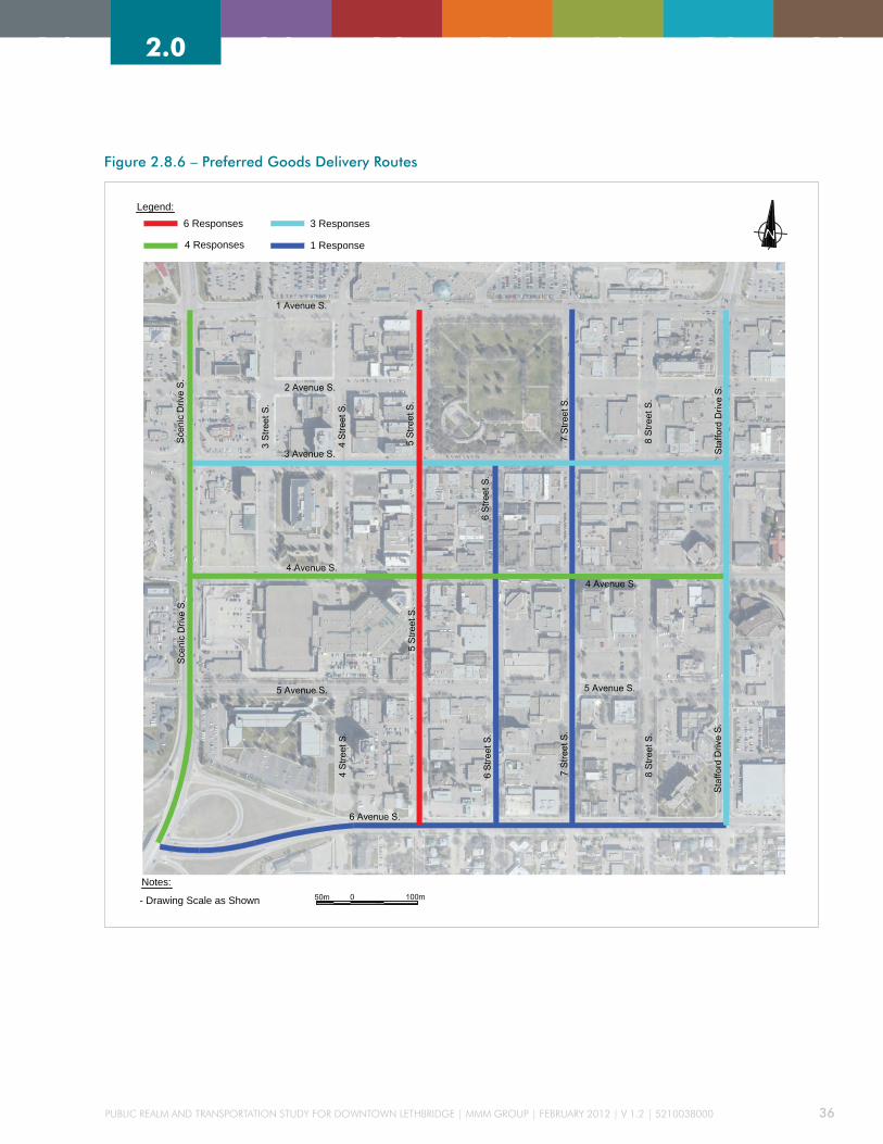
Public Realm and TRansPoRTaTion sTudy foR downTown leThbRidge | mmm gRouP | febRuaRy 2012 | v 1.2 | 5210038000 36
2.0 3.0 4.0 5.0 6.0 7.0 8.01.0 2.0 3.0 4.0 5.0 6.0 7.0 8.01.0
Figure 2.8.6 – Preferred Goods Delivery Routes
Notes:
Legend:
Public Realm & Transportation Studyfor Downtown Lethbridge
City of Lethbridge
MMM Ref 5210038000
Preferred Goods Delivery Routes
Drawing No. MMM-1051-R0November 2011
- Drawing Scale as Shown
6 Responses
4 Responses
3 Responses
1 Response
Notes:
Legend:
Public Realm & Transportation Studyfor Downtown Lethbridge
City of Lethbridge
MMM Ref 5210038000
Preferred Goods Delivery Routes
Drawing No. MMM-1051-R0November 2011
- Drawing Scale as Shown
6 Responses
4 Responses
3 Responses
1 Response

Public Realm and TRansPoRTaTion sTudy foR downTown leThbRidge | mmm gRouP | febRuaRy 2012 | v 1.2 | 5210038000 37
2.0 3.0 4.0 5.0 6.0 7.0 8.01.0 2.0 3.0 4.0 5.0 6.0 7.0 8.01.0
No major problems were identified regarding
loading and unloading freight operations within the
study area. However, the City should establish and
provide signage for loading/unloading zones in the
alleys for individual business. Providing that non-
articulated trucks are used for these purposes and that
commercial vehicles are not left unattended. Future
development should be designed in a manner that
takes adequate loading and unloading zones as well as
circulation and access into consideration.
The City should continue to monitor freight traffic
along the major routes to ensure the transportation
network continues to adequately accommodate freight
operations.

Public Realm and TRansPoRTaTion sTudy foR downTown leThbRidge | mmm gRouP | febRuaRy 2012 | v 1.2 | 5210038000 38
2.0 3.0 4.0 5.0 6.0 7.0 8.01.0 2.0 3.0 4.0 5.0 6.0 7.0 8.01.0
3.1 PROjECTION OF THE FUTURE TRAFFIC VOLUMES
The forecast of the future traffic volumes was
determined by applying a growth rate to the existing
volumes. City data from its EMME3 model was
unavailable thus a review of the historical traffic
volumes and population projection was used to
identify a low, moderate, and high traffic growth rate.
The moderate growth rate was determined to provide
the most suitable estimate for future traffic volumes.
3.1.1 HISTORICAL TRAFFIC VOLUMES
Historical traffic counts were also obtained from
Alberta Transportation, for the intersection of
Highway 3 with Stafford Drive and Scenic Drive, for
the periods between 2002 and 2010. Analysis of the
traffic data at the intersection of Highway 3 and Scenic
Drive showed an average 3-year growth rate of 0.71
%pa, a 5-year growth rate of 1.33 %pa, and a 9-year
growth rate of 4.21 % per annum. The intersection
of Highway 3 and Stafford Drive showed an average
3-year growth rate of 0.97, a 5-year growth rate of 1.32
%pa, and a 9-year growth rate of 1.76 % per annum.
The average growth rate at these locations is a 3-year
0.84, a 5-year 1.33, and a 9-year of 2.99 percent per
annum.
3.1.2 POPULATION PROjECTIONS
Based on information from Census Canada, the City’s
2010 population growth is approximately 1.37 %pa
for the total population, 1.13 %pa in north Lethbridge,
2.98 %pa in west Lethbridge, and -0.08 %pa in south
FUTURE CondITIonS
Lethbridge. Based on the population projections from
the City’s population forecast study, by Urban Futures
(Nov 2001), the population growth rate will reduce by
about 0.1 % every 5 years until the forecast year 2030.
3.1.3 RECOMMENDED TRAFFIC GROWTH RATE
Taking the historic traffic volumes on Hwy 3, at
Scenic Drive and Stafford Drive, and the population
information into consideration, the following three
annually compounding growth rates were suggested:
» low Annual Growth rate of: 1.0 percent
» moderate Annual Growth Rate of: 1.7 percent
» high Annual Growth Rate of: 3.0 percent
The City adopted a moderate annual growth rate of 1.7
percent per annum to project the 2030 traffic volume.
A growth rate of 3.0 percent per annum was applied to
pedestrian and cyclist volumes, as it is anticipated that
there will be a greater increase in active transportation.
3.1.4 FUTURE TRAFFIC VOLUMES
Future traffic volumes refers to the total forecast traffic
volumes by the year 2030, assuming that an annual
growth rate of 1.7% is applied to the existing base
volumes (Section 2.4.3). Figure 3.1.4 summarizes the
future traffic volumes at eight intersections within the
study area, for the weekday morning and afternoon
peak hours, respectively.

Public Realm and TRansPoRTaTion sTudy foR downTown leThbRidge | mmm gRouP | febRuaRy 2012 | v 1.2 | 5210038000 39
2.0 3.0 4.0 5.0 6.0 7.0 8.01.0 2.0 3.0 4.0 5.0 6.0 7.0 8.01.0
Figure 3.1.4 – 2030 Traffic Volume and Operation Diagram
Public Realm & Transportation Studyfor Downtown Lethbridge
City of Lethbridge
SummaryTraffic Volume and Operation Diagram
MMM Ref. 5210038000MMM-1064-R2
November 2011
20 (85) 100 (175) 30 (60)
15 (4
0)50
(130
)15
(30)
35 (3
0)80
(195
)55
(55)
10 (35) 80 (165)
20 (65)
35 (84) 42 (56) 56 (70)
56
(70)
1260
(140
0)14
(42)
28 (3
5)84
0 (1
330)
70 (8
4)
14 (28) 20 (35)14 (14)
2010: A, 8s (A, 10s)2030*: B, 12s (B, 15s)
Legend: Traffic Direction of Approaching Vehiclesxx (xx) AM (PM) Peak Hour Traffic Volumes in vehicles/hourA, xx (A, xx) AM Intersection Level of Service, AM Delay (PM Intersection Level of Service, PM Delay)
2010: Existing 4-Lane on 5 Street S. and 3 Avenue S; Existing 2-Lane on 2 Avenue S.2030*: Future 2-Lane on all selected streets
25 (60) 30 (40) 40 (50)
40 (5
0)90
0 (1
000)
10 (3
0)
20 (2
5)60
0 (9
50)
50 (6
0)
10 (20) 20 (25) 10 (10)
50 (2
5)40
(100
)
30 (5
0)40
(180
)60 (50) 20 (85)
20 (45) 135 (225) 35 (90)
10 (2
5)40
(100
)15
(40)
25 (5
0)45
(155
)35
(130
)5 (50) 90 (210)
20 (50)
40 (50) 120 (180) 10 (10)
30 (2
0)20
(140
)35
(90)
130
(110
)16
0 (1
80)
60 (7
0)
15 (20) 150 (210)
15 (70)
20 (20) 200 (375) 30 (50)
15 (1
5)20
(20)
20 (1
5)
10 (3
0)40
(40)
50 (9
0)
15 (10) 140 (425)
15 (30)
30 (75) 185 (350) 20 (45)
20
(25)
40 (6
0)20
(75)
10 (3
0)40
(80)
45 (7
5)
15 (30) 135 (350)
20 (30)
150 (300) 50 (80)
20 (7
5)80
(150
)100 (300) 40 (50)
42 (7
0)56
(252
)84 (70) 28 (119)
28 (63) 189 (315) 49 (126)
14 (3
5)56
(140
)21
(56)
35 (7
0)63
(217
)49
(182
)7 (70) 126 (294)
28 (70)
56 (70) 168 (252) 14 (14)
42 (2
8)28
(196
)49
(126
)
182
(154
)22
4 (2
52)
84 (9
8)
21 (28) 210 (294)
21 (98)
28 (119) 140 (245) 42 (84)
21 (5
6)70
(182
)21
(42)
49 (4
2)11
2 (2
73)
77 (7
7)
14 (49) 112 (231)
28 (91)
28 (28) 280 (525) 42 (70)
21 (2
1)28
(28)
28 (2
1)
14 (4
2)56
(56)
70 (1
26)21 (14)
196 (595)21 (42)
42 (105) 259 (490) 28 (63)
28 (3
5)56
(84)
28 (1
05)
14 (4
2)56
(112
)63
(105
)21 (42) 189 (490)
28 (42)
28 (1
05)
112
(210
)140 (420) 56 (70)
70 (3
5)56
(140
)
210 (420) 70 (112)
Existing 2010 Future 2030
Existing 2010 Future 2030
Existing 2010 Future 2030
Existing 2010 Future 2030
Existing 2010 Future 2030
Existing 2010 Future 2030
2010: A, 4s (A, 4s)2030*: A, 5s (B, 7s)
2010: A, 6s (A, 7s)2030*: A, 6s (C, 28s)2030* : B, 18s (D, 37s)
2010: A, 9s (A, 10s)2030*: B, 11s (B, 11s)
2010: A, 7s (A, 7s)2030*: A, 5s (A, 8s)2030* : B, 18s (C, 28s)
2010: A, 5s (A, 5s)2030*: C, 23s (B, 19s)
2010: A, 5s (A, 5s)2030*: C, 21s (C, 21s)
2010: A, 5s (A, 6s)2030*: C, 21s (B, 17s)
Existing 2010 Future 2030
Existing 2010 Future 2030
Note 1: Intersection level of service (LOS) at the two-way stop-controlled 2 Avenue S. and 5 Street S. intersection is an "equivalent" LOS for comparison purposes within the intersection and not for comparison with other intersections2: Intersection with a pedestrian only phase
Signalized
Signalized
Signalized
Signalized
Signalized
Signalized
Signalized
See Note 1
(2)
(2)
Unsignalized
Public Realm & Transportation Studyfor Downtown Lethbridge
City of Lethbridge
SummaryTraffic Volume and Operation Diagram
MMM Ref. 5210038000MMM-1064-R2
November 2011
20 (85) 100 (175) 30 (60)
15 (4
0)50
(130
)15
(30)
35 (3
0)80
(195
)55
(55)
10 (35) 80 (165)
20 (65)
35 (84) 42 (56) 56 (70)
56 (7
0)12
60 (1
400)
14 (4
2)
28 (3
5)84
0 (1
330)
70 (8
4)
14 (28) 20 (35)14 (14)
2010: A, 8s (A, 10s)2030*: B, 12s (B, 15s)
Legend: Traffic Direction of Approaching Vehiclesxx (xx) AM (PM) Peak Hour Traffic Volumes in vehicles/hourA, xx (A, xx) AM Intersection Level of Service, AM Delay (PM Intersection Level of Service, PM Delay)
2010: Existing 4-Lane on 5 Street S. and 3 Avenue S; Existing 2-Lane on 2 Avenue S.2030*: Future 2-Lane on all selected streets
25 (60) 30 (40) 40 (50)
40 (5
0)90
0 (1
000)
10 (3
0)
20 (2
5)60
0 (9
50)
50 (6
0)
10 (20) 20 (25) 10 (10)
50 (2
5)40
(100
)
30 (5
0)40
(180
)60 (50) 20 (85)
20 (45) 135 (225) 35 (90)
10 (2
5)40
(100
)15
(40)
25 (5
0)45
(155
)35
(130
)5 (50) 90 (210)
20 (50)
40 (50) 120 (180) 10 (10)
30 (2
0)20
(140
)35
(90)
130
(110
)16
0 (1
80)
60 (7
0)
15 (20) 150 (210)
15 (70)
20 (20) 200 (375) 30 (50)
15 (1
5)20
(20)
20 (1
5)
10 (3
0)40
(40)
50 (9
0)
15 (10) 140 (425)
15 (30)
30 (75) 185 (350) 20 (45)
20 (2
5)40
(60)
20 (7
5)
10 (3
0)40
(80)
45 (7
5)
15 (30) 135 (350)
20 (30)
150 (300) 50 (80)
20 (7
5)80
(150
)100 (300) 40 (50)
42 (7
0)56
(252
)84 (70) 28 (119)
28 (63) 189 (315) 49 (126)
14 (3
5)56
(140
)21
(56)
35 (7
0)63
(217
)49
(182
)7 (70) 126 (294)
28 (70)
56 (70) 168 (252) 14 (14)
42 (2
8)28
(196
)49
(126
)
182
(154
)22
4 (2
52)
84 (9
8)
21 (28) 210 (294)
21 (98)
28 (119) 140 (245) 42 (84)
21 (5
6)70
(182
)21
(42)
49 (4
2)11
2 (2
73)
77 (7
7)
14 (49) 112 (231)
28 (91)
28 (28) 280 (525) 42 (70)
21 (2
1)28
(28)
28 (2
1)
14 (4
2)56
(56)
70 (1
26)21 (14)
196 (595)21 (42)
42 (105) 259 (490) 28 (63)
28 (3
5)56
(84)
28 (1
05)
14 (4
2)56
(112
)63
(105
)21 (42) 189 (490)
28 (42)
28 (1
05)
112
(210
)140 (420) 56 (70)
70 (3
5)56
(140
)
210 (420) 70 (112)
Existing 2010 Future 2030
Existing 2010 Future 2030
Existing 2010 Future 2030
Existing 2010 Future 2030
Existing 2010 Future 2030
Existing 2010 Future 2030
2010: A, 4s (A, 4s)2030*: A, 5s (B, 7s)
2010: A, 6s (A, 7s)2030*: A, 6s (C, 28s)2030* : B, 18s (D, 37s)
2010: A, 9s (A, 10s)2030*: B, 11s (B, 11s)
2010: A, 7s (A, 7s)2030*: A, 5s (A, 8s)2030* : B, 18s (C, 28s)
2010: A, 5s (A, 5s)2030*: C, 23s (B, 19s)
2010: A, 5s (A, 5s)2030*: C, 21s (C, 21s)
2010: A, 5s (A, 6s)2030*: C, 21s (B, 17s)
Existing 2010 Future 2030
Existing 2010 Future 2030
Note 1: Intersection level of service (LOS) at the two-way stop-controlled 2 Avenue S. and 5 Street S. intersection is an "equivalent" LOS for comparison purposes within the intersection and not for comparison with other intersections2: Intersection with a pedestrian only phase
Signalized
Signalized
Signalized
Signalized
Signalized
Signalized
Signalized
See Note 1
(2)
(2)
Unsignalized

Public Realm and TRansPoRTaTion sTudy foR downTown leThbRidge | mmm gRouP | febRuaRy 2012 | v 1.2 | 5210038000 40
2.0 3.0 4.0 5.0 6.0 7.0 8.01.0 2.0 3.0 4.0 5.0 6.0 7.0 8.01.0
3.2 ANALYSIS OF FUTURE TRAFFIC
MMM prepared conceptual plans of the selected
streets, based on the premise that some of existing
ROW would have to change from a transportation
function to a public realm function; the concepts
are discussed in more detail in section 4.0 Concept
Development. The concepts were then reviewed by
the PAC, changes were made to the plans, and a set of
recommended plans was adopted. The main change
between the existing roads and the recommended
roads is that the through lanes would be reduced
from four lanes to two lanes on 5 Street and 3 Avenue
(with additional space for short left turning bays). An
optional pedestrian-only phase could be introduced at
the intersections of 5 Street with 3 Avenue and 5 Street
with 4 Avenue.
The recommended changes were then assessed
by modelling the forecast 2030 peak hour traffic
in Synchro 7. Table 3.2.1 summarizes the capacity
analysis: average delay, maximum volume to capacity
ratio, LOS, and the results of the critical movements.
Table 3.2.1 – Future Intersections’ Capacity Analysis (Year 2030)
Traffic ControlPeak Period
Average Delay Per Vehicle
LOSMax V/C
Critical Movement
Movement v/c LOS (Delay)95th percentile max queue (m)
5 Street S & 1 Avenue S
signalized: act-coord: 100 sec
am 21 sec c 0.33 eb T/R 0.33 c (26 sec) 25
Pm 21 sec c 0.70 eb T/R 0.70 c (25 sec) 50
5 Street S & 2 Avenue S
Two-way stop: e-w stop sign
am 5 sec - 0.18 all movements have a los a or b
Pm 7 sec - 0.48 eb l/R 0.48 c (20 sec) 21
5 Street S & 3 Avenue S
signalized: act-coord: 50 sec (am) 100 sec (Pm)
am 6 sec a 0.35 all movements have a los a or b
Pm 28 sec c 0.86 eb T/R 0.86 d (42 sec) 99
scramble signalized intersection: act-coord: 100 sec
am 18 sec b 0.67 eb T/R 0.47 d (36 sec) 45
Pm 37 sec d 0.95 eb T/R 0.95 e (59 sec) 137
5 Street S & 4 Avenue S
signalized: act-coord: 50 sec
am 5 sec a 0.29 all movements have a los a or b
Pm 8 sec a 0.55 all movements have a los a or b
scramble signalized intersection: act-coord: 100 sec
am 18 sec b 0.46 wb T/R 0.46 d (36 sec) 33
Pm 28 sec c 0.92 wb T/R 0.92 d (54 sec) 61

Public Realm and TRansPoRTaTion sTudy foR downTown leThbRidge | mmm gRouP | febRuaRy 2012 | v 1.2 | 5210038000 41
2.0 3.0 4.0 5.0 6.0 7.0 8.01.0 2.0 3.0 4.0 5.0 6.0 7.0 8.01.0
Traffic ControlPeak Period
Average Delay Per Vehicle
LOSMax V/C
Critical Movement
Movement v/c LOS (Delay)95th percentile max queue (m)
5 Street S & 5 Avenue S
signalized: act-coord: 50 sec
am 11 sec b 0.48 all movements have a los a or b
Pm 11 sec b 0.56 all movements have a los a or b
Scenic Drive & 2 Avenue
signalized: act-coord: 100 sec
am 12 sec b 0.75 wb l/T/R 0.50 c (30 sec) 42
Pm 15 sec b 0.80 wb l/T/R 0.80 d (53 sec) 61
3 Avenue S & 7 Street S
signalized: act-coord: 100 sec
am 21 sec c 0.74 eb T/R 0.53 d (44 sec) 63
Pm 17 sec b 0.77 eb T/R 0.68 c (21 sec) 75
3 Avenue S & 8 Street S
signalized: act-coord: 100 sec
am 23 sec c 0.76 wb l/T 0.76 d (41 sec) 81
Pm 19 sec b 0.88 wb l/T 0.88 c (26 sec) 146
Table 3.2.1 – continued
It should be noted that traffic model uses an algorithm
that assumes certain driving behavior. The model
results can therefore only provide an indication of the
expected queues and delays, assuming certain traffic
patterns, and may not necessarily reflect what actually
occurs on the street.
The timing plans were optimized for the whole
network, rather than for the specific streets being
assessed, and a standard cycle time of 100 seconds
was used. It was noted that some of the intersections
appeared to work better with a much shorter cycle
time so, at these intersections, it is suggested that the
intersection is coordinated, with adjacent signals, and
that the intersection double cycles on a 50 second
cycle. The analysis shown in table 3.2.1 includes
scramble intersections (all round pedestrian stage)
and some double cycling of a 50 second cycle in a 100
second cycle network.
The results of the analysis confirm that, even with the
scramble intersections, it is expected that intersections
would operate at a LOS D or better during the weekday
peak period. Individual vehicular movements are
expected to operate at LOS E or better and v/c ratios
may be as high as 0.95 on some of the less trafficked
movements. Whilst the individual v/c ratios and LOS
that are being predicted, on the 20 year forecast, may
appear quite high, similar results are common in many
existing Towns and Cities. The detailed traffic analysis
reports can be found in the Technical Report Appendix I.
The results on the network without the scramble
intersections fair a little better. The analysis shows
that the study’s intersections (excluding the optional
scramble intersections), will experience an intersection
average LOS C, or better, during weekday peak
periods. Individual vehicular movements will operate
at LOS D, or better, and v/c ratios up to 0.86, the
detailed traffic analysis reports can be found in the
Technical Report Appendix J.

Public Realm and TRansPoRTaTion sTudy foR downTown leThbRidge | mmm gRouP | febRuaRy 2012 | v 1.2 | 5210038000 42
2.0 3.0 4.0 5.0 6.0 7.0 8.01.0 2.0 3.0 4.0 5.0 6.0 7.0 8.01.0
3.3 FUTURE PARKING SUPPLY
The future non-residential parking supply within the
Downtown study area is estimated at 6,284 stalls,
including 1,857 public on-street, 556 public off-street,
and 3,871 private off-street parking spaces. This
estimate takes into account the development that
has already been identified by the City, five future
developments, as well as any existing parking spaces
that were temporarily out of commission.
3.3.1 FUTURE PARKING DEMAND
The future parking demands for the Downtown
study area are estimated to be 4,700 to 4,974 spaces
during the overall peak hour, reflecting a parking
utilization between 75 and 79 percent. This estimate
takes into account full occupancy of the existing
non-residential floor space, as well as five additional
future developments. Parking on a number of blocks
is forecast to be highly utilized in the future, with
three blocks operating over capacity. In this case, the
parking demands would “overflow” onto the adjacent
blocks. This is not expected to be problematic, as
a one-block walking distance from the location of
parking to the driver’s actual destination is considered
reasonable in the Downtown context.
3.3.2 PUBLIC PARKING ANALYSIS
In an attempt to create more space for the public
realm, and promote a modal shift towards sustainable
transportation, MMM are recommending a small
reduction of the on-street parking supply. The
reduction is less aggressive than that proposed in
the HOCMP and should probably be spread between
each of the priority streets, rather than at one
location. The parking surveys demonstrated that
there is residual capacity and that the parking supply
could accommodate a small reduction. At times and
locations when the parking demand exceeds capacity
then the short-fall may be met by the off-street supply
or by spare capacity in adjacent streets.
In its present state the on-street parking, in the
Downtown area, is critical to the vitality of businesses
and commerce in Lethbridge. MMM, and the PAC,
therefore considered that the level of parking
reduction shown in the HOCMP was too great as a
first step and that a gradual reduction in parking,
together with improvements in transit and active
transportation, was preferable to a sudden and large
reduction. To minimize the potential impacts related
to the reduction of the existing on-street parking
supply, MMM recommend that the City consider
adopting some of the following mitigation measures:
» converting all of the on-street parking into short
term parking
» determining appropriate fees/rates to ensure that
the utilisation level, of the on-street parking, is
maintained at about 85-90%.
» encourage long term parkers to use off-street
parking
» providing convenient alternative parking locations
nearby.
» providing signage to direct parkers to alternative
parking opportunities

Public Realm and TRansPoRTaTion sTudy foR downTown leThbRidge | mmm gRouP | febRuaRy 2012 | v 1.2 | 5210038000 43
2.0 3.0 4.0 5.0 6.0 7.0 8.01.0 2.0 3.0 4.0 5.0 6.0 7.0 8.01.0
3.3.3 FUTURE PARKING STRUCTURE
While a new public parking structure is not necessary
in the short term, it is prudent to protect opportunities
to provide additional parking in the future.
Identification and protection of a potential site for a
parking structure also provides flexibility for the City
to accommodate future changes in the parking supply
or demand - including further reductions in on-street
parking or unforeseen developments. The existing
Bompass Lot, located north of 5 Avenue S between
7 Street S and 8 Street S, is suggested as a preferred
site for long-term protection for a possible parking
structure, based on the considerations presented in the
report, including:
» forecast parking utilization in the area
» proximity to planned developments (i.e., Community
Arts Centre and mixed-use, office developments)
that are expected to contribute to increased parking
demand and future parking supply requirements in
the general area
» proximity to existing uses that demonstrate
relatively high parking utilization (i.e., public
library)
» distance from large existing commercial lots in the
area, namely Lethbridge Centre and Park Place Mall,
that provide substantial amounts of freely accessible
parking and could detract from the financial viability
of a large publicly-operated facility
» the property is publicly owned; thus, does not
require property acquisition and, therefore, does not
involve land acquisition costs
» the size and regular shape of the parcel is potentially
adequate to achieve a parking garage footprint that
is capable of yielding a reasonably efficient parking
garage layout
» the property is an existing surface lot (i.e., there is
no existing structure), thus implementation costs are
potentially reduced relative to other alternatives
» the parcel is bounded on three sides by roadways,
providing a high degree of design flexibility for
garage access/egress and circulation
» previous inclusion as a candidate site in the HOCMP
On this site, a 4-storey structure accommodating 376
parking spaces may be considered. As noted in the
HOCMP, it would be beneficial to design a parking
structure with potential for future expansion.
It is estimated that an additional 115,000 m2 of non-
residential gross floor area (GFA), would need to be
developed in the Downtown before a potential public
parking structure is likely required and potentially
sustainable. This development is additional to the
existing non-residential development that has already
been identified by the City.
If the average cost of a parkade is about $25,000 per
stall, for above-grade parking, and $35,000 per stall,
for below-grade parking, typical construction costs of a
parkade will be in the range of $9M to $13M. The City
will therefore need appropriate financial strategies,
including a complete review of the public parking
tariffs for the Downtown area. Selling off existing
surface lots for redevelopment, as well as entering into
a public-private partnership may provide funding for
construction and operations. The business case for the
potential parking structure would therefore need to be
assessed before the need for additional public parking
is realised.
(See Technical Report Appendix G for the complete
Lethbridge Downtown Parking – Existing and Short
Term Future Parking Conditions Report).

Public Realm and TRansPoRTaTion sTudy foR downTown leThbRidge | mmm gRouP | febRuaRy 2012 | v 1.2 | 5210038000 44
2.0 3.0 4.0 5.0 6.0 7.0 8.01.0 2.0 3.0 4.0 5.0 6.0 7.0 8.01.0
3.4 LAND USE/FORM BASE CODE RECOMMENDATIONS
3.4.1 BACKGROUND
The public realm of a Downtown is defined not only by
its public streets, parks, squares, and plazas, but also
by the buildings that shape them.
Where public space is constructed and, maintained
as a result of a public initiative, the buildings within
a Downtown area exist in the private realm and are
constructed and maintained by private land owners,
as regulated by the Land Use Bylaw. For this reason,
the Land Use recommendations of this Study do
not focus on specific urban design and streetscape
improvements, but rather on the rules and regulations
that will guide private development interests in the
construction of the buildings that shape the public
realm.
At the time when the Lethbridge Downtown was
established, design and use of private buildings was
not regulated through land use zoning; they were
built on a living tradition of architecture and an
understanding of creating pedestrian-scaled public
space. In the 1940s, the City replaced this tradition
with the more modern vision, prevalent at the time,
which was to develop on a scale made practical by
the increasing use of the personal automobile. To
implement this vision, the community enacted a
segregated use based land development bylaw to
strictly separate daily needs of Downtown residents,
workers and shoppers, and then reconnect them
through the use of the personal automobile and the
functional classification of streets into local, collector,
and arterial - all named for their vehicular function.
While these rules were written to guide new
development, they were also applied in retrospect to
the existing city core, enforcing single use “commercial
districts” and “collector streets” in places once
understood as mixed use pedestrian focused places.
The rules currently in place to guide development
patterns not only define the post 1940 vision, but are
intrinsically linked to the present day reality.
3.4.2 SAME RULES, DIFFERENT OUTCOME
Municipalities seeking to return to a more traditional
mixed use, pedestrianized environment often struggle
to realign their bylaws with the preferred style of
development and place making. Open land use
districts that allow multiple uses and minimal control
standards in order to promote greater flexibility, are
sometimes created as short term workaround solutions
to the complexities of implementing mixed uses within
segregated use-based bylaws. This practice sometimes
fails to provide adequate guidance and predictability
within the bylaw; the discretion afforded to open
districts becomes difficult to administer and can result
in poorly executed developments and unpredictable
approvals processes. To mitigate this, planners create
design guidelines which overly control developments–
and result in flawed mixed use development patterns.
Alternatively, some municipalities seek to substitute a
wide palette of land uses, attempting to define multiple
mixed use districts for every possible variation. As
with open districts and design guidelines, these
workarounds generally fail to effectively implement
and encourage the vision of mixed use, pedestrian
friendly development.

Public Realm and TRansPoRTaTion sTudy foR downTown leThbRidge | mmm gRouP | febRuaRy 2012 | v 1.2 | 5210038000 45
2.0 3.0 4.0 5.0 6.0 7.0 8.01.0 2.0 3.0 4.0 5.0 6.0 7.0 8.01.0
3.4.3 MATCHING THE RULES TO THE VISION: THE FORM BASED CODE
Two decades of experience has demonstrated that
a “Form Based Code” is an effective method of
regulating development within the current system.
Simply defined, a form based code regulates for a
specific physical outcome in the same manner as a
segregated use-based code regulates for a specific land
use outcome. Where a use-based regulation is ideal
for regulating the vision of segregated land use pods
and vehicular mobility, a form-based regulation has
been demonstrated to better implement mixed use,
pedestrian friendly places.
The Form Based Code Institute defines this practice as:
“A method of regulating development to achieve
a specific urban form. Form-based codes create a
predictable public realm primarily by controlling
physical form, with a lesser focus on land use,
through city or county regulations.”
The City has already achieved much evolution toward
a form based code, although this has not yet been
implemented through the City’s Land Use Bylaw.
3.4.4 IMPLEMENTING THE HEART OF OUR CITY MASTER PLAN
As developed through a comprehensive public
consultation process and formally adopted as policy
by the City, the Heart of Our City Master Plan offers
a clear, comprehensive vision for the Downtown. The
current Land Use Bylaw, however, does not implement
the Master Plan, but rather attempts to offer flexibility
through a broadly defined commercial district with
guidance provided by advisory design guidelines
transcribed from the older Downtown Lethbridge Area
Redevelopment Plan. As a more recent document,
the Heart of Our City Master Plan provides a sound
basis for developing a form based code suitable for
administration through the City’s Land Use Bylaw.
3.4.5 OBjECTIVES FOR A DOWNTOWN LETHBRIDGE FORM BASED CODE
The objectives for the Downtown Lethbridge Form
Based Code are to incorporate the following:
» Implement the essential elements of the HOCMP,
using the “Part 5: Development Design Guidelines”
as a basis for the form based code.
» Provide further guidance for shop front design and
other building design elements at the interface
between the public and private realm.
» Integrate effectively with the current Land Use
Bylaw in both consistency of format wherever
possible and adherence to the requirements of the
Alberta Municipal Government Act.
» Integrate any applicable regulations as set forth
within the existing Downtown Commercial (C-D)
zones within the Downtown Commercial district,
eliminating discretionary term “should” in favour of
required regulations.
» Provide a code that will work for all the HOCMP
districts while allowing for a phased adoption
process focusing on the three streets identified for
phase one streetscape improvements.
» Propose a form based code implementation plan to
replace existing zoning over time.
(See Technical Report Appendix H for the complete
Lethbridge Downtown Form Based Code Study.)

Public Realm and TRansPoRTaTion sTudy foR downTown leThbRidge | mmm gRouP | febRuaRy 2012 | v 1.2 | 5210038000 46
2.0 3.0 4.0 5.0 6.0 7.0 8.01.0 2.0 3.0 4.0 5.0 6.0 7.0 8.01.0
3.4.6 RECOMMENDATIONS FOR A DOWNTOWN LETHBRIDGE FORM BASED CODE
If a Form Based Code is desired the following elements
are recommended for inclusion:
» Purpose: Provide a clear purpose for the proposed
district establishing legal intent for the form based
code.
» Sub-Districts: A list, map and description of sub-
districts as derived from the HOCMP. All subsequent
regulations will refer to each sub-district through a
graphed matrix or by some other means.
» A list of permitted and discretionary uses for each
sub-district.
» Density and other constraints to land use intensity.
» Horizontal Building Disposition: Including setbacks,
parcel size, build-to lines, and building coverage.
» Vertical Building Configuration: Defining a building
envelope that includes building heights and upper
story step-backs.
» Building Frontage Standards:
•Shop front Track 1: General standards and a
review process for larger projects or those projects
designed by a registered architect.
•Shop front Track 2: General standards and pre-
approved shop front configurations for smaller
projects.
•Common Entry and Planter Frontage: For office,
institutional, and multi-family residential uses.
•Stoop Frontage: For direct residential entry from
the public realm.
» Landscaping Regulations.
» Parking and Access Standards.
» Environmental Standards.
» Urban Standards: Including new Public Spaces,
corner sites, termination sites, and other elements
that affect the overall public realm across property
lines.
» Supplementary Regulations: Other regulations as
needed.
» Definitions: Additional definitions from Form Based
Code terms that are not already defined in the bylaw.

Public Realm and TRansPoRTaTion sTudy foR downTown leThbRidge | mmm gRouP | febRuaRy 2012 | v 1.2 | 5210038000 47
2.0 3.0 4.0 5.0 6.0 7.0 8.01.0 2.0 3.0 4.0 5.0 6.0 7.0 8.01.0
4.1 REVIEW OF MASTER PLANNING CONCEPTS
MMM’s proposals for the selected study streets will
help the city achieve the vision contained within
the HOCMP. The HOCMP was approved by Council
and is the long-term strategy for the revitalization of
Downtown Lethbridge. The document provides the
“framework to guide future public improvements
and private development to ensure the emergence
of a coherent, vibrant, and economically viable
Downtown”.
Exhibits are provided in Appendix A for the Master
Plan Vision, Framework, and Sections. The following
outlines the higher level principles and objectives
identified in the HOCMP and their specific application
to the selected study streets:
CREATING A BEAUTIFUL DOWNTOWN
» Develop specific Streetscape designs that celebrate
the unique qualities of each of these streets.
» Build upon “emerging concentrations of cultural and
entertainment businesses” such as Chinatown.
» Build upon the City’s unique heritage and how it can
contribute to the quality of the public realm through
urban design and public art.
» Create Downtown gateways at key intersections as
well as incorporating public art and special paving
treatments.
» Reinforce Galt Gardens as the main public open
space within the Downtown.
CREATE A LIVEABLE AND ACCESSIBLE DOWNTOWN
» Determine the spatial requirements for pedestrian
and vehicle circulation, parking, patio seating,
lighting and site elements to create a functional and
pedestrian friendly environment.
» Encouraging a greater use of the Downtown by
enhancing the accessibility, physical and visual
quality of the selected study streets by using urban
braille, raised intersections, traffic calming etc.
» Emphasis should be placed on maximizing street
tree planting to help minimize the effect of the sun
or the wind.
» Crime Protection Through Environmental Design
(CPTED) principles should be used to create safe and
accessible streets.
» Explore the concept of territorial space, in the public
realm, by considering planting and streetscape
elements, to encourage a sense of ownership.
CREATE A SUSTAINABLE DOWNTOWN
» Align new work with current and future Downtown
infrastructure improvements allowing for the
most efficient use of Municipal dollars for capital
improvements.
» Strengthen 5 Street S as being one of the
Downtown’s most important shopping streets, with
a direct pedestrian connection between Park Place
Mall and the Lethbridge Centre.
» The use of permeable paving, bio-infiltration
planting, recycled materials, high albedo (reduced
heat island effect) paving, dark-sky policies, efficient
irrigation, and energy efficient lighting in the design
of the streetscape.
ConCEPT dEVEloPMEnT

Public Realm and TRansPoRTaTion sTudy foR downTown leThbRidge | mmm gRouP | febRuaRy 2012 | v 1.2 | 5210038000 48
2.0 3.0 4.0 5.0 6.0 7.0 8.01.0 2.0 3.0 4.0 5.0 6.0 7.0 8.01.0
CREATE AN ExCITING AND VIBRANT DOWNTOWN
The selected study streets contain a variety of
cultural, civic and tourist amenities, as well as historic
structures and a Downtown location for the University
of Lethbridge. We will:
» Explore the synergy created between the various
land uses and Downtown amenities.
» Explore how the public realm can respond to these
traffic generators to create a an all-season and all-
hours Downtown.
» Explore how public art and urban design can be
used to celebrate the city’s unique heritage, regional
character, and climate.
» Explore material selection and high quality design
of site elements will add vibrancy and animate the
public environment.
MASTER PLAN STREETSCAPE RECOMMENDATIONS
While the HOCMP is wide-ranging and long-term
in scope, it establishes a priority of actions and
strategic guidance for implementation. A number of
short-term priorities have already been initiated by
the City, such as partnering with the University of
Lethbridge to construct a Downtown building. The
public realm ideas developed here will help support
these endeavours and hopefully, encourage similar
investment in the Downtown.
Other short-term objectives identified can be directly
and indirectly addressed from the work prepared as
part of this study. These include the following Master
Planning recommendations:
» Undertake streetscape improvements in the Central
District Pedestrian Core; especially 5 Street S and
3 Avenue S.
» Convert angled parking to parallel parking to
broaden sidewalks on the priority streets.
» Intensify and transform the image of the cultural
corridor through the creation of a distinct design
vocabulary of landscape elements.
» Identify priority sites for public art, especially at Galt
Gardens.
» Develop street furniture guidelines for the central
district.
» Expansion of Downtown cycling and bike parking
facilities.
» Undertake a comprehensive study of Downtown
parking needs.
» Develop a strategy for a Downtown bus shuttle
to support Downtown commerce, in possible
association with the Downtown BRZ.
» Promote the presence of the University of Lethbridge
in the Downtown.
» Encourage partnerships to develop mixed use
development, including residential, office and
commercial facilities.
HEART OF OUR CITY STREETSCAPE PROTOTYPES
There are five distinct streetscape prototypes identified
in the Master Plan’s Public Realm Framework:
Parkway, Boulevard, Promenade, Main Street, and
District Street. Of these five, only the Promenade and
Main Street prototypes are applicable to the selected
study streets – 5 Street S and 3 Avenue S are “Main
Street” prototypes and 2 Avenue S is a “Promenade
Street” prototype.

Public Realm and TRansPoRTaTion sTudy foR downTown leThbRidge | mmm gRouP | febRuaRy 2012 | v 1.2 | 5210038000 49
2.0 3.0 4.0 5.0 6.0 7.0 8.01.0 2.0 3.0 4.0 5.0 6.0 7.0 8.01.0
All the prototype streets, however, support the
common objective of balancing the needs of vehicular
traffic with those of pedestrians, transit, and the public
realm. In addition, there are common design
objectives for all streets which include:
» Provision of street trees.
» Shortening of crosswalk distances.
» Distinguishing parking from roadway through a
change in paving.
» Ensuring adequate sidewalk widths for expected
pedestrian traffic.
» Encouraging the use of the of outdoor seating areas.
» Minimizing visual clutter and obstructions on
sidewalks.
For this reason, many of the specific public realm
recommendations for the selected study streets can be
easily translated onto other street prototypes and other
streets, within the Downtown area.
MASTER PLAN PROTOTYPES MODIFICATIONS
When the Heart of Our City streetscape prototypes
were developed, the work was undertaken without
detailed assessment of the traffic and transit
operations, freight movement or parking needs.
Having undertaken a detailed assessment of these
components we now have a better understanding of
the future transportation needs of the Downtown area.
This understanding has led to two major modifications
to the HOCMP’s original recommendations:
» Firstly, a reduction in the number of travel lanes
on the selected study streets, while still maintaining
acceptable levels of vehicle flow without congestion.
» Secondly, maintaining as much angled parking as
possible to maximizing the number of parking stalls.
The benefits of a reduction in the number of travel
lanes are twofold: firstly, it slows traffic in the
commercial and retail areas, increasing visibility of
business activity while reducing the potential for
vehicle and pedestrian conflicts, and; secondly, the
additional width created by the lane reduction allows
for more parking and public realm space. Both factors
are extremely beneficial in promoting the commercial
vitality of Downtown Lethbridge as well as the larger
objectives of creating a vibrant, pedestrian oriented
Downtown.
4.2 VISION FOR FUTURE ACTIVE TRANSPORTATION
In order to successfully implement a vision for
non-motorized modes of transportation (active
transportation); it is imperative to ensure that the
needs of the non-motorized modes are understood.
The assessment of active transportation conditions
connectivity to and within the Downtown core. Other
important considerations include the ability to use
the path/network in all weather conditions and the
provision of supporting infrastructure at the end of the
trip (eg. showers/restrooms, cycle racks, benches and
secure storage lockers).

Public Realm and TRansPoRTaTion sTudy foR downTown leThbRidge | mmm gRouP | febRuaRy 2012 | v 1.2 | 5210038000 50
2.0 3.0 4.0 5.0 6.0 7.0 8.01.0 2.0 3.0 4.0 5.0 6.0 7.0 8.01.0
4.3 PEDESTRIAN ENVIRONMENT DESIGN
TRAVEL PATHS
Wherever pedestrians walk through an area, they
should be guided by subtle and complementary cues.
These may include wayfinding signing, pavement
markings, or coloured or textured pavement surfaces.
Additional cues may include landscaping or the careful
positioning of street furniture to direct the pedestrian
along a preferred pathway. Furthermore, walkways
should be barrier-free, to allow seniors and people
with mobility or visual disabilities to navigate through
the area. Figure 4.3.1 shows typical recommend
dimensions for barrier-free design.
To accommodate higher volumes of pedestrians and
people with disabilities, the desired minimum for
sidewalk or paths is 1800mm. This may be reduced to
1500mm in less trafficked areas.
SLOPE GRADE
For barrier-free path design the maximum
recommended gradient is 5.0%. Anything more than 5%
and the path would be classified as a ramp. However,
ramps should not be more than 8% and there is a
requirement to have a level landing every 9m.
CROSS SLOPE
The walking surfaces should be relatively flat with a
preferred maximum cross slope of 2.0%.
CROSS SLOPE AT ENTRANCES
A sudden change in cross slope at driveways and
entrances can generate excessive cross slope falls
and, in essence an accessibility barrier. Figure 4.3.2
illustrates three options to design pathways through
entrances and maintain a maximum 2% cross slope
along the pathway.
Figure 4.3.1 - Sidewalk Barrier-free Dimension
Figure 4.3.2 - Sidewalk Cross Slope at Entrances

Public Realm and TRansPoRTaTion sTudy foR downTown leThbRidge | mmm gRouP | febRuaRy 2012 | v 1.2 | 5210038000 51
2.0 3.0 4.0 5.0 6.0 7.0 8.01.0 2.0 3.0 4.0 5.0 6.0 7.0 8.01.0
ExCESSIVE SLOPE DIFFERENCE
The foot or wheel clearance will be compromised if the
rate of change in the grade is greater than 13.0% over a
610mm interval.
CROSSWALK MARKINGS
Marked crosswalks identify pedestrian crossing points
and remind motorists to yield to pedestrians. The
traditional crosswalk design is based on the guidelines
from the Manual of Uniform Traffic Control Devices
for Canada and consists of two parallel solid white
lines approximately 2.5m apart. There are other
variations, including the ladder, zebra, and diagonal as
shown in Figure 4.3.3.
At present, there is a selection of cross walk markings
in Lethbridge; some cross walks use the parallel lines
and others the zebra marking. The recommended
pavement marking is the Zebra for the following
reasons:
» They are more visible to motorists, At high traffic
and pedestrian intersections, zebra markings reduce
the rate of vehicle-pedestrian conflicts.
» Zebra markings are preferred by pedestrians, as they
help to promote the sense of safety.
» Zebra markings are also easier to spot on account of
the increased contrast.
RAISED INTERSECTIONS OR CROSSWALKS
Raised intersections and crosswalks are a traffic
calming feature that increase safety and comfort for
pedestrians. See Figure 4.3.4 for typical design and
pavement markings.
Figure 4.3.3 - Typical Crosswalk Pavement Marking
Figure 4.3.4 - Raised Crosswalk Pavement Markings

Public Realm and TRansPoRTaTion sTudy foR downTown leThbRidge | mmm gRouP | febRuaRy 2012 | v 1.2 | 5210038000 52
2.0 3.0 4.0 5.0 6.0 7.0 8.01.0 2.0 3.0 4.0 5.0 6.0 7.0 8.01.0
MID-BLOCK CROSSING
On high traffic volume roads pedestrian crossings
should be accommodated at signalized intersections
and stop controlled crossings. Grade-separation, by
using a bridge or an under pass is an expensive option
and would probably be unsuitable for Downtown
Lethbridge. Mid-block crossing may be preferable
on less busy roads or in residential areas, shopping
centres, school zones, and near seniors’ homes. When
a mid-block crossing is required, it should be designed
to provide advanced warning to motorists and cyclists
using a combination of lighted signal, vertical signing,
and pavement markings. Having clear sight lines is
essential when considering any pedestrian crossing
facilities.
CURB RAMP
Curb ramps enable wheeled vehicles to pass smoothly
between the curb and the street. The slope of the curb
ramp should not be steeper than 1:10 (10.0%), at
locations where the flared section is not an integrated
part traveled path the flared sections can be reduce to
300mm (see Figure 4.3.5). To assist people with visual
or cognitive impairment, a distinct colour and texture
(yellow truncated pavers) should be used on the curb
ramp to distinguish the curb from the surrounding
area. Grooves are not recommended as they cannot be
reliably detected by people with visual impairments.
The surface of the curb ramp should be slip resistant
and free-draining.
Pedestrian crosswalks should be perpendicular to
the traffic and should align with the curb ramps. (see
Figure 4.3.6 for curb ramp layout).
Figure 4.3.5 - Recommend Curb Ramp Design
Figure 4.3.6 - Curb Ramp Layout at Intersections

Public Realm and TRansPoRTaTion sTudy foR downTown leThbRidge | mmm gRouP | febRuaRy 2012 | v 1.2 | 5210038000 53
2.0 3.0 4.0 5.0 6.0 7.0 8.01.0 2.0 3.0 4.0 5.0 6.0 7.0 8.01.0
CURB ExTENSIONS
A curb extension, also known as a bulb or a build out,
is a horizontal intrusion of the curb into the roadway
resulting in a narrower section of roadway and should
be extended on both sides of the roadway to create
an effective traffic calming device that also reduces
the crossing distance for pedestrians. They effectively
reduce the number and width of the travel lanes with
the sterilised areas often being used for parking or for
landscaping.
REFUGE ISLANDS
Pedestrian refuge islands should be installed on wide
streets or on highly trafficked streets. Refuge islands
should preferably be 2m wide but not less than 1.5 m
wide.
PEDESTRIAN SIGNALS
The city does have some countdown signals at
particular intersections. As these are preferable to the
traditional ‘Don’t Walk’ indicators it is recommended
that they be used at all crossing facilities. For barrier-
free design the location and height of the push
button unit should be consistent. The location of the
pedestrian push button should be within 1.5m of the
Figure 4.3.7 - Barrier-free High-Low Reach Limit
crosswalk, accessible, and surrounded by a flat surface.
The vertical reach limitations for a wheelchair on a
parallel approach and forward approach as shown
in Figure 4.3.7. The city uses several different types
of push button unit within the Downtown cores. It is
recommended that, for consistency, the city introduce
a standard unit.
The height of the push button unit should be accessible
to all people, including wheelchair users. The height
may depend upon where it is located see Figure 4.3.7
for details.
Consider the use of push buttons on bollards closest to
the curb cut based on the flow of traffic (as per Barrier
Free Consultation Report).
As well as providing visual indicators, the city
should consider audible or tactile indicators. Audible
signals sound when the invitation to cross period is
illuminated. Audible signals are common throughout
the world although the type of signal can vary. Audible
signals can be adjusted by time of day, so that they do
not unduly disturb local residents at night or during
less trafficked periods. However, a common problem
with anyone relying on an audible signal is that the
signal may refer to another crossing. To overcome

Public Realm and TRansPoRTaTion sTudy foR downTown leThbRidge | mmm gRouP | febRuaRy 2012 | v 1.2 | 5210038000 54
2.0 3.0 4.0 5.0 6.0 7.0 8.01.0 2.0 3.0 4.0 5.0 6.0 7.0 8.01.0
the obvious safety concerns there has been some
development into using different types of audible
signal for different crossings. There is also a system
that localizes the sound to the immediate vicinity of
the push button unit. A safer and more reliable system
does not use audible signals but uses tactile units that
vibrate or rotate when the crossing invitation signal is
illuminated. Tactile devices are attached to the push
button units. An alternative device is a tactile map of
the pedestrian crossing, (see fig 4.3.8) that is located
on the push button unit.
Consider incorporating braille into pedestrian
crossing/push button signage (as per Barrier Free
Consultation Report).
Figure 4.3.8 – Sample Tactile Map for Pedestrian Crossing Facility
4.3.1 PEDESTRIAN FACILITIES
At present, there are no pedestrian or cycling strategies
specifically promoting active transportation. In an
attempt to develop a strategy, MMM conducted a
site visit, reviewed the Bikeways and Pathways 2007
Master Plan and held with the City to verify the
existing and potential interest points for pedestrian
facilities. The following summarises the development
recommendations as outlined in the 2007 Master Plan:
» 2 Avenue S from Scenic Drive S to Galt Gardens to
enhance the pedestrian environment and public
character of Downtown
» 2 Avenue S from Galt Gardens to 12B St S to enhance
the pedestrian environment and public character of
Downtown
» 6 Street S from 6 Avenue S to Galt Gardens
to Stafford Drive to enhance the pedestrian
environment and public character of Downtown
» Scenic Drive S from 6 Avenue S to 1 Avenue S to
create a pedestrian commuter link that will link the
north and south Lethbridge commuter pathway
networks with the Downtown
Table 4.3.1 summarizes the existing characteristics of
the selected road segments to be developed for cycling
improvements. The current condition and operation
of the sidewalks in these areas are in accordance with
TAC and ITE guidelines.

Public Realm and TRansPoRTaTion sTudy foR downTown leThbRidge | mmm gRouP | febRuaRy 2012 | v 1.2 | 5210038000 55
2.0 3.0 4.0 5.0 6.0 7.0 8.01.0 2.0 3.0 4.0 5.0 6.0 7.0 8.01.0
Table 4.3.1 – Pedestrian Sidewalk Recommended Segment Characteristics
Proposed Segments
Community AADT
Recommended Segments Characteristics
No. of Travel Lanes
Recom-mended Streetside Width
Recom-mended-Sidewalk Clear Zone Width
Min. Sidewalk Clear Zone Width
Pedestrian Separation from Moving Traffic
*Protected Pedestrian Crossing Frequency
2 avenue s3 street s4 street s6 street s8 street s
urban center/core commercial
1,000- 15,000
2-4 5.0m 2.7 m 1.8 m curb Parking 67-200m
1 avenue s3 avenue s4 avenue s5 avenue s5 street s7 street s
urban center/core commercial
1,500-30,000
2-4 6.0m 2.7 m 1.8 m curb Parking 67-200m
scenic drive6 avenue sstafford drive
urban center/core commercial
15,000-40,000
4-6 6.5m 3.0 m 1.8 m streetside furnishing zone
67-200m
*Pedestrian signals or high-visibility markings at un-signalized intersections
The minimum streetside width is the accumulation of the edge/furnishing zone, clear pedestrian zone, and
frontage zone. The recommendation includes a minimum sidewalk clear zone width of 1.8m within the Downtown
core. Existing sidewalk widths and the recommended minimum widths are shown in fig 4.3.2.

Public Realm and TRansPoRTaTion sTudy foR downTown leThbRidge | mmm gRouP | febRuaRy 2012 | v 1.2 | 5210038000 56
2.0 3.0 4.0 5.0 6.0 7.0 8.01.0 2.0 3.0 4.0 5.0 6.0 7.0 8.01.0
Figure 4.3.9 – Future Sidewalk Improvements

Public Realm and TRansPoRTaTion sTudy foR downTown leThbRidge | mmm gRouP | febRuaRy 2012 | v 1.2 | 5210038000 57
2.0 3.0 4.0 5.0 6.0 7.0 8.01.0 2.0 3.0 4.0 5.0 6.0 7.0 8.01.0
4.4 CYCLIST TREATMENT
The City completed a Bikeways and Pathways
Master Plan (BPMP) in 2007. This comprehensive
document includes an inventory of the existing
active transportation infrastructure. The BPMP also
identifies network improvements, these include the
following elements: Improved connectivity from the
north and south to the Downtown area by providing:
» a pedestrian overpass at Crowsnest Trail and Scenic
Drive S
» a dedicated bike lane on Scenic Drive S or, a high
speed regional commuter separated pathway along
Scenic Drive S
» a dedicated on-road commuter bike lane on Stafford
Drive S, 5 Street S and 7 Street S
» improved connectivity from the east and west to the
Downtown area by providing:
•dedicated on bike lane on 1 Avenue S and 6
Avenue S
• identifying a location for a top-of-bank crossing
that is coordinated with other City transportation
initiatives
» establish a regional multi-use pathway north of Park
Place Shopping Centre, around the Helen Schuler
Nature Reserve and from Scenic Drive S to Indian
Battle Park
» complete the natural pathway from the Galt Museum
to Indian Battle Park
In addition to the network improvements identified in
the BPMP, it is recommended that the city raise public
awareness that all city buses are now equipped with
bike carrying facilities. Of particular interest is route
12 which crosses the river valley and will provide an
integral link between west and south Lethbridge.
4.4.1 CYCLIST DEMANDS BY TYPE
The modal share of cycling to work in Lethbridge
is similar to other large cities in Alberta and
Saskatchewan being between 1 and 2%.
A summary for the split for cycling trip purposes in
comparable cities, geography and size, is provided
in Table 4.4.1. Values from other cities, compared
to Lethbridge, would be useful but are not readily
available. If considering an average of the Edmonton
and Kamloops values, then one could assume that
approximately 54% of cycling trips may be performed
for work purposes, 23.5% for functional trips
(shopping, entertainment and errands), and 14.5% for
recreational purposes, and 8% for other trips (such
as messengers. If Lethbridge has a similar split then
it may be seen that the majority of the cycling trips
involve commuting. This shows that providing extra
facilities for commuting cyclists will benefit most
users. However, as mentioned earlier, commuter
cyclists are unlikely to increase if most of the cycling
infrastructure targets recreational users.
Table 4.4.1 - Bicycle Demands by Type
CityWork (%)
Functional (%)
Recreational (%)
Other (%)
edmonton 2005/2006 bicycle user survey Report
48 29 19 4
Kamloops bikeway master Plan
60 18 10 12
lethbridge expected value
54.0 23.5 14.5 8

Public Realm and TRansPoRTaTion sTudy foR downTown leThbRidge | mmm gRouP | febRuaRy 2012 | v 1.2 | 5210038000 58
2.0 3.0 4.0 5.0 6.0 7.0 8.01.0 2.0 3.0 4.0 5.0 6.0 7.0 8.01.0
4.4.2 PATHWAY FUNCTION AND CLASSIFICATION
The existing active transportation infrastructure can
be enhanced by increasing the width of the sidewalk
promenades on the selected study streets. In addition,
cyclists will be accommodated on the selected
study streets through the recommended pathway
classifications below.
5 STREET S PATHWAY DESIGN
A two-way separated multi-modal zone is
recommended on the west side of 5 Street S, as
identified in section 5.1.1. The major characteristic
and differentiating factor for the multi-modal zone
is the physical separation of the pathway from both
motorized vehicles and pedestrian sidewalk. Providing
a cycle path also addresses for the public’s desire to
have separate paths for pedestrians and multi-modal
users as identified in the community needs assessment
of the BPMP. The multi-modal zone provides several
benefits for 5 Street S:
» They increase comfort and safety for all users by
separating cyclists from vehicle travel lanes and
pedestrians.
» They create a unique context for the street character
and links the south end at the London Road
residential community to the historic north end at
Galt Gardens.
» The multi-modal zone utilizes the benefit of the
longer north/south block lengths exhibited in
Lethbridge which is a preferred characteristic for
cycle paths.
When considering incorporating a multi-modal zone,
there are several additional considerations including:
» The safety of vulnerable users at intersections:
Providing bollards, width restrictions, or curb edges
in the centre of the multi-modal zone at intersections
to deter motor vehicles from entering.
» Maintenance: Defining whether the City will assume
responsibility of snow removal for the multi-modal
zone or if the onus will be on adjacent property
owners.
» Driveways: Providing special markings and/or
different pavement colour, to delineate priority to
other users
» Signal phases: Enforcing right-turn-on-red by
vehicles, providing a bike box for left turning bikes,
and providing a green wave or special phases for
cyclists.
» Transit stops: Provide markings at bus stop locations
to delineate crossing priority for aligning and
boarding passengers.
Despite the challenges identified it would be possible
to accommodate a multi-modal zone on 5 Street S.
www.pedbikeimages.org/carl sundstrom

Public Realm and TRansPoRTaTion sTudy foR downTown leThbRidge | mmm gRouP | febRuaRy 2012 | v 1.2 | 5210038000 59
2.0 3.0 4.0 5.0 6.0 7.0 8.01.0 2.0 3.0 4.0 5.0 6.0 7.0 8.01.0
2 AVENUE S AND 3 AVENUE S PATHWAY DESIGN
There are two pathway design options to consider for 2 Avenue S and
3 Avenue S. Option one is a multi-modal zone that was described
above. Option two is a shared use bike lane, also known as a marked
curb lane, and is recommended on both 2 Avenue S and 3 Avenue
S, as illustrated in sections 5.1.2 and 5.1.3. The major defining
characteristic for marked curb lanes is the shared right of way and
shared pavement marking; hence “sharrow” that defines a lane that is
shared by both cyclists and also motor vehicles. The sharrow marking
is identified with a series of chevrons above a bicycle. A marked curb
lane would provide benefits on 2 Avenue S and 3 Avenue S by:
» accommodating the needs of both cyclists and drivers safely within
the constrained right-of-way available
» indicating to cyclists their desired position on the roadway thus
reducing drift by cyclists.
» providing a cost effective implementation alternative with only road
markings signs required and maintenance costs for snow clearing
and street cleaning similar to roadways
The marked curb lane has been implemented in various cities
including Vancouver, Calgary, and Toronto. When incorporating
marked curb lanes in the detailed design phase, additional
considerations and constraints include:
» Pavement marking should be place immediately after an
intersection, every 75m in midblock, 10m before the end of a block
and be complemented with vertical signs.
» In locations of parallel parking, cyclists may conflict with vehicles or
pedestrians if insufficient space is provided. To mitigate this issue,
the tip of the sharrow chevron should be positioned at least 3.4m
from the curb.
Reverse angle parking may reduce some of the conflict between cars
and cyclists. Reverse angle parking has been used, with a mixed
response, in cities such as Kelowna, Collingwood, and Montreal.
Reverse angle parking increases visibility for drivers when exiting
their stall and makes it easier and safer for drivers when loading
and unloading their vehicle. In Alberta the Basic Licence Driver’s
Handbook mentions that it is safer to back into a driveway (parking)
www.pedbikeimages.org/heather bowden
www.pedbikeimages.org/carl sundstorm
ww.virtual tourist.com - balhannah

Public Realm and TRansPoRTaTion sTudy foR downTown leThbRidge | mmm gRouP | febRuaRy 2012 | v 1.2 | 5210038000 60
2.0 3.0 4.0 5.0 6.0 7.0 8.01.0 2.0 3.0 4.0 5.0 6.0 7.0 8.01.0
so that you can drive forward when exiting. However, despite the
safety benefits of reverse angle parking, it has been received with
mixed success especially with drivers who are not confident with
reversing. Furthermore, because the vehicles reverse into the stall, the
exhaust pipe points towards the sidewalk which is disadvantageous to
the public realm. Because of the focus on promoting the public realm
in Lethbridge, reverse parking is not considered to be a viable option
and is therefore not recommended by MMM Group.
4.4.3 END OF TRIP FACILITIES
The design of end of trip facilities is integral to the skeleton of the
entire bike network. End of trip facilities include bike racks, lockers,
change rooms and/or showers. In determining the utility experienced
by users for end of trip facilities and other elements of the network,
the City of Edmonton undertook the 2005/2006 Bicycle User
Survey Report. The survey indicated that showers and secure bicycle
parking at the destination were important to users but secure bicycle
parking was significantly more important than showering facilities.
If desired, the City may consider providing public shower facilities in
the Downtown, in areas like Galt Gardens, where there are currently
public restrooms.
The City encourages developers to provide bicycle racks end-of trip
facilities however, the Land Use Bylaw could be changed to provide
developers with guidance on the number of stalls for a type of land
use. The City of Calgary, for instance, provides bicycle parking stall
requirements for Class One and Class Two bicycle parking facilities,
based on land use. Class One facilities are for long term bicycle
parking with secure or enclosed areas while Class Two facilities are
for short term with bicycle racks being used. The two facilities are
described below:
www.pedbikeimages.org/ shawn Turner

Public Realm and TRansPoRTaTion sTudy foR downTown leThbRidge | mmm gRouP | febRuaRy 2012 | v 1.2 | 5210038000 61
2.0 3.0 4.0 5.0 6.0 7.0 8.01.0 2.0 3.0 4.0 5.0 6.0 7.0 8.01.0
CLASS ONE CYCLE PARKING FACILITIES
» Class One facilities are provided for work and other long-term
activities.
» Users are allowed to store their bike in an enclosed facility, for a
long duration.
» The risk of vandalism and theft is reduced as a consequence of the
secure enclosed facility
» Typical Class One facilities include bike lockers and bike cages and
may even be extended to providing a room within a building for
secure bicycle storage.
» A storage facility is typically on or within 250m of the site.
In the context of Downtown Lethbridge, it would be ideal to have
secure bike cages located in enclosed parking areas, such as the one
on 7 Street S and 3 Avenue S, which may utilize space not suitable for
vehicle parking. Users may be guaranteed parking by renting access
keys for a specific locker or bike cage.
CLASS TWO PARKING FACILITIES
Class Two facilities provide for shorter duration activities, such as
shopping, eating and entertainment.
» Preferred Class Two facility is an inversed U-rack that allows users
to secure both wheels and the frame of the bicycle.
» Other and less desirable Class Two facilities may only allow for one
wheel and the frame to be secured.
» They should be located close to entrances where it may offer
convenient access and some security.
» Racks are typically spread out along a block rather than being
focused at a point within an area.
» When placing bike racks, consideration should be given to the
length of the bicycle and clearance to obstacles including buildings
and pedestrians.
www.pedbikeimages.org/dan burden
www.pedbikeimages.org/Rob Rae
pedbikeimages.org/dan burden
www.pedbikeimages.org/dan burden

Public Realm and TRansPoRTaTion sTudy foR downTown leThbRidge | mmm gRouP | febRuaRy 2012 | v 1.2 | 5210038000 62
2.0 3.0 4.0 5.0 6.0 7.0 8.01.0 2.0 3.0 4.0 5.0 6.0 7.0 8.01.0
4.4.4 ADDITIONAL DESIGN ELEMENTS
Additional design elements that may be considered for the
development of bicycle facilities in Downtown Lethbridge, and may
include:
» Developing a more comprehensive bicycle facility design and
implementation manual that may address issues such as parking
and bicycle friendly design guidelines that shall be considered
in future projects. For instance, design elements that may get
overlooked include providing bicycle friendly storm sewer grates
that could otherwise be hazardous to cyclists.
» Developing a cycling way finding strategy for the city that creates
an identity for the City’s bicycle network and creates a greater sense
of permanence of the facilities. Examples of the strategy include
signs to identify a bicycle facility and directional signing to points
of interest. The signing could be bespoke to the City but standard
signs are also shown in the typical sign requirements from the
Transportation Association of Canada.
4.4.5 FUTURE CYCLING FACILITIES
According to the TAC design guidelines, designated bicycle lanes can
be justified on safety grounds. The 2007 BPMP recommended the
following pathway developments for the Downtown Lethbridge study
area to mitigate safety concerns and conflicts between cyclists and
vehicles:
» provide an urban collector dedicated on-street bike lane on Stafford
Drive S Downtown
» provide an urban collector dedicated multi-modal path at sidewalk
level to, additionally, avoid conflicts with parked cars and promote
more family (recreational) oriented biking on 5 Street S
» provide an arterial road dedicated on-street bike lane on 6 Avenue S
» provide an urban collector dedicated on-street bike lane on 1
Avenue S
» provide an arterial road dedicated on-street bike lane on Scenic
Drive S
www.pedbikeimages.org/carl sundstrom
www.pedbikeimages.org/brad crawford

Public Realm and TRansPoRTaTion sTudy foR downTown leThbRidge | mmm gRouP | febRuaRy 2012 | v 1.2 | 5210038000 63
2.0 3.0 4.0 5.0 6.0 7.0 8.01.0 2.0 3.0 4.0 5.0 6.0 7.0 8.01.0
Additionally, the HOCMP recommends cycle friendly
priority capital improvements including:
» bicycle parking facilities, including racks for short
term stays and lockers for employees accommodated
at key locations: Galt Gardens, Courthouse, Civic
Precinct, Park Place and on 5 Street S.
» the expansion of Downtown bicycle parking facilities
including racks for short term stays and lockers for
employees at Galt Museum, Provincial Building, 4
Avenue S and 6 Street S, YMCA and Library.
The TAC Geometric Design Guide for Canadian
Roads (1999) and the recommended practice by ITE
for Designing Walkable Urban Thoroughfares were
reviewed as a baseline to define the minimum design
criteria required for on-street bikeway classifications.
As per the bikeway design guidelines, bike lanes are
intended for the exclusive use of bicycles within a
roadway and should be separated from adjacent travel
lanes by painted lines delineators or barriers.
Bicycle lanes improve conditions for both cyclists and
drivers by assigning separate spaces for bicycles and
vehicles. There are several ways of installing a bike
lane on a roadway such as reducing the number or
width of vehicle traffic lanes, prohibition of on-street
parking or widening the roadway.
The speed at which a cyclist can travel depends
on several factors. Based on the TAC guidelines, a
minimum design speed of 30 km/h is generally used.
However, if the downgrade exceeds 4%, a design speed
of 50 km/h is advisable. Table 4.3.1 below evaluates
the existing roadway system and shows the suggested
characteristics for bike lanes in the study area.
There is a need to improve the connectivity of bike
pathways leading to the Downtown core and provide
bike lanes along the major corridors of 1 Avenue S,
Scenic Drive, 6 Avenue S, and Stafford Drive. The
bike paths within the Downtown area should be a
mix of multi-modal pathways and cyclists sharing
the roadway with marked curb lane. The vision is
to provide pathways or routes for cyclists on all the
existing roadways. Based on this vision, Figure 4.2.2
illustrates the recommended future bike pathway
system for the Downtown area.
Table 4.4.2 – Recommended Bike Lanes Based on Roadway Characteristics
Segments of Bike Lane Through the Downtown
Bike Lane Type
Segment Characteristics
Road Design Speed
Traffic Volumes (daily)
Cyclist Design Speed
(km/h)
Bike Lane Width (one way exclusive)
Cyclist Separation from Moving Traffic
1 avenue son-street urban collector
60 km/hr 21500 30 1.5-2.0 mPainted lines or delineators
scenic driveon-street arterial
70 km/hr 19480 30 1.5-2.0 mPainted lines or delineators
6 avenue son-street arterial
60 km/hr 17867 30 1.5-2.0 mPainted lines or delineators
stafford driveon-street arterial
60 km/hr 14300 30 1.5-2.0 mPainted lines or *delineators
* delineators are markers fitted with reflective materials. There are various types of delineators identified in Tac design guidelines.
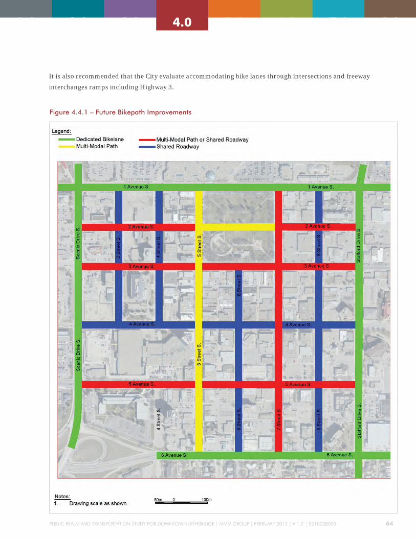
Public Realm and TRansPoRTaTion sTudy foR downTown leThbRidge | mmm gRouP | febRuaRy 2012 | v 1.2 | 5210038000 64
2.0 3.0 4.0 5.0 6.0 7.0 8.01.0 2.0 3.0 4.0 5.0 6.0 7.0 8.01.0
It is also recommended that the City evaluate accommodating bike lanes through intersections and freeway
interchanges ramps including Highway 3.
Figure 4.4.1 – Future Bikepath Improvements

Public Realm and TRansPoRTaTion sTudy foR downTown leThbRidge | mmm gRouP | febRuaRy 2012 | v 1.2 | 5210038000 65
2.0 3.0 4.0 5.0 6.0 7.0 8.01.0 2.0 3.0 4.0 5.0 6.0 7.0 8.01.0
4.5 TRANSIT TREATMENT
4.5.1 BUS STOP PLATFORMS
The design of a bus stop is often a function of the
location and level of usage. They must be designed
and constructed to be accessible, given the limitations
of available space. Whilst planning street work
accessibility for bus stops should be considered.
Bus stop areas need to provide adequate space for
people waiting, entering and exiting. Passengers
waiting for a bus must not obstruct the sidewalk
or passengers boarding and alighting the bus. The
following is a general guideline for bus platform
accessibility:
» The platform is to be directly accessible with a hard
surface, and not separated by grass, uneven paving,
grade-level changes, or other obstruction.
» Remove or relocate non-essential street furniture
from the area; eliminate hazards such as support
cables from utility poles and low signage protruding
into the travel path.
» Provide tactile paving at boarding points to aid the
visually impaired.
» If cyclists are anticipated then ensure there is
sufficient space for passengers to wait with their
bikes and that any locked bicycles will not obstruct
the sidewalk.
CURBSIDE STOP
» Curbside stops are typically installed alongside
existing sidewalks and within the parking lane.
» The length of the stop`s curb may be coloured to
discourage parking.
» A curbside stop is simple in design and inexpensive
to construct.
» Drivers may have difficulty in parking flush with the
stop`s curb if not enough entering clearance is given
by nearby parked vehicles. However, special curbs
(Kassel Curbs) can be installed to guide buses to the
stop and also aid passengers in wheelchairs to enter/
exit the vehicles (if using low floor buses).
» Difficulties for buses re-entering traffic – this issue
may be resolved with campaigns encouraging
vehicles to yield to transit signaling to re-enter the
travel lane.
Bus bays provide an area for buses to leave the main
road to pick up or drop off passengers. They allow
passengers to board and alight when the bus is out
of the travel lane and therefore cause minimum
disruption to through traffic. However, buses may have
problems re-entering the main travel lanes.
General characteristics of bus bays include:
» allows passengers to board and exit outside of the
travel lane
» provides a protected area for the bus away from
traffic
» reduces delay to through traffic
» may present problems for buses to re-enter traffic.
» can be difficult and expensive to relocate

Public Realm and TRansPoRTaTion sTudy foR downTown leThbRidge | mmm gRouP | febRuaRy 2012 | v 1.2 | 5210038000 66
2.0 3.0 4.0 5.0 6.0 7.0 8.01.0 2.0 3.0 4.0 5.0 6.0 7.0 8.01.0
SHELTER
A bus shelter provides protection from inclement weather and some
protection from noise or spray from passing vehicles. A shelter should
have some form of seating and transparent walls, to improve visibility.
The shelter should be illuminated and there should be a copy of the bus
timetable and route map, located on the back wall. Information in relevant
languages and also in braille should be provided. Bus shelters also provide
opportunities to go beyond utility into creative design that enriches the
public realm.
AMENITIES
» Benches are provided for additional seating outside the bus shelter.
» Bicycle storage facilities provide convenience for cyclists using transit.
» Garbage/recycling receptacles will help reduce litter but will need to be
emptied on a regular basis.
» The use of a real-time passenger information (RTPI) display boards
will increase public confidence in the reliability of the source as well as
provide a real impetus to use transit with such systems implemented in
locations like Banff, Alberta.
BUS PLATFORM LAYOUT
The typical bus platform layout needs to provide a large, clear safety
zone for passengers that will not obstruct active pedestrian flow along
sidewalks. Bus shelter locations and additional amenities are important
considerations in providing passengers with a clear zone. Figures
4.5.11 and 4.5.1.2 illustrate typical bus platform layouts in an urban
environment.
Figure 4.5.1 – Typical Bus Platform (Bus Shelter at End of Bus Zone)

Public Realm and TRansPoRTaTion sTudy foR downTown leThbRidge | mmm gRouP | febRuaRy 2012 | v 1.2 | 5210038000 67
2.0 3.0 4.0 5.0 6.0 7.0 8.01.0 2.0 3.0 4.0 5.0 6.0 7.0 8.01.0
Figure 4.5.2 – Typical Bus Platform (Bus Shelter in Middle of Bus Zone)
4.5.2 MAjOR TRANSIT CORRIDOR TREATMENTS
None of the selected streets are on the City’s major transit corridors.
However, it may be possible to adapt some of the suggested streetscapes
for adoption on the main transit corridor. The parallel parking, for
example, shown on the streetscape for 3 Avenue S could easily be changed
into a bus stop.
TRANSIT STOP LOCATIONS
When considering transit stop locations it is important to consider the
benefits and flaws of locating a stop before (near side) or after (far side)
of an intersection. If layby stops are used then, to minimise disruption to
the bus and other road users, the stop should be located on the far side
of the intersection. Curbside stops cause the most disruption to other
traffic located on the far side, but less disruption on the near side of the
intersection. Midblock stops are only preferable when located next to a site
that generates a lot of pedestrian activity such as outside an educational
facility or shopping centre. Consideration must be given when locating
midblock stops to discourage pedestrians crossing streets at unsignalized
locations. It may be beneficial to implement either a pedestrian crosswalk,
near the stop, or a barrier to channel pedestrians to a designated crossing
area.

Public Realm and TRansPoRTaTion sTudy foR downTown leThbRidge | mmm gRouP | febRuaRy 2012 | v 1.2 | 5210038000 68
2.0 3.0 4.0 5.0 6.0 7.0 8.01.0 2.0 3.0 4.0 5.0 6.0 7.0 8.01.0
PROVISION FOR QUEUE jUMPS
In areas of significant traffic congestion, provision should be made to
allow transit vehicles to gain priority – perhaps by enabling them to move
to the front of a queue. In cases where transit vehicles are approaching
a major intersection and intend to turn left, for example, there could be
a provision of an initial signalized stop line prior to the stop line at the
intersection. Priority could be given to the transit vehicle by means of a
bus pre-signal, which allows the bus to manoeuvre into the left-hand lane,
ahead of other traffic.
The use of queue bypass lanes is another effective technique that allows
buses to gain priority over the road users. In most cases these can be
implemented with only a slight increase in delay to the road users.
It should be recognized that queuing buses could interfere with the
operations of right-turning vehicles, and consideration for the potential
number of queuing buses must be given. Conversely, the potential queuing
of right-turning vehicles could interfere with the ability of the turning lane
to function as a transit queue jump lane.
SIGNAL PRIORITY
Signal priority at signalized intersections can provide buses with
operational advantages over traffic on a mixed flow lane. Buses should be
equipped with transponders (or similar devices) capable of being detected
by loops or other detector devices stationed upstream of the intersection. A
priority message is then sent to the traffic signal controller and the signal
timing is adjusted accordingly.

Public Realm and TRansPoRTaTion sTudy foR downTown leThbRidge | mmm gRouP | febRuaRy 2012 | v 1.2 | 5210038000 69
2.0 3.0 4.0 5.0 6.0 7.0 8.01.0 2.0 3.0 4.0 5.0 6.0 7.0 8.01.0
4.6 PARKING STRATEGY
The City of Lethbridge has requested a “go forward”
strategy for public parking development and
systems management for its 2011 Public Realm and
Transportation Study.
A Strategy is a high level plan outlining general
function, direction and goals arising from the
observations and recommendations identified within
this study, including:
1. Lethbridge has very wide streets, and a large
element of its Right of Way allocation has been
dedicated to Angle-style public parking. Angle
parking requires very generous roadway widths,
and parks approximately 50% more vehicles
than a parallel parking configuration. As a result,
Lethbridge has quite a large supply of On Street
parking as compared to most mid-size and larger
cities.
2. While some blocks show 100% occupancy at some
peak times, utilization of all On Street parking stalls
at peak periods show about 60% occupancy. This
suggests that there is a very generous supply of On
Street parking in the City, quite a lot of long term
parking occurring on the street, and that turnover is
not being achieved in some high demand areas.
3. The great majority of Off Street parking stalls are
in private hands and controlled for specified uses
only (reserved parking, customers of individual
business, etc.). The use of street parking for long
term parking suggests that the existing stock of Off
Street stalls is not absorbing longer stay parkers.
4. Although some public Off Street stalls exist, the
primary Off street use is private space reserved for
individuals or customers of individual businesses.
These surface lots generally exhibit 60% occupancy
as well.
5. There is currently surplus parking capacity
available to accommodate anticipated future growth
throughout the Downtown. Should current trends
continue and future developments materialize,
there will be increased parking pressure on the
Northwest and Southwest Quadrants of the
Downtown, yet not sufficient pressure to warrant
construction of a parking garage.
Understanding this current reality, and following from
the results of the Public Realm and Transportation
Study, MMM group understands that the City wishes
to evolve a program of change in its public parking
posture to more closely support its larger strategic
development goals. A number of detailed observations
and comments are provided below.
4.6.1 CONCEPTS AND CHOICES
From the beginnings of human civilization, individuals
and groups have required access to facilities, goods

Public Realm and TRansPoRTaTion sTudy foR downTown leThbRidge | mmm gRouP | febRuaRy 2012 | v 1.2 | 5210038000 70
2.0 3.0 4.0 5.0 6.0 7.0 8.01.0 2.0 3.0 4.0 5.0 6.0 7.0 8.01.0
and services, and have needed to move easily between
areas. Efficient transportation is a key ingredient for
any successful community. Parking is a key ingredient
for any balanced and successful transportation
program, and so efficient Parking facilities and
services deliver access and mobility to people and
communities.
Greatest efficiency in delivery of Parking facilities and
services is arrived at by creating harmony between:
a) Efficiency to the individual; representing the
most convenient and least resource consumptive
solution for each individual.
b) Efficiency to the community; representing the most
cost effective and least resource intensive solution
for the community.
As the first element of efficiency is subjective and
defined individually, and the second element is
objective and defined collectively, the elements often
interact as opposing forces; consequently the point
of harmony between these forces is found in the
region of interaction where they are least powerful,
and where an optimum, or compromise, or point of
availability
convenience
safety security
Price
Proximity
Turnover
cost Recovery
management
monitoring
inventory
opportunity
efficiency
sharing
cost
Individual Community
efficient sharing is most available. Parking is about
people; an optimized parking program delivers the
greatest opportunity for people to interact and achieve
subjective goals in an objective world.
The goal of a Parking Strategy is to create an optimized
parking program that continuously adjusts to support
evolving community needs and aspirations.
As each community has different needs and
aspirations, and as each community is on a different
point in its unique and evolving trajectory of growth
and development, thematic decisions regarding how
policies are to be employed are usually identified as
Guiding Principles.
The identified tools for use in addressing Guiding
Principles are Best Practices.
Best Practices include:
Figure 4.6.1 – Intersection between the individual and the community

Public Realm and TRansPoRTaTion sTudy foR downTown leThbRidge | mmm gRouP | febRuaRy 2012 | v 1.2 | 5210038000 71
2.0 3.0 4.0 5.0 6.0 7.0 8.01.0 2.0 3.0 4.0 5.0 6.0 7.0 8.01.0
a) Parking supply and demand recognition –
Parking supply is usually greater than demand
in North American cities. In some areas –
Downtowns, universities, medical centres, etc. –
local demand is greater than local supply. Where
demand is greater than supply, sharing of space is
required, and this takes the form of regulation of
time allowance and pricing.
b) Regulation of time allowance and pricing –
These are the two management tools commonly
used to supress demand; they regulate the length
of time vehicles are parked in a space, creating
turnover and more availability of space through
increases sharing. Both tools require an active
compliance program to be effective. Regulation
of time allowance is the weaker of the tools and is
effective only in low demand areas; it is unpopular
with the public and usually does not recover its
cost. Pricing for parking is the more effective
tool, encouraging users to access their consumer
training in thrift and value; it is less unpopular
with the public, and usually recovers more than
its cost. The correct price to charge for parking is
the price point that supresses demand to desired
level, which is typically 85% occupancy (or 15%
availability) of parking space in given block or in a
given locality.
c) Compliance – The desired result of a parking
“enforcement” or compliance management
program. Compliance Management utilizes
regulation, reinforced by monitoring and financial
or social penalties, to achieve the desired level
of demand suppression, resulting in increased
turnover and availability of space. Unfortunately,
compliance management is usually a form
of negative reinforcement – punishment for
individuals or groups who do not comply with the
regulation and, therefore, overcome its purpose, to
the disadvantage of others; unfortunately, effective
compliance management is often perceived
negatively by the public.
The Compliance Management tool is only effective
when:
» the frequency of monitoring is harmonized
with the regulation (ie. When a two hour time
restriction is reinforced by compliance patrols
within the same period – every two hours)
» the value of the financial or social penalty is
sufficient to reinforce the regulation, deter
non-compliance, and deliver what the offender
will consider to be a meaningful punishment
and deter a repeat action, relative to the local
economy. (ie. A $5 fine for misuse of Disability
Parking Stalls is not sufficient to deter repeat
misuse)
» the value of the financial or other penalty is
seen to match the lost value associated with the
offence (ie. Fines for non-payment of parking
meters are reasonably related to the value lost by
that activity, typically 10X the average fee paid
per transaction)
» if the punishment is routinely reinforced on
appeal to higher or different authority (ie. The
punishment is not overturned by the Courts or
local politicians)
While enforcement and compliance management
programs are necessary to give “backbone” to the
parking and transportation program, they are
difficult to operate, naturally attract criticism, and
are not located high on the list of civic priorities.
Many enforcement programs operate as a matter of

Public Realm and TRansPoRTaTion sTudy foR downTown leThbRidge | mmm gRouP | febRuaRy 2012 | v 1.2 | 5210038000 72
2.0 3.0 4.0 5.0 6.0 7.0 8.01.0 2.0 3.0 4.0 5.0 6.0 7.0 8.01.0
routine, and compliance officers have lost the sense
of daily awareness and energy that is regularly
required to closely relate the use of the compliance
tool to the creation of the desired outcome. As
a consequence, over time, many enforcement
programs fall into a malaise: they enforce offences
by routine, generally lack credibility with the public,
become increasingly unreliable and unpopular,
and their output is increasingly challenged and
overturned by higher authority. Compliance
programs that trend in this direction focus on the
“letter of the law” and do not support a balanced
transportation program.
A compliance program that is working correctly
and delivers a positive result is fine tuned to deliver
service in scope and scale to the needs expressed by
stakeholders and addressed by the regulation effort.
d) Permissions or permits – Represent a full or
partial exemption from the regulation applied to
designated groups or individuals, usually as an
encouragement or enticement to utilize available
parking in a selected area or for a strategic
purpose. Monthly permits for Off Street parking
lots are usually significantly discounted over the
accumulated daily rate for a month’s parking;
similarly residents are often exempted from time
restrictions or meter fees in areas where residential
land use is encouraged.
e) Customer and Stakeholder Preferences – or
observed industry or local norms - establish a base
for customer/und user behaviour. (ie. Usually,
transportation consumers prefer personal vehicle
use over transit, until such time as parking is
more costly that transit, and then they trend in the
opposite direction). Customer preferences are not
always expressed verbally; parking customers “vote
with their feet” and often do things, out of habit,
impulse, or urge for convenience, that they would
not consider that they would ever do, thinking
rationally. In considering customer preferences it
is important to note:
» What do customers need? This is an objective
observation: it is important to understand the
physical and practical needs of individuals in
pursuing their personal requirement for efficient
access and mobility. (ie. “I require an exemption
because I am disabled and unable to climb the
stairs”).
» What do customers want? This is a subjective
observation: it is important to understand the
emotional needs of individuals in pursuing
access and mobility solutions in their daily
lives. Customer desires are often expressed in
emotional terms, and are very often disguised
as practical needs in order to gain greater
expression. (ie. “I need an exemption because I
might be late for the concert”).
» What are customers accustomed to? This is
an intuitive observation: it is important to
understand the routine and accepted small
processes and activities that individuals
repeatedly encounter and work through in their
day to day lives. (ie. Red means Stop; Green
means Go”).

Public Realm and TRansPoRTaTion sTudy foR downTown leThbRidge | mmm gRouP | febRuaRy 2012 | v 1.2 | 5210038000 73
2.0 3.0 4.0 5.0 6.0 7.0 8.01.0 2.0 3.0 4.0 5.0 6.0 7.0 8.01.0
4.6.2 PUBLIC PRIVATE RELATIONSHIPS
For the customer, Parking is a uniform product that is not necessarily
related to a particular location or service, except in that it provides
convenience to desired services generally. Customers often flow from
one parking environment to another. It is important to understand
the relationship that exists between On Street Parking (in the Public
Realm, which is usually municipally owned and operated) and Off Street
properties offering parking services (which are usually privately owned
and operated).
1. Value on the streets will build value off the streets; property values are
favourably impacted by paid street parking, and adversely impacted by
free street parking
2. Value off the streets will build more facilities; increased property values
create greater opportunity for private borrowing and an incentive to
redevelop to a higher and better use.
3. Restriction in off street spaces + incentives will build parking garages;
parkades are typically expensive assets to build and do not start to
recover cost in their first 10 years. Restriction of stall supply creates
higher pricing, which improves business plans for these facilities.
4. Nobody comes Downtown to park; customers are not attracted to the
Downtown by low cost parking, they are drawn by an inviting and
unique environment that they wish to be part of – low parking fees
have no positive effect on commerce. High or misunderstood pricing,
or poor amenities or services, however, have the ability to deter growth
and parking fees must be accompanied by positive improvements to the
commercial and public environment to have positive effect.
5. Compliance Management is the Backbone; as all parking management
is based on compliance, a reasonable, proactive, community minded,
and service results driven compliance program benefits both public and
private sector operations and builds value in the Downtown.

Public Realm and TRansPoRTaTion sTudy foR downTown leThbRidge | mmm gRouP | febRuaRy 2012 | v 1.2 | 5210038000 74
2.0 3.0 4.0 5.0 6.0 7.0 8.01.0 2.0 3.0 4.0 5.0 6.0 7.0 8.01.0
4.6.3 GUIDING PRINCIPLES
Guiding Principles indicate the theme, interpretation
or “flavour” of how the parking program works for
the community. They reflect current practices and
local realities, but, more importantly, identify larger
community standards, goals and aspirations.
It is suggested that important Guiding Principles in the
City of Lethbridge should be:
1. As a general rule, On and Off Street Parking assets
should pay for themselves and not be subsidized by
tax revenue.
2. Where a unique situation requires a taxpayer
subsidy, the extent of the cost to the public will be
carefully assessed against the value of the benefit to
the public, and not to individuals.
3. Where regulations are created and applied on both
public and private properties, clear and ample
signage will be posted
4. Where parking is offered to the public by the
private sector, a physical amenity and maintenance
standard and code of ethics will be applied.
5. Where a price is charged for parking, it will be fair
and based on the cost of providing the service.
6. Where land is available for use as a parking lot,
such use will not be approved unless the need is
clearly demonstrated.
7. The primary purpose for public streets and right of
way is for movement of people goods and services;
parking is an “opportunity only” use.
8. The primary use of parking meters is to generate
vehicle turnover
9. There should be a minimum of 15% available stalls
at peak use periods at every curbside.
10. Where public land is available for parking use, and
where such community need is demonstrated, it
will be available for all members of the public based
on an appropriate cost recovery program.
11. Where net revenues are earned by the Parking
resource, they will be applied back to replace,
enhance, or enhance the use of that resource.
12. Compliance management must be consistent and
fair to all
13. It is the responsibility of the City to explain, and
Stakeholders to understand, the role of compliance
in managing parking space availability
The City may wish to apply additional Guiding
Principles to its Parking Strategy.

Public Realm and TRansPoRTaTion sTudy foR downTown leThbRidge | mmm gRouP | febRuaRy 2012 | v 1.2 | 5210038000 75
2.0 3.0 4.0 5.0 6.0 7.0 8.01.0 2.0 3.0 4.0 5.0 6.0 7.0 8.01.0
4.6.4 PARKING INVENTORY
Current Condition:
The Current condition of the City parking inventory is closely detailed in
the Public Realm and Transportation Study Technical Report; Lethbridge
Downtown Parking – Existing and Short Term Future Parking Conditions
Observations and Recommendations:
Based on the prevalence on angle parking and moderate utilization of
existing On Street assets, there is significant unused parking capacity
throughout most of the Downtown. This capacity could be consumed,
either through future growth, or through strategic reassignment of space
to other Public Realm uses.
1. Angle parking typically creates up to 50% more parking stalls than
parallel parking; as a consequence, under existing conditions,
conversion of some of the 1,827 angle spaces to parallel-style parking
would reduce overall parking supply by up to that amount (to about
1,350 stalls), suggesting that utilization of the remainder would
increase to 85% across the Downtown.
2. Conversion of all or some angle spaces to parallel will enrich other uses
of the Right of Way, and more quickly empower development of Off
Street facilities and structures.
3. The utilization of “private” lots areas for dedicated customer parking
or reserved individual parking creates an apparent wastage of 40%
of private Off Street stalls. The observation that “all stalls are sold
and allocated, but are unavailable for use” significantly reduces the
benefit that these areas can deliver. Increased sharing of these facilities
between scramble style parkers and daily hourly public parkers will
increase overall efficiency of this space by an estimated 30% (capacity
for another 900 vehicles Off Street).

Public Realm and TRansPoRTaTion sTudy foR downTown leThbRidge | mmm gRouP | febRuaRy 2012 | v 1.2 | 5210038000 76
2.0 3.0 4.0 5.0 6.0 7.0 8.01.0 2.0 3.0 4.0 5.0 6.0 7.0 8.01.0
4.6.5 PARKING OPERATIONS, SERVICES AND FACILITIES
Current Condition:
At present, City owned public parking facilities include 1,827 On Street
parking meters and 4 surface parking lots (446 stalls). Several other
City properties are leased to private entities and operated as reserved
parking for single businesses. Municipal parking operations in City owned
and operated facilities are managed by a municipal parking manager
and a technician. Principal tasks include parking meter and surface
maintenance, problem resolution, and management of Monthly assigned
parking permits in the surface facilities. Monthly fees are below market
rate and there are wait lists for all lots. Revenues from parking operations
are used to pay the expenses of operations, and net revenues are assigned
to the Parking Reserve Fund. Meter and regulatory compliance in the
Public Right of Way is performed by Municipal By-Law Enforcement
Officers (current contract to the Corps of Commissionaires), and revenues
and expenses resulting from this function accrue to that budget unit. Net
Revenues from Enforcement accrue to General Revenue
Observations and Recommendations:
1. Rates for On Street parking are currently determined by means of an
informal survey of rates charged in other municipalities of comparable
size and composition. This is a flawed approach that results in
duplication of other cities’ parking problems. As parking meters exist
to create turnover of On Street space in support of the merchant and
commercial community, rates should be determined by means of
annual measurement of On Street supply and demand at peak use, and
calculated at the level necessary to create 15% availability of parking
space at peak use periods. This principle establishes the “market rate”
for the Public Right of Way and creates a condition whereby parking
space is continuously available and businesses can grow and Parking
can expand into Off Street locations.
2. At present, both short and long term meter parking are permitted
on most city blocks. While this utilizes excess On Street space to
accommodate long stay customers, when it is applied to high demand
areas, it creates a duplicate customer search pattern, excessive
circulating traffic, and detracts from value growth in Off Street
properties. On Street parking should be organized around High
Demand and Low Demand zones; meter prices should reflect the higher

Public Realm and TRansPoRTaTion sTudy foR downTown leThbRidge | mmm gRouP | febRuaRy 2012 | v 1.2 | 5210038000 77
2.0 3.0 4.0 5.0 6.0 7.0 8.01.0 2.0 3.0 4.0 5.0 6.0 7.0 8.01.0
demand level (ie. Price is double the Low Demand rate), and where
long term parking is offered On Street, it should be in Low Demand
areas only.
3. Rates for Off Street parking are determined by perceived value, or an
increase over “last year’s fee”; again, these rates should be determined
by supply and demand, and the correct price point for assigned stall
monthly parking is the fee that results in an absence of a waiting list.
4. Facilities for Off Street parking should offer a combination premium
priced Reserved/ Assigned parking, and lower priced unassigned or
“scramble” or “roaming” style permits that allow a parker access to any
City operated surface lot. Unassigned permits may be oversold by 10-
15% to allow for infrequent users. This program optimizes use of space
as well as financial return.
5. Facilities for Off Street parking should also allow for long term daily/
hourly use (ie. $ 1 per hours to a $ 6 daily maximum) to allow for
interchangeability between On and Off street use, as well as growth
in value of Off Street properties (this is essential in building an
environment which will create a business case of densification of Off
Street parking – a parking structure – in the future). Off Street facilities
should be equipped with modern daily rate Pay Station technology
consistent with the units customers are used to seeing On Street.
6. The City owns a significant number of surface properties in the
Downtown that are currently leased to private interests, and these
parking spaces are often reserved for special groups and provided to
customers free of charge. This practice restricts growth and mobility
in the Downtown. The City should operate these spaces directly, or
acquire an operating partner that will manage the lots directly, as daily/
hourly/monthly parking areas, in the manner described above.
7. The City currently uses standard electronic parking meters to support
angle parking. These meters are no longer current or supported by
the industry. The City should plan to upgrade its meter inventory
to a modern solar powered pay station technology configured in an
advantageous manner (pay and display, pay by space, pay by plate).
These devices accept credit cards and Pay by Cell phone and Pay by
GPS technologies are supported. These devices increase service to
customers and revenues to the City, and, in some configurations, a
more efficient use of the Public Right of Way.

Public Realm and TRansPoRTaTion sTudy foR downTown leThbRidge | mmm gRouP | febRuaRy 2012 | v 1.2 | 5210038000 78
2.0 3.0 4.0 5.0 6.0 7.0 8.01.0 2.0 3.0 4.0 5.0 6.0 7.0 8.01.0
8. Enforcement technology should be upgraded to support hand held
computers for wireless individual By-Law Officers; an automated ticket
issuance program utilizing Licence Plate Recognition vehicles should
be considered.
9. Enforcement ticket rates are currently too low to represent an adequate
deterrent to committing a parking offence. Ticket rates should increase
to the point where, at a minimum, they represent a credible deterrent
to misuse, they refund the direct and indirect costs of ticket issuance
and adjudication, and replace any lost revenue associated with the
offence. In most cases where revenue is lost, violation fines are
calculated at 10 X the normal fee for the space identified (ie. If the fee
for 2 hours of parking is $2, the fine for misuse is $ 20).
10. Enforcement Officers for parking offences are often acquired through
contract agencies. Different agencies have different policies regarding
attendance and productivity. The City should conduct a study to
determine if the current contract is optimizing use of these staff. At a
minimum, the Enforcement contract should be put out for public bid
every 5 years.
11. The position of the Parking Manager is currently responsible for
customer service and daily maintenance. The position should be
expanded to include proactive daily management of the parking
resource, budget, and program, as well as stakeholder relations. In
the longer term, the City may consider assigning responsibility to this
position for management of the enforcement and compliance function,
and for management of the Parking Reserve, and funds accruing from
“cash in lieu of parking” payments. Ultimately, the City may wish to
establish a Parking Authority to take the lead in funding and developing
structured Off Street facilities.
12. The City is currently working with Downtown stakeholders on a variety
of committees that deal with planning and parking in the public realm.
The City should establish a long term Working Committee or Advisory
Group on Parking Programs to consult month to month in public
parking management issues.

Public Realm and TRansPoRTaTion sTudy foR downTown leThbRidge | mmm gRouP | febRuaRy 2012 | v 1.2 | 5210038000 79
2.0 3.0 4.0 5.0 6.0 7.0 8.01.0 2.0 3.0 4.0 5.0 6.0 7.0 8.01.0
4.6.6 PARKING STRUCTURES
Current Condition:
At present, the City has very few parking structures, in either the public
or private realm, and has identified a desire to work towards and
environment that will support the development of structures to locate
vehicle parking Off Street as a strategic goal.
The current lack of privately funded structured parking is indicative of a
market value for parking space that is generally not sufficient to pay the
significant costs of developing a new structure.
There is also a propensity for long term Downtown parkers to seek out
and misappropriate existing space that is made available free of charge
to private customers in private facilities (Park Place or Lethbridge
Centre), and this is indicative of a need for a more proactive, long term
construction goal.
The City currently retains a dedicated Reserve Fund for future parking
facility development; at present, net revenues from the existing parking
operation are contributed to the reserve. While there are significant funds
in the Reserve, there is no identified project for the city to save toward,
and so the Reserve is occasionally identified as surplus revenue and used
to address other expenses.
Observations and Recommendations:
1. Understanding that the City wishes to reconfigure and reduce On Street
parking supply as a strategic goal, planning for the development of
densified Off Street space should increase.
2. The current preferred configuration for Off Street structured parking
is multi-use or shared used (retail, commercial, residential, or
entertainment), 250-500 parking stalls, precast construction, footprint
and functional design to suit the selected site. Per stall costs for the
parking stall elements space are usually $ 30,000; there are additional
funds required to acquire the land and construct the building envelope.
The typical capital construction cost of such a structure – or of the
parking element of a multi-use structure - in 2011 dollars is $ 25
Million. The typical funding model is a combination of cash down
payment (25% of total) and annual mortgage over a 25 to 40 year
period, as sustained by an approved business case.

Public Realm and TRansPoRTaTion sTudy foR downTown leThbRidge | mmm gRouP | febRuaRy 2012 | v 1.2 | 5210038000 80
2.0 3.0 4.0 5.0 6.0 7.0 8.01.0 2.0 3.0 4.0 5.0 6.0 7.0 8.01.0
3. In addition to their capital construction costs, parking garages typically
generate $ 250,000 to $ 500,000 in operating costs each year (staffing,
utilities, repairs, snow removal). As parking structures are built to
provide future capacity, they are not usually fully occupied in the
first several years of operating; consequently the first several years
of operations incurs an annual deficit. The typical time to operating
profitability is a municipal parking structure is 5-10 years; as net
operating revenues are turned to debt repayment, facilities can be paid
down earlier than the initial mortgage requires.
4. The best business case for a structured parking facility involves
sharing uses of the parking space amongst different types of parkers to
maximize capacity, and sharing uses over the course of the business day
to stretch the period of the day in which parking stalls are utilized. For
instance, a facility may be used by retail and commercial traffic during
the day, and by restaurant and special event of concert parkers in the
evening and weekend time segments.
5. The business case for a parking structure may be improved though
revenue contributions from positive net revenues in other parking
modes (ie. Parking meters and permits) as well as by reductions in
supply in other key parking areas (ie. Conversion of On Street to
parallel parking)
6. The business case for a parking structure can be improved though
additional taxation surcharge or subsidy from other revenue generation
(ie. A business tax or a parking tax).
7. The business case for a parking structure may be improved through
assignment of capital costs to other aspects of the building’s use (ie.
Assignment of greater cost to the commercial component).
8. The typical time taken to develop a parking garage is: 1 year approvals,
site selection and acquisition; 1 year design; 1 year construction; 1 year
completion, commissioning and commence operations.
9. The best location for a parking structure is always in a central
Downtown location where the facility can achieve its greatest shared
use. Pairing of structures with centrally located residential, commercial,
event or entertainment centres is very common.
10. In Lethbridge, the best location for a parking structure will be centrally
located in a space that supports the proposed entertainment or arts
corridors, and future business growth zones, as may be determined
in future planning. There are several sites available that may, in the
fullness of time, support a business case.
Public Realm and TRansPoRTaTion sTudy foR downTown leThbRidge | mmm gRouP | febRuaRy 2012 | v 1.2 | 5210038000 81
2.0 3.0 4.0 5.0 6.0 7.0 8.01.0 2.0 3.0 4.0 5.0 6.0 7.0 8.01.0
11. The business case in Lethbridge does not yet support construction of
a parking garage. To push toward this solution as a strategic goal, the
City should consider the following program:
» Reduction of surplus On Street space through reassignment of Public
Right of Way to non parking uses, and conversion of angle parking to
parallel parking.
» Correctly price On Street meters and Off Street lots to demonstrate
15% availability, and assignment of net revenues from parking
meters and enforcement to the Parking Reserve.
» Develop a conceptual plan and self-funding financial pro forma for
a garage facility, incorporated into the overall conceptual design
and business plan for a larger scale mixed use facility or arts or
entertainment district. (Where possible, potential sites should not be
discussed until the larger designs are developed and properties are
in public hands.)
» Establish civic goals for these larger developments at an initial
timeline between 5 and 10 years.
4.6.7 ASSEMBLY OF TIMING AND ACTIONS
Near-term (within three years)
» Begin to reduce angle parking On Street and replace with parallel as new
uses for the Public Right of Way reach approval.
» Begin to increase meter fees toward 15% availability principle.
» Begin to increase fines to a reasonable deterrent or 10X the fee forgone.
» Adjust legislation to support principle of 15% availability of space On
Street.
» Create policy and begin to charge City staff for parking on City property
(daily/hourly/monthly).
» Implement daily/hourly parking in City owned lots (select and purchase
Pay and Display machines).
» Implement scramble parking in city owned lots (revise parking
regulations and practices).
» Curtail leasing of city parking properties and operate internally as daily/
hourly/monthly lots.
» Assign increased net revenues from fees and fines to the Parking
Reserve.

Public Realm and TRansPoRTaTion sTudy foR downTown leThbRidge | mmm gRouP | febRuaRy 2012 | v 1.2 | 5210038000 82
2.0 3.0 4.0 5.0 6.0 7.0 8.01.0 2.0 3.0 4.0 5.0 6.0 7.0 8.01.0
» Place signage and communications signalling that increased revenues
will be dedicated to a parking structure.
» Develop a conceptual plan for 1st parking inclusive project: artist’s
rendering, rough site plan, financial feasibility study; multi use structure
including parking space.
» Create a Downtown Parking Advisory Committee representing
stakeholders.
» Assign more proactive and development work to Parking Department;
improved training and staffing; customer service and stakeholder
support; Plan and execute the Parking Strategy day to day.
» Review Commissionaires contract and performance; convert
“Enforcement” to “Compliance Management.”
» Select and implement an automated permit and compliance data
management program.
Mid-term (3 to 6 years)
» Continue conversion of angle to parallel parking.
» Increase meter fees to create 15% availability (steady state).
» Increase fines to suitable deterrent level (steady state).
» Plan timing of 1st major project based on financial estimates. Continue
with formal planning toward approval and construction within this
period (if possible).
» Begin replacing On Street parking meters with Pay Station machines.
» Continue developing the “parking facilities and services” department.
» Adjust planning, zoning, and site planning by-laws and practices to be
more “parking and development friendly” to encourage redevelopment
of surface lots and build more parking garage development in key areas.
Long-term (6 to 15 years)
» Continue to reduce On Street parking as determined by growth in
alternative uses of the Public Realm.
» Construct 1st major parking inclusive project and commence conceptual
planning for 2nd and 3rd major projects to be developed as the City
grows.

Public Realm and TRansPoRTaTion sTudy foR downTown leThbRidge | mmm gRouP | febRuaRy 2012 | v 1.2 | 5210038000 83
2.0 3.0 4.0 5.0 6.0 7.0 8.01.0 2.0 3.0 4.0 5.0 6.0 7.0 8.01.0
5.1 PUBLIC CONSULTATION PROCESS
The public consultation process began with the MMM
Group developing a stakeholder consultation list and a
Communication Plan with the City’s Project Manager.
The objective of this process was to ensure that
commonly held values by local citizens representing
various interest groups were expressed during the
public engagement process.
Core team members included staff from City
Departments including Planning, Transportation,
Parks, and Transit. Copies of the Communication
Plan were distributed to both core and external
stakeholder groups including the HOCRC, local special
interest groups and organizations, residential and
condo associations, external municipal departments,
and individual land owners. (See Technical Reports
Appendix A for complete list of Core and External
Stakeholders). Table 5.1 on the following page is
a condensed list of the core participants and key
stakeholders groups involved in the charrette.
PUBlIC And STAkEHoldER ConSUlTATIon
The Communication Plan gave a brief introduction to
the charrette process. This included: key participants,
including the consultant team; a summary of key
issues of the transportation study such as freight,
universal accessibility, and active transportation;
background information on how the study streets were
selected; and an agenda for the four-day event that
outlined each day’s activities and timeframes.
The format of the design charrette process involved
a series of ‘listening’ sessions with the various
stakeholder groups; development of ‘big ideas’ through
design workshops with the various stakeholder groups;
stakeholder drop-in sessions to meet one-on-one
with the consultant team to discuss the refinement of
those ‘big ideas’; and finally a public open house to
present the refined ideas and elicit public feedback.
Documented public feedback consisted of exit surveys
which were distributed out at the public open house.

Public Realm and TRansPoRTaTion sTudy foR downTown leThbRidge | mmm gRouP | febRuaRy 2012 | v 1.2 | 5210038000 84
2.0 3.0 4.0 5.0 6.0 7.0 8.01.0 2.0 3.0 4.0 5.0 6.0 7.0 8.01.0
Table 5.1 - List of Core Participants at Design Charrette
Project Management and Development Team
Robert evans, mmm urban design, Principal in charge.
Robin hutchinson, mmm Transportation / Project manager
mark velicevic, mmm Transportation
david James, mmm landscape architecture
michael von hausen, mvh urban Planning and design
geoff dyer, Placemakers
nicholas wade, Public art consultant
City of Lethbridge
Tatsuyuki setta
george Kuhl
maureen gaehring
Jeff greene
ahmed ali
wade combs
Ryan carriere
Heart of Our City Revitalization Committee
Ken nakagama
bev lanz
mark bellamy
grace duff
belinda crowson
Renae barlow
alderman Jeff carlson
alderman Jeff coffman
Groups-Organizations-Government
business Revitalization Zone
chinook county Tourist association
bikebridge cycling association
economic development lethbridge
chamber of commerce lethbridge
allied arts council
lethbridge historical society
Park Place mall
disabled and barrier-free (individual)
canadian badlands
City Departments
land development
lethbridge Regional Police (downtown)
fire department
Planning and development services
Public operations (Road)
Public operations (Park)
facility services
lethbridge Public library
galt museum (tourism committee)
helen schuler nature centre
Land – Business Owners
along the selected streets

Public Realm and TRansPoRTaTion sTudy foR downTown leThbRidge | mmm gRouP | febRuaRy 2012 | v 1.2 | 5210038000 85
2.0 3.0 4.0 5.0 6.0 7.0 8.01.0 2.0 3.0 4.0 5.0 6.0 7.0 8.01.0
5.2 LISTENING SESSION
The first day of the charette consisted of meetings with City Planning
and Transportation staff, external stakeholders consisting of
community leaders, HOCRC and land owners to briefly describe the
goals and objectives of the PRATS Study and allow an opportunity for
an open sharing of thoughts and key issues which would need to be
addressed in the conceptual work that would follow.
The following key issues emerged from the listening session:
» lack of a “pedestrian first” emphasis in the Downtown and to place
design priority on pedestrians and bicyclists
» a perception that the Downtown is not safe during parts of the day
» limited connections to the Downtown for cyclists and pedestrians
along the outer edges
» a lack of activities, facilities, and programming in the Downtown
» the importance of Galt Gardens as a major destination, gathering
place and recreational amenity within the Downtown
» limited parking and associated need for convenient access to
businesses
» a need for more housing Downtown to increase activity and vitality
» seasonal (wind and snow) limitations and lack of facilities
5.3 STAKEHOLDER WORKSHOP
Goals of the stakeholder workshop/ design charrette were to directly
engage the participants in a creative, hands-on design session, where
small teams made up of representatives of each stakeholder group
are encouraged to collaborate and sketch ideas about: the public
realm potential for the selected study streets; individual issues to
build consensus; alternative treatments for the public realm and
transportation systems. Strategies for lane reduction and parking
space were key focus points. Finally, information generated was
collected for further analysis and to prepare conceptual public realm
designs.
facilitation of stakeholder meetings
Presentation of ideas from charrette / workshop

Public Realm and TRansPoRTaTion sTudy foR downTown leThbRidge | mmm gRouP | febRuaRy 2012 | v 1.2 | 5210038000 86
2.0 3.0 4.0 5.0 6.0 7.0 8.01.0 2.0 3.0 4.0 5.0 6.0 7.0 8.01.0
The stakeholder workshop/ design charrette session
produced or re-affirmed the following key ideas:
» create a family oriented Downtown
» slow down traffic in the Downtown core
» create ‘Attractor Factors’ - places that are attractive
and invite people to stay awhile
» enhance Galt Gardens as a key destination and
Downtown amenity
» provide Safe and Universal Access in the Downtown
for pedestrians
» extend cycling throughout the Downtown, and
promote other alternate modes of transportation
» design for ‘four seasons’ and night activities to
increase Downtown pedestrian usage
» reduce “Red Tape” for public realm innovations,
and streamlining decision process for ease of
implementation
5.4 DESIGN CHARRETTE
The majority of the design charrette involved the
consultant team developing the ‘big ideas’ and
responding to the key issues identified by the
stakeholders into a series of synthesized plans and
sketches (such as that shown in Figure 5.4.1). These
drawings visually illustrate potential public realm
improvements for the selected study streets.
Stakeholder and working sessions developed a clear
goal for the treatment of the public realm:
‘To create a balance between the public realm and
the traffic realm without a significant loss of on-
street parking, and enhance the overall quality of the
Downtown’s public realm for long term vitality and
promotion of the Downtown as a place to live, work,
play and learn.’
Figure 5.4.1 – Plan of 5 St S and 2 Ave S Produced at the Charrett

Public Realm and TRansPoRTaTion sTudy foR downTown leThbRidge | mmm gRouP | febRuaRy 2012 | v 1.2 | 5210038000 87
2.0 3.0 4.0 5.0 6.0 7.0 8.01.0 2.0 3.0 4.0 5.0 6.0 7.0 8.01.0
5.4.1 BALANCING THE PUBLIC AND VEHICULAR REALM
The current public realm conditions, as discussed in Section 2.2, favours
motorized vehicles. Based on existing street cross-sections developed by
MMM, indicating width of sidewalk in relationship to combined parking and
vehicle travel lanes, the following percentage of dedicated space for pedestrian
and vehicle movement exists:
» 5 Street S: 19% Public Realm, 81% Vehicular Realm (Figure 5.4.2)
» 2 Avenue S: 39% Public Realm, 61% Vehicular Realm
» 3 Avenue S: 35% Public Realm, 65% Vehicular Realm
The founders of Lethbridge, when they surveyed the Downtown, showed great
foresight in providing 30.5 metres (100 feet) right-of-way widths for the street
network. This foresight has allowed for greater flexibility in the treatment of
the vehicular and public realm than most cities.
From a preliminary transportation review, it was demonstrated that a
reduction in the number of travel lanes on 3 Avenue S and 5 Street S can occur
and provide an acceptable LOS (See Section 2.5) at the selected intersections.
The traffic analysis is based on a moderate growth rate of 1.7% per year for
vehicles and 3.0% for pedestrians-cyclists over a twenty year time period. The
reduction in the number of travel lanes allows for an increase in the width of
public space within street rights-of-way (the public realm also includes non-
street right-of way-space such as publicly owned property with buildings and
spaces like Galt Gardens) and provides more of a balance between the two.
Figure 5.4.2 – Existing 5 Street S (19% Public Realm; 81% Vehicular Realm)

Public Realm and TRansPoRTaTion sTudy foR downTown leThbRidge | mmm gRouP | febRuaRy 2012 | v 1.2 | 5210038000 88
2.0 3.0 4.0 5.0 6.0 7.0 8.01.0 2.0 3.0 4.0 5.0 6.0 7.0 8.01.0
From work developed in the charrette, a redistribution
of public and vehicular realm was targeted.
» 5 Street S: 46% Public Realm, 54% Vehicular Realm
(Figure 5.4.3)
» 2 Avenue S: 39% Public Realm, 61% Vehicular Realm
(remains the same)
» 3 Avenue S: 33% Public Realm, 67% Vehicular
Realm (Galt Gardens)
» 3 Avenue S: 41% Public Realm, 59% Vehicular Realm
(West of 5 St S)
An increase in space dedicated to non vehicular use
will allow for a greater level of articulation in the
streetscape treatment, more opportunities to provide
comfort elements for pedestrians and dedicated
circulation zones for bikes, pedestrians and vehicles.
These enhancements to the public realm will improve
safety, make streets more attractive and Downtown a
more desirable place to visit and spend time.
Figure 5.4.3 – Proposed 5 Street S (46% Public Realm; 54% Vehicular Realm)
5.4.2 ENHANCING THE PUBLIC REALM
Specific recommendations and objectives were
identified in the HOCMP in terms of celebrating the
uniqueness of Lethbridge’s Downtown districts. It also
identified key objectives for the creation of new public
spaces, gateways, public art installations and street
prototypes as part of the public realm enhancement.
Correspondingly, the charrette used the HOCMP
Guiding Framework as a starting point for further
study and testing of those ideas as they pertain to the
selected study streets. For the most part, PRATS work
closely matches the original framework identified
in the HOCMP, but with some modifications and
refinement based on the work completed as part of the
PRATS. A revised public realm framework concept is
provided in Figure 5.4.4.

Public Realm and TRansPoRTaTion sTudy foR downTown leThbRidge | mmm gRouP | febRuaRy 2012 | v 1.2 | 5210038000 89
2.0 3.0 4.0 5.0 6.0 7.0 8.01.0 2.0 3.0 4.0 5.0 6.0 7.0 8.01.0
5.4.3 ExPANDING ON THE HEART OF OUR CITY MASTER PLAN PUBLIC REALM FRAMEWORK
The Master Plan originally identified a hierarchy
street network comprised of five different street
prototypes. In the document, 5 Street S and 3 Avenue
S were both identified as Main Street types, with
similar treatments; and 2 Avenue S was identified as
a Promenade Street type. During the design charrette,
the significance of individual study streets within the
context of the Downtown Central District became
quickly apparent (Figure 5.4.5). The intensity of
current use, number of heritage buildings, adjacent
land uses and untapped development potential
started to inform the design decisions and proposed
treatments for individual streets.
This lead to the conceptual development of a variety
of ‘Street Precincts’ that would be unified through a
common treatment of elements and materials such as
paving, lighting, and site furnishing. The uniqueness of
each Street Precinct could in turn be celebrated though
the selective use of distinctive elements such as public
art opportunities, special paving in featured areas,
custom benches, accent lighting and varying street tree
planting.
5 Street S is seen as having three distinctive
transitional zones and both 2 Avenue S and 3 Avenue
S are seen with cultural significance owing to past
and current uses. These differences were identified
as potential for elaborating on in the treatment of the
public realm.
The following expands on the Master Plan street
prototypes for the selected study streets:
Figure 5.4.5 – Street PrecinctsFigure 5.4.4 – Public Realm Framework Concept

Public Realm and TRansPoRTaTion sTudy foR downTown leThbRidge | mmm gRouP | febRuaRy 2012 | v 1.2 | 5210038000 90
2.0 3.0 4.0 5.0 6.0 7.0 8.01.0 2.0 3.0 4.0 5.0 6.0 7.0 8.01.0
5 STREET S (FORMERLY ROUND STREET C.1905)
» 5 Street S is a major retail strip running north to
south, that changes in intensity and character from
more historic 2 and 3 storey structures in the north,
to a 12 storey structure at Lethbridge Centre, then
back to lower density generic building forms in the
south.
» A raised ‘scramble’ intersection is proposed where 5
Street S meets 3 and 4 Avenues S.
» A new shared pedestrian and multi-modal bikeway
is proposed for the 5 Street S corridor from 6 Avenue
S to Galt Gardens. This is in response to stakeholder
and charrette preferences to promote alternative
modes of transportation and the enhancement of
Galt Gardens as a family oriented destination place
and the ‘heart within the heart of our city”.
» On the east side to 5 Avenue S, which has more
established retail development, angled parking
is maintained rather than parallel as identified
in the HOCMP. Angled parking is seen as more
advantageous for shopping districts for patron
convenience and maximizing quantity of parking
stalls.
Figure 5.4.6 – 5 Street S and 3 Avenue S Intersection – Commercial Core

Public Realm and TRansPoRTaTion sTudy foR downTown leThbRidge | mmm gRouP | febRuaRy 2012 | v 1.2 | 5210038000 91
2.0 3.0 4.0 5.0 6.0 7.0 8.01.0 2.0 3.0 4.0 5.0 6.0 7.0 8.01.0
» Parallel parking is proposed for the west side of 5
Street S. The additional width created by parallel
parking allows for a separated bikeway within the
public realm zone, free of conflicts with automobiles.
This will improve safety and encourage more family
oriented biking into the Downtown (See Figure
5.4.7).
» In addition, the bikeway on the western side of 5
Street S directly corresponds to a proposed plaza
space in front of the Penny Building (new University
of Lethbridge building).
2 AVENUE S
» 2 Avenue S is envisioned as a highly pedestrianized
street that visually and physically connects a number
of multi-family developments across Scenic Drive S
to the Downtown and Galt Gardens.
» Vehicular movement will remain as two travels lanes
with angled parking on both sides.
» A double row of street trees is proposed on each
side of 2 Avenue S and will extend the ‘green’ of Galt
Gardens to Scenic Drive.
Figure 5.4.7 – 5 Street S – Commercial Core

Public Realm and TRansPoRTaTion sTudy foR downTown leThbRidge | mmm gRouP | febRuaRy 2012 | v 1.2 | 5210038000 92
2.0 3.0 4.0 5.0 6.0 7.0 8.01.0 2.0 3.0 4.0 5.0 6.0 7.0 8.01.0
» A more distinctive treatment of public realm
elements, such as the use of special street lighting
and custom site furnishing is proposed to recognize
and reinforce Chinatown’s cultural significance in
the development of Lethbridge (see Figure 5.4.8).
» The intersection of 5 Street S and 2 Avenue S is
proposed to be treated much like 6 Street S including
a shifted roadway at the intersection to provide more
flexible space for parking and outdoor gathering. On
larger event days, an entire section of 2 Avenue S and
5 Street S (in front of Galt Gardens) could be closed
off to traffic and used as an event space such as an
informal open market (see Figure 5.4.9).
» Future land use recommendations for the proposed
redevelopment of vacant lands include mixed-use
commercial and residential, with a strong preference
for a small (1500m2) grocery store to help support
residential use within the Downtown core.
3 AVENUE S (FORMERLY REDPATH STREET C.1905)
» 3 Avenue S, with its dynamic land use mix, historic
and contemporary architectural styling, along with
various cultural, civic and retail uses, provides the
framework for a vibrant streetscape treatment.
Building upon this vibrancy through the addition
of distinctive site elements, and promoting greater
public utilization of Galt Gardens as a central square
and Downtown destination, are key to the public
realm improvements.
» Providing three travel lanes (eastbound and
westbound lanes with a middle turning lane) will
allow for angled parking and an enhanced sidewalk
width along the north side which interfaces with Galt
Gardens, and parallel parking with a bikeway on the
south side.
» The parallel parking configuration between 7 Street
S and 5 Street S will allow for the preservation of
Figure 5.4.8 – 2 Avenue S – Chinatown

Public Realm and TRansPoRTaTion sTudy foR downTown leThbRidge | mmm gRouP | febRuaRy 2012 | v 1.2 | 5210038000 93
2.0 3.0 4.0 5.0 6.0 7.0 8.01.0 2.0 3.0 4.0 5.0 6.0 7.0 8.01.0
existing mature street trees and current sidewalk
width, with approximately 3.0m of additional
sidewalk width for a shared bikeway.
» This will provide greater bike safety by eliminating
automobile conflicts that currently exist along 3
Avenue S owing to the encroachment of parked
vehicles into the commuter bike lane.
5.5 PUBLIC REALM COMPONENTS
Lethbridge’s Downtown streets and sidewalks are
key components of the public realm and are some of
the most important gathering spaces available to the
public. As identified earlier, the goal for the treatment
of the public realm is to “create a balance between the
pedestrian space and the vehicular space without a
significant loss of on-street parking, and enhance the
overall quality of the Downtown’s public realm for
long term vitality and promotion of the Downtown as a
place to live and work.”
Figure 5.4.9 – 2 Avenue S – Events Venue

Public Realm and TRansPoRTaTion sTudy foR downTown leThbRidge | mmm gRouP | febRuaRy 2012 | v 1.2 | 5210038000 94
2.0 3.0 4.0 5.0 6.0 7.0 8.01.0 2.0 3.0 4.0 5.0 6.0 7.0 8.01.0
From discussions with stakeholders and user groups
it became apparent that to achieve this balance in
the public realm without a significant reduction in
parking, the parking would need to be the buffer
between pedestrian and vehicular space. One of
the major public realm refinements to the Heart of
Our City Master Plan, in terms of the streetscape
framework, is to provide angled parking wherever
possible, but elevate the parking to the same level as
the sidewalk.
When circumstances require additional sidewalk
frontage, then the parking can be easily shifted to
pedestrian use, transitioning the streetscape zones
to accommodate adjacent uses or desired streetscape
functions. This flexible parking will also provide
opportunities for enhanced treatment of paving
surfaces, temporary snow storage and may incorporate
passive storm water management systems to minimize
infrastructure costs and promote ground water
recharge and better urban forestry practices.
5.5.1 STREETSCAPE ZONES
The placement of streetscape elements within in
the public realm is important to ensure the urban
environment meets the needs of pedestrians. Sensitive
placement will promote a more livable and beautiful
Downtown that is better organized, thus making for
more functional and accessible public space for all
users.
Pedestrian movement is critical, but so is providing
comfort elements and shelter in order to encourage
users to stay and take advantage of all that Downtown
Lethbridge has to offer. There are opportunities to
enhance outdoor experiences and delight the public
through the provision of public art and custom urban
design elements. Careful placement of these distinctive
elements must also be considered.
In order to provide all the necessary streetscape
elements without negatively affecting pedestrian
circulation, the public realm is typically divided into
a number of Zones: an Edge Zone, Furnishing and
Planting Zone, Pedestrian Clearway Zone, Frontage
and Marketing Zone (See Figure 5.5.1).
The Edge Zone is immediately adjacent to
parking and provides a safety buffer against vehicle
encroachment into the adjacent Pedestrian Clearway
(shared bikeway zone). At a minimum, this Zone
should consist of a 0.6m wide concrete band with
metal traffic bollards in locations where the parking is
raised to the same vertical elevation as the sidewalk.
This zone is also the most desirable for the location
of shallow utilities for ease of access and to limit
disruption of adjacent building uses.
The Furniture and Planting Zone accommodates
street tree planting, lighting, site furniture and other
fixed objects. Site furniture and planting must also
be placed far enough away from the curb face to limit
conflicts with roadway activities.
The Pedestrian Clearway Zone must be kept free of
obstructions and provide a continuous linear pathway
of an appropriate width to serve anticipated pedestrian
flow, yet have easy access to furnishings for safety and
ease of amenities.
The Frontage and Marketing Zone is the area
directly in front of the building and/or property line.
It can be used as flow-out space, patios and outdoor
display areas for merchants. It can also be used to
separate pedestrians from window and building
surfaces that extend out from the face of the building.

Public Realm and TRansPoRTaTion sTudy foR downTown leThbRidge | mmm gRouP | febRuaRy 2012 | v 1.2 | 5210038000 95
2.0 3.0 4.0 5.0 6.0 7.0 8.01.0 2.0 3.0 4.0 5.0 6.0 7.0 8.01.0
Depending on the classification of a street, its adjacent
land use and its intensity of activity, the type of Zone
and spatial requirements can vary. In general it is
desirable to maximize the Pedestrian Clearway without
adversely affecting or limiting the other zones.
5.5.2 STREETSCAPE ELEMENTS - KIT OF PARTS DESIGN TOOLBOx
A number of opportunities exist to enhance the overall
quality and functionality of the public realm through
the provision of various basic streetscape amenities, as
well as elements of distinction. The greater the width
of the public space, the more flexibility there is in the
placement of these streetscape amenities.
Basic amenities are required to provide a minimum
amount of pedestrian comfort to encourage and
support pedestrian use. Examples include: parking
meters and ticket dispensers, street and pedestrian
lights, benches, bike racks, tree grates, traffic bollards
and paving material.
In addition to those basic elements, there are elements
of distinction that can be added to provide greater
articulation and meaning to a specific place. Examples
of these include: bus and transit shelters, way finding
and information kiosks, public art installations,
gateway features, custom benches, special paving, and
special effect lighting.
In a highly articulated public realm, such as an area of
cultural significance, even common utility and service
features should be treated with greater distinction.
Examples include; manhole covers, utility and traffic
control boxes, street signage, sidewalk markers and
crosswalks.
With such a variety of different site elements there
can be a tendency to create visual disorder if care is
not taken in their selection. The charrette process
developed a strategy for the selection of streetscape
elements. This strategy is based on unifying the
selected study streets through the identification of
“common elements” that are simple and elegant in
their character. The unique quality of each individual
street or Downtown district is reinforced by provision
of distinctive elements which can be custom made
urban design elements or installation of public art.
Figure 5.5.1 – Streetscape Zones with Flexible Parking/ Patio Space

Public Realm and TRansPoRTaTion sTudy foR downTown leThbRidge | mmm gRouP | febRuaRy 2012 | v 1.2 | 5210038000 96
2.0 3.0 4.0 5.0 6.0 7.0 8.01.0 2.0 3.0 4.0 5.0 6.0 7.0 8.01.0
The combination of both lead to the creation of a Kit of Parts Design Toolbox.
The following Kit of Parts Toolbox is suggested for the selected study streets.
It is based on a selection of common streetscape elements which are Historic,
Transitional or Contemporary in character. Recommendations for the use and
location of distinctive elements, along with possible urban design themes are
also indicated (See Figure 5.5.2 to 5.5.3).
Figure 5.5.2 – Kit of Parts – Common Elements
Figure 5.5.3 – Kit of Parts – Elements of Distinction

Public Realm and TRansPoRTaTion sTudy foR downTown leThbRidge | mmm gRouP | febRuaRy 2012 | v 1.2 | 5210038000 97
2.0 3.0 4.0 5.0 6.0 7.0 8.01.0 2.0 3.0 4.0 5.0 6.0 7.0 8.01.0
5.6 PUBLIC ART AND URBAN DESIGN
“Public Art provides an opportunity to celebrate and showcase local arts
and culture’ establish a unique identity for a District or development;
and, can contribute to enhancing the quality of the public realm”
~ excerpt from the Heart of Our City Master Plan’s Public Realm Framework
The City of Lethbridge has an active Arts and Cultural community. The
celebration of this community is evident in the numerous public art
installations throughout the City, especially within the Downtown. From
the charrette and integrated design process between stakeholders, the
design team, and its public art consultant, a number of potential Public
Art opportunities, themes and locations were identified. These include the
following:
5 STREET S AND 4 AVENUE S (NORTHWEST CORNER)
A Primarily Sculpture might be located at this important intersection
emphasising wind as a unique climate condition to the City of Lethbridge.
Formal Requests for Proposals (RFP’s) might be directed to designers,
artists and engineers to propose structures or machines which would have
entertainment and teaching value. It may be interactive in a way which
would be an attraction to all ages and relate directly to wind conditions at
this specific site.
Currently the City has a number of public art pieces that incorporate
wind as a theme. Part of the coordinated approach between the City and
Public Art Committee, for a primary sculpture piece such as this, will be
to consider structural soundness and regular maintenance as part of the
design and fabrication process.
One option is that the public art piece would be kinetic in design; in the
way that the mechanism of the structure reveals the physical nature of its
operating system and its dependence on wind as the source of its power.
There are numerous examples of wind driven public art installations, such
as wind driven mechanical instruments (wind harps), Sculptural mobiles,
and weather vanes.
Another option would be to mitigate the extreme wind conditions evident
at this corner and increase pedestrian comfort. This option could take the
shape of an aesthetically expressive form, and would require engineering
input in response to understanding wind flows and forces, as well as for
“The Trees” on stephen avenue, downtown calgary – Public art used to mitigate wind effects
“a departure”, ilan sandler, 2009 – Public art Piece at galt museum
Public art on 6 street south, downtown lethbridge – used to celebrate wind effects

Public Realm and TRansPoRTaTion sTudy foR downTown leThbRidge | mmm gRouP | febRuaRy 2012 | v 1.2 | 5210038000 98
2.0 3.0 4.0 5.0 6.0 7.0 8.01.0 2.0 3.0 4.0 5.0 6.0 7.0 8.01.0
the structural design of such an object. The public art
installation at Bankers Hall, along Calgary’s Stephen
Avenue Mall, is one such example of a wind migration
structure.
5 STREET S AND 2 AVENUE S (GALT GARDENS PLAZA ENTRY)
This potential public art location, which was also
identified in the HOCMP, could take the form of
a vertical marker and gateway feature into Galt
Gardens. The gateway option could replicate the 3
Avenue S brick colonnade gateway, or could be a new
contemporary interpretation taking its cue from the
SAAG. It could have a specific urban design function
over and above any aesthetic requirement. Its purpose
in design would be to help strengthen the physical
connection of the park to the Downtown.
Seen as an axial arrangement of vertical elements
based on the 2 Avenue S roadway alignment, with a
strong visual terminus inside the park, it could offer
an outstanding visual landmark identifying Galt
Gardens as a key destination along 2 Avenue S and its
immediate vicinity.
Potential themes for this particular location should
avoid the obvious, such as a clock tower which already
exists nearby at Park Place Mall. One potential
opportunity identified during the charrette is that of an
observation tower.
5 STREET S AND 6 AVENUE S (NORTHWEST CORNER)
The corner of 5 Street and 6 Avenue South was the
historic location of Lethbridge’s first hospital and until
most recently it’s Downtown Fire Station. Since the
completion of a new Downtown Fire Station on the
corner of Scenic Drive and 4 Avenue South, the City
of Lethbridge, in preparation for selling the land, has
parceled off and retained a corner of the property for
sidewalk widening and a small pocket park.
Retaining this strategic corner of 5 Street and 6 Avenue
South has created the potential to use public art to
serve as a gateway into the Downtown and marking 5
Street’s transition from commercial and retail into the
London Road neighbourhood (See Figure 5.6.1).
Figure 5.6.1 – 5 Street S – South Gateway Pocket Park with Public Art Sculpture

Public Realm and TRansPoRTaTion sTudy foR downTown leThbRidge | mmm gRouP | febRuaRy 2012 | v 1.2 | 5210038000 99
2.0 3.0 4.0 5.0 6.0 7.0 8.01.0 2.0 3.0 4.0 5.0 6.0 7.0 8.01.0
Owing to the close proximity to a residential area, a public art installation
is envisioned as a figurative representation in stone or bronze,
approximately 150 percent human scale, and set on a raised base within a
plaza pocket park. Potential themes for this location include a personage
(or a commemorative representation of a specific group) who has
contributed to the development of the city and the region. Other potential
themes of commemorative representations include mining history and
railway history to name but a few. Examples of personages of significance
to the City and Region include Sir Alexander Galt, Chief Crowfoot, and
Charles Magrath (Lethbridge’s first Mayor).
These themes are examples upon which the City, in conultation with the
Public Art Committee, can refine or further build upon at a detailed design
stage.
RELOCATION OF STEAM LOCOMOTIVE TO GALT GARDENS
One public art opportunity that was identified during the charrette and
garnered much support, is the relocation of the City’s historic steam
locomotive (#3651) from its present location behind the old train station
(City of Lethbridge’s Health Unit) on 1 Avenue, to a more prominent
location at the northwest corner of Galt Gardens (Figure 5.6.2). This would
effectively increase its visibility and create a strong ‘attraction factor’ for
Galt Gardens’ north end. The relocation would offer increased tourism
incentive and underline the historical and technological changes that have
occurred in the Downtown over the past century.
Ideally, the new location, and pavilion structure required to house the
locomotive to protect it from vandalism, would also support a new
Downtown shuttle terminal and relocated tourism office. The current
tourism office, located on 1 Avenue S west of Scenic Drive S, though
scenically situated overlooking the Brewery Hill Gardens, is not highly
visible or central to other tourism activities within the Downtown such
as the Galt Museum and the SAAG. Relocating the tourism office to Galt
Gardens would dramatically increase the tourism office’s visibility and
accessibility to potential visitors.
“The famous five” – by barbra Paterson – example of figurative sculpture
steam engine #3651 in downtown lethbridge

Public Realm and TRansPoRTaTion sTudy foR downTown leThbRidge | mmm gRouP | febRuaRy 2012 | v 1.2 | 5210038000 100
2.0 3.0 4.0 5.0 6.0 7.0 8.01.0 2.0 3.0 4.0 5.0 6.0 7.0 8.01.0
A new Downtown shuttle terminus should be located
in one of the most convenient locations, in terms
of visibility and accessibility, and would help to
promote alternative modes of transportation within
the Downtown. An important objective identified in
the HOCMP was to strengthen physical connections
between Park Place Mall, former location of railway
round house, and the Downtown core to increase
the economic potential and sustainability of the
Downtown.
The shuttle service would provide shoppers with
convenient access to potentially free public shuttle
Figure 5.6.2 – 5 Street S – North Gateway Downtown Shuttle and Tourism Office
service within the Downtown core and would function
much like the historic trollies that once looped
through the Downtown. There is a historic precedent
for re-establishing this shuttle service: 5 Street S was
originally named Round Street because of the trollies
that rounded 1 Avenue S onto 5 Street S.
As previously mentioned, the City of Lethbridge has an
active arts and culture community. It is recommended
that the City, in a coordinated effort with the Public Art
Committee, establish priorities, budgets and identify
funding opportunities to facilitate and implement
many of the public art ideas identified.

Public Realm and TRansPoRTaTion sTudy foR downTown leThbRidge | mmm gRouP | febRuaRy 2012 | v 1.2 | 5210038000 101
2.0 3.0 4.0 5.0 6.0 7.0 8.01.0 2.0 3.0 4.0 5.0 6.0 7.0 8.01.0
5.7 PUBLIC OPEN HOUSE AND PUBLIC FEEDBACK
An Open House was held on June 16th, 2011 to
present, to the stakeholder groups, ideas that were
generated during the charrette exercise as well as the
next steps in moving forward. The exit survey provided
to all in attendance elicited feedback and comments.
Copies of the Open House presentation and exit survey
were provided to the City for distribution and are also
included in Technical Reports Appendix D.
The following is a summary of what respondents were
“highly” satisfied with in the design approach (see
Figure 5.7.1):
» Overall the feedback has been positive, with 100% of
respondents agreeing that a balance between on-
street parking and wider sidewalks was needed.
» 60% satisfied with the design approach as presented;
40% mostly satisfied with the design approach.
» Improved infrastructure to support cycling within
the Downtown was positively received.
» 5 Street S was reconfirmed as a priority street.
» The focus of implementing public realm
improvements in a concentrated (historic) area of
the Downtown.
» Encouraging diversity of treatment in the public
realm to celebrate the ethnic diversity of the City
(through different cultural street festivals and
redevelopment of Chinatown), and encouraging
more outdoor uses such as street cafes, etc.
The following is a summary of what respondents were
“mostly” satisfied with in the design approach:
» on-street parking raised to the sidewalk level
» provision of wind mitigating site features (wind
baffles)
» shared pedestrian and biking lanes, with the focus
on recreational biking over commuter cycling
» winter maintenance
Generally there was support for the reduction of travel
lanes, with 80% in favour and 20% not in favour
(see Figure 5.7.2). From the comments received, the
greatest concern was the lane reduction on 3 Avenue,
between Stafford Drive and Scenic Drive, as it is a
main collector street, and connector through the
Downtown, connecting to Mayor Magrath Drive.
A summary of opinions and comments received,
as well as a sample of the exit survey is provided in
Appendix D.
Figure 5.7.1 – Concept Plan Design Approach Satisfaction
Figure 5.7.2 – Preference of 3 Avenue S Lane Reduction
CITY OF LETHBRIDGE - PUBLIC OPEN HOUSE COMMENTS - JUNE 16, 2011
Satisfied with the Design Approach and Concept Plans?
Yes No Mostly Yes No
X
I liked the 5 St concept as a whole and think it is #1 priority and then joining onto 2nd Ave. The corner flows nicely into some ethnic themes we could encourage ethnic festivals, etc. to celebrate ethnic diversity on City. The Avenue then flows down into a revitalized Chinatown. I didn't care for the community table. I fear negative use and users. Try to encourage street cafes etc. I think might work better. Broader sidewalk encourages this use.
Your approach and concepts are fine. Followed the basis of the Heart of the City Master Plan very well. I didn't see any significant gaps and your plan in my view falls within the perimeters of the Master Plan very nicely.
X X
Removing lanes on 3rd Avenue from, Stafford Drive westward to Scenic Drive would be an idea I could support. We could pick up more parking, slow traffic down and enhance the downtown more and more as a destination and stop it from being just a through way.
X Angle parking, wide sidewalks. "Spine" approach of 5th Street. Establish gateways.
Not yet. X X Appreciate slowing down the traffic. Remove jaywalking bylaw.
X Like wind baffles, raised parking & sidewalks. 3 Ave S should be reconsidered regarding restricting to 3 lanes. X X 3 Ave should remain 4 lanes
XLike that the focus is an smaller section of the Downtown 5 St, 3 Ave and 2nd Ave. The more historic areas of Downtown.
Not at this time. Must keep in mind winter maintenance issues.X X
Originally the 4 traffic lanes on 5 St and 3rd Ave were to move vehicles into and out of the Downtown. With less vehicle volume it is great to be able to provide more public space and parking.
X
Combined Park/Cycle/Others is a good approach for the next 20 years. What does it look like when we turn to a cycle culture. Traffic operations will be a challenge when using XX road cycle.
As I noted on Thursday 4 more square intersections of 4 Ave and 5 St would be better. In spite of 'transit' I believe it can be accomplished.
X X
I am concerned about the ability of traffic to move when combined with the park/unpack movement on the streets. The design needs to be sensitive to left turn X lengths. This could further slow down movement. I think that the reduction in lanes will cause some drivers to seek alternative routes which so both good and bad. Good luck. I look forward to seeing more. I work for Associated Engineering and we submitted a proposal for the project. I think you have assembled an excellent team and are doing a great job.
Summary
Support Reducing Vehicle Lanes?
Other Comments?Aspects you Like/Dislike Any Changes to the Design Approach and Concept Plans
Satisfied with the Design Approach and
Concept Plans?
Like the Idea of:Maximizing On-Street Parking/Narrower Sidewalk
Minimizing On-Street Parking/Broader Sidewalk
Create Balance of Parking/Sidewalk
Reduction of lanes on 3rd Avenue? 100% agree with creating a balance between providing on-street parking and increased sidewalk space.
80% In Favour 20% Not in Favour 60% Yes 0% No 40% Mostly
CITY OF LETHBRIDGE - PUBLIC OPEN HOUSE COMMENTS - JUNE 16, 2011
Satisfied with the Design Approach and Concept Plans?
Yes No Mostly Yes No
X
I liked the 5 St concept as a whole and think it is #1 priority and then joining onto 2nd Ave. The corner flows nicely into some ethnic themes we could encourage ethnic festivals, etc. to celebrate ethnic diversity on City. The Avenue then flows down into a revitalized Chinatown. I didn't care for the community table. I fear negative use and users. Try to encourage street cafes etc. I think might work better. Broader sidewalk encourages this use.
Your approach and concepts are fine. Followed the basis of the Heart of the City Master Plan very well. I didn't see any significant gaps and your plan in my view falls within the perimeters of the Master Plan very nicely.
X X
Removing lanes on 3rd Avenue from, Stafford Drive westward to Scenic Drive would be an idea I could support. We could pick up more parking, slow traffic down and enhance the downtown more and more as a destination and stop it from being just a through way.
X Angle parking, wide sidewalks. "Spine" approach of 5th Street. Establish gateways.
Not yet. X X Appreciate slowing down the traffic. Remove jaywalking bylaw.
X Like wind baffles, raised parking & sidewalks. 3 Ave S should be reconsidered regarding restricting to 3 lanes. X X 3 Ave should remain 4 lanes
XLike that the focus is an smaller section of the Downtown 5 St, 3 Ave and 2nd Ave. The more historic areas of Downtown.
Not at this time. Must keep in mind winter maintenance issues.X X
Originally the 4 traffic lanes on 5 St and 3rd Ave were to move vehicles into and out of the Downtown. With less vehicle volume it is great to be able to provide more public space and parking.
X
Combined Park/Cycle/Others is a good approach for the next 20 years. What does it look like when we turn to a cycle culture. Traffic operations will be a challenge when using XX road cycle.
As I noted on Thursday 4 more square intersections of 4 Ave and 5 St would be better. In spite of 'transit' I believe it can be accomplished.
X X
I am concerned about the ability of traffic to move when combined with the park/unpack movement on the streets. The design needs to be sensitive to left turn X lengths. This could further slow down movement. I think that the reduction in lanes will cause some drivers to seek alternative routes which so both good and bad. Good luck. I look forward to seeing more. I work for Associated Engineering and we submitted a proposal for the project. I think you have assembled an excellent team and are doing a great job.
Summary
Support Reducing Vehicle Lanes?
Other Comments?Aspects you Like/Dislike Any Changes to the Design Approach and Concept Plans
Satisfied with the Design Approach and
Concept Plans?
Like the Idea of:Maximizing On-Street Parking/Narrower Sidewalk
Minimizing On-Street Parking/Broader Sidewalk
Create Balance of Parking/Sidewalk
Reduction of lanes on 3rd Avenue? 100% agree with creating a balance between providing on-street parking and increased sidewalk space.
80% In Favour 20% Not in Favour
Satisfied with the Design Approach and Concept Plans?
60% Yes 0% No 40% Mostly

Public Realm and TRansPoRTaTion sTudy foR downTown leThbRidge | mmm gRouP | febRuaRy 2012 | v 1.2 | 5210038000 102
2.0 3.0 4.0 5.0 6.0 7.0 8.01.0 2.0 3.0 4.0 5.0 6.0 7.0 8.01.0
5.8 SUSTAINABILITY AND HIGH PERFORMANCE STREETSCAPE DESIGN
“Lethbridge balances the cultural, social, economic,
built, and natural environment dimensions of
sustainability; together we are building a City that is
a community – a legacy we are proud to pass on to
future generations.”
~ City of Lethbridge ‘Plan Your City Vision’ document (2009)
Completed in 2010, Lethbridge’s Integrated
Community Sustainability Plan / Municipal
Development Plan (ICSP/MDP) will guide future
City policy regarding land use, transportation and
infrastructure investment decisions. It is meant to
encourage and promote long-term sustainability and
conservation of resources for future generations. There
are ‘six dimensions’ of sustainability identified and
explained in the document:
» Economic
» Social Needs
» Cultural
» Built Environment
» Natural Environment
» Governance
These six dimensions of sustainability are inherently
interconnected, and while not all may directly be
applicable to the enhancement of Lethbridge’s
Downtown public realm, some can be directly
incorporated through ‘best practices’ and ‘green
initiatives’, which in turn can support the larger
objectives of the ICSP/MDP. For example; an
enhanced public realm may lead to increased
Downtown populations, in turn creating a more
compact and walkable City, and by extension
improved social and economic conditions and reduced
dependency on natural resources.
The following are examples of potential ‘best
practices’ and ‘green initiatives’ which could be used
to further enhance and support the public realm
recommendations already identified:
PUBLIC TRANSIT NETWORK
Lethbridge’s Downtown core and the study area in
particular, is well-serviced by public transportation,
with the following existing transit infrastructure:
» main Downtown ‘Transit Hub’ located on 4 Avenue
S, one block East of 5 Street S
» transit stop and shelter located directly on 3 Avenue
S at 7 Street S
» two (2) transit stops located within half a block of 2
Avenue S, on 3 Street S and Scenic Drive S
In addition, the following transit improvements are
proposed for the study area:
» Development of a ‘Downtown Shuttle’ near the
proposed relocated tourism centre - adjacent to Galt
Gardens at the corner of 5 Street S and 1 Avenue S
It is anticipated that the Shuttle would operate on a
looping system, allowing users to get on and off at
several locations throughout the Downtown.

Public Realm and TRansPoRTaTion sTudy foR downTown leThbRidge | mmm gRouP | febRuaRy 2012 | v 1.2 | 5210038000 103
2.0 3.0 4.0 5.0 6.0 7.0 8.01.0 2.0 3.0 4.0 5.0 6.0 7.0 8.01.0
» Build upon the Galt Museum walking tours, either
walking or shuttle based, to develop additional
new tours that within the Downtown core. This will
help to increase public awareness and education of
Lethbridge’s historical and cultural importance in
Southern Alberta, while increasing employment and
outside economic stimulus to the Downtown area.
ACTIVE MODES OF TRANSPORTATION
Active transportation refers to any form of human-
powered transportation, such as walking, running,
cycling, in-line skating, skateboarding and non-
motorized wheelchairs. By incorporating pedestrian-
friendly infrastructure Downtown for all ages and
abilities, and encouraging active living, there are
numerous benefits for Lethbridge’s citizens:
» Health: Provides residents and visitors with
opportunities to be physically active on a regular
basis.
» Social: Increases accessibility to public spaces and
provides more opportunities for social interactions.
» Transportation: Reduces road congestion by
diverting number of single-occupant vehicle trips.
» Environmental: Contributes to reductions in
greenhouse gas emissions and associated pollution.
» Economic: Both direct and indirect benefits of
reducing dependence on motorized transportation,
for municipalities, businesses and individual citizens.
The following strategies are proposed to accommodate
and encourage various forms of active transportation
in Lethbridge’s Downtown core:
» 2.5m - 3.5 meter wide ‘pedestrian clear zones’ on
both sides of 2 Avenue S and 3 Avenue S.
» 2.0m - 2.5 meter wide ‘pedestrian clear zones’ on
both sides of 5 Street S.
» 2.4m wide ‘multi-modal’ zone on one side of 5 Street
S, dedicated to accommodating recreational cyclists,
runners, children in strollers, etc.
» Re-designate 3 Avenue south and make 2 Avenue
South the principal bike route into the Downtown
from the east. The lower traffic volumes and direct
connection into Galt Gardens from 2 Avenue South
will greatly reduce cyclist and vehicle conflicts.
•Although not a selected study street, another
street towrds the south, such a 5 Avenue S, may
be considered as a principal bike route into the
Downtown.
» Scrambled and raised intersections at multiple
locations would give pedestrians priority in the
public realm and contribute to traffic calming
initiatives.
» Multiple locations for secure bicycle parking and
seating would allow users with limited mobility to
rest, increasing stamina and range.
» Bicycle storage and changing rooms with showers
could be implemented at Galt Gardens, as this is
a destination in the overall City park network and
would provide an ideal staging area for commuting
cyclists to walk or take the bus/ shuttle to their final
destination.
» As changing rooms and showers are seen as key
amenities in promoting communter cycling - the
City should look for opportunities to parnter with
the private sector to provide the kinds of facilities
and amenities needed, especially in areas of the
Downtown whcih have high concentrations of
workers.
encourage use of Public Transportation and cycling in the downtown core

Public Realm and TRansPoRTaTion sTudy foR downTown leThbRidge | mmm gRouP | febRuaRy 2012 | v 1.2 | 5210038000 104
2.0 3.0 4.0 5.0 6.0 7.0 8.01.0 2.0 3.0 4.0 5.0 6.0 7.0 8.01.0
» There is potential to connect to the Coal Banks Trail,
a 30 kilometer, uninterrupted pathway along the
Oldman River Valley, linking facilities and parks
throughout the City.
URBAN FOREST
Urban trees can significantly contribute to the
beauty of a City and its Downtown core. Increasing
the quantity, density, and diversity of urban trees
in Lethbridge’s Downtown public realm will have
multiple and significant benefits, including:
» reducing urban heat-island-effect by increasing
shade and minimizing sun in hard surface areas,
cooling the pavement on hot summer days and
reducing energy required to cool buildings in
summer
» contributing to the minimization of wind, noise, and
pollution
» increasing habitat for small mammals, birds and
insects
» reducing and treating stormwater run-off via water
uptake and evapotranspiration.
» incorporating seasonal variety in the short and
long term (eg: changing colour of leaves, winter vs.
summer appearance, etc.)
» generally contributing to increased property values
Trees living in urban environments face particular
urban stresses that are not typically found in their
native environments. Urban trees reach maximum
potential for environmental benefits after age 30, but
the average life-span of a Downtown urban tree is less
than 10 years. Compacted and poor soils, city streets,
driveways, underground utility services, a shortage
of water and nutrients, and increased road salt and
other pollutants are all common in urban areas.
These impacts can constrain tree roots and negatively
influence the growth and overall health of urban
trees, or even kill them. In addition, the frequent
Chinook winds in Lethbridge during the winter and
the associated rapid temperature fluctuations are often
detrimental to tree health.
For these reasons, it is essential that urban trees are
given every opportunity to not only survive, but thrive
in the urban landscape. Fortunately, urban forestry
is a rapidly developing field and there are many
innovative strategies currently being practiced that can
contribute to the long-term probability of successful
establishment:
» Specify tree species that are suitable for the proposed
climate and growing conditions. Where possible, use
plants native to the area or adaptive trees that have
been raised in local growing conditions.
» Provide diversity of tree species to protect against
the spread of disease and pests that can devastate
monoculture plantings (eg: Dutch Elm disease).
» Specific tree species should be coordinated with the
City’s Urban Forestry Plan.
» Maximize soil volumes and increase the area
available for root growth, which improves access
to required air, moisture, and nutrients. Design
strategies include planting trees in groups rather
than isolated pits, and providing trenches or
continuous soil zones so that roots from different
trees can share soil and nutrients.
street Trees contribute to beauty and benefit an urban environment

Public Realm and TRansPoRTaTion sTudy foR downTown leThbRidge | mmm gRouP | febRuaRy 2012 | v 1.2 | 5210038000 105
2.0 3.0 4.0 5.0 6.0 7.0 8.01.0 2.0 3.0 4.0 5.0 6.0 7.0 8.01.0
» Use structural soil or modular subsurface systems
(break-outs), particularly in areas constrained or
surrounded by impervious surfaces, to increase the
amount of available soil and associated nutrients
while maintaining the structural integrity of the base
materials required for hardscape surfaces such as
roads and sidewalks.
» Provide root barrier adjacent to sidewalks, utilities
and other vulnerable infrastructure, which direct
roots downward and reduce expensive and
complicated future conflicts and potential tree
removal.
» Provide supplemental water during establishment
period and sustained drought events.
STORMWATER MANAGEMENT
The conventional approach to stormwater
management in the past has been to remove rainfall
from urban areas as quickly as possible. Today,
knowledge about the environmental impact of
overloading streams and rivers during storm events
has prompted a more proactive, integrated planning
approach to urban stormwater management. Strategies
such as ‘low-impact development’ implement
small-scale hydrologic controls to replicate the pre-
development hydrologic characteristics of watersheds
through infiltrating, filtering, storing, evaporating, and
detaining surface run-off at its source. This approach
has the potential to provide the following benefits for
urban areas:
» Minimize damage from pollution to water sources
and aquatic ecosystems, particularly ‘first-flush’
pollutants.
» Reduce flooding incidents and severity due to
‘slowing’ of stormwater during storm events.
» Reduce impacts and loads on existing stormwater
infrastructure, potentially extending the service life
through increased capacity and ultimately reducing
the life-cycle costs.
» Reduce the use of potable water sources through re-
use of rainwater for irrigation purposes.
A good understanding of the overall watershed
management strategy and associated stormwater
management regulations and/or guidelines of a
particular region or municipality is essential when
developing a stormwater design. There are several
strategies that should be evaluated by the City of
Lethbridge based on the Downtown’s specific site
conditions, constraints, and available budget at the
time of construction:
» landscape areas that are capable of high rates
of stormwater absorption, infiltration, and
treatment, such as vegetated filter and buffer strips,
bioretention swales, rain gardens etc.
» permeable paving options such as Aquapave,
permeable asphalt, or permeable concrete
» infiltration structures such as perforated pipe, dry
wells, and rock pits
» sub-surface storage and retention/ detention
infrastructure to temporarily attenuate and store
runoff during peak storm events
» water quality inlets such as oil and grit separators,
media filters, etc
bio-infiltration swales and Rain gardens help Retain stormwater and Reduce infrastructure costs

Public Realm and TRansPoRTaTion sTudy foR downTown leThbRidge | mmm gRouP | febRuaRy 2012 | v 1.2 | 5210038000 106
2.0 3.0 4.0 5.0 6.0 7.0 8.01.0 2.0 3.0 4.0 5.0 6.0 7.0 8.01.0
IRRIGATION
Located in a semi-arid climate with low precipitation
(only 355mm (14”) annually on average) and high
occurrence of winds causing evapotranspiration
(over 115 days with winds of at least 40km/h), the
conservation and efficient use of water sources in
Lethbridge is essential in maintaining the long-term
sustainability of the region. To that end, there are
several strategies that can be employed in the design
and construction of irrigation and watering of trees,
shrubs, and perennials within the Downtown core:
» Planting native and/or regionally appropriate,
adaptive plant species that are drought tolerant
(commonly referred to as ‘xeriscaping’). Not only
will this reduce water consumption, but the plants
will require less fertilizer and pesticides, and less
maintenance overall.
» Use of an automatic timed irrigation system.
The City is currently employing a hand-watering
program, and although the initial one-time costs
of an irrigation system are more expensive, hand-
watering is less efficient, uses significantly more
water, and costs far more in the long-term when
considering the life-cycle costs of operating water
trucks and the associated labour.
» Sub-surface ‘drip manifold’ irrigation systems are
far more efficient than the use of ‘spray-style’ heads
and can dramatically reduce water consumption
by directly watering the tree root system; reducing
wasted water from over spraying on hard surfaces
and evaporation.
» Weather stations connected to automatic irrigation
timers that measure rainfall, wind speed,
temperature and evapotranspiration rates are
designed to water planting areas only when required.
» Non-potable irrigation opportunities, such as the
capture and re-use of stormwater from streets,
sidewalks, and roofs, the use of grey water from
nearby buildings, or the use of treated effluent
water (T.E.W.) are becoming increasingly common
throughout North America and should be seriously
considered as an alternative to the use of potable
water for irrigation, particularly for new construction
projects.
MINIMIZING URBAN FOOTPRINT
There are a host of ways to minimize the overall urban
footprint of a City or a particular project. It is essential
that the design and construction team is dedicated to
pushing the boundaries of conventional development
and construction, and exploring the use of sustainable
technologies that represent the ‘smart choice’ from a
long-term sustainability perspective:
» adaptive re-use of existing structures and materials,
including re-use and refurbishment
» environmentally preferable materials, such as
sustainably harvested / certified woods, recycled
materials, locally manufactured or extracted
materials, low embodied energy, etc.
» embracing energy conservation and adopting
renewable energy technologies (eg: use of LED or
Solar light fixtures and other infrastructure where
appropriate)
» high-albedo paving (light-coloured and reflective) to
reduce heat-island effect of hard surfaces
» waste management / recycling strategy (eg: Big Belly
Solar trash compactors and recycling stations)
» efficient and selective use of full cut-off lighting in
the public realm to adhere to ‘Dark Sky’ principles to
reduce light pollution

Public Realm and TRansPoRTaTion sTudy foR downTown leThbRidge | mmm gRouP | febRuaRy 2012 | v 1.2 | 5210038000 107
2.0 3.0 4.0 5.0 6.0 7.0 8.01.0 2.0 3.0 4.0 5.0 6.0 7.0 8.01.0
CLOSURE
In common with most cities and regions, the City
of Lethbridge has a unique climate, history, and set
of circumstances that have guided its current form
and character. The proposed streetscape features
outlined above are considered to represent current
‘best practices’ in sustainable infrastructure; however
their appropriateness for implementation in particular
situations should be evaluated carefully. While it may
be tempting to use the outlined features as a ‘shopping
list’ of the most current sustainable technologies, it is
the philosophy and principles incorporated throughout
the design process that are the most important factor
in contributing to the implementation of social,
economic, and environmental sustainability in the
built environment.

Public Realm and TRansPoRTaTion sTudy foR downTown leThbRidge | mmm gRouP | febRuaRy 2012 | v 1.2 | 5210038000 108
2.0 3.0 4.0 5.0 6.0 7.0 8.01.0 2.0 3.0 4.0 5.0 6.0 7.0 8.01.0
6.1 ROADWAY PRELIMINARY DESIGN
Preliminary roadway designs were developed from
the ideas developed through the public consultation
process Roadway engineering drawings were prepared
by applying the various Transportation Association of
Canada (TAC) roadway standards to ensure proposed
designs met with the minimum functional and safety
standards.
These engineering drawings established the basic
roadway structure over which the various public realm
enhancements and streetscape elements are applied.
Each study street Preliminary Design consists of: a
rendered Illustrative Plan, a Street Zone Plan, and
a Streetscape Layout plan. Typical roadway cross-
sections were also developed for each street.
The following outlines the refined defining
characteristics for each of the selected study streets
along with related preliminary designs which may be
referred to as pilots for similar Downtown streets.
6.1.1 5 STREET S ROADWAY DESIGN
5 Street S is a major retail corridor in the Downtown.
This street should be defined by its wide sidewalks
to accommodate high levels of pedestrian activity.
A wider sidewalk promenade is proposed along the
edges of Galt Gardens, featuring a double row of street
trees. There are two distinct characteristics defined
by the intensity of historic structures along the street:
more historic toward the core, transitioning from
commercial and office to residential south of 6th
Avenue. This change is proposed to be reflected in the
character of supportive common site elements such as
paving treatment, benches, trash receptacles, bollards,
and lighting.
Gathering spaces within the public realm are provided
at both ends, along with Public Art opportunities, to
create strong gateways into the Downtown and provide
opportunities for public interaction and understanding
of Lethbridge’s rich heritage.
A multi-modal bike lane on the west side of 5 Street
S would provide an improved connection for London
Road residents to the Galt Gardens. This would also
connect to the University of Lethbridge’s Downtown
building. A Downtown shuttle service hub is proposed
at the corner of 1 Avenue S and 5 Street S, as identified
in the HOCMP Streetscape Recommendations. Both
the shuttle and multi-modal corridor will provide
alternative methods for movement within the
Downtown.
PRElIMInARY dESIgnS

Public Realm and TRansPoRTaTion sTudy foR downTown leThbRidge | mmm gRouP | febRuaRy 2012 | v 1.2 | 5210038000 109
2.0 3.0 4.0 5.0 6.0 7.0 8.01.0 2.0 3.0 4.0 5.0 6.0 7.0 8.01.0
Characteristic features of 5 Street S include:
» two travel lanes, with a middle turning lane at each
intersection
» rolled curb between travel lanes and parking,
» parking raised to sidewalk level, allowing flexibility
of use for both pedestrian and vehicle use
» angled parking on the east side
» parallel parking on the west side
» a multi-modal corridor (recreational bike lane) is
located on the west side
» street trees on both sides, spaced at +/- 15meters
on-centre
» pedestrian lighting spaced at +/- 15meters on-centre
» a wide sidewalk on both sides that will accommodate
both a Pedestrian Clearway and Frontage Zones
along retail land uses
» a wide Promenade sidewalk on the east, adjacent to
Galt Gardens between 1 and 3 Avenues S
(See pullout of 5 Street S Concept - Illustrative Plans
and Sections)

Figure 6.1.1 – 5th Street South Concept Plans (A)

CITY OF LETHBRIDGEPUBLIC REALM &TRANSPORTATION STUDY
5th S
TRE
ET
ILLU
STR
ATI
VE
PLA
N
10 20 30 40 500
GALT GARDENSGALT GARDENSGALT GARDENS
2ND AVENUE FESTIVAL PLAZA
LETHBRIDGE HOTEL
EXPRESS COFFEE AND TEA
METCALFE BLOCK
OLIVERBUILDING
PENNY BUILDING
U of L
PENNY COFFEEHOUSE
ROUND STREET SCRAMBLED
INTERSECTION
AMPITHEATRE
SOUTHERN ALBERTA ART GALLERY
TOURISM / DOWNTOWN
SHUTTLE SERVICE
PARK PLACE MALL
5TH STREET SOUTH 5TH STREET SOUTH
1ST A
VE
NU
E S
OU
TH
2ND A
VE
NU
E S
OU
TH
3RD A
VE
NU
E S
OU
TH
5TH A
VE
NU
E S
OU
TH
6TH A
VE
NU
E S
OU
TH
4TH A
VE
NU
E S
OU
TH
5TH STREET SOUTH 5TH STREET SOUTH
QUIZNOSSUBS
LETHBRIDGE CENTRE
OFFICESPACE
ROUND STREET CAFE
MEDICAL CLINIC
LETHBRIDGEDENTAL
DENTAL OFFICE
STRIP MALL
MONGOLIAN GRILL
MUSIC STORE POCKET PARK
WALLACE BLOCK
TD TOWERS
4TH AVENUE SCRAMBLED
INTERSECTION
Figure 6.1.1 – 5th Street South Concept Plans (B)

Figure 6.1.1 – 5th Street South Concept Plans (C)

Figure 6.1.1 – 5th Street South Concept Plans (D)
GALT GARDEN

Figure 6.1.1 – 5th Street South Concept Plans (E)
PENNY CAFE PATIO

Figure 6.1.1 – 5th Street South Concept Plans (F)

Figure 6.1.1 – 5th Street South Concept Plans (G)

Figure 6.1.1 – 5th Street South Concept Plans (H)

Figure 6.1.1 – 5th Street South Concept Plans (I)

Figure 6.1.1 – 5th Street South Concept Plans (j)

Figure 6.1.1 – 5th Street South Concept Plans (K)

Public Realm and TRansPoRTaTion sTudy foR downTown leThbRidge | mmm gRouP | febRuaRy 2012 | v 1.2 | 5210038000 121
2.0 3.0 4.0 5.0 6.0 7.0 8.01.0 2.0 3.0 4.0 5.0 6.0 7.0 8.01.0
6.1.2 2 AVENUE S ROADWAY DESIGN
2 Avenue S will be a highly pedestrianized promenade
‘green street’ which continues the park character of
Galt Gardens westward, through the use of a double
row of street trees and wide sidewalks. In addition
to the generous sidewalks, there will be numerous
opportunities to expand adjacent land uses out into
the multi-use parking areas for alternative use such as
fesival activities.
It is anticipated that future development will include
mixed-use residential and commercial development
along 2 Avenue S, taking full advantage of the
enhanced public realm and expanded sidewalks.
Similar to 6 Street S, temporary closure of 2 Avenue S
between 4 and 5 Streets S to accommodate a festival
street that could be utilized for outdoor public markets
and to create a distinct precinct within the Downtown.
Between the blocks of 3 and 4 Streets S is the cultural
Chinatown District. While the extent of Chinatown is
relatively small, its significance to the development of
Lethbridge is large. Most of the cultural identity of this
area is best left to the renovation of existing heritage
structures However, a distinction in site furnishing
can greatly enhance the uniqueness of the block. It is
proposed that all site furnishing (lights, benches, trash
receptacles) be finished in a powder-coated red colour
(symbolic of prosperity in Chinese culture).
Characteristic features of 2 Avenue S include:
» two travel lanes
» rolled curb between travel lanes and parking
» parking raised to sidewalk level, allowing flexibility
of use for both pedestrian and vehicle use
» angled parking on both sides
» a double row of street trees on both sides of the
street
» pedestrian lighting spaced at +/- 15meters on-centre
» a flexible parking zone at the intersection of 5 Street
S, similar to the one that exists on 6 Street S
» use of red as a site furnishing colour to denote the
Chinatown Cultural District
(See pullout of 2 Avenue S Concept - Illustrative Plans
and Sections)

Figure 6.1.2 – 2nd Avenue Concept Plans (A)

CITY OF LETHBRIDGEPUBLIC REALM &TRANSPORTATION STUDY
2nd A
VE
NU
E IL
LUS
TRA
TIV
E P
LAN
10 20 30 40 500
GALT GARDENS
ORIGINAL#1
FIREHALL
LETHBRIDGEHOTEL
MIRO BISTRO
LETHBRIDGECHIROPRACTIC
FINE TUNED HOBBIES
CHINATOWN HERITAGE BUILDINGSHUMPTY’SRESTAURANT
CASTLE APARTMENT
COMPLEX
2nd STREET SOUTH
2nd STREET SOUTH
3RD S
TRE
ET
SO
UTH
SC
EN
IC D
RIV
E S
OU
TH
4TH S
TRE
ET
SO
UTH
5TH S
TRE
ET
SO
UTH
Figure 6.1.2 – 2nd Avenue Concept Plans (B)

Figure 6.1.2 – 2nd Avenue Concept Plans (C)
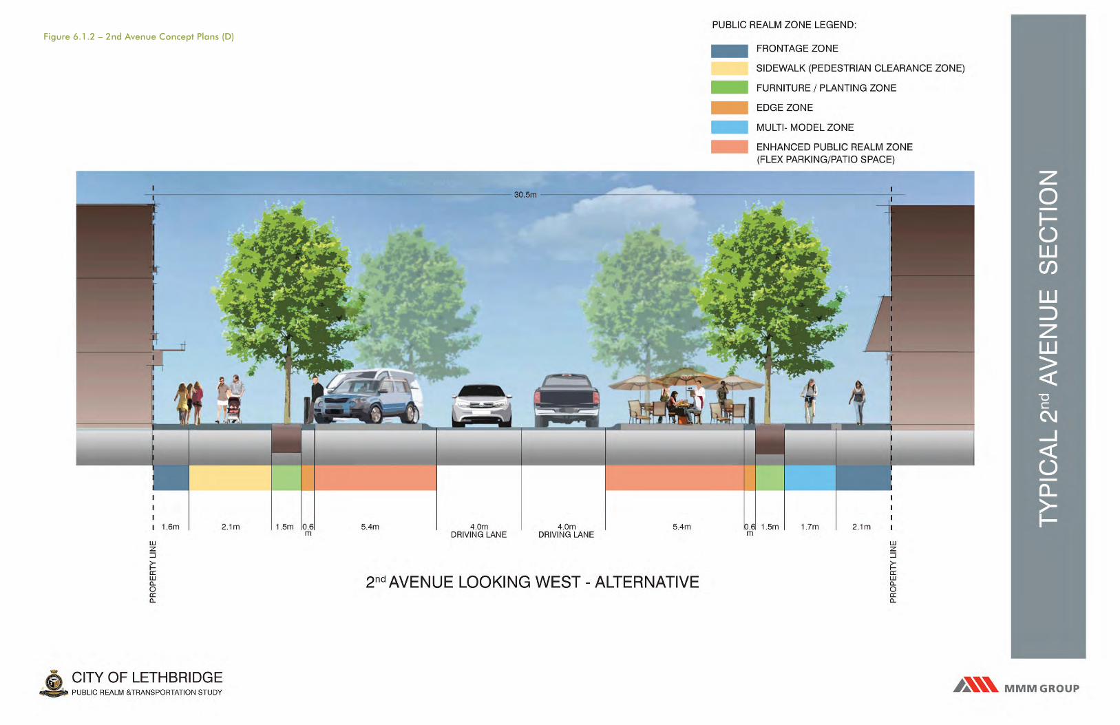
Figure 6.1.2 – 2nd Avenue Concept Plans (D)

CITY OF LETHBRIDGEPUBLIC REALM &TRANSPORTATION STUDY
2nd A
VE
NU
E T
RA
NS
ITIO
NA
L +
CH
INA
TOW
N
PU
BLI
C R
EA
LM Z
ON
E
SC
EN
IC D
RIV
E S
OU
TH
10 20 30 40 500
3RD S
TRE
ET
SO
UTH
CHINATOWN INTERPRETIVE AREA
CHINATOWN HERITAGE BUILDINGS
CASTLE APARTMENT COMPLEX
PUBLIC REALM ZONE LEGEND:
SIDEWALK (PEDESTRIAN CLEARANCE ZONE)
FURNITURE / PLANTING ZONE
ENHANCED PUBLIC REALM ZONE
(FLEX PARKING / PATIO PLAZA SPACE)
Figure 6.1.2 – 2nd Avenue Concept Plans (E)

CITY OF LETHBRIDGEPUBLIC REALM &TRANSPORTATION STUDY
2nd A
VE
NU
E T
RA
NS
ITIO
NA
L +
CH
INA
TOW
N
PU
BLI
C R
EA
LM Z
ON
E
PUBLIC REALM ZONE LEGEND:
SIDEWALK (PEDESTRIAN CLEARANCE ZONE)
FURNITURE / PLANTING ZONE
ENHANCED PUBLIC REALM ZONE
(FLEX PARKING / PATIO PLAZA SPACE)
10 20 30 40 500
4TH S
TRE
ET
SO
UTH
5TH S
TRE
ET
SO
UTH
2ND AVENUE PLAZA AND RAISE INTERSAECTION
FIRE STATION NO.1 PATIO
LETHBRIDGE HOTEL
LETHBRIDGE CHIROPRACTIC
FINE TUNED HOBBIES
GAULT GARDENS
Figure 6.1.2 – 2nd Avenue Concept Plans (F)
GALTGARDENS
ORIGINAL #1 FIRE HALL

Figure 6.1.2 – 2nd Avenue Concept Plans (G)

Figure 6.1.2 – 2nd Avenue Concept Plans (H)

Public Realm and TRansPoRTaTion sTudy foR downTown leThbRidge | mmm gRouP | febRuaRy 2012 | v 1.2 | 5210038000 130
2.0 3.0 4.0 5.0 6.0 7.0 8.01.0 2.0 3.0 4.0 5.0 6.0 7.0 8.01.0
6.1.3 3 AVENUE S ROADWAY DESIGN
3 Avenue S is a main collector into Downtown, on
which both the Southern Alberta Art Gallery (SAAG)
and the Lethbridge Community Arts Centre (LCAC)
are located. Given its prominence in use and cultural
amenities which front onto the street, this street is
proposed to have a unique ‘Civic’ character that reflects
the cultural importance of the area. Much like the
SAAG, this character is defined by the juxtaposition of
historic and contemporary styling. There already exists
ample historic styling in the existing buildings and
park elements. It is recommended that the treatment
of the public realm be contemporary character with
wide ‘promenade’ sidewalks with a high level of
pageantry associated with it.
Characteristic features of 3 Avenue S include:
» three travel lanes, with a middle turning bay
» rolled curb between travel lanes and parking
» parking raised to sidewalk level, allowing flexibility
of use for both pedestrian and vehicle use
» angled parking on the north side of the street in front
of Galt Gardens and the Lethbridge Community Arts
Centre
» parallel parking on the south (retail) side between 8
Street S and 5 Street S, and parallel parking on both
sides of the street west of 5 Street S
» street trees on both sides, spaced at +/- 15meters
on-centre
» pedestrian lighting spaced at +/- 15meters on-centre
» a wide sidewalk on both sides that will accommodate
both a Pedestrian Clearway and Frontage Zones
along existing retail land uses
» a wide Promenade sidewalk on the north, adjacent to
Galt Gardens between 5 and 8 Street S
(See pullout of 3 Avenue S Concept - Illustrative Plans
and Sections)

Figure 6.1.3 – 3rd Avenue Concept Plans (A)

CITY OF LETHBRIDGEPUBLIC REALM &TRANSPORTATION STUDY
3rd A
VE
NU
E IL
LUS
TRA
TIV
E P
LAN
10 20 30 40 500
GALT GARDENS
PERGOLA
EXPRESS COFFEE & TEA
LETHBRIDGECOMMUNITY ARTS
CENTRE
GALT GARDENSPERGOLA
LANGENBURGOPTICAL
LANGENBURGOPTICAL
METCALFEBLOCK
CASH CANADA
ROTARYCENTENNIAL
FOUNTAIN
SAAG
SAAG
EXISTING PUBLICART
EXISTING PUBLICART
EXISTING PUBLICART
EXISTING PUBLICART
EXISTING PUBLICART
PITA PIT SHANGHAICHOP SUEY
SHANGHAICHOP SUEY
DOVE CHRISTIANSUPPLIES
3rd AVENUE SOUTH 3rd AVENUE SOUTH
FESTIVAL SQUARE
FESTIVAL SQUARE
BACK ALLEY WALKWAY
3rd AVENUE SOUTH
SCOTIABANK THE SLICE BAR AND GRILL
FOSTERS JEWELERS
3rd AVENUE SOUTH
5TH S
TRE
ET S
OU
TH
4TH S
TRE
ET S
OU
TH
7TH S
TRE
ET S
OU
TH
8TH S
TRE
ET S
OU
TH
ROUND STREET SCRAMBLED
INTERSECTION
6TH STREET RAISED
INTERSECTION
6TH STREET RAISED
INTERSECTION
Figure 6.1.3 – 3rd Avenue Concept Plans (B)

Figure 6.1.3 – 3rd Avenue Concept Plans (C)

Figure 6.1.3 – 3rd Avenue Concept Plans (D)

CITY OF LETHBRIDGEPUBLIC REALM &TRANSPORTATION STUDY
3rd A
VE
NU
E T
RA
NS
ITIO
NA
L +
CO
NTE
MP
OR
AR
Y
PU
BLI
C R
EA
LM Z
ON
E
10 20 30 40 500
4TH S
TRE
ET
SO
UTH
5TH S
TRE
ET
SO
UTH
GAULT GARDENS
METCALFE BLOCK
EXPRESS COFFEE AND TEA
PUBLIC REALM ZONE LEGEND:
SIDEWALK (PEDESTRIAN CLEARANCE ZONE)
FURNITURE / PLANTING ZONE
ENHANCED PUBLIC REALM ZONE
(FLEX PARKING / PATIO PLAZA SPACE)
‘ROUND STREET’ SCRAMBLE
INTERSECTION
Figure 6.1.3 – 3rd Avenue Concept Plans (E)
GALT GARDENS

CITY OF LETHBRIDGEPUBLIC REALM &TRANSPORTATION STUDY
3rd A
VE
NU
E T
RA
NS
ITIO
NA
L +
CO
NTE
MP
OR
AR
Y
PU
BLI
C R
EA
LM Z
ON
E
10 20 30 40 500
8TH S
TRE
ET
SO
UTH
6TH S
TRE
ET
SO
UTH
8TH S
TRE
ET
SO
UTH
7TH S
TRE
ET
SO
UTH
PUBLIC REALM ZONE LEGEND:
SIDEWALK (PEDESTRIAN CLEARANCE ZONE)
FURNITURE / PLANTING ZONE
ENHANCED PUBLIC REALM ZONE
(FLEX PARKING / PATIO PLAZA SPACE)
GAULT GARDENS
SCOTIA BANKPITA PIT DOVE CHRISTIAN SUPPLIES
FESTIVALSQUARE
LETHBRIDGE COMMUNITY ARTS
CENTRE
Figure 6.1.3 – 3rd Avenue Concept Plans (F)
GALT GARDENS

CITY OF LETHBRIDGEPUBLIC REALM &TRANSPORTATION STUDY
3rd A
VE
NU
E L
AYO
UT
FESTIVAL SQUARE
10 20 30 40 500
4TH S
TRE
ET
SO
UTH
5TH S
TRE
ET
SO
UTH
LEGEND:
SITE FURNITURE
TREE GRATE AND STREET TREES
EXISTING STREET TREE
LIGHT
BANNER POLE
BOLLARD
TRASH RECEPTACLE
BENCH
SHELTER / BIKE STORAGE
WAYFINDING / TICKET DISPENSER
URBAN DESIGN
ELEMENT OF DISTINCTION
Figure 6.1.3 – 3rd Avenue Concept Plans (G)

CITY OF LETHBRIDGEPUBLIC REALM &TRANSPORTATION STUDY
3rd A
VE
NU
E L
AYO
UT
10 20 30 40 500
LEGEND:
SITE FURNITURE
TREE GRATE AND STREET TREES
EXISTING STREET TREE
LIGHT
BANNER POLE
BOLLARD
TRASH RECEPTACLE
BENCH
SHELTER / BIKE STORAGE
BUS STOP
WAYFINDING / TICKET DISPENSER
URBAN DESIGN
ELEMENT OF DISTINCTION
6TH S
TRE
ET
SO
UTH
8TH S
TRE
ET
SO
UTH
7TH S
TRE
ET
SO
UTH
FESTIVAL SQUARE
Figure 6.1.3 – 3rd Avenue Concept Plans (H)

Public Realm and TRansPoRTaTion sTudy foR downTown leThbRidge | mmm gRouP | febRuaRy 2012 | v 1.2 | 5210038000 139
2.0 3.0 4.0 5.0 6.0 7.0 8.01.0 2.0 3.0 4.0 5.0 6.0 7.0 8.01.0
6.1.4 ROADWAY DESIGN SUMMARY
The proposed roadway designs focus on modifications
made to existing curb lines which reduce the number
of vehicle travel lanes in order to provide more
streetscape opportunity; balancing the proportion of
public realm and vehicular realm without significant
loss of on-street parking.
Achieving a ‘balance’ is a key consideration and one in
which vehicle movement, vehicle parking, pedestrian
movement and active transportation needs to receive
equal attention.
Below is a comparison between on-street parking
spaces, using current conditions as a baseline, with the
number of parking spaces that were proposed in the
HOCMP recommendation and the number of parking
spaces proposed in the recommended Preliminary
Roadway Designs.
Table 6.1.4 – Parking Spaces Comparison
Selected Study Streets
Existing Parking Spaces
HOCMP Parking Spaces
Proposed Parking Spaces
5 street s
265 80 120
2 avenue s 117 42* 81
3 avenue s 90 38 80
Total spaces 472 160 281
Percentage % 100% 33% 60%
* based on hocmP Promenade Prototype option 1 (angled Parking configuration) Part 4, page 40
Based on the above summary, there would be a
reduction of on-street parking compared to current
conditions in order to achieve a higher level of public
realm articulation. However, the proposed Preliminary
Roadway Designs loss is significantly less (maintain
60% of existing parking) than what the HOCMP
recommends (maintain 33% of existing parking) based
on all parallel parking on Main Streets and Option 1
Angled Parking on Promenade Streets.
The provision of greater public realm space while
providing almost twice as much on-street parking
than the HOCMP is consistent with the overall public
realm objective as determined through the public
consultation process suggests:
“Create a balance between the public realm and the
traffic realm without a significant loss of on-street
parking, and enhance the overall quality of the
Downtown’s public realm for long term vitality and
promotion of the Downtown as a place to live and
work.”
6.2 PUBLIC REALM PRELIMINARY DESIGN COMPONENTS
The emphasis of the Public Realm and Transportation
Study is meant to be more than an exercise in ‘street
beautification’. It is meant to create more balance in
the public realm between the pedestrian and vehicle;
to increase pedestrian comfort through provision of
site amenities and increased planting; increased safety
by minimizing pedestrian/ vehicle conflicts, improve
sightlines and lighting; and to use Lethbridge’s
culture and heritage to create a unique identify for the
Downtown.
The public realm is made up of various components.
While the emphasis will be on quality of design and
achieving the larger public realm goals, consideration
to functionality, ease of implementation, ease of
maintenance and operations, as well as costing, will
also be important considerations. The following design
strategies and related drawings are meant to guide
future development of detail drawings and help to
coordinate the efforts in implementing the outlined
works:

Public Realm and TRansPoRTaTion sTudy foR downTown leThbRidge | mmm gRouP | febRuaRy 2012 | v 1.2 | 5210038000 140
2.0 3.0 4.0 5.0 6.0 7.0 8.01.0 2.0 3.0 4.0 5.0 6.0 7.0 8.01.0
6.2.1 INTERSECTIONS
PLAZA INTERSECTIONS
» Two (2) of the thirteen (13) intersections that comprise the study
area have been identified as Plaza Intersections and are typical of a
Promenade Streets terminating at Galt Gardens.
» Crosswalks would be raised and encompass the full width of the
intersection to reduce traffic speeds and promote pedestrian priority
crossing.
» They would be enhanced with special paving treatments (tinted
concrete) and pattern that will continue across the road bed to unify
both sides of the street and strengthen physical and visual connections
into the Park.
» Vehicular traffic lanes would be shifted to provide flexible parking/
festival event space.
» Plaza intersections are intended to be temporarily closed to vehicular
traffic on special event days.
» Provisions would be made for removable bollards to facilitate traffic
control.
» It is not recommended that unit pavers be used within the road bed due
to potential maintenance issues associated with snow clearing.
innovative use of urban space for Parking
same urban space used for festival events
illustrative Plan of 2nd avenue and 5th street s. Plaza intersection

Public Realm and TRansPoRTaTion sTudy foR downTown leThbRidge | mmm gRouP | febRuaRy 2012 | v 1.2 | 5210038000 141
2.0 3.0 4.0 5.0 6.0 7.0 8.01.0 2.0 3.0 4.0 5.0 6.0 7.0 8.01.0
SCRAMBLE CROSSWALK (PEDESTRIAN PRIORITY) INTERSECTIONS
Both the City of Toronto (Yonge/Dundas, Yonge/Bloor, and Bay/Bloor)
and the City of Calgary (3 St/ 2 Ave., 3 St/3 Ave. SW) have recently added
scrambled intersections at particularly busy streets with high pedestrian
and turning vehicle volumes.
The benefits of a Scrambled Intersection are to help eliminate conflicts
between pedestrians and turning vehicles and improve traffic flow
efficiency by reducing two directional pedestrian travel time. Features of
Scramble Crosswalk intersections include the following:
» Two (2) of the thirteen (13) intersections that comprise the study area
have been identified as potential Scramble Crosswalk Intersections and
are typical of ‘key pedestrian intersections’ within the Downtown.
» Crosswalks should be raised and encompass the full width of the
intersection to reduce traffic speeds and promote pedestrian priority
crossing.
» Crossings should be parallel to the roadway as well as diagonal with a
minimum 4.0m width.
» Enhanced with paving treatments (tinted concrete) and patterns would
be embedded into the road bed to unify both sides of the street and
provide strong visual cues for pedestrian flow.
» Traffic lights to provide a crossing phase for pedestrians only will be
required which will stop vehicular traffic and allow pedestrians to cross
in every direction, including diagonally, at the same time.
scramble intersection at yonge street and dundas, Toronto
enhanced streetscape and Roadway to create unified Public Realm, Penticton, bc
illustrative Plan of 3rd avenue and 5th street s. – scramble intersection

Public Realm and TRansPoRTaTion sTudy foR downTown leThbRidge | mmm gRouP | febRuaRy 2012 | v 1.2 | 5210038000 142
2.0 3.0 4.0 5.0 6.0 7.0 8.01.0 2.0 3.0 4.0 5.0 6.0 7.0 8.01.0
» It is not recommended that unit pavers be used within the road bed due
to potential maintenance issues associated with snow clearing.
» Informing the public is of key importance in implementing scramble
intersections because operational problems can arise, particularly with
the blind or visually impaired pedestrians. Many of these problems can
be overcome through media and public information sessions, the use
of appropriate signage and Accessible Pedestrian Signals (APS), and
increasing the cycle length of the timed crossing to accommodate longer
diagonal crossing times.
STANDARD INTERSECTION AND CROSSWALK
Standard intersections make up nine (9) of the thirteen (13) intersections
that comprise the study area and should have the following characteristics:
» Crossings parallel to a roadway have a crosswalk width of 3.0m to 4.0m.
» They are delineated through either painted lines, colour thermoplastic
over asphalt, or tinted stamped concrete embedded into the roadway.
» It is not recommended that unit pavers be used within the road bed due
to potential maintenance issues associated with snow clearing.
illustrative Plan of 5th avenue and 5th street s – standard intersection

Public Realm and TRansPoRTaTion sTudy foR downTown leThbRidge | mmm gRouP | febRuaRy 2012 | v 1.2 | 5210038000 143
2.0 3.0 4.0 5.0 6.0 7.0 8.01.0 2.0 3.0 4.0 5.0 6.0 7.0 8.01.0
6.2.2 MULTI-USE PARKING
The overall strategy toward on-street public parking is to provide a rolled curb at the
edge of the travel lanes and raise the vehicle parking spaces up to the sidewalk level.
Raised parking provides greater flexibility in how the critical street frontage area is
used, especially in commercial areas. Multi-use parking areas can be used for either
vehicle parking or extended public realm space such as outdoor patios. Such parking
areas could be of a duration suitable for the uses in the surrounding area.
Compensation for lost parking revenue will need to be determined by evaluating
current City practices. Options for consideration include: charges based on a short
term permit; or as part of annual property tax assessment for long term pedestrian
realm use. Based on City evaluations, current policies and practices may need to be
updated in order to make this type of parking strategy viable in the long term.
This strategy takes into account the dynamic nature of Downtown, such as how new
and infill development, as well as land tenure, can change over time. The strategy also
considers expanding the public realm by converting parking spaces into multi-purpose
spaces. This strategy will also help to support improvements in urban design.
The following are examples of proposed on-street parking typical dimensions based on
City of Lethbridge’s Land Use Bylaw 5700 and TAC best practice standards:
» Angle parking is the preferred form of on-street parking as it allows for a greater
number of parking spaces per linear meter of street frontage.
» Angle parking should be either on a 45° or 60° angle, 2.6m stall width, and a
minimum stall length of 5.8m.
Typical example of 45° angle Parking with 5.8m stall length (5.4m offset from curb line)

Public Realm and TRansPoRTaTion sTudy foR downTown leThbRidge | mmm gRouP | febRuaRy 2012 | v 1.2 | 5210038000 144
2.0 3.0 4.0 5.0 6.0 7.0 8.01.0 2.0 3.0 4.0 5.0 6.0 7.0 8.01.0
» Typical parallel parking should be 3.0m wide, with a minimal stall length of 7.3m long.
» Raised parking to sidewalk level provides barrier free access for users with limited
disability. This eliminates the need for extensive curb drop-downs
Typical Parallel Parking
Typical angle Parking – designated stall
» Typical designated on-street parking stalls for persons with physical disabilities should
be located closest to the intersection, or at ends of on-street parking bays so as to
incorporate adjacent public realm/ planting areas as refuge zones.
» Provide universal accessibility at all parking meters and ticket dispensers at a height of
1.0m.
Parking - Designated Stall
Concrete Sidewalk
Street / Pedestrian Light
Traffic Bollard / Banding
4.0m 2.0m
2.6m
1.5m 4.0-
4.4m
Desig
nate
d Sta
ll2.5-
2.9m
Adjacent Street
C.I.P. Concrete Roll Curb and Gutter
Area of Refuse
Planter
Typical Angled Parking with Surface Material as Identified in Report
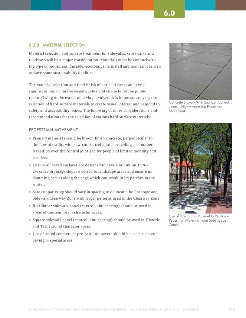
Public Realm and TRansPoRTaTion sTudy foR downTown leThbRidge | mmm gRouP | febRuaRy 2012 | v 1.2 | 5210038000 145
2.0 3.0 4.0 5.0 6.0 7.0 8.01.0 2.0 3.0 4.0 5.0 6.0 7.0 8.01.0
6.2.3 MATERIAL SELECTION
Material selection and surface treatment for sidewalks, crosswalks and
roadways will be a major consideration. Materials must be conducive to
the type of movement, durable, economical to install and maintain, as well
as have some sustainability qualities.
The material selection and final finish of hard surfaces can have a
significant impact on the visual quality and character of the public
realm. Owing to the extent of paving involved, it is important to vary the
selection of hard surface materials to create visual interest and respond to
safety and accessibility issues. The following outlines considerations and
recommendations for the selection of various hard surface materials:
PEDESTRIAN MOVEMENT
» Primary material should be broom finish concrete, perpendicular to
the flow of traffic, with saw-cut control joints; providing a smoother
transition over the control joint gap for people of limited mobility and
strollers.
» Ensure all paved surfaces are designed to have a minimum 1.5% -
2% cross-drainage slopes directed to landscape areas and ensure no
damming occurs along the edge which can result in icy patches in the
winter.
» Saw-cut pattering should vary in spacing to delineate the Frontage and
Sidewalk Clearway Zone with larger patterns used in the Clearway Zone.
» Rectilinear sidewalk panel (control joint spacing) should be used in
areas of Contemporary character areas.
» Square sidewalk panel (control joint spacing) should be used in Historic
and Transitional character areas.
» Use of tinted concrete or pre-cast unit pavers should be used as accent
paving in special areas.
concrete sidwalk with saw cut control Joints – highly accesible Pedestrian movement
use of Paving and material to Reinforce Pedestrian movement and streetscape Zones

Public Realm and TRansPoRTaTion sTudy foR downTown leThbRidge | mmm gRouP | febRuaRy 2012 | v 1.2 | 5210038000 146
2.0 3.0 4.0 5.0 6.0 7.0 8.01.0 2.0 3.0 4.0 5.0 6.0 7.0 8.01.0
MULTI-MODAL MOVEMENT
» The preferred material is broom finish concrete, perpendicular to
the flow of traffic, with saw-cut control joints; providing a smoother
transition over the control joint gap for cyclists.
» Should ensure all paved surfaces are designed to have a a minimum
1.5% - 2% cross-drainage slopes directed to curb edge and ensure no
damming occurs along the edge which can result in icy patches in the
winter.
» A cost effective option is hot-mix asphalt concrete paving (asphalt). If
Asphalt is to be used, an Upper Course #2 Mix (max 12.5mm aggregate
size) is to be specified. Minimum cross-drainage slope to be 2%.
» Any asphalt paving used in the public realm should be retained by a
concrete edge; rolled curb, sidewalk slab, concrete band.
PARKING
» The preferred material for on-street parking is precast concrete unit
pavers. Paver type, size and colour can change to reflect the different
public realm character; Historic, Transitional, Contemporary.
» Precast unit Pavers paving should be 80mm thick, rated to accept
vehicle loading, and placed on an appropriate base material as
determined by a Geotechnical Engineer.
» An interlocking paver pattern, such as Herringbone, should be used in
traffic areas where precast unit pavers are used
» A cost effective option is hot-mix asphalt concrete paving (asphalt).
If Asphalt is to be used, it is to match the City of Lethbridge Design
Standards, latest edition.
» Use of specially design paver units, such as AquaPave®, can be used
for permeable on-site stormwater control to reduce excess stormwater
runoff quantities and improve stormwater quality (see Sustainable
Streetscape Strategies).
example of multi-modal way – separation and surface Treatment
Rasied Parking used successfully, downtown victoria, bc

Public Realm and TRansPoRTaTion sTudy foR downTown leThbRidge | mmm gRouP | febRuaRy 2012 | v 1.2 | 5210038000 147
2.0 3.0 4.0 5.0 6.0 7.0 8.01.0 2.0 3.0 4.0 5.0 6.0 7.0 8.01.0
COLOUR PALETTE
Colour can have a significant impact on the visual
quality and character of the public realm. The use of
colour can add distinction to the streetscape, can unify
a variety of different elements, and help in wayfinding.
Design solutions should avoid the use of too many
different colours. There is a tendency for to create
visual dis-harmony with too many competing colours.
The following identifies opportunities to introduce the
strategic use of colour into the public realm:
» Standard powder-coated colour for all site furnishing
such as benches, trash receptacles, light bases and
poles should be black. This will help unify various
public realm elements whether existing or proposed.
•Black is readily available as a standard colour, it is
considered a ‘classic colour; which is not subject
to stylistic changes, therefore is complimentary to
large number of other materials
» Custom colours for site furnishing can be used
for elements of distinction, but generally have a
cost premium attached. A representative palette
of custom colours has been developed (see Figure
6.2.3).
» Planting of vegetation can be used to introduce
colour, and as a way to celebrate the change of
seasons.
» Annual plantings, such as in raised planters and
hanging baskets, can provide an opportunity to
introduce a colour and vibrancy to the street in a
relatively inexpensive way.
» Nylon banner art can be colourful as well help to
advertise community festivals and events.
Figure 6.2.3 - Custom Colours Palette Reflects the Natural Landscape

Public Realm and TRansPoRTaTion sTudy foR downTown leThbRidge | mmm gRouP | febRuaRy 2012 | v 1.2 | 5210038000 148
2.0 3.0 4.0 5.0 6.0 7.0 8.01.0 2.0 3.0 4.0 5.0 6.0 7.0 8.01.0
MAINTENANCE
Operations and maintenance can play an important
role in the selection of materials. The extent of
pedestrian infrastructure that is associated with
Downtown Lethbridge represents a considerable
investment and commitment of public resources.
The following are maintenance considerations when
selecting materials:
» Select materials that are durable, easy to maintain
and, if necessary, can be replaced without creating a
visible difference between the old and new.
» Highly decorative patterns and colour finishes are
difficult to match when patching. If such features
are to be added, incorporate logical breakout areas
into the design, so larger sections can be replaced in
order to make repairs less noticeable.
» Coordinate selection of paving material with surface
operations (‘Clean-Sweep’ program), especially for
snow removal equipment. Hand sweeping or power
brooms are recommended for snow removal on
precast concrete unit pavers.
» Minimize material changes that require different
base and sub-base preparations which can result
in differential settlement; resulting in drainage
problems and tripping hazards.
» Owing to Lethbridge’s Chinooks and winter freeze-
thaw cycles, ensure there are adequate cross-
drainage slopes on pavement surfaces, and water is
directed to systems that will collect and drain water
away quickly to avoid icing. Provide catch basins and
area drains in isolated areas, if required.
» Develop a street tree maintenance program in
conjunction with the City Arborist, including
removal of dead branches, pruning to thin and
shape tree canopy, and soil testing and nutrient
replenishment.
» Provide a high efficiency underground automatic
irrigation system for street planting that is connected
to a centralized controller and monitoring station;
allowing for greater ease and efficiency in watering.
» Encourage ‘civic pride’ in the public realm by being
proactive in maintenance, especially with regard
to surface condition, trash pick-up, and vandalism
(including graffiti). Develop partnerships with
private sector property and business owners, the
Downtown BRZ and ‘Hotline’ to quickly respond to
maintenance, security issues and emergency repairs.
» Together with other City departments, develop an
anti-graffiti ‘wrap program where utility boxes are
wrapped in vinyl photos and images. The vinyl photo
wraps can withstand temperatures from –54 to +107
C. The artwork makes it more difficult to see any
graffiti and the vinyl surface allows for an easy clean
up if the boxes are tagged. This program has been
extremely successful in other Canadian cities such as
Kelowna.
6.2.4 UNIVERSAL ACCESSIBILITY
The intent is to design and construct a public realm
that people, of all ages and physical abilities can use
and enjoy equally. Barrier-Free Design is based on
established safety codes and design standards (such
as those set out by the Alberta Safety Code Council)
that promotes proper and safe access - especially for
seniors and people with disabilities. Urban Braille is
an example of design standards and details which can
be incorporated into the public realm that specifically
address people with limited vision or are visually
impared. Principles of ‘Barrier-free Design’ and ‘Urban
Braille’ have been incorporated into the preliminary
designs, and include the following:

Public Realm and TRansPoRTaTion sTudy foR downTown leThbRidge | mmm gRouP | febRuaRy 2012 | v 1.2 | 5210038000 149
2.0 3.0 4.0 5.0 6.0 7.0 8.01.0 2.0 3.0 4.0 5.0 6.0 7.0 8.01.0
BARRIER-FREE DESIGN
» A consistent sidewalk width (Clearway Zone) that is free of obstructions
should be provided in a clear path of travel that will continue through to
crosswalks.
» Primary pathway surface should be cast-in-place concrete with saw-cut
control joints to provide a smooth walking surface, free of abrupt edges
that will create potential tripping hazards and make it difficult for wheel
chair and strollers movement.
» Raising crosswalks to sidewalk level at key intersections will give priority
to pedestrians.
» Where intersections are not raised, separate curb let-downs should be
provided for each parallel crosswalk.
» Traffic bollards to protect pedestrians waiting to cross from turning
vehicles should be provided. Maintain incline gradients of pathway
between a minimum of 1% to a maximum of 5% (optimal for cycling and
walking).
» Manholes and other service features should be minimized or relocated
where they won’t cause tripping hazards.
» Incorporating high contrasting colours with legible signage and symbols
of sufficient size should be part of a wayfinding strategy.
URBAN BRAILLE
Suggestions that incorporate Urban Braille elements include the following:
» Incorporating ‘Advanced Warning Strips’ prior to intersections,
consisting of a double row of soldier course pavers perpendicular to the
direction of movement.
» Providing a single row of soldier course ‘shoreline pavers’ that are of a
high-contrasting colour to the paving field in order to delineate the area
of potential traffic conflicts at intersections.
» Incorporating tactile guides into paving at ‘sidewalk zones’ leading
to curb letdowns. Guides can be either a series of grooved reveals in
concrete or a textured paving band.
» Providing verbal or audible APS at intersections that operate on a 24/7
basis and adjust to ambient sound levels.
Raised intersection with Traffic bollards – Promotes Pedestrian Priority and accessibility
urban braille Treatment with high contrasting Pavers and Tactile changes at intersection

Public Realm and TRansPoRTaTion sTudy foR downTown leThbRidge | mmm gRouP | febRuaRy 2012 | v 1.2 | 5210038000 150
2.0 3.0 4.0 5.0 6.0 7.0 8.01.0 2.0 3.0 4.0 5.0 6.0 7.0 8.01.0
CRIME PREVENTION THROUGH ENVIRONMENTAL DESIGN PRINCIPLES
CPTED is a holistic approach that balances the
objectives of reduction in crime with the elements of
good design to create attractive public environments.
The full extent of CPTED principles is beyond the
scope of this project. However, pertinent urban design
and streetscape principles that may be the focus of
further study during detail design include:
» creating natural surveillance and sight lines to
ensure unobstructed views between 0.6 meter height
and 1.5 meter height
» providing pedestrian level lighting at a lux/
footcandle level sufficient enough to uniformly light
adjacent sidewalk in order to meet ‘High Pedestrian
Conflict’ illumination classification. Levels of 12 lux/
1.2 footcandles with an average uniformity of 4:1 are
recommended for major pathways
» improving safety through participation and use
» creating a sense of ownership
» encouraging territorial reinforcement in Frontage/
Market Streetscape Zone
6.2.5 PLANTING
As one of the HOCMP Pillars, planting in Downtown
will bring many social, economic and environmental
benefits as well as contribute to the public realm.
We respond positively to the presence of street trees
because of their beauty and the shade that they
provide. They also help in improving air quality, lower
building energy needs in the summer, buffer wind,
increase property values, and can supplement passive
stormwater management system through the up-take
of water. Trees are able to provide all these benefits
at a relatively low cost. To ensure trees reach their
maximum potential and benefits in a harsh urban
environment, the following will need to be considered
early in the design process, and evaluated with current
City practices in order to make any necessary policy
changes:
PLANT SPECIES SELECTION
The following should be considered when selecting
plant species:
» Select the right tree for the right space. Tree
species need to be tolerant of urban conditions that
they are placed in. If salt is to be used as part of
surface operation and snow removal practices, salt
Tree species used to create diversity and seasonal colour

Public Realm and TRansPoRTaTion sTudy foR downTown leThbRidge | mmm gRouP | febRuaRy 2012 | v 1.2 | 5210038000 151
2.0 3.0 4.0 5.0 6.0 7.0 8.01.0 2.0 3.0 4.0 5.0 6.0 7.0 8.01.0
tolerant species such as Green Ash (Fraxinus pennsylvanica) should be
considered.
» Select tree species, as possible, based on a maximum mature growth
area of 8.0m width and 15m height.
» Select tree species that are identified in the City of Lethbridge’s
Construction Specification Section 07020; Small, Medium and Large
street tree lists.
» Avoid use of monocultures (single tree species) to promote bio-diversity
and avoid catastrophic loss due to disease and pest infestation.
» If a single species is to be used, a strong pest and disease management
strategy needs to be developed as part of a maintenance program.
» Use of native and native-adaptive planting that is drought tolerant will
reduce water irrigation requirements. It should be noted that during the
critical one to two year establishment period increased irrigation times,
compared to typical species requirements, are recommended.
» Select low shrub, ornamental grass and perennial plant species
(maximum 0.45m height) to preserve visual sightlines, especially at
intersections.
» Select hardy drought tolerant shrub, ornamental grass and perennial
plant species that are able to tolerate high user conflicts without
impacting growth form. Ornamental grasses are ideal planting in
urban streetscape environments owing to the variety of species, growth
characteristics and ability for damaged vegetation to quickly grow back.
ornamental grasses add colour and distinctiveness while being highly Tolerant of urban conditions

Public Realm and TRansPoRTaTion sTudy foR downTown leThbRidge | mmm gRouP | febRuaRy 2012 | v 1.2 | 5210038000 152
2.0 3.0 4.0 5.0 6.0 7.0 8.01.0 2.0 3.0 4.0 5.0 6.0 7.0 8.01.0
STREET TREE IMPLEMENTATION STRATEGIES
» Maximize available soil volume to maximize tree canopy and tree vigor.
Tree growth is restricted by its root growth. If poor soils or low soil
volumes are provided, such as in urban environments, tree size and
health will be restricted. Best practices suggest a minimum 36 cu.m of
soil volume per large tree.
» Use of ‘suspended paving systems’ such as Silva-Cell® technology to
support paving while providing necessary soil volumes for trees (see
Sustainable Streetscape Strategies).
» Reduce specified compaction rates of sub grade in critical 0.6m – 0.9m
root depth to 75% Standard Proctor Density.
» Scarify existing subgrade soils prior to placing new soils to improve
drainage.
» Minimize Conflicts with underground infrastructure and provide root-
deflecting devices, such as DeepRoot® root barriers, adjacent to paving
and utilities.
increased soil volume equals increased urban Tree health, vigour and size
strategic location of shallow utilities and use of Root barriers help to Reduce street Tree conflicts in urbanareas

Public Realm and TRansPoRTaTion sTudy foR downTown leThbRidge | mmm gRouP | febRuaRy 2012 | v 1.2 | 5210038000 153
2.0 3.0 4.0 5.0 6.0 7.0 8.01.0 2.0 3.0 4.0 5.0 6.0 7.0 8.01.0
» Tree grates are beneficial in urban environments
where compaction is an issue, they do however have
maintenance issues with accumulation of garbage
and debris. Over time it should be anticipated that
tree grates will be removed once the trunk flare
starts to reach maximum tree grate openings.
» Design for future root and trunk growth (removable
or break away tree grate system).
» The best option for tree staking is the ‘no-staking’
option. Staking in an urban environment can create
user conflicts due to lack of space around the tree
and care needs to be taken that any staking does not
penetrate the rootball system. It is also important
that any guy wires holding the tree are removed after
the root system is established, and before the tree is
girdled by the tie-backs.
» Owing to the wind conditions that Lethbridge is
noted for, some form of temporary tree staking may
be required. This will need to be evaluated at a detail
design level and appropriately detailed. One solution
is to provide a tree guard that will also be used as
an anchor for nylon strapping such as ArborTie® by
DeepRoot.
TREE AND PLANTING MAINTENANCE
The following tree and planting maintenance
requirements will need to be considered early in
the design process, and evaluated with current City
practices in order to make any necessary policy
changes:
» Develop landscape maintenance guidelines and
manuals based on short-term establishment and
long-term maintenance programs.
» Establish a regular tree monitoring and pruning
program and specifications to identify tree health
issues earlier rather than later.
» Establish an annual testing and fertilization program
and specifications to replenish soils.
» Establish a pest and disease monitoring and
management program.
6.2.6 IRRIGATION
COMPONENT SELECTION CRITERIA AND WATER SOURCE SUPPLY
The following should be considered for the selection of
water source supply:
» Irrigation systems should be engineered for high
water usage efficiency.
» Components should comply with City of Lethbridge,
local and international common standards to
guarantee a continued components service, upgrades
and renovation as required.
» More than likely the source of irrigation water will
be from the Municipal domestic water service due
to the proximity of existing infrastructure, ease of
connection, and reliability of a constant source of
a water at a constant quality. However, this should
not preclude investigation, at a detail design level,
into alternate sources of water for irrigation such
as: groundwater, grey water, stormwater capture
from adjacent buildings, and treated effluent water
(T.E.W).
» Irrigation components should be selected that are
compatible to the water supply source and colour
code irrigation components based on this supply (i.e.
Use purple colour components for T.E.W).
» Water application rates should be quantified and
qualified, flow rates and schedules should be based
on landscape material peak demand to ensure
adequate availability and water source capacity.
DESIGN CRITERIA
Best practice indicates that the following attributes
would create a desired watering system:
» components selected for longest life-cycle durability
» configuration designed for modular installation

Public Realm and TRansPoRTaTion sTudy foR downTown leThbRidge | mmm gRouP | febRuaRy 2012 | v 1.2 | 5210038000 154
2.0 3.0 4.0 5.0 6.0 7.0 8.01.0 2.0 3.0 4.0 5.0 6.0 7.0 8.01.0
» sub-surface installation with a minimal foot print
above ground
» consider using solar power supplies as part of
Sustainability considerations
» provide irrigation components that allow for
supplemental manual watering
OPERATIONS AND MAINTENANCE
Suggestions that would improve operations and
maintenance include:
» allowing for Irrigation Central Controls Systems
(ICC) and remote monitoring and management
» providing a two-way communication to and from the
site to optimize system operation
» employing weather or soil moisture factors to
optimize the irrigation operation
» establishing flow monitoring and management
capabilities to minimize or eliminate problem
» employing low-power, wireless sensor networks to
reduce operating energy costs
6.2.7 SITE FURNISHING
Site furnishings can cover a wide range of site
amenities, such as benches, trash receptacles, bike
racks, bike shelters, kiosks, wayfinding and banner
poles. The goal is to harmonize their selection (design),
scale and location to create a pleasant, unified, clutter-
free, safe, low maintenance, and pedestrian oriented
environment.
A representative selection of common site furniture
elements has been developed to correspond with
the different streetscape characters of: Historical,
Transitional, and Contemporary (see Kit of Parts). In
addition to selecting the correct style, the following
criteria should also be considered:
BENCHES
» Bench seating should be selected to coordinate
with other site furnishings, in terms of character,
materials, and colour - preferably selected from a
‘family of elements’ from the same manufacturer
in order to create an aesthetically appealing public
realm (see Kit of Parts).
» Bench seating should face the principal pedestrian
routes, and locations coordinated with planting
areas within the public realm to ensure maximum
visual interest and vegetated relief to street traffic.
» Bench selection should be a minimum of 1.8 metres
in length and have a center arm to discourage users
from lying on the bench. As an alternative individual
seating could be considered. Back support should be
provided for user comfort.
» Benches should be manufactured using high quality
materials and fabrication methods in order to reduce
maintenance requirements.
» Benches should be manufactured using
environmentally sustainable practices and
materials, be vandal resistant and, if possible, locally
manufactured for ease of replacement of parts.
» Benches should be surface mounted on concrete
sidewalks or pads. In paving areas that use pre-cast
concrete pavers, threaded rods should be set into
concrete below the paver surface for mounting.
» Adequate leg room in front of the bench to avoid
user conflicts should be ensured.
benches encourage Pedestrian use and comfort

Public Realm and TRansPoRTaTion sTudy foR downTown leThbRidge | mmm gRouP | febRuaRy 2012 | v 1.2 | 5210038000 155
2.0 3.0 4.0 5.0 6.0 7.0 8.01.0 2.0 3.0 4.0 5.0 6.0 7.0 8.01.0
TRASH RECEPTACLES/ RECYCLING
» Waste receptacles should be selected to coordinate with other site
furnishings, in terms of character, materials, and colour - preferably
selected from a ‘family of elements’ from the same manufacturer in
order to create an aesthetically appealing public realm (see Kit of Parts).
» Waste receptacles should be located in close proximity, but not adjacent
to, bench locations to avoid odour nuisances and to be located outside of
the primary flow of pedestrian and cycle traffic.
» Final selection of all trash cans must be approved by City of Lethbridge
Parks Operations at the detail design level.
At this time, a recycling program has not been identified by the City of
Lethbridge as a requirement applicable to the public realm design for the
selected study streets. However, given the precedence of the study, length
of streetscape involved, and level of public environmental awareness, there
is a great opportunity for implementing a recyling program as part of the
Clean Sweep Program that already exists.
» Further study into the possible use of recycling containers should be part
of the detailed design development, with City input on the feasibility and
timing of this program.
BOLLARDS
» Traffic Bollards should be selected to coordinate with other site
furnishings, in terms of character, materials, and colour - preferably
selected from a ‘family of elements’ from the same manufacturer in
order to create an aesthetically appealing public realm (see Kit of Parts).
» Traffic Bollards should be used at points of conflict between pedestrian
and vehicular traffic. Typical locations include at major (4-way)
intersections, and in the edge zone between raised on-street parking
stalls and pedestrian circulation.
» A cast-in-place concrete base should be provided at traffic bollard
locations for reinforced mounting.
simple elegant Trash Receptacle by victor stanley
bollards add to character of the Public Realm

Public Realm and TRansPoRTaTion sTudy foR downTown leThbRidge | mmm gRouP | febRuaRy 2012 | v 1.2 | 5210038000 156
2.0 3.0 4.0 5.0 6.0 7.0 8.01.0 2.0 3.0 4.0 5.0 6.0 7.0 8.01.0
BIKE RACKS, SHELTERS AND LOCKERS
» In order to promote biking as an alternative mode of transportation,
facilities for securing bikes need to be provided. Bike parking can allow
for a single bike, multiple bikes, or allow for the storage of both bikes
and belonging for longer stays.
» Bike parking does take up space within the public realm owing to the
length of a bike (1.80m). Placement of various bike amenities needs
to be part of a larger overall Downtown bike facility strategy to avoid
wasteful space and costs.
» Individual bike parking takes up less space and should be part of a larger
strategy of placing bike racks at regular intervals along public realm for
short duration stays.
» Bike racks should be selected to coordinate with other site furnishings,
in terms of character, materials, and colour - preferably selected from a
‘family of elements’ from the same manufacturer in order to create an
aesthetically appealing public realm (see Kit of Parts).
» Bike shelters (with bike parking corrals) take up considerably more
space than individual racks, therefore their use and placement needs
to be more centralized and complementary to major destinations and
attractions within the Downtown and should be well lit and signed.
» Owing to the area required for bike shelters, locations should not impede
pedestrian circulation and should not interfere with major sightlines.
It is recommended that bike shelters are located close to major
intersections and within the expanded public realm zones or within
vehicle parking stalls claimed by the City for the purpose of bike parking.
» Storage lockers allow for more security for cyclists in leaving their
bikes and possessions for longer duration stays. Storage lockers can be
either freestanding elements within the public realm, or incorporated
into vehicle parkade structures. The latter is the preferred option
due to efficiency and economy of means, as well as the physical area
involved. Bike lockers could be rented or leased, therefore would require
administration.
» Bike shelters provide more protection from the weather owing to the
covered roof. The roof structure provides an opportunity to incorporate
slight stylistic changes and should be designed or selected to fit with
established character zones (see Kit of Parts).
covered bike storage with signage and wayfinding
simple elegant bike Rack by maglin

Public Realm and TRansPoRTaTion sTudy foR downTown leThbRidge | mmm gRouP | febRuaRy 2012 | v 1.2 | 5210038000 157
2.0 3.0 4.0 5.0 6.0 7.0 8.01.0 2.0 3.0 4.0 5.0 6.0 7.0 8.01.0
» Freestanding storage lockers for cyclists should be provided at Galt
Gardens, and other major destination points within the Downtown.
» Catalogue specified storage lockers are utilitarian in nature, lacking
any visual character. Where possible, such as in Galt Gardens, bike
lockers should be incorportated into existing architectural styling or
public realm themes through the use of customized structures (i.e.
pergola) or anti-graffitti vinyl photos wrap programs (see Section 6.2.3 -
Maintenance).
STREETSCAPE PAGEANTRY
The use of banner poles and nylon banners are an easy and effective way
to annimate the streetscape. In order to impletment this strategy the Ctiy
will need to update their regulatory environment. If implemented the
following are potential benefits:
» Two-dimensional art works, in the form of banners attached to
pedestrian light poles, provide an effective method of ‘place-making’.
» Banners can be dye-printed on transparent nylon, which allows light to
pass through and creates an illuminated effect.
» Streetscape pageantry can be an easy and cost effective method to
introduce colour and images from the City or Community to advertise
upcoming events and create vibrancy for in the Downtown.
» There are a number of festivals and events that are specific to the City of
Lethbridge (i.e. Whoop-Up Days) which has great potential for a street
banner program.
» Other themes for future exploration include: Art and Culture (in support
of the SAAG and Galt Museum); food and shop (in support of area
merchants); building heritage (to bring awareness to the Lethbridge’s
architectural diversity in the Downtown).
» Railway Heritage (the role CPR played in opening the west) is another
possible theme.
Pageantry banners used to advertise civic events

Public Realm and TRansPoRTaTion sTudy foR downTown leThbRidge | mmm gRouP | febRuaRy 2012 | v 1.2 | 5210038000 158
2.0 3.0 4.0 5.0 6.0 7.0 8.01.0 2.0 3.0 4.0 5.0 6.0 7.0 8.01.0
WAYFINDING
Wayfinding is intended to both enhance the visual quality of the public
realm as well as guide users to and from their destinations, through
easy-to-understand, attractive signage systems. It principally assists
pedestrians to orient themselves and navigate to key destinations within
walking distance. This system can be developed in concert with any
Streetscape Pageantry proposed.
The selected graphic layout of wayfinding for Downtown should be
distinctive for the Downtown area yet maintain a level of consistency and
cohessivness with the City-wide wayfinding strategy.
Due to the number of key civic and institutional facilities within
Lethbridge’s Downtown, it is suggested that a strategic wayfinding
program be developed to direct people to the following key destinations:
» Galt Gardens and the Southern Alberta Art Gallery
» The Galt Museum
» Chinatown District
» City Hall
» University of Lethbridge Downtown Building
» Lethbridge Community and Performing Art Centre (when completed)
» Major shopping and eating district such as Park Place Mall and
Lethbridge Centre
» Incorporate wayfinding signage with transit shelters and bike parking
facilities
» Public washroom in the Galt Gardens
wayfinding Kiosk also used for herigate interpretation

Public Realm and TRansPoRTaTion sTudy foR downTown leThbRidge | mmm gRouP | febRuaRy 2012 | v 1.2 | 5210038000 159
2.0 3.0 4.0 5.0 6.0 7.0 8.01.0 2.0 3.0 4.0 5.0 6.0 7.0 8.01.0
URBAN DESIGN
Urban Design is best used in situations where smaller gestures of
uniqueness within the public realm are required, which do not warrant a
more a formal public art process.
» The use of urban design elements within the public realm provides an
opportunity to create features of distinction that attract, engage and can
educate the user.
» Urban Design is typically undertaken at the detail design level, where
cultural or regionally specific details are incorporated into the design of
streetscape elements (i.e. a bridge trestle and girder detail used in the
structure of a bike or transit shelter).
» Opportunities for Urban Design explored at a detailed design level
include: incorporation of details from iconic landmarks such as the
High-Level Bridge; railway details; agricultural details; historic maps
embedded into pavement surfaces; special lighting or custom fixtures;
custom benches and seating; cultural and historical imagery for anti-
graffiti wraps.
6.2.8 LIGHTING
Lighting is the primary method to ensure pedestrians feel safe and secure
at night by increasing visibility. Adequate lighting is essential in the
Downtown to encourage pedestrian activity after business hours, and in
promoting a more liveable Downtown.
The main objective of pedestrian lighting is to increase the watching
opportunities, or ‘eyes on the street’, and set the tone for beautifying or
enhancing the pedestrian environment through appropriate selection of
fixtures. Lights also need to be selected to minimize glare and excessive
light pollution in order to preserve the evening dark sky.
Currently a variety of different types of light fixtures exist in the
Downtown. The Cobra street light is the most common, but lacks the
appropriate aesthetic and pedestrian scale. Existing globe lights, while
having the appropriate scale, lack the ability to control the illumination
pattern; creating excessive glare.
Transit shelters add to character of Public Realm
urban design and gateway element made from steel Trusses
example of steel Trusses used for lethbridge’s cPR high level bridge

Public Realm and TRansPoRTaTion sTudy foR downTown leThbRidge | mmm gRouP | febRuaRy 2012 | v 1.2 | 5210038000 160
2.0 3.0 4.0 5.0 6.0 7.0 8.01.0 2.0 3.0 4.0 5.0 6.0 7.0 8.01.0
New pedestrian and street lighting is proposed for Lethbridge’s public
realm. Lighting characteristic that should be considered include:
» Street lights of 10.0m in height or more should be complimentary to
pedestrian lights (see Kit of Parts) including pole, base and colour in
order to create unified and aesthetically appealing public realm.
» Street lights should accommodate, by means of a davit arm assembly,
pedestrian scale fixtures at 6.0m height.
» Preliminary plans identify street lights at a maximum spacing of 30.0
meters on-centre to coincide with street tree planting and pedestrian
lights. Adaptation methods, such as the utilization of existing street
lights, should be considered with regards to any existing street lights
that are within the edge zone.
» Pedestrian lights should be a minimum of 6.0m in height to
accommodate banner arms. If hanging baskets are considered,
provisions should be made to allow for irrigation lines to be incorporated
into the poles to avoid exposing irrigation lines.
» It is recommended that the City of Lethbridge evaluate the use of
Light-Emitting Diode (LED) as a lamp option for outdoor street and
pedestrian lighting. LED lights are more energy efficient and offer longer
service-life, resulting in savings in energy and maintenance. LED is
more expensive and performance is largely dependant on the ambient
temperature of the operating environment.
» Preliminary plans identify pedestrian lights at a maximum spacing of
15.0 meters on-centre to coincide with street tree planting and street
lights.
» Special lighting for the Chinatown District should be considered as part
of urban design and elements of distinction.
» Pedestrian lighting should have a lux/ footcandle level sufficient
enough to uniformly light adjacent sidewalk in order to meet ‘High
Pedestrian Conflict’ illumination classification levels as recommended to
accomplish Crime Prevention Through Environmental Design (CPTED).
» Weather-proof outdoor receptacles allow for easy access to power for
special event lighting such as Christmas street lighting. Ideally these
receptacles should be located in the street light poles and are optional to
most light and pole manufacturers.
» The use of string lighting for street trees is discouraged, as the wiring
and electrical supply conduits conflict with the tree root system and will
eventually girdle and strangle the tree.
Pedestrian lighting to Provide uniformly lit Pathway, while Preserving evening skies
example of distinctive lighitng used in chinatown district

Public Realm and TRansPoRTaTion sTudy foR downTown leThbRidge | mmm gRouP | febRuaRy 2012 | v 1.2 | 5210038000 161
2.0 3.0 4.0 5.0 6.0 7.0 8.01.0 2.0 3.0 4.0 5.0 6.0 7.0 8.01.0
6.2.9 SUSTAINABLE STREETSCAPE STRATEGIES
The need for a higher level of sustainability is outlines earlier in
Section 5.8, which used the City of Lethbridge’s Integrated Community
Sustainability Plan/Municipal Development Plan (ICSP/MDP) as its
basis. Many of these strategies incorporate new construction methods,
technologies and materials. As with any new system, there is a cost
premium connected to them. These higher costs are typically associated
with material supply and installation costs, and when viewed in the
context of long term reduction of natural resources, maintenance and
operation costs (life-cycle costing) can become more economically feasible.
The following are examples of sustainable streetscape strategies directly
applicable to the public realm and should be considered during detail
design:
» Planted bio-infiltration areas can be used to capture run-off from
the sidewalks and parking surfaces, thus minimizing the stormwater
impacts and need to upgrade existing infrastructure network.
» In addition to stormwater detention, the plants and soils will help filter
suspended solids and contaminants from the water before it eventually
returns to groundwater. A geotechnical report and review of soil
requirements would be required to determine the retention capabilities
of existing soils.
» For LEED projects, it is required that the site use high albedo paving for
50% of hard surface areas with a Solar Reflectance Index (SFI) of 0.30
or greater, to match LEED® requirements for Sustainable Site credit 7.1
Heat Island Effect Non-Roof (SSc 7.1).
» Permeable On-Site Stormwater Source Control Systems, such as
AquaPave®, combines the parking, infiltration and detention facilities
into one location. Benefits include the reduction of runoff directly
entering and taxing the municipal storm system, intercepting and
filtering of pollutants such as oil contaminates and asbestos from brake
pads, and recharging of the groundwater table.
» AquaPave® has life-cycle cost benefit that can out-way the initial
installation cost premiums and semi-annual maintenance and has been
successfully used in a number of Canadian cities and is appropriate
for Lethbridge. Care must be taken to limit the amount of sand used in
winter maintenance, and hydrovac out sediment build-up on a semi-
annual basis to ensure maximum infiltration through the paver system.
bio-infiltration Planting used to detain stormwater Run-off
aquaPave system used to detain stormwater Run-off

Public Realm and TRansPoRTaTion sTudy foR downTown leThbRidge | mmm gRouP | febRuaRy 2012 | v 1.2 | 5210038000 162
2.0 3.0 4.0 5.0 6.0 7.0 8.01.0 2.0 3.0 4.0 5.0 6.0 7.0 8.01.0
» The use of suspended pavement systems, such as
SilvaCell®, provides the required structural support
for at grade pavement systems, while minimizing
compaction rates and maximizing the soil conditions
necessary for tree roots; maximizing potential tree
growth, tree health, and tree vigour in a urban
environment.
» Any form of recycling, regardless of how much or
its current material state, will help to minimize
the demand on future resources and pollution we
produce. The specification of high recycled content
in materials, provision of recycling trash bin systems
to minimize waste directed to landfills, and re-
directing of construction waste to recycling depots
rather than landfills all will help in preserving our
valuable natural resources for future generations.
» At detailed design, consideration should be given to
the use of a overflow pipe connection between the
bio-infiltration and the existing municipal storm
infrastructure system to avoid excessive water build-
up during major storm water events, or in poorly
drained soils.

Public Realm and TRansPoRTaTion sTudy foR downTown leThbRidge | mmm gRouP | febRuaRy 2012 | v 1.2 | 5210038000 163
2.0 3.0 4.0 5.0 6.0 7.0 8.01.0 2.0 3.0 4.0 5.0 6.0 7.0 8.01.0
6.3 PRELIMINARY COSTING METHODOLOGY
MMM has prepared an Estimate of Probable Cost for
the public realm works. The purpose is to provide the
City with the most cost effective means of achieving
the recommended improvements and form the basis
for targeting future Capital Work budgets. To achieve
this, MMM has provided a base line cost that covers
the minimum items needed for the function of the
proposed design; paving, lighting, site furniture and
site trees.
In addition, MMM has provided costing for upgrades
to base-line items (Preferred Design) including costs
for Optional Items that will greatly add to the character
and quality of the public realm, as well as contribute
to the sustainability objectives of Lethbridge’s ICSP/
MDP.
» For budgetary purposes, the amounts identified have
been rounded off.
» Base Design works include asphalt for parking and
multi-modal pathways, and standard site furnishing.
» Preferred Design works include enhanced paving,
decorative site furnishing, and “sustainable design
strategies”.
» Preferred Design options include both the base
design and upgrade items from the Estimate of
Probable Costs contained in the appendices.
» Optional items include works that can be added to
base design / prepared design or phased in at later
dates such as; Public Art, Urban Design items, and
additional accent lighting.
» For identification of items included in Base Design,
Preferred Design and Optional Items, please reference
the Estimate of Probable Cost in Appendix B.
5 Street S has been separated into two phases based on
an anticipated construction implementation strategy
of :
» 1 Avenue S to 4 Avenue S being completed in the first
phase, and
» 4 Avenue S to 6 Avenue S being completed in the
second phase.
Phasing of works on 5 Street S is hoped to maintain
available on-street parking in a logical sequence
to compensate for displaced parking in front of
businesses during construction; thereby minimizing
the disruption of business activity (see Implementation
Plan).
It is hoped as many upgrades and optional items as
possible will be incorporated into future construction
projects which might also include active partnerships
with private stakeholder groups, provincial and federal
grant opportunities, and life-cycle costing analysis
of ‘green’ infrastructure approaches versus more
conventional approaches.
A more detailed Estimate of Probable Cost is
indicated in Appendix B; including a list of cost items,
approximate area take-offs and quantities, unit costs
rates, and contingency factor.
Table 6.3 - Preliminary Estimate of Probable Costs
Selected Study Streets Base Design Preferred Design Optional Items
5 street s (Phase 1) $2,600,000 $3,125,000 $1,000,000
5 street s (Phase 2) $2,050,000 $2,500,000 $575,000
2 avenue s $2,150,000 $2,500,000 $700,000
3 avenue s $2,700,000 $3,250,000 $400,000
Total $9,500,000 $11,375,000 $2,675,000

Public Realm and TRansPoRTaTion sTudy foR downTown leThbRidge | mmm gRouP | febRuaRy 2012 | v 1.2 | 5210038000 164
2.0 3.0 4.0 5.0 6.0 7.0 8.01.0 2.0 3.0 4.0 5.0 6.0 7.0 8.01.0
The Implementation Plan is meant to establish a
strategy for putting into action the recommendations
contained in this report. Some of the recommendations
re-confirm those previously identified in the Heart of
Our City Master Plan, while other recommendations
are new and specific to the selected study streets. Some
of the actions can be implemented in the immediate
term of one to three (1-3) years, while other actions
will require considerable coordination of resources and
efforts, and therefore have a longer time horizons.
The City of Lethbridge will ultimately determine the
priority and timing of these actions through planning
of capital projects, identifying sources of funding,
available annual Capital Work budgets, coordination
of available resources and capacity of other City
departments, planned infrastructure improvements,
and the establishment of public and private
partnerships, where feasible.
Given the number of varying factors that need to be
considered in implementing the recommended works,
this report focuses on making sure “what is needed” is
identified early in the process. This will help mitigate
any potential negative effects and streamline the
construction process.
The Components of future construction projects
include the following:
» methods of construction
» timing of construction
» space (phasing) of construction
» economic, social, and environmental considerations
» public relation strategies
Where appropriate, the report identifies advantages
and disadvantages of different methods of
construction, based on minimizing disruptions to
adjacent property owners, that need to be considered
when prioritizing works. The report also provides
an example of a weighted value matrix approach to
prioritizing works. This will create a strong rationale
to support the decision making and implementation
planning process.
Ultimately the preferred construction method and
sequencing of work will need to be determined during
the detailed design and planning phases, with input
and feedback from adjacent property and business
owners. The implementation of construction should be
within a statuatory plan adopted by Council and tied to
the Capital Improvement Program.
7.1 METHOD OF CONSTRUCTION
Planning for the construction scheduling and
construction phasing requires coordination and input
between the City of Lethbridge and the property
owners who will be affected by the work. For property
owners the time of year, duration of construction, and
disruption of accessibility are significant issues that
need to be taken into consideration when determining
the construction scheduling. During the planning
phase of construction the Downtown BRZ, property
owners, residents and business operators should be
invited to attend construction planning meetings.
This will allow the planners insight into the owners/
business concerns in order to determine how to
minimize the impact of operations.
IMPlEMEnTATIon PlAn

Public Realm and TRansPoRTaTion sTudy foR downTown leThbRidge | mmm gRouP | febRuaRy 2012 | v 1.2 | 5210038000 165
2.0 3.0 4.0 5.0 6.0 7.0 8.01.0 2.0 3.0 4.0 5.0 6.0 7.0 8.01.0
There are several options to evaluate when
determining the most favourable time for the
implementation of the proposed works. Different
construction methods should be reviewed for each
selected street as methods may vary according to the
unique characteristics of each roadway.
There are nine potential methods to re-construct
the streets in Downtown Lethbridge. These methods
include nine combinations involving the amount of
construction space and time required for construction.
Construction can be undertaken block-by-block, one
side at a time, or for the whole corridor. Furthermore,
this can be undertaken during regular work hours, off-
peak hours, or continuously as seen below.
7.1.1 TIME OF CONSTRUCTION
The time of construction may be either daytime only,
nighttime only or full day construction. Daytime
construction will incorporate construction between
7:00 a.m. and 10:00 pm. Nighttime Construction
involves work that is intended to minimize impact
to businesses; nighttime is defined by the City Noise
Bylaw as “the period beginning at 10:00pm and ending
the following day at: (i) 7:00 am, if the following day
is a weekday; or (ii) 9:00 am if the following day is a
weekend”. Operations for nighttime construction tend
to begin either after the afternoon traffic peak period
(typically 6:00 pm) or later, to reduce impact on local
businesses. Full day construction incorporates both
daytime and nighttime construction to reduce the total
duration of the construction period. A summary of the
advantages and disadvantages for the time required for
construction that may be considered in the evaluation
process is provided in Table 7.1.1.
Figure 7.1.1 – Construction Combinations

Public Realm and TRansPoRTaTion sTudy foR downTown leThbRidge | mmm gRouP | febRuaRy 2012 | v 1.2 | 5210038000 166
2.0 3.0 4.0 5.0 6.0 7.0 8.01.0 2.0 3.0 4.0 5.0 6.0 7.0 8.01.0
Table 7.1.1 – Advantages and Disadvantages of Construction Time
Method of Construction Advantages Disadvantages
Daytime •lower worker accident rates•lower construction costs•no light imposing on residents in the
downtown area as lighting is not required for the site
•availability of material supplies and of key personnel to make onsite decisions during the day
•noise issues lower for residents
•greater impact on surrounding businesses•longer duration impact on businesses•limited pedestrian access and movement
during the day•increased noise, dust and air pollution during
the day from construction equipment•more air pollution during the day for
construction workers due to normal public traffic
•less secure work environment – increased public movement in and around the construction zone
•higher temperatures during summer construction
•vehicle detours required•lower number of on-street parking available
during construction
Nighttime •lower impact on surrounding businesses•high accessibility during the day time – a
minimum of one lane open per direction of travel
•ease of pedestrian access and movement during the day
•reduced noise, dust and air pollution during the day from construction equipment
•less air pollution during the night for construction workers due to reduced public traffic
•lower temperatures during summer construction
•more secure work environment – reduced public movement in and around the construction zone
•higher number of on-street parking available during construction
•longer duration impact on businesses•higher construction costs•increased public disturbance – the effect of
noise, equipment operation, dust, and air pollution, etc. on the surrounding residential area
•to adequately illuminate construction zones, lighting shields would likely be required to minimize light trespassing impacts on residents within, or adjacent to, construction areas
•greater visibility issues and higher worker accident rates
•equipment breakdown with repair being a problem as parts may not be available until the next day
•reduced material supplies at night•key personnel to make onsite decisions may
not be readily available
Public Realm and TRansPoRTaTion sTudy foR downTown leThbRidge | mmm gRouP | febRuaRy 2012 | v 1.2 | 5210038000 167
2.0 3.0 4.0 5.0 6.0 7.0 8.01.0 2.0 3.0 4.0 5.0 6.0 7.0 8.01.0
Method of Construction Advantages Disadvantages
Full Day •shorter duration impact on businesses•ability to distribute work that may be best
performed during the night or day to reduce impact on businesses and residents
•limited pedestrian access and movement during the day
•more air pollution during the day for construction workers due to increased public traffic during the day
•vehicle detours required•lower number of on-street parking available
during construction•less secure work environment – increased
public movement in and around the construction zone during the day
•greater visibility issues and higher worker accident rates
•increased public disturbance – the effect of noise, equipment operation, dust, and air pollution etc. on the surrounding residential area
Table 7.1.1 continued

Public Realm and TRansPoRTaTion sTudy foR downTown leThbRidge | mmm gRouP | febRuaRy 2012 | v 1.2 | 5210038000 168
2.0 3.0 4.0 5.0 6.0 7.0 8.01.0 2.0 3.0 4.0 5.0 6.0 7.0 8.01.0
Table 7.1.2 – Advantages and Disadvantages of Construction Space
Method of Construction Advantages Disadvantages
Block Construction
•shorter duration impact on businesses•higher number of on street parking spaces
available during construction•shorter distance for pedestrians to access
businesses•construction equipment and noise limited to a
smaller area
•greater impact on surrounding businesses•limited pedestrian accessibility•vehicle detours required
One Side at a Time
•lower impact on surrounding businesses •construction equipment and noise limitedto a
smaller area•minor vehicle detours required with movement
maintained along entire corridor
•longer duration impact on businesses•limited pedestrian accessibility•removes on-street parking along a portion of
the corridor for the duration of construction•less secure work environment – increased
public movement in and around the construction zone
•higher construction costs
Full Corridor •shorter duration impact on businesses•lower worker accident rates•more secure work environment - reduced
public movement in and around the construction zone
•lower construction costs
•greater impact on surrounding businesses•limited pedestrian accessibility•vehicle detours required•increased noise, dust and air pollution from
construction equipment•removes on-street parking along the corridor
for the duration of construction•increased distance for pedestrians to access
businesses
7.1.2 SPACE FOR CONSTRUCTION
The space required for construction varies between
block-by-block construction, one side of a block
construction or full corridor construction. Limiting
construction to one or two blocks on selected streets
would confine the impactto a smaller area. One side
of a block at a time construction would limit the
construction to a smaller area than block construction
and would, at a minimum, maintain movement of
goods and people along the entire corridor. Full
corridor construction would provide limited corridor
access to the roadway and public realm under
construction for the length and duration of the project.
A summary of the advantages and disadvantages
for the space required for construction that may be
considered in the evaluation process is provided in
Table 7.1.2.

Public Realm and TRansPoRTaTion sTudy foR downTown leThbRidge | mmm gRouP | febRuaRy 2012 | v 1.2 | 5210038000 169
2.0 3.0 4.0 5.0 6.0 7.0 8.01.0 2.0 3.0 4.0 5.0 6.0 7.0 8.01.0
7.2 DETERMINING CONSTRUCTION METHOD
In order to aid the City in identifying preferred
construction methods on selected streets, several
evaluation criteria and corresponding performance
measures of evaluation criteria have been proposed to
determine construction preferences. The evaluation
criteria include:
» Social Impacts
» Environmental Impacts
» Economic Impacts
Each of the evaluation criteria consists of performance
measures which are summarized for each of the
criteria described:
SOCIAL
» Pedestrian access and movement considers
the increased distance and reduced access for
pedestrians during construction and its reduction in
pedestrian mobility.
» Noise pollution from construction equipment
considers the noise created by construction and its
impact on nearby residents.
» Delays to traffic and other road users.
ENVIRONMENTAL
» Dust and air pollution from construction equipment
considers the impact of dust and air pollution to
businesses and residents in the immediate vicinity of
the construction area.
» Air pollution for construction workers due to public
traffic considers the pollution that workers are
exposed to from daytime traffic.
» Vehicle detours considers the delays created for
drivers because of detours and the resulting increase
in greenhouse gases.
ECONOMIC
» Construction duration impact considers the impact
that the duration of construction may have on local
businesses.
» Availability of on-street parking considers the
removal of on-street parking from a construction
zone and its potential impact on businesses.
» Construction costs considers the costs of
construction and the increased cost for methods
such as nighttime construction. Considerations for
construction cost include:
•Security of work environment considers public
mobility around the construction site and the cost
to secure the working area to protect the public.
•Worker accident rates considers worker safety and
the cost associated to maintain the same level of
safety for all construction methods.
•Availability of material supplies and key personnel
considers the decrease in productivity if materials
or key personnel are not available during night
construction.
•Temperature for construction workers considers
the higher summer working temperatures during
the daytime and its impact on construction
workers.
•Light trespassing to residential areas considers
the cost to mitigate light trespassing from the
lighting required for nighttime construction.
The performance of each measure may be determined
by assigning ratings, or more aggressively a score
of one, zero, minus one (depending on whether the
impact is beneficial or detrimental), to each of the
measures and multiplying by assigned weights for
each evaluation criteria and measure. Ratings, or
scores, may be assigned for each performance measure
for both construction space in Table 7.2.1, and the
time of construction in Table 7.2.2. A total score for
the performance of each of the nine construction

Public Realm and TRansPoRTaTion sTudy foR downTown leThbRidge | mmm gRouP | febRuaRy 2012 | v 1.2 | 5210038000 170
2.0 3.0 4.0 5.0 6.0 7.0 8.01.0 2.0 3.0 4.0 5.0 6.0 7.0 8.01.0
methods may be obtained by summing the scores in Table 7.2.3 from
the corresponding cells in Table 7.2.1 and Table 7.2.2. The process is
illustrated below.
Table 7.2.1 - Required Construction Space
Evaluation Criteria Weight Block-by-Block One Side at a Time Full Corridor
social wso aso1 aso2 aso3
environmental wen aen1 aen2 aen3
economic wec aec1 aec2 aec3
Total a1= aso1+ aen1+ aec1 a2= aso2+ aen2+ aec2 a3= aso3+ aen3+ aec3
note: each of the three evaluation criteria consists of performance measures, each with their own individual weighting.
Table 7.2.2 - Time of Construction
Evaluation Criteria Weight Daytime Only Nighttime Only Full Day
social wso bso1 bso2 bso3
environmental wen ben1 ben2 ben3
economic wec bec1 bec2 bec3
Total b1= bso1+ ben1+ bec1 b2= bso2+ ben2+ bec2 b3= bso3+ ben3+ bec3
note: each of the three evaluation criteria consists of performance measures, each with their own individual weighting.
Table 7.2.3 - Construction Method Weighting Table
Evaluation Criteria Daytime Only Nighttime Only Full Day
block-by-block
a1+b1 a1+b2 a1+b2
one side at a Time
a2+b1 a2+b2 a2+b2
full corridor a3+b1 a3+b2 a3+b2
At the end of the evaluation process, a desirable construction method may
be chosen from the nine methods based on the score that it achieves.

Public Realm and TRansPoRTaTion sTudy foR downTown leThbRidge | mmm gRouP | febRuaRy 2012 | v 1.2 | 5210038000 171
2.0 3.0 4.0 5.0 6.0 7.0 8.01.0 2.0 3.0 4.0 5.0 6.0 7.0 8.01.0
7.3 STREET CONSTRUCTION PRIORITY
In order to aid the city in identifying the priority
sequence for implementing construction of Downtown
streets, several evaluation criteria and corresponding
performance measures of evaluation criteria are
proposed. As before, evaluation criteria include the
following considerations:
» Social Impacts
» Environmental Impacts
» Economic Impacts
Each of the evaluation criteria consists of performance
measures; which may be determined by assigning
ratings to each of the measures, then multiplying
by assigned weights for each evaluation criteria and
measure. A summary of the performance measures for
each of the criteria are described:
SOCIAL
» Potential to improve historical/cultural awareness
includes the consideration of the number and
significance of historical and cultural facilities in the
Downtown that may benefit from improvements.
» Making changes on streets that have a high volume
of traffic (pedestrian and vehicular) will help raise
the public profile of the area and maintain support
for further improvements elsewhere.
» Potential to improve streetscape considers the
opportunity to improve a streetscape given its
existing condition. For instance, a street that
currently has a high aesthetic appeal may score lower
than another street that has more opportunities to
improve the streetscape and add character to the
Downtown.
ENVIRONMENTAL
» Potential to stimulate modal shift to walking and
cycling includes consideration of the active mode
facilities that may be implemented on the street
and the potential to encourage a shift to more active
modes. For instance, a dedicated cycle path has a
greater opportunity to attract new users compared to
a marked curb lane.
» Potential to stimulate modal shift to transit
considers exposure to transit and the potential to
increase the appeal of end of trip facilities for users.
ECONOMIC
» Capital funding includes available City funding that
may be devoted to a specific street.
» Other sources of funding may include, but are not
limited to, property developers and other levels of
government (examples include: Alberta Municipal
Infrastructure Program, Federal Gas Tax Fund,
Basic Municipal Transportation Grant, Strategic
Transportation Infrastructure Grant and the Alberta
Historical Resources Foundation).
» Congruent with capital expenditure/development,
includes consideration of available resources and
the capacity of other other city departments, such as
waterworks, as well as the development of significant
sites within the Downtown.
» Cost of utilities required over 5 years includes the
consideration of expected expenditures on the street
over 5 years, accounting for past improvements, and
the potential to incorporate those improvements
with construction schedules.

Public Realm and TRansPoRTaTion sTudy foR downTown leThbRidge | mmm gRouP | febRuaRy 2012 | v 1.2 | 5210038000 172
2.0 3.0 4.0 5.0 6.0 7.0 8.01.0 2.0 3.0 4.0 5.0 6.0 7.0 8.01.0
» Pavement condition considers the condition of the street and the
potential to incorporate rehabilitation within construction scope and
scheduling.
» Potential for stimulating business/development considers the potential
to increase the vitality of businesses and encourage development in the
area.
Table 7.3 - Street Construction Priority Matrix
Evaluation Criteria Measure Street
Social
Potential to improve cultural/historical awareness
Ratings to be assigned to each street
high visual impact
Potential to improve on streetscape
Environmental
Potential to stimulate modal shift to walking and cycling
Potential to stimulate modal shift to transit
Economic
capital funding
other sources of funding
congruent with capital expenditure/development
cost of utilities required over 5 years
Pavement condition
Potential for stimulating business/devel-opment

173
2.0 3.0 4.0 5.0 6.0 7.0 8.01.0 2.0 3.0 4.0 5.0 6.0 7.0 8.01.0
7.4 PUBLIC RELATIONS DURING CONSTRUCTION
Regardless of the type of construction, public and
business awareness of construction activities is a
key factor to help alleviate problems associated
with construction. A well-organized public relations
campaign that keeps everyone informed about the
rationale, time, location, and duration of projects, will
assist in obtaining public support.
In the preliminary construction planning phase,
working closely with the BRZ and the Downtown
merchants and residents can assist in identifying
potential issues at the outset. A comprehensive
parking strategy, an effective traffic maintenance
plan and alternative construction staging at an early
stage will help mitigate issues. A protocol with the
BRZ could also be an effective means to inform local
merchants, residents and the pubic as well as promote
the projects.
There are several mediums that are currently used
to dispense construction information and it is
recommended that a combination of the media outlets
be utilized to maximize the dissemination of the
information to the public:
» project signage
» local newspaper
» local radio
» local television
» internet website
» social media
Notwithstanding the type media that is utilized,
information provided should be as concise and current
as possible.
7.5 IMMEDIATE CONSTRUCTION PRIORITY
To progress the work completed in the HOCMP,
this study identified three streets as priorities for
reconstruction. The recommended short-term action
(1-5 years) is dependent on the City’s objectives,
preferences, available funding and condition of utility
infrastructure.
Immediate construction priorities may be the
reconstruction of either 3 Avenue S or 2 Avenue S.
There are many considerations to begin the project
on either street and dependant on the need to replace
existing utility may push one project ahead of the
other.
In determining the short term priority for
reconstruction of 3 Avenue S or 2 Avenue S the
following factors were considered:
3 AVENUE S
» classification in HOCMP as a Main Street and a
District Gateway Street
» high visual impact within the Downtown
» significant civil and heritage buildings
» development underway, specifically the Lethbridge
Community Arts Centre
» grander showcase with higher numbers of
pedestrians and vehicles to benefit from the
functional and aesthetic improvements
» strengthen connection to Galt Gardens, South
Alberta Art Gallery, Performing Arts Centers and
introduce new public landmarks
» enhancement of a primary shopping and commercial
area including the unique commercial and boutique
district along 6 Street S
» need to improve tree planting, universal accessibility
and street furniture

Public Realm and TRansPoRTaTion sTudy foR downTown leThbRidge | mmm gRouP | febRuaRy 2012 | v 1.2 | 5210038000 174
2.0 3.0 4.0 5.0 6.0 7.0 8.01.0 2.0 3.0 4.0 5.0 6.0 7.0 8.01.0
2 AVENUE S
» classification in HOCMP as a Promenades and
District Gateway Street
» significant civil and heritage buildings
» lack of landscaping, decorative paving, pedestrian
lighting, universal accessibility and street furniture
» shorter term development potential
» City has planned capital works (within 3 years or
less)
» aging infrastructure exhibiting low underground
utility quality (including numerous water main
breaks)
» low impacts during construction on vehicular and
pedestrian traffic
The City can use the priority selection method in
section 7.3 to determine its preferences.
7.6 LONG TERM CONSTRUCTION PRIORITY
The reconstruction of 3 Avenue S or 2 Avenue S will
become a showcase to energize the public and build
enthusiasm for completing the remaining segments
of selected streets. A longer term (5-10 years)
construction plan could begin with the reconstruction
of 5 Street S since it connects with both 3 Avenue S
and 2 Avenue S.
It is recommended that the reconstruction of 5th St S
be undertaken in two phases:
» Phase 1- 1st Avenue S to 4th Avenue S
» Phase 2 - 4th Avenue S to 6th Avenue S
Consideration for night time construction should be
considered for areas that do not abut residential/
hotel properties. During the construction staging every
effort should be made to maintain one lane open in
both directions for the duration of the work.
The final phase would be the reconstruction of either 2
Avenue S or 3 Avenue S, dependent on prior corridor
construction.

Public Realm and TRansPoRTaTion sTudy foR downTown leThbRidge | mmm gRouP | febRuaRy 2012 | v 1.2 | 5210038000 175
2.0 3.0 4.0 5.0 6.0 7.0 8.01.0 2.0 3.0 4.0 5.0 6.0 7.0 8.01.0
8.1 CONCLUSION
Implementing as many of the ideas and
recommendations contained within the Heart of Our
City Master Plan (HCOMP) and the Public Realm
and Transportation Study (PRATS) as possible
is important so that momentum for Downtown
improvements continues.
The transportation component of the study established
a strong rational for a number of the ‘big moves’
in terms of reducing vehicular traffic lanes and
reallocating space within the public realm. It also
made recommendations for parking strategies to
compensate for loss of on-street parking related to a
new public realm.
Public consultation helped identify critical concerns of
merchants and property owners, stakeholder groups
and representatives of the larger community. Through
a series of stakeholder meetings and an interactive
design workshop/ charrette it was possible to identify
the ideas that would gain popular support.
Preliminary designs synthesized the recommendations
into illustrative plans that promote the public realm
while also satisfying transportation needs.
Comprehensive descriptions of the importance of
various streetscape elements and amenities, as well as
ConClUSIon And FUTURE RECoMMEndATIonS
possible sustainable approaches, have been provided
to guide future detailed design efforts. Wherever
possible, supporting graphics and images have been
provided as representative examples of similar
treatments and approaches.
Recognizing that cost and accountability are always
key considerations, MMM has provided cost
estimates that will help the City of Lethbridge identify
immediate, short-term, and long-term budgeting
requirements.
It is important that the vision identified in the HOCMP
and refined in the PRATS report is implemented.
MMM realizes that additional detailed design and
planning stages will be required, but have identified
key considerations and recommendations as part of
the Implementation Plan.
The Implementation Strategy recognizes the
complexity surrounding the financial, political
and physical resources needed to construct the
recommended works. The Implementation Plan sets
out a strategic approach and makes suggestions for
construction of the selected streets. Ultimately the
priorities will need to be determined by City Council.
Report recommendations serve as a starting point
and baseline for future discussion and planning. It
is important to maintain the same level of public
consultation during future phases.

Public Realm and TRansPoRTaTion sTudy foR downTown leThbRidge | mmm gRouP | febRuaRy 2012 | v 1.2 | 5210038000 176
2.0 3.0 4.0 5.0 6.0 7.0 8.01.0 2.0 3.0 4.0 5.0 6.0 7.0 8.01.0
8.2 FUTURE RECOMMENDATIONS
As part of the PRATS study, MMM has collected
data and tested it against the existing baseline to
ensure that the recommendations made can be easily
incorporated into future designs.
To build upon the ideas outlined in this report, as well
as help facilitate the construction, it is recommended
that additional research be undertaken in the following
areas prior to or as part of the detailed design:
» A detailed survey and Arborist’s report should be
prepared to ensure that existing trees incorporated
into the design will remain healthy.
» Further investigation into sustainable green
products and initiatives should be undertaken
during the specification and detailing of proposed
site structures (including the use of solar power and
Light Emitting Diode (LED) fixtures).
» New signage design should be coordinated as
part of a larger City of Lethbridge wayfinding
signage system and strategy and possible heritage
interpretive program in partnership with the Galt
Museum.
» The City of Lethbridge should standardize its site
furnishing and lighting within the Downtown, based
on the ‘Kit of Parts’ for common elements that has
been developed in the report. It is essential that
this selection be done in coordination with City
operations and maintenance staff. It is beneficial to
select manufacturers which offer a wide variety of
style options and features.
» The City of Lethbridge Public Art Committee should
be consulted during, or preceding the initial stages
of detailed design, on the potential for implementing
the Public Art recommendations identified in
the report and any potential grant or funding
contributions.
» The City of Lethbridge should explore further the
feasibility of relocating the steam engine #3651 from
behind the Health Unit to Galt Gardens, as part of a
larger centralized tourism office initiative.
» A communication plan should be developed with
utility providers commencing during the planning
stages and maintained throughout construction
phases to discuss upgrading of services and routing
for all existing and new services.

BIBlIogRAPHYAli, A., & Lui, S. (2011). Household Trip Patterns and Travel Characteristics in Lethbridge, Alberta.
Edmonton, Alberta, Canada: Transportation Association of Canada.
BikeBridge Cycling Association. (June, 2011). Public Realm and Transportation Study for Downtown
Lethbridge Bicycle User Considerations [report].
Bissessar, R., & Tonder, C. (n.d.). Pedestrian Scramble Crossings – A Tale of Two Cities. Retrieved from
http://www.toronto.ca/transportation/walking/pdf/pedestrian_scramble_crossings.pdf.
City of Edmonton (November, 2007). 2005/2006 Bicycle User Survey Report. Edmonton, Alberta, Canada:
City of Edmonton Transportation Department.
City of Hamilton Planning Dept., Long Range Planning and Design Division, Heritage and Urban
Design Section. (May, 2002). Urban Braille System. Retrieved from http://www.hamilton.ca/NR/
rdonlyres/82BF4C51-9291-4AE6-A461-457280F3766C/0/Urban_Braille_Sidewalk_Guidelines_Final_
May_21_2002.pdf
Institute of Transportation Engineers (ITE), & Congress for the New Urbanism (CNU), (2010). Designing
Walkable Urban Thoroughfares: Context Sensitive Solutions, Washington, DC, United States: 2010
Institute of Transportation Engineers.
City of Kamloops (May, 2010). Bicycle Master Plan. Kamloops, British Columbia, Canada: Urban Systems.
Lethbridge Alberta Transit (2010). Downtown Route Restructuring Assessment, Lethbridge, Alberta,
Canada: ENTRA Consultants.
City of Lethbridge, Alberta Main Street Program. (December, 2001). Lethbridge Main Street Project,
Resource Team Report, Lethbridge, Alberta, Canada.
City of Lethbridge. (September, 2007). Heart of our city Master Plan, The Consolidated Document.
Lethbridge, Alberta, Canada: Office for Urbanism.
City of Lethbridge. (July, 2010). Integrated Community Sustainability Plan/Municipal Development Plan.
Lethbridge, Alberta, Canada: AECOM
City of Lethbridge. (June, 2004). Transportation Master Plan For Roadways. Lethbridge, Alberta, Canada:
UMA Engineering
City of Lethbridge, (March 2007). Parks Master Plan. Lethbridge, Alberta, Canada: Stantec.
City of Lethbridge, (March 2007). Bikeways and Pathways Master Plan, Lethbridge, Alberta, Canada:
Stantec.
City of Lethbridge, (July 2010). City of Lethbridge Land Use By-law 5700, Lethbridge, Alberta, Canada:
Lethbridge City Council.
City of Lethbridge, (2011). Design Standards, Lethbridge, Alberta, Canada.
City of Lethbridge (1988). Downtown Area Redevelopment Plan, Lethbridge, Alberta, Canada.
City of New York Park & Recreation. (2005). High Performance Landscape Guidelines. New York: Design
Trust for Public Spaces and City of New York. Retrieved from http://www.designtrust.org/pubs/2011_
HPLG.pdf.
New York City Department of Design + Construction. (October, 2005). High Performance Infrastructure
Guidelines. New York: New York City Department of Design and Construction and the Design Trust for
Public Space. Retrieved from http://www.nyc.gov/html/ddc/downloads/pdf/hpig.pdf.
The Safety Codes Council. (2008). Barrier-Free Design Guide Fourth Edition-Based on the Alberta
Building Code 2006. Retrieved from www.safetycodes.ab.ca.
Transportation Association of Canada (TAC) (1999). Geometric Design Guide for Canadian Roads,
Ottowa, Ontario, Canada.

APPENDIX AHOCMP – Vision, Framework, & Sections

H.O
.C.M
.P. V
ISIO
N
CITY OF LETHBRIDGEPUBLIC REALM &TRANSPORTATION STUDY
Pillars:
������������ ������
����������� ������
��������������� � � � �� ������
����������� ������
���������������� � � � �� ������
���������� ������
��������������
��!���"��
����������#�"������ � � � � � �� $��%����%����
����"�������������
��������������������� �� ��������
����&���'�������(���"
��)����������)�������*�����+�� � �� #����������������� � �� ������
��� �������,��� � � � �� ��%������,�(����
����������!����
�������
���(��������%��(����-��� � �� #�����������#���� � � � �� #�������
��� .����������������������� �� ������%����� � � � � � �� $��%����%����
���� (��������%�� �������� �� ��%��(���������'
��� $���#�"�����!���/� � � �� 0��� �������� � � � � �� $��%����%����
��� $���1����������������� � �� �"��'�����2�������� � � �� ������� ������
���� ���"��������������3������ �� ���������"������������
��� ������ ����������� � � �� ��%�����%��4��5���� � � �� ���������
��� �����'����������"��5��� �� ����1������������������ �� ���%
��� ��%�������������������� �� #'��������������
��� ������������������������
� ����#��� �������
*�������1���#'���������"��
*�������1���#'�#�"�����������
��������������
�������
���������� ������
��������� ������
��������� ������
������������ ������
������������� ������
�������� ������
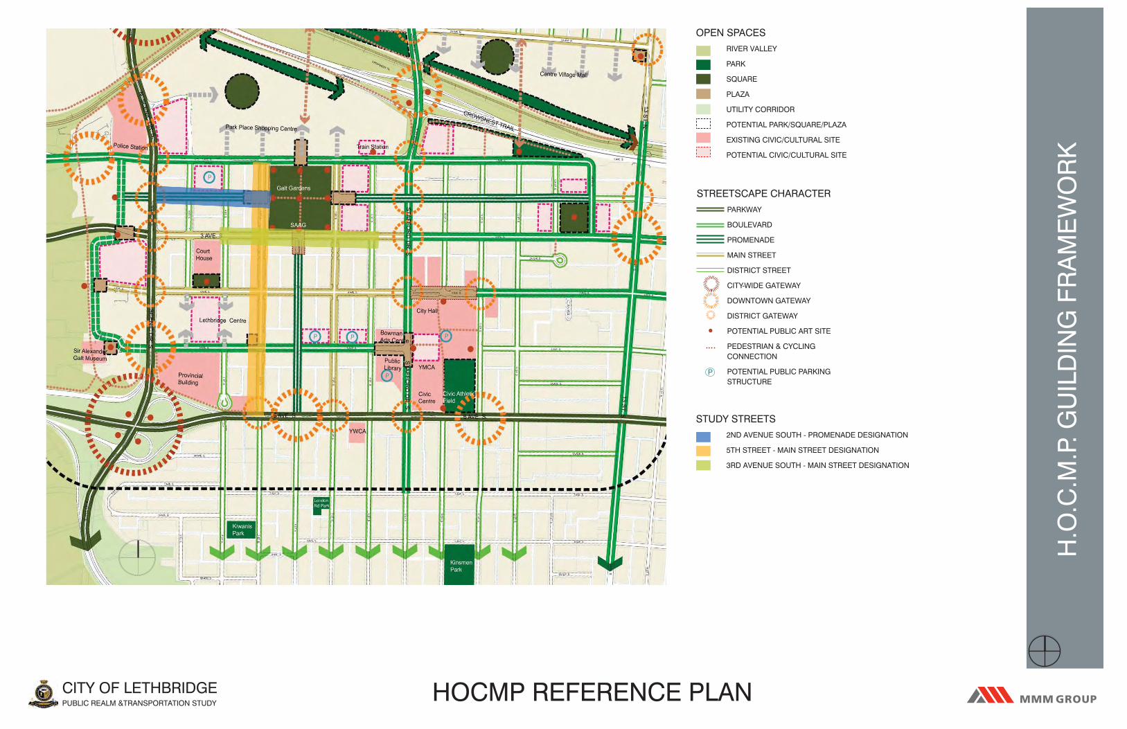
H.O
.C.M
.P. G
UIL
DIN
G F
RA
ME
WO
RK
CITY OF LETHBRIDGEPUBLIC REALM &TRANSPORTATION STUDY
HOCMP REFERENCE PLAN
OPEN SPACES
RIVER VALLEY
PARK
SQUARE
PLAZA
UTILITY CORRIDOR
POTENTIAL PARK/SQUARE/PLAZA
EXISTING CIVIC/CULTURAL SITE
POTENTIAL CIVIC/CULTURAL SITE
STUDY STREETS
2ND AVENUE SOUTH - PROMENADE DESIGNATION
5TH STREET - MAIN STREET DESIGNATION
3RD AVENUE SOUTH - MAIN STREET DESIGNATION
STREETSCAPE CHARACTER
PARKWAY
BOULEVARD
PROMENADE
MAIN STREET
DISTRICT STREET
CITY-WIDE GATEWAY
DOWNTOWN GATEWAY
DISTRICT GATEWAY
POTENTIAL PUBLIC ART SITE
PEDESTRIAN & CYCLING CONNECTION
POTENTIAL PUBLIC PARKING STRUCTURE
P

MAIN STREETS
INTENDED DOWNTOWN ROLE AND FUNCTION
��SERVES AS STREET-ORIENTED RETAIL CORRIDORS WITH HIGH PEDESTRIAN TRAFFIC��TYPICALLY IMPORTANT VEHICULAR CROSS STREETS ACCESSING THE DOWNTOWN CORE WITH
EAST-WEST ROUTES ALSO SERVING AS MAJOR THROUGH ROUTES�� IMPORTANT TRANSIT RIDER SOURCE AND DESTINATION��MIXED USE WITH CONTINUOUS RETAIL AT GRADE AND OFFICE OR RESIDENTIAL ABOVE GRADE
DEFINING DESIGN CHARACTERISTICS
�� 4 TRAVEL LANES��TREE-LINED SIDE BOULEVARDS ENHANCED WITH PLANTING BEDS AND/OR HUNG FLOWER
BASKETS TO REINFORCE APPEAL TO PEDESTRIAN TRAFFIC��MAXIMUM POSSIBLE SIDEWALK WIDTHS FOR HIGH PEDESTRIAN VOLUMES (NO LESS THAN 4.0
METRES IN WIDTH) AND INCLUDES ABUNDANT PEDESTRIAN ORIENTED FURNISHINGS��PARALLEL ON-STREET PARKING ONLY TO ENSURE ADEQUATE SIDEWALK WIDTHS-OTHERWISE
TO BE REDUCED BY ONE OR TWO LANES WHERE ANGLED PARKING REMAINS��APPROPRIATELY PLACE BUS STOPS FOR OPTIMUM PEDESTRIAN CONVENIENCE AND SAFETY��BUILDINGS WITH SHOP FRONTS CONSISTENTLY PLACED AT THE STREET EDGE PROVIDING
AWNINGS AND OTHER PEDESTRIAN AMENITIES��SIDEWALKS ACCOMMODATE SPILL-OUT COMMERCIAL ACTIVITY SUCH AS PATIOS
PROMENADES
INTENDED DOWNTOWN ROLE AND FUNCTION
��SERVES AS A GRAND ‘GREEN’ CORRIDOR THAT VISUALLY AND PHYSICALLY LINKS GALT GARDENS TO THE REST OF DOWNTOWN IN ALL DIRECTIONS
��ANCHORED BY PLAZAS AT GALT GARDENS��A PRIMARILY PEDESTRIAN-ORIENTED CONNECTION AND DESTINATION FOR PASSIVE AND ACTIVE
INTERESTS��TYPICALLY VEHICULAR TRAFFIC WILL BE LOCAL ORIENTED��TRANSIT ACCESSED ON ADJACENT STREET OR AT CROSS-STREETS��USES WILL VARY WITH LOCATION- MIXED WITH RETAIL IN THE CORE AND MORE RESIDENTIAL
OR OTHER USES FURTHER AWAY
DEFINING DESIGN CHARACTERISTICS
��2 TRAVEL LANES��DOUBLE ROW OF TREES ON EITHER SIDE OF THE STREET��PLAZA DEFINED BY FEATURED PAVING EXTENDING INTO THE ROADWAY WHICH CAN BE PARTIALLY
OR ENTIRELY CLOSED OFF FOR EVENTS��MAXIMUM POSSIBLE SIDEWALK WIDTHS IN THE CORE FOR HIGH PEDESTRIAN VOLUMES (NO
LESS THAN 9.0 METRES IN WIDTH) AND ACCOMMODATES AN ABUNDANCE OF PEDESTRIAN ORIENTED AMENITIES AND SPILL-OUT COMMERCIAL ACTIVITIES
��ANGLED ON-STREET PARKING MAY BE ACCOMMODATED IF ALTERNATING TO MAINTAIN THE CONSISTENT DOUBLE TREE LINE
��BUILDINGS CONSISTENTLY PLACED AT THE STREET EDGE WITHIN THE CORE BUT MAY VARY OTHERWISE. H
.O.C
.M.P
. PR
OP
OS
ED
SE
CTI
ON
S
CITY OF LETHBRIDGEPUBLIC REALM &TRANSPORTATION STUDY
PROMENADE PROTOTYPE OPTION 1.DEMONSTRATION OF RESIDENTIAL AREA WHERE MULTISTORY BUILDINGS SETBACK TO PERMIT MODEST FRONT YARD AND ACCESS POINTS FOR AT-GRADE ACCESS UNITS THAT FRONT
ONTO THE PROMENADE.
PROMENADE PROTOTYPE OPTION 2.ANGLED PARKING ALTERNATING AND PLAZA
TREATMENT.
PROMENADE PROTOTYPE OPTION 3.PARALLEL PARKING ALTERNATIVE TO OPTION 2.
MAIN STREET PROTOTYPE OPTION 1.TYPICAL CROSS-SECTION.
HOCMP SECTIONS

APPENDIX BDetailed Cost Estimate

5210038 - Lethbridge PRT Study 75% Preliminary Design
Estimate of Probable Costs
November 2011
Summary
Site Works
Including 15% Contingency
5th Street Phase 1 (1st - 4th Avenue) $2,579,979.00
5th Street Phase 2 (4th - 6th Avenue) $2,020,975.50
2nd Avenue (Scenic - 5th Street) $2,138,223.75
3rd Avenue (4th - 8th Street) $2,701,528.25
ESTIMATED TOTAL PROJECT BUDGET 9,440,706.50$

5210038 - Lethbridge PRT Study 75% Preliminary Design
Estimate of Probable Costs
November 2011
DESCRIPTION OF WORK Unit Quantity Cost Total
1.0 HARDSCAPE
1.1 Cast in Place Concrete Surface Materials
.1
Concrete for sidewalk c/w sawcuts. 100mm depth (including base
aggregates) sq.m. 3270 $100.00 327,000.00$
.2 Concrete pads for benches (site furnishings) ea. 9 $250.00 2,250.00$
.3 600mm wide concrete band for sidewalk l.m. 500 $300.00 150,000.00$
.4 600mm wide concrete band for traffic areas l.m. 150 $300.00 45,000.00$
.5 Curb and gutter placementl.m. 1470 $100.00 147,000.00$
1.2 Cast in Place Concrete Surface Materials - Removals
.1 Curb and gutter removall.m. 660 $32.00 21,120.00$
.2 Concrete surface removalsq.m. 2800 $22.00 61,600.00$
1.3 Asphalt Surface
.1 Asphalt paving for parking stalls (2 lifts including base aggregates) sq.m. 1500 $35.00 52,500.00$
.2 Asphalt paving for vehicular lanes sq.m. 4000 $25.00 100,000.00$
1.4 Asphalt Surface - Removals
.1 Cold milling asphalt sq.m. 5500 $3.00 16,500.00$
.2 Asphalt removal sq.m. 2000 $30.00 60,000.00$
SECTION 1.0 SUBTOTAL 982,970.00$
2nd Avenue (Scenic - 5th Street)

5210038 - Lethbridge PRT Study 75% Preliminary Design
Estimate of Probable Costs
November 2011
DESCRIPTION OF WORK Unit Quantity Cost Total
2nd Avenue (Scenic - 5th Street)
2.0 SOFTSCAPE
2.1 Grading and Excavation
.1 Shrub bed excavation (450mm depth) sq.m. 520 $15.00 7,800.00$
.2 Tree pit excavation (900mm depth) sq.m. 41 $30.00 1,230.00$
2.2 Fill, Topsoil and Mulch
.1 Imported growing medium for trees (1m depth) cu.m. 41 $45.00 1,845.00$
.2 Imported growing medium for shrub beds (450mm depth) cu.m. 235 $45.00 10,575.00$
.3 Composted bark mulch (50mm depth) cu.m. 25 $45.00 1,125.00$
2.3 Plant Materials and Sod
.1 Shrub / perennial planting sq.m. 520 $55.00 28,600.00$
.2 Deciduous Tree (7.5cm Cal.) ea. 41 $550.00 22,550.00$
2.4 Irrigation
.1 High efficiency irrigation system materials and labour for shrub beds sq.m. 520 $25.00 13,000.00$
.2 High efficiency irrigation system materials and labour for street trees l.m. 440 $8.00 3,520.00$
.3 Irrigation meter, backflow preventer and vault l.s. 1 $30,000.00 30,000.00$
.4 Pedestal and controller components l.s. 1 $15,000.00 15,000.00$
SECTION 2.0 SUBTOTAL 135,245.00$

5210038 - Lethbridge PRT Study 75% Preliminary Design
Estimate of Probable Costs
November 2011
DESCRIPTION OF WORK Unit Quantity Cost Total
2nd Avenue (Scenic - 5th Street)
3.0 SITE AMENITIES AND FEATURES
3.1 Bike Storage and Shelters
.1 Covered bike storage ea. 2 $6,500.00 13,000.00$
.2 Warming shelter ea. 1 $8,000.00 8,000.00$
.3 Wayfinding / Information Kiosk ea. 8 $3,500.00 28,000.00$
.4 Parking stub dispenser (solar powered) ea. 10 $7,500.00 75,000.00$
3.2 Site Furnishings
.1 Garbage receptacles ea. 12 $3,000.00 36,000.00$
.2 Catalogue benches ea. 9 $2,500.00 22,500.00$
.3 Pedestrian metal bollards ea. 89 $1,000.00 89,000.00$
.4 Rectangular Tree grates ea. 22 $2,500.00 55,000.00$
3.3 Removals
.1 Remove trees ea. 20 $900.00 18,000.00$
.2 Remove parking meter ea. 16 $100.00 1,600.00$
SECTION 3.0 SUBTOTAL 346,100.00$

5210038 - Lethbridge PRT Study 75% Preliminary Design
Estimate of Probable Costs
November 2011
DESCRIPTION OF WORK Unit Quantity Cost Total
2nd Avenue (Scenic - 5th Street)
4.0 ELECTRICAL/UTILITIES/ANCILLARY SERVICES
4.1 Lighting
.1 6.0m Hgt pedestrian pole top lights c/w precast base ea 15 $6,500.00 97,500.00$
.2 9.0m Hgt vehicle pole top lights c/w precast base + davit arm ea 15 $10,000.00 150,000.00$
4.2 Ancillary Services
.1 Catch basins ea. 8 $11,500.00 92,000.00$
.2 Adjust manholes ea. 7 $705.00 4,935.00$
.3 Relocate fire hydrants ea. 2 $1,000.00 2,000.00$
4.3 Removals
.1 Removal and disposal of existing lamp fixtures ea. 13 $475.00 6,175.00$
.2 Remove catch basins ea. 8 $5,300.00 42,400.00$
SECTION 4.0 SUBTOTAL 395,010.00$
ON-SITE LANDSCAPE SUBTOTAL 1,859,325.00$
15% Contingency 278,898.75$
ESTIMATED TOTAL ON-SITE LANDSCAPE BUDGET 2,138,223.75$

5210038 - Lethbridge PRT Study 75% Preliminary Design
Estimate of Probable Costs
November 2011
DESCRIPTION OF WORK Unit Quantity Cost Total
2nd Avenue (Scenic - 5th Street)
UPGRADE ITEMS
1.0 HARDSCAPE
1.1 Cast in Place Concrete Surface Materials
.1Reference 1.2.2 Traffic unit pavers for parking stalls (including base
aggregates). sq.m. 1500 $120.00 180,000.00$
.2Reference 1.2.2 Aquapave traffic unit pavers for parking stalls (including
base aggregates) . sq.m. 1500 $135.00 202,500.00$
2.0 SITE AMENITIES AND FEATURES
2.1 Site Furnishings
.1 Reference 3.2.4 decorative bollards. ea. 89 $1,750.00 155,750.00$
.2 Reference 3.2.4 replace bollards with C.I.P. concrete piers/bollards ea. 12 $3,000.00 36,000.00$
OPTIONAL ITEMS
1.0 HARDSCAPE ITEMS
1.1 Cast in Place Concrete Surface Materials
.1 Concrete for raised intersections (c/w sawcuts). 150mm depth (including
base aggregates) sq.m. 530 $120.00 63,600.00$
.2 Stamped and coloured concrete for raised intersections). 150mm depth
(including base aggregates) sq.m. 530 $135.00 71,550.00$
1.2 Urban Trees
.1 Silva cell for urban tree growth ea. 41 $11,000.00 451,000.00$
2.0 SITE AMENITIES AND FEATURES
2.1 Site Furnishings
.1 Garbage and recycling station (Big Belly Solar) ea. 6 $5,000.00 30,000.00$
.2 Public art / urban design allow 1 $50,000.00 50,000.00$
3.0 ELECTRICAL
3.1 Lighting
.1 G.F.I. Receptacles - General ea. 41 $650.00 26,650.00$
.2 Junction Boxes - General ea. 10 $500.00 5,000.00$
This is an estimate and not a guaranteed amount, and is to be used for budgetary purposes only.
Costing is based on 2011 contractor pricing and is subject to change.
Costing does not include extensive relocation or upgrading of existing services that may be required at time of construction.
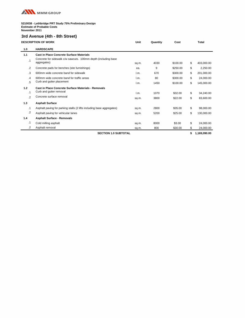
5210038 - Lethbridge PRT Study 75% Preliminary Design
Estimate of Probable Costs
November 2011
DESCRIPTION OF WORK Unit Quantity Cost Total
1.0 HARDSCAPE
1.1 Cast in Place Concrete Surface Materials
.1Concrete for sidewalk c/w sawcuts. 100mm depth (including base
aggregates) sq.m. 4030 $100.00 403,000.00$
.2 Concrete pads for benches (site furnishings) ea. 9 $250.00 2,250.00$
.3 600mm wide concrete band for sidewalk l.m. 670 $300.00 201,000.00$
.4 600mm wide concrete band for traffic areas l.m. 80 $300.00 24,000.00$
.5 Curb and gutter placementl.m. 1450 $100.00 145,000.00$
1.2 Cast in Place Concrete Surface Materials - Removals
.1 Curb and gutter removall.m. 1070 $32.00 34,240.00$
.2 Concrete surface removalsq.m. 3800 $22.00 83,600.00$
1.3 Asphalt Surface
.1 Asphalt paving for parking stalls (2 lifts including base aggregates) sq.m. 2800 $35.00 98,000.00$
.2 Asphalt paving for vehicular lanes sq.m. 5200 $25.00 130,000.00$
1.4 Asphalt Surface - Removals
.1 Cold milling asphalt sq.m. 8000 $3.00 24,000.00$
.2 Asphalt removal sq.m. 800 $30.00 24,000.00$
SECTION 1.0 SUBTOTAL 1,169,090.00$
3rd Avenue (4th - 8th Street)

5210038 - Lethbridge PRT Study 75% Preliminary Design
Estimate of Probable Costs
November 2011
DESCRIPTION OF WORK Unit Quantity Cost Total
3rd Avenue (4th - 8th Street)
2.0 SOFTSCAPE
2.1 Grading and Excavation
.1 Shrub bed excavation (450mm depth) sq.m. 420 $15.00 6,300.00$
.2 Tree pit excavation (900mm depth) sq.m. 10 $30.00 300.00$
2.2 Fill, Topsoil and Mulch
.1 Imported growing medium for trees (1m depth) cu.m. 10 $45.00 450.00$
.2 Imported growing medium for shrub beds (450mm depth) cu.m. 190 $45.00 8,550.00$
.3 Composted bark mulch (50mm depth) cu.m. 20 $45.00 900.00$
2.3 Plant Materials and Sod
.1 Shrub / perennial planting sq.m. 420 $55.00 23,100.00$
.2 Deciduous Tree (7.5cm Cal.) ea. 10 $550.00 5,500.00$
2.4 Irrigation
.1 High efficiency irrigation system materials and labour for shrub beds sq.m. 420 $25.00 10,500.00$
.2 High efficiency irrigation system materials and labour for street trees l.m. 400 $8.00 3,200.00$
.3 Irrigation meter, backflow preventer and vault l.s. 1 $30,000.00 30,000.00$
.4 Pedestal and controller components l.s. 1 $15,000.00 15,000.00$
SECTION 2.0 SUBTOTAL 103,800.00$

5210038 - Lethbridge PRT Study 75% Preliminary Design
Estimate of Probable Costs
November 2011
DESCRIPTION OF WORK Unit Quantity Cost Total
3rd Avenue (4th - 8th Street)
3.0 SITE AMENITIES AND FEATURES
3.1 Bike Storage and Shelters
.1 Covered bike storage ea. 2 $6,500.00 13,000.00$
.2 Bus shelter ea. 1 $8,000.00 8,000.00$
.3 Wayfinding / Information Kiosk ea. 10 $3,500.00 35,000.00$
.4 Parking stub dispenser (solar powered) ea. 12 $7,500.00 90,000.00$
3.2 Site Furnishings
.1 Garbage receptacles ea. 11 $3,000.00 33,000.00$
.2 Catalogue benches ea. 9 $2,500.00 22,500.00$
.3 Pedestrian metal bollards ea. 106 $1,000.00 106,000.00$
.4 Tree grates ea. 10 $2,200.00 22,000.00$
.5 Banner poles ea. 13 $4,500.00 58,500.00$
.6 Relocate / re-use conc. Peirs ea. 3 $1,500.00 4,500.00$
.7 Remove / relocate public art ea. 2 $1,200.00 2,400.00$
3.3 Removals
.1 Remove trees ea. 24 $900.00 21,600.00$
.2 Remove bike rack ea. 2 $200.00 400.00$
.3 Remove parking meter ea. 49 $100.00 4,900.00$
SECTION 3.0 SUBTOTAL 421,800.00$

5210038 - Lethbridge PRT Study 75% Preliminary Design
Estimate of Probable Costs
November 2011
DESCRIPTION OF WORK Unit Quantity Cost Total
3rd Avenue (4th - 8th Street)
4.0 ELECTRICAL/UTILITIES/ANCILLARY SERVICES
4.1 Lighting
.1 6.0m Hgt pedestrian pole top lights c/w precast base ea 24 $6,500.00 156,000.00$
.2 9.0m Hgt vehicle pole top lights c/w precast base + davit arm ea 24 $10,000.00 240,000.00$
4.2 Ancillary Services
.1 Catch basins ea. 11 $11,500.00 126,500.00$
.2 Adjust manholes ea. 13 $705.00 9,165.00$
.3 Relocate fire hydrants ea. 5 $1,000.00 5,000.00$
.4
Scramble Intersections (incl. auditory pedestrian signals and other electrical
services) l.s. 1 $50,000.00 50,000.00$
4.3 Removals
.1 Removal and disposal of existing lamp fixtures ea. 20 $475.00 9,500.00$
.2 Remove catch basins ea. 11 $5,300.00 58,300.00$
SECTION 4.0 SUBTOTAL 654,465.00$
ON-SITE LANDSCAPE SUBTOTAL 2,349,155.00$
15% Contingency 352,373.25$
ESTIMATED TOTAL ON-SITE LANDSCAPE BUDGET 2,701,528.25$

5210038 - Lethbridge PRT Study 75% Preliminary Design
Estimate of Probable Costs
November 2011
DESCRIPTION OF WORK Unit Quantity Cost Total
3rd Avenue (4th - 8th Street)
UPGRADE ITEMS
1.0 HARDSCAPE
1.1 Cast in Place Concrete Surface Materials
.1Reference 1.2.2 Traffic unit pavers for parking stalls (including base
aggregates). sq.m. 2800 $120.00 336,000.00$
.2Reference 1.2.2 Aquapave traffic unit pavers for parking stalls (including
base aggregates) . sq.m. 2800 $135.00 378,000.00$
2.0 SITE AMENITIES AND FEATURES
2.1 Site Furnishings
.1 Reference 3.2.4 Decorative bollards. ea. 106 $1,750.00 185,500.00$
.2 Reference 3.2.4 replace bollards with C.I.P. concrete piers/bollards ea. 3 $3,000.00 9,000.00$
OPTIONAL ITEMS
1.0 HARDSCAPE ITEMS
1.1 Cast in Place Concrete Surface Materials
.1Concrete for raised intersections (c/w sawcuts). 150mm depth (including
base aggregates) sq.m. 620 $120.00 74,400.00$
.2Stamped and coloured concrete for raised intersections). 150mm depth
(including base aggregates) sq.m. 620 $135.00 83,700.00$
1.2 Urban Trees
.1 Silva cell for urban tree growth ea. 10 $11,000.00 110,000.00$
2.0 SITE AMENITIES AND FEATURES
2.1 Site Furnishings
.1 Garbage and recycling station (Big Belly Solar) ea. 8 $5,000.00 40,000.00$
.2 Public art / urban design allow 1 $75,000.00 75,000.00$
3.0 ELECTRICAL
3.1 Lighting
.1 G.F.I. Receptacles - General ea. 28 $650.00 18,200.00$
.2 Junction Boxes - General ea. 8 $500.00 4,000.00$
This is an estimate and not a guaranteed amount, and is to be used for budgetary purposes only.
Costing is based on 2011 contractor pricing and is subject to change.
Costing does not include extensive relocation or upgrading of existing services that may be required at time of construction.

5210038 - Lethbridge PRT Study 75% Preliminary Design
Estimate of Probable Costs
November 2011
DESCRIPTION OF WORK Unit Quantity Cost Total
1.0 HARDSCAPE
1.1 Cast in Place Concrete Surface Materials
.1Concrete for sidewalk c/w sawcuts. 100mm depth (including base
aggregates) sq.m. 3700 $100.00 370,000.00$
.2 Concrete pads for benches (site furnishings) ea. 22 $250.00 5,500.00$
.3 600mm wide concrete band for sidewalk l.m. 900 $300.00 270,000.00$
.4 600mm wide concrete band for traffic areas l.m. 60 $300.00 18,000.00$
.5 Curb and gutter placementl.m. 900 $100.00 90,000.00$
.6 Concrete for medianssq.m. 125 $115.00 14,375.00$
1.2 Cast in Place Concrete Surface Materials - Removals
.1 Curb and gutter removall.m. 800 $32.00 25,600.00$
.2 Concrete surface removalsq.m. 2200 $22.00 48,400.00$
1.3 Asphalt Surface
.1 Asphalt paving for bike lane (1 lift including base aggregates) sq.m. 660 $20.00 13,200.00$
.2 Asphalt paving for parking stalls (2 lifts including base aggregates) sq.m. 1750 $35.00 61,250.00$
.3 Asphalt paving for vehicular lanes sq.m. 4000 $25.00 100,000.00$
1.4 Asphalt Surface - Removals
.1 Cold milling asphalt sq.m. 5750 $3.00 17,250.00$
.2 Asphalt removal sq.m. 3250 $30.00 97,500.00$
SECTION 1.0 SUBTOTAL 1,131,075.00$
5th Street Phase 1 (1st - 4th Avenue)

5210038 - Lethbridge PRT Study 75% Preliminary Design
Estimate of Probable Costs
November 2011
DESCRIPTION OF WORK Unit Quantity Cost Total
5th Street Phase 1 (1st - 4th Avenue)
2.0 SOFTSCAPE
2.1 Grading and Excavation
.1 Shrub bed excavation (450mm depth) sq.m. 500 $15.00 7,500.00$
.2 Tree pit excavation (900mm depth) sq.m. 42 $30.00 1,260.00$
2.2 Fill, Topsoil and Mulch
.1 Imported growing medium for trees (1m depth) cu.m. 42 $45.00 1,890.00$
.2 Imported growing medium for shrub beds (450mm depth) cu.m. 225 $45.00 10,125.00$
.3 Composted bark mulch (50mm depth) cu.m. 25 $45.00 1,125.00$
2.3 Plant Materials and Sod
.1 Shrub / perennial planting sq.m. 500 $55.00 27,500.00$
.2 Deciduous Tree (7.5cm Cal.) ea. 42 $550.00 23,100.00$
2.4 Irrigation
.1 High efficiency irrigation system materials and labour for shrub beds sq.m. 500 $25.00 12,500.00$
.2 High efficiency irrigation system materials and labour for street trees l.m. 800 $8.00 6,400.00$
.3 Irrigation meter, backflow preventer and vault l.s. 1 $30,000.00 30,000.00$
.4 Pedestal and controller components l.s. 1 $15,000.00 15,000.00$
SECTION 2.0 SUBTOTAL 136,400.00$

5210038 - Lethbridge PRT Study 75% Preliminary Design
Estimate of Probable Costs
November 2011
DESCRIPTION OF WORK Unit Quantity Cost Total
5th Street Phase 1 (1st - 4th Avenue)
3.0 SITE AMENITIES AND FEATURES
3.1 Bike Storage and Shelters
.1 Covered bike storage ea. 2 $6,500.00 13,000.00$
.2 Warming shelter ea. 1 $8,000.00 8,000.00$
.3 Wayfinding / Information Kiosk ea. 3 $3,500.00 10,500.00$
.4 Parking stub dispenser (solar powered) ea. 8 $7,500.00 60,000.00$
3.2 Site Furnishings
.1 Garbage receptacles ea. 10 $3,000.00 30,000.00$
.2 Catalogue benches ea. 22 $2,500.00 55,000.00$
.3 Bicycle racks (10 Stall) ea. 2 $1,500.00 3,000.00$
.4 Pedestrian metal bollards ea. 126 $1,000.00 126,000.00$
.5 Tree grates ea. 42 $2,200.00 92,400.00$
3.3 Removals
.1 Remove trees ea. 4 $900.00 3,600.00$
.2 Remove bike rack ea. 3 $200.00 600.00$
.3 Remove parking meter ea. 57 $100.00 5,700.00$
SECTION 3.0 SUBTOTAL 407,800.00$

5210038 - Lethbridge PRT Study 75% Preliminary Design
Estimate of Probable Costs
November 2011
DESCRIPTION OF WORK Unit Quantity Cost Total
5th Street Phase 1 (1st - 4th Avenue)
4.0 ELECTRICAL/UTILITIES/ANCILLARY SERVICES
4.1 Lighting
.1 6.0m Hgt pedestrian pole top lights c/w precast base ea 18 $6,500.00 117,000.00$
.2 9.0m Hgt vehicle pole top lights c/w precast base + davit arm ea 19 $10,000.00 190,000.00$
4.2 Ancillary Services
.1 Catch basins ea. 11 $11,500.00 126,500.00$
.2 Adjust manholes ea. 17 $705.00 11,985.00$
.3 Relocate fire hydrants ea. 3 $1,000.00 3,000.00$
.4
Scramble Intersections (incl. auditory pedestrian signals and other electrical
services) l.s. 1 $50,000.00 50,000.00$
4.3 Removals
.1 Removal and disposal of existing lamp fixtures ea. 24 $475.00 11,400.00$
.2 Remove catch basins ea. 11 $5,300.00 58,300.00$
SECTION 4.0 SUBTOTAL 568,185.00$
ON-SITE LANDSCAPE SUBTOTAL 2,243,460.00$
15% Contingency 336,519.00$
ESTIMATED TOTAL ON-SITE LANDSCAPE BUDGET 2,579,979.00$

5210038 - Lethbridge PRT Study 75% Preliminary Design
Estimate of Probable Costs
November 2011
DESCRIPTION OF WORK Unit Quantity Cost Total
5th Street Phase 1 (1st - 4th Avenue)
UPGRADE ITEMS
1.0 HARDSCAPE
1.1 Cast in Place Concrete Surface Materials
.1 Reference 1.2.1 Concrete paving for bike lane (including base aggregates). sq.m. 660 $100.00 66,000.00$
.2Reference 1.2.2 Traffic unit pavers for parking stalls (including base
aggregates). sq.m. 1750 $120.00 210,000.00$
.3Reference 1.2.2 Aquapave traffic unit pavers for parking stalls (including
base aggregates) . sq.m. 1750 $135.00 236,250.00$
2.0 SITE AMENITIES AND FEATURES
2.1 Site Furnishings
.1 Reference 3.2.4 decorative bollards. ea. 126 $1,750.00 220,500.00$
OPTIONAL ITEMS
1.0 HARDSCAPE ITEMS
1.1 Cast in Place Concrete Surface Materials
.1Concrete for raised intersections (c/w sawcuts). 150mm depth (including
base aggregates) sq.m. 550 $120.00 66,000.00$
.2Stamped and coloured concrete for raised intersections). 150mm depth
(including base aggregates) sq.m. 150 $135.00 20,250.00$
1.2 Concrete Seatwalls and Feature Walls
.1 C.I.P concrete seat walls - 450mm height l.m. 30 $1,000.00 30,000.00$
.2 C.I.P concrete feature walls with brick veneer - 450mm height l.m. 15 $1,500.00 22,500.00$
1.3 Urban Trees
.1 Silva cell for urban tree growth ea. 42 $11,000.00 462,000.00$
2.0 SITE AMENITIES AND FEATURES
2.1 Site Furnishings
.1 Catalogue benches ea. 18 $2,500.00 45,000.00$
.2 Garbage and recycling station (Big Belly Solar) ea. 2 $5,000.00 10,000.00$
.3 Public art allow 1 $200,000.00 200,000.00$
.4 Gateway features (Obilisk) allow 8 $10,000.00 80,000.00$
3.0 ELECTRICAL
3.1 Lighting
.1 6.0m Hgt pedestrian pole top lights c/w precast base ea 9 $6,500.00 58,500.00$
.2 4.8m Hgt pedestrian pole top lights c/w 1.2m Hgt. conc custcom base ea 4 $12,000.00 48,000.00$
.3 G.F.I. Receptacles - General ea. 42 $650.00 27,300.00$
.4 Junction Boxes - General ea. 10 $500.00 5,000.00$
This is an estimate and not a guaranteed amount, and is to be used for budgetary purposes only.
Costing is based on 2011 contractor pricing and is subject to change.
Costing does not include extensive relocation or upgrading of existing services that may be required at time of construction.

5210038 - Lethbridge PRT Study 75% Preliminary Design
Estimate of Probable Costs
November 2011
DESCRIPTION OF WORK Unit Quantity Cost Total
1.0 HARDSCAPE
1.1 Cast in Place Concrete Surface Materials
.1Concrete for sidewalk c/w sawcuts. 100mm depth (including base
aggregates) sq.m. 3200 $100.00 320,000.00$
.2 Concrete pads for benches (site furnishings) ea. 1 $250.00 250.00$
.3 600mm wide concrete band for sidewalk l.m. 700 $300.00 210,000.00$
.4 600mm wide concrete band for traffic areas l.m. 50 $300.00 15,000.00$
.5 Curb and gutter placementl.m. 800 $100.00 80,000.00$
.6 Concrete for medianssq.m. 125 $115.00 14,375.00$
1.2 Cast in Place Concrete Surface Materials - Removals
.1 Curb and gutter removall.m. 700 $32.00 22,400.00$
.2 Concrete surface removalsq.m. 2400 $22.00 52,800.00$
1.3 Asphalt Surface
.1 Asphalt paving for bike lane (1 lift including base aggregates) sq.m. 625 $20.00 12,500.00$
.2 Asphalt paving for parking stalls (2 lifts including base aggregates) sq.m. 1630 $35.00 57,050.00$
.3 Asphalt paving for vehicular lanes sq.m. 3800 $25.00 95,000.00$
1.4 Asphalt Surface - Removals
.1 Cold milling asphalt sq.m. 5430 $3.00 16,290.00$
.2 Asphalt removal sq.m. 2670 $30.00 80,100.00$
SECTION 1.0 SUBTOTAL 975,765.00$
5th Street Phase 2 (4th - 6th Avenue)

5210038 - Lethbridge PRT Study 75% Preliminary Design
Estimate of Probable Costs
November 2011
DESCRIPTION OF WORK Unit Quantity Cost Total
5th Street Phase 2 (4th - 6th Avenue)
2.0 SOFTSCAPE
2.1 Grading and Excavation
.1 Shrub bed excavation (450mm depth) sq.m. 500 $15.00 7,500.00$
.2 Tree pit excavation (900mm depth) sq.m. 29 $30.00 870.00$
2.2 Fill, Topsoil and Mulch
.1 Imported growing medium for trees (1m depth) cu.m. 29 $45.00 1,305.00$
.2 Imported growing medium for shrub beds (450mm depth) cu.m. 225 $45.00 10,125.00$
.3 Composted bark mulch (50mm depth) cu.m. 25 $45.00 1,125.00$
2.3 Plant Materials and Sod
.1 Shrub / perennial planting sq.m. 500 $55.00 27,500.00$
.2 Deciduous Tree (7.5cm Cal.) ea. 23 $550.00 12,650.00$
2.4 Irrigation
.1 High efficiency irrigation system materials and labour for shrub beds sq.m. 500 $25.00 12,500.00$
.2 High efficiency irrigation system materials and labour for street trees l.m. 560 $8.00 4,480.00$
.3 Irrigation meter, backflow preventer and vault l.s. 1 $30,000.00 30,000.00$
.4 Pedestal and controller components l.s. 1 $15,000.00 15,000.00$
SECTION 2.0 SUBTOTAL 123,055.00$

5210038 - Lethbridge PRT Study 75% Preliminary Design
Estimate of Probable Costs
November 2011
DESCRIPTION OF WORK Unit Quantity Cost Total
5th Street Phase 2 (4th - 6th Avenue)
3.0 SITE AMENITIES AND FEATURES
3.1 Bike Storage and Shelters
.1 Covered bike storage ea. 1 $6,500.00 6,500.00$
.2 Warming shelter ea. 1 $8,000.00 8,000.00$
.3 Wayfinding / Information Kiosk ea. 3 $3,500.00 10,500.00$
.4 Parking stub dispenser (solar powered) ea. 8 $7,500.00 60,000.00$
3.2 Site Furnishings
.1 Garbage receptacles ea. 6 $3,000.00 18,000.00$
.2 Catalogue benches ea. 3 $2,500.00 7,500.00$
.3 Bicycle racks (10 Stall) ea. 2 $1,500.00 3,000.00$
.4 Pedestrian metal bollards ea. 105 $1,000.00 105,000.00$
.5 Tree grates ea. 29 $2,200.00 63,800.00$
3.3 Removals
.1 Remove trees ea. 15 $900.00 13,500.00$
.2 Remove bike rack ea. 3 $200.00 600.00$
.3 Remove parking meter ea. 21 $100.00 2,100.00$
SECTION 3.0 SUBTOTAL 298,500.00$

5210038 - Lethbridge PRT Study 75% Preliminary Design
Estimate of Probable Costs
November 2011
DESCRIPTION OF WORK Unit Quantity Cost Total
5th Street Phase 2 (4th - 6th Avenue)
4.0 ELECTRICAL/UTILITIES/ANCILLARY SERVICES
4.1 Lighting
.1 46.0m Hgt pedestrian pole top lights c/w precast base ea 15 $6,500.00 97,500.00$
.2 9.0m Hgt vehicle pole top lights c/w precast base + davit arm ea 16 $10,000.00 160,000.00$
4.2 Ancillary Services
.1 Catch basins ea. 5 $11,500.00 57,500.00$
.2 Adjust manholes ea. 10 $705.00 7,050.00$
.3 Relocate fire hydrants ea. 2 $1,000.00 2,000.00$
4.3 Removals
.1 Removal and disposal of existing lamp fixtures ea. 20 $475.00 9,500.00$
.2 Remove catch basins ea. 5 $5,300.00 26,500.00$
SECTION 4.0 SUBTOTAL 360,050.00$
ON-SITE LANDSCAPE SUBTOTAL 1,757,370.00$
15% Contingency 263,605.50$
ESTIMATED TOTAL ON-SITE LANDSCAPE BUDGET 2,020,975.50$

5210038 - Lethbridge PRT Study 75% Preliminary Design
Estimate of Probable Costs
November 2011
DESCRIPTION OF WORK Unit Quantity Cost Total
5th Street Phase 2 (4th - 6th Avenue)
UPGRADE ITEMS
1.0 HARDSCAPE
1.1 Cast in Place Concrete Surface Materials
.1 Reference 1.2.1 Concrete paving for bike lane (including base aggregates). sq.m. 625 $100.00 62,500.00$
.2Reference 1.2.2 Traffic unit pavers for parking stalls (including base
aggregates). sq.m. 1630 $120.00 195,600.00$
.3Reference 1.2.2 Aquapave traffic unit pavers for parking stalls (including
base aggregates) . sq.m. 1630 $135.00 220,050.00$
2.0 SITE AMENITIES AND FEATURES
2.1 Site Furnishings
.1 Reference 3.2.4 Decorative bollards. ea. 105 $1,750.00 183,750.00$
OPTIONAL ITEMS
1.0 HARDSCAPE ITEMS
1.1 Cast in Place Concrete Surface Materials
.1Concrete for raised intersections (c/w sawcuts). 150mm depth (including
base aggregates) sq.m. 510 $120.00 61,200.00$
.2Stamped and coloured concrete for raised intersections). 150mm depth
(including base aggregates) sq.m. 150 $135.00 20,250.00$
1.2 Concrete Seatwalls and Feature Walls
.1 C.I.P concrete seat walls - 450mm height l.m. 25 $1,000.00 25,000.00$
1.3 Urban Trees
.1 Silva cell for urban tree growth ea. 26 $11,000.00 286,000.00$
2.0 SITE AMENITIES AND FEATURES
2.1 Site Furnishings
.1 Garbage and recycling station (Big Belly Solar) ea. 1 $5,000.00 5,000.00$
.2 Public art allow 1 $150,000.00 150,000.00$
.3 Gateway features (Obilisk) allow 1 $10,000.00 10,000.00$
3.0 ELECTRICAL
3.1 Lighting
.1 G.F.I. Receptacles - General ea. 29 $650.00 18,850.00$
.2 Junction Boxes - General ea. 7 $500.00 3,500.00$
This is an estimate and not a guaranteed amount, and is to be used for budgetary purposes only.
Costing is based on 2011 contractor pricing and is subject to change.
Costing does not include extensive relocation or upgrading of existing services that may be required at time of construction.


