30
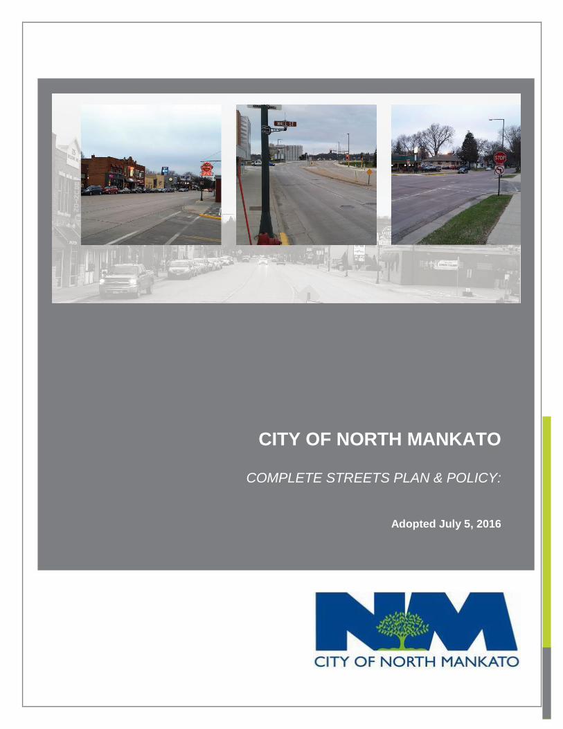
CITY OF NORTH MANKATO COMPLETE STREETS PLAN & POLICY: Adopted July 5, 2016
CITY OF NORTH MANKATO
COMPLETE STREETS PLAN & POLICY: CLIENT
Adopted July 5, 2016
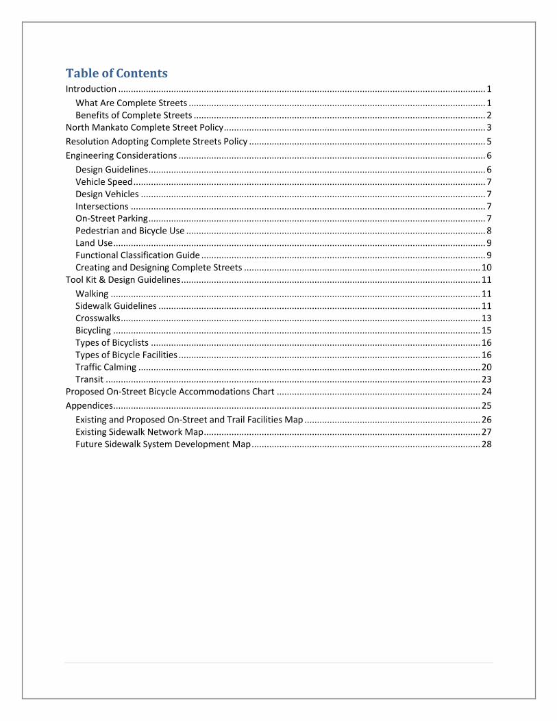
Table of Contents Introduction .................................................................................................................................................. 1
What Are Complete Streets ...................................................................................................................... 1 Benefits of Complete Streets .................................................................................................................... 2
North Mankato Complete Street Policy ........................................................................................................ 3
Resolution Adopting Complete Streets Policy .............................................................................................. 5
Engineering Considerations .......................................................................................................................... 6
Design Guidelines ...................................................................................................................................... 6 Vehicle Speed ............................................................................................................................................ 7 Design Vehicles ......................................................................................................................................... 7 Intersections ............................................................................................................................................. 7 On-Street Parking ...................................................................................................................................... 7 Pedestrian and Bicycle Use ....................................................................................................................... 8 Land Use .................................................................................................................................................... 9 Functional Classification Guide ................................................................................................................. 9 Creating and Designing Complete Streets .............................................................................................. 10
Tool Kit & Design Guidelines ....................................................................................................................... 11
Walking ................................................................................................................................................... 11 Sidewalk Guidelines ................................................................................................................................ 11 Crosswalks ............................................................................................................................................... 13 Bicycling .................................................................................................................................................. 15 Types of Bicyclists ................................................................................................................................... 16 Types of Bicycle Facilities ........................................................................................................................ 16 Traffic Calming ........................................................................................................................................ 20 Transit ..................................................................................................................................................... 23
Proposed On-Street Bicycle Accommodations Chart ................................................................................. 24
Appendices .................................................................................................................................................. 25
Existing and Proposed On-Street and Trail Facilities Map ...................................................................... 26 Existing Sidewalk Network Map .............................................................................................................. 27 Future Sidewalk System Development Map ........................................................................................... 28

Introduction
What Are Complete
Streets Complete Streets are
streets and sidewalks that
are designed and
constructed to serve
everyone – pedestrians,
bicyclists, and drivers – and
they take into account the
transportation needs of all
people, including children,
older adults, and people
with disabilities or impaired
mobility.
As state and local governments have worked to improve the road network, they have primarily
focused on efficiency or making the flow of traffic better for drivers. This has resulted in
overbuilt roadways with additional turn or travel lanes that increase the walking distance across
intersections and reduce shoulder area to bicyclists. Traffic signals are timed and phased to
facilitate vehicles moving through intersections. The curve radius at intersections have
increased so traffic can turn at higher speeds which also increases the walking distance across
the intersection.
The emphasis on improving the efficiency of vehicle traffic had in many cases created streets
that are unfriendly to pedestrians and bicyclists creating an increasing need to drive. Complete
Streets policies and projects are aimed at changing streets from places where vehicles
dominate to places where all users are accommodated.
Complete Streets may include the following elements:
Pedestrian and ADA Compliant Elements. Sidewalks, crosswalks, curb ramps,
accessible pedestrian signals, detectable tactile cues and warning, and longer intervals;
Bicycle Elements. Bicycle routes and lanes, signage and pavement marking, and bicycle
racks;
Streetscape Elements. Street trees, landscaping, rain gardens, permeable paving
materials, and buffers between vehicles and people;
Traffic Calming and Access Management Elements. Intersection bump outs, curb
extensions, textured material, and center refuge islands. Driveway consolidations,
modifications and closures; and
Transit and Parking Elements. Accessible bus stops, shelters and pull-out integrated
with pedestrian enhancements. Delineated on-street parking spaces and curb/sidewalk
bump-outs.
PLACE PHOTO HERE,
OTHERWISE DELETE BOX

2 | P a g e
Benefits of Complete Streets Streets are an integral part of North Mankato and they affect the quality of life and character of
our community. They connect neighborhoods, and provide access to businesses, jobs, schools,
shopping and services. Complete Streets provide multiple benefits to communities and
residents:
Downtown Revitalization and Economic Health. Business districts with Complete Streets
that are inviting for pedestrian and bicyclists report higher retail sales, a higher
percentage of residents shopping locally, and increased appeal to visitors;
Safe Places for Children to Walk, Bike and Play. Complete Streets can help increase the
percentage of children walking and biking to school, which has declined dramatically in
the past 50 years;
Reduced Transportation Costs. Complete Streets with improved options for walking and
biking helps people save money as U.S. families typically spend between 20% and 40%
of their income on transportation;
Active Living and Good Health. Residents in neighborhoods with Complete Streets who
have safe places to walk and bike close to home are more likely to be physically active,
which is associated with lower rates of obesity and chronic disease;
Improved Mobility for Older Adults and People with Disabilities. Complete Streets
(including sidewalk networks) that are accessible and easy to navigate improve
transportation options for older adults and people with physical, vision or cognitive
disabilities or impairments; and
Environmental Health. Complete Streets with improved options for walking and biking
helps reduce vehicle miles driven and associated pollution, particularly pollution and
greenhouse gases.
PLACE PHOTO HERE,
OTHERWISE DELETE BOX

3 | P a g e
North Mankato Complete Street Policy
Background
Complete Streets is a transportation policy and design approach that guides streets to be
planned, designed, operated, and maintained to enable safe, convenient and comfortable travel
and access for users of all ages and abilities regardless of their mode of transportation.
What constitutes safe, convenient, and comfortable travel and access for users of all ages and
abilities regardless of mode of transportation may change from time to time or from project to
project to avoid confusion and heightened expectation of this policy. For example, pedestrians
and bicycles can be adequately accommodated by allowing them to share the street with
vehicles on low-volume residential streets. Based on these factors varying issues, the North
Mankato City Council may request staff to further define what conditions, such as traffic
volumes/speeds, truck volumes of topographic conditions, will trigger the need to construct
designated pedestrian and bicycle facilities.
Design Standards and Maintenance
The City Council or their designee will consider bicycle and pedestrian design in all
streets construction, reconstruction, rehabilitation and pavement maintenance projects
conducted by or behalf of the City, as appropriate, subject to the exceptions contained
herein.
The City shall plan, design, build and maintain all bicycle and pedestrian facilities in
accordance with acceptable federal, state and local standards and guidelines, but will
consider innovative and/or non-traditional design options as appropriate.
Design Standard Exceptions
The incorporation of bicycle and pedestrian facilities shall be considered in street
construction, reconstruction and pavement maintenance projects undertaken by or on
behalf of the City during the regular design process, except under one or more of the
following conditions:
a. There is insufficient space within the right of way to safely accommodate such
new facilities.
b. Inclusion of such new facilities would require an excessive and disproportionate
cost.
c. Inclusion of such new facilities would create a public safety risk for users of the
public right of way.
d. Inclusion of such new facilities are not in the public interest.
e. The project in limited to routine or seasonal maintenance activities such as
mowing, sweeping, or spot pavement repairs, including chip and crack sealing
activities.
f. Bicyclists and pedestrians are prohibited by law from using the facility.
g. There is documentation that there is an absence of current or future need.
4 | P a g e
The City Council or their designee shall document the reasoning for their decision to
exempt the particular project from the Complete Streets Policy during the engineering
feasibility reporting process.
Plan Review Process and Reports
Planning studies and/or engineering feasibility reports for street projects prepared by or
on behalf of the City will include discussion of whether the Complete Streets Policy was
applicable to the project, how Complete Streets was considered during the plan
development, and what elements of Complete Streets are recommended for inclusion in
the project.

5 | P a g e
Resolution Adopting Complete Streets Policy
WHEREAS, the City of North Mankato recognizes that its transportation network (e.g., streets, sidewalks, trails and
pathways) is intended to balance the needs and interests of all users of all ages and abilities; and
WHEREAS, streets are a key factor in the experience of the public realm and play a crucial role in economic
development, public safety and health and overall quality of life; and
WHEREAS, the design and function of our streets has often favored the motorist over other users, notably bicyclists,
pedestrians, transit users and persons with disabilities; and
WHEREAS, Active Transportation integrates physical activity into daily lives through increased emphasis on walking,
bicycling, and public transportation; and
WHEREAS, Active Transportation improves public health, reduces traffic congestion, enhances air quality and
supports local economic development; and
WHEREAS, the City of North Mankato has recently completed a Complete Streets Plan and Policy which serves as a
guide for public investment and incorporating multimodal transportation; and
WHEREAS, the City of North Mankato seeks to create an interconnected network of transportation facilities which
accommodates all modes of travel in a manner that is consistent with neighborhood context and supportive of
community goals; and
WHEREAS, Complete Streets are defined as streets that are planned, designed, operated and maintained to enable
safe access for all users and upon which pedestrians, bicyclists, transit users, persons with disabilities, and motorists
of all ages and abilities are able to safely move along and across streets; and
WHEREAS, the City of North Mankato seeks to establish a Complete Streets policy to incorporate Active
Transportation into the planning, design and operation of all future City street projects whether new construction,
reconstruction, rehabilitation, or pavement maintenance; and
WHEREAS, it is recognized that certain streets may not be feasible, whether physically or financially, for Complete
Streets accommodation.
NOW THEREFORE, BE IT RESOLVED BY THE CITY COUNCIL OF NORTH MANKATO, MINNESOTA:
1. The City Council of the City of North Mankato approves and adopts the Complete Streets Policy attached to this
Resolution.
This resolution shall become effective upon its adoption.
Passed this 4th day of January, 2016

6 | P a g e
Engineering Considerations
The Complete Streets plan is part of a City's Vision to meet the needs for various modes of
transportation and providing a safe network of facilities to accommodate access and travel for
all users. For Complete Streets to be successful, every road project should be evaluated for
compliance with the Complete Streets Policy and guiding principles. Road projects vary across
a spectrum from the new development of roadways in subdivision development to the
reconstruction of existing streets. Other roadway projects can include surface improvements
such as milling and overlay, seal coating, chip sealing and resurfacing projects.
Modifications to streets within North Mankato shall be reviewed in accordance with proven and
accepted design criteria. Transportation projects shall be reviewed to meet
the criteria of safety, feasibility, proper application and policies established
by the engineering department.
Design Guidelines When designing roadway projects within North Mankato, it is important to
consider nationally and regionally recognized
guidelines. This will provide the best approach for
creating standards for new features or transportation
facilities within the right of way. This will provide
consistency and reduce the potential for conflict. The
following is a list of commonly accepted guidelines for
street design the City of North Mankato will utilize as
resources:
A Policy on Geometric Design of Highways and
Streets, 6th Edition, AASHTO
Guide for the Development of Bicycle Facilities,
4th Edition, AASHTO
Guide for the Planning, Design, and Operation of Pedestrian
Facilities, 1st Edition, AASHTO
Manual on Uniform Traffic Control Devices, Federal Highway Administration
o Bicycle Facilities and the Manual on Uniform Traffic Control Devices, Federal
Highway Administration
Public Rights of Way Accessibility Guidelines, U.S. Access Board
Memorandum: Bicycle and Pedestrian Facility Design Flexibility, Federal Highway
Administration
Designing Walkable Urban Thoroughfares: A Context Sensitive Approach: An ITE
Recommended Practice, Institute of Transportation Engineers and the Congress for the
New Urbanism
Urban Bikeway Design Guide, National Association of City Transportation Officials

7 | P a g e
Urban Street Design Guide, National Association of City Transportation Officials
Highway Capacity Manual 2010, Transportation Research Board
Complete Streets Complete Networks, Active Transportation Alliance
Vehicle Speed Vehicle target speed is the 85th percentile speed that is desired for a given
street. Lowering vehicle speeds is a primary goal for Complete Streets
because it directly impacts the severity as well as number of crash-related
injuries and fatalities.
Target speed can be achieved through a combination of engineering
treatments, driver education, and police enforcement. Streets should be
designed with target speeds and speed limits that are appropriate for both their current and future
context, including roadway classification and street type, as well as adjacent land uses and user
demand.
Specific design treatments are capable of achieving predictable
speed and volume reductions, though their benefits must
balance with the potential impacts on parking and emergency
vehicles. On local roads and in school zones, target speeds
should be set at or below 30 MPH in order for pedestrian safety
to be maximized.
Design Vehicles A design vehicle is a vehicle type that needs to be accommodated in the design of the roadway or intersection. Street functional classification will help determine the intended vehicle type as well as the land use in the area. In order to design safe and efficient intersections along its route, it is extremely important to select the design vehicle which will be using them. All roadway designs shall meet the minimum standards for the needs of the fire department as well as other emergency vehicles.
Intersections Intersections are significant points of conflict within the street system. Their impact on safety,
capacity, speed, and user costs is considerable. For this reason, intersections deserve special
attention in their design. Design considerations should include the type of traffic control,
capacity analysis, degree of access control for the functional classification of the street,
pedestrian traffic, bicycle traffic and lighting. The use of small turning radii, raised intersections,
crosswalks, lighting, textured pavement, roundabouts and other speed mitigating design
elements should be prioritized whenever possible to improve that safety for all users.
On-Street Parking On-street parking is beneficial in the many areas of North Mankato that have limited off-street
parking. On-street parking can also provide a traffic calming benefit providing increased safety

8 | P a g e
as drivers tend to travel at slower speeds. These slower speeds provide pedestrians, bicyclists
and drivers more time to react; and when a crash does occur, the severity is greatly reduced.
On-street parking designs can include parallel parking, 45 and 60 degree parking as well as
reverse angle parking. The benefits of on-street parking should only be implemented with the
use of appropriate design elements to avoid negative consequences.
Pedestrian and Bicycle Use All roadway designs shall take into consideration pedestrian and bicycle use of all ages and
abilities. Factors that contribute to a quality environment for both bicyclists and pedestrians can
include the following:
Pleasant visual environment
Network of existing infrastructure separated from traffic. Boulevards created along the
street provide a more appealing sidewalk to walk along vs. a sidewalk that is built
curbside
Short street crossing distances
American with Disabilities (ADA) Requirements
Safety of the pedestrian and separation from high speed traffic is of the utmost importance in
planning for pedestrian facilities. Complete streets need to provide for a range of passive and
active uses including, but not limited to walking, waiting for transit, and crossing the street.
While specific treatments or dimensions may vary by context, the goal in any environment is to
have a continuous pedestrian network that provides dedicated space for pedestrians and
separation from vehicles.
Factors that contribute to successful bicycle routes include the following:
a well-connected network of bicycling facilities
well marked bicycle routes
safe travel routes
direct travel routes, particularly when bicycling for purposes other than strictly exercise
or recreation
When determining bicycle routes, factors such as surrounding land use, the speed of vehicles
on the street and the directness of the route connecting destination, should all be considered.
An additional consideration includes the different types of bicyclists with varying levels of
expertise and comfort riding in mixed traffic. Creating viable transportation options means that a
variety of facility types should be provided to create a bicycling network.
9 | P a g e
Land Use Street designs should take into consideration the various land uses throughout North Mankato.
Areas zoned as residential will have different design requirements than areas that are zoned as
Central Business District or Commercial. Street designs will need to accommodate the adjacent
land uses and the users of the street. Commercial and industrial areas will likely need larger
turning radii and larger travel lanes to accommodate commercial trucks. Residential areas may
have speed and traffic volume issues which may require other engineering treatments to
provide necessary safety for all users.
Functional Classification Guide Like most jurisdictions in the United States, North Mankato's streets have been categorized in
order to better understand how they serve motor vehicle traffic. Each road’s classification has
been determined by the state using guidelines developed by the American Association of State
Highway and Transportation Officials (AASHTO). Complete Streets projects must take into
consideration this roadway classification as it helps determine how the road and network needs
to be treated to handle the traffic volumes and other conflicts that may arise as a result of
design changes. It is also often used in determining Federal or State funding criteria when
improvements are needed. The road classifications for the urban environment of North Mankato
are as follows:
Principal Arterial
Serve major activity centers, highest traffic volume corridors and longest trip demands
Carry high proportion of total urban travel on minimum mileage
Interconnect and provide continuity for major rural corridors to accommodate trips
entering and leaving urban area and movements through the urban area
Serve demand for intra-area travel between the central business district and outlying
residential areas
Minor Arterial
Interconnect and augment the higher-level Arterials
Serve trips of moderate length at a somewhat lower level of travel mobility than Principal
Arterials
Distribute traffic to smaller geographic areas than those served by higher-level Arterials
Provide more land access than Principal Arterials without penetrating identifiable
neighborhoods
Provide urban connections for Rural Collectors
Major Collector
Serve both land access and traffic circulation in higher density residential and
commercial/industrial areas
Penetrate residential neighborhoods, often for significant distances
Distribute and channel trips between Local Roads and Arterials, usually over a distance
of greater than three-quarters of a mile
Operating characteristics include higher speeds and more signalized intersections
10 | P a g e
Minor Collector
Serve both land access and traffic circulation in lower density residential and
commercial/industrial areas
Penetrate residential neighborhoods, often only for a short distance
Distribute and channel trips between Local Roads and Arterials, usually over a distance
of less than three-quarters of a mile
Operating characteristics include lower speeds and fewer signalized intersections
Local Road
Provide direct access to adjacent land
Provide access to higher systems
Carry no through traffic movement
Constitute the mileage not classified as part of the Arterial or Collector systems
Creating and Designing Complete Streets A variety of design treatments and engineering solutions can be created in any street design. It
is important to involve the community, provide engineering, and education necessary for
successful implementation. The City of North Mankato has created a tool box which shows
many possible treatments. This tool box, as documented below, will be utilized as a starting
point. This toolbox will provide guidance in determining which elements are most appropriate
and feasible to the street in design.
11 | P a g e
Tool Kit & Design Guidelines
Walking We start and end nearly every trip as a pedestrian. Despite this, walking is often the least
considered mode of travel when it comes to providing convenient, safe and adequate facilities.
Well-designed pedestrian facilities can create a more walkable environment, where pedestrians
feel safe and secure because they are not intimidated by adjacent traffic.
Sidewalk Guidelines While the design of a sidewalk depends on its location and function, the following general
guidelines should be considered:
Sidewalks should be at least 5 feet wide. If sidewalks are too narrow, fewer people can
use them, people have to walk single file, and people may be uncomfortably close to
buildings and/or automobile traffic. Narrow sidewalks may not provide enough clear space
for people who use walking aids or wheelchairs. Even wider sidewalks should be installed
in areas near schools, on commercial streets, or in other areas where there will be many
people walking. The minimum width for an Americans with Disabilities Act (ADA)-
compliant sidewalk is 3 feet, but sidewalks this narrow should be limited to short distances
and wider passing spaces may need be provided at set intervals if the sidewalk is less
than 5' across. Wheel chair ramps with detectable warning domes should be installed
where sidewalks cross a curb, and existing ramps should be upgraded to meet current
ADA guidelines.
Obstructions – such as utility poles, untrimmed trees or shrubs, or illegally parked
vehicles – can create even narrower spaces with little room to maneuver around them.
Narrow sidewalks are also more likely to have driveway crossings with steep cross slopes
and curb ramps with insufficient landings and/or steep ramp grades.
There should be at least a 4-foot buffer between the sidewalk and the vehicle travel
lane. As pedestrians, we feel more secure when there is a buffer between ourselves and
moving vehicles. The buffer may include an on-street parking lane, an on-street bike lane,
greenspace or planting strips, raised curbs, space for street trees, street furniture, street
lights or utility poles, or a combination of those elements.
Sidewalks should be at least 8 feet wide where buildings abut the sidewalk. The
three additional feet of sidewalk is needed so that doors can be opened and people can
enter and exit buildings without blocking the sidewalk for other pedestrians.
Sidewalks should continue across driveways. Sidewalks should not be paved over in
order to maintain a continuous, level surface with minimal cross-slope.
Sidewalks should be constructed of concrete or a material with a similar lifespan
and performance.
12 | P a g e
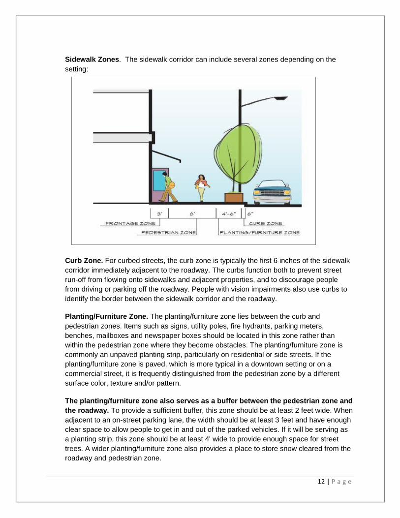
Sidewalk Zones. The sidewalk corridor can include several zones depending on the
setting:
Curb Zone. For curbed streets, the curb zone is typically the first 6 inches of the sidewalk
corridor immediately adjacent to the roadway. The curbs function both to prevent street
run-off from flowing onto sidewalks and adjacent properties, and to discourage people
from driving or parking off the roadway. People with vision impairments also use curbs to
identify the border between the sidewalk corridor and the roadway.
Planting/Furniture Zone. The planting/furniture zone lies between the curb and
pedestrian zones. Items such as signs, utility poles, fire hydrants, parking meters,
benches, mailboxes and newspaper boxes should be located in this zone rather than
within the pedestrian zone where they become obstacles. The planting/furniture zone is
commonly an unpaved planting strip, particularly on residential or side streets. If the
planting/furniture zone is paved, which is more typical in a downtown setting or on a
commercial street, it is frequently distinguished from the pedestrian zone by a different
surface color, texture and/or pattern.
The planting/furniture zone also serves as a buffer between the pedestrian zone and
the roadway. To provide a sufficient buffer, this zone should be at least 2 feet wide. When
adjacent to an on-street parking lane, the width should be at least 3 feet and have enough
clear space to allow people to get in and out of the parked vehicles. If it will be serving as
a planting strip, this zone should be at least 4' wide to provide enough space for street
trees. A wider planting/furniture zone also provides a place to store snow cleared from the
roadway and pedestrian zone.

13 | P a g e
Pedestrian Zone. The portion of the sidewalk corridor specifically reserved for people to
walk on is the pedestrian zone. It should be completely free of obstacles, protruding
objects, and vertical obstructions, which are particularly hazardous to pedestrians with
vision impairments who may not be able to detect or avoid them. The appropriate width of
this portion of the sidewalk corridor is discussed above.
Frontage Zone. The frontage zone is the area between the pedestrian zone and the
property line. A frontage zone is needed when buildings are located right at the edge of
the sidewalk, most common in a downtown setting or on a commercial street. This zone
should not be less than 1 foot wide and may need to be wider to accommodate building
doors that open out into the sidewalk corridor and other activities at the edge of the
sidewalk. Sidewalk cafes, protruding display windows, street vendors, sandwich board
signs, and sidewalk sales may all occur or be located within the frontage zone if there is
adequate width. Like the planting/furniture zone, the frontage zone is frequently
distinguished from the pedestrian zone by a different surface color, texture and/or pattern.
If the sidewalk corridor is adjacent to lawns or landscaped areas, as is common on
residential streets, a frontage zone will not be needed.
Crosswalks
Crosswalk Guidelines. As pedestrians, we are at risk whenever we have to cross the
roadway. For this reason, sidewalk networks should be designed to minimize the number
of times people need to cross the road when walking between destinations. Marked
crosswalks are an effective method for improving safety and reducing accidents.
Crosswalks indicate the preferred locations for pedestrians to cross a street and provide
warning to motorists that people may be crossing. The following are guidelines for
crosswalks which should be considered:
The length of crosswalks should be minimized and signals appropriately timed to
allow all pedestrians to cross safely. A shorter crossing distance improves safety by
minimizing pedestrians’ exposure to moving traffic. Long crossing distances also make it
more difficult for seniors, children and people with impaired mobility to safely cross a
street. Median refuge islands should be considered for crossings that are more than 60
feet long.
Crosswalks located at intersections are preferred to those located at mid-block.
Typically, crosswalks should be installed at intersections controlled by either stop signs or
a traffic control signal. Mid-block locations are acceptable when warranted by heavy
pedestrian traffic or to provide access to a major pedestrian destination. When the
distance to the nearest crosswalk is more than 500 feet, people are more likely to jaywalk
rather than walking a long distance to the crosswalk and a mid-block crosswalk may be
justified. Crosswalks are implied at all intersections whether or not they are marked, while
mid-block crossings can only be created by a marked crosswalk.
14 | P a g e
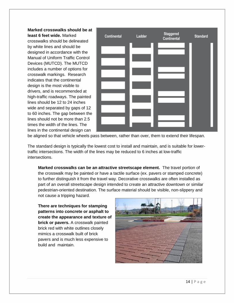
Marked crosswalks should be at
least 6 feet wide. Marked
crosswalks should be delineated
by white lines and should be
designed in accordance with the
Manual of Uniform Traffic Control
Devices (MUTCD). The MUTCD
includes a number of options for
crosswalk markings. Research
indicates that the continental
design is the most visible to
drivers, and is recommended at
high-traffic roadways. The painted
lines should be 12 to 24 inches
wide and separated by gaps of 12
to 60 inches. The gap between the
lines should not be more than 2.5
times the width of the lines. The
lines in the continental design can
be aligned so that vehicle wheels pass between, rather than over, them to extend their lifespan.
The standard design is typically the lowest cost to install and maintain, and is suitable for lower-
traffic intersections. The width of the lines may be reduced to 6 inches at low-traffic
intersections.
Marked crosswalks can be an attractive streetscape element. The travel portion of
the crosswalk may be painted or have a tactile surface (ex. pavers or stamped concrete)
to further distinguish it from the travel way. Decorative crosswalks are often installed as
part of an overall streetscape design intended to create an attractive downtown or similar
pedestrian-oriented destination. The surface material should be visible, non-slippery and
not cause a tripping hazard.
There are techniques for stamping
patterns into concrete or asphalt to
create the appearance and texture of
brick or pavers. A crosswalk painted
brick red with white outlines closely
mimics a crosswalk built of brick
pavers and is much less expensive to
build and maintain.
15 | P a g e
Marked crosswalks require regular maintenance. Crosswalk markings will require
regular repainting or replacement, particularly on heavily traveled streets. The standard or
solid designs are frequently used on low-volume residential or side streets, and their
simple design reduces installation and maintenance costs.
Street lighting should be installed at all street intersections. Mid-block
street lighting should typically be installed on residential and collector streets in areas of
high pedestrian or bicycle activity (such as schools, parks, transit stops and centers,
access to transit, and commercial and recreational facilities that draw large numbers of
pedestrians) and along all arterial streets. There are many different types of lighting
sources and fixtures available to the designer. Regardless of the lighting equipment used,
the level and consistency of lighting provided, the design should normally conform to RP-
8, “American National Standard Practice for Roadway Lighting,” and guidance provided by
the Illuminating Engineering Society of North America.
Complete street lighting designs should:
Ensure pedestrian walkways and crossways are sufficiently lit;
Consider adding pedestrian-level lighting in areas of higher pedestrian volumes,
downtown, and at key intersections;
Install lighting on both sides of streets in commercial districts; and use uniform
lighting levels.
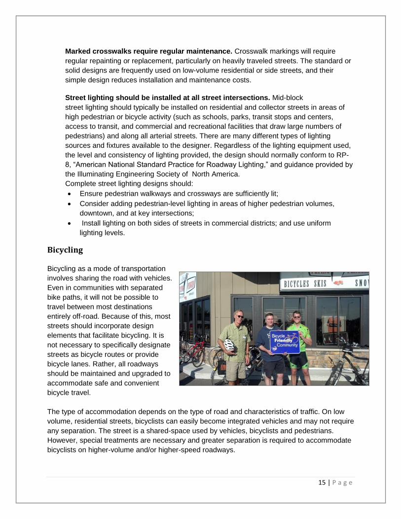
Bicycling Bicycling as a mode of transportation
involves sharing the road with vehicles.
Even in communities with separated
bike paths, it will not be possible to
travel between most destinations
entirely off-road. Because of this, most
streets should incorporate design
elements that facilitate bicycling. It is
not necessary to specifically designate
streets as bicycle routes or provide
bicycle lanes. Rather, all roadways
should be maintained and upgraded to
accommodate safe and convenient
bicycle travel.
The type of accommodation depends on the type of road and characteristics of traffic. On low
volume, residential streets, bicyclists can easily become integrated vehicles and may not require
any separation. The street is a shared-space used by vehicles, bicyclists and pedestrians.
However, special treatments are necessary and greater separation is required to accommodate
bicyclists on higher-volume and/or higher-speed roadways.
16 | P a g e
Types of Bicyclists Three categories of bicyclists should be considered: young children, the average rider, and the
advanced bicyclist. North Mankato allows young children to bicycle on the sidewalk, but older
children and adults are encouraged to bike on the road. Advanced bicyclists are generally
comfortable riding with vehicles even in high-traffic situations, but the average rider will probably
not be comfortable where there is not a designated space for bicycling such as a bike lane or
shoulder. Because the majority of bicyclists are young children or average riders, bicycle
facilities should be designed to serve their needs.
Young children and average riders prefer low volume, low-speed roads or designated bicycle
facilities with well-defined separation from motorized vehicles. These riders are best served by a
well-marked network of neighborhood streets and designated bicycle facilities. However, on
higher-volume and/or higher-speed roadways, special treatments are necessary and greater
separation is required to accommodate bicyclists that are at least 4 feet wide to feel comfortable
riding on shared roadways.
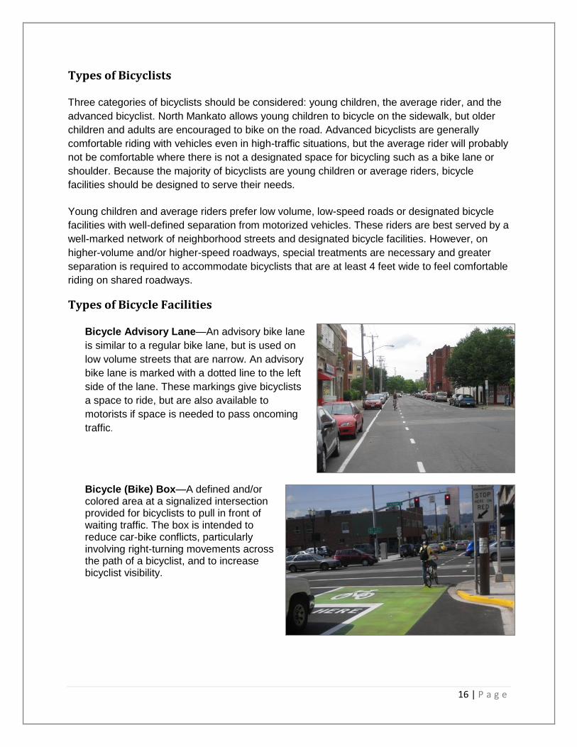
Types of Bicycle Facilities Bicycle Advisory Lane—An advisory bike lane
is similar to a regular bike lane, but is used on
low volume streets that are narrow. An advisory
bike lane is marked with a dotted line to the left
side of the lane. These markings give bicyclists
a space to ride, but are also available to
motorists if space is needed to pass oncoming
traffic.
Bicycle (Bike) Box—A defined and/or colored area at a signalized intersection provided for bicyclists to pull in front of waiting traffic. The box is intended to reduce car-bike conflicts, particularly involving right-turning movements across the path of a bicyclist, and to increase bicyclist visibility.
17 | P a g e
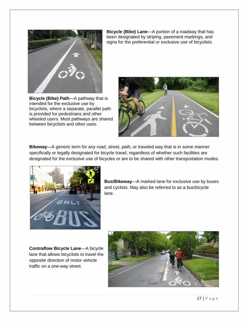
Bicycle (Bike) Lane—A portion of a roadway that has been designated by striping, pavement markings, and signs for the preferential or exclusive use of bicyclists.
Bicycle (Bike) Path—A pathway that is intended for the exclusive use by bicyclists, where a separate, parallel path is provided for pedestrians and other wheeled users. Most pathways are shared between bicyclists and other uses.
Bikeway—A generic term for any road, street, path, or traveled way that is in some manner
specifically or legally designated for bicycle travel, regardless of whether such facilities are
designated for the exclusive use of bicycles or are to be shared with other transportation modes.
Bus/Bikeway—A marked lane for exclusive use by buses
and cyclists. May also be referred to as a bus/bicycle
lane.
Contraflow Bicycle Lane—A bicycle
lane that allows bicyclists to travel the
opposite direction of motor vehicle
traffic on a one-way street.

18 | P a g e
Cycle Track—A bicycle facility, typically unidirectional, that is separated from motor vehicle
travel lanes, as well as sidewalks and pedestrians, by a physical barrier such as on-street
parking or a curb, or is grade-
separated.
On-road Accommodation—A facility
that is part of the roadway or traveled
way that is typically used by bicyclists
and/or motor vehicles such as a
shared lane, wide curb lane, bicycle
lane, or bikeable shoulder.
Off-road Accommodation—A path
that is separate from the roadway used by motor vehicles. This may be parallel to a roadway or
separate, as it may pass through parks within the public right-of-way or on private right-of-way.
This can be separated from pedestrian traffic (bicycle path) or shared with pedestrian traffic
(shared use path).
Paved Shoulder—The portion of the roadway
contiguous with the traveled way for accommodation of
stopped vehicles, for emergency use, and for lateral
support of sub-base, base, and surface courses. Use by
cyclists may be allowed or prohibited based upon specific
State laws.
Separated Bicycle Facility—A bikeway
within or adjacent to the roadway and
separated from moving traffic by barriers
or curbs, parking lanes, striped buffers,
and other means. Separated bicycle
facilities may be unidirectional or
bidirectional.
19 | P a g e
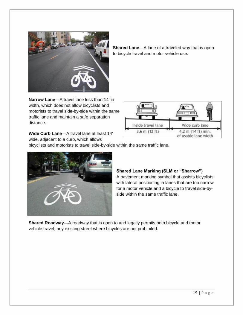
Shared Lane—A lane of a traveled way that is open
to bicycle travel and motor vehicle use.
Narrow Lane—A travel lane less than 14' in
width, which does not allow bicyclists and
motorists to travel side-by-side within the same
traffic lane and maintain a safe separation
distance.
Wide Curb Lane—A travel lane at least 14'
wide, adjacent to a curb, which allows
bicyclists and motorists to travel side-by-side within the same traffic lane.
Shared Lane Marking (SLM or “Sharrow”)
A pavement marking symbol that assists bicyclists
with lateral positioning in lanes that are too narrow
for a motor vehicle and a bicycle to travel side-by-
side within the same traffic lane.
Shared Roadway—A roadway that is open to and legally permits both bicycle and motor
vehicle travel; any existing street where bicycles are not prohibited.

20 | P a g e
Shared Use Path—A bikeway physically
separated from motorized vehicular traffic by
an open space or barrier and either within the
highway right-of-way or within an independent
right-of-way. Shared use paths may also be
used by pedestrians, skaters, wheelchair
users, joggers, and other non-motorized users.
Such facilities are often referred to as “trails.”
Signed Shared Roadway
(Signed Bike Route)—A shared roadway that
has been designated by signing as a preferred
route for bicycle use.
Trail—Non-descriptive general term typically
referring to off-roadway facilities but with no
standardized definition. Use should generally be
avoided as it may refer to a range of facilities,
including a coarse, unpaved hiking/biking route or a
paved urbanized facility.
Traffic Calming Pedestrian and bicyclist safety can also be addressed by altering how vehicles occupy and use
the street. There are a variety of techniques, commonly referred to as traffic calming measures,
that involve making physical changes to the roadway in order to alter driver behavior, reduce
travel speeds and provide a safer environment for pedestrians and bicyclists.
The aim of traffic calming is to balance the needs of motorists with other users, including
pedestrians and bicyclists. Instead of treating the street only as a conduit for vehicles passing
through at the greatest possible speed, it becomes shared space that creates a sense of place.
Traffic calming techniques are designed to reduce the impact of motor vehicle traffic by slowing
traffic, or literally “calming” it. This makes streets friendlier to pedestrians and bicyclists. Traffic
calming measures are frequently combined with streetscape improvements such as
landscaping, decorative pavement, street lights, benches, bike racks, or similar amenities to
make the street a pleasant place to be. Low-impact development approaches to managing
storm water may also be integrated into traffic calming projects.
Traffic calming can be applied inexpensively and flexibly. Many of the strategies employ painting
lines, colors and patterns on existing pavement; using planters, installing bollards, planters or
other removable barriers; eliminating or adding parking; or installing sidewalk extensions or
similar structures at intersections and crosswalks. Many traffic calming measures can be tested
through temporary installations that once fine-tuned can be rebuilt with more permanent
materials.
21 | P a g e
Common traffic calming measures include:
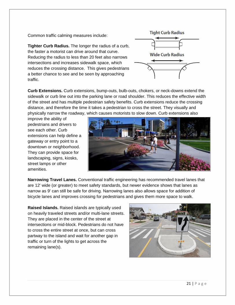
Tighter Curb Radius. The longer the radius of a curb,
the faster a motorist can drive around that curve.
Reducing the radius to less than 20 feet also narrows
intersections and increases sidewalk space, which
reduces the crossing distance. This gives pedestrians
a better chance to see and be seen by approaching
traffic.
Curb Extensions. Curb extensions, bump-outs, bulb-outs, chokers, or neck-downs extend the
sidewalk or curb line out into the parking lane or road shoulder. This reduces the effective width
of the street and has multiple pedestrian safety benefits. Curb extensions reduce the crossing
distance, and therefore the time it takes a pedestrian to cross the street. They visually and
physically narrow the roadway, which causes motorists to slow down. Curb extensions also
improve the ability of
pedestrians and drivers to
see each other. Curb
extensions can help define a
gateway or entry point to a
downtown or neighborhood.
They can provide space for
landscaping, signs, kiosks,
street lamps or other
amenities.
Narrowing Travel Lanes. Conventional traffic engineering has recommended travel lanes that
are 12' wide (or greater) to meet safety standards, but newer evidence shows that lanes as
narrow as 9' can still be safe for driving. Narrowing lanes also allows space for addition of
bicycle lanes and improves crossing for pedestrians and gives them more space to walk.
Raised Islands. Raised islands are typically used
on heavily traveled streets and/or multi-lane streets.
They are placed in the center of the street at
intersections or mid-block. Pedestrians do not have
to cross the entire street at once, but can cross
partway to the island and wait for another gap in
traffic or turn of the lights to get across the
remaining lane(s).
22 | P a g e
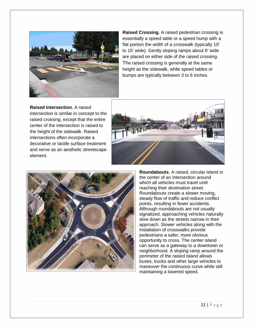
Raised Crossing. A raised pedestrian crossing is
essentially a speed table or a speed hump with a
flat portion the width of a crosswalk (typically 10'
to 15' wide). Gently sloping ramps about 6' wide
are placed on either side of the raised crossing.
The raised crossing is generally at the same
height as the sidewalk, while speed tables or
bumps are typically between 3 to 6 inches.
Raised Intersection. A raised
intersection is similar in concept to the
raised crossing, except that the entire
center of the intersection is raised to
the height of the sidewalk. Raised
intersections often incorporate a
decorative or tactile surface treatment
and serve as an aesthetic streetscape
element.
Roundabouts. A raised, circular island in the center of an intersection around which all vehicles must travel until reaching their destination street. Roundabouts create a slower moving, steady flow of traffic and reduce conflict points, resulting in fewer accidents. Although roundabouts are not usually signalized, approaching vehicles naturally slow down as the streets narrow in their approach. Slower vehicles along with the installation of crosswalks provide pedestrians a safer, more obvious opportunity to cross. The center island can serve as a gateway to a downtown or neighborhood. A sloping ramp around the perimeter of the raised island allows buses, trucks and other large vehicles to maneuver the continuous curve while still maintaining a lowered speed.
23 | P a g e
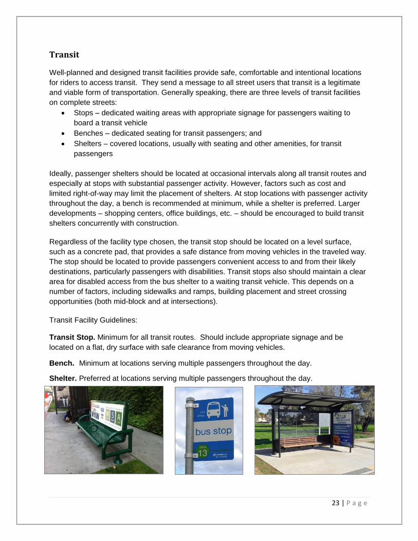
Transit Well-planned and designed transit facilities provide safe, comfortable and intentional locations
for riders to access transit. They send a message to all street users that transit is a legitimate
and viable form of transportation. Generally speaking, there are three levels of transit facilities
on complete streets:
Stops – dedicated waiting areas with appropriate signage for passengers waiting to
board a transit vehicle
Benches – dedicated seating for transit passengers; and
Shelters – covered locations, usually with seating and other amenities, for transit
passengers
Ideally, passenger shelters should be located at occasional intervals along all transit routes and
especially at stops with substantial passenger activity. However, factors such as cost and
limited right-of-way may limit the placement of shelters. At stop locations with passenger activity
throughout the day, a bench is recommended at minimum, while a shelter is preferred. Larger
developments – shopping centers, office buildings, etc. – should be encouraged to build transit
shelters concurrently with construction.
Regardless of the facility type chosen, the transit stop should be located on a level surface,
such as a concrete pad, that provides a safe distance from moving vehicles in the traveled way.
The stop should be located to provide passengers convenient access to and from their likely
destinations, particularly passengers with disabilities. Transit stops also should maintain a clear
area for disabled access from the bus shelter to a waiting transit vehicle. This depends on a
number of factors, including sidewalks and ramps, building placement and street crossing
opportunities (both mid-block and at intersections).
Transit Facility Guidelines: Transit Stop. Minimum for all transit routes. Should include appropriate signage and be
located on a flat, dry surface with safe clearance from moving vehicles.
Bench. Minimum at locations serving multiple passengers throughout the day.
Shelter. Preferred at locations serving multiple passengers throughout the day.

24 | P a g e
Proposed On-Street Bicycle Accommodations Chart
Bike Lanes
Shared
Lane
Roe Crest
(Lee to Marie)30 1,200 41' 2 lanes Both Sides X No Marking
Marie Lane
(Roe Crest to Lookout)30 1,650 44' 2 lanes Both Sides X Center stripe
Tower
(Marie to Lee)30 810 44' 2 lanes Both Sides X Center Stripe
Tower
(Lee to Commerce)30 2,500 44' 2 lanes None X Center Stripe
Commerce
(LorRay to Lookout)30
4,100 to
11,00052' 3 lanes None X Center Turn Lane
Lee Boulevard
(Lookout to Hoover)30 3,250 44' 2 lanes None X Center stripe
Lee Boulevard
(Hoover to LorRay)30
3,600 to
5,60044' 2 lanes One Side South Side Only X Center stripe
Pleasantview
(Northridge to Peregrine)30 3,000 36' 2 lanes One Side East Side Only X No Marking
Pleasantview
(Peregrine to Rockford Road)30 3,000 40' 2 lanes Both Sides X No Marking
Range Street (Nicollet to
McKinley)30
3,300 to
3,80040' 2 lanes West Side X Center stripe
Range Street McKinley to
Webster)30 3,300 44' 2 lanes Both Sides X Center stripe
Webster Avenue (Range to TH
169)30 4,150 2 lanes Off-Steet Bike Path
North River Road/Pauley Way30 36' 2 lanes Both Sides X No Marking
Commerce Drive (Lor Ray to
Colette Drive)30
2,000
(est.)44' 2 lanes One Side
South Side Only from
Lor Ray Drive to 550'
west of Collette
X Center stripe
Commerce Drive (Collete Drive
to Mary Circle)30
1,000
(est.)36' 2 lanes Both Sides X No Marking
Mary Circle/Candi Lane/Mary
Lane (Commerce to Bluff Park
Entrance)
30
500 to
800
(est.)
36' 2 lanes Both Sides X No Marking
Notes
Proposed Bicycle
Accomodations
Street Name
Speed
Limit ADT
Curb & Gutter
Opening
Thru Traffic
Lanes Parking

25 | P a g e
Appendices

Existing and Proposed On-Street and Trail Facilities Map

Existing Sidewalk Network Map

28 | P a g e
Future Sidewalk System Development Map


