Orlando, 08/02/2017 ESRI Water Conference One Water February 7-9, 2017 Orlando, FL ANTONIO ANNIS, UNIVERSITY OF FLORENCE FERNANDO NARDI, WARREDOC, UNIVERSITY FOR FOREIGNERS OF PERUGIA City of Rome and flood risk implementing an innovative GIS-based procedure integrating geomorphic, hydrologic and 2D hydraulic models for updating inundation maps in ungauged basins of the historical center
Transcript
Orlando, 08/02/2017
ESRI Water ConferenceOne Water
February 7-9, 2017 Orlando, FL
ANTONIO ANNIS, UNIVERSITY OF FLORENCE
FERNANDO NARDI, WARREDOC, UNIVERSITY FOR FOREIGNERS OF PERUGIA
City of Rome and flood riskimplementing an innovative GIS-based procedure
integrating geomorphic, hydrologic and 2D hydraulic models for updating inundation maps in ungauged basins of the
historical center
Orlando, 08/02/2017 Antonio Annis
ESRI WATER CONFERENCECity of Rome and flood risk: implementing an innovative GIS-based procedure integrating geomorphic, hydrologic and 2D hydraulic
models for updating inundation maps in ungauged basins of the historical centre
2
Summary
Case Study
Data
Models
Methodology
Results
Orlando, 08/02/2017 Antonio Annis
ESRI WATER CONFERENCECity of Rome and flood risk: implementing an innovative GIS-based procedure integrating geomorphic, hydrologic and 2D hydraulic
models for updating inundation maps in ungauged basins of the historical centre
3
Case Study: the city of Rome
220 km of simulated river channels with an average bridge/culvert inter-distance of 300-400m
Orlando, 08/02/2017 Antonio Annis
ESRI WATER CONFERENCECity of Rome and flood risk: implementing an innovative GIS-based procedure integrating geomorphic, hydrologic and 2D hydraulic
models for updating inundation maps in ungauged basins of the historical centre
4
Case Study: higly urbanized ungaged basins
Increasing frequency of rainfall-induced floods in the secondary river network
Orlando, 08/02/2017 Antonio Annis
ESRI WATER CONFERENCECity of Rome and flood risk: implementing an innovative GIS-based procedure integrating geomorphic, hydrologic and 2D hydraulic
models for updating inundation maps in ungauged basins of the historical centre
5
Data
Satellite imageryLidar
Land UseSoil type
Cartography
Digitized stream network
UAVs DEM
Orlando, 08/02/2017 Antonio Annis
ESRI WATER CONFERENCECity of Rome and flood risk: implementing an innovative GIS-based procedure integrating geomorphic, hydrologic and 2D hydraulic
models for updating inundation maps in ungauged basins of the historical centre
6
Data
Collection of VGI data for
understanding past flood events
Orlando, 08/02/2017 Antonio Annis
ESRI WATER CONFERENCECity of Rome and flood risk: implementing an innovative GIS-based procedure integrating geomorphic, hydrologic and 2D hydraulic
models for updating inundation maps in ungauged basins of the historical centre
7
Data
Generation of an integrated GIS
databaseArcGIS Online
StoryMap
Orlando, 08/02/2017 Antonio Annis
ESRI WATER CONFERENCECity of Rome and flood risk: implementing an innovative GIS-based procedure integrating geomorphic, hydrologic and 2D hydraulic
models for updating inundation maps in ungauged basins of the historical centre
8
Models
• An Ad Hoc GIS toolbox has been developed
Terrain pre-procesing
Hydrologicmodelling
Floodproneareas
delineation
Bridges -culvertsanalysis
1D-2D hydraulicmodelling
Flow depthsPost-
Processing
Topographicsurveys
Orlando, 08/02/2017 Antonio Annis
ESRI WATER CONFERENCECity of Rome and flood risk: implementing an innovative GIS-based procedure integrating geomorphic, hydrologic and 2D hydraulic
models for updating inundation maps in ungauged basins of the historical centre
9
• HYDROBASE
Models
Orlando, 08/02/2017 Antonio Annis
ESRI WATER CONFERENCECity of Rome and flood risk: implementing an innovative GIS-based procedure integrating geomorphic, hydrologic and 2D hydraulic
models for updating inundation maps in ungauged basins of the historical centre
10
• Hydrologic modellingModels
Orlando, 08/02/2017 Antonio Annis
ESRI WATER CONFERENCECity of Rome and flood risk: implementing an innovative GIS-based procedure integrating geomorphic, hydrologic and 2D hydraulic
models for updating inundation maps in ungauged basins of the historical centre
11
ModelsHydrologic modelling: Rain time series for calibration
Orlando, 08/02/2017 Antonio Annis
ESRI WATER CONFERENCECity of Rome and flood risk: implementing an innovative GIS-based procedure integrating geomorphic, hydrologic and 2D hydraulic
models for updating inundation maps in ungauged basins of the historical centre
12
ModelsVAPI (Valutazione Piene in Italia) :
m(SZO)))((
),(),,,(
c
mcttSZOb
SZOTaSZOytTi
c
ctmct tiSZOytThcc),,,(
Spatially distributed design rainfall based on statistical
extreme analysisimplemented in the GIS tool
Orlando, 08/02/2017 Antonio Annis
ESRI WATER CONFERENCECity of Rome and flood risk: implementing an innovative GIS-based procedure integrating geomorphic, hydrologic and 2D hydraulic
models for updating inundation maps in ungauged basins of the historical centre
13
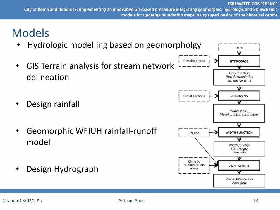
• GIS Terrain analysis for stream network delineation
• Design rainfall
• Geomorphic WFIUH rainfall-runoff model
• Design Hydrograph
• Hydrologic modelling based on geomorpholgyModels
Orlando, 08/02/2017 Antonio Annis
ESRI WATER CONFERENCECity of Rome and flood risk: implementing an innovative GIS-based procedure integrating geomorphic, hydrologic and 2D hydraulic
models for updating inundation maps in ungauged basins of the historical centre
14
• Preliminary identification of the critical culverts using GIS hydro-
tools
Models
Orlando, 08/02/2017 Antonio Annis
ESRI WATER CONFERENCECity of Rome and flood risk: implementing an innovative GIS-based procedure integrating geomorphic, hydrologic and 2D hydraulic
models for updating inundation maps in ungauged basins of the historical centre
15
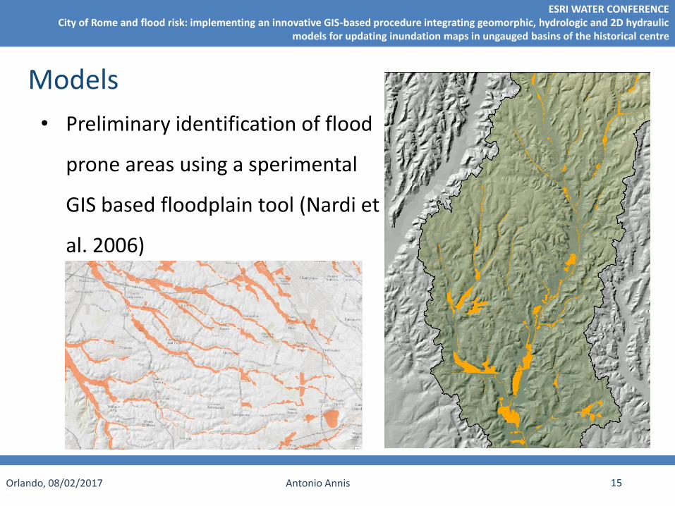
• Preliminary identification of flood
prone areas using a sperimental
GIS based floodplain tool (Nardi et
al. 2006)
Models
Orlando, 08/02/2017 Antonio Annis
ESRI WATER CONFERENCECity of Rome and flood risk: implementing an innovative GIS-based procedure integrating geomorphic, hydrologic and 2D hydraulic
models for updating inundation maps in ungauged basins of the historical centre
16
Models: floodplain model
Nardi F., Vivoni E. R., Grimaldi S. (WRR, 2006)
River network geomorphic propertiesClimatic conditions (Rainfall)
Local hydrogeomorphic propertiesOf the floodplain (fluvial) cross section
ℎ = 𝑎𝐴b
Orlando, 08/02/2017 Antonio Annis
ESRI WATER CONFERENCECity of Rome and flood risk: implementing an innovative GIS-based procedure integrating geomorphic, hydrologic and 2D hydraulic
models for updating inundation maps in ungauged basins of the historical centre
17
Models
Simplified 1D-2D hydraulic modelling using:
1. trapezoidal channel geometry at the beginning2. Step by step inserting surveyed cross sections
Orlando, 08/02/2017 Antonio Annis
ESRI WATER CONFERENCECity of Rome and flood risk: implementing an innovative GIS-based procedure integrating geomorphic, hydrologic and 2D hydraulic
models for updating inundation maps in ungauged basins of the historical centre
18
Models• Postprocessing of 2D hydraulic results using high resolution DEM
Orlando, 08/02/2017 Antonio Annis
ESRI WATER CONFERENCECity of Rome and flood risk: implementing an innovative GIS-based procedure integrating geomorphic, hydrologic and 2D hydraulic
models for updating inundation maps in ungauged basins of the historical centre
19
Methodology
Hydrologicmodelling
Floodmaps comparison
S 1 S 3S 2
Si=Bridges/cross sections scenarios
Ri=1D-2D results
Mi=Post processed floodmaps
… Sn
1D-2D hydraulicmodelling
R 1 R 3R 2 … Rn
Flow depthprocessing
M 1 M 3M 2 … Mn
Critical Bridges-culverts
identifications
Topographicsurvey plan
Iteration 1 : n scenarios
Iteration 2 : n - 1k scenarios
Iteration 3 : n - 2k scenarios
….
Orlando, 08/02/2017 Antonio Annis
ESRI WATER CONFERENCECity of Rome and flood risk: implementing an innovative GIS-based procedure integrating geomorphic, hydrologic and 2D hydraulic
models for updating inundation maps in ungauged basins of the historical centre
20
Methodology
Optimizing available digital data and efficiently planning additional topographic surveying by means of GIS to support the development of hydrologic and hydraulic models
GIS
Hydrologicmodelling
2D Hydraulicmodelling
Postprocessingof Flow depths
with Lidar
Analysis of critical issues
Topographicsurvey plan
Terrain anlaysisDigital
floodplainmorphology
Orlando, 08/02/2017 Antonio Annis
ESRI WATER CONFERENCECity of Rome and flood risk: implementing an innovative GIS-based procedure integrating geomorphic, hydrologic and 2D hydraulic
models for updating inundation maps in ungauged basins of the historical centre
21
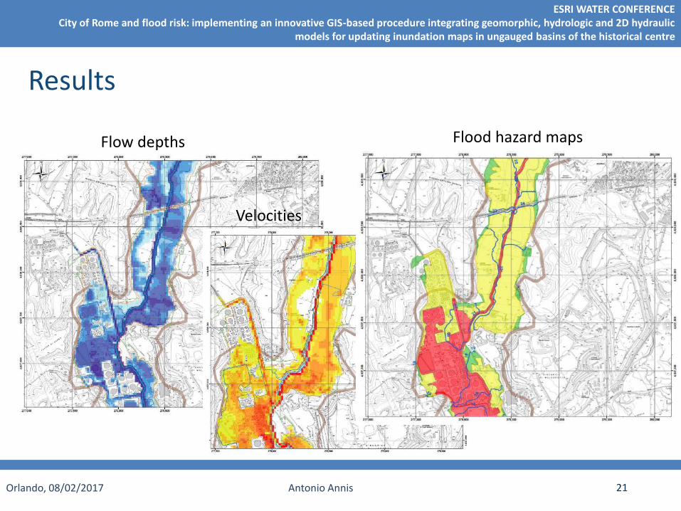
Results
Flood hazard mapsFlow depths
Velocities
Orlando, 08/02/2017 Antonio Annis
ESRI WATER CONFERENCECity of Rome and flood risk: implementing an innovative GIS-based procedure integrating geomorphic, hydrologic and 2D hydraulic
models for updating inundation maps in ungauged basins of the historical centre
22
Conclusions
Complex urban systems at flood risk require a big amount ofsurveys in order to define the topography for an accuratehydraulic model
GIS-based terrain analysis can give a preliminary idea of themost critical zones, pointing flood prone areas and culvertswith the most critical combination of contributing area and unithydrograph response (WF) of the upstream watershed
The innovative procedure for optimizing the surveying planningallowed to produce flood maps of an area of more than 1,000km2 with limited time and budget
Orlando, 08/02/2017 Antonio Annis
ESRI WATER CONFERENCECity of Rome and flood risk: implementing an innovative GIS-based procedure integrating geomorphic, hydrologic and 2D hydraulic
models for updating inundation maps in ungauged basins of the historical centre