80
City of Saint Paul CAPITAL CITY BIKEWAY: NETWORK STUDY AND DESIGN GUIDE

City of Saint PaulCAPITAL CITY BIKEWAY:NETWORK STUDY AND DESIGN GUIDE
CAPITAL CITY BIKEWAY: NETWORK STUDY AND DESIGN GUIDE ii
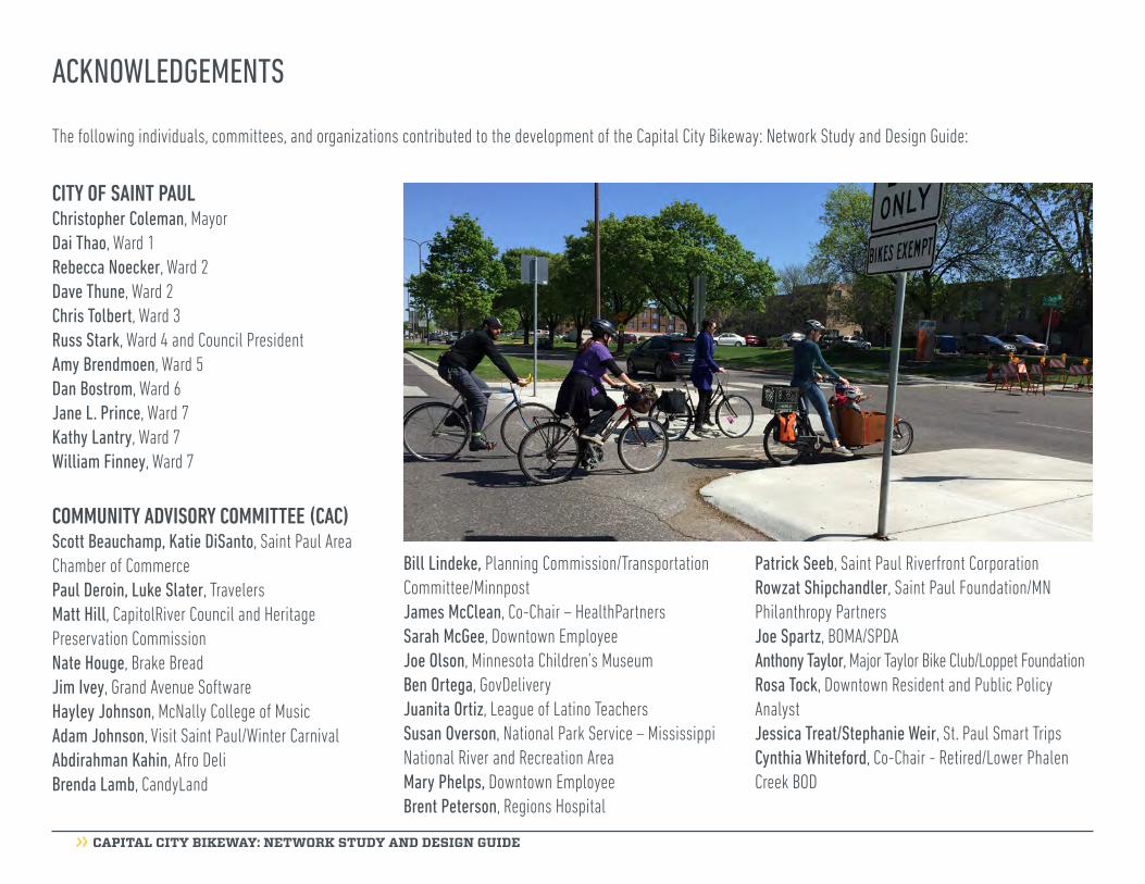
ACKNOWLEDGEMENTS
CITY OF SAINT PAULChristopher Coleman, MayorDai Thao, Ward 1Rebecca Noecker, Ward 2Dave Thune, Ward 2 Chris Tolbert, Ward 3Russ Stark, Ward 4 and Council PresidentAmy Brendmoen, Ward 5Dan Bostrom, Ward 6Jane L. Prince, Ward 7Kathy Lantry, Ward 7William Finney, Ward 7
COMMUNITY ADVISORY COMMITTEE (CAC) Scott Beauchamp, Katie DiSanto, Saint Paul Area Chamber of CommercePaul Deroin, Luke Slater, TravelersMatt Hill, CapitolRiver Council and Heritage Preservation CommissionNate Houge, Brake BreadJim Ivey, Grand Avenue SoftwareHayley Johnson, McNally College of MusicAdam Johnson, Visit Saint Paul/Winter CarnivalAbdirahman Kahin, Afro Deli Brenda Lamb, CandyLand
Bill Lindeke, Planning Commission/Transportation Committee/MinnpostJames McClean, Co-Chair – HealthPartners Sarah McGee, Downtown EmployeeJoe Olson, Minnesota Children’s MuseumBen Ortega, GovDeliveryJuanita Ortiz, League of Latino TeachersSusan Overson, National Park Service – Mississippi National River and Recreation AreaMary Phelps, Downtown EmployeeBrent Peterson, Regions Hospital
Patrick Seeb, Saint Paul Riverfront CorporationRowzat Shipchandler, Saint Paul Foundation/MN Philanthropy PartnersJoe Spartz, BOMA/SPDAAnthony Taylor, Major Taylor Bike Club/Loppet FoundationRosa Tock, Downtown Resident and Public Policy AnalystJessica Treat/Stephanie Weir, St. Paul Smart TripsCynthia Whiteford, Co-Chair - Retired/Lower Phalen Creek BOD
The following individuals, committees, and organizations contributed to the development of the Capital City Bikeway: Network Study and Design Guide:
CAPITAL CITY BIKEWAY: NETWORK STUDY AND DESIGN GUIDE iii
CORE MANAGEMENT TEAMKevin Nelson, Public WorksReuben Collins, Public WorksAnton Jerve, Planning & Economic Development
POLICY ADVISORY COMMITTEE (PAC) Donna Drummond, Planning Director, Planning & Economic DevelopmentDan Haak, Street Design Manager, Public WorksMike Hahm, Director, Parks & RecreationAnne Hunt, Environmental Policy Director, Mayor’s OfficePaul Kurtz, City Engineer, Public WorksKathy Lantry, Director, Public WorksJohn Maczko, Traffic Engineer, Public WorksJody Martinez, Design Manager, Parks & RecreationJonathan Sage-Martinson, Director, Planning & Economic DevelopmentPaul St. Martin, Transportation Planning & Safety Manager, Public Works
TECHNICAL ADVISORY COMMITTEE (TAC) Christine Boulware, Planning and Economic Development, Heritage Preservation Anna Eleria, Capitol Region Watershed District Brett Hussong, Parks and Recreation, Design
Zach Jorgenson, Parks and Recreation, ForestryAlice Messer, Parks and Recreation, DesignPat Murphy, Public Works, SewersMark Riegel, Public Works, Planning & SafetyNora Riemenschneider, Planning and Economic Development, 8 80 InitiativeWes Saunders-Pearce, Safety & Inspection, Water ResourcesLucy Thompson, Planning and Economic Development, Downtown PlanningHunWen Westman, Public Works, TrafficMarcus Young, Public Works, Public Art
CONSULTANT TEAMToole Design GroupSEH Little Cornejo ConsultingLandscape ResearchMyklebust + Sears
This Guide was completed in 2016.

CAPITAL CITY BIKEWAY: NETWORK STUDY AND DESIGN GUIDE iv

CAPITAL CITY BIKEWAY: NETWORK STUDY AND DESIGN GUIDE v
NOTE FROM THE MAYOR
Saint Paul is committed to creating vibrant places and spaces throughout the City, which is extremely evident in the creation of the Capital City Bikeway: Network and Design Guide.
The Capital City Bikeway is a blueprint for a system of off-street bicycle and pedestrian trails in downtown Saint Paul that connect residents and visitors to downtown attractions and the existing regional trail network, including the Gateway State Trail and the Samuel H. Morgan Regional Trail. When the bikeway is fully built, the majority of downtown Saint Paul will be within two or three blocks of the route.
This Guide is the result of great work by our project partners, including the Community Advisory Committee and members of the community. Together we have crafted a world-class standard for bikeway design that will usher in a new era of streets – streets that accommodate all users of the system, no matter their mode, age or ability.
I am thankful for this community’s continued dedication and involvement as we have worked toward new initiatives like this one. It is because of your support and passion that we can make changes that benefit all in Saint Paul.
See you on the Bikeway!
Sincerely,
Mayor Chris Coleman

CAPITAL CITY BIKEWAY: NETWORK STUDY AND DESIGN GUIDE vi
this page intentionally blank
CAPITAL CITY BIKEWAY: NETWORK STUDY AND DESIGN GUIDE vii
TABLE OF CONTENTS
EXECUTIVE SUMMARY..................................................viii
INTRODUCTION AND BACKGROUND.............................01
COMMUNITY ENGAGEMENT PROCESS.........................02 Community Advisory Committee (CAC) Discovery Workshop Design Workshop Pop-Up Events
BIKEWAY NETWORK STUDY..........................................04 Capital City Bikeway Network Map Jackson Street Bikeway Location on Jackson Street 9th Street/ 10th Street Street Alternatives Bikeway Location on 9th Street/10th Street St. Peter Street Street Alternatives Bikeway Location on St. Peter Street Kellogg Boulevard and 4th Street Market District Street Alternatives Bikeway Location on Kellogg Boulevard
BIKEWAY DESIGN GUIDE............................................17 Capital City Bikeway Design Guidelines Capital City Bikeway Experience Design Approach Logos and Identity Hardscape Palette Landscape Palette Public Art Overview of Considerations Public Art Guidelines Public Art Implementation
BIKEWAY IMPLEMENTATION PLAN........48 Major Bikeways Jackson Street 9th Street / 10th Street St. Peter Street Kellogg Boulevard Minor Bikeways Minnesota Street Washington Street Wacouta Street 4th Street Market District Phasing Plan and Cost Estimates
APPENDICES Appendix A: Discovery Workshop Summary Appendix B: Design Workshop Summary Appendix C: Design Standards Appendix D: Historic Resources Summary Report Appendix E: Conceptual Design Plans Appendix F: Summary Report: 4th Street Market District

CAPITAL CITY BIKEWAY: NETWORK STUDY AND DESIGN GUIDE viii
EXECUTIVE SUMMARY
Initiated by the City of Saint Paul Bicycle Plan and funded by the 8 80 Vitality Initiative, the Capital City Bikeway is poised to become a world-class network of bikeways in the heart of downtown Saint Paul. The goal of the Capital City Bikeway: Network Study and Design Guide (Guide) is to establish a network of bicycle facilities in the core of downtown that encourages bicycle ridership and economic development.
When implemented, the Capital City Bikeway will not only make bicycling safer for people of all ages and abilities in Saint Paul, but it will positively contribute to the overall experience and vitality of the City.
The Guide recommends routes and alignments for the downtown network based on community preference surveys and technical analyses of each proposed
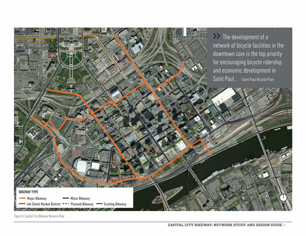
route. The resulting network of major and minor routes will provide great access to the many businesses and institutions downtown (Figure A). The primary routes include:
» Jackson Street » 9th Street /10th Street » St. Peter Street » Kellogg Boulevard
These routes fill a critical gap in the Saint Paul bicycle network and the regional trail system. The table below highlights the recommended routes, bikeway type, extents and location within the right-of-way.
The Guide provides direction on the elements of the Capital City Bikeway, including:
» Bikeway design » Branding
» Street furniture » Wayfinding » Landscaping » Public art
It draws from state of the art bikeway design and the Saint Paul Street Design Manual. The distinguishing feature of the Capital City Bikeway is a trail that is separated from motor vehicles and pedestrians by landscaped or paved buffers at sidewalk level. Minor routes feature on street bicycle facilities, buffered by striping and flexible posts.
The following chapters provide detailed information on the process, analyses, and design recommendations.
Street Bikeway type Route extents Location within right-of-way
Jackson Street Major University Avenue to Kellogg Boulevard West side
9th Street/10th Street Major History Center driveway to Broadway Street
South side west of Cedar on 10thNorth side east of Cedar on 10thSouth side east of Jackson Street
St. Peter Street Major John Ireland Boulevard to Kellogg Boulevard West side
Kellogg Boulevard Major John Ireland Boulevard to Sibley Street North side
Minnesota Street Minor 10th Street to Kellogg Boulevard West side
Wacouta Street Minor 9th Street to Kellogg Boulevard TBD
Market Street Minor St. Peter Street to Kellogg Boulevard TBD
4th Street TBD Washington Street to Broadway Street TBD
Street Bikeway type Route extents Location along the street
CAPITAL CITY BIKEWAY: NETWORK STUDY AND DESIGN GUIDE ix
NMajor Bikeway4th Street Market District Existing BikewayPlanned Bikeway
BIKEWAY TYPE
Minor Bikeway
Minnesota Street
Wabasha Street
Broadway
Street
St. Peter Street
Kellogg Boulevard
Cedar Street
Jackson Street
Robert StreetWa
shin
gton
Stre
et
US Highway 52
9th Street
4th Street
Prince Street
Kellogg Boulevard
Samuel H. Morgan Regional Trail
10th Street
10th Street
John
Irelan
d Bou
levard
Wacouta StreetTrout Brook Regional Trail
Charles Avenue
Bruce Vento Regional TrailPa
rk S
treee
t
University Avenue
The development of a network of bicycle facilities in the downtown core is the top priority for encouraging bicycle ridership and economic development in Saint Paul. - Saint Paul Bicycle Plan
Figure A: Capital City Bikeway Network Map.

CAPITAL CITY BIKEWAY: NETWORK STUDY AND DESIGN GUIDE x

CAPITAL CITY BIKEWAY: NETWORK STUDY AND DESIGN GUIDE 1
In 2014, the City of Saint Paul established a “Vibrant Places and Spaces” vision, further illustrating its commitment to being the Most Livable City in America. At the core “Vibrant Places and Spaces” is about creating a wonderful public realm that is accessible and enjoyable for people of all ages, backgrounds, and abilities. Designing great streets that are safe and comfortable for all modes is just one way Saint Paul is investing in people, it’s economy, and its future.
Between 2011-2015, the City of Saint Paul (City) developed its current bicycle plan, adopted by the City Council in March 2015 as an addendum to the City’s Comprehensive Plan. The Saint Paul Bicycle Plan establishes a framework for the City to accomplish the bicycling goals identified in the Comprehensive Plan: increase the mode share of bicycling and establish a network of bikeways throughout the city.
The Guide was born out of the Saint Paul Bicycle Plan and identified in Chapter 6.0 (Expanding the Bicycle Network) as part of the City’s planned bicycle network. The primary objective of the City’s planned bicycle network is to provide safe and comfortable places for people of all ages and abilities to ride a bicycle. Section 9.5 of the Bicycle Plan states that
“the development of a network of bicycle facilities in the downtown core is the top priority for encouraging bicycle ridership and economic development in Saint Paul”.
The objectives of the Guide are to: 1) determine the best routes for the downtown bikeway network; 2) determine potential connections to downtown from the broader regional bikeway system; 3) develop initial design concepts for the recommended bikeway network alignments; and 4) implement the first phase of the downtown bikeway network by designing and constructing a two-way protected bikeway on Jackson Street from 11th Street to Shepard Road. The broader goals of the project are to help enhance the vitality of downtown, improve the prospects for continued economic development, and make downtown a more attractive place for all.
The project will create a transformational change to downtown Saint Paul by encouraging activity in the streets, enhancing the vitality of sidewalks and public spaces, and stimulating investment and fostering economic development. The Capital City Bikeway is modeled off of the Indianapolis Cultural Trail, which saw an increase of $1 billion in property values within
one block of the trail between 2008 and 2014.1 Locally, the Midtown Greenway in the City of Minneapolis sparked $200 million in residential development after 5.5 miles of protected bikeway were built. “Per acre, the apartment buildings along the Greenway generate more than six times the tax revenue of big-box developments nearby.”2
Providing high quality infrastructure improvements along the Capital City Bikeway will provide great opportunities for development by local business owners and an increase in local spending within downtown Saint Paul, similar to other cities around the country who have made these investments.
This document provides information on developing the Capital City Bikeway network, and design guidance for immediate implementation of interim bikeway treatments and the phased implementation of the ultimate Capital City Bikeway vision through street and bridge reconstruction.
INTRODUCTION AND BACKGROUND
1. http://indyculturaltrail.org.s3.amazonaws.com/wp-content/uploads/2015/07/15-C02-CulturalTrail-Assessment.pdf 2. Fisher, Thomas, “Streetscapes: Midtown Greenway spurs urban development, especially in Uptown”, http://m.startribune.com/variety/303081591.html?section=/

CAPITAL CITY BIKEWAY: NETWORK STUDY AND DESIGN GUIDE 2
The City met with community groups, business owners, property owners, and the broader public throughout the duration of the project. Community engagement included two week-long workshops, two online surveys, pop-up events, and monthly meetings with the project’s community advisory committee (CAC), technical advisory committee (TAC) comprised of city staff, and policy advisory committee (PAC) comprised of city staff leadership. The input gathered from these engagement efforts helped inform this Guide and the design of Jackson Street, which is being reconstructed in 2016-2017.
Community Advisory Committee (CAC)A community advisory committee (CAC) was appointed by the Mayor in early May 2015. The committee consists of 26 individuals who live and/or work downtown, represent downtown businesses, or represent community groups in Saint Paul. The CAC met throughout the planning and design process to discuss bikeway route alternatives, bikeway design elements, and brand identity.
Discovery WorkshopA four day “discovery workshop” was held in May 2015. The purpose of the workshop was to hear from stakeholders, community members, and City staff regarding the desires, concerns, likes, and dislikes related to establishing a downtown bikeway network.
The workshop week began with a site tour of the possible alignments of the Capital City Bikeway and was followed by a facilitated public workshop. The workshop included background information about the project, project goals, objectives, scope, and schedule. Workshop attendees participated in a small group activity focused on identifying desires, needs, and concerns.
The design team held individual stakeholder interviews with community leaders, downtown business/property owners, cultural institution representatives, local organizations, City staff, and elected officials. Information from these interviews helped to create
criteria to evaluate alignment alternatives for the downtown bikeway network and create starter ideas for what may be possible along the alternative bikeway routes. An online survey supplemented the community input received on the materials and starter ideas presented at the discovery workshop.
A comprehensive summary of the discovery workshop, can be found in Appendix A.
Design WorkshopIn June 2015, the City facilitated a four day design workshop. The purpose of the workshop was to work with stakeholders to refine the Capital City Bikeway
COMMUNITY ENGAGEMENT PROCESS

CAPITAL CITY BIKEWAY: NETWORK STUDY AND DESIGN GUIDE 3
network, and generate initial design concepts and layouts for the Capital City Bikeway routes and the Jackson Street reconstruction project. Conceptual designs were developed for Jackson Street, Kellogg Boulevard, St. Peter Street, and 9th Street/10th Street. The design team emphasized the design and analysis of Jackson Street since it is the first segment of the Capital City Bikeway to be built.
The design team hosted “open studio” hours for the public, CAC, TAC, PAC and City staff to provide input and react to the designs. In addition, focus group meetings were held between City staff, stakeholders and the design team. Focus group meeting topics included
urban design, stormwater management, traffic, public art, and historic and cultural resources.
On the final day of the design workshop, the design team prepared preliminary design concepts and bikeway alignment recommendations to share with the community at an evening public open house. At the event, community members were able to interact with staff and share their reactions to concept layouts for Jackson Street and Kellogg Boulevard, public art, paving, plantings, and branding.
A more comprehensive summary of the design workshop can be found in Appendix B.
COMMUNITY ENGAGEMENT PROCESS
Pop-Up EventsThe design team held four pop-up events to gather additional input on the project. Events were held at Mears Park, Pedro Park, and Rondo Days, including a bike ride at Rondo Days with the NiceRide Neighborhood Group and Major Taylor Bicycling Club. During the pop-up events participants provided input on the project including suggestions for the name of the bikeway, location of the bikeway routes, and how the City could encourage more people to bike.
CAPITAL CITY BIKEWAY: NETWORK STUDY AND DESIGN GUIDE 4
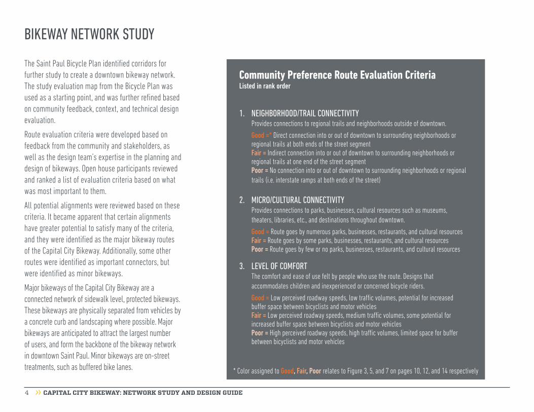
The Saint Paul Bicycle Plan identified corridors for further study to create a downtown bikeway network. The study evaluation map from the Bicycle Plan was used as a starting point, and was further refined based on community feedback, context, and technical design evaluation.
Route evaluation criteria were developed based on feedback from the community and stakeholders, as well as the design team’s expertise in the planning and design of bikeways. Open house participants reviewed and ranked a list of evaluation criteria based on what was most important to them.
All potential alignments were reviewed based on these criteria. It became apparent that certain alignments have greater potential to satisfy many of the criteria, and they were identified as the major bikeway routes of the Capital City Bikeway. Additionally, some other routes were identified as important connectors, but were identified as minor bikeways.
Major bikeways of the Capital City Bikeway are a connected network of sidewalk level, protected bikeways. These bikeways are physically separated from vehicles by a concrete curb and landscaping where possible. Major bikeways are anticipated to attract the largest number of users, and form the backbone of the bikeway network in downtown Saint Paul. Minor bikeways are on-street treatments, such as buffered bike lanes.
BIKEWAY NETWORK STUDY
Community Preference Route Evaluation CriteriaListed in rank order
* Color assigned to Good, Fair, Poor relates to Figure 3, 5, and 7 on pages 10, 12, and 14 respectively
1. NEIGHBORHOOD/TRAIL CONNECTIVITYProvides connections to regional trails and neighborhoods outside of downtown.
Good =* Direct connection into or out of downtown to surrounding neighborhoods or regional trails at both ends of the street segmentFair = Indirect connection into or out of downtown to surrounding neighborhoods or regional trails at one end of the street segmentPoor = No connection into or out of downtown to surrounding neighborhoods or regional trails (i.e. interstate ramps at both ends of the street)
2. MICRO/CULTURAL CONNECTIVITYProvides connections to parks, businesses, cultural resources such as museums, theaters, libraries, etc., and destinations throughout downtown.
Good = Route goes by numerous parks, businesses, restaurants, and cultural resourcesFair = Route goes by some parks, businesses, restaurants, and cultural resourcesPoor = Route goes by few or no parks, businesses, restaurants, and cultural resources
3. LEVEL OF COMFORTThe comfort and ease of use felt by people who use the route. Designs that accommodates children and inexperienced or concerned bicycle riders.
Good = Low perceived roadway speeds, low traffic volumes, potential for increased buffer space between bicyclists and motor vehiclesFair = Low perceived roadway speeds, medium traffic volumes, some potential for increased buffer space between bicyclists and motor vehiclesPoor = High perceived roadway speeds, high traffic volumes, limited space for buffer between bicyclists and motor vehicles

CAPITAL CITY BIKEWAY: NETWORK STUDY AND DESIGN GUIDE 5
Community Preference Route Evaluation Criteria (continued)
BIKEWAY NETWORK STUDY
4. LEGIBILITY & WAYFINDING The route is straight, easy to find, and easy to navigate. Provides appropriate wayfinding signs and branding.
Good = Direct route, few crossings from one side of the street to anotherFair = Fairly direct route, some crossings from one side of the street to anotherPoor = Indirect, not intuitive route, numerous crossings from one side of the street to another
5. TRANSIT CONFLICTSBikeway route could conflict with transit loading and unloading.
Good = No transit conflictsFair = Some transit conflicts Poor = Numerous transit conflicts
6. PLACEMAKING OPPORTUNITIESOpportunities to provide new public spaces potentially with grass, trees, or other
vegetation.
Good = Numerous wide buffer and pedestrian zone widths to add landscaping and street furnishings, and existing buildings set back from existing right-of-wayFair = Some wide buffer and pedestrian zone widths to add landscaping and street furnishings, existing buildings set back from existing right-of-wayPoor = Few or no wide buffer and pedestrian zone widths to add landscaping and street furnishings, and existing building set back from existing right-of-way
7. ECONOMIC DEVELOPMENT POTENTIALRoutes located along existing businesses and areas available for redevelopment.
Good = Numerous existing surface lots (redevelopment potential), buildings set back from existing right-of-way, street level access, and street level retail businesses or restaurants
Fair = Some existing surface lots (redevelopment potential), buildings set back from existing right-of-way, street level access, and street level retail businesses or restaurantsPoor = Few or no existing surface lots (redevelopment potential), buildings set back from existing right-of-way, street level access, and street level retail businesses or
restaurants
8. PRESERVE ON-STREET PARKINGMaintain as much on-street parking as possible, maximize the number and presence of on-street parking spaces.
Good = Most or all on-street parking preservedFair = Some on-street parking preserved
Poor = No on-street parking preserved
9. CONTROL OF RIGHT-OF-WAYThe City of Saint Paul owns the right-of-way needed to construct a bikeway.
Good = City of Saint Paul owns all of the right-of-wayFair = City of Saint Paul owns a majority of the right-of-way
Poor = City of Saint Paul owns little to no right-of-way
10. HISTORIC SITES & REQUIREMENTSProximity to historic sites, districts, and impacts on those districts from the routes.
Information only.
11. TRAFFIC VOLUMESExisting traffic volumes along the route.
Good = Less than 7,000 motor vehicles per dayFair = 7,000 to 10,000 motor vehicles per dayPoor = Greater than 10,000 motor vehicles per day
CAPITAL CITY BIKEWAY: NETWORK STUDY AND DESIGN GUIDE 6
BIKEWAY NETWORK STUDY
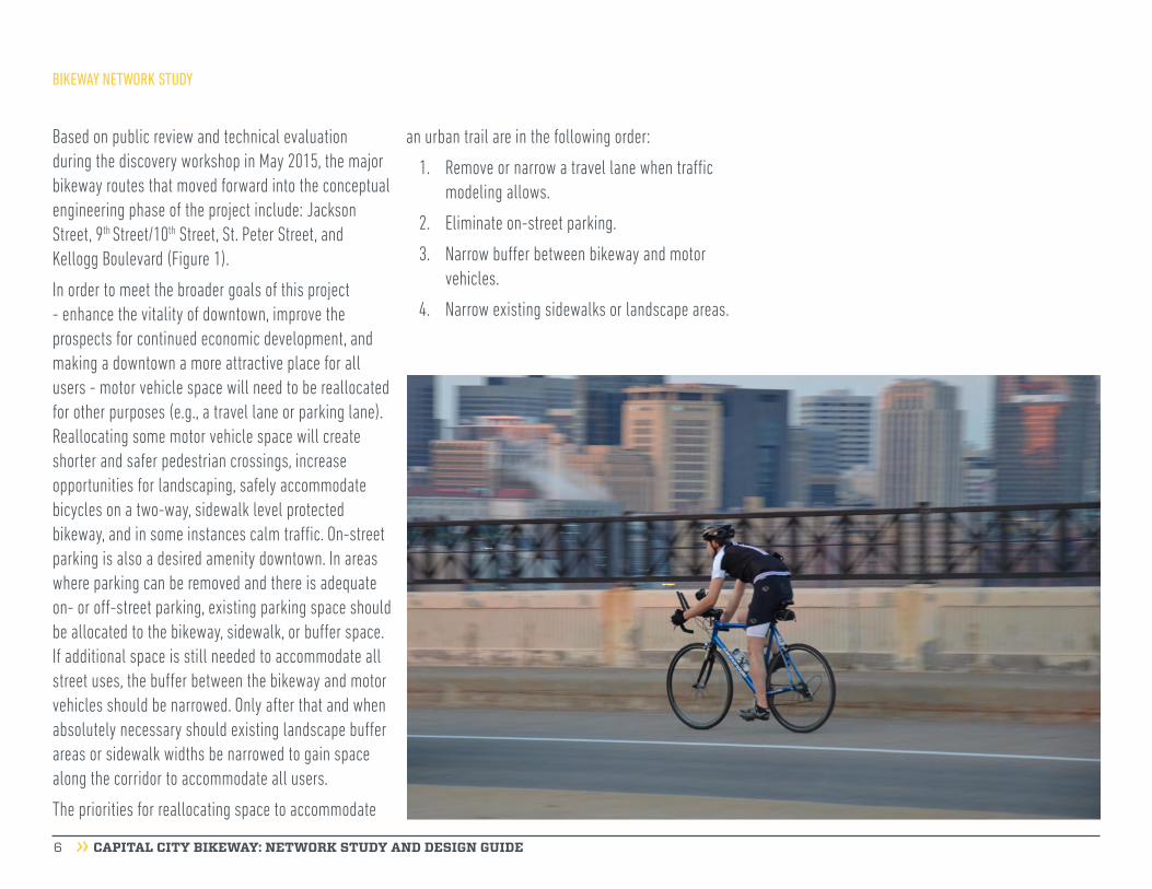
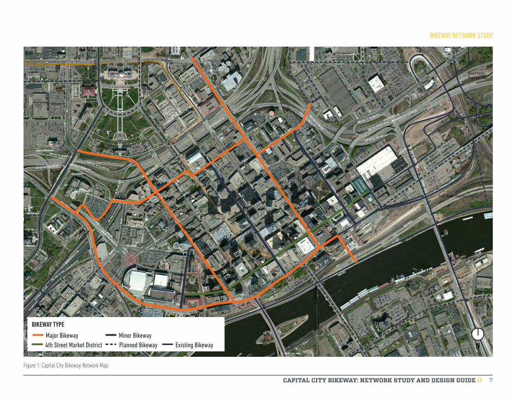
Based on public review and technical evaluation during the discovery workshop in May 2015, the major bikeway routes that moved forward into the conceptual engineering phase of the project include: Jackson Street, 9th Street/10th Street, St. Peter Street, and Kellogg Boulevard (Figure 1).
In order to meet the broader goals of this project - enhance the vitality of downtown, improve the prospects for continued economic development, and making a downtown a more attractive place for all users - motor vehicle space will need to be reallocated for other purposes (e.g., a travel lane or parking lane). Reallocating some motor vehicle space will create shorter and safer pedestrian crossings, increase opportunities for landscaping, safely accommodate bicycles on a two-way, sidewalk level protected bikeway, and in some instances calm traffic. On-street parking is also a desired amenity downtown. In areas where parking can be removed and there is adequate on- or off-street parking, existing parking space should be allocated to the bikeway, sidewalk, or buffer space. If additional space is still needed to accommodate all street uses, the buffer between the bikeway and motor vehicles should be narrowed. Only after that and when absolutely necessary should existing landscape buffer areas or sidewalk widths be narrowed to gain space along the corridor to accommodate all users.
The priorities for reallocating space to accommodate
an urban trail are in the following order:
1. Remove or narrow a travel lane when traffic modeling allows.
2. Eliminate on-street parking.
3. Narrow buffer between bikeway and motor vehicles.
4. Narrow existing sidewalks or landscape areas.
CAPITAL CITY BIKEWAY: NETWORK STUDY AND DESIGN GUIDE 7
NMajor Bikeway4th Street Market District Existing BikewayPlanned Bikeway
BIKEWAY TYPE
Minor Bikeway
Minnesota Street
Wabasha Street
Broadway
Street
St. Peter Street
Kellogg Boulevard
Cedar Street
Jackson Street
Robert StreetWa
shin
gton
Stre
et
US Highway 52
9th Street
4th Street
Prince Street
Kellogg Boulevard
Samuel H. Morgan Regional Trail
10th Street
10th Street
John
Irelan
d Bou
levard
Wacouta StreetTrout Brook Regional Trail
Charles Avenue
Bruce Vento Regional TrailPa
rk S
treee
t
University Avenue
Figure 1: Capital City Bikeway Network Map.
BIKEWAY NETWORK STUDY

CAPITAL CITY BIKEWAY: NETWORK STUDY AND DESIGN GUIDE 8
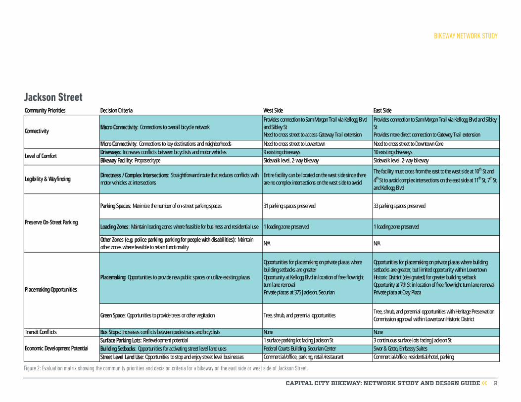
Jackson StreetThe Saint Paul Bicycle Plan identified Jackson Street as the first segment of the Capital City Bikeway to be implemented because it was a high priority segment for street reconstruction and connects the Gateway State Trail to the Samuel Morgan Regional Trail. In addition to Jackson Street, the bikeway will be constructed on a one block segment of Kellogg Boulevard between Jackson Street and Sibley Street, and on Sibley Street from Kellogg Boulevard to Warner Road. Reconstruction of Jackson Street began in summer 2016 and is scheduled to be completed in 2017.
Bikeway Location on Jackson StreetThe bikeway will be on the west side of Jackson Street between 11th Street and Kellogg Boulevard. The Saint Paul Bicycle Plan recommended the bikeway on the west side of the street, and the community engagement and technical analysis confirmed that the west side is the most suitable location for the bikeway.
Figure 2 shows the evaluation of community priorities and decision criteria for a bikeway on the west side and the east side of Jackson Street.
Existing conditions on Jackson Street.
BIKEWAY NETWORK STUDY
CAPITAL CITY BIKEWAY: NETWORK STUDY AND DESIGN GUIDE 9
Community Priorities Decision Criteria West Side East Side
Macro Connectivity: Connections to overall bicycle network
Provides connection to Sam Morgan Trail via Kellogg Blvd
and Sibley St
Need to cross street to access Gateway Trail extension
Provides connection to Sam Morgan Trail via Kellogg Blvd and Sibley
St
Provides more direct connection to Gateway Trail extension
Micro Connectivity: Connections to key destinations and neighborhoods Need to cross street to Lowertown Need to cross street to Downtown Core
Driveways: Increases conflicts between bicyclists and motor vehicles 9 existing driveways 10 existing driveways
Bikeway Facility: Proposed type Sidewalk level, 2-way bikeway Sidewalk level, 2-way bikeway
Legibility & WayfindingDirectness / Complex Intersections: Straightforward route that reduces conflicts with
motor vehicles at intersections
Entire facility can be located on the west side since there
are no complex intersections on the west side to avoid
The facility must cross from the east to the west side at 10th St and
4th St to avoid complex intersections on the east side at 11th St, 7th St,
and Kellogg Blvd
Parking Spaces: Maximize the number of on-street parking spaces 31 parking spaces preserved 33 parking spaces preserved
Loading Zones: Maintain loading zones where feasible for business and residential use 1 loading zone preserved 1 loading zone preserved
Other Zones (e.g. police parking, parking for people with disabilities): Maintain
other zones where feasible to retain functionalityN/A N/A
Placemaking: Opportunities to provide new public spaces or utilize existing plazas
Opportunities for placemaking on private plazas where
building setbacks are greater
Opportunity at Kellogg Blvd in location of free flow right
turn lane removal
Private plazas at 375 Jackson, Securian
Opportunities for placemaking on private plazas where building
setbacks are greater, but limited opportunity within Lowertown
Historic District (designated) for greater building setback
Opportunity at 7th St in location of free flow right turn lane removal
Private plaza at Cray Plaza
Green Space: Opportunities to provide trees or other vegitation Tree, shrub, and perennial opportunitiesTree, shrub, and perennial opportunities with Heritage Preservation
Commission approval within Lowertown Historic District
Transit Conflicts Bus Stops: Increases conflicts between pedestrians and bicyclists None None
Surface Parking Lots: Redevelopment potential 1 surface parking lot facing Jackson St 3 continuous surface lots facing Jackson St
Building Setbacks: Opportunities for activating street level land uses Federal Courts Building, Securian Center Swor & Gatto, Embassy Suites
Street Level Land Use: Opportunities to stop and enjoy street level businesses Commercial/office, parking, retail/restaurant Commercial/office, residential/hotel, parking
Economic Development Potential
Preserve On-Street Parking
Connectivity
Level of Comfort
Placemaking Opportunities
Figure 2: Evaluation matrix showing the community priorities and decision criteria for a bikeway on the east side or west side of Jackson Street.
BIKEWAY NETWORK STUDY
Jackson Street

CAPITAL CITY BIKEWAY: NETWORK STUDY AND DESIGN GUIDE 10
Street AlternativesThree alternatives for the east-west bikeway segment on the north side of downtown were analyzed and considered: 9th Street/Exchange Street, 10th Street, and 11th Street. Figure 3 describes some of the impacts, differences, pros, and cons of each option. A description of each route evaluation criteria is provided on pages 4-5. The recommended route alignment is a combination of 9th Street/10th Street. This route was chosen due to higher comfort level, the
greatest economic development potential, and better connectivity.
The bikeway is recommended to begin from the west at Mulberry Street and Kellogg Boulevard, head east through the Minnesota History Center along the parking lot, connecting to 10th Street. The bikeway is recommended to remain on 10th Street to Jackson Street, then moves one block south, continuing east on 9th Street. The bikeway would cross the 9th Street Bridge over I-94 and then connect to the planned bike lanes on Broadway Street.
Bikeway Location on 9th Street/10th Street
The bikeway along 9th Street/10th Street is recommended to be located primarily on the south side of the street.
Figure 4 compares various community priorities and decision criteria* for a bikeway on the north side and the south side of 9th Street/10th Street.
The bikeway along 9th Street/10th Street will largely be located on the south side of the street. It will begin on the south side of 10th Street between the History Center
Evaluation Criteria 10th Street 11th Street 9th Street/Exchange Street
Neighborhood/Trail Connectivity Yes No Yes
Micro/Cultural Connectivity Yes No Yes
Level of Comfort High Low High
Legibility/Wayfinding Medium High Low
Transit Conflicts No No No
Placemaking Opportunities Yes Yes Yes
Economic Development Potential Existing Long-Term Short-Term
Preserve On-Street Parking No Limited No
Control of Right-of-Way No (History Center, History Theatre) No (N Side) No
Historic Sites & Requirements NoneCapitol Area Architectural and
Planning Board approval neededNone
Traffic Volumes (2014 MnDOT) 4,200-6,600 8,500-10,600 1,650-2,200
Figure 3: Evaluation criteria for determining which street(s) to locate the bikeway.
9th Street / 10th Street
Good Fair Poor Information Only*Described in detail on page 4-5
BIKEWAY NETWORK STUDY

CAPITAL CITY BIKEWAY: NETWORK STUDY AND DESIGN GUIDE 11
Community Priorities Decision Criteria North Side South Side
Macro Connectivity: Connections to overall bicycle network Provides connection to Jackson St and St. Peter St bikeways Provides connection to Jackson St and St. Peter St bikeways
Micro Connectivity: Connections to key destinations and neighborhoods Need to cross street to downtown core Need to cross street to Capitol Area
West of Cedar St: 9 existing driveways (2 hospital access, 1 large
parking ramp)
West of Cedar St: 6 existing driveways (1 ambulance/ emergency
room access)
Cedar St to Jackson St: 8 existing driveways (3 fire station
driveways)Cedar St to Jackson St: 7 existing driveways
East of Jackson St: 4 existing driveways East of Jackson St: 5 existing driveways
Bikeway Facility: Proposed type Sidewalk level, 2-way bikeway Sidewalk level, 2-way bikeway
Legibility & WayfindingDirectness / Complex Intersections: Straightforward route that reduces conflicts with
motor vehicles at intersectionsMore conflicts with 10th St/Cedar St intersection and LRT station Fewer conflicts with 10th St/Cedar St intersection and LRT station
Parking Spaces: Maximize the number of on-street parking spaces No parking spaces preserved No parking spaces preserved
Loading Zones: Maintain loading zones where feasible for business and residential use No loading zones preserved No loading zones preserved
Other Zones (e.g. police parking, parking for people with disabilities): Maintain
other zones where feasible to retain functionalityN/A N/A
Placemaking: Opportunities to provide new public spaces or utilize existing plazas
More existing plazas
Private plazas at St. Joseph's Hospital, Ramsey County Public
Health Building, Elmer L. Anderson Human Services Building, The
Penfield, Lund's
More existing parks
Private plaza at History Theatre
Green Space: Opportunities to provide trees or other vegitation Limited width for green space Limited width for green space
Transit Conflicts Bus Stops: Increases conflicts between pedestrians and bicyclistsExisting stop at NE corner of 10th St/Cedar St, relocate to the north
along Cedar StNo existing bus stops
Surface Parking Lots: Redevelopment potential 3 surface parking lots 4 surface parking lots
Building Setbacks: Opportunities for activating street level land usesRamsey County Public Health Center, Elmer L. Anderson Human
Services Building, Penfield Apartments, Lund's groceryGallery Tower Apartments, The History Theater, Pedro Park
Street Level Land Use: Opportunities to stop and enjoy street level businesses Civil/cultural/institutional, residential/hotel, retail/restaurantCivil/cultural/institutional, park/plaza/courtyard, parking,
residential/hotel
Economic Development Potential
Placemaking Opportunities
Connectivity
Level of ComfortDriveways: Increases conflicts between bicyclists and motor vehicles
Preserve-On Street Parking
Figure 4: Evaluation matrix showing the community priorities and decision criteria for a bikeway on the north side and the south side of 9th Street and 10th Street.
and Cedar Street to create a connection to the History Center parking lot without crossing the road. To the east of Cedar Street, the bikeway is recommended to be located on the north side of 10th Street until Jackson
Street to better accommodate fire truck access in and out of the fire station located on the north side of 10th Street. The bikeway would then connect with the Jackson Street bikeway for one block, and continue
east on 9th Street on the south side of the roadway, reducing conflicts with motor vehicles accessing the I-35E on ramp at Broadway Street, and providing easier access for bicyclists to Wacouta Commons Park.
BIKEWAY NETWORK STUDY
9th Street / 10th Street
CAPITAL CITY BIKEWAY: NETWORK STUDY AND DESIGN GUIDE 12
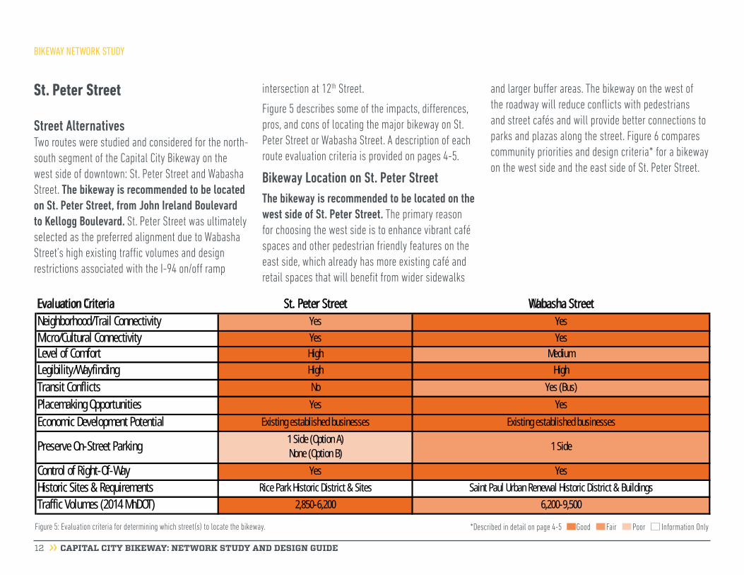
Street AlternativesTwo routes were studied and considered for the north-south segment of the Capital City Bikeway on the west side of downtown: St. Peter Street and Wabasha Street. The bikeway is recommended to be located on St. Peter Street, from John Ireland Boulevard to Kellogg Boulevard. St. Peter Street was ultimately selected as the preferred alignment due to Wabasha Street’s high existing traffic volumes and design restrictions associated with the I-94 on/off ramp
intersection at 12th Street.
Figure 5 describes some of the impacts, differences, pros, and cons of locating the major bikeway on St. Peter Street or Wabasha Street. A description of each route evaluation criteria is provided on pages 4-5.
Bikeway Location on St. Peter StreetThe bikeway is recommended to be located on the west side of St. Peter Street. The primary reason for choosing the west side is to enhance vibrant café spaces and other pedestrian friendly features on the east side, which already has more existing café and retail spaces that will benefit from wider sidewalks
and larger buffer areas. The bikeway on the west of the roadway will reduce conflicts with pedestrians and street cafés and will provide better connections to parks and plazas along the street. Figure 6 compares community priorities and design criteria* for a bikeway on the west side and the east side of St. Peter Street.
Evaluation Criteria St. Peter Street Wabasha Street
Neighborhood/Trail Connectivity Yes Yes
Micro/Cultural Connectivity Yes Yes
Level of Comfort High Medium
Legibility/Wayfinding High High
Transit Conflicts No Yes (Bus)
Placemaking Opportunities Yes Yes
Economic Development Potential Existing established businesses Existing established businesses
Preserve On-Street Parking1 Side (Option A)
None (Option B)1 Side
Control of Right-Of-Way Yes Yes
Historic Sites & Requirements Rice Park Historic District & Sites Saint Paul Urban Renewal Historic District & Buildings
Traffic Volumes (2014 MnDOT) 2,850-6,200 6,200-9,500
Figure 5: Evaluation criteria for determining which street(s) to locate the bikeway.
St. Peter Street
Good Fair Poor Information Only*Described in detail on page 4-5
BIKEWAY NETWORK STUDY

CAPITAL CITY BIKEWAY: NETWORK STUDY AND DESIGN GUIDE 13
Community Priorities Decision Criteria West Side East Side
Macro Connectivity: Connections to overall bicycle network Provides connection to north side of downtown coreProvides connection to north side of downtown core
Awkward connection to John Ireland Boulevard
Micro Connectivity: Connections to key destinations and neighborhoods th St
Ramsey County Courthouse/Saint Paul City Hall, Juvenile & Family
Kincaids, Meritage, Great Waters
Driveways: Increases conflicts between bicyclists and motor vehicles 3 existing driveways 5 existing driveways
Legibility & WayfindingDirectness / Complex Intersections: Straightforward route that reduces conflicts with
motor vehicles at intersectionsEntire faciliity can be located n the west side
Entire facility can be located on the east side
Sight lines may be of concern
Option A: 45 parking spaces preserved Option A: 65 parking spaces preserved
Option B: No parking spaces preserved Option B: No parking spaces preserved
Loading Zones: Maintain loading zones where feasible for business and residential use 2 loading zones preserved No loading zones preserved
Other Zones (e.g. police parking, parking for people with disabilities): Maintain
other zones where feasible to retain functionality
1 hospital loading zone preserved
1 police parking zone preserved
1 hospital loading zone preserved
No police parking zone preserved
Green Space: Opportunities to provide trees or other vegitationGreater building setbacks
Café space has opportunity for landscaping Street cafés limit available width
Transit Conflicts Bus Stops: Increases conflicts between pedestrians and bicyclists None None
Surface Parking Lots: Redevelopment potential 1 surface parking lot No surface parking lots
Building Setbacks: Opportunities for activating street level land usesSt. Joseph's Hospital, Hamm Plaza, EcoLab, Landmark Plaza,
Landmark TowersSt. Paul Public Housing Agency, Ramsey County Courthouse
Street Level Land Use: Opportunities to stop and enjoy street level businesses
Civil/cultural/institution, commercial/office, park/plaza/courtyard,
Opportunity to retain existing and add additional street café space
on east side of road
Retail/restaurant, civic/cultural/institutional
Economic Development Potential
Parking Spaces: Maximize the number of on-street parking spaces
Limited opportunity within Capitol Area District
Private plazas at State Public Housing Agency, Gallery Building,
Ramsey County Juvenile & Family Justice Center, 7th Place,
Lawson Commons
Sidewalk level, 2-way bikeway
Connectivity
Level of ComfortBikeway Facility: Proposed type Sidewalk level, 2-way bikeway
Placemaking Opportunities
Placemaking: Opportunities to provide new public spaces or utilize existing plazas
Opportunities for placemaking on private and public plazas where
building setbacks are greater
Opportunity to retain existing and add additional street café space
on east side of road
Private plazas at St. Joseph's Hospital, EcoLab Plaza, Landmark
Towers, Wold Building
Public plaza at Hamm Plaza
Preserve On-Street Parking
Figure 6: Evaluation matrix showing the community priorities and decision criteria for a bikeway on the west side and the east side of St. Peter Street.
BIKEWAY NETWORK STUDY
St. Peter Street

CAPITAL CITY BIKEWAY: NETWORK STUDY AND DESIGN GUIDE 14
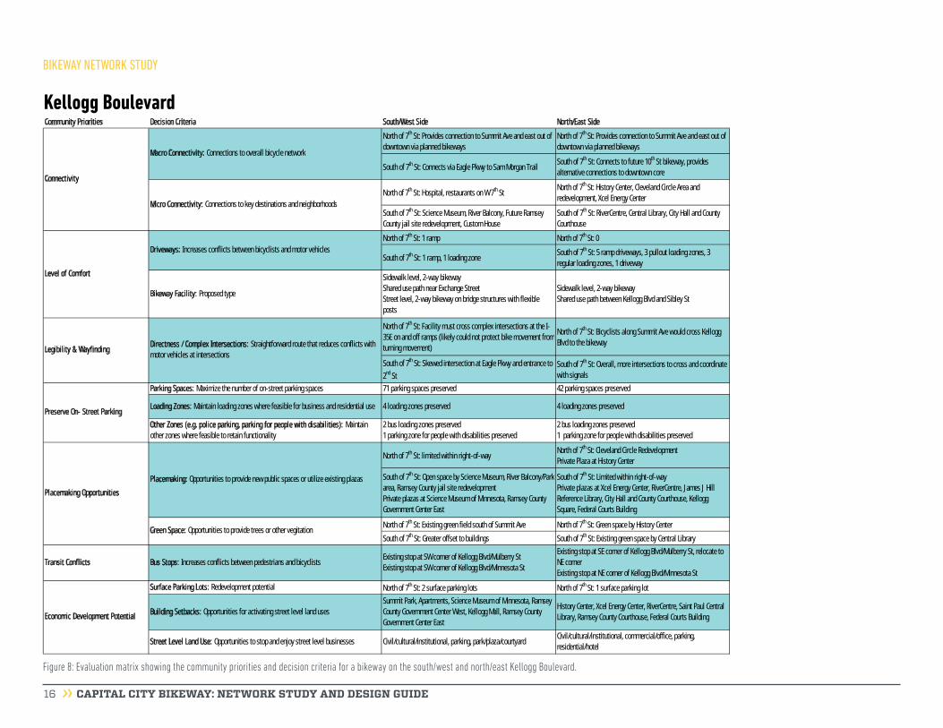
Street AlternativesKellogg Boulevard is the recommended east-west bikeway segment on the south side of downtown. The bikeway is recommended to follow Kellogg Boulevard from John Ireland Boulevard to Sibley Street.
Along with Kellogg Boulevard, the design team also analyzed 4th and 5th Streets as potential streets for the major bikeway. The option of locating the bikeway on 5th Street was eliminated due to existing transit conflicts, daily traffic volumes, and a lower level of comfort. Figure 7 describes some of the impacts, differences, pros, and cons of locating the major bikeway on Kellogg Boulevard, 4th Street, or 5th Street. A
description of each route evaluation criteria is provided on pages 4-5.
Bikeway Location on Kellogg BoulevardThe feasibility of locating the bikeway on the north/east and south/west sides of Kellogg Boulevard were evaluated. A two-way protected bikeway on the south side was evaluated due to the proximity of the Science
Evaluation Criteria Kellogg Boulevard 4th Street 5th Street
Neighborhood/Trail Connectivity Yes Yes Yes
Micro/Cultural Connectivity Yes Yes Yes
Level of Comfort Medium High Medium
Legibility/Wayfinding High High Medium
Transit Conflicts No Yes (LRT) Yes (Bus)
Placemaking Opportunities Yes Yes Maybe
Economic Development Potential Short and Long-Term Short-Term Short-Term
Preserve On-Street Parking 1 Side Future Study Needed 1 Side
Control of Right-of-Way
Yes - North side
Right-of-way needed for fully protected
facility on south side
Yes Yes
Historic Sites & Requirements
Rice Park Historic District, Saint Paul Urban
Renewal Historic District, Lowertown Historic
District & Buildings
Rice Park Historic District, Saint
Paul Urban Renewal Historic
District, Lowertown Historic
District & Buildings
Rice Park Historic District, Saint
Paul Urban Renewal Historic
District, & Lowertown Historic
District
Traffic Volumes (2014 MnDOT) 16,200-26,700 1,700-2,250 3,650-16,000
Figure 7: Evaluation criteria for determining which street(s) to locate the bikeway.
Kellogg Boulevard & 4th Street Market District
Good Fair Poor Information Only*Described in detail on page 4-5
BIKEWAY NETWORK STUDY

CAPITAL CITY BIKEWAY: NETWORK STUDY AND DESIGN GUIDE 15
Museum of Minnesota and Kellogg Mall Park. However, pinch points due to the bridge structures limit the ability to provide a continuous two-way sidewalk level bikeway similar to the rest of the Capital City Bikeway network. Additionally, modifying bridge structures to increase the right-of-way width is impractical.
Because of the significant challenges related to locating the bikeway on the south side of Kellogg Boulevard, a north side, two-way protected bikeway concept from 7th Street to Jackson Street was developed. A north side protected bikeway has more street crossings; however, it also allows for a wider bikeway, additional green space (depending on existing utilities), and separated bicycle and pedestrian facilities along the majority of the corridor. It connects to the shared trail segment of the Capital City Bikeway on the north side of Kellogg Boulevard at Jackson Street. After reviewing both options, the recommendation is to locate the bikeway on the east/north side of Kellogg Boulevard.
Figure 8 compares various community priorities and design criteria* for a bikeway on the west/south side versus the east/north side of Kellogg Boulevard.
4th Street Market District4th Street is recommended to be a significant biking and walking corridor in downtown that will complement the Capital City Bikeway. Public preference
was split between 4th Street and Kellogg Boulevard. Implementing both routes is recommended, though each will have a distinct character. Establishing a working team is recommended to further develop the 4th Street Market District concept. Additional study is needed on 4th Street to evaluate operations, parking ramp access, and potential impacts of future rail alignments. The vision for 4th Street is a “shared street” between transit, bicyclists, pedestrians, and motor vehicles. The concept of a shared street emerged
during the discovery workshop in May 2015, and local business owners led a visioning process to explore the idea and published the results in November 2015. More information on the conceptual design recommendation for 4th Street is described in the Implementation Plan section. Figure 7 describes some of the impacts, differences, pros, and cons between locating the bikeway on Kellogg Boulevard, 4th Street, and 5th Street.
Existing conditions on Kellogg Boulevard.
BIKEWAY NETWORK STUDY
CAPITAL CITY BIKEWAY: NETWORK STUDY AND DESIGN GUIDE 16
Figure 8: Evaluation matrix showing the community priorities and decision criteria for a bikeway on the south/west and north/east Kellogg Boulevard.
Community Priorities Decision Criteria South/West Side North/East Side
North of 7th St: Provides connection to Summit Ave and east out of
downtown via planned bikeways
North of 7th St: Provides connection to Summit Ave and east out of
downtown via planned bikeways
South of 7th St: Connects via Eagle Pkwy to Sam Morgan TrailSouth of 7th St: Connects to future 10th St bikeway, provides
alternative connections to downtown core
North of 7th St: Hospital, restaurants on W 7th StNorth of 7th St: History Center, Cleveland Circle Area and
redevelopment, Xcel Energy Center
South of 7th St: Science Museum, River Balcony, Future Ramsey
County jail site redevelopment, Custom House
South of 7th St: RiverCentre, Central Library, City Hall and County
Courthouse
North of 7th St: 1 ramp North of 7th St: 0
South of 7th St: 1 ramp, 1 loading zoneSouth of 7th St: 5 ramp driveways, 3 pullout loading zones, 3
regular loading zones, 1 driveway
Bikeway Facility: Proposed type
Sidewalk level, 2-way bikeway
Shared use path near Exchange Street
Street level, 2-way bikeway on bridge structures with flexible
posts
Sidewalk level, 2-way bikeway
Shared use path between Kellogg Blvd and Sibley St
North of 7th St: Facility must cross complex intersections at the I-
35E on and off ramps (likely could not protect bike movement from
turning movement)
North of 7th St: Bicyclists along Summit Ave would cross Kellogg
Blvd to the bikeway
South of 7th St: Skewed intersection at Eagle Pkwy and entrance to
2nd St
South of 7th St: Overall, more intersections to cross and coordinate
with signals
Parking Spaces: Maximize the number of on-street parking spaces 71 parking spaces preserved 42 parking spaces preserved
Loading Zones: Maintain loading zones where feasible for business and residential use 4 loading zones preserved 4 loading zones preserved
Other Zones (e.g. police parking, parking for people with disabilities): Maintain
other zones where feasible to retain functionality
2 bus loading zones preserved
1 parking zone for people with disabilities preserved
2 bus loading zones preserved
1 parking zone for people with disabilities preserved
North of 7th St: limited within right-of-wayNorth of 7th St: Cleveland Circle Redevelopment
Private Plaza at History Center
South of 7th St: Open space by Science Museum, River Balcony/Park
area, Ramsey County jail site redevelopment
Private plazas at Science Museum of Minnesota, Ramsey County
Government Center East
South of 7th St: Limited within right-of-way
Private plazas at Xcel Energy Center, RiverCentre, James J Hill
Reference Library, City Hall and County Courthouse, Kellogg
Square, Federal Courts Building
North of 7th St: Existing green field south of Summit Ave North of 7th St: Green space by History Center
South of 7th St: Greater offset to buildings South of 7th St: Existing green space by Central Library
Transit Conflicts Bus Stops: Increases conflicts between pedestrians and bicyclistsExisting stop at SW corner of Kellogg Blvd/Mulberry St
Existing stop at SW corner of Kellogg Blvd/Minnesota St
Existing stop at SE corner of Kellogg Blvd/Mulberry St, relocate to
NE corner
Existing stop at NE corner of Kellogg Blvd/Minnesota St
Surface Parking Lots: Redevelopment potential North of 7th St: 2 surface parking lots North of 7th St: 1 surface parking lot
Building Setbacks: Opportunities for activating street level land uses
Summit Park, Apartments, Science Museum of Minnesota, Ramsey
County Government Center West, Kellogg Mall, Ramsey County
Government Center East
History Center, Xcel Energy Center, RiverCentre, Saint Paul Central
Library, Ramsey County Courthouse, Federal Courts Building
Street Level Land Use: Opportunities to stop and enjoy street level businesses Civil/cultural/institutional, parking, park/plaza/courtyardCivil/cultural/institutional, commercial/office, parking,
residential/hotel
Economic Development Potential
Legibility & WayfindingDirectness / Complex Intersections: Straightforward route that reduces conflicts with
motor vehicles at intersections
Preserve On- Street Parking
Level of Comfort
Driveways: Increases conflicts between bicyclists and motor vehicles
Placemaking Opportunities
Placemaking: Opportunities to provide new public spaces or utilize existing plazas
Green Space: Opportunities to provide trees or other vegitation
Connectivity
Micro Connectivity: Connections to key destinations and neighborhoods
Macro Connectivity: Connections to overall bicycle network
BIKEWAY NETWORK STUDY
Kellogg Boulevard

CAPITAL CITY BIKEWAY: NETWORK STUDY AND DESIGN GUIDE 17
This section provides guidance for the design and implementation of the Capital City Bikeway.
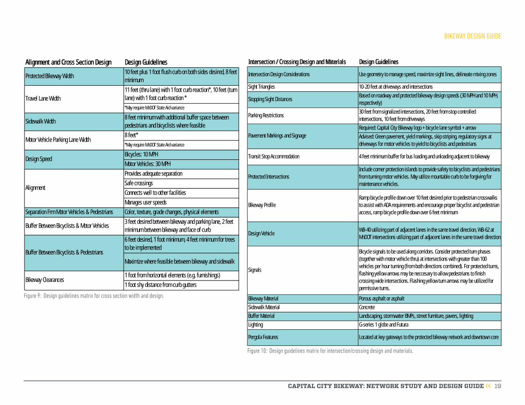
Capital City Bikeway Design GuidelinesThere are national guidelines, statewide guidelines, and local guidelines that need to be accounted for in the overall design of a street corridor. All of the streets being considered for the Capital City Bikeway are currently Minnesota Department of Transportation (MnDOT) Municipal State Aid (MSA) routes with minimum dimension requirements that may only be modified by obtaining a variance.
The Saint Paul Street Design Manual, MnDOT State Aid Manual, MnDOT Bikeway Facility Design Manual, MN Manual on Uniform Traffic Control Devices (MN MUTCD), American Association of State Highway and Transportation Officials (AASHTO) Guide for the Development of Bicycle Facilities, National Association of City Transportation Officials (NACTO) Urban Bikeway
Design Guide, Massachusetts DOT Separated Bike Lane Planning and Design Guide provided minimum and recommended design guidance for the Capital City Bikeway. In general, the minimum dimensions outlined in these documents provide basic function and safety.
Many of these design guidelines and minimum requirements are recommendations rather than
BIKEWAY DESIGN GUIDE

CAPITAL CITY BIKEWAY: NETWORK STUDY AND DESIGN GUIDE 18
requirements. Increasing bike lane widths, sidewalk widths, and buffer widths will provide more comfortable facilities for all users.
The following figures provide the recommended design guidelines for the Capital City Bikeway. Engineering judgment should be used in all scenarios, decision making documented, and proper design exceptions obtained from appropriate oversight agencies if dimensions less than the recommended design guidelines are chosen. Additional information on the recommended design guidelines for the Capital City Bikeway are in Appendix C.
BIKEWAY DESIGN GUIDE
CAPITAL CITY BIKEWAY: NETWORK STUDY AND DESIGN GUIDE 19
BIKEWAY DESIGN GUIDE
Alignment and Cross Section Design Design Guidelines
Protected Bikeway Width10 feet plus 1 foot flush curb on both sides desired, 8 feet
minimum
11 feet (thru lane) with 1 foot curb reaction*, 10 feet (turn
lane) with 1 foot curb reaction *
*May require MnDOT State Aid variance
Sidewalk Width8 feet minimum with additional buffer space between
pedestrians and bicyclists where feasible
8 feet*
*May require MnDOT State Aid variance
Bicycles: 10 MPH
Motor Vehicles: 30 MPH
Provides adequate separation
Safe crossings
Connects well to other facilities
Manages user speeds
Separation Frm Motor Vehicles & Pedestrians Color, texture, grade changes, physical elements
Buffer Between Bicyclists & Motor Vehicles3 feet desired between bikeway and parking lane, 2 feet
minimum between bikeway and face of curb
6 feet desired, 1 foot minimum, 4 feet minimum for trees
to be implemented
Maximize where feasible between bikeway and sidewalk
1 foot from horizontal elements (e.g. furnishings)
1 foot shy distance from curb gutters
Buffer Between Bicyclists & Pedestrians
Bikeway Clearances
Travel Lane Width
Motor Vehicle Parking Lane Width
Design Speed
Alignment
Figure 9: Design guidelines matrix for cross section width and design.
Figure 10: Design guidelines matrix for intersection/crossing design and materials.
Intersection / Crossing Design and Materials Design Guidelines
Intersection Design Considerations Use geometry to manage speed, maximize sight lines, delineate mixing zones
Sight Triangles 10-20 feet at driveways and intersections
Stopping Sight DistancesBased on roadway and protected bikeway design speeds (30 MPH and 10 MPH,
respectively)
Parking Restrictions 30 feet from signalized intersections, 20 feet from stop controlled
intersections, 10 feet from driveways
Required: Capital City Bikeway logo + bicycle lane symbol + arrow
Advised: Green pavement, yield markings, skip striping, regulatory signs at
driveways for motor vehicles to yield to bicyclists and pedestrians
Transit Stop Accommodation 4 feet minimum buffer for bus loading and unloading adjacent to bikeway
Protected Intersections
Include corner protection islands to provide safety to bicyclists and pedestrians
from turning motor vehicles. May utilize mountable curb to be forgiving for
maintenance vehicles.
Bikeway Profile
Ramp bicycle profile down over 10 feet desired prior to pedestrian crosswalks
to assist with ADA requirements and encourage proper bicyclist and pedestrian
access, ramp bicycle profile down over 6 feet minimum
Design VehicleWB-40 utilizing part of adjacent lanes in the same travel direction, WB-62 at
MnDOT intersections utilizing part of adjacent lanes in the same travel direction
Signals
Bicycle signals to be used along corridors. Consider protected turn phases
(together with motor vehicle thru) at intersections with greater than 100
vehicles per hour turning (from both directions combined). For protected turns,
flashing yellow arrows may be neccesary to allow pedestrians to finish
crossing wide intersections. Flashing yellow turn arrows may be utilized for
permissive turns.
Bikeway Material Porous asphalt or asphalt
Sidewalk Material Concrete
Buffer Material Landscaping, stormwater BMPs, street furniture, pavers, lighting
Lighting G-series 1 globe and Futura
Pergola Features Located at key gateways to the protected bikeway network and downtown core
Pavement Markings and Signage
CAPITAL CITY BIKEWAY: NETWORK STUDY AND DESIGN GUIDE 20
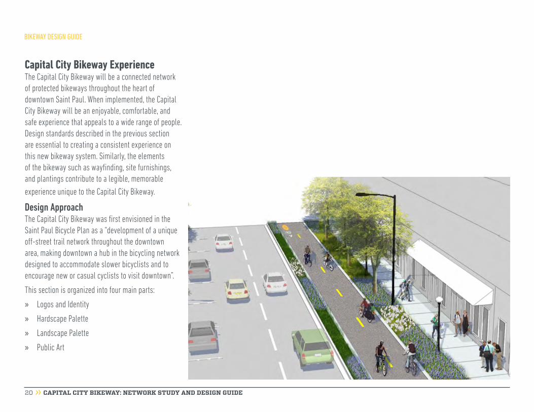
Capital City Bikeway ExperienceThe Capital City Bikeway will be a connected network of protected bikeways throughout the heart of downtown Saint Paul. When implemented, the Capital City Bikeway will be an enjoyable, comfortable, and safe experience that appeals to a wide range of people. Design standards described in the previous section are essential to creating a consistent experience on this new bikeway system. Similarly, the elements of the bikeway such as wayfinding, site furnishings, and plantings contribute to a legible, memorable experience unique to the Capital City Bikeway.
Design ApproachThe Capital City Bikeway was first envisioned in the Saint Paul Bicycle Plan as a “development of a unique off-street trail network throughout the downtown area, making downtown a hub in the bicycling network designed to accommodate slower bicyclists and to encourage new or casual cyclists to visit downtown”.
This section is organized into four main parts:
» Logos and Identity
» Hardscape Palette
» Landscape Palette
» Public Art
BIKEWAY DESIGN GUIDE
CAPITAL CITY BIKEWAY: NETWORK STUDY AND DESIGN GUIDE 21
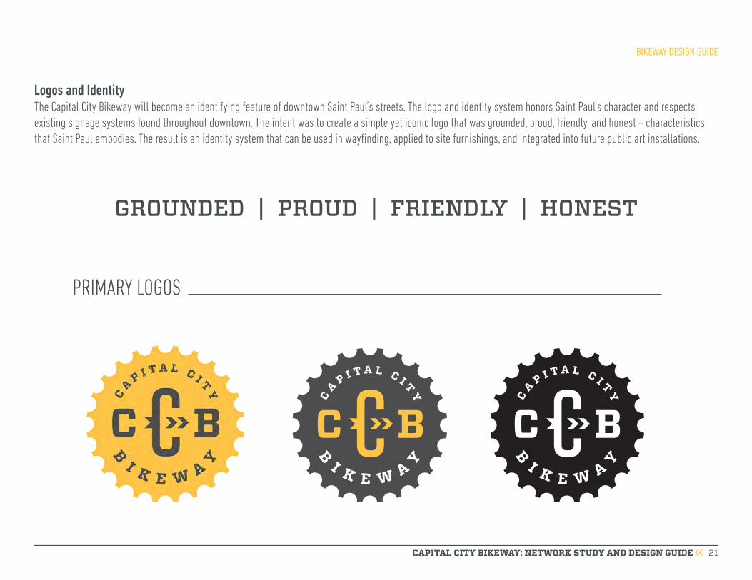
Logos and IdentityThe Capital City Bikeway will become an identifying feature of downtown Saint Paul’s streets. The logo and identity system honors Saint Paul’s character and respects existing signage systems found throughout downtown. The intent was to create a simple yet iconic logo that was grounded, proud, friendly, and honest – characteristics that Saint Paul embodies. The result is an identity system that can be used in wayfinding, applied to site furnishings, and integrated into future public art installations.
PRIMARY LOGOS
GROUNDED | PROUD | FRIENDLY | HONEST
BIKEWAY DESIGN GUIDE

CAPITAL CITY BIKEWAY: NETWORK STUDY AND DESIGN GUIDE 22
R E V E R S E D
B I K E W A YC A P I T A L C I T Y
B I K E W A YC A P I T A L C I T Y
SECONDARY LOGOS
BIKEWAY DESIGN GUIDE

PA N TO N E # 7 5 4 0C MYK
PA N TO N E # 2 1 8 8
- 4 1- 2 8 - 2 5- 6 5
PA N TO N E # 1 2 3C MYK
- 0- 1 9 - 8 9- 0
P R O C E S S B L AC KC MYK
- 0- 0 - 0- 1 0 0
P R O C E S S W H I T EC MYK
- 0- 0 - 0- 0
( F O R U S E I N AC C E N T S F O R B R A N D E D M AT E R I A L S W H E N A P P R O P R I AT E )
PA N TO N E # 6 2 9 PA N TO N E # 1 5 9 PA N TO N E # 2 2 8 0
CAPITAL CITY BIKEWAY: NETWORK STUDY AND DESIGN GUIDE 23
PRIMARY COLORS
SECONDARY COLORS
FOR USE IN PRIMARY BRAND APPLICATIONS: ANNOUNCEMENTS, POSTERS, SIGNAGE. YELLOW WITH GRAY IS TO BE USED FOR PRIMARY LOGO MARK IN SIGNAGE.
COMPLEMENTARY COLORS: USE FOR MAPS OR SMALLER ELEMENTS WHEN CALL-OUTS ARE NEEDED
BIKEWAY DESIGN GUIDE
P R O C E S S W H I T E
( D I S P L AY T Y P E , LO G O & H E A D L I N E U S E )
VITESSE BOLD
ABCDEFGHIJKLMNOPQRSTUVWXYZabcdefghijklmnopqrstuvwxyz1234567890.,&?!
D I N N E X T LT P R O C O N D E N S E D
A B C D E F G H I J K L M N O P Q R ST U V W X Y Za b c d e f g h i j k l m n o p q rs t u v w x y z1 2 3 4 5 6 7 8 9 0 . , & ? !
( B O DY C O P Y & D E S C R I P TO R U S E )
CAPITAL CITY BIKEWAY: NETWORK STUDY AND DESIGN GUIDE 24
PRIMARY FONT
SECONDARY FONT
BIKEWAY DESIGN GUIDE
CAPITAL CITY BIKEWAY: NETWORK STUDY AND DESIGN GUIDE 25
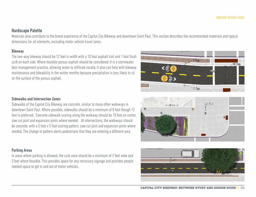
Hardscape PaletteMaterials also contribute to the brand experience of the Capital City Bikeway and downtown Saint Paul. This section describes the recommended materials and typical dimensions for all elements, excluding motor vehicle travel lanes.
BikewayThe two-way bikeway should be 12 feet in width with a 10 foot asphalt trail and 1 foot flush curb on each side. Where feasible porous asphalt should be considered. It is a stormwater best management practice, allowing water to infiltrate locally. It also can help with bikeway maintenance and bikeability in the winter months because precipitation is less likely to sit on the surface of the porous asphalt.
Sidewalks and Intersection Zones Sidewalks of the Capital City Bikeway are concrete, similar to many other walkways in downtown Saint Paul. Where possible, sidewalks should be a minimum of 8 feet though 12 feet is preferred. Concrete sidewalk scoring along the walkway should be 10 feet on center, saw cut joint and expansion joints where needed. At intersections, the walkways should be concrete, with a 5 foot x 5 foot scoring pattern, saw cut joint and expansion joints where needed. The change in pattern alerts pedestrians that they are entering a different area.
10’ o.c. 5’5’
10’ Typ. 1’ Typ.
1’ Typ.
3’
Parking AreasIn areas where parking is allowed, the curb zone should be a minimum of 2 feet wide and 3 feet where feasible. This provides space for any necessary signage and provides people needed space to get in and out of motor vehicles.
BIKEWAY DESIGN GUIDE
Tighter corner radii Curb extension minimizes pedestrian exposure
Corner protection islands
Bicyclists/pedestrians highly visible to drivers
CAPITAL CITY BIKEWAY: NETWORK STUDY AND DESIGN GUIDE 26
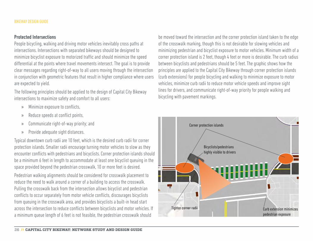
Protected IntersectionsPeople bicycling, walking and driving motor vehicles inevitably cross paths at intersections. Intersections with separated bikeways should be designed to minimize bicyclist exposure to motorized traffic and should minimize the speed differential at the points where travel movements intersect. The goal is to provide clear messages regarding right-of-way to all users moving through the intersection in conjunction with geometric features that result in higher compliance where users are expected to yield.
The following principles should be applied to the design of Capital City Bikeway intersections to maximize safety and comfort to all users:
» Minimize exposure to conflicts,
» Reduce speeds at conflict points,
» Communicate right-of-way priority; and
» Provide adequate sight distances.
Typical downtown curb radii are 10 feet, which is the desired curb radii for corner protection islands. Smaller radii encourage turning motor vehicles to slow as they encounter conflicts with pedestrians and bicyclists. Corner protection islands should be a minimum 6 feet in length to accommodate at least one bicyclist queuing in the space provided beyond the pedestrian crosswalk, 10 or more feet is desired.
Pedestrian walking alignments should be considered for crosswalk placement to reduce the need to walk around a corner of a building to access the crosswalk. Pulling the crosswalk back from the intersection allows bicyclist and pedestrian conflicts to occur separately from motor vehicle conflicts, discourages bicyclists from queuing in the crosswalk area, and provides bicyclists a built-in head start across the intersection to reduce conflicts between bicyclists and motor vehicles. If a minimum queue length of 6 feet is not feasible, the pedestrian crosswalk should
be moved toward the intersection and the corner protection island taken to the edge of the crosswalk marking, though this is not desirable for slowing vehicles and minimizing pedestrian and bicyclist exposure to motor vehicles. Minimum width of a corner protection island is 2 feet, though 4 feet or more is desirable. The curb radius between bicyclists and pedestrians should be 5 feet. The graphic shows how the principles are applied to the Capital City Bikeway through corner protection islands (curb extensions) for people bicycling and walking to minimize exposure to motor vehicles, minimize curb radii to reduce motor vehicle speeds and improve sight lines for drivers, and communicate right-of-way priority for people walking and bicycling with pavement markings.
BIKEWAY DESIGN GUIDE

CAPITAL CITY BIKEWAY: NETWORK STUDY AND DESIGN GUIDE 27
Victor Stanley Bench FBF-53
SeatingSeating is another element of the furnishing zone that helps define the space, and provides places for rest and gathering. Public seating should be provided at a minimum every ¼ mile along the corridor and adjacent to buildings with active street level land uses. The availability of existing seating areas should be considered in proposing new ones. For example, on Jackson Street, seating areas are provided between 11th Street and 10th Street, at 7th Street, at 7th Place, between 5th Street and 4th Street and near Kellogg Boulevard, a little less than ¼ mile apart. There is additional public seating between 4th and 5th near the 325 Jackson building. Careful attention to the materials and style of the benches adds to the user experience of the Capital City Bikeway. Benches may have backs or be backless. They should be large enough to comfortably sit two to three people. Six foot lengths should be considered where possible, with 4 foot lengths in constrained environments. The materials also need to be vandal proof, not easily scratched and easily cleaned. The Victor Stanley Streetsites collection FBF-53 provide both elegant design and functional materials for seating along the Capital City Bikeway. Skate inhibiting mounts are available. The backless bench allows people to sit facing the way they want.
Café SeatingTo accommodate a sidewalk café, the minimum frontage zone is 6 feet wide and the minimum boulevard/furnishing zone is 8 feet wide. Future segments of the Capital City Bikeway should include café seating where appropriate and feasible.
6’
8’ 6’
4’
2’ min
2’ min
BIKEWAY DESIGN GUIDE
CAPITAL CITY BIKEWAY: NETWORK STUDY AND DESIGN GUIDE 28
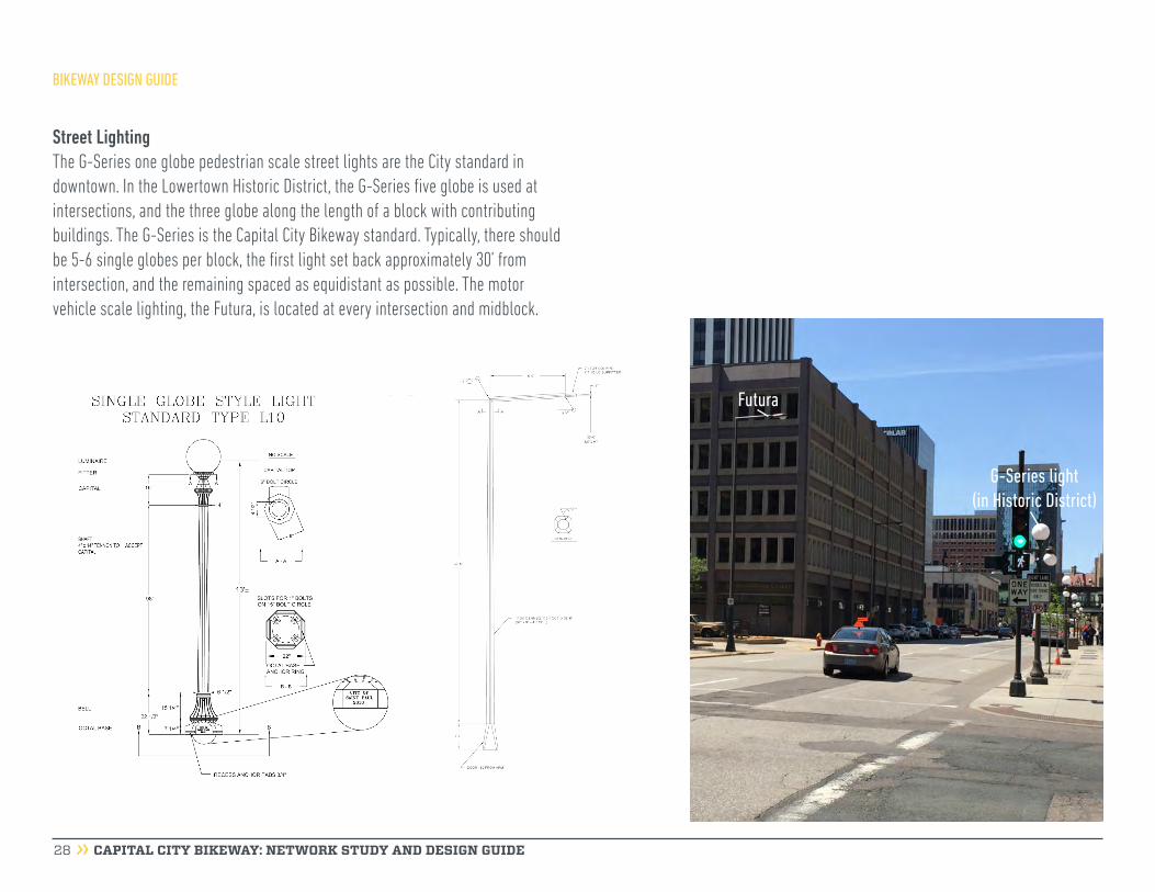
Street LightingThe G-Series one globe pedestrian scale street lights are the City standard in downtown. In the Lowertown Historic District, the G-Series five globe is used at intersections, and the three globe along the length of a block with contributing buildings. The G-Series is the Capital City Bikeway standard. Typically, there should be 5-6 single globes per block, the first light set back approximately 30’ from intersection, and the remaining spaced as equidistant as possible. The motor vehicle scale lighting, the Futura, is located at every intersection and midblock.
G-Series light (in Historic District)
Futura
BIKEWAY DESIGN GUIDE
CAPITAL CITY BIKEWAY: NETWORK STUDY AND DESIGN GUIDE 29
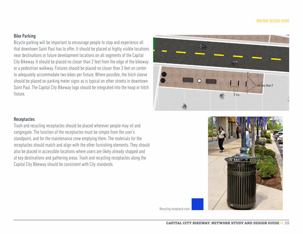
Bike ParkingBicycle parking will be important to encourage people to stop and experience all that downtown Saint Paul has to offer. It should be placed at highly visible locations near destinations or future development locations on all segments of the Capital City Bikeway. It should be placed no closer than 2 feet from the edge of the bikeway or a pedestrian walkway. Fixtures should be placed no closer than 3 feet on center to adequately accommodate two bikes per fixture. Where possible, the hitch sleeve should be placed on parking meter signs as is typical on other streets in downtown Saint Paul. The Capital City Bikeway logo should be integrated into the hoop or hitch fixture.
ReceptaclesTrash and recycling receptacles should be placed wherever people may sit and congregate. The function of the receptacles must be simple from the user’s standpoint, and for the maintenance crew emptying them. The materials for the receptacles should match and align with the other furnishing elements. They should also be placed in accessible locations where users are likely already stopped and at key destinations and gathering areas. Trash and recycling receptacles along the Capital City Bikeway should be consistent with City standards.
Recycling receptacle color
3’ o.c.
not less than 2’
BIKEWAY DESIGN GUIDE
CAPITAL CITY BIKEWAY: NETWORK STUDY AND DESIGN GUIDE 30
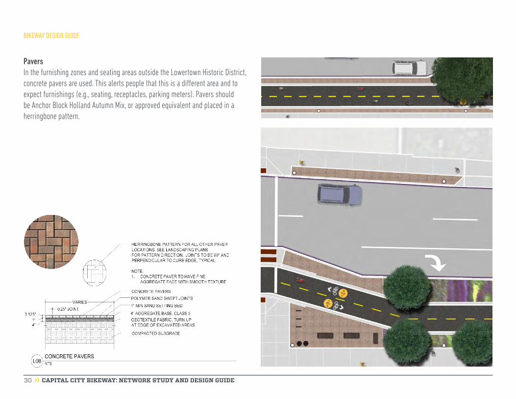
PaversIn the furnishing zones and seating areas outside the Lowertown Historic District, concrete pavers are used. This alerts people that this is a different area and to expect furnishings (e.g., seating, receptacles, parking meters). Pavers should be Anchor Block Holland Autumn Mix, or approved equivalent and placed in a herringbone pattern.
BIKEWAY DESIGN GUIDE

CAPITAL CITY BIKEWAY: NETWORK STUDY AND DESIGN GUIDE 31
NMajor Bikeway4th Street Market District Existing BikewayPlanned Bikeway
BIKEWAY TYPE
Minor Bikeway Major
Minor
WAYFINDING
4th Street Market District
Minnesota Street
Wabasha Street
Broadway
Street
St. Peter Street
Kellogg Boulevard
Cedar Street
Jackson Street
Robert Street
Wash
ingt
on S
treet
US Highway 52
9th Street
4th Street
Prince Street
Kellogg Boulevard
Samuel H. Morgan Regional Trail
10th Street
10th Street
John
Irelan
d Bou
levard
Wacouta Street
Trout Brook Regional Trail
Charles Avenue
Bruce Vento Regional TrailPa
rk S
treee
t
University Avenue
Figure 11: Capital City Bikeway Wayfinding Map
BIKEWAY DESIGN GUIDE
WayfindingWayfinding assures people they are on the correct route and helps users reach their desired destinations. The Capital City Bikeway wayfinding system complements existing signage systems in the city, though is primarily focused on helping bicyclists navigate the Capital City Bikeway routes and connect to other key local, regional, and state bicycle routes. The signage within the wayfinding system meets the Manual of Uniform Traffic Control Devices (MUTCD) guidelines and is guided by the identity system described earlier.
Wayfinding LocationsCapital City Bikeway signage should be placed at key points along each corridor. Directional signage should be placed at major decision points such as bikeway intersections, or directing bicyclists to connecting routes (e.g., Samuel Morgan Regional Trail, Gateway State Trail). Signage indicating bikeway and sidewalk locations should be placed at every intersection to clearly direct people where to bike and where to walk. Pavement markings with the Capital City Bikeway logo should also be placed at intersections further distinguishing the bikeway from the sidewalk.
Figure 11 shows major and minor wayfinding locations and the following pages describe the approach to major and minor wayfinding types and locations. Major wayfinding sites are located where two major Capital City Bikeway routes intersect. Minor wayfinding sites are located at intersections of major and minor bikeways. 4th Street should also have wayfinding at intersections with major and minor bikeways, but the design of these signs should be completed with the 4th Street Market Street design process.

CAPITAL CITY BIKEWAY: NETWORK STUDY AND DESIGN GUIDE 32
Major wayfinding examples. For illustrative purposes only.
Major Wayfinding LocationsFour major wayfinding sites are located where two major Capital City Bikeway routes intersect (Figure 11). At these locations, urban kiosks should be placed and include information about the routes, regional connections, and key destinations in downtown Saint Paul. The graphics below depict different options of signage elements for major wayfinding locations.
BIKEWAY DESIGN GUIDE

directional signage operational signage operational and reinforcement signage
CAPITAL CITY BIKEWAY: NETWORK STUDY AND DESIGN GUIDE 33
Minor Wayfinding LocationsMinor wayfinding are also located on major bikeways at locations where a major bikeway intersects with a minor, existing, or planned bikeway. At these locations, wayfinding consists of directional, operational, and reinforcement signage.
Directional signage provides direction to key connections such as the Gateway State Trail and the Samuel Morgan Regional Trail. Operational signage provides confirmation that the user is on the Capital City Bikeway routes, provides information for connecting segments of the Capital City Bikeway and clearly communicates where bicyclists and pedestrians should be. Operational signage also reminds people to look for cyclists at key conflict points (e.g., driveways, areas where bicyclists and pedestrians mix).
BIKEWAY DESIGN GUIDE
CAPITAL CITY BIKEWAY: NETWORK STUDY AND DESIGN GUIDE 34
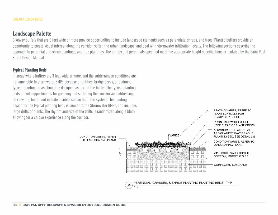
Landscape PaletteBikeway buffers that are 3 feet wide or more provide opportunities to include landscape elements such as perennials, shrubs, and trees. Planted buffers provide an opportunity to create visual interest along the corridor, soften the urban landscape, and deal with stormwater infiltration locally. The following sections describe the approach to perennial and shrub plantings, and tree plantings. The shrubs and perennials specified meet the appropriate height specifications articulated by the Saint Paul Street Design Manual.
Typical Planting BedsIn areas where buffers are 3 feet wide or more, and the subterranean conditions are not amenable to stormwater BMPs because of utilities, bridge decks, or bedrock, typical planting areas should be designed as part of the buffer. The typical planting beds provide opportunities for greening and softening the corridor and addressing stormwater, but do not include a subterranean drain tile system. The planting design for the typical planting beds is similar to the Stormwater BMPs, and includes large drifts of plants. The rhythm and size of the drifts is randomized along a block allowing for a unique experience along the corridor.
BIKEWAY DESIGN GUIDE

CAPITAL CITY BIKEWAY: NETWORK STUDY AND DESIGN GUIDE 35
Typical Planting Bed Species
PLANT NAME: Sporobolus heterolepis, Prairie Dropseed
CHARACTERISTICS: Native perennial grass that grows in average, dry to medium, well-drained soils in full sun. Reaches 2-3' tall.
SEASONAL INTEREST: Fine-textured, hair-like, medium green leaves form an arching foliage mound.
PLANT NAME: Anemone sylvestris, Anemone
CHARACTERISTICS: Grows 12-20” tall in loose soils.
SEASONAL INTEREST: Slightly fragrant flowers are borne above soft-textured blue-green foliage in late spring.
PLANT NAME: Nepeta x faassenii, ‘Walker’s Low, Walker’s Low Catmint
CHARACTERISTICS: Grows 24”-30” tall in average, dry to medium, well-drained soil in full sun to part shade.
SEASONAL INTEREST: Showy periwinkle blue flower spikes adorn fragrant mounds of gray-green foliage.
PLANT NAME: Salvia nemrosa ‘mainacht’, Salvia
CHARACTERISTICS: Clump forming. Grows in average, dry to medium, well-drained soil in full sun, 18” tall.
SEASONAL INTEREST: Deep violet-blue color provides excellent contrast in the perennial border.
PLANT NAME: Astilbe x arendsii ‘Beauty of Ernst’, Astilbe
CHARACTERISTICS: Upright habit, rapid growth rate to 18” tall.
SEASONAL INTEREST: Light pink flowers on upright to slightly arching stems rising above the foliage. Leaves emerge green, mature to burgundy-purple and turn gold, orange and russet in fall.
PLANT NAME: Rhus aromatica ‘Gro-Low’, Gro-Low Fragrant Sumac
CHARACTERISTICS: Dense, low-growing, rambling shrub which spreads by root suckers and typically grows 12-24” tall.
SEASONAL INTEREST: Fragrant leaves turn attractive shades of orange and red in autumn.
PLANT NAME: Spirea x bumalda ‘Magic Carpet’, Spirea ‘Magic Carpet’
CHARACTERISTICS: Neat, compact mounded shrub, 18-24” tall.
SEASONAL INTEREST: Clusters of small pink flowers contrast with bright gold mature foliage that turns rich russet-red in fall.
PLANT NAME: Astilbe japonica ‘Deutchland’, Astilbe
CHARACTERISTICS: Clump-forming perennials which feature graceful, fern-like mounds 20-24” tall.
SEASONAL INTEREST: Lustrous green leaves and upright panicles of pure white flowers in late spring.
BIKEWAY DESIGN GUIDE

CAPITAL CITY BIKEWAY: NETWORK STUDY AND DESIGN GUIDE 36
Stormwater Best Management Practices (BMPs)In areas where buffers are 5 feet or more and subterranean conditions allow for it, the Capital City Bikeway should incorporate stormwater BMPs (called Bio-Infiltration Basin Systems in the Saint Paul Street Design Manual). A Bio-Infiltration Basin System or stormwater BMP is a large scale, depressed landscaped feature intended to hold a specified amount of stormwater runoff from moderate to relatively high amounts of impervious surface. Stormwater is retained while it infiltrates into the soil below and then into the underground water conveyance system. Capital City Bikeway stormwater BMPs are designed to allow water from the motor vehicle travel lanes, the bikeway, and sidewalks to enter the basins. Curb cuts on the vehicle travel lanes allow for water to enter the basins. The sidewalks and bikeway are sloped so water flows into the basins.
Plant species are described on the following page. The planting design along the corridor includes large drifts of plants. The rhythm and size of the drifts is randomized allowing for a unique experience along the corridor.
STORMWATER BMP
BIKEWAY DESIGN GUIDE

CAPITAL CITY BIKEWAY: NETWORK STUDY AND DESIGN GUIDE 37
Stormwater BMP Species
PLANT NAME: Cornus sericea ‘Kelseyi’, Kelsey Dwarf Dogwood CHARACTERISTICS: Low growing deciduous groundcover 30” Tall. Adapted to moist, well-drained soil.
SEASONAL INTEREST: Bright green leaves and masses of white flowers appearing in late spring, red branches provide winter interest.
PLANT NAME: Echinacea purpurea, Purple Coneflower
CHARACTERISTICS: Clump forming native perennial, 24-36” height.
SEASONAL INTEREST: Showy, daisy-like, purple coneflowers, summer.
PLANT NAME: Panicum virgatum ‘Shenandoah’, Switchgrass
CHARACTERISTICS: Grows to 36” tall in average, medium to wet soils in full sun to part shade.
SEASONAL INTEREST: Foliage emerges bluish-green turning burgundy-red by late June. Reddish-pink cloud like flowers. Good winter interest.
PLANT NAME: Iris versicolor, Blue Flag Iris
CHARACTERISTICS: Sword-shaped, blue-green leaves, 24-30” height.
SEASONAL INTEREST: Bold purple flowers in late spring.
PLANT NAME: Juncus effuses, Soft Rush
CHARACTERISTICS: Tolerates erosion and wet soil, 24-36” height.
SEASONAL INTEREST: Cylindrical upright green stems in spreading basal clumps.
PLANT NAME: Liatris pycnostachya, Prairie Blazing Star
CHARACTERISTICS: Grows to 24-48”’ tall in average, dry to medium, well-drained soils in full sun.
SEASONAL INTEREST: Round, fluffy, deep rose-purple flower heads. Strong vertical accent stems.
PLANT NAME: Liatris spicata ‘Floristian White’, Blazing Star
CHARACTERISTICS: Grows to 36” tall in average, dry to medium, well-drained soils in full sun.
SEASONAL INTEREST: Multiple wands of creamy white flowers. Strong vertical accent stems.
PLANT NAME: Carex vulpinoidea, Fox Sedge
CHARACTERISTICS: Native sedge, grows in damp to very wet soils, 12-36” height.
SEASONAL INTEREST: Attractive seedheads, narrow grass-like leaves.
BIKEWAY DESIGN GUIDE

CAPITAL CITY BIKEWAY: NETWORK STUDY AND DESIGN GUIDE 38
Canopy and Ornamental TreesCanopy and ornamental trees should be included along the Capital City Bikeway where feasible. Trees provide necessary shade and a sense of enclosure. Along the Capital City Bikeway, a variety of tree species are specified so that if one species suffers from a blight or other stressors, others may thrive and some of the tree canopy is retained. Similar to the perennial and shrub design, trees locations are randomized; particular attention was paid to sight lines and appropriate spacing given each block context.
Canopy trees are typically 30 feet on center. The species have a minimum height of 40 feet and provide a significant canopy over the bikeway. Species are described on the following page.
Ornamental or small trees are typically 20-30 feet on center. Two of the species, japanese tree lilac and serviceberry, are fragrant and provide great spring interest. Two of the species, serviceberry and ironwood, provide great fall interest with their leaves turning vibrant reds, oranges, and yellows.
BIKEWAY DESIGN GUIDE

CAPITAL CITY BIKEWAY: NETWORK STUDY AND DESIGN GUIDE 39
Tree Species
PLANT NAME: Amelanchier x grandiflora ‘Autumn Brillance’, Serviceberry
CHARACTERISTICS: Native tree, tolerates clay soil, 20-25’ mature height.
SEASONAL INTEREST: Showy, slightly fragrant, white flowers in spring.
PLANT NAME: Quercus bicolor, Swamp White Oak
CHARACTERISTICS: Medium sized, deciduous tree with a broad, rounded crown reaching 50-60’ tall.
SEASONAL INTEREST: Fall color is yellow, but sometimes reddish purple.
PLANT NAME: Gleditisia triacanthos f. inermis ‘Skyline’, Honeylocust ‘Skyline’
CHARACTERISTICS: Pyramidal growth with a central leader. It is a thornless and nearly seedless variety that typically grows to 40-50’ tall.
SEASONAL INTEREST: Leaves turn an attractive yellow in fall.
PLANT NAME: Syringa reticulata ‘Ivory Silk’, Japanese Tree Lilac
CHARACTERISTICS: Native tree, tolerates clay soil, 20 to 25’ mature height.
SEASONAL INTEREST: Fragrant white flower plumes late spring to early summer.
PLANT NAME: Gymnocladus dioicus ‘Stately Manor’, Kentucky Coffee Tree ‘Stately Manor’
CHARACTERISTICS: Large deciduous tree reaching 40-50’ tall.
SEASONAL INTEREST: Yellow fall color.
PLANT NAME: Ulmus ‘Patriot’, Patriot Elm
CHARACTERISTICS: Vase or fountain shaped arching branch structure. Tree reaches 40-50’ tall. Resistant to Dutch elm disease. Tolerant of urban conditions.
SEASONAL INTEREST: Glossy green foliage, yellow fall color.
PLANT NAME: Ostrya virginiana, Ironwood
CHARACTERISTICS: Deciduous native 30-50’ tall.
SEASONAL INTEREST: Attractive sinuous bark. Yellow fall color.
BIKEWAY DESIGN GUIDE

CAPITAL CITY BIKEWAY: NETWORK STUDY AND DESIGN GUIDE 40
Public ArtAs a destination for people walking and bicycling, the Capital City Bikeway presents an opportunity for a linear collection of monumental art works that currently has ten pieces and will only grow with each completed segment. There are a number of site-based opportunities for public art which should be part of future Capital City Bikeway planning and implementation efforts. In general, these opportunities are located at significant intersections, “gateways” to downtown landmarks or significant destinations, or places where the Capital City Bikeway connects to other trails. The experience along the bikeway will benefit from a variety of approaches to the creation of artworks. Some sections of the bikeway may benefit from a more subtle approach where public art is integrated with street infrastructure, which will help to knit the bikeway together. Public art is not limited to stationary installations or physical objects; it can also be in the form of sound, light, and performance based applications.
Overview of ConsiderationsHeritage PreservationThe Capital City Bikeway borders the Lowertown Historic District on Jackson Street and touches other historic resources throughout downtown. Many designated historic properties are adjacent to the Capital City Bikeway, and it is important that the design
and implementation of public art consider the historic context of downtown Saint Paul. Additional information about historic resources is located in Appendix D.
Budget and MaintenanceSite-based art demands durable, simple-to-maintain artworks that are subject to the parameters of the infrastructure project. Integrated art elements can extend the reach of a limited budget by becoming part of the fabric of a building, lighting element, street furniture, infrastructure, paving, or other aspect of a construction project. The Public Art Ordinance Program Guidelines and Technical Manual address the special characteristics for site-based and integrated art and both documents serve as guides for the development of public art along the Capital City Bikeway network.
Existing Public ArtThere are many public art installations throughout Saint Paul. A number of them are located on or in close proximity to Capital City Bikeway routes.
Integrated artworks that become part of the fabric of the bikeway or that serve a functional purpose will be the most appropriate approaches to take in the design of artwork for the bikeway. Recent City Art projects, such as Everyday Poems for City Sidewalk, have emphasized integrating art into street infrastructure. Limited right-of-way widths and funding for artwork can limit opportunities for large-scale or free-standing artworks.
BIKEWAY DESIGN GUIDE
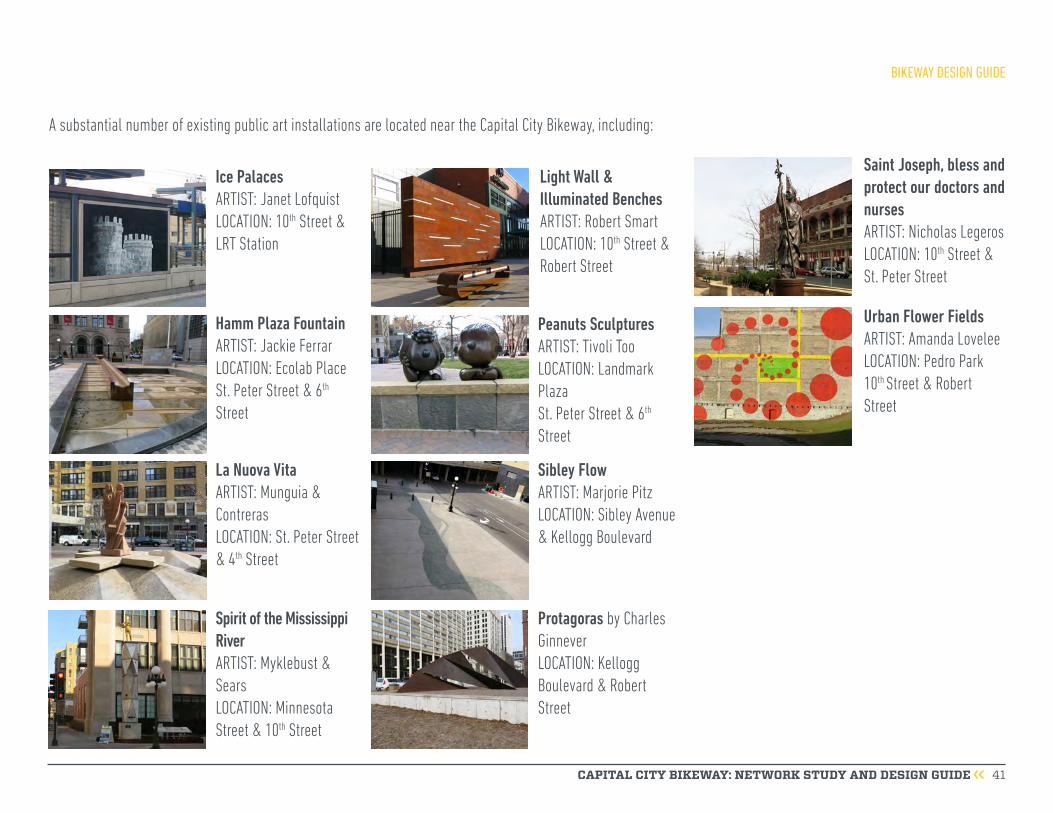
CAPITAL CITY BIKEWAY: NETWORK STUDY AND DESIGN GUIDE 41
A substantial number of existing public art installations are located near the Capital City Bikeway, including:
Ice Palaces ARTIST: Janet LofquistLOCATION: 10th Street & LRT Station
Hamm Plaza Fountain ARTIST: Jackie FerrarLOCATION: Ecolab Place St. Peter Street & 6th Street
La Nuova VitaARTIST: Munguia & ContrerasLOCATION: St. Peter Street & 4th Street
Spirit of the Mississippi River ARTIST: Myklebust & SearsLOCATION: Minnesota Street & 10th Street
Light Wall & Illuminated Benches ARTIST: Robert SmartLOCATION: 10th Street & Robert Street
Peanuts Sculptures ARTIST: Tivoli TooLOCATION: Landmark Plaza St. Peter Street & 6th Street
Sibley Flow ARTIST: Marjorie PitzLOCATION: Sibley Avenue & Kellogg Boulevard
Protagoras by Charles GinneverLOCATION: Kellogg Boulevard & Robert Street
Saint Joseph, bless and protect our doctors and nursesARTIST: Nicholas LegerosLOCATION: 10th Street & St. Peter Street
Urban Flower FieldsARTIST: Amanda LoveleeLOCATION: Pedro Park 10th Street & Robert Street
BIKEWAY DESIGN GUIDE
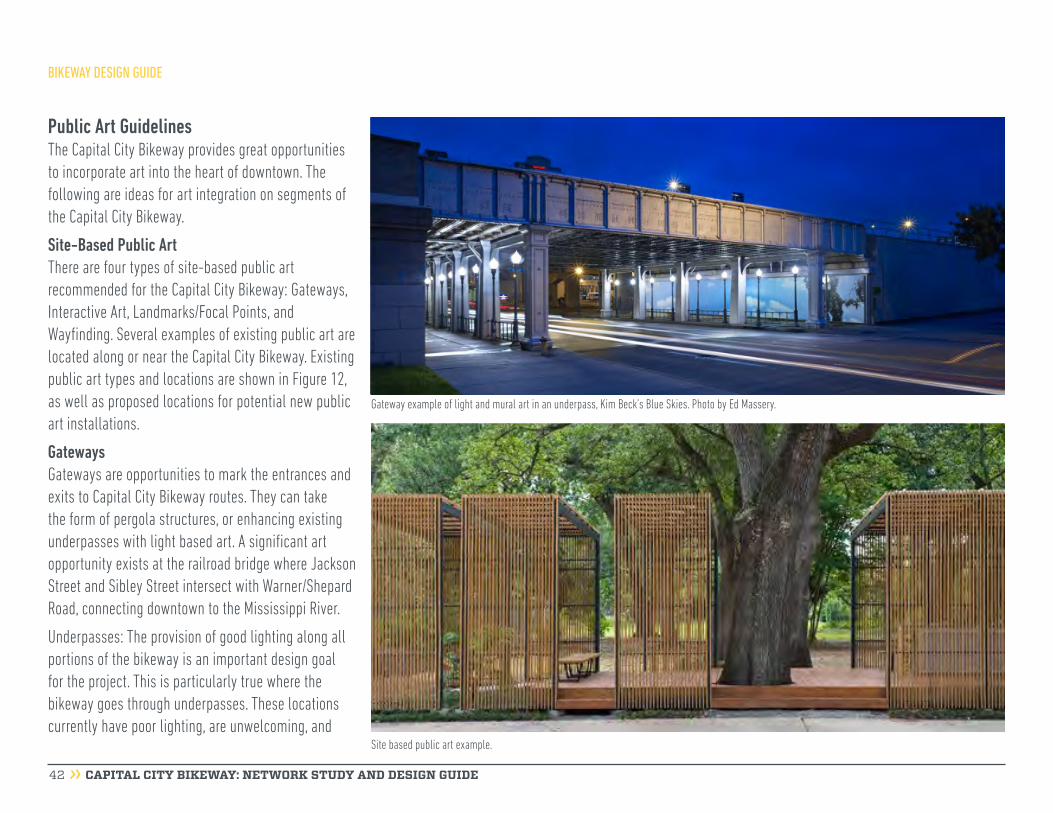
CAPITAL CITY BIKEWAY: NETWORK STUDY AND DESIGN GUIDE 42
Gateway example of light and mural art in an underpass, Kim Beck’s Blue Skies. Photo by Ed Massery.
Public Art GuidelinesThe Capital City Bikeway provides great opportunities to incorporate art into the heart of downtown. The following are ideas for art integration on segments of the Capital City Bikeway.
Site-Based Public ArtThere are four types of site-based public art recommended for the Capital City Bikeway: Gateways, Interactive Art, Landmarks/Focal Points, and Wayfinding. Several examples of existing public art are located along or near the Capital City Bikeway. Existing public art types and locations are shown in Figure 12, as well as proposed locations for potential new public art installations.
GatewaysGateways are opportunities to mark the entrances and exits to Capital City Bikeway routes. They can take the form of pergola structures, or enhancing existing underpasses with light based art. A significant art opportunity exists at the railroad bridge where Jackson Street and Sibley Street intersect with Warner/Shepard Road, connecting downtown to the Mississippi River.
Underpasses: The provision of good lighting along all portions of the bikeway is an important design goal for the project. This is particularly true where the bikeway goes through underpasses. These locations currently have poor lighting, are unwelcoming, and
Site based public art example.
BIKEWAY DESIGN GUIDE
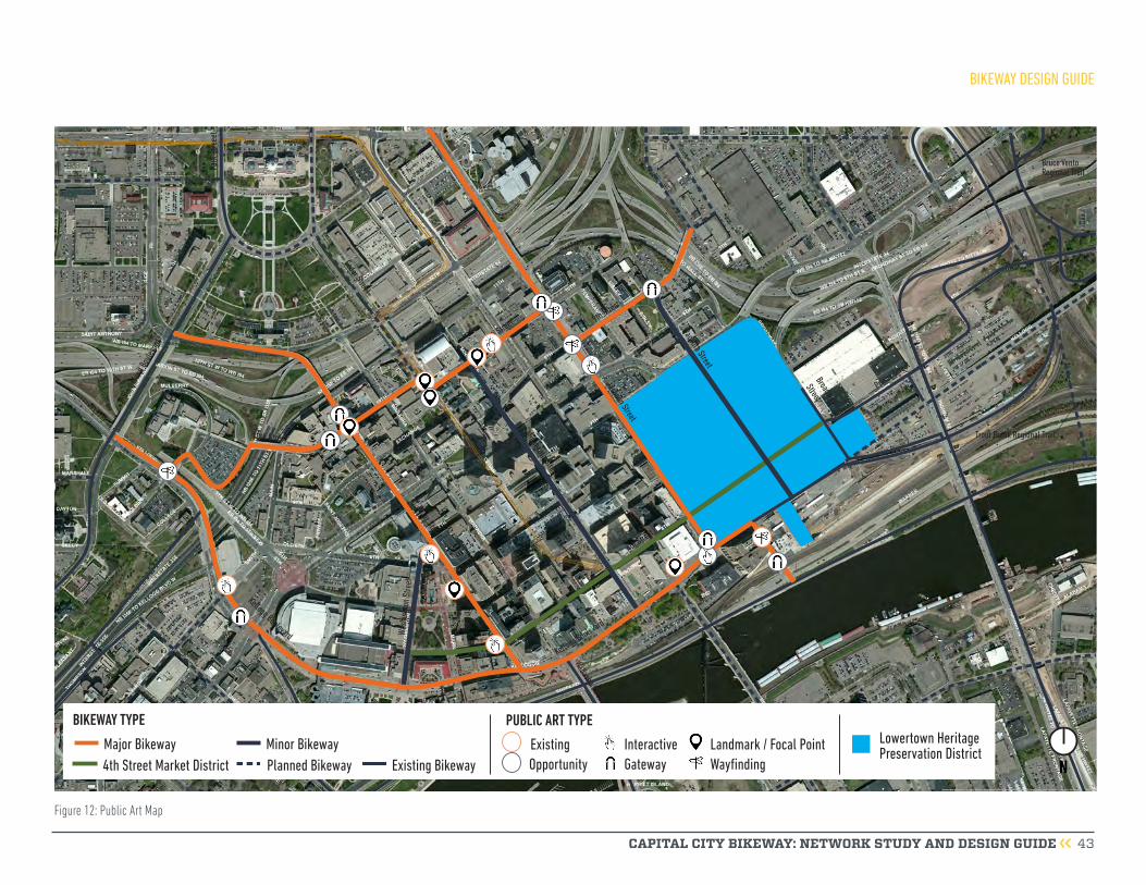
CAPITAL CITY BIKEWAY: NETWORK STUDY AND DESIGN GUIDE 43
Minnesota Street
Wabasha Street
Broadway
Street
St. Peter Street
Kellogg Boulevard
Cedar Street
Jackson Street
Robert StreetWa
shin
gton
Stre
et
US Highway 52
9th Street
4th Street
Prince Street
Kellogg Boulevard
Samuel H. Morgan Regional Trail
10th Street
10th Street
John
Irelan
d Bou
levard
Wacouta StreetTrout Brook Regional Trail
Charles Avenue
Bruce Vento Regional TrailPa
rk S
treee
t
University Avenue
NMajor Bikeway4th Street Market District Existing BikewayPlanned Bikeway
BIKEWAY TYPE
Minor Bikeway
PUBLIC ART TYPE
ExistingGatewayInteractive
WayfindingLandmark / Focal Point
Opportunity
Lowertown Heritage Preservation District
Figure 12: Public Art Map
BIKEWAY DESIGN GUIDE

CAPITAL CITY BIKEWAY: NETWORK STUDY AND DESIGN GUIDE 44
or bronze plate, fabricated steel or bronze, and cast elements in the form of bronze or glass insets. It can include vine plantings and should incorporate lighting for nighttime interest.
Interactive Interactive art provides experiential opportunities to engage with artistic installations. The Capital City Bikeway should be experienced as both a path and a place; that is, a destination people go to for a distinct experience whether traveling through or staying for a longer duration. Interactive art is one way to provide such an experience. Interactive art can be as simple as a sculpture that encourages people to touch or
feel unsafe. Light-based artworks can be integrated within infrastructure elements or can be free-standing; they can mitigate undesirable conditions in these locations and can create memorable placemaking and wayfinding elements. Light-based artworks can effectively increase the sense of safety on a street, and are especially effective during wintertime, when nighttime comes earlier. Light-based artworks are recommended for the underpass at Sibley Street between Kellogg Boulevard and Warner Road, and on 10th Street under St. Joseph’s Hospital. A permanent interactive architectural light installation at Sibley Street and Warner Road will feature motion detectors that will activate changes in light color as people walk or bike through the underpass. This dynamic lighting installation will evoke a sense of movement while guiding people to the Mississippi River, transforming a dark concrete underpass to an attractive gateway between the river and downtown.Pergolas: The pergola structures, which are intended to be gateways into downtown along the various segments of the Capital City Bikeway, are potential art opportunities. The “green screen” trellis material could be artist-designed, or portions of the structures could include art elements. Suitable materials and fabrication techniques might include woven stainless steel or bronze wire mesh, water-jet cut stainless steel
feel it (i.e., Cloud Gate in Millennium Park, Chicago, IL), or reacts with passers-by (i.e., Science Museum of Minnesota Musical Stairs). There are two key spots for interactive art opportunities along Jackson Street: the northeast corner of the intersection of Jackson and 7th Street, and the northwest corner of the intersection of Jackson and Kellogg where a right turn free flow lane is being removed. Additionally, interactive art can be created by playing with sightlines and alignments; the odd element in an unexpected site, and art elements which become part of the path, district, or neighborhood identity.
Site based public art example: Concept Rendering of Capital City Bikeway Pergola.
Interactive art example. Sidewalk Harp, Jen Lewin Studio, Minneapolis, MN.
BIKEWAY DESIGN GUIDE

CAPITAL CITY BIKEWAY: NETWORK STUDY AND DESIGN GUIDE 45
Focal Point/LandmarkFocal point/landmark artworks can create destinations or meeting places along the path, highlight important historic or natural sites, identify a neighborhood or district, signify entry to a segment, or mark a significant transition from one segment to the next. Focal point artworks can help to establish the bikeway as a special place.
Integrated Public ArtIntegrated artworks that become part of the fabric of the bikeway or that serve a functional purpose will be the most appropriate approaches to take in the design of artwork for the bikeway. Recent City Art projects, such as Everyday Poems for City Sidewalk, have emphasized integrating art into street infrastructure. Limited right- Integrated art example. Marcus Young, Everyday Poems for City Sidewalk,
Saint. Paul, MN.
Focal Point/Landmark example. Myklebust+Sears, Heritage4Charlotte, Charlotte-Douglas International Airport, Charlotte, North Carolina.
Integrated art example. Myklebust+Sears, Fox theatre, Stockton, CA.
Ephemeral art that appears when it rains. Peregrine Church.
art budget if artworks serving the same functional purpose are designed, and the funds allocated for their purchase can be transferred to the art budget.
of-way widths and funding for artwork can limit opportunities for large-scale or free-standing artworks.
The two main areas recommended for integrated artwork along the Capital City Bikeway are on the paved buffer areas and on sidewalks. This may include surfaces/claddings, such as pavements, precast, and poured-in-place elements. These types of integrated artworks may allow an expansion of the public
BIKEWAY DESIGN GUIDE
CAPITAL CITY BIKEWAY: NETWORK STUDY AND DESIGN GUIDE 46
The City of Saint Paul plans roadway reconstruction and funding 5 years in advance of construction. As streets are due for reconstruction, implementation of the major bikeways should be considered in the budget and plan. As roads are repaved and maintained, the minor bikeway routes should be considered for implementation using pavement marking and signing as needed. Combining bikeway construction with roadway reconstruction will provide lower construction costs and reduce road closures within downtown Saint Paul. The following is a suggested implementation plan for the Capital City Bikeway and minor bikeway routes in downtown Saint Paul.
Major Bikeways Jackson StreetJackson Street is the first segment of the Capital City Bikeway to be constructed. The roadway pavement on Jackson Street is in need of repair and is driving the reconstruction of the road, while also creating an opportunity to implement a protected bikeway along Jackson Street. The protected bikeway along Jackson Street will fill a key gap in the bicycle network and ultimately connect the Sam Morgan Regional Trail with the Gateway State Trail.
Jackson Street will be reconstructed between 11th Street and Kellogg Boulevard, as well as a short portion of Kellogg Boulevard between Jackson Street and
Sibley Street. The artistic trail on the east side of Sibley Street from Kellogg Boulevard to Warner Road will provide the connection to the Sam Morgan Regional Trail.
Jackson Street will be reconstructed over two construction seasons in 2016 (Warner Road to 7th Place) and 2017 (7th Place to 11th Street and Kellogg Boulevard between Jackson Street and Sibley Street).
As part of a separate City project, the bikeway will be constructed on Jackson Street from 11th street to University Avenue in 2017. Construction began in spring 2016, starting with underground utility work. The total length of the first segment of the Capital City Bikeway (Jackson Street plus the short segments on Kellogg Boulevard and Sibley Street) will be just over one mile.
BIKEWAY IMPLEMENTATION PLAN

CAPITAL CITY BIKEWAY: NETWORK STUDY AND DESIGN GUIDE 47
BIKEWAY IMPLEMENTATION PLAN

11th Street
NORTH
CAPITAL CITY BIKEWAY: NETWORK STUDY AND DESIGN GUIDE 48
JACKSON STREET
11TH STREET
JACKSON STREET
I-94 RAMP
10TH STREET
connection to Gateway State Trail and University Avenue (2017 construction)
seating area
bicycle parkingtypical planting bed
future gateway pergola structure, footings will be installed during
Jackson Street reconstruction
future connection to 10th Street segment of the Capital City Bikeway
stormwater BMP is a green buffer between sidewalk and travel lanes
curb extensions to shorten pedestrian crossing distances
improved sidewalk
trash and recycling receptacles

CAPITAL CITY BIKEWAY: NETWORK STUDY AND DESIGN GUIDE 49
JACKSON STREET
9TH STREEThigh visibility bicycle crossings at all driveway locations high visibility
bicycle crossings at intersections
sidewalkstormwater BMPs stormwater BMPs
typical planting bed parking
widened sidewalk
parking
future connection to 9th Street segment of the Capital City Bikeway
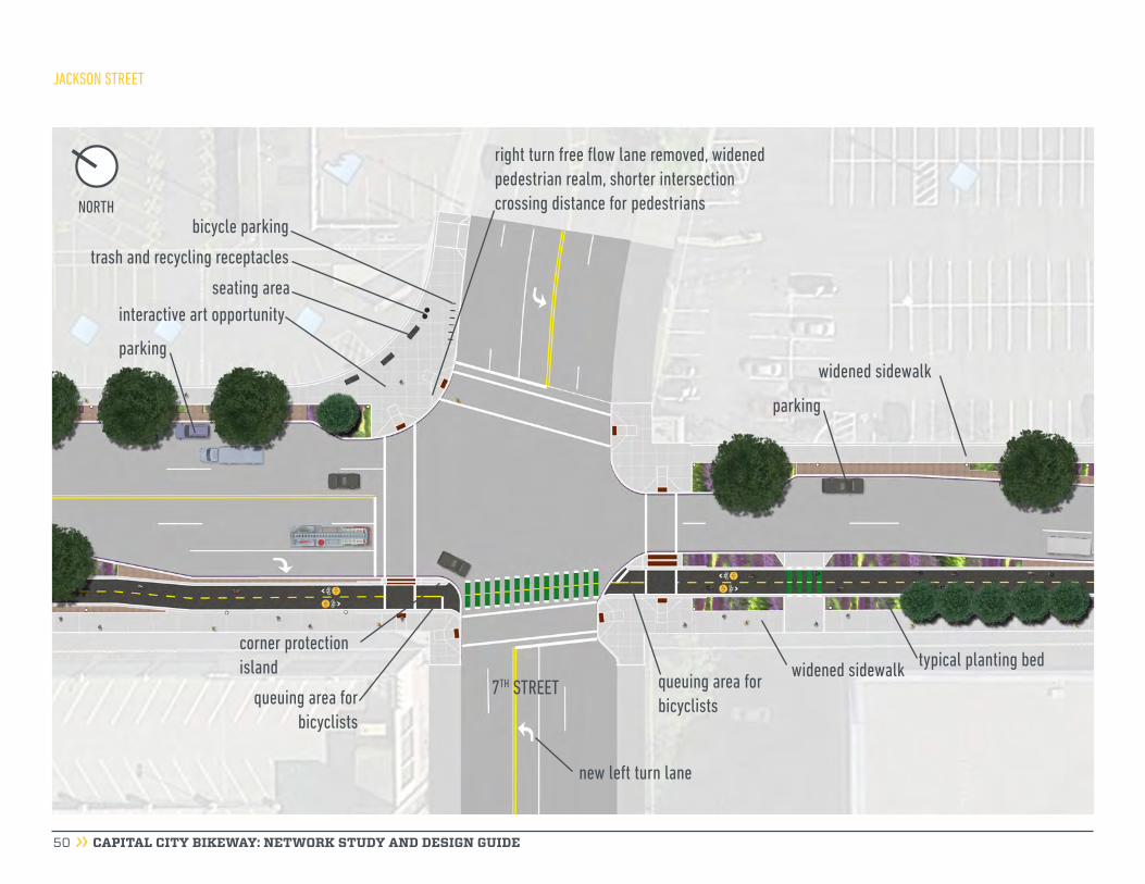
CAPITAL CITY BIKEWAY: NETWORK STUDY AND DESIGN GUIDE 50
JACKSON STREET
7TH STREET
new left turn lane
seating areainteractive art opportunity
parking
corner protection island
queuing area for bicyclists
queuing area for bicyclists
right turn free flow lane removed, widened pedestrian realm, shorter intersection crossing distance for pedestrians
parking
widened sidewalk
bicycle parking
trash and recycling receptacles
widened sidewalk typical planting bed
NORTH
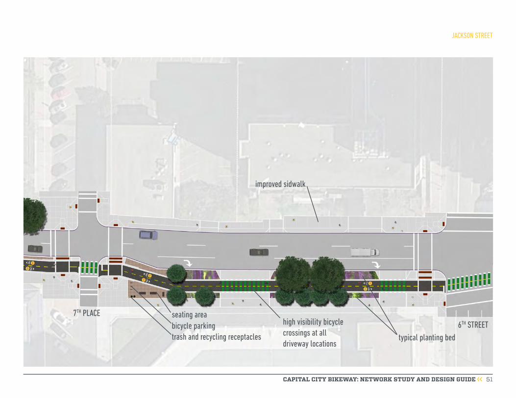
CAPITAL CITY BIKEWAY: NETWORK STUDY AND DESIGN GUIDE 51
JACKSON STREET
7TH PLACE 6TH STREET
seating areabicycle parkingtrash and recycling receptacles typical planting bed
improved sidwalk
high visibility bicycle crossings at all driveway locations
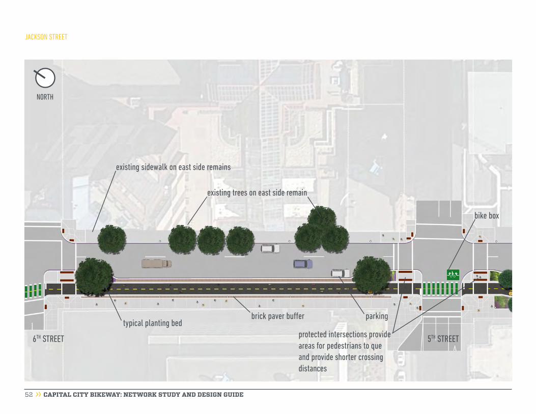
CAPITAL CITY BIKEWAY: NETWORK STUDY AND DESIGN GUIDE 52
JACKSON STREET
6TH STREET 5TH STREET
brick paver buffer parking
bike box
typical planting bed
existing sidewalk on east side remains
existing trees on east side remain
protected intersections provide areas for pedestrians to que and provide shorter crossing distances
NORTH

CAPITAL CITY BIKEWAY: NETWORK STUDY AND DESIGN GUIDE 53
JACKSON STREET
4TH STREETtypical planting bed
parking
existing sidewalk on east side remains existing sidewalk on east side remains
future connection to 4th Street bikeway
existing trees on east side remain
seating areabicycle parking
future gateway pergola structure, footings will be installed during Jackson Street reconstruction
trash and recycling receptacles
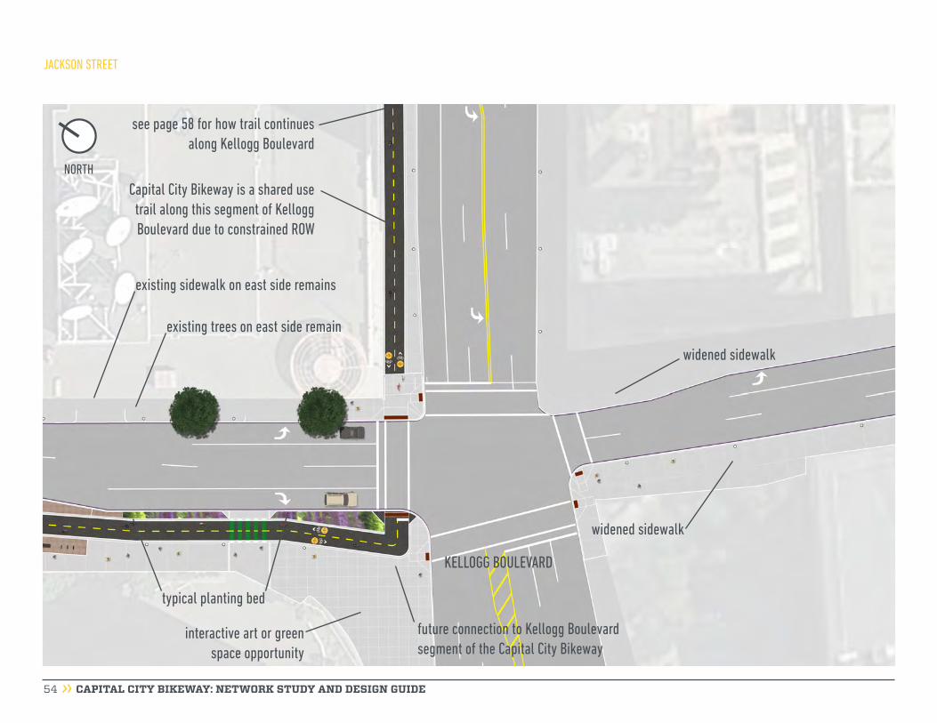
CAPITAL CITY BIKEWAY: NETWORK STUDY AND DESIGN GUIDE 54
JACKSON STREET
existing sidewalk on east side remains
Capital City Bikeway is a shared use trail along this segment of Kellogg Boulevard due to constrained ROW
see page 58 for how trail continues along Kellogg Boulevard
existing trees on east side remain
typical planting bed
KELLOGG BOULEVARD
interactive art or green space opportunity
widened sidewalk
widened sidewalk
future connection to Kellogg Boulevard segment of the Capital City Bikeway
NORTH
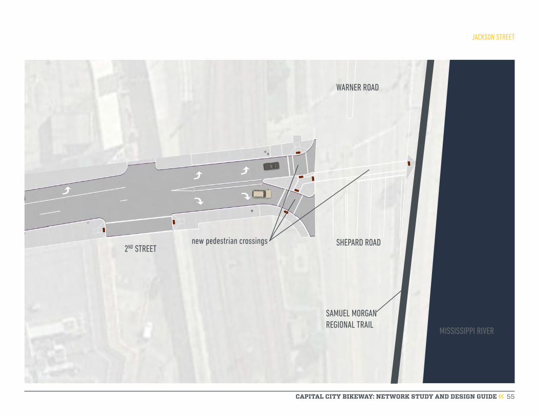
CAPITAL CITY BIKEWAY: NETWORK STUDY AND DESIGN GUIDE 55
JACKSON STREET
2ND STREETSHEPARD ROAD
WARNER ROAD
SAMUEL MORGAN REGIONAL TRAIL
new pedestrian crossings
MISSISSIPPI RIVER

CAPITAL CITY BIKEWAY: NETWORK STUDY AND DESIGN GUIDE 56
KELLOGG BOULEVARD AND SIBLEY STREET
KELLOGG BOULEVARD
see page 56 for how trail continues along Kellogg Boulevard
Capital City Bikeway is a shared use trail along this segment of Kellogg Boulevard due to constrained ROW
pedestrian crossing
bicycle crossing
curb extention
interactive architectural light based art at the underpass to enhance user experience
Capital City Bikeway crosses Sibley Street and bicyclists will use the artistic sidewalk to access Warner Road and the Samuel Morgan Regional Trail
NORTH

CAPITAL CITY BIKEWAY: NETWORK STUDY AND DESIGN GUIDE 57
this page intentionally blank
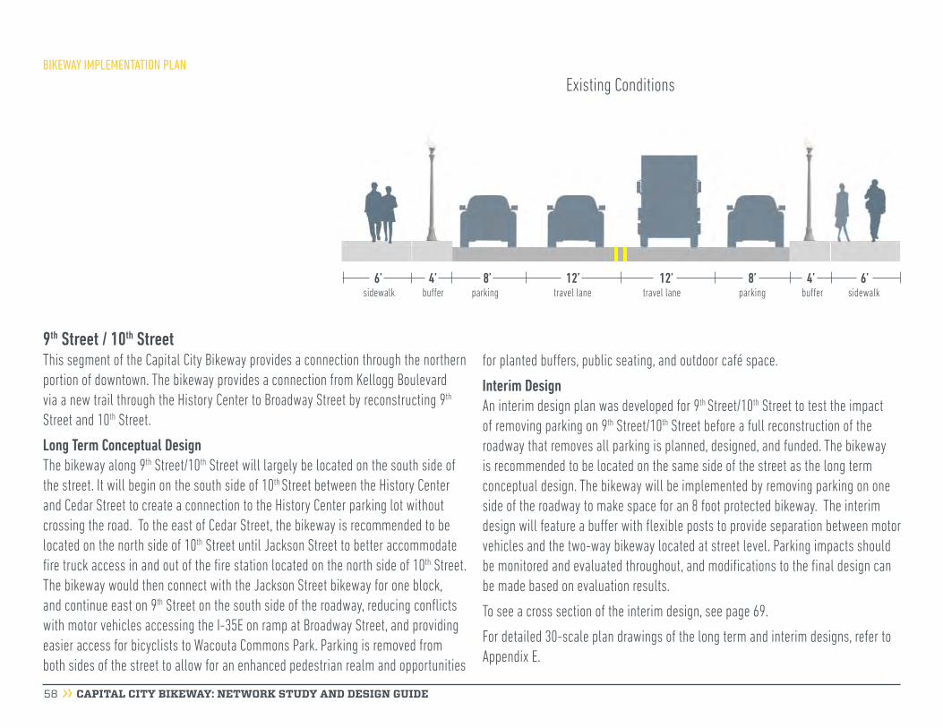
CAPITAL CITY BIKEWAY: NETWORK STUDY AND DESIGN GUIDE 58
9th Street / 10th StreetThis segment of the Capital City Bikeway provides a connection through the northern portion of downtown. The bikeway provides a connection from Kellogg Boulevard via a new trail through the History Center to Broadway Street by reconstructing 9th Street and 10th Street.
Long Term Conceptual DesignThe bikeway along 9th Street/10th Street will largely be located on the south side of the street. It will begin on the south side of 10th Street between the History Center and Cedar Street to create a connection to the History Center parking lot without crossing the road. To the east of Cedar Street, the bikeway is recommended to be located on the north side of 10th Street until Jackson Street to better accommodate fire truck access in and out of the fire station located on the north side of 10th Street. The bikeway would then connect with the Jackson Street bikeway for one block, and continue east on 9th Street on the south side of the roadway, reducing conflicts with motor vehicles accessing the I-35E on ramp at Broadway Street, and providing easier access for bicyclists to Wacouta Commons Park. Parking is removed from both sides of the street to allow for an enhanced pedestrian realm and opportunities
BIKEWAY IMPLEMENTATION PLAN
for planted buffers, public seating, and outdoor café space.
Interim DesignAn interim design plan was developed for 9th Street/10th Street to test the impact of removing parking on 9th Street/10th Street before a full reconstruction of the roadway that removes all parking is planned, designed, and funded. The bikeway is recommended to be located on the same side of the street as the long term conceptual design. The bikeway will be implemented by removing parking on one side of the roadway to make space for an 8 foot protected bikeway. The interim design will feature a buffer with flexible posts to provide separation between motor vehicles and the two-way bikeway located at street level. Parking impacts should be monitored and evaluated throughout, and modifications to the final design can be made based on evaluation results.
To see a cross section of the interim design, see page 69.
For detailed 30-scale plan drawings of the long term and interim designs, refer to Appendix E.
6’ 6’4’sidewalk sidewalkbuffer bufferparking parkingtravel lane travel lane
4’8’ 8’12’ 12’
Existing Conditions

CAPITAL CITY BIKEWAY: NETWORK STUDY AND DESIGN GUIDE 59
9TH/10TH STREET
7’ 7’5’sidewalk sidewalkbuffer bufferbikeway buffer travel lane travel lane
5’10’ 2’ 12’ 12’
Proposed Conditions
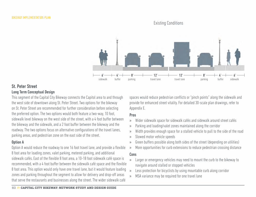
CAPITAL CITY BIKEWAY: NETWORK STUDY AND DESIGN GUIDE 60
St. Peter StreetLong Term Conceptual DesignThis segment of the Capital City Bikeway connects the Capitol area to and through the west side of downtown along St. Peter Street. Two options for the bikeway on St. Peter Street are recommended for further consideration before selecting the preferred option. The two options would both feature a two-way, 10 foot, sidewalk level bikeway on the west side of the street, with a 4 foot buffer between the bikeway and the sidewalk, and a 2 foot buffer between the bikeway and the roadway. The two options focus on alternative configurations of the travel lanes, parking areas, and pedestrian zone on the east side of the street.
Option AOption A would reduce the roadway to one 16 foot travel lane, and provide a flexible 8 foot area for loading zones, valet parking, metered parking, and additional sidewalk cafés. East of the flexible 8 foot area, a 10-18 foot sidewalk café space is recommended, with a 4 foot buffer between the sidewalk café space and the flexible 8 foot area. This option would only have one travel lane, but it would feature loading zones and parking throughout the segment to allow for delivery and drop-off areas that serve the restaurants and businesses along the street. The wider sidewalk café
BIKEWAY IMPLEMENTATION PLAN
spaces would reduce pedestrian conflicts or “pinch points” along the sidewalk and provide for enhanced street vitality. For detailed 30-scale plan drawings, refer to Appendix E.
Pros » Wider sidewalk space for sidewalk cafés and sidewalk around street cafés » Parking and loading/valet zones maintained along the corridor » Width provides enough space for a stalled vehicle to pull to the side of the road » Slowed motor vehicle speeds » Green buffers possible along both sides of the street (depending on utilities) » More opportunities for curb extensions to reduce pedestrian crossing distance
Cons » Larger or emergency vehicles may need to mount the curb to the bikeway to
navigate around stalled or stopped vehicles » Less protection for bicyclists by using mountable curb along corridor » MSA variance may be required for one travel lane
6’ 6’4’sidewalk sidewalkbuffer bufferparking parkingtravel lane travel lane
4’8’ 8’12’ 12’
Existing Conditions
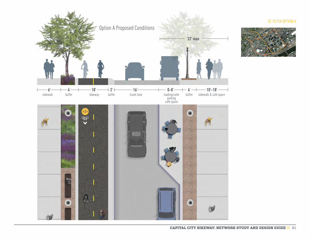
CAPITAL CITY BIKEWAY: NETWORK STUDY AND DESIGN GUIDE 61
ST. PETER OPTION A
6’ 10’-18’
22’ max
4’ 4’10’ 2’ 16’ 0-8’sidewalk sidewalk & café space buffer bufferbikeway buffer travel lane loading/valet
parking café space
Option A Proposed Conditions
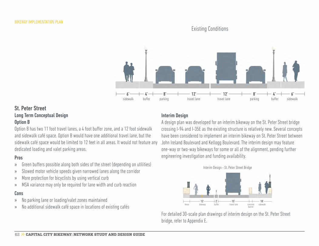
CAPITAL CITY BIKEWAY: NETWORK STUDY AND DESIGN GUIDE 62
St. Peter StreetLong Term Conceptual DesignOption BOption B has two 11 foot travel lanes, a 4 foot buffer zone, and a 12 foot sidewalk and sidewalk café space. Option B would have one additional travel lane, but the sidewalk café space would be limited to 12 feet in all areas. It would not feature any dedicated loading and valet parking areas.
Pros » Green buffers possible along both sides of the street (depending on utilities) » Slowed motor vehicle speeds given narrowed lanes along the corridor » More protection for bicyclists by using vertical curb » MSA variance may only be required for lane width and curb reaction
Cons » No parking lane or loading/valet zones maintained » No additional sidewalk café space in locations of existing cafés
BIKEWAY IMPLEMENTATION PLAN
Interim DesignA design plan was developed for an interim bikeway on the St. Peter Street bridge crossing I-94 and I-35E as the existing structure is relatively new. Several concepts have been considered to implement an interim bikeway on St. Peter Street between John Ireland Boulevard and Kellogg Boulevard. The interim design may feature one-way or two-way bikeways for some or all of the alignment, pending further engineering investigation and funding availability.
6’ 6’4’sidewalk sidewalkbuffer bufferparking parkingtravel lane travel lane
4’8’ 8’12’ 12’
Existing Conditions
Interim Design - St. Peter Street Bridge
12’ 2’ 15’ 10’fence bikeway buffer travel lane sidewalkconcrete
barrier
For detailed 30-scale plan drawings of interim design on the St. Peter Street bridge, refer to Appendix E.
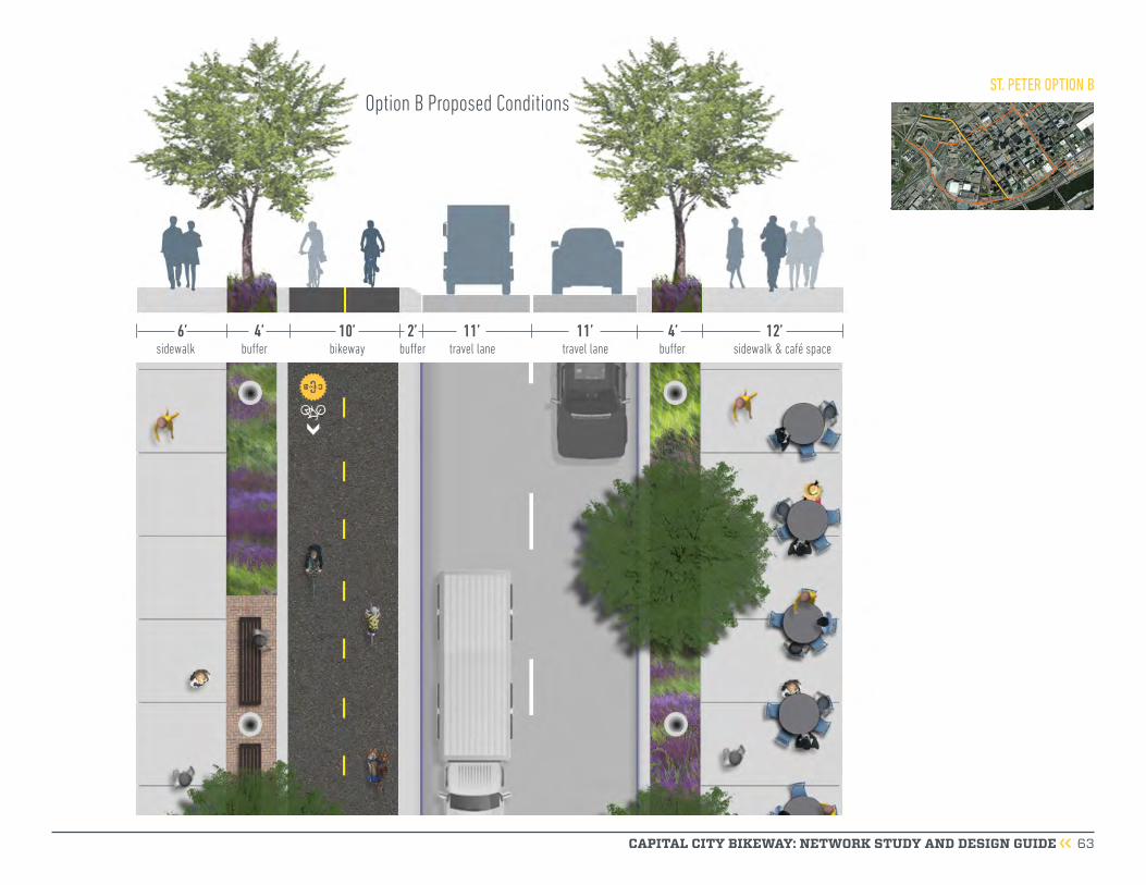
CAPITAL CITY BIKEWAY: NETWORK STUDY AND DESIGN GUIDE 63
ST. PETER OPTION B
6’ 12’4’ 4’10’ 2’ 11’ 11’sidewalk sidewalk & café space buffer bufferbikeway buffer travel lane travel lane
Option B Proposed Conditions

BIKEWAY IMPLEMENTATION PLAN
CAPITAL CITY BIKEWAY: NETWORK STUDY AND DESIGN GUIDE 64
Kellogg BoulevardLong Term Conceptual DesignThis Capital City Bikeway segment provides a connection from the far northwestern edge of downtown to and through the southern portion of downtown. The bikeway on Kellogg Boulevard is recommended to be on the east side of the street from John Ireland Boulevard to 7th Street and on the north side of the street from 7th Street to Sibley Street.
The design of the bikeway respects and accommodates the loading and drop off areas along Kellogg Boulevard, which are located near the Xcel Energy Center, the River Centre, and the InterContinental Hotel. Two westbound travel lanes are provided throughout the corridor, with left turn lanes at Robert Street and Wabasha Street. Removing parking and the dedicated right turn lanes on the north side of Kellogg Boulevard is necessary to provide the space for the two-way, sidewalk level protected bikeway. The right-of-way along Kellogg Boulevard varies significantly. Detailed 30-scale design drawings are shown in Appendix E.
varies varies0’-4’ 0’-8’ 10’-12’10’-14’ 10’-12’ 10’-14’10’-13’0’-20’10’-13’ 0’-8’ 0’-4’sidewalk sidewalkbufferbuffer parkingparking travel lane travel lanetravel lane travel lane travel lane travel lanemedian
Existing Conditions
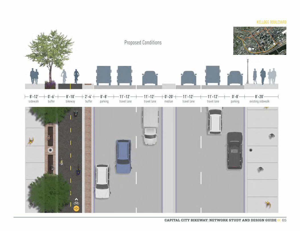
CAPITAL CITY BIKEWAY: NETWORK STUDY AND DESIGN GUIDE 65
8’-12’ 8’-20’0’-6’ 8’-10’ 0’-8’2’-4’ 11’-12’11’-12’11’-12’11’-12’ 0’-8’0’-20’sidewalk existing sidewalkbuffer parkingbikeway buffer travel laneparking travel lane travel lane travel lanemedian
Proposed Conditions
KELLOGG BOULEVARD

CAPITAL CITY BIKEWAY: NETWORK STUDY AND DESIGN GUIDE 66
generators, the relative number of anticipated users, the trip and facility length and connectivity to other bikeways or jurisdictions, and the appropriate modal balance relative to the competing needs of the multi-modal transportation system”. The anticipated function of minor bikeways is to provide neighborhood level connectivity to the major bikeway network.
A common theme raised by the community was a desire for a bicycle network that connects to and within downtown. The minor bikeways help to provide a more complete network of bike facilities in downtown Saint Paul. See Figure 13 for the location of the minor bikeways.
The following are minor bikeways of downtown:
» Minnesota Street - 10th Street to Kellogg BoulevardThis planned minor bikeway is recommended to be a one-way, buffered bike lane on the west side of the street. Detailed 30-scale design drawings are available in Appendix E.
» Washington Street - St. Peter Street to Kellogg Boulevard
» Wacouta Street - 9th Street to Kellogg Boulevard
4th Street Market DistrictConceptual DesignIn 2015, the Saint Paul Riverfront Corporation prepared the 4th Street Market District Summary Report, which was funded and endorsed by 4th Street building and business owners. The report describes a vision for 4th Street to be transformed into a thriving market district, and an additional east-west bikeway and pedestrian thoroughfare in downtown. The 4th Street Market District report describes a connected corridor along 4th Street from the RiverCentre on Washington Street to CHS Field on Broadway Street. Recommendations from the report include enhanced bikeway and pedestrian connections, shared spaces, amenities, wayfinding, increased and enhanced street level retail, and the addition of public art to create interesting spaces and community identity. See Appendix F for the 4th Street Market District Summary Report.
Minor BikewaysThe Saint Paul Bicycle Plan establishes a new bicycle network functional classification system, which classifies each corridor of the proposed bicycle network as a major or a minor bikeway. According to the Saint Paul Bicycle Plan, the distinguishing features between the two bicycle network functional classifications include “the level of investment anticipated on each corridor, the connections to major attractions or trip
Cover of the 4th Street Market District Summary Report
BIKEWAY IMPLEMENTATION PLAN

CAPITAL CITY BIKEWAY: NETWORK STUDY AND DESIGN GUIDE 67
NMajor Bikeway4th Street Market District Existing BikewayPlanned Bikeway
BIKEWAY TYPE
Minor Bikeway
Minnesota Street
Wabasha Street
Broadway
Street
St. Peter Street
Kellogg Boulevard
Cedar Street
Jackson Street
Robert StreetWa
shin
gton
Stre
et
US Highway 52
9th Street
4th Street
Prince Street
Kellogg Boulevard
Samuel H. Morgan Regional Trail
10th Street
10th Street
John
Irelan
d Bou
levard
Wacouta StreetTrout Brook Regional Trail
Charles Avenue
Bruce Vento Regional TrailPa
rk S
treee
t
University Avenue
Figure 13: Capital City Bikeway Network Map
BIKEWAY IMPLEMENTATION PLAN

CAPITAL CITY BIKEWAY: NETWORK STUDY AND DESIGN GUIDE 68
Phasing Plan and Cost EstimatesFunding for implementing the Capital City Bikeway has been secured for Jackson Street and one block of Kellogg Boulevard. Funding for the phased implementation of the entire network will come from a variety of sources that may include the City budget, state and federal grants, and Municipal State Aid. Planning level cost estimates are provided for the Capital City Bikeway network, interim bikeway facilities, and a bikeway on Minnesota Street (Figure 14). The graphics on page 69 show existing conditions, interim treatment, and long term proposed conditions as a phasing example.
BIKEWAY IMPLEMENTATION PLAN
Figure 14: Capital City Bikeway Phasing Plan and Cost Estimates
TimeframeStreetName
StreetSegment
BikewayClassification
Vertical Separation
MethodLong Term or
Interim TreatmentImplementation
Scale Budget Funding Status2016 Jackson Street Shepard/Warner Road to 7th Place Major Bikeway Curb Long Term Full street reconstruction 7,750,000$ In-place
Jackson Street 7th Place to 11th Street Major Bikeway Curb Long Term Full street reconstruction 7,750,000$ In-place
Jackson Street 11th Street to University Avenue Major Bikeway Curb Long TermBridge modification, Full Street Reconstruction north of 12th Street
6,000,000$ In-place
Kellogg Boulevard Jackson Street to Sibley Street Major Bikeway Curb Long Term Protected Bikeway on north side of street 500,000$ In-place9th /10th Street History Center driveway to Broadway Street Major Bikeway Flexible Posts Interim Pavement markings, flex posts, and signage (Only) $ *660,000 Propose for CIB12th / St. Peter St John Ireland Boulevard to Kellogg Blvd Major Bikeway Flexible Posts Interim Pavement markings, flex posts, and signage (Only) $ *440,000 Propose for CIB
Minnesota Street Kellogg Boulevard to 10th Street Minor Bikeway None Interim Pavement markings, flex posts, signage, asphalt overlay, sidewalk repairs
$ *1,200,000 Propose for CIB
4th Street Minnesota Street to Broadway Street Mixed Use TBD Interim Pavement markings, flex posts, and signage (Only) TBD TBD
Kellogg Boulevard John Ireland Boulevard to 7th Street Major Bikeway Curb Long TermPartial to full street reconstruction(no bridge reconstruction)
TBD TBD
History Center Kellogg Boulevard to driveway on 10th Street Major Bikeway Curb Long Term Trail construction TBD TBD
Kellogg Boulevard 7th Street to Jackson Street Major Bikeway Curb Long TermFull street reconstruction(no bridge reconstruction)
TBD TBD
St. Peter Street John Ireland Boulevard to Kellogg Boulevard Major Bikeway Curb Long TermFull street reconstruction(no bridge reconstruction)
TBD TBD
9th Street/10th Street History Center driveway to Broadway Street Major Bikeway Curb Long TermFull street reconstruction(no bridge reconstruction)
TBD TBD
4th Street Washington Street to Minnesota Street Mixed Use TBD Long Term TBD TBD TBD
* 2018 dollars. Public Works will partner with advocacy groups to request funding in the 2020-21 CIB Budget process.
2020+
2017
2020 - 2021

CAPITAL CITY BIKEWAY: NETWORK STUDY AND DESIGN GUIDE 69
9th Street / 10th Street
BIKEWAY IMPLEMENTATION PLAN
7’ 7’5’sidewalk sidewalkbuffer bufferbikeway buffer travel lane travel lane
5’10’ 2’ 12’ 12’
Proposed Conditions
Interim Design
6’ 6’4’sidewalk sidewalkbuffer bufferbikeway parkingtravel lane travel lane
4’8’ 8’11’ 11’2’buffer
6’ 6’4’sidewalk sidewalkbuffer bufferparking parkingtravel lane travel lane
4’8’ 8’12’ 12’
Existing Conditions


