89
City of Westbrook 2012 Comprehensive Plan Draft 7‐30‐12

City of Westbrook
2012 Comprehensive Plan
Draft 7‐30‐12

TABLE OF CONTENTS
VISION STATEMENT COMMUNITY PROCESS CHAPTER 1: POPULATION
CHAPTER 2: EXISTING LAND USE
CHAPTER 3: ECONOMY
CHAPTER 4: HOUSING CHAPTER 5: TRANSPORTATION CHAPTER 6: UNIQUE RESOURCES
CHAPTER 7: PUBLIC FACILITIES & SERVICES CHAPTER 8: RECREATION
CHAPTER 9: FISCAL CAPACITY & CAPITAL IMPROVEMENT PLAN CHAPTER 10: FUTURE LAND USE PLAN
City of Westbrook Comprehensive Plan Task Force
Our Vision for the City of Westbrook Unanimously approved by the Task Force on February 9, 2011
Revised by the Task Force on July 30, 2012 INTRODUCTION To serve as the basis for our revised Comprehensive Plan, the residents of Westbrook have determined what we value about our City and envisioned how we would like it to be in the year 2021. For the most part we are satisfied with the current comprehensive plan, zoning and land uses, however the Vision for the City as a Whole and Area Visions are intended to represent our preferred future but not close off unanticipated opportunities or be unresponsive to unforeseen circumstances. The Comprehensive Plan incorporates, by reference, the following planning documents that have been adopted as a result of public planning processes in the years since the 2000 Comprehensive Plan, the Riverfront Master Plan, the Downtown Revitalization Study Update, the Westbrook Downtown Parking Study/Management Plan and the Downtown Streetscape Plan. VISION FOR THE CITY AS A WHOLE Proud of its heritage and supportive of historic activities, Westbrook is a robust city with thriving businesses, attractive buildings, a traditional downtown main street, mature walkable neighborhoods, recreation areas, and an abundance of high‐quality jobs. Westbrook has always kept up with the times, evidenced today by making new uses of old buildings and the river that runs through downtown. Riverside parks, restaurants, shops, and activities attract residents and visitors. Downtown buildings are fully occupied with a mix of uses. Further in tune with the times, downtown Westbrook is a place you can live without a car. We embrace advanced information technology. Pedestrian ways and buses provide easy access to shops, jobs and activities. Westbrook hosts and continues to attract some of the world’s most innovative companies with enviable industrial parks. Westbrook’s residential neighborhoods reflect the pride of the people who live there: safe, friendly, diverse, and welcoming. Intermixed among the neighborhoods, commercial, and industrial parts of the City are publicly and privately held fields and forests. As it always has, Westbrook continues to invest in its future. We support sustainable development, which is development that meets the needs of the present without compromising the ability of future generations to meet their own needs. Westbrook schools provide young people with applied skills for the jobs of tomorrow, and provide opportunities for people of all ages and cultures to educate themselves. It is important to this vision statement that the Westbrook City government is known for its efficiency and provides regulatory and fiscal stability that encourages business investment while maintaining high‐quality services.

VISION FOR AREAS OF THE CITY North Westbrook is characterized by its predominantly residential nature with a commercial core along Bridgton Road. This area is generally located north of the Presumpscot River on the east and Cumberland Street on the west. There are attractive gateways into Westbrook along Bridgton Road. Future growth patterns target not only commercial growth but residential growth that demand minimal additional publicly‐funded services and infrastructure. New subdivision projects along existing tree‐lined corridors maintain a tree buffer along the road. Through voluntary public‐private partnerships, additional passive and active recreational opportunities are provided that are attractive to all ages. Existing public facilities such as, but not limited to, the Community Center and City Forest off of Bridge Street are maintained and enhanced for public use. Additional commercial development is focused around the Bridgton Road corridor but small, neighborhood scale, retail uses are considered beyond this corridor. Expansion of the public sewer in this area is not anticipated unless supported by new and substantial development. The existing industrial area is fully utilized. New residential development is in keeping with traditional residential character. We look for opportunities to upgrade roadways to include shoulders adequate to accommodate pedestrians and bicyclists. East Westbrook is characterized as a commercial gateway into Westbrook from Portland. This area is generally located south of the Presumpscot River, north of the Westbrook Arterial and east of Stevens Avenue. East Westbrook includes a mix of commercial and residential uses. While the commercial properties in the gateway into Westbrook from Portland are maximized by the turnover of the auto‐oriented businesses, the residential neighborhoods continue to be buffered, visually and acoustically, from commercial uses. Main Street is improved as a gateway using improved building and site design, underground utilities, landscaping and signage. The residential neighborhoods are long‐standing and most often distinguished by tree‐lined streets with sidewalks and a well‐maintained housing stock that has architectural appeal. Public investment is put toward improved pedestrian and bicycle connections to the core of the downtown. West Westbrook is characterized by a vibrant, pedestrian friendly downtown with easy pedestrian access to abutting residential neighborhoods. This area is generally located south of Cumberland Street, north of William Clarke Drive and west of Stevens Avenue. This area includes a long‐standing residential neighborhood which is joined with the core of Downtown Westbrook by the Presumpscot River. Access to the Presumpscot River for recreational, educational and commercial visibility is enhanced through voluntary public‐private partnerships. The Frenchtown neighborhood is improved by an upgraded streetscape and owner investment in buildings and properties. A sense of community and connection within the residential neighborhood and the downtown is of great importance in West Westbrook. This is supported, in part, through the establishment and improvement of mini‐parks within walking distance and through ensuring that existing and future large‐scale parks include options for all users, children, adults and dogs. Parks, both large and small, are established, owned, and/or maintained by the City and/or public‐private partnerships. Residential density in the downtown and nearby is maximized. Public investment is put toward the implementation of the Downtown Streetscape Study recommendations that improve the pedestrian experience and maximize public use of public spaces. Public investment is
also put toward the recommendations of the Riverfront Plan to extend the Riverwalk to the north side of the Presumpscot River via a new pedestrian bridge. South Westbrook is characterized by a strong mix of residential, commercial, and agricultural uses with an emphasis on attracting businesses in growth sectors that embrace a respect for the built and natural environment. This area is generally located south of William Clarke Drive and the Westbrook Arterial. This area is divided by major roadways, (Saco Street, Spring Street, County Road and Stroudwater Street) and by the Stroudwater River. Gateways to the City in this area are clearly announced and designated. Where new commercial uses are proposed next to residential uses, there is a strong focus on compatibility. In order to enhance mobility and cohesion, the sections of the neighborhood are connected by pedestrian paths, both on‐ and off‐road. As this area continues to build out, parks are planned and provided (via public‐private partnerships as in the West area), and traffic‐calming techniques are implemented where necessary. These features serve as an attraction for residents and workers, particularly in this area with many large employers. Public investment is placed on road and bridge improvements, improvements in public facilities such as the Public Services building on Saco Street, and on pedestrian improvements.

COMMUNITY PROCESS
The preparation of the City of Westbrook 2012 Comprehensive Plan was overseen by a 14 member stakeholder Comprehensive Plan Task Force that was appointed by the Westbrook City Council. The stakeholder Task Force helped to write the plan and lead the public process to engage the larger community. The Task Force included residents from throughout the City, businesses, the Mayor, representation from the City Council, the Planning Board, the Zoning Board of Appeals and the Recreation Conservation Commission. The Task Force began its work in September 2010 and worked together through State adoption of the 2012 Comprehensive Plan. PURPOSE
Developing a Comprehensive Plan is a legal obligation and an opportunity. The Plan gives us the opportunity to look at where we have been and where we are going as a community. The City of Westbrook is obligated by the State of Maine to periodically develop or revise its Plan so that the Plan meets the State’s goals as well as those of the community. The required topics include: a Future Land Use Plan • Economy • Housing • Transportation • Recreation • Water Resources • Critical Natural Resources • Historical Resources • Agriculture • Public Facilities/Services • Fiscal Capacity/Capital Improvement Program. The rules and regulations included in our zoning ordinance must conform to the Comprehensive Plan; zoning cannot exist without a Comprehensive Plan. The Comprehensive Plan is both a vision and a strategy to achieve the vision. While we are legally required to adopt a plan that conforms to State goals, adopting such a plan makes us eligible for State and Federal funding opportunities and the Comprehensive Plan serves as a guide for future residents and businesses as to what is important to the community. PHASE 1 – COMMUNITY VISIONING
In the months of October, November and December 2010 the Task Force worked with the public to develop a Vision Statement for Westbrook for the next 10 – 20 years. In October and November, the Task Force engaged the public in small stakeholder or “town hall” style meetings. The purpose of these meetings was to engage residents and businesses with common interests in a discussion around a series of questions developed by the Task Force for the purpose of determining community preferences for the future of individual areas of the City and for the City of Westbrook as a whole. These meetings culminated in a communitywide visioning session on Saturday, December 11, 2010. This meeting used break‐out sessions based on geography and the required topics to be covered in the Comprehensive Plan. This style helped to ensure productive and satisfying participation. This community visioning process resulted in the creation of a Vision Statement, for individual sections of the City and for the City of Westbrook as a whole. The Task Force administered a questionnaire during this community visioning process, in order to determine community preferences on issues of key importance. The questions were asked at the stakeholder meetings and the visioning session. The questionnaire was made available on‐line, through

e‐mail distribution, in the American Journal and Portland Press Herald, and was distributed at regular meetings of appointed and elected boards. The questions and a tally of community preferences regarding infrastructure projects follows. The feedback from the questionnaire was incorporated into the Vision Statement. 1. Why would a resident or business relocate to or expand in Westbrook? 2. Next, looking ten years into the future, what should Westbrook be known for? 3. What would you like to see preserved about your neighborhood? To better understand where you mean, please describe what you consider to be the boundaries of your neighborhood 4. Where would you focus additional residential development? 5. Where would you focus additional commercial development and why 6. Please share with us your vision for your neighborhood, even if you only work here. 7. How would you rank the following in terms of your priorities for public investment?
• Pedestrian improvements in the downtown (51 votes).
• Municipal buildings (ex. public services facility, Fred C. Wescott Building (community center), Walker Memorial Library) (38 votes).
• Road and bridge improvements (31 votes).
• Extending sewer to more areas of the City (13 votes). Timeline
• August – September 2010 – City Council and Planning Board – Importance of the Comprehensive Plan and Process Overview
• September – October 2010 – Task Force review of 2000 Comprehensive Plan and Process Overview
• October – November 2010 – Stakeholder meetings: Wards 1.1, 1.2, 2, 3, 4, & 5; Recreation Conservation Commission and Westbrook Environmental Improvement Corporation; Westbrook Community Chamber; Planning Board and Zoning Board of Appeals; School Committee.
• December 22, 2010 – Community Visioning Day • December 2010 – March 2011 – Task Force drafts and refines Vision Statement based on
process thus far. Planning Board review, public hearing and unanimous recommendation of adoption by the City Council. City Council review, public hearing and unanimous adoption of the Vision Statement.
PHASE II – TOPICAL CHAPTERS From April 2011 to January 2012, the Task Force met to generate the chapters of the Comprehensive Plan. After a review of the 2000 Comprehensive Plan, the Task Force determined that there was no need to make substantial changes to the existing Comprehensive Plan and so the draft Comprehensive Plan primarily represents more current demographic data, reflects the residential building boom of the mid‐2000’s and the recent economic downturn. The document utilizes current techniques to achieve the objectives laid out in the 2000 Comprehensive Plan.

PHASE III – COMMUNITY REVIEW OF DRAFT PLAN & PLAN ADOPTION In April of 2012 the City Council reviewed the draft plan in a workshop session and the Task Force also held a public meeting to present the draft plan. On July 30th, the Task Force voted unanimously to approve the plan. CITY OF WESTBROOK 2012 COMPREHENSIVE PLAN TASK FORCE Member Name Ward Stakeholder Group Represented David Haskell, Chair 1 Ward 1 Molly Sinclair Bull, Vice‐Chair 1 Downtown business owner Colleen Hilton 1 Mayor Rene Daniel 1 Planning Board Nate Dyer 2 Recreation Conservation Commission John Morgan 2 Ward 2 Dennis Isherwood 2 Planning Board Dick Daigle 2 Other business/large landowner Margaret Innes 3 Ward 3 Ann Peoples 4 The community as a whole. Mike Foley 4 City Council Misti Munster 4 Ward 4 Mike White 5 Ward 5, other business, large landowner,
Recreation Conservation Commission Phil Brown 5 ZBA

Chapter 1: Population and Demographics
A note on the statistical information provided herein. The 2010 Census is different from previous decennial censuses. Every household in the nation received the same 10-question form, but no households were asked detailed demographic questions. Such detailed information is collected by the Census Bureau’s American Community Survey (ACS). The ACS estimates provided herein should not be confused with the 2010 Census. The ACS measures the characteristics of the population such as education, income, housing, and employment while the 2010 Census measures the size of the population. A CURRENT VIEW OF WESTBROOK AND NEIGHBORING MUNICIPALITIES The period between 2003 and the end of 2007 marked a period of boom and bust in the national, regional and local real estate market. This helps to explain the population increase depicted below, particularly in the areas outside of the urban core of Portland, South Portland and Westbrook. Maine has almost five hundred municipalities but most of them are places where people live, not places where people work. The vast majority of goods and services transactions are concentrated in 77 municipalities called Service Centers. These are towns and cities where most Mainers work and where Mainers do most of their shopping. Service Centers also host almost all of our hospitals, institutions of higher learning, and cultural and social institutions. Westbrook is a service center community and compared to many neighboring municipalities it boasts a near ideal balance of commercial and residential uses. Of nearby communities, Gorham and Windham are not designated as Service Center Communities. Westbrook has historically been a self-sustaining city with a large supply of jobs and housing. However, compared to the Westbrook of yesteryear Westbrook no longer relies on one major employer and boasts a healthy mix of small, medium and large employers. The population of Westbrook is anticipated to grow to 18,025 by 2025. (Courtesy of Greater Portland Council of Governments). However, if the rate of growth from 2000 to 2010 is repeated, then the population would be closer to 20,000.
Table 1-1 Population Change, 2000-2010
Municipality 2000 2010 %Change 2000-2010
Westbrook 16,142 17,494 8% Portland 64,249 66,194 3% South Portland 23,324 25,002 7% Scarborough 16,970 18,919 12% Gorham 14,141 16,381 16% Windham 14,904 17,001 14%
Source: 2010 US Census
1-1

AGE PROFILE Trends in this demographic segment can have implications for future service needs, municipal facilities, and land use policy. Various population groups require different housing types, businesses, and City services. The population cohort aged 75+ has doubled in the past ten years.
Table 1-2 Population by Age Group 1990-2009
Source – 1990, 2000 and 2010 US Census
Age Group
Persons in Year 1990
Percentage Of Population
Persons in Year 2000
Percentage of Population
Persons in Year 2010
Percentage of Population
0-9 2259 14% 2058 13% 2085 13% 10-14 1665 10% 1726 11% 951 5% 15-19 1109 7% 952 6% 999 6% 20-24 1217 7% 846 5% 1070 6% 25-34 2975 18% 2326 14% 2522 15% 35-44 2353 15% 2686 16% 2562 15% 45-54 1570 10% 2215 14% 2596 15% 55-59 711 3% 800 5% 1089 6% 60-64 766 5% 644 4% 958 5% 65-74 1233 8% 1229 7% 1291 7% 75-84 727 4% 565 3% 951 5% 85+ 180 1% 373 2% 420 2%
Total 16121 100% 16142 100% 17494 100%
EDUCATION AND INCOME Table 1-3 shows that Westbrook lags behind neighboring municipalities with regard to education attainment. It is commonly accepted that this can have a negative result on income level and this is reflected in Graph 1-1.
Table 1-3 Education Comparison with Neighboring Municipalities, 2009
Municipality Population with High School
Diploma or Higher % of Population with Bachelor’s Degree or Higher
Westbrook 87% 23% Gorham 94% 33% Windham 93% 26% Portland 91% 41% South Portland 93% 37% Scarborough 94% 46% Source – 2009 ACS
Graph 1-1
1-2

Income Comparison with Neighboring Municipalities
$0
$20,000
$40,000
$60,000
$80,000
Gorham Portland Scarborough South Portland Westbrook Windham
20002009
Source: Maine State Planning Office
Graph 1-2 Poverty Level Comparison with Neighboring Municipalities
0.0%
5.0%
10.0%
15.0%
20.0%
Gorham Portland Scarborough South Portland Westbrook Winham
20002009
Source: Maine State Planning Office Poverty in Westbrook doubled between 2000 and 2009. It is important to take a look at what age groups make up the population experiencing poverty in order to determine where social services need to be targeted through public, private and public-private partnerships. According to the American Community Survey, as of 2009 approximately 4,300 +/- Westbrook residents experienced poverty. An analysis of the poverty level based on age cohorts shows that it is primarily Westbrook’s youth that is experiencing poverty. Approximately 40% of Westbrook residents experiencing poverty in 2009 were aged 34 or under. Furthermore, residents aged 17 and under (the school age population) made up 22% of Westbrook’s population experiencing poverty. The cohort at their primary working age (35-64) made up 15% of the Westbrook population experiencing poverty. Lastly, the population aged 65+ made up 6% of Westbrook’s population experiencing poverty.
Table 1-4
1-3

Income Comparison with Neighboring Municipalities
2000 Gorham Portland Scarborough South Portland Westbrook Windham
Median Household Income $50,316 $35,650 $56,491 $42,770 $37,873 $46,526 80% Median Household Income
$40,253 $28,520 $45,193 $34,216 $30,298 $37,221
Households Below the Poverty Level 6.9% 13.1% 4.9% 7.2% 8.2% 5.3%
2009 Gorham Portland Scarborough South Portland Westbrook Windham
Median Household Income $68,014 $43,601 $74,289 $50,319 $43,588 $58,327 80% Median Household Income $54,411 $34,881
$59,431
$40,255 $34,870 $46,662
Households Below the Poverty Level 6.6% 16.6% 2.7% 9.8% 16.4% 9.6%
Note: Federal Poverty Level Thresholds by the US Census: 2000: $11,239 for a 2-person household. $17,463 for 2 adults and 2 children. 2009: $13,991 for a 2-person household. $21,756 for 2 adults and 2 children. Sources: Income - Median Household Income: 2000 US Census, 2009 ACS Income - Percent Households Below Poverty: 2000 US Census, 2009 ACS UNDERLYING CONSIDERATIONS
• Westbrook’s population is punctuated by a relatively high percentage of elderly citizens compared to
other communities. Many are long-time residents who intend to stay in Westbrook the remainder of their lives. This has been an historic trend, but with the baby boomer generation retiring this age group will generate a greater need for city services such as emergency and elderly support services. What follows is a sample of services provided for local seniors: • The Westbrook Community Center provides fitness programs, social hours and a room dedicated
for use by seniors. The Community Center also hosts a seniors club that meets twice a month. • Westbrook Housing provides reduced cost home assistance services (personal care, meals,
transportation, etc.) through different State and Federal grant programs. • Westbrook Housing provides exercise opportunities, social activities and outings at their senior
housing communities. • Through a public-private partnership between Westbrook Housing and VNA (Visiting Nurse
Association in affiliation with Mercy Hospital) on-site health clinics are provided at least monthly at Westbrook Housing senior housing communities.
• Westbrook Housing has developed close to 100 new units of designated affordable senior housing in Westbrook in the past decade.
1-4

• With growth in population over the next decade, most new single-family residential development will need to occur north of Cumberland and Bridge Streets. The expansion of emergency services in this area would need to be considered.
• Westbrook has an older housing stock in its downtown, which offers access to public transportation.
Many residential buildings in this area contain two and four residential units that are family-sized, having at least three bedrooms. Given the age and lack of upkeep of many of these units they do not command the rent rates of newer units and are therefore attractive to low income families.
• Westbrook is shouldering more than its fair share of the area’s low income population. Lower
income families sometimes experience behavioral and learning problems. This creates a need for special programs in the school system. What follows is a sample of services provided to families and teens. These services are particularly supportive of lower income families.
• The Westbrook School Department provides before and after school programs.
• The Mission Possible Teen Center (a non-profit located downtown) is an afterschool drop in
center for youth, ages 10-18. The most important services Mission Possible provides are after school programming, healthy snacks and nightly dinners. Other services offered include:
Homework Assistance
Service Learning Mentoring Physical Fitness Arts & Crafts
Cooking & Nutrition
Life Skills Training
Leadership Skills Higher Ed/Job Acquisition Support
Counseling
• The population of non-native English speakers in the school system has increased dramatically in
recent years. This creates a challenge for individual classrooms and a need for increased English language instruction. Often times these students speak at least some English, but their parents may have had no instruction in the English language. The Westbrook Community Center and Westbrook Vocational Center provide daily classes teaching English to children and adults who’s first language is a language other than English. In addition, diversity training is offered in the schools and at the Westbrook Community Center.
1-5
CHAPTER 2: EXISTING LAND USE
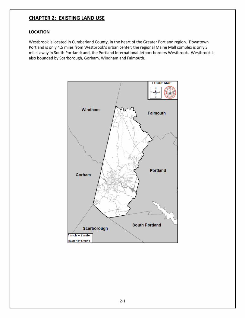
LOCATION Westbrook is located in Cumberland County, in the heart of the Greater Portland region. Downtown Portland is only 4.5 miles from Westbrook’s urban center; the regional Maine Mall complex is only 3 miles away in South Portland; and, the Portland International Jetport borders Westbrook. Westbrook is also bounded by Scarborough, Gorham, Windham and Falmouth.
2‐1

2‐2

OVERVIEW Following the adoption of the 2000 Comprehensive Plan Westbrook adopted a new zoning ordinance. These districts and standards follow the guidance of the 2000 Comprehensive Plan. Substantial new development requires Planning Board approval, by Site Plan or Subdivision approval. Subdivision approval is required consistent with state law. Site Plan approval is not required for 1‐ or 2‐family dwellings and is otherwise required with an increase in impervious surface over 3,000 square feet. This could be a parking lot and/or a new or expanded structure. New Site Plan or Subdivision development has been consistent with the Comprehensive Plan. A challenge that most communities experience is development of substandard residential lots. Westbrook continues to refine its design standards for this type of development to help ensure compatibility with surrounding homes and lots. Westbrook has adequate administrative capacity to manage its land use regulation program. SUMMARY OF DEVELOPMENT ZONES AND STANDARDS 301 City Center District The purpose of the City Center Zoning District is to create a flexible atmosphere for the return of the downtown to a prominent regional service center. Flexible setbacks will be balanced with an overlay of design standards to encourage new development that will be consistent with the goals established in the City’s Comprehensive Plan, Downtown Revitalization Plan, Downtown Parking Plan, Downtown Streetscape Plan and Westbrook Riverfront Master Plan. 302 Residential Growth Area 1 The purpose of the Residential Growth Area 1 zone is to provide urban core community densities to support the downtown center. Reduced setbacks will permit the infill of vacant properties in areas that are already served by municipal infrastructure. 303 Residential Growth Area 2 The purpose of the Residential Growth Area 2 is to develop suburban neighborhoods in areas that can be easily served by municipal infrastructure. This zone is a mixture of older subdivisions and vacant land that would best be served with interconnected road systems. Development, through density incentives, is encouraged to bring water and sewer to sites. 304 Residential Growth Area 3 The purpose of this more rural zone is to create a similar growth pattern with the Falmouth border. This zone also recognizes that public sewer is not likely to be extended in the near term. While the area is rural in character, there is not an abundance of farm lands. The cluster density incentives are designed preserve more open space, particularly around the Minnow Creek watershed. This zone is also designed to maintain the rural character along Duck Pond Road and Route 302. 305 Prides Corner Smart Growth Area
2‐3
The purpose of this “smart growth” area is to establish a growth pattern that is anti‐sprawl in nature. The standards for this zone will be flexible, encouraging a mixture of residential uses, as well as limited commercial and industrial activity. It is the intent of this zone to follow the goals and objectives outlined in “The Great American Neighborhood – Westbrook Route 302 Public Charrette.” The map, scheme A is referenced as part of the zoning map for the purpose of directing the pattern of development.

306 Rural District The purpose of the Rural District is to provide an area of rural quality consistent with the Comprehensive Plan. Standards permit clustering and focus on preserving open space and important vistas. The uses for the rural district are also more consistent with farm and low‐density development. 307 Highway Services District The Highway Services district is comprised of the small commercial/retail areas located in the following areas: Methodist and Duck Pond Road neighborhood; Pride’s Corner Center; Spring Street at the city line; and small individual sites along Pride Street. . The standards are meant to be flexible, but geared to improve appearance and reduce sprawl in these important mixed‐use gateway centers. 308 Business/Professional Office District The Business/Professional Office District consists of approximately 102 acres of land accessible by Exit 7B or the Westbrook Arterial. Because of the proximity of this land to the farmlands and open residential character of the Stroudwater Rural Neighborhood, the City will limit commercial development of these properties to primarily business/professional office and light manufacturing uses. The large acreage require that the area be master‐planned, creating a quality campus atmosphere that results in both high‐wage employment and a harmonious relationship with surrounding farmland and residential properties. Only limited retail support uses will be permitted. 309 Gateway Commercial District This district is designed to provide for a regional retail center that takes advantage of major transportation linkages. The use of land in this zone is to be maximized, but according to a set of standards as part of the community’s gateway planning. 310 Industrial Park District The Industrial Park District includes the City’s largest developed industrial parks. Some of these existing facilities are in need of upgrade, while others have the capacity to expand. Setback and lot standards have been relaxed to encourage such investment. 311 Manufacturing District This district is located south of the Stroudwater River, north of the electric transmission power line easement, and between Saco Street and Spring Street. Performance standards for uses in this district are designed to maintain compatibility between differing uses. All uses and activities must be conducted within the principal building. Such uses are capable of operating in a manner that controls the external effects of the manufacturing process, such as sound, odors, vibrations, emissions, dust, glare, or other nuisance characteristics, through prevention or mitigation devices, and of conducting operations, within the confines of buildings. 401 Shoreland Protection Zone
2‐4
The purpose of these overlay zoning districts is to maintain safe and healthful conditions; to prevent and control water pollution; to protect fish spawning grounds, aquatic life, bird and other wildlife habitat; to protect buildings and lands from flooding and accelerated erosion; to protect archaeological and historic resources; to protect water dependent industries; to protect freshwater wetlands; to control building sites, placement of structures and land uses; to conserve shore cover, visual as well as physical points of

2‐5
access to inland waters; to conserve natural beauty and open space; and to anticipate and respond to the impacts of development in shoreland areas. 402 Flood Plain Zone. Areas of the city are subject to periodic flooding that cause serious damage to properties. Relief is available in the form of flood insurance, as authorized by the National Flood Insurance Act of 1968. The City has chosen to become a participating community in the National Flood Insurance Program, and has agreed to comply with the requirements of the National Flood Insurance Act of 1968 (P.L. 90‐488, as amended) as set forth in this Floodplain Management Ordinance. By adopting this Ordinance, the City intends to require the recognition and evaluation of flood hazards in all official actions relating to land use in the floodplain areas having special flood hazards. The City has the legal authority to adopt land use and flood control measures to reduce future flood losses pursuant to Title 30‐A M.R.S.A., Sections 3001‐3007, 4352 and 4401‐4407. 403 Village Review Overlay Zone. The Westbrook Comprehensive Plan calls attention to both national and local historic district properties. A survey by Greater Portland Landmarks identified potential national historic districts and four local districts. The Village Review Overlay Zone, corresponding to these areas, will provide architectural guidance to property owners within the zone. No change, as determined through the criteria of Section 403.5, to the exterior of an existing building, no addition to an existing building, or any new construction shall occur in the Village Review Overlay Zone without the approval of either City Staff or the Planning Board, as set forth in Section 403.8. The following criteria will guide owners in the maintenance of important architectural qualities of the property, or creating new ones that relate to surrounding properties. 407 Downtown Housing Overlay District The purpose of the Downtown Housing Overlay District is to allow residential uses at densities that will complement the efforts to revitalize the City’s downtown into a prominent regional service center. The addition of higher density housing will increase activity downtown after the nine‐to‐five business hours, and provide more patrons for downtown service businesses. In accordance with the Comprehensive Plan, along William Clarke Drive, Bridge Street and Main Street, multi‐family housing is permitted on all floors except the sidewalk level, thus preserving the availability of ground‐floor commercial space. 408 Residential Growth Area 1 Business Office Overlay Zone The purpose of this overlay district is to allow limited business offices in existing structures within the Residential Growth Area 1. Businesses must receive a Special Exception to locate within the district. Particular interest will be paid to the potential impacts of businesses upon adjoining residential uses. In particular, parking, traffic and building appearance will be taken into consideration.

2‐6
Table 2‐1 City of Westbrook Zoning with Performance Standards
Zone Minimum Lot Size (If an existing lot is divided it too is a new lot)
Dimension Requirements (width measured on a public or private way)
Front Setback
Rear Setback
Side Setback
Max. Height Max. Footprint Factor (footprint of building as % of total site area)
Max. Gross Density Factor (all impervious area as % of total site)
Landscape Factor (remainder after max. gross density)
Residential Density Factor
City Center District (See Ordinance for Overlay Districts)
None None None None None Negotiable 100% 100% See Ordinance
1:2,500 sf 500 sf:unit size. 150 sf:additional bedroom
Residential Growth Area 1 (see Ordinance for Overlay Districts)
5,000 sf existing 7,500 sf new
50’ existing 65’ new
15’ 15’ 10’ existing 15’ new
40’ 40% 70% 30% 1:5,000 sf
Residential Growth Area 2
10,000 sf w/ sewer 20,000 sf w/o sewer
75’ for 10,000 sf. If no sewer See Ordinance
10’ existing 15’ new
10’ existing15’ new
10’ existing 15’ new
35’ or 2.5 stories 30% 40% 60% 1:10,000 sf See Ordinance if no sewer
Residential Growth Area 3
60,000 sf or 40,000 sf cluster
100’ 30’ 15’ cluster
30’ 15’ cluster
20’ 15’ cluster
35’ or 2.5 stories 15% 25% cluster
25% 40% cluster
75% 60% cluster
1:60,000 sf 1:40,000 cluster
Prides Corner Smart Growth Area
5,000 sf w/ sewer. 20,000 w/o sewer
50’ 10’ 10’ 8’ 50’ 40’ (for whole zone, none per lot)
50’ (for whole zone, none per lot)
50% (for whole zone, none per lot)
1:15,000 (for whole zone, none per lot)
Rural 60,000 sf 20,000 sf cluster
200’ 100’ cluster
30’ 15’ cluster
30’ 15’ cluster
30’ 15’ cluster
45’ 25% 40% 60% 1:40,000 sf
Highway Services 15,000 sf 100’ 30’ 30’ 30’ 40’ or 3 stories 40% 75% 25% N/A Gateway Commercial
10,000 sf 100’
20’ 20’ 20’ 40’ or 3 stories 50% and 160,000 sf per building
75% 25% None
Business Professional Office
20 acres 200’ 30’ 50’ 50’ 50’ 40% 60% 40% N/A
Manufacturing 20,000 sf 200’ 40’ 30’ 30’ 75’ or 5 stories 50% 80% 20% N/A Industrial Park 20,000 sf 200’ 40’ 30’ 30’ None 50% 80% 20% N/A
Zoning ordinance contains stipulations not shown here – reviewing ordinance is recommended.

SUMMARY OF NEW DEVELOPMENT
Table 2‐2 New Development 2000‐2010
Residential Units 850Commercial 49Industrial 27Institutional 13Notes – Residential includes all unit types. Commercial includes significant building expansions and new buildings. Institutional includes new or significant expansion of municipal buildings, nursing homes and hospitals.
Source – Westbrook Building Permit Database
Table 2‐3 Listing of Primary Development
2000‐2010 Projects are built or under completion and required Site Plan, Subdivision and/or Paper Street approval.
2‐7
Unit Count Brief Description Residential (10 unit
min.)
Cobb Farm Drive 22 Cobb Farm Estates – Single‐Family Stillwater Drive 33 Presumpscot Estates ‐ Detached Condominiums Lincoln Street 17 Rivermeadow – Duplex Condominiums Reed Street 23 Multi‐Family Affordable Rentals in 5 Buildings. Stagecoach Lane 12 Stagecoach Station – Duplex Condominiums Conant Street 12 Gateway Condominiums – Semi‐Detached Wilson Drive 18 Single‐Family Presidential Way 36 Presidential View – Single Family Country Lane 15 Single‐Family Harrisburg Avenue 15 Duplex Condominiums Everett Court 16 Semi‐Detached Condominiums 345 Saco Street 26 Risbara – Multi‐family and Townhouse Condos in 10 buildings Victoria Street 31 Victoria Heights – Single Family Mayfield Drive 21 Single‐Family Wildwood Circle 15 Single‐Family Brydon Way 76 Brydon Farms – Duplex Condominiums
Chase Hill Drive 16 Single‐Family Lincoln Street 26 Golder Commons 26‐unit affordable housing 115 Saco Street 18 Duplex Condominiums Ethel Avenue 15 A Mix of Duplex and Triplex Condominiums
Merganser Street 26 Single‐Family Dale Avenue 26 Mostly Single‐Family with Some Duplex Kennard Street 12 Single‐Family

Osaka Street 12 Single‐Family Ash Street 34 Westbrook Housing‐ Affordable Senior Multi‐Family Rentals
=573
Commercial Spiller Drive N/A Sigco, Inc. ‐ Warehousing/Office Building One Riverfront Plaza
N/A Disability RMS – 6‐story office building
County Road N/A Westbrook Cinemagic – 16‐screen theater William Clarke Drive
N/A Hannaford Supermarket
10 Thomas Drive N/A Warehouse Eisenhower Drive N/A Remstar – Office/Warehouse Expansion Main Street N/A Ruby Tuesday – Restaurant 25 Thomas Drive New Building Main Street N/A Shaws Supermarket Terminal Way Patrick Drive – Office/Retail/Warehouse Building William Clarke Drive
N/A Saco Biddeford Savings Institution
Main Street N/A Kentucky Fried Chicken/Taco Bell Eisenhower Drive N/A Bissen Moving & Storage Building 4 Thomas Drive N/A Warehouse/Office Building
Warren Avenue N/A 84 Warren Ave – Multiple Warehouse buildings
Industrial Scott Drive N/A Maine Medical Center Laundry Facility One IDEXX Drive N/A IDEXX – Multiple Expansions of a Manufacturing Facility
Institutional Utility ROW N/A Maritimes Northeast Multiple Institutional and Office Buildings Stroudwater Street
N/A Westbrook Middle School and 1,000 seat Performing Arts Center
Main Street N/A Westbrook Public Safety Building County Road N/A Spring Harbor Hospital – 2‐story 100‐bed psychiatric hospital
2‐8

Table 2‐4 Vacant and Developed Acres by Zoning District
Zoning District Total Acres Developed Acres
Vacant Acres % Developed
Business Professional Office 49 18 31 37% City Center District 201 182 19 90% Gateway Commercial 410 410 0 100% Highway Services 64 34 30 53% Industrial 20 20 0 100% Manufacturing 489 448 41 92% Industrial Park 1,127 978 149 87% Prides Corner Smart Growth Area
451 262 189 58%
Residential Growth Area 1 1,548 1,484 65 95% Residential Growth Area 2 1,786 1,411 375 79% Residential Growth Area 3 1,170 915 255 78% Rural District 2,565 2,302 263 89% Contract Zone 250 154 96 62%
Source – Total Acres per zone provided by the Westbrook Assessing Department Notes: Developed Acreage refers to existing uses appropriate for the designated zone. For example, residential units located in an Industrial Zone would not be tabulated as a "Developed" industrial lot. Therefore, while lots may be developed, if they are not developed appropriate for that zone then they are available to be developed appropriate for that zone and so are depicted as “Vacant Acres”. Undeveloped lots are be tabulated as “Vacant Acres”. Developed acres may not be developed to their highest capacity. Undeveloped acres, or less developed acres, may be that way due to environmental constraints that would otherwise prevent or limit their development. In addition, many “Vacant Acres” do not have access to a public or private way and therefore are not yet developable, but may become so with a legal connection to a public or private way. DEVELOPMENT CAPACITY • Commercial Development: Downtown Westbrook (City Center District) appears to be built out,
however the current zoning ordinance allows for zero setback development and building heights are negotiable. Buildings could expand or underutilized properties could be redeveloped taking advantage of these development incentives. The City has almost exhausted its supply of industrially‐ and manufacturing‐zoned property. Many buildings could expand, but “easy” sites are developed. The area near Maine Turnpike Exit 46 is ripe for development and has significant capacity. However, there is an active farm, zoned Rural, that will limit the commercial capabilities of this area. The Pike Industries Main Street facility is being phased out and given its lot size will some day provide an excellent boost to the commercial property tax base. This property is located in close proximity to Westbrook’s other highway access point, Maine Turnpike Exit 48. There is enough land available to accommodate demand for future commercial development.
2‐9

• Residential Development: There is little development capacity left in the RGA‐1 Zoning District, which abuts the downtown. Most residential development capacity is located north of Cumberland and East Bridge Streets. New roadways would need to be built to connect currently inaccessible tracts of land to existing roadways. Figure 2‐4 depicts the environmental constraints that hamper total build out of available tracts of land. Environmental constraints do not prevent development, but they can limit maximum build out. There is enough land available to accommodate demand for future residential development.
2‐10

2‐11

2‐12

CHAPTER 3: ECONOMY
Westbrook’s history as a mill town, driven primarily by its proximity to the Westbrook’s history as a mill town, driven primarily by its proximity to the Presumpscot River and Saccarappa Falls, defined the community and its economy well into the 20th Century. The reduction in paper mill employment served as a catalyst for the city’s new economic identity. Through the 1990s, the city began to realize this identity focusing new economic development on technology based industry. This focus continued into the first decade of the 21st Century along with an increased focus on the downtown’s role as a regional service center. Westbrook is poised to grow its economic base with the public infrastructure necessary to perform competitively in the region. ECONOMIC TRENDS The last third of this decade was marred by an economic recession. Thus, the economic indicators reflecting the trends between 2000 and 2009 should be read taking this into account. Employment Growth
Table 3.1 ‐ Employment by Occupation, 2000‐2009
2000 2009 2000‐2009 No. of
Empl % of Total
No. of Empl
% of Total
(+/‐) % Change
Total 8380 100 7999 100 ‐381 ‐6Mngmnt, Professional, etc. 2366 28 2548 31 182 8
Service Occupations 1321 16 1289 16 ‐32 ‐2Sales and Office 2808 34 2458 31 ‐350 ‐13Farming, Fishing, Forestry 20 .2 15 0.2 ‐5 ‐25
Construction/Extraction 581 7 619 8 38 7Production/Transportation 1284 15 1070 13 ‐214 ‐17
Source: 2009 American Community Survey (ACS) In 2000, the largest sector of employment in Westbrook was sales and office work, which employed over one‐third of all Westbrook employees. By 2009, sales and office employment was overtaken by the management and professional field, which saw a net gain of 182 employees over that same time period. The loss of 350 sales and office employees was a significant one, amounting to a 12.5 percent decrease in employment in that field in Westbrook, and symbolizing a decreasing role of that work in Westbrook’s economy. However, the addition of 182 jobs in management and professional work shows economic growth in that industry in Westbrook, largely due to the location of Disability RMS at One Riverfront Plaza in 2004.
3‐1
STATE GOAL: Promote an economic climate that increases job opportunities and overall economic well‐being.

Table 3.1 shows an overall loss of employees and a shrinking economy. Westbrook’s performance over this time period is best measured against neighboring municipalities dealing with the same economic trends, and against the region as a whole. Table 3.2 shows employment growth or loss from 2000 to 2009 in a selection of towns in greater Portland and Cumberland County as a whole.
Table 3.2 ‐ Employment by Occupation, 2000‐2009
Source: 2009 ACS Table 3.2 shows that Westbrook’s economy did not perform as well as its neighboring towns and cities. Westbrook is the only municipality on the table to lose overall employment between 2000 and 2009. Compared to its five neighboring communities, Westbrook’s job growth has been at or near the bottom in total employment growth, management/professional job growth, service sector job growth and sales/office jobs growth. More specific data may tell a different story. For example, according to the 2010 Maine Manufacturers Register, an industrial directory published annually by Manufacturers’ News, Inc., Westbrook is one of two municipalities in Maine that did not lose manufacturing jobs between 2008 and 2010. However, when lumped into the broader category of “production and transport,” and when employment figures are seen only in the context of a full decade, Westbrook’s success story is lost. The single largest impact on employment in Westbrook over the last decade was the change in course initiated by S.D. Warren, now known as Sappi Fine Paper (Sappi). Beginning in 1996 Sappi began to close down its traditional pulp and paper function. At its height in the late 1970s, Sappi employed over 3,000 people. Sappi maintains a strong presence in Westbrook, with just over 400 employees, and has transformed into a technology intensive operation as the world’s leading supplier of release or “specialty papers,” which provide the surface aesthetics, found in plastic‐coated fabrics used in footwear, clothing, upholstery and accessories. Release papers are also used to add texture to decorative laminates found in kitchens, baths, flooring and other decorative surfaces. Unemployment Rate Between 2000 and 2010, unemployment in Westbrook rose from 2.57% to 6.89% due to an economic recession that was felt throughout the region and the country. Westbrook has had a slightly higher rate of unemployment when compared to neighboring communities and Cumberland County. However,
3‐2
TOTAL Emp.
Mgmt/ Prof.
Services Sales/ Office
Const./ Extraction
Production/ Transport
(+/‐) % (+/‐) % (+/‐) % (+/‐) % (+/‐) % (+/‐) % Cumberland County
8463 6 5319 10 4146 21 ‐734 ‐2 ‐1492
‐13 ‐1540 ‐10
Westbrook ‐458 ‐6 182 8 ‐32 ‐2 ‐350 ‐13 38 7 ‐214 ‐17 Gorham 370 5 216 8 21 2 353 16 ‐133 ‐21 ‐99 ‐12 Portland 137 1 458 3 710 12 ‐959 ‐10 171 9 ‐180 ‐5 Scarborough 1275 14 857 22 301 32 287 11 83 19 ‐247 ‐30 So. Portland 1290 10 1344 30 ‐83 ‐4 ‐445 ‐11 ‐50 ‐6 ‐53 ‐4 Windham 862 11 994 38 262 22 ‐187 ‐8 171 23 ‐335 ‐30

Westbrook’s performance has been substantially similar, in terms of fluctuation, to its neighbors and Cumberland County as a whole. Westbrook has neither significantly underperformed nor exceeded the performance of the county and neighboring municipalities. Unemployment remains high throughout Cumberland County. Westbrook Businesses There are several business sectors that dominate the employment landscape in Westbrook and these are health care, insurance and manufacturing. IDEXX Laboratories, Inc., a developer of diagnostic tools for large and small animals, is currently the city’s largest employer, and showed considerable growth over the last decade. In 2001, IDEXX reported having 754 employees in Westbrook. By 2007, IDEXX’s Westbrook employee count doubled, reaching 1512, and the company continued to grow. Including IDEXX in the health care sector, this sector includes over 2,200 jobs in Westbrook. The insurance sector includes over 500 jobs in Westbrook. Finally, the manufacturing sector, which historically has been the largest employment sector in Westbrook, continues to play a critical part in the economy. While Sappi employs over 405 people there are many smaller manufacturing companies and there are three mineral extraction/aggregate production facilities in Westbrook. The mineral extraction activity has taken place in Westbrook for many, many decades. The region is fortunate to have so much high quality stone that is accessible as this product is refined and may be used to pave the roads in Southern Maine, the economic engine of the state, to pave the parking lots on which we leave our cars as we go to work and to build high quality commercial buildings. If there were no mineral extraction in Southern Maine then the cost to build these components of our economy could be more expensive as the product would have to be transported from outside the area. Westbrook is very fortunate and somewhat unusual for a community of its size, to have such a diverse economy.
Table 3.3 ‐ Top 10 Employers by Size (+150 full time employees in Westbrook)
2011
Company Name Size Class IDEXX Laboratories 1665 Westbrook School Department 550 Spring Harbor Hospital 420 Sappi Fine Paper 405 Disability RMS, Inc. 321 City of Westbrook (municipal) 250 Bill Dodge 178 Sysco Food Services 175 Acadia Insurance 162
Source: Department of Planning
Workforce Education
3‐3
As discussed in Chapter 1, Population and Demographics, Westbrook has the highest percentage of the population with less than a high school degree in greater Portland, also exceeding the percentage for Cumberland County. In 2000, Westbrook had been equal to Cumberland County in this respect, but while the percentage in Cumberland County decreased, Westbrook saw a sharp increase over the next

decade. In both 2000 and 2009, Westbrook was last among greater Portland municipalities in workers with bachelors or graduate and professional degrees, and fell behind Cumberland County in both categories. While Westbrook’s overall workforce educational attainment has improved since 1990, the improvements have not been sharp enough to step ahead of any of its neighboring communities, and it still falls short of Cumberland County as a whole in its workforce’s education level. Commuting to and from Westbrook Table 3.4 shows the top ten cities and towns where Westbrook residents reside, and the top ten cities and towns where Westbrook employees work. The data relied on for this analysis dates from the 2000 Decennial Census because the data was not collected in the 2010 Census, and more recent data is not available on commuting patterns. Assuming these figures are still relevant in 2011, a few conclusions can be drawn. These figures show that the dominant commuting pattern is between Westbrook and Portland. There is additional east‐west traffic coming into Westbrook from Gorham, Windham, South Portland and Standish, as well as leaving Westbrook and going to South Portland, Scarborough, Gorham and Windham. This data supports the conclusion that the most heavily travelled commuter routes in Westbrook are its east‐west corridors. At the same time, the fact that approximately 25% of Westbrook residents also work in Westbrook reveals that Westbrook has a strong and attractive job market, relative to many nearby communities.
Table 3.4 – Commuting Patterns In and Out of Westbrook, 2000 Source: 2000 US Census As demonstrated in Table 3.3, IDEXX Laboratories, Inc. is the largest employer in Westbrook, with almost four times more employees than the next largest employer, Disability RMS. IDEXX has three locations in Westbrook: 1 IDEXX Drive, 1 Thomas Drive and 1 Riverfront Plaza. The majority of IDEXX’s Westbrook employees (1,240) work at the 1 IDEXX Drive location in the Five Star Industrial Park. IDEXX draws a majority of its employees from Portland, Scarborough, Gorham and South Portland, in descending order. Similar to the conclusions drawn from Table 3.4, an east‐west commuting pattern is dominant. It is also
3‐4
Westbrook Employees Commute From . . .
Westbrook Residents Commute To . . .
Town/City of Residence
% of Westbrook Employees
Town/City of Employment
% of Westbrook’s Labor Force
Westbrook 22 Portland 40 Portland 14 Westbrook 26 Gorham 7 South Portland 12 Windham 6 Scarborough 5 South Portland 5 Gorham 3 Standish 5 Windham 2 Scarborough 4 Falmouth 2 Buxton 3 Brunswick 2 Gray 2 Yarmouth 1 Saco 2 Freeport 1

worth noting that the neighboring communities making up the highest percentage of IDEXX’s Westbrook employees are also the communities which have the highest percentage of labor force members with bachelor’s degrees and professional/graduate degrees. Westbrook workers make up approximately 8% of IDEXX’s employees but could perhaps take greater advantage of the company’s presence in town if its workforce had a higher level of education attainment. CURRENT ECONOMIC INVENTORY At this point in the city’s life cycle, there is a shortened supply of undeveloped land, and as a result, growth will increasingly rely on in‐fill development. In‐fill, generally, is more expensive than building on previously undeveloped lots, and this presents a challenge for future economic development. Areas Designated for Industrial Growth
• Industrial Park Districts. Westbrook has zoned two Industrial Park Districts. The first encompasses much of southern Westbrook, divided by County Road and stretching from the town’s eastern border to Saco Street in the west. The second, smaller Industrial Park District is located along Warren Avenue in eastern Westbrook. Westbrook’s land use ordinance includes standards in the Industrial Park District to ensure compatibility with surrounding uses.
• Manufacturing District. Westbrook added a new district in 2010, south of the Stroudwater
River and between Saco and Spring Streets, with the idea of promoting the area as a location for technology based businesses. The ordinance includes performance standards to ensure compatibility between uses within the zone and with uses in the surrounding zones.
Areas Designated for Commercial Growth
• Business Professional Office District. This district is located adjacent to I‐95, and exit 48. It is targeted for office park or business‐campus development, allowing for professional offices and/or technology based industry with specific standards to be compatible with the surrounding farmlands and residential neighborhoods.
• City Center District. Development standards in the City Center District are designed to direct
economic growth towards the downtown area and reestablish it as a prominent regional service center. A wide variety of uses are allowed, there are no setback requirements, building height is negotiable and parking is not required for most commercial uses. There are overlay zones that enable high‐density housing and that are intended to maintain the historic and architectural character of the downtown.
3‐5
• Pride’s Corner Smart Growth Area. This zone sits astride a section of Route 302 in north Westbrook. The zone has flexible standards to promote anti‐sprawl development patterns. The zone is targeted for a mixture of residential and commercial activities. However, despite these goals and its designation, little commercial development has occurred in the zone because it lacks connectivity to the public sewer system. The extension of public sewer in this area may be appropriate, if the expense is not born by the City of Westbrook.

• Stroudwater Place/500 Westbrook LLC Contract Zone. Stroudwater Place sits between Stroudwater Street and the Westbrook Arterial, occupying 61 acres of undeveloped land. The Westbrook City Council approved a contract zone on this land for the purpose of allowing high‐quality, master planned, mixed‐use commercial development, which would serve as a regional commercial hub. While the property remains undeveloped it is zoned for a mix of uses. The contract zone requires compatibility with current surrounding uses by including requirements for physical and special buffers, traffic control, parking, and noise and light pollution.
Westbrook’s Downtown The downtown area has seen a significant amount of development and re‐development in the last 10 years aided by zoning and economic incentives, public investment, private investment and public‐private partnerships. Many such examples are included below in order to illustrate how the downtown is thriving.
• Zoning. As noted above, the city’s Land Use Ordinance has zoned a City Center District, designed to direct economic development to the downtown, with the vision of restoring the area to prominence as a regional service center. The zoning for this area is flexible in both promoting this growth as well as for protecting the historic and architectural qualities of the area which make it unique.
• Downtown Tax Increment Financing (TIF) District. A TIF was implemented in 2002 which
encompassed most of downtown. TIF is a method to use future gains in taxes to finance current improvements (which theoretically will create the conditions for those future gains). The increased tax revenues are the "tax increment." Tax Increment Financing dedicates tax increments within a certain defined district to finance debt issued to pay for the project. TIF is designed to channel funding toward improvements in distressed or underdeveloped areas where development might not otherwise occur. TIF creates funding for "public" projects that may otherwise be unaffordable to localities, by borrowing against future property tax revenues. TIF revenue from the Downtown TIF District is used to fund additional improvements to the downtown area. As will be described later, this TIF has benefitted a number of different properties and served as a catalyst for multiple development plans in the downtown area. In 2004, TIF was also used at the Dana Warp Mill property to assist in its redevelopment. Today, the property has attracted office‐based businesses\light manufacturing and other businesses including a fitness gym, a theater group and a martial arts school.
• Public Investments. The city has been active in making investments in the downtown area.
Significant investment in the public way has been as a result of public planning processes, such as the Riverfront Master Plan and the Downtown Streetscape Plan. The city constructed the Westbrook Riverwalk and Riverbank park along the Presumpscot River and within a short walking distance of downtown offices, restaurants, residences and services. In 2004 the City of Westbrook completed a new 23,800 square foot facility for the police, fire and emergency medical service departments on Main Street.
3‐6

• Public‐Private Partnerships. The city has been diligent in partnering with private companies to forward the city’s economic development goals. Implementation of public private partnerships is an on‐going strategy that involves staff and the municipal administration.
o Most recently, the city was awarded Community Development Block Grant (CDBG)
funds to assist a property owner in removing and redeveloping a large building on Main Street which has been classified as “urban blight”. Westbrook has also been awarded CDBG funds to begin the first publicly funded component of the Downtown Streetscape Plan.
o Westbrook Housing, taking advantage of federal and state rehabilitation tax credits as well as low income housing tax credits, adaptively reused the historic high school building on Main Street to create 29 units of affordable senior housing.
o Perhaps the most notable and successful public‐private partnership came in the redevelopment of the former Foye Mill at 59 Dana Court. The city utilized an EPA Brownfields grant and tax increment financing to assist in the redevelopment of the site to include office space and a parking garage. After a $16 million private investment, the offices now houses Disability RMS, a national leader in disability risk management products and services, which employs approximately 350 people.
• Private Investment. Private investment has been significant in Westbrook’s downtown and has
contributed to the reemergence of the area over the last decade. o 869‐873 Main Street (The Warren Block). This building, listed on the National Register
of Historic Places, sits in a highly‐visible location, at the corner of Main and Bridge Streets in the heart of downtown Westbrook. The building underwent a privately‐funded $11 million floor to ceiling renovation in 2006. Currently, it is home to a restaurant, business services and offices.
o Restaurants/Cafes. The downtown has seen tremendous growth in the number of restaurants and small shops over the last decade. The Frog and Turtle, several coffee houses, Portland Pie, Blue Burrito Café, and Fajita Grill have opened in the last decade and excelled in downtown locations where previous restaurants have closed. Each of these businesses operates with private financing.
o Maine Medical Partners. In 2007, Maine Medical Partners invested $2.3 million dollars to open an 11,250 square foot medical office space on the corner of Main and Cumberland Streets.
Tourism. Tourism has not been a significant part of Westbrook’s economy and it is not a targeted area for economic development.
Civic Events The city features a number of civic events designed to attract people to Westbrook and to showcase the community. An on‐going implementation strategy is to increase the exposure of Westbrook through civic events. This will continue to involve staff, the municipal administration and public and private partners.
3‐7

• Most notably, Westbrook Together Days occurs annually over a summer weekend, and features a parade through downtown and a two‐day festival in Riverbank Park with music, vendors and attractions for all ages.
• In the winter, the Dana Warp Mill hosts the Mill‐ieu and Photo a Go‐Go event, which brings together the Bakery Collective Photographic Group, the Acorn Productions theater group and other creative organizations based in the mill, for a night of art, music and celebration.
• The City of Westbrook has invested $4.7 million in a 1,000 seat performing arts center, located at the site of the new middle school. It has proven to be an important community resource.
• Acorn Productions, a theater group residing in the Dana Warp Mill, presents “Shakespeare in the Park” each Spring. The plays are performed in Riverbank Park on Main Street, and are free to the public.
• Westbrook has become an attractive location for organizations hosting sports tournaments and other events because of its outstanding athletic fields and performance venues. Examples include:
o The Westbrook Paper City Classic basketball tournament has attract teams of 5th and 6th grade boys and girls from towns and cities all over Maine for the past 19 years.
o The Maine One Act Festival features one act plays written and performed by Maine high school students. Nearly 80 high schools participate at rotating venues, and the performances are well attended by students and the public. Westbrook has hosted One Act Festival performances on several occasions.
o Westbrook has a long history of supporting its community sports teams, including Westbrook High School athletics, Westbrook Little League, and Westbrook Tuffy Football.
Home Occupations The city’s land use ordinance allows and welcomes the establishment of home‐based occupations, provided that they meet certain standards. However, the city’s economic strategy focuses on business development in areas designated for business growth including the downtown area, business and industrial parks, and other areas specifically zoned for such growth. ECONOMIC DEVELOPMENT ACTIVITY Economic Development Priorities Guided by the 2000 Comprehensive Plan, the city generated the 2007 Strategic Economic Development Plan. The priorities for economic development activities in the city are succinctly set forth in that document and are summarized below. The following implementation strategies are to be implemented on an on‐going basis with the involvement of staff, the municipal administration and local and regional public and private partners.
3‐8
• Marketing and Promotion. The city’s reinvention and new identity in the post‐paper mill economic era began with telling those inside and outside of Westbrook about the positive direction in which the city is moving. The ad campaign continues to play up the city as a

convenient, safe and comfortable place to live, as a center of the arts and culture, and as an excellent place to begin or to locate a business.
• Downtown Revitalization. The city continues to focus development efforts on its downtown.
The Downtown Streetscape Study, completed and adopted by the city in 2009, sets out a proposal for the design of streets, walkways, buildings and other public infrastructure so as to promote walkability and economic development. The city continues to support businesses looking for space in the downtown by marketing vacant commercial space, and assisting with financing through TIF, revolving loan funds and other programs.
• Promoting Energy/Utility Cluster. The Calpine power plant and the city’s location on the
Saccarappa River uniquely position the city to capitalize on the state‐wide initiative to establish heating, steam, electrical and local utility districts.
• Regional Cooperation. Westbrook has worked closely with Greater Portland Council of
Governments, and the Metro Coalition, who has encouraged the creation of a new regional economic development cooperative, the Greater Portland Economic Development Corporation (GPEDC). The GPEDC was formed in 2010, and is a public‐private partnership of the regional municipal economic development offices, the Education Alliance (USM/SMCC/UNE) and the Greater Portland Chamber of Commerce. Its goal is to further economic opportunities of the six communities active in the Metro Coalition: Westbrook, Portland, South Portland, Scarborough, Cape Elizabeth and Falmouth.
• Monitoring and Pursuing Grant Opportunities. Westbrook’s Department of Economic and
Community Development works closely with the Maine Philanthropy Center, and utilizes a number of public and private resources to monitor and pursue grant opportunities. The city continues to pursue and be awarded CDBG funding for improvements in the downtown. The city also received CDBG funds to participate in a Home Share study to be conducted by the Community Development Office of Cumberland County. The City continues to manage and administer the existing Economic Development Administration (EDA) grant for the expansion of Five Star Industrial Park on Eisenhower Drive.
Tax Increment Financing Districts (TIF) Westbrook utilized tax increment financing to assist in development through the 1990s, and continued this practice through the first part of the following decade. Westbrook has used TIFs to benefit both specific projects and for larger areas targeted for future development. Since first using this financing incentive the state has eliminated business equipment from the calculation of the future gains that can count toward the increment.
3‐9

Table 3.5 – Active TIF Districts in Westbrook
Source: Westbrook Department of Finance (NOTES: TIF District #1 was originally set to expire in 2010, but was extended for an additional 15 year term. The TIF was also modified at that time so that 100 percent of TIF revenues are now allocated to WEIC. TIF #4 is no longer an active TIF district and therefore is not included. TIF #11 shows a decrease in assessed value because business equipment, once included in the assessed value, has since been exempted pursuant to state law. Additional recent improvements to the property are also not yet included in the assessment.)
Municipal Revolving Loan Fund The city also has a successful Municipal Revolving Loan Fund (MRLF) program. In total, the fund has provided almost $1.4 million in loans to Westbrook small businesses, and has been paid in full on the vast majority of these loans. The Revolving Loan fund has assisted with property redevelopment, business expansion, start‐up capital, and relocation costs for local businesses which could not otherwise obtain or qualify for the financing they needed. However, the city has seen a significant decrease in MRLF applications, and has not approved a loan from this fund since 2008. Currently, there are two active loans in repayment.
3‐10
TIF District
Inception Date
End Date Original Assessed Value
Current Assessed Value
#1 – Acadia/Glassworld
1995 2025 $538,500 $10,732,300
#2 – LANCO/FINECOR
1995 2015 $200,900 $2,484,300
#3 – SYSCO/ Jordan Meat
1996 2016 $324,700 $8,447,100
#5 – D&G Machine (5 Star Ind. Park)
1998 2018 $3,039,000 $6,525,900
#6 – Olympia/JE Gould (5 Star Ind. Park)
1998 2013 $260,000 $6,694,500
#7 – Calpine (5 Star Ind. Park)
2000 2020 $30,800 $155,149,000
#8 – HMW, Inc. (Fox51 Ledgeview Dr.)
2001 2011 $231,300 $2,727,100
#9 – Foye Mill/ One Riverfront Plaza
2002 2022 $613,200 $19,941,700
#10 – Downtown TIF District
2002 2022 $39,836,500 $26,707,100
#11 – IDEXX (5 Star Ind. Park)
2006 2026 $40,296,100 $20,818,700
The Westbrook Environmental Improvement Corporation (WEIC) WEIC was formed for the purpose of retaining and protecting of natural, scenic, or open space values of real property, protecting natural resources, and maintaining or enhancing air or water quality while fostering business enterprises within the city. WEIC is funded largely through grants and TIF revenues, and has been a useful economic development asset for the city. In 2004, the City Council approved a $200,000 loan from WEIC to the developers of the Westbrook Heights Business Park to finance engineering, design and construction costs. WEIC also played an important role in financing the downtown riverwalk. INVESTMENTS IN THE FUTURE Westbrook will continue the economic development strategies described herein and will take specific steps to create a stronger base for its future. Westbrook will focus on an education and workforce development system that strengthens its ability to compete for businesses and its residents to compete for jobs. Westbrook will continue to focus on public safety for all residents, workers and visitors. Westbrook will plan for, maintain and expand infrastructure and technology to continue to be an attractive place to do business.
3‐11
CHAPTER 4: HOUSING
OUR VISION FOR WESTBROOK’S HOUSING Westbrook will include housing that meets the needs of a wide range of household types (young families, singles, empty‐nesters, retirees, the elderly, etc.) with a broad range of incomes. While most of the housing stock will continue to be single‐family homes, Westbrook will continue to encourage a range of unit types. Westbrook will participate in programs that encourage the rehabilitation of housing in poor condition located in distressed neighborhoods. This vision will be implemented on an on‐going basis and will include the involvement of staff and housing providers. ANALYSIS The pattern of residential development in Westbrook established itself over a period of 250 years. The dense central city did not assume its present‐day form until the turn of the last century. Development in the northern part of the city has not been an exclusively post‐war event; rather it has progressed since the early 1800’s. However, since 1990, new single‐family development has concentrated in this area with additional housing occurring as infill in the neighborhoods immediately surrounding the urban core. This infill development was a recommendation of the 2000 Comprehensive Plan which placed an emphasis on focusing new residential development in areas served by public infrastructure. Recent residential development in the downtown has primarily focused on the adaptive reuse of historic structures into multi‐family renter and owner occupied housing and several new multi‐family rental buildings. In general Westbrook has no seasonal housing stock. During the 2000‐2010 planning period the number of larger housing units, units with 3+ bedrooms, grew to be a higher proportion of the total housing stock than it had been in the prior planning period. Today, approximately 50% of housing units contain 3 or more bedrooms. Homes with 3 or more bedrooms serve as a magnet for families with children and are attractive to higher income wage earners and newer larger homes typically have higher property values than smaller and older homes. At the same time, there is a significant demand for smaller units from first time home buyers, empty‐nesters and seniors. The empty‐nester and senior demographic is the highest growing age bracket nationwide and must be planned for. Young families and young singles are a target demographic as they add vitality to the community and are its future. These two demographic groups typically seek out 1‐ and 2‐bedroom homes, which account for the remaining 50% of Westbrook’s housing stock. (Source: 2009 ACS) The generous zoning in the downtown enables vertical growth beyond what exists there now. This vertical growth would be appropriate for renter or owner‐occupied housing. Reduced parking requirements and higher densities make housing in the downtown viable at market or affordable prices/rents. Westbrook has two designated mobile home parks and manufactured housing is permitted in all residential zoning districts. Lastly, Westbrook allows in‐law apartments and the program has been operating successfully. During the last planning period, the entire country has experienced a wide‐ranging economic decline and there does not appear to be a clear end in sight. In this time, the housing “boom” went “bust” and unemployment approached 10% nationwide. Home foreclosures, short sales and declining home values have been especially hard on the housing market. Maine did not experience the same level of inflated
4 ‐ 1
STATE GOAL: To encourage and promote affordable, decent housing opportunities for all Maine citizens.

home values as some other areas of the country, but we are feeling the housing “bust” nonetheless, and we continue to experience job loss statewide. In response to these conditions, and government calls for increased accountability and truth in lending, lending institutions have set more stringent requirements on granting home loans. In general, at the time of writing, prospective homebuyers must have a 20% downpayment, proof of income, excellent credit and less debt relative to income. Whereas, during the housing “boom”, lending parameters were much more flexible, enabling first time home buyers to enter the housing market and, likely, gain equity in their homes. While zero downpayment requirement and reduced credit and documentation may not be responsible lending practice, the current lending environment, plus fewer job opportunities and greater competition for jobs, is a difficult one to enter the housing market for the first time. If population growth in the subject planning period (2010‐2020) continues at a rate of 8% (Chapter 1, Table 1‐1) then the current population of 17,494 will grow to approximately 18,900. Given the current split between renter and owner occupied housing units, 40% and 60% respectively, and the persons per unit, 2.05 and 2.43 respectively, then 246 rental units and 369 owner occupied units will need to be constructed over the planning period, or a total of 615 new units, to meet the needs of anticipated new residents. Chapter 2, Land Use, Table 2‐2, illustrates that the market is likely to meet the needs of anticipated residents. Approximately 850 new residential unites were constructed during the prior planning period (2000‐2010). Of those new units, approximately 150 were designated affordable housing units and included a mix of owner and renter occupied homes. This means that approximately 17% of the new housing units constructed over the prior planning period were designated affordable units. This is a very impressive number given the robust housing market that we experienced in the middle of the decade. Sales prices rose dramatically, yet affordable housing providers, primarily Westbrook Housing in Westbrook, were able to play a significant role in the race to build new housing units. HOUSING AFFORDABILITY Despite the comparatively high number of affordable housing units constructed in the prior planning period, finding housing that is affordable is a significant challenge in the greater Portland region. Table 4‐2 illustrates this challenge and also depicts the nature of the problem for those earning less than the median income. According to this data, the majority of households in Westbrook cannot afford the median sale price of a home. This is not unique to Westbrook. An examination of the cost of housing in Westbrook is divided between homeowners and renters. Of occupied housing units, approximately 64% of units were owner occupied and 36% were renter occupied during the prior planning period.
Table 4‐1 2010, Percentage of Renter and Owner Occupied Housing
Gorham Portland Scarborough South Portland
Westbrook Windham
Renter Occupied
19% 57% 20% 39% 40% 20%
Owner Occupied
81% 43% 80% 61% 60% 80%
4 ‐ 2
Source: 2010 ACS

Table 4‐2 2008, Housing Affordability
(for‐sale units) Aff.
Index Median Sale Price
Median Income
Income Needed to Afford Median Price
Home Price Affordable at Median Income
Households Unable to Afford Median Home Price
80% of Median Income
Home Price Affordable at 80% of Median Income
Gorham 0.73 $242,300 $61,074 $83,881 $176,419 68% $48,859 $141,135 Portland 0.59 $217,000 $43,064 $72,933 $128,130 77% $34,451 $102,504 Scarborough 0.74 $299,000 $70,582 $95,052 $222,025 69% $56,465 $177,620 South Portland
0.80 $195,000 $50,757 $63,119 $156,809 62% $40,506 $125,447
Westbrook 0.65 $187,000 $44,177 $67,836 $121,781 78% $35,341 $97,424 Windham 0.80 $205,000 $52,135 $65,038 $164,330 73% $41,708 $131,464 Source: Maine State Housing Note: The affordability index is the ratio of home price affordable at the median income to the median home price for that municipality. An index of less than 1 indicates an affordability challenge.
Graph 4‐1
Local Monthly Housing Costs (mortgage) as Percentage of Household Income
Source: 2009 ACS
4 ‐ 3
28%
19%
12%
28%
13%
20% or less
20‐24.9%
25‐29.9%
30‐34.9%
35% or more

Graph 4‐2 Local Monthly Housing Costs (gross rent) as Percentage of Household Income
Source: 2009 ACS
Table 4‐3 2009, Rental Housing Affordability
Gorham Portland Scarborough South
Portland Westbrook Windham
Median Rent $813 $830 $1,110 $881 $788 $909 Households Paying +30% of income on Gross Rent
56% 50% 46% 51% 63% 69%
Source: 2009 ACS
Homeownership is not only a function of availability and price, but also the ability to obtain financing. Most mortgage institutions set a ceiling limit on home purchases to 30%‐35% of the buyer’s household income. Mortgage payments in excess of the 30‐35% range tend to place stress on a homebuyer’s ability to meet the other expenses of living including food, insurance, clothing, heat, and automobile debt service. Table 4‐1 illustrates that Westbrook is attractive for renters. According to Table 4‐3, the median monthly rent in Westbrook is slightly lower than that of nearby municipalities however over half of renters pay over 30% of their income to rent. As with mortgages, it is an accepted precept that monthly rent should not exceed 30%‐35% of the monthly household income.
4 ‐ 4
12%
6%
19%
50%
13%
19.9% or less
20‐24.9%
25‐29.9%
30‐34.9%
35% or more

According to Maine State Housing, Westbrook had approximately 1,307 subsidized units in 2008. This includes 521 family sized units, 398 Housing Choice Vouchers and 447 senior units. Housing Choice Vouchers are vouchers allocated by the federal government and typically distributed at the local level and are used to “buy down” rent in the private housing market. While the current stock of affordably priced housing equals approximately 18% of the total housing stock in Westbrook more affordably priced and senior housing will be needed to meet the needs of the current population and the population increase over the planning period. These needs will be met both locally and regionally. Based on the low affordability index we should not expect to fully address the affordability problem but the municipalities and our regional affordable housing partners will take steps to address the problem.
Table 4‐4 2008, Subsidized Units
Gorham Portland Scarborough
South Portland
Westbrook
Windham
Family Units 2,367 97 403 521 8 Housing Choice Vouchers 53 1,553 24 349 398 42 Senior Units 125 1,598 38 509 447 132 Special Needs Units 16 246 23 46 36 30 Total 194 5,764 182 1,307 1,402 212 Source: Maine State Housing CONDITION OF HOUSING STOCK Table 4‐5 illustrates that the bulk of new housing has gone to the residential communities of Gorham, Scarborough and Windham. The urban core has a greater share of the region’s older housing inventory. Fully 30% of Westbrook’s total housing stock was built prior to 1939. A housing issue that Westbrook continues to face is the high number of rental units that are in older buildings that are very poorly maintained.
Table 4‐5 Age of Housing Stock
Pre 1939 1940‐1959 1960‐1979 1980‐1999 2000‐2010 Gorham 20% 9% 18% 37% 16% Portland 50% 15% 15% 15% 5% Scarborough 8% 13% 20% 44% 15% South Portland 33% 24% 18% 16% 9% Westbrook 30% 17% 24% 18% 11% Windham 8% 8% 26% 40% 18%
4 ‐ 5
Source: 2009 ACS

Many of the housing units built prior to 1939 are located in and near the downtown. Many of these units are part of 3‐6 unit buildings and are used as rental properties with the owner located off‐site. Often times the buildings and the units located within them are in very poor condition. As housing stock declines in quality, their value also decreases, making it unlikely that owners will be willing to make needed investment. A downward spiral can be the result. In the recent past, Westbrook in conjunction with our housing partners used community development block grants and revolving loan funds to improve a number of buildings in poor condition in distressed neighborhoods. Such activities may be appropriate in this planning period. It is important to maintain a good housing stock in and near the downtown as these units have access to public transportation, public services and amenities such as sidewalks, parks, access to the Presumpscot River and the Walker Memorial Library as well as access to the many restaurants, shops and service businesses. Residents help to enliven the downtown after the daily 9 am to 5 pm population leaves. LOCAL & REGIONAL HOUSING INITIATIVES • The City of Westbrook works with Westbrook Housing, Westbrook Development Corporation, the
Rotary Club of Westbrook‐Gorham, the Westbrook Regional Vocational Center, Habitat for Humanity, Shalom House, Avesta Housing and the People’s Regional Opportunity Program (PROP), to develop affordably priced housing in single‐family homes, multi‐family housing and group homes.
• The Westbrook Land Use Ordinances allow for higher residential densities in areas with access to public water and sewer. Being on public water and sewer reduces up front and maintenance costs for utilities for homeowners.
• Densities range from up to 87 units to the acre in parts of the downtown to 5‐8 units to the acre on new lots in the residential district that rings the downtown. Higher residential densities reduce the per‐unit costs which can then be past on to the renter or owner.
• The Land Use Ordinances enable the Planning Board to reduce the parking requirement in the downtown or to allow for off‐site parking, which further reduces development costs.
LOOKING TOWARD THE FUTURE While looking at capacity for additional housing in terms of population per square mile could appear simplistic it does show that Westbrook has space to grow, particularly when one takes into consideration that Westbrook is 17 square miles in size and South Portland is 12 square miles in size and South Portland is twice as dense while being approximately two thirds the size of Westbrook. While
4 ‐ 6
Graph 4‐3Age of Local Housing Stock
11%
18%
24%
30%
17%
2000‐2010
1980‐1999
1960‐1979
1940‐1959
Pre‐1939

South Portland’s density might not be ideal for Westbrook, Graph 4‐4 clearly shows that there is room to grow here. For future residential development where the developer has chosen to build a unit type (generally multi‐family) or where the development will not be located on a roadway improved to the extent necessary to be accepted by the City for City maintenance and services, the City of Westbrook will take steps, as practicable, to inform buyers that their home will not have the benefit of these public services such as snow plowing and trash pick up. Implementation of this strategy will be on‐going and will involve staff and the Planning Board. It is the responsibility of sellers and prospective buyers to disclose and perform their own due diligence on such matters, but the City has an interest in helping with public education regarding provision of public services.
Graph 4‐4 2010, Population Density per Square Mile
0
500
1,000
1,500
2,000
2,500
3,000
3,500
Portland
Scarborough
South Portland
Westbrook
Windham
Source: 2010 US Census Westbrook certainly has the potential to house its future residents but zoning and implementation tools will need to recognize the infrastructure needs of new residents whether they are young, elderly, higher income or lower income. Residential development does not pay for itself; particularly single‐family detached units in locations without public sewer and water where schools and rescue services are already challenged and may be at capacity. In order to implement this strategy, Westbrook will exercise its authority to impose impact fees on development, residential and non‐residential, in order to pay for infrastructure needs generated by development. The Planning Board is granted the authority to impose impact fees and this should be pursued as necessary on an on‐going basis.
4 ‐ 7

CHAPTER 5: TRANSPORTATION
ANALYSIS The transportation challenges in Westbrook can be summed up in three categories; Safety concerns, infrastructure age and condition, and traffic capacity. The City of Westbrook acts as a pass through community from bedroom communities to the north and west to the City of Portland, as the major employment center, the Maine Turnpike and in the warmer months to the Lakes Region. Additionally, Westbrook has its own employment centers including the downtown and the industrial parks in the southern and eastern parts of the city. The combination of significant traffic volumes from through trips and from large trip generators such as Idexx, Sappi Fine Paper, Disability RMS and Acadia Insurance puts a high demand on the roadways and intersections within the community. Specific streets that experience a high commuter traffic demand are Main Street, Cumberland Street, Warren Avenue, Saco Street, Spring Street, Stroudwater Street, Bridgton Road, the Westbrook Arterial, and William Clarke Drive, which serves as a bypass of Main Street in downtown Westbrook. Other than Bridgton Road, the streets listed all connect within one mile of one another on an axis created by Main Street and William Clarke Drive. This one mile stretch is within the heart of the downtown, which is comprised of offices, restaurants, shops, residential properties and service businesses. A major conflict occurs during peak commuting times as through traffic mixes with local traffic in a congested downtown. Motorists attempting to turn into and out of parking lots to visit local businesses and residents must contend with backups and a lack of opportunity to get in and out of traffic. Pedestrians must contend with high traffic volumes as well. Main Street and William Clarke Drive are at or near capacity during peak commuting times. Many intersections such as Spring and Main; Warren and Cumberland; Cumberland and Harnois; Main and Cumberland; Bridge and Main; Park and Cumberland; and Cumberland and Bridge are at or near a Level of Service E, with Level of Service A being the ideal and F being the worst. High Crash Locations exist at Main and Larrabee; Warren and Cumberland; and Spring and Main. Local planning studies have been performed to address many of these issues and staff will coordinate implementation as opportunities arise. Implementation of these improvements will require public‐private coordination. The Downtown Streetscape Study developed several recommendations that incorporate context sensitive solutions to control traffic flow, increase pedestrian accessibility, and improve the operation of the intersection of Bridge and Main. The Spring Street/Main Street Study provides recommendations to improve the safety and level of service of the intersection by reconfiguring the traffic pattern of the Post Office and modification of the traffic signal. The Cumberland Mills Triangle Study makes recommendations for improvements of 5 intersections in the area by improving efficiency and safety of motorists and pedestrians. Additionally, the City of Westbrook has been a partner in the development of the Gorham East/West Corridor Study which would provide for decreased traffic demand on the Westbrook Arterial, William Clarke Drive, Main Street, Spring Street and New Gorham Road. By coordinating land use policies and improved transit service with the construction of a new transportation corridor through Scarborough and Gorham, the preliminary study report shows an improvement in safety and level of service in downtown Westbrook.
5 ‐ 1
STATE GOAL: To Plan for, finance and develop an efficient system of public facilities and services to accommodate anticipated growth and economic development.

One roadway that continues to be a challenge from an overall traffic volume perspective is Bridgton Road. This road serves as a state highway known as Route 302 and carries commuters north and south in the colder months and commuters and tourists to the Lakes Region in the warmer months. This roadway has developed in the 1960’s style of strip commercial development on smaller lots with each small lot having at least one access point (curb cut). Single‐family detached homes are interspersed with the commercial uses. The through traffic coupled with the small lots with individual access points on a two lane road has led to less than desirable traffic conditions, which could ultimately impede economic development in this corridor. THE TRANSPORTATION SYSTEM Regional Planning Efforts Any solution to traffic issues in Westbrook must involve a regional approach. Westbrook’s primary arterials move an increasing volume of through traffic serving our rural neighbors to the north and west. Westbrook itself is an employment hub bringing traffic volume into the community every day. To manage this volume we must engage in a regional approach to problem solving, as to coordination and investment. To accomplish this, it is recommended that Westbrook maintain its involvement in the Portland Area Comprehensive Transportation System (PACTS), continuing to utilize existing reports and recommendations for traffic management and improvements, using a regionally coordinated solution to traffic problems. One such example is the traffic signal coordination plan with Portland. Signal coordination is in place on William Clarke Drive and is planned on Main Street/Brighton Avenue. Signal coordination improves traffic flow. Public Transportation Greater Portland Transit District (“Metro) serves the downtown, the densest residential neighborhoods and several large employers through its bus service. Bus stops are a walkable distance to an even wider area. This bus line, Route Number 4, connects Westbrook to downtown Portland. Metro may not meet the needs of all of its potential or likely riders for a number of reasons. While it may not make sense economically or from the perspective of maintaining ridership to extend service into more rural areas of Westbrook, the existing headways (time between buses) are viewed by many as too long and the fact that Westbrook is located close to downtown Portland means that for those who have the option to drive, sitting in the same traffic as drivers makes taking the bus impractical. There are regional transportation planning studies underway, as well as efforts by Metro, to increase the ridership of Metro. This may mean expanding the geographic reach of Metro, decreased headways, dedicated travel lanes, receiving priority at traffic signals, displays of when the next bus will arrive at bus stops and many other options to increase ridership as the cost of gas rises and traffic increases locally as others “drive to qualify” (move farther out of the urban areas to afford the home/land they want).
Other transportation options include RTP (Regional Transportation Partners) a private, non‐profit, agency that provides transportation to the elderly and those with special needs. In addition, the Independent Transportation Network (ITN) is community‐supported transportation service for seniors and adults with visual impairment. Westbrook Housing, a local/regional housing provider/developer, provides transportation for excursions for the elderly residents of its many housing communities in Westbrook. Lastly, the Westbrook Community Center provides transportation to its scheduled events.
5 ‐ 2
In terms of more broader reaching transportation services, while Westbrook does not contain an airport, directly abut an airport, have ocean access or a major transportation terminal, such as a passenger rail station, it does sit in close proximity to the Portland International Jetport.

Ride Sharing Sharing a ride to work, etc., is a simple way to reduce traffic and personal spending on fuel, in the near term, and, in the long term, to reduce the need for road improvements, road expansion and carbon emissions. Off‐Road Connections Opportunities for local pedestrian and bicycle connections to neighborhoods, schools and other activity centers include the following:
• An existing informal off‐road trail that links the Westbrook Middle School/Westbrook Performing Arts Center at 471 Stroudwater Street to Westbrook High School/Westbrook Regional Vocational Center/Canal Elementary School at 125 Stroudwater Street. There is also a sidewalk that links these destinations.
• The Westbrook Riverwalk, located along the south side of the Presumpscot River, provides an off‐road connection from the eastern end of downtown Westbrook to the western end of downtown. Pedestrians and cyclists have access to bridge connections to the residential neighborhoods on the north side of the river at the eastern and western termini of the Riverwalk.
Westbrook is part of a regional coalition, the Sebago to the Sea Trail Coalition, whose mission is to connect Casco Bay to Sebago Lake via a regional trail system. The long‐term goal locally is to use the existing Presumpscot River Trail (north side) from Bridgton Road where it meets Portland to Halidon Road. From Halidon Road the cyclist or pedestrian would travel in the roadway (cyclists) or the sidewalk (pedestrians) to East Bridge Street to Bridge Street and then off‐road to Windham along the Maine DOT rail right‐of‐way. Recent state funding to reestablish rail in this section has put a temporary stop to public use of the right‐of‐way for trails. Public use will continue once construction has begun and will cease once the rail use becomes active. Parking Supply and Requirements In early 2007 Westbrook adopted the Downtown Parking Study/Management Plan. This plan was the result of a public process led by a stakeholder committee of downtown residents, business owners, property owners and representatives from other stakeholder groups such as the Chamber of Commerce, Planning Board and City Council. The plan reviewed on‐ and off‐street parking, both public and private. Based on full occupancy of buildings in the downtown there would be a surplus of approximately 200 spaces. This is roughly ten percent of the total supply of parking spaces. When parking demand begins to approach 80 to 90 percent of capacity the supply begins to seem inadequate. There always needs to be some excess supply throughout the downtown to allow for circulation and finding available parking spaces. Given that buildings in the downtown are not at 100% occupancy and given that no new buildings have been built that rely on the existing parking supply (i.e. did not provide for its own parking needs) then parking supply is meeting demand in the downtown. The plan concluded that the downtown has the physical space to accommodate two parking structures on existing publicly owned parking that is centrally located in the core of the business district. The near‐ to mid‐term demand for such investment has dampened with the economic downturn that began in late 2007.
5 ‐ 3
Implementation of the recommendations of the plan would occur in phases, beginning with revising City Ordinances to reflect the time allocations of the public parking supply, installation of signage, construction of additional surface parking and the establishment of a Parking Enforcement Officer position. In the mid‐term, the plan recommended the installation of parking meters based on the success of the Phase 1 signage and enforcement of turnover parking. The long‐term would include the

construction of a parking structure(s). Phase 1 has been completed and enforcement of turnover parking is in effect. Implementation of these parking strategies will be coordinated by staff on an on‐going basis. With the rewrite of the Land Use Ordinances after adoption of the 2000 Comprehensive Plan the parking requirements were revised to incentivize dense mixed‐use development in the downtown and use of the large and spread out supply of public parking in lieu of taking up valuable downtown land with surface parking spaces. The only uses that are required to provide parking in the downtown are day care providers and residential dwellings. Commercial uses are not required to provide parking. In addition, the Planning Board is authorized to approve off‐site parking, shared parking and/or parking reductions as justified. ROAD STANDARDS, CONDITIONS & TRENDS Road Standards Local road design standards support the community’s desired land use pattern. The design standards and policies were rewritten when the Land Use Ordinances were rewritten in 2004, in response to the 2000 Comprehensive Plan rewrite. The subdivision standards enable the Planning Board to require that the layout of buildings and other impervious surface respect existing natural areas. Given the historical and planned development patterns in the growth areas in Westbrook, here are no opportunities to restore habitat connections disrupted by transportation infrastructure. Since local streets are low volume and low speed, no bike lanes are required as a cyclist can comfortably command the travel lane. Collector streets and arterials include bike lanes where possible. The private way, local street and collector dimensional requirements are modest enough to promote development at a human scale. Local street standards require 24’ width curb to curb with a 5’ sidewalk on one side of the street.
All streets in a proposed subdivision must be constructed to the following specifications, and the cost of construction is the responsibility of the applicant. All streets and private ways must be designed by an engineer registered in the State of Maine and the plan and profile of the design must be approved by the City Engineer.
Pertinent Public and Private Road Design Standards Arterial Collector Local St. Private Way Minimum right‐of‐way 120' 60' 50‐60' 50’ Minimum width of pavement
(4) 12 foot traffic lanes
(2) 12 foot traffic lanes 24' 20’
Minimum grade 0.5% 0.5% 1% 1% Maximum grade 0.6% 8% 8% 8% Maximum grade at
intersections 3% 3% 3% Minimum angle of
intersections 60 degrees 60 degrees 60 degrees 60 degrees Minimum paved shoulder
width 10' 8' 1’(unpaved) Sidewalk min. width 5’ 5’ 5.5’
5 ‐ 4
Source: City of Westbrook Land Use Ordinances

The Land Use Ordinances stipulate that street design in subdivisions must provide for proper continuation of streets from adjacent subdivisions and built‐up areas. There is also a requirement for street connectivity in conformance with any specific Comprehensive Plan area recommendations. This tends to occur in the more dense residential areas near the downtown. However, with the large‐lot residential subdivisions created in the past 10‐15 years, the development has focused in the more rural areas of Westbrook where there is no adjacent development with which to make a connection or network of local streets. Development of dead‐end subdivisions occurs in these same areas. Westbrook has established a limitation of 800 feet on the length of a dead‐end street and a dead‐end street may not extend from a dead‐end street. In addition, the end of the dead‐end street must include a cul‐de‐sac or a “hammerhead” for safe and efficient turn around within the subdivision. Existing Condition of Roads Westbrook has approximately 96 miles of streets within the city limits. Approximately 31 miles or 1/3 of all roadways in Westbrook are state highways or state aid roads and are therefore eligible for state funding on a cost share basis. The transportation system in Westbrook, like other municipalities in the region and beyond is aging significantly. The costs of asphalt pavement continue to climb while municipal, state and federal budgets are shrinking. Arterial resurfacing is performed by the Maine Department of Transportation using federal funds while collector roads are resurfaced by the Portland Area Comprehensive Transportation System (PACTS) using federal funds with a 20% local match. Local streets are repaved using 100% local tax dollars. In 1998, the city of Westbrook embarked on a resurfacing program for local streets, dedicating $500,000 per year for such projects. That number has been reduced year to year with the current funding of $300,000 per year. Currently, the $300,000 also pays the local match requirement of collector road paving projects. In 2009, PACTS developed a CIP program for collector roads in the MPO region, dedicating $5,000,000 per biennium toward collector resurfacing projects. Although this is a significant investment, many collector roads in the region are under built and therefore must be brought up to standards making the appropriations inadequate to maintain the collector road system. In Westbrook, Brook Street is an under built collector road. There are two municipally owned bridges in Westbrook, Whitney Bridge on Duck Pond Road and Minnow Brook Bridge on Brook Street. Minnow Brook Bridge is in fair condition while Whitney Bridge is in very poor condition and must be replaced. The City has scheduled the design of the replacement bridge for 2011/2012.
ASSESSMENT OF PRIMARY ROADS BY THE DEPARTMENT OF PUBLIC SERVICES Road Name Ownership Condition Main Street State Fair to Good County Road State Fair to Good Bridgton Road State Fair to Good Spring Street State Fair to Poor Saco Street State Fair to Poor Cumberland Street State Fair to Poor East Bridge Street State Fair to Poor Methodist Road Local Fair to Good Source: Department of Public Services
5 ‐ 5

NEAR TERM ROAD IMPROVEMENT SCHEDULE BY THE MDOT AND DEPARTMENT OF PUBLIC SERVICES Road Name Location Extent of Improvement Projected Start William Clarke Drive Arterial to
Mechanic Street Total Rebuild and Expansion
Completed Fall 2011
Pleasant Street/Highland Street/Doyle Street/Sargent Street
William Clarke Drive to Stroudwater Street
Total Rebuild Completed Fall 2011
Saco Street William Clarke Drive to Lucille Street
Surface Overlay Completed Summer 2011
Bridge Street Main to Cumberland Street
Surface Overlay 2012
East Bridge Street Bridge St. to Constitution Dr.
Surface Overlay 2012
Source: City Engineer The following maps identify the location of major vehicular traffic and pedestrian generators, the location and condition of bridges, and the location, capacity and usage of municipal parking facilities. The hours of operation of all destination areas except for the downtown are unique to the single uses identified. The downtown includes a mix of residential and commercial uses and varying intensities of uses. These uses include a mix of hours of operation, resulting in 18‐hour per day activity in the downtown. A mixed‐use downtown is ideal as it spreads out parking demand throughout the day and night which allows for shared use of parking, resulting in more land available for development. The morning and evening commuter peak hours dominate the traffic volumes in all destination areas.
5 ‐ 6

5 ‐ 7

5 ‐ 8

POLICIES
• To prioritize community and regional needs associated with safe, efficient, and optimal use of transportation systems.
• To safely and efficiently preserve or improve the transportation system.
• To promote public health, protect natural and cultural resources, and enhance livability by managing land use in ways that maximize the efficiency of the transportation system and minimize increases in vehicle miles traveled.
• To meet the diverse transportation needs of residents (including children, the elderly and disabled) and through travelers by providing a safe, efficient, and adequate transportation network for all types of users (motor vehicles, pedestrians, bicyclists).
• To promote fiscal prudence by maximizing the efficiency of the state or state‐aid highway network.
STRATEGIES (The strategies listed below will be implemented on an on‐going basis and will be coordinated by staff. The Bridgton Road strategies will be implemented in the near term as part of a public process to update other sections of the Land Use Ordinances, as recommended in the Future Land Use Plan)
• Consistent with the Future Land Use Plan, and any recommendations therein regarding transportation, sewer and other public infrastructure, Westbrook will pursue changes to the zoning provisions in the Bridgton Road corridor that would enable more compact development with reduced curb cuts and a mix of uses, to include multi‐family residential. Such development would be consistent with a smaller‐scale traditional “main street” corridor.
• Westbrook will continue to maintain and update a prioritized improvement, maintenance, and repair plan for the community’s transportation network.
• Westbrook will work with the state to prioritize intersections for funding of intersection improvements.
• Westbrook will continue to initiate or actively participate in regional and state transportation efforts.
• Westbrook will continue to comply with the policy objectives of the Sensible Transportation Policy Act (23 MRSA §73). This includes encouraging sound transportation planning and protection of the integrity of regional transportation systems, thereby preventing or reducing the need for costly future planning or retrofitting expenditures associated with unmanaged development along state corridors. Westbrook will reexamine the zoning provisions in the Bridgton Road corridor to identify opportunities to consolidate redevelopment in this area and encourage a mix of uses in order to make the corridor more viable in the long term from an economic development, access management and traffic capacity perspective.
• Westbrook will continue to comply with the state’s access management regulations pursuant to 23 MRSA §704. This section requires approval from the state for installation of an entrance, driveway or approach to private property from the right‐of‐way of a state highway or state aid road.
5 ‐ 2
• Westbrook will continue to comply with state traffic permitting regulations for large developments pursuant to 23 MRSA §704‐A. This section requires that a traffic movement permit be obtained

from the state for development projects that generate 100 or more passenger car trips at the peak hour.
• Westbrook will maintain and, as necessary, strengthen standards for subdivisions and for public and private roads that foster transportation‐efficient growth patterns and provide for future street and transit connections.
5 ‐ 3

CHAPTER 6: UNIQUE RESOURCES
Although this chapter will discuss the extent of these resources, a close connection must be made to the Future Land Use Plan chapter. The goal of these two chapters taken together is to help identify the constraints on development while also respecting landowner rights. The state requires a number of unique resources to be accounted for in this chapter, they are listed below.
1. Historical & Archeological Resources 2. Water Resources 3. Natural Resources 4. Agricultural & Forest Resources
HISTORICAL & ARCHEOLOGICAL RESOURCES
STATE GOAL:
Background
The first European settlers were reported in what we now know as Westbrook as early as 1632. The first deed was recorded in 1657 and the first house was built in Westbrook in 1699. The first permanent settler to locate in the area was Joseph Conant who is reported to have built a house, saw and grist mill at Saccarappa Falls in about 1739. The primary settlement was located on the Presumpscot River, which means "many rough places river". Before the city received its name, there were two villages along the river and they were called Saccarappa and Ammoncongin.
Westbrook was originally part of neighboring Falmouth. Westbrook became a town in 1814 and was named for Colonel Thomas Westbrook who came to Maine in 1727. Westbrook became a city in 1891. Electric cars connected Westbrook to Portland in 1892 and in 1903 a telephone exchange was opened here. The seal of the city contains a ship as a symbol of the ship on which Colonel Westbrook sailed from New Hampshire to Maine. The seal shows the dates when Westbrook became a town and when it became a city. It also shows an armored boot which is said to have been copied from the Westbrook family crest in England. (Source: Westbrook Historical Society http://www.westbrookhistoricalsociety.org/facts.html)
Conditions and Trends
Historic patterns of settlement are still evident in Westbrook. Downtown Westbrook retains much of its buildings and character from the days before the advent of the shopping mall, when downtown was the destination for shopping, entertainment and jobs in Westbrook. The residential neighborhoods abutting downtown represent the housing stock that provided a home to most employees and employers in downtown Westbrook. In addition, many historical farmhouses and meeting houses still exist on the outer edges of Westbrook. It is important to note that many residential and commercial structures from the early 1900’s are in continuous use and are well maintained.
However, given their age and a frequent bias toward new construction, threats to historically significant resources include the cost of environmental and building preservation, a building footprint or layout that is not consistent with the current highest and best use in the marketplace and a lack of maintenance and/or respect for the historically significant building by non‐resident landlords. In the late 1990’s, the City of Westbrook contracted with Greater Portland Landmarks to conduct a comprehensive survey of
6 ‐ 1
To preserve the State’s historic and archeological resources.

historic resources. Over 1,350 structures and sites were assessed and recorded, revealing a rich array of historically significant buildings, landscapes and neighborhood areas. Westbrook’s riverbeds, the shores of Highland Lake and the shores of Mill and Minnow Brooks are sensitive for prehistoric archeologically. To the greatest extent practicable, the City of Westbrook strives to protect significant historic and archaeological resources in the community and will continue to do so. Three layers of protection exist for historical and archeological resources in Westbrook.
• The Village Review Overlay Zone, as depicted in this chapter and generally located in the downtown and the residential/commercial areas immediately to the east and west of the downtown, provides architectural guidance and review to property owners within the zone. No building demolition, change to the exterior of an existing building, addition to an existing building, or any new construction shall occur in the Village Review Overlay Zone without the approval of either City Staff or the Planning Board. Property owners are required to incorporate the U.S. Secretary of the Interior’s Standards, Practices and Guidelines for Preservation, Restoration and Reconstruction. The criteria for approval of alterations or additions guide owners in the maintenance of important architectural and landscape features of the property, or creating new ones that relate to surrounding properties.
• Westbrook’s comprehensive development review process requires compatibility of development with the surrounding neighborhood. This would require new structures to be compatible with nearby historically significant structures. This process includes maps and information provided by the Maine Historic Preservation Commission.
• Site plan and subdivision applications require the identification and preservation of historic and archeological resources to the greatest extent practicable. The resources depicted on the Historical and Archeological Resources mapare provided by the State of Maine.
• As part of the development review process, new residential subdivisions are required to provide land or a fee in lieu of land. The purpose is to conserve important features of land and/or to provide for the recreational/open space needs of the new residents. Land may be provided off‐site if there is an effort to accumulate land nearby for a specific purpose or if a multifamily building is proposed in the downtown where there is or would be little useful space remaining for conservation or recreational/open space area.
Strategies for Implementation Implementation of these strategies will be coordinated by staff on an on‐going basis.
• Residents, developers and appointed and elected officials are encouraged to visit the Westbrook Historical Society, on‐line or in‐person, in order to view the wide variety of historical artifacts tat they host. http://www.westbrookhistoricalsociety.org)
• Residents, developers and appointed and elected officials are encouraged to review the historic buildings survey of Westbrook, compiled by Greater Portland Landmarks.
6 ‐ 2
• With substantial alteration of an historically significant building, and with construction of a new building on the site of an historically significant building, incorporate a marker on the building that briefly describes the historical significance of the property or original building.

6 ‐ 3

WATER RESOURCES
Background
Westbrook has over 35 miles of watercourses and approximately 30 acres of ponds. The Presumpscot and Stroudwater Rivers and Mill Brook are significant water bodies that define Westbrook’s character. Resource Protection makes up approximately 5% of the total land in Westbrook, along the Stroudwater River, the western end of the Presumpscot River and the southern 1/3 of Mill Brook and Highland Lake. Protection measures are required in these areas in order to protect the integrity of the water body and the public health and welfare and to minimize impact on surrounding communities.
Most people believe that water pollution is caused by pipes dumping toxic industrial waste into a river. But this type of pollution, called point source pollution, has largely been controlled by legislation such as the Clean Water Act, which was passed by Congress in 1972. In reality, a large amount of water pollution does not come from a single point. This type of pollution is called non‐point source pollution.
Point source pollution is pollution that comes from a single source, such as a factory or wastewater treatment plant. The Clean Water Act put restrictions on how much and what kind of pollutants industries can dispose of in rivers and lakes, such restrictions are administered at the state level. While this has not eliminated industrial or domestic waste from entering our waters completely, it has reduced what once was our biggest source of water pollution.
Westbrook has separate storm and sanitary sewer systems. Sanitary sewers collect wastewater from homes and businesses and treat it before discharging it into the river. Storm sewers, on the other hand, are a direct connection to the city's waterways. Anything dumped into a storm grate or gutter discharges to a stream or lake at an outfall. Each outfall is considered to be a point source. Westbrook has been implementing a Combined Sewer Overflow Master Plan for years and spends approximately $2 million dollars per year toward eliminating combined sewer overflows, which is our biggest point source pollution. Westbrook operates a wastewater treatment plant that is running near capacity and requires basic maintenance and upgrades. New development places additional demand on the plant, which will ultimately need to be expanded.
Non‐point source pollution does not have one specific source, such as a factory. Non‐point source pollution comes from the cumulative effect of a region's residents going about their everyday activities, such as fertilizing a lawn or driving a car. Any of these pollutants which get either washed or dumped into the storm sewer flow directly to a stream or lake without treatment. Westbrook has a permit from the state that requires management and elimination of stormwater pollution. Westbrook is one of 28 communities that are regulated by the State of Maine for its separate storm sewer system.
As a matter of policy and practice, the Department of Public Services uses best management practices to protect water resources in their daily operations, such as performing maintenance of their salt/sand pile, their vehicle fleet and on‐site mechanical equipment; sweeping streets of potential pollutants; reducing the use of pesticides and fertilizer at city facilities and reducing runoff from municipal and private construction sites.
6 ‐ 4
STATE GOAL: To protect the quality and manage the quantity of the State’s water resources, including lakes, aquifers, great ponds, estuaries, rivers and coastal areas.

The City of Westbrook partners with the Cumberland County Soil & Water Conservation District (CCSWCD) and the Presumpscot River Watershed Coalition (PRWC) to promote water resource protection. The mission of the CCSWCD is to assist and educate the public to promote stewardship of soil and water resources. The CCSWCD serves as a resource for conservation information, services and products for Cumberland County. The purpose of the PRWC is to promote the recovery and long term health of the Presumpscot River and its tributaries by implementing the Presumpscot River Management Plan which includes three focus areas: restoring fisheries, mitigating and reducing cumulative impacts and improving and preserving open space.
Conditions and Trends
Construction, residential and non‐residential habitation and agricultural uses have the potential to threaten water bodies. However, there are no water bodies in Westbrook that have been categorized as impaired by the Maine Department of Environmental Protection. In an effort to promote regional cooperation and to minimize the impact that Westbrook poses to nearby communities, Westbrook participates in mitigation planning with regional partners in the Long Creek watershed and Capisic Brook watershed. Included in this chapter is a map depicting water bodies in Westbrook and their assigned Shoreland Zoning designation, if any. There are no documented invasive aquatic species in Westbrook water bodies.
Condition of Water Bodies
Presumpscot and Stroudwater Rivers. These water bodies are suitable for human use (recreation, industrial process and cooling water supply and hydroelectric power generation). This state rating reflects their location in an urban setting with long term development and agriculture along the water bodies. They are fishable and swimmable and provide habitat for fish, plants and other aquatic life.
Highland Lake: Highland Lake is located in Windham, Falmouth and its southern end is in Westbrook. The Westbrook end of the lake is surrounded by very low density residential development on a handful of parcels.
Beaver Pond. Beaver Pond is an approximately 4 acre pond that is located adjacent to downtown Westbrook. Beaver Pond is surrounded by Saccarappa Cemetery and an urban residential neighborhood.
Mill and Minnow Brook. Mill Brook runs between Highland Lake and the Presumpscot River, between Methodist Road and Bridgton Road. Minnow Brook runs between Falmouth and the Presumpscot River, east of Bridgton Road. Any current discharges pose no negative impact to the water bodies.
Westbrook is in compliance with current state requirements for Shoreland Zoning, which protects the Presumpscot River, Stroudwater River and Mill Brook, while also being true to the built environment and the drive for economic development. Westbrook has three categories of Shoreland Zoning: the General Development Shoreland Zone (in the downtown, where most of the built environment predates Shoreland Zoning and Westbrook has worked in coordination with the state’s Shoreland Zoning program to tailor the program to be mutually beneficial); Resource Protection; and the Stream Protection District.
6 ‐ 5
The purpose of the Shoreland Zoning Overlay districts is to maintain safe and healthful conditions; to prevent and control water pollution; to protect fish spawning grounds, aquatic life, bird and other wildlife habitat; to protect archeological and historic resources; to protect water dependent industries; to protect freshwater wetlands; to control building sites, placement of structures and land uses; to conserve shore cover, visual as well as physical points of access to inland waters; to conserve natural

beauty and open space; and to anticipate and respond to the impacts of development in the shoreland areas.
Westbrook is a member of the Portland Water District, which provides for the required supply of public drinking water. The source of public drinking water is Sebago Lake which also serves Greater Portland. Sebago Lake is exceptionally clear and soft ‐ clean enough to be exempt from the expensive filtration process required of most surface water sources. The lake covers 30,000 acres. The watershed is more than 50 miles long, stretching from Bethel to Standish and includes parts of 24 towns.
Strategies for Implementation Implementation of these strategies will be coordinated by staff on an on‐going basis.
• Westbrook will continue to work with neighboring communities and regional planning entities to comply with the adopted state requirements for stormwater management and erosion and sedimentation control in order to protect water resources and improve water quality where needed.
• Westbrook will continue to upgrade its public sewer system and wastewater treatment facilities in order to minimize pollution discharges.
• Westbrook has had great success and will continue to review development projects on an individual basis for opportunities to incorporate low impact development standards.
• Westbrook will encourage landowners involved in agricultural and wood harvesting to protect water quality.
6 ‐ 6

6 ‐ 7

NATURAL RESOURCES
Background
There are large tracts of undeveloped land in Westbrook that are known to include natural resources such as deer wintering areas and wetlands and/or there are view corridors that have been recognized as important to the community. Natural resources are depicted on maps within this chapter. The information on the Essential Habitat, Rare Plants and Water Resources map has been provided by the State of Maine. Westbrook follows state regulations regarding development of wetlands. Large areas of undeveloped land with access to public roads are naturally attractive for development. While development is allowed, it is guided by law in order to protect these resources to the greatest extent practicable. The development review process in Westbrook includes consideration of pertinent Beginning with Habitat maps and information regarding critical natural resources and requires developers to identify critical natural resources that may be on site and to take appropriate and practicable measures to protect those resources. Westbrook will coordinate with neighboring communities and regional partnerships to protect such resources.
Strategies for Implementation Implementation of these strategies will be coordinated by staff on an on‐going basis.
• Westbrook will continue to pursue public/private partnerships to protect resources of importance to the community through purchase of land or easements from willing sellers.
• Westbrook will continue to encourage those living in or near natural resources to take advantage of the current use tax programs and applicable local, state, or federal regulations and incentives.
• Westbrook will continue to respect private property rights.
• Recommendations on recreation, parks and open space are included in the Recreation chapter.
6 ‐ 8
STATE GOAL: To preserve the State’s other critical natural resources, including without limitation, wetlands, wildlife and fisheries habitat, sand dunes, shorelands, scenic vistas, and unique natural areas.

6 ‐ 9

AGRICULTURAL & FOREST RESOURCES
Background
Active agriculture and pasture lands contribute to the cultural fabric of Westbrook but are not a primary component of the economic growth of the city. Approximately 37 parcels are enrolled in the state’s current‐use property tax program and the city encourages enrollment in these programs by eligible landowners. The growth in residential subdivisions in the northern portion of the city has resulted in pressure to develop large tracts of forested or field land. However, there are no known impediments to off‐site farming or logging operations as a result of this development. The Wormell Farm (generally between Brook Street and Bridgton Road) and the Clarke Farm (on Spring Street) are being marketed for development. While neither property is in productive use as a farm, development of these properties would impact school enrollment, demand on fire and rescue services and water and sewer services. There is a farmer’s market operating in a temporary location in the downtown. A permanent location is sought.
Conditions and Trends
Land Enrolled in Current‐Use Property Tax Programs
Acreage Enrolled
Parcels Enrolled
Parcels Enrolled Before 2000
Parcels Enrolled Since 2000
Tree Growth 766 24 19 5
Open Space 71 4 2 2
Farmland 274 9 7 2
Strategies for Implementation Implementation of these strategies will be coordinated by staff on an on‐going basis.
• Westbrook will consult with the Maine Forest Service district forester when developing any land use regulations pertaining to forest management practices as required by 12 MRSA §8869.
• Westbrook will consult with the Cumberland County Soil and Water Conservation District when developing any land use regulations pertaining to agricultural management practices.
• Westbrook will continue to limit non‐residential development in the Rural District, based on current land use policies and as further outlined in the Future Land Use Plan.
• Westbrook will continue to permit land use activities that support productive agriculture.
• Westbrook will work to include agriculture, commercial forestry operations, and land conservation that supports them in local or regional economic development plans.
6 ‐ 10
STATE GOAL: To preserve the State’s agricultural and forest resources from development that threatens resources.
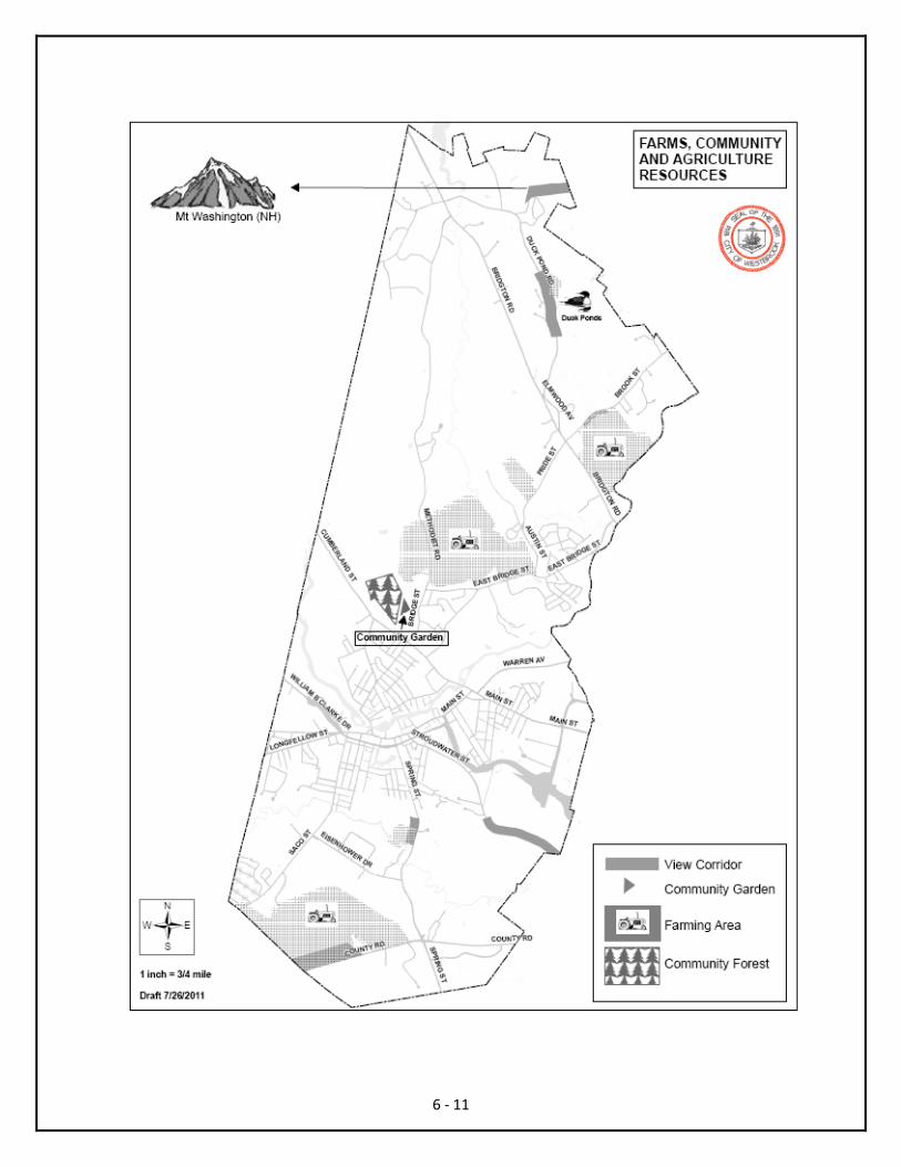
6 ‐ 11

CHAPTER 7: PUBLIC FACILITIES AND SERVICES
7 ‐ 1
ANALYSIS
During the planning period, the City of Westbrook will need to expand its services in the areas of adult education and social services. Westbrook is expanding and becoming more multicultural with more languages spoken in our community and school system than ever before. Westbrook is already providing a broad range of services to meet the needs of our changing population but must expand these services to ensure that the community as a whole thrives. Municipal offices, libraries and cemeteries will accommodate projected population growth during the planning period. There are no planned school construction or expansion projects anticipated in the planning period and the emergency response system is adequate too meet local needs. Investments in facility improvements often are directed to growth areas and this practice will continue.
Community Partnerships.
• Local. The municipal and school functions of Westbrook share a common finance and human resource function. By not having two separate departments, Westbrook reduces costs and redundancies and streamlines services.
• Regional. These efforts reduce costs and/or improve services.
o Assessing. Westbrook partners with South Portland to perform the assessing function.
o Community Services. Westbrook partners with nearby communities to provide transportation to local and regional services and events. In additional, Westbrook funds regional programs that administer local health services.
o Economic and Community Development. Westbrook is a member of the Greater Portland Economic Development Collaborative which takes a regional approach to business retention and attraction.
o Engineering. Westbrook shares a wastewater treatment plant with Gorham and Windham. Westbrook participates in a regional stormwater working group with communities within the Casco and Saco Bays for compliance with the National Pollutant Discharge Elimination System (an EPA permit for construction activity that disturbs one or more acres). Westbrook participates in the Long Creek Watershed Management District which is a regional partnership mandated by the EPA in order to maintain and improve the watershed. Westbrook partners with Gorham, Windham and the Portland Water District to provide wastewater treatment.
o Libraries. Westbrook participates in MINERVA, a statewide consortium of libraries which makes the holdings of all participating libraries available to patrons of those libraries. Westbrook participates in a statewide delivery service for books on loan from libraries participating in MINERVA. Walker Library participates in the Maine Schools and Libraries Network. Through this network, computer and internet access are provided free of charge to the public at the library.
o Public Safety. Westbrook participates in mutual aid agreements with neighboring communities which allow for the sharing of personnel and equipment in instances of major events or critical incidents. Westbrook also collaborates with area agencies in order to provide quality, reduced cost training and equipment acquisition.
STATE GOAL: To plan for, finance and develop an efficient system of public facilities and services to accommodate anticipated growth and economic development.

o Schools. Westbrook participates in the Sebago Alliance, which includes Windham, Raymond, Gorham and Scarborough with the mission of collaborating on educational programs, services and business operations. The Westbrook Regional Vocational Center is housed in Westbrook and is utilized and funded as part of a collaboration with nearby communities. Westbrook participates in the New England Association of Schools and Colleges (NEASC) which is a membership and accreditation agency for secondary schools in New England. Westbrook High School meets the accreditation standards of NEASC. Through the state’s Healthy Maine Partnership Program, the People’s Regional Opportunity Program’s (PROP) Community Promotion Health Coalition, a regional coalition, funds a School Health Coordinator position within the Westbrook school system. This position creates and manages programs that promote healthy living, which supports learning in our schools and community.
Condition of Community Infrastructure.
o Public Sewer. Westbrook is close to capacity for treatment of public wastewater. In conjunction with the Portland Water District, Westbrook has performed small projects to increase capacity of the system but we are beginning to experience the need for a second treatment plant. Additionally, Windham is moving forward with plans to serve North Windham, which will further the need for additional treatment and capacity in the area. Most businesses and homes in Westbrook are located on public sewer. Those businesses and homes with private septic systems must comply with state and federal requirements. Westbrook accepts disposal of septic waste at the treatment plant on Park Road, except in the summer, when it is accepted at the Portland Water District facility on Marginal Way in Portland.
o Public Water. The entire community is served or has the opportunity to be served by public water, which is provided by the Portland Water District.
o Solid Waste Management. Westbrook offers solid waste pick up for residential homes. The program is meeting current needs and will meet local needs during the planning period. The curbside collection program includes single stream recycling as well as annual collection of hazardous waste, universal waste and fall yard debris. Westbrook should maintain existing programs and expand recycling options.
o Street Tree Program. The Westbrook Public Services Department is responsible for the maintenance of all street trees in the city right‐of‐way and often outsources tree maintenance and planting. Westbrook has been designated as a “tree city” in the Tree City USA program. Westbrook has a designated City Arborist as part of the Public Services Department.
7 ‐ 2
o Stormwater Management System. Without adequate funding for proper maintenance and improvements, future development will further strain a system that is inadequately maintained at present. Resources should also be devoted to creating and maintaining a database of existing facilities.

7 ‐ 3

EXISTING SYSTEMS
Westbrook owns and manages its municipal and school functions. The largest non‐local owner/manager of a city function is the Portland Water District which has been further described in this and other chapters. Several buildings and community facilities currently need updating and will need to be addressed during the planning period. These include the Public Services building on Saco Street, school buildings and the Fraser field complex on Main Street. Details and priorities for improvements are outlined in the chapter covering the proposed capital improvement program. What follows is an overview of functions of the municipal and school operations as requested by the Maine State Planning Office.
o Education – The school function in Westbrook is administered by the Westbrook School Department. There is adequate capacity in the system to meet the anticipated demand during the planning period. Enrollment has declined slowly over the past planning period, despite an increase in the total population. This moderate decline is likely to continue. What follows is information on school enrollment as of January 2012:
o Westbrook High School – 695
o Westbrook Middle School – 564
o Saccarappa School – 257
o Prides Corner School* – 322
o Congin School – 331
o Canal School ‐ 222
* Prides Corner School was closed at the end of the school year and the schools were reorganized. The three remaining elementary schools will take grades K‐4, the Westbrook Middle School will take grades 5‐8 and the Westbrook High School will take grades 9‐12.
o Health Care, Housing and Social Services – There are four primary health care facilities located in Westbrook and Westbrook is located in convenient proximity to major hospitals and a wide variety of health care services. Mercy Hospital and Maine Medical Center have facilities in Westbrook. One facility provides urgent care and primary care services on Main Street while the other provides treatment services on Park Road. Maine Centers for Healthcare offers a wide range of health care services from their facility on Chabot Street, near Interstate 95, Exit 48. Springbrook Nursing Home provides nursing care at their facility on Spring Street. Spring Harbor Hospital provides a regional inpatient mental health facility on Andover Road. There are also a number of smaller facilities offering specialized and general care in Westbrook. Westbrook manages the local distribution of Housing Choice Vouchers for Maine State Housing. Housing Choice Vouchers allow for moderate and low‐income families to choose their home with the Housing Choice Vouchers meeting the difference between the market rate rent for a housing unit and what the family can afford based on their income. The Westbrook Community Center offers a variety of social services to meet the needs of our growing and diverse population. Despite the number and variety of providers listed here, the community and the region should examine whether or not existing services and programs are adequate to meet the changing needs of our population.
7 ‐ 4
o Power and Communications ‐ Westbrook currently has outstanding assets in both telecommunications and energy infrastructure. The city should explore ways to expand its position as a provider of major utilities and explore opportunities to integrate cogeneration for heat and,

perhaps someday power, in future developments particularly by taking advantage of the potential for both in some of Westbrook’s largest businesses. Three phase power, redundant internet and cable television are widely available in the community.
o Public Safety
o Emergency Response System. The police department operates from the Public Safety Building located at 570 Main Street. Police personnel are equipped in a manner consistent with a contemporary law enforcement department. The fire and emergency/rescue department is located at 570 Main Street in the Public Safety Building and at Station 3 on Bridgton Road (Route 302). The communications center, for dispatch of calls from Westbrook, Falmouth and Yarmouth, is also located in the Public Safety Building. Both the police and fire and emergency rescue departments are equipped in a manner consistent with contemporary needs and large equipment needs are met and planned for.
o The police department received approximately 35,395 calls for service in 2010. The average response time for the first six months of 2011 was 5.2 minutes while the average response time for in progress calls was 2.7 minutes.
o The fire rescue department received approximately 4,400 calls for service in 2010. The average response time for the first six months of 2011 was 4.7 minutes while the average response time for active reported fires was 1.4 minutes.
o Maine is comprised of District Coordinating Councils for Public Health. The District Coordinating Council is a representative district‐wide (generally county wide) body of public health stakeholders, such as schools, hospitals, home healthcare providers and public health officials, working toward collaborative public health planning and coordination to assure effectiveness and efficiencies in the public health system. Westbrook has a Local Health Officer who is a member of the Cumberland District Public Health Council. Westbrook is part of the Healthy Region Lakes District which provides a link between the department’s Maine Center for Disease Control and Prevention and every Municipality.
o Solid Waste
o The recycling rate has improved from approximately 16% to 43% since its inception in 2008. The prior program required that residents transport their household recycling to metal collection bins in key locations throughout the city.
o The municipal solid waste (MSW) collection levels have been cut in half since 2007 (from 7,691 tons to 3,855 tons).The curbside recycling program is less than five years old.
7 ‐ 5
o Stormwater Management – Westbrook has several points of combined sewer overflow (CSO). Combined sewer systems are common to established cities and are designed to collect rainwater runoff, domestic sewage and industrial wastewater in the same pipe. Most of the time, combined sewer systems transport all of their wastewater to a sewage treatment plant, where it is treated and then discharged into a water body. During periods of heavy rainfall or snowfall, however, the wastewater volume can exceed the capacity of the system or treatment plant. For this reason, combined sewer systems are designed to overflow and occasionally discharge excess wastewater directly to nearby streams, rivers or other water bodies. These overflows are called CSOs. Westbrook is currently working to eliminate CSOs and replace aging infrastructure via CSO master plan. The master plan is in conformance with state and federal policies and goals for eliminating CSOs.

o Staffing and Facilities for Municipal Functions.
o Municipal Administrative. There are approximately 25 positions performing the municipal administrative function which is located on York Street. Several of these positions are shared with the School Department. These positions cover the Mayor’s Office, City Clerks Office, and Departments of Finance, Human Resources, Assessing, Engineering, Community and Economic Development and Planning.
o Enforcement. There is one full time Code Enforcement Officer and one part time Fire Code Inspector dedicated to code enforcement in Westbrook.
o Public Services. There are approximately 28 positions performing the public services function and they housed out of the public services building on Spring Street. This department takes advantage of economies and efficiencies of scale by outsourcing certain seasonal functions.
o The Fred C. Wescott building, commonly known as the Westbrook Community Center, is a multi‐purpose center serving the residents of Westbrook by providing opportunities for social, recreational and other basic needs to be met. Through collaboration, partnering and working together, the center offers an array of community services that address the needs of Westbrook residents and help them to find and access resources that enrich their lives. The center offers a pool, gym, thrift store, food pantry and multiple gathering spaces and activities. There are approximately 8 full time positions operating out of the center, with approximately 70 seasonal/part time positions operating at the various recreational facilities throughout the city and that are managed out of the center.
o Walker Memorial Library. There are approximately 11 positions performing the public library services function at the Walker Memorial Library which is located along Main Street. The library building was built in 1894 and has since been expanded and the original building has been restored over the past several years. Walker Memorial Library is a cultural center of the community that provides engaging programs featuring authors, artists and educators in order to expand the horizons of library users and showcase regional talent and opportunities. The library is continually expanding its technology base by offering direct access to the internet and opportunities for users to access books and other resources digitally.
Strategies for Implementation Implementation of these strategies will be coordinated by staff on an on‐going basis and as funding allows, based on a public participation process to establish funding priorities.
• Westbrook will continue to efficiently meet identified public facility and service needs. Public‐private partnerships and regional delivery of local services will be explored to meet these needs. This includes working with businesses such as Sappi Fine Paper and Calpine Energy to make use of their excess heat generated by their facilities to provide heat to nearby businesses and neighborhoods.
• Westbrook does not anticipate public‐only funding for the extension of public sewer and/or other public facilities and services outside of growth areas but may connect existing growth areas where it is deemed logical from a long‐range planning perspective.
7 ‐ 6
CHAPTER 8: RECREATION
EXISTING SYSTEM Presently in Westbrook, there are 3 public parks and playgrounds, 4 playgrounds associated with schools, two public swimming pools – one indoor and one outdoor, 6 public locations with multi‐use and specific use fields. All schools have multi‐use fields. Westbrook has three recreational skating rinks, a boat launch and a skateboard park. Also, the Westbrook Riverwalk provides public access to the Presumpscot River in the downtown. Within the next two years, a large multi‐purpose field will be developed, in coordination with a private landowner, in the northern part of the city, near Methodist Road, which will enable the city to utilize even more field space for its many athletic teams and recreational needs. The existing recreational resources, facilities and programs in this community will continue to accommodate projected growth and changes as we continually evaluate need and bring forth programs for the population. There is a good working knowledge of what is desired and needed for programs. In January 2009, Westbrook expanded its recreation program to a community center model and opened a multi‐tenanted and multi‐use facility at the former Wescott Junior High School building. At present, the community center offers an array of programs to all citizens of any age and skill level. Through the community center, swimming lessons, fitness and nutrition classes and programming such as after care and summer camp for children provide a much needed service for residents. These programs are continually full and utilized. Westbrook has a rich history of offering many co‐ed community programs such as little league, Tuffy football and soccer that are affordable and accessible to all Westbrook residents. In addition, independent groups, such as the Seals swim team, support the facility through renting the pool, but also offering an opportunity for residents to participate in programs such as this. With regard to open space, the most important component of contiguous “active” open space that is not publicly owned in Westbrook is the local off‐road trails. The Westbrook Trail Blazes (http://www.westbrooktrailblazes.com), our local snowmobile club and also a member of the Maine Snowmobile Association, has obtained landowner permission to use an off‐road system of trails for winter sports, including snowmobiling. This provides the public with access to an extensive network of off‐road trails for winter activities. The City of Westbrook and the Westbrook Recreation Conservation Commission have partnered with the snowmobile club to improve the trails. The snow mobile club has made the most significant effort to date to provide public access to popular off‐road trails. With regard to public access to significant water bodies, the City of Westbrook owns land along each significant water body in Westbrook, but there is no welcoming place for the public to access Highland Lake or the Stroudwater River in Westbrook. There is public access to Highland Lake approximately ½ mile to the north, in Falmouth. There is adequate public access available at points along the Presumpscot River, Beaver Pond and Mill Brook.
8 ‐ 1
STATE GOAL: To promote and protect the availability of outdoor recreation opportunities for all Maine citizens, including access to surface waters.
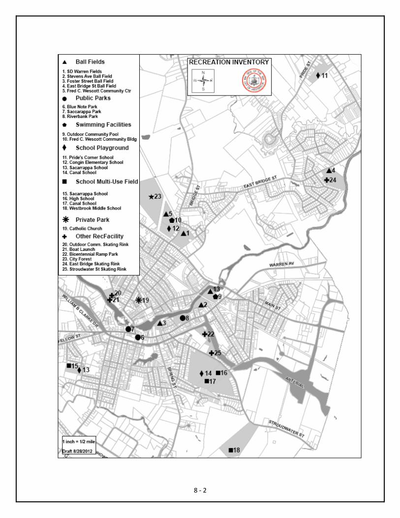
8 ‐ 2

One of the most important things affecting a landowner’s decision to allow public access to private property is respect. According to a 2008 Maine State Planning Office document prepared for the Governor’s Council on Maine’s Quality of Place, seventy‐eight percent of a sample of Maine landowners agreed that feeling respected by members of the public seeking access to private property for recreation is an important factor in allowing such access. This sentiment underscores the important role of landowner relations initiatives and educating users on appropriate behavior on private property. (http://www.maine.gov/spo/specialprojects/qualityofplace/documents/publicaccesstomainesprivatelands.pdf) There are several important local partners that support the expansion of open space and recreation opportunities in Westbrook. • Recreation Conservation Commission. The Recreation Conservation Commission is appointed by the
City Council to oversee management of the Westbrook City Forest and funds raised by or land gained with new residential subdivisions and other applicable new development.
• Westbrook Environmental Improvement Corporation (WEIC). WEIC was formed for the purpose of retaining and protecting of natural, scenic, or open space values of real property, protecting natural resources, and maintaining or enhancing air or water quality while fostering business enterprises within the city. WEIC is a non‐profit and is an established land trust. WEIC is funded largely through grants and TIF revenues, and has been a useful tool for the preservation of open space in the city. WEIC is the easement holder of approximately 30 acres preserved as open space behind the Westbrook Middle School. WEIC also played an important role in financing the Westbrook Riverwalk.
• Cornelia Warren Community Association – Cornelia Warren, the daughter of of mill owner S.D. Warren, was a prominent philanthropist in Westbrook. In life, Cornelia Warren funded many recreational and education endeavors in Westbrook. In her will, she included an endowment for the city to be used toward educational and recreational resources for people of the city. The endowment is administered by the Cornelia Warren Community Association. Projects include construction and continued investment in the Cornelia Warren Pool; donation of park infrastructure such as trash bins, park benches and the Veteran’s Memorial Bricks in Riverbank Park; support for the Mission Possible Teen Center; renovation funds for the Fred C. Wescott Building; and holiday banners for the ornamental light poles along the recently rebuilt William Clarke Drive.
• Westbrook Trail Blazes – This local partner was described earlier in this chapter. REGIONAL PARTNERSHIPS • Portland Trails ‐ Create and maintain a 50‐mile network of trails in Greater Portland. Engage the
participation of neighborhoods, schools, and the business community in trail use and land stewardship. Make Greater Portland a model for people‐powered recreation and transportation. Non‐motorized. Manage their trails, often working with local partners.
• Mountain Division Trail ‐ The MDT, when completed, will connect Portland with the town of Fryeburg on the New Hampshire border. This is a rail with trail, with the rail active in some places. Non‐motorized. Manage their trails, often working with local partners.
8 ‐ 3
• Presumpscot Regional Land Trust ‐ The Presumpscot Regional Land Trust (PRLT) is a conservation stewardship organization founded in 1986 whose mission is to conserve and protect natural lands and historic landscapes for posterity in the Presumpscot River watershed and western shore area of Sebago Lake. In fulfillment of its mission, PRLT uses easements or ownership to acquire significant

interests in outstanding lands that preserve the natural character of the region, most particularly those that: preserve critical wildlife habitat; afford public access for recreational opportunities; are located near water (including rivers, lakes, ponds, wetlands); are large and contiguous blocks; are adjacent to existing conservation lands; are important for agricultural uses; and possess strong visual and scenic qualities. At the forefront of land protection efforts along much of the northern portions of the Presumpscot River, the PRLT is the only land trust in Maine whose land protection efforts focus on the Presumpscot River watershed and western shore area of Sebago Lake. Non‐motorized. Manage their trails, often working with local partners.
• Sebago to the Sea ‐ The Sebago to the Sea Trail vision is to establish a contiguous trail from Sebago Lake to Casco Bay connecting Standish, Windham, Gorham, Westbrook, Portland and Falmouth. Members of the Sebago to the Sea Coalition are working with partners within each corresponding town to acquire rights of way. Connecting six towns, this trail will provide residents and visitors with wonderful biking, hiking, walking and commuting opportunities. Non‐motorized. Working with local partners and other trail organizations to manage trails.
RECREATION PLANNING LOCALLY The mission of the City of Westbrook is to: • Provide the community with a quality of life that is enhanced by recreation opportunities,
parks and open space. • Provide services and amenities for the widest range of users possible. • Recognize the benefits of a multifaceted approach, including: active and passive
opportunities; indoor and outdoor recreation; constructed as well as natural amenities. • Work with landowners using the principle of voluntary landowner participation. • Recognize the service demand created when land is developed for residential and
commercial uses. • Plan for future needs while budgeting for the maintenance and operation of existing and
proposed recreation, park and open space amenities. • Instill an appreciation for public and private facilities through stewardship.
8 ‐ 4
• Identify opportunities to enhance services provided by the City of Westbrook through partnering with public and private organizations.
The recreation plan for the City of Westbrook is simple, brief and intended to be flexible, so that as Westbrook changes over time then the plan can respond and absorb those changes. Priority should be placed on maximizing use of existing facilities before putting resources into new facilities. The City of Westbrook will establish a walkable network of neighborhood parks and open spaces throughout the City, provide multi‐purpose fields in the northern part of the City and establish a greenway corridor which connects these parks, open spaces and recreation facilities. Strategies for Implementation Implementation of these strategies will be coordinated by staff on an on‐going basis and, where necessary, as funding allows, based on a public participation process to establish funding priorities.

• Westbrook will continue to maintain existing recreational facilities as necessary to meet current and future needs.
• Westbrook will continue to preserve open space for recreational use as appropriate. • Westbrook will seek to achieve or continue to maintain at least one point of public access to major
water bodies for boating, fishing, and swimming, and work with nearby property owners to address concerns.
• Westbrook will continue to work with local and regional partners, including landowners, to extend and maintain a network of trails for motorized and non‐motorized uses, where appropriate.
• Westbrook will continue to work with local and regional land trusts or other conservation organizations to pursue opportunities to protect important open space or recreational land.
• Westbrook will continue to promote respect for private property. • Westbrook will continue to provide educational materials regarding the incentives, benefits and
protections for landowners allowing public recreational access on their property. At a minimum this will include information on Maine’s landowner liability law regarding recreational or harvesting use, Title 14, M.R.S.A. Section 159‐A.
8 ‐ 5
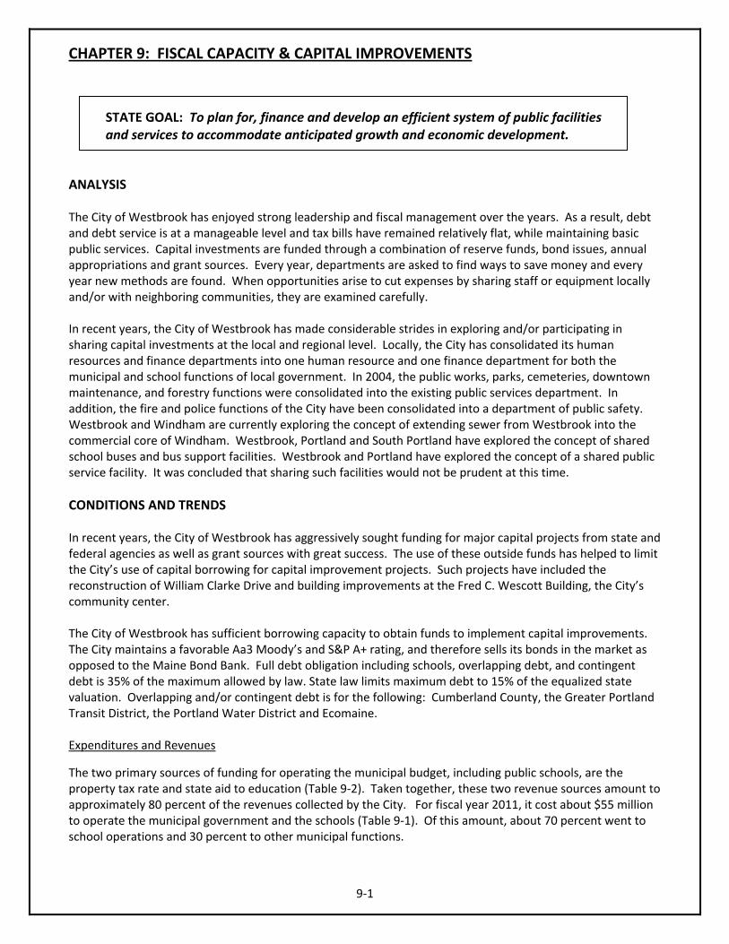
CHAPTER 9: FISCAL CAPACITY & CAPITAL IMPROVEMENTS
ANALYSIS The City of Westbrook has enjoyed strong leadership and fiscal management over the years. As a result, debt and debt service is at a manageable level and tax bills have remained relatively flat, while maintaining basic public services. Capital investments are funded through a combination of reserve funds, bond issues, annual appropriations and grant sources. Every year, departments are asked to find ways to save money and every year new methods are found. When opportunities arise to cut expenses by sharing staff or equipment locally and/or with neighboring communities, they are examined carefully. In recent years, the City of Westbrook has made considerable strides in exploring and/or participating in sharing capital investments at the local and regional level. Locally, the City has consolidated its human resources and finance departments into one human resource and one finance department for both the municipal and school functions of local government. In 2004, the public works, parks, cemeteries, downtown maintenance, and forestry functions were consolidated into the existing public services department. In addition, the fire and police functions of the City have been consolidated into a department of public safety. Westbrook and Windham are currently exploring the concept of extending sewer from Westbrook into the commercial core of Windham. Westbrook, Portland and South Portland have explored the concept of shared school buses and bus support facilities. Westbrook and Portland have explored the concept of a shared public service facility. It was concluded that sharing such facilities would not be prudent at this time. CONDITIONS AND TRENDS In recent years, the City of Westbrook has aggressively sought funding for major capital projects from state and federal agencies as well as grant sources with great success. The use of these outside funds has helped to limit the City’s use of capital borrowing for capital improvement projects. Such projects have included the reconstruction of William Clarke Drive and building improvements at the Fred C. Wescott Building, the City’s community center. The City of Westbrook has sufficient borrowing capacity to obtain funds to implement capital improvements. The City maintains a favorable Aa3 Moody’s and S&P A+ rating, and therefore sells its bonds in the market as opposed to the Maine Bond Bank. Full debt obligation including schools, overlapping debt, and contingent debt is 35% of the maximum allowed by law. State law limits maximum debt to 15% of the equalized state valuation. Overlapping and/or contingent debt is for the following: Cumberland County, the Greater Portland Transit District, the Portland Water District and Ecomaine. Expenditures and Revenues
The two primary sources of funding for operating the municipal budget, including public schools, are the property tax rate and state aid to education (Table 9‐2). Taken together, these two revenue sources amount to approximately 80 percent of the revenues collected by the City. For fiscal year 2011, it cost about $55 million to operate the municipal government and the schools (Table 9‐1). Of this amount, about 70 percent went to school operations and 30 percent to other municipal functions.
9‐1
STATE GOAL: To plan for, finance and develop an efficient system of public facilities and services to accommodate anticipated growth and economic development.
Table 9‐1: City of Westbrook Expenditures By Category
FY2007‐FY2011
Year 2007 2008 2009 2010 2011 General Government $4,775,970 $5,312,457 $5,416,222 $5,348,050 $5,536,196 Public Safety $4,849,158 $5,066,885 $5,260,025 $5,422,109 $5,834,367 Public Works $3,606,884 $3,790,673 $3,937,920 $3,979,412 $3,930,093 Human Services $355,961 $368,870 $403,509 $515,812 $498,215 Recreation $892,532 $1,013,126 $1,111,810 $1,788,118 $1,892,082 Transfers $3,952,582 $2,710,224 $2,779,643 ‐ ‐ Economic Development ‐ ‐ ‐ $122,622 $117,087 Other Uses ‐ ‐ ‐ $1,767,721 $1,470,473 Debt Service $2,950,699 $2,939,007 $2,832,761 $3,251,496 $3,041,621 Capital Projects $50,000 $50,000 ‐ ‐ ‐ Total City $21,433,786 $21,251,242 $21,741,890 $22,195,340 $22,320,134 County Tax $886,479 $918,685 $973,345 $976,350 $998,695 Education $27,880,584 $29,281,123 $30,987,183 $33,015,265 $33,021,812 Total Expenditures $50,200,849 $51,451,050 $53,702,418 $56,186,955 $56,340,641
9‐2
Table 9‐2: City of Westbrook Revenues By Category
FY2007‐FY2011
Year 2007 2008 2009 2010 2011 Taxes * $32,002,927 $32,073,947 $32,331,259 $30,934,702 $30,691,747 Licenses & Permits ** $372,050 $382,650 $475,150 $2,525,000 $2,622,500 Intergovernmental (State) ***
Schools:$13,033,809 Other: $969,285 Total: $14,003,094
Schools:$13,671,546 Other: $672,836 Total:$14,344,382
Schools:$15,346,785 Other:$444,920 Total:$15,791,705
Schools:$2,927,192 Other: $54,000 Total:$2,981,192
Schools:$2,697,812 Other:$253,823 Total:$2,951,635
Charges for Services $1,705,148 $721,900 $740,900 $928,465 $898,450 Investment Income $60,000 $100,000 $200,000 $113,000 $113,000 Other Revenues ** $477,624 $2,359,105 $2,799,767 ‐ ‐ Reserve Fund **** $307,956 $60,000 $40,000 $98,038 $80,790 Transfers (Schools) *** $1,272,050 $1,409,066 $1,323,637 $18,606,558 $18,982,520 Total Revenues $50,200,849 $51,451,050 $53,702,418 $56,186,955 $56,340,642 Notes: * Decreasing tax revenues and increased spending on the School Department, as depicted in Table 9‐1, reflects an increased availability of federal funds for education. **Changes in Other Revenues and Licenses and Permits reflects the proper reclassification of registrations from Other Revenues to Licenses and Permits. ***Changes in Intergovernmental and Transfers reflects the reclassification of School Department funding per government accounting rules (GASB 14). ****A decrease in the amount of Reserve Funds indicates more conservative budgeting.
Property Valuation
The City of Westbrook makes great effort to keep the tax rate low while maintaining basic public services. The tax rate is established by estimating the cost to provide services compared to the value of all property available for taxation. The City conducted a citywide revaluation in 2007, this is reflected in the lowered tax rate and increased assessed value ratio that took effect in 2008 (Table 9‐3). The increase in value between 2006 and 2010 is reflective of increased real property values. It is clear that the local property market peaked in 2007 and 2008 and has experienced a modest decrease in value, consistent with an overall nationwide downturn in property values. Maine has not faired as poorly as some regions and states that experienced an unprecedented spike in property values in the early and mid‐2000s and so Maine has had a shorter fall to get to a new equilibrium in property values. At this time, however, it is uncertain whether the real estate market has stabilized. Meanwhile, the City must continue to provide a basic level of public services, such as snow plowing, local road maintenance, schools and trash pick‐up.
9‐3

Table 9‐3: MUNICIPAL VALUATION
Year Value Tax Rate (per $1,000 of assessed value)
Assessed Value Ratio
2010 $1,849,708,000 $16.70 100%
2009 $1,843,891,100 $15.43 100%
2008 $1,915,700,300 $15.43 100%
2007 $1,899,012,200 $23.87 60%
2006 $1,233,218,400 $23.10 70%
Table 9‐4: STATE VALUATION
Year Value
2010 $1,880,300,000
2009 $1,844,650,000
2008 $1,871,500,000
2007 $1,723,650,000
2006 $1,577,450,000
Note: The state valuation is a mass appraisal estimate of a municipality (the City as a whole) based on 100% of the current market value which is fixed by the State Tax Assessor each year, so that the levy of county taxes will be equalized between the various municipalities, and so that grants of state money made on the basis of total taxable valuation will be fairly distributed. Local assessors provide an abstract of local valuations annually, which provides a comparison for the state. The state valuation lags municipal assessments by nearly two years, so the 2010 state valuation corresponds to the information provided by the City in 2008.
Strategies for Implementation. Implementation of these strategies will be coordinated by staff on an on‐going basis and as funding allows.
• The City of Westbrook has a capital improvement plan that summarizes capital investment needs, approximates funds needed for the investments and provides a general timeframe for implementation of the investments.
• Westbrook will expand its efforts to engage the public in defining priorities for capital investments.
• Westbrook will continue to finance facilities and services in a cost effective manner and will explore public‐private partnerships and available grant funding in order to maximize the public investment.
• Westbrook will comply with LD1 spending limitations.
9‐4
• Westbrook will continue to explore opportunities to work with neighboring communities to plan for and finance shared or adjacent capital investments to increase cost savings and efficiencies.

CAPITAL INVESTMENT PLAN
As part of the public process to generate the City of Westbrook Comprehensive Plan, public input was gathered, by way of visioning meetings and a questionnaire, on what should be the priorities for local capital improvements. The capital improvement categories considered and their ranking, by number of votes, were as follows:
• Pedestrian improvements in the downtown (51 votes). This will serve to reduce local vehicle trips to and within the downtown, will enable increased use of the public transportation system and will serve as an attraction for economic development.
• Municipal buildings (ex. public services facility, Fred C. Wescott Building (community center), Walker Memorial Library) (38 votes). The public services facility on Saco Street will be rebuilt during the planning period, the Fred C. Wescott Building will be maximized as a space for community services and the Walker Library will have received interior and exterior maintenance that will preserve this public asset in the downtown for many years to come.
• Road and bridge improvements (31 votes). These improvements will maximize the efficiency of local, state and state‐aid roadways.
• Extending sewer to more areas of the City (13 votes). If an extension were to take place, then it should be located in an existing developed area.
There was consistent and majority support for improvements to the pedestrian experience in the downtown. There was also considerable support for responsible improvements to public buildings, followed by road and bridge improvements.
9‐5
Priority improvements that are growth‐related include a focus on reinvestment in elementary schools and maintenance and expansion of wastewater and stormwater facilities. There are many needs for maintenance of basic infrastructure in Westbrook. The existing public services building and facilities, located on Saco Street, will be rebuilt on their existing site in order to provide a more efficient and safe working environment and facilities that are adequate to ensure a basic level of preservation of machines and materials necessary to perform the public services function for the City of Westbrook. Pedestrian improvements in the downtown will be performed as will road and bridge improvements. Westbrook will continue to fund capital improvements using a combination of reserve funds, bond issues, annual appropriations and grant funding.

CHAPTER 10: FUTURE LAND USE PLAN
SUMMARY Thus far in the Comprehensive Plan, the demographic, economic, historical, infrastructure, recreational, environmental and fiscal characteristics have been inventoried and analyzed. Recommendations for the future management of the City’s various resources have been formulated. The Future Land Use Plan is intended to guide future land use and allocation of public services, such as sewer, in the City. The land use designations within growth areas are intended to make land development efficient and attractive. The land use recommendations are consistent with the overall vision for the City and the visions for the four quadrants of the City, as created and adopted with this Comprehensive Plan. ANALYSIS For the most part, the municipal zoning strategy has worked effectively. The residential zones have been formulated to reinforce the patterns of the older neighborhoods that existed long before zoning mechanisms came to Maine. Non‐residential zoning has focused on expanding the tax base and has been fulfilling that mission. Few modifications are proposed to existing zoning as the existing zoning ordinance was adopted in 2004, as a result of recommendations of the 2000 Comprehensive Plan. While minor modifications have been made to the zoning ordinance since that time, in order to further clarify the objectives of the zoning provisions, the changes proposed for consideration herein are intended to be forward thinking should be driven by market conditions that may not yet be in place. Implementation of zoning changes will be part of a public process following adoption of this Comprehensive Plan. Implementation will be coordinated by staff.
10 ‐ 1
STATE GOAL: To encourage orderly growth and development in appropriate areas of each community, while protecting the state's rural character, making efficient use of public services, and preventing development sprawl.

GROWTH & RURAL AREAS The State of Maine requires that municipalities designate areas where future development should be encouraged. These districts are to be classified as “growth areas”. State criteria for designating suitable growth areas include:
• Lands in proximity to existing municipal services, infrastructure, schools, and major transportation networks;
• Areas in which developable lands are readily available to accommodate future growth; and • Areas devoid of critical natural resources and visual/cultural resources that should be preserved.
Based on past and planned growth in Westbrook, all but those areas planned and zoned Rural, or within the Shoreland Zone, are designated as Growth Areas on the Proposed Growth Areas and Rural Areas map. The areas planned and zoned Rural are designated as such. The remaining areas are in the Shoreland Zone. The City’s three Shoreland Zones have been found consistent with state requirements and provide varying levels of regulation based on the type of water body and existing level of development at the time when shoreland zoning was first promulgated. Growth Areas are subdivided into Residential, Industrial and Mixed Use Districts and are intended to accommodate those land uses. Rural areas are intended to remain that way, with low‐density residential housing being the primary land use. A description of the location and intent of each of the designated Growth Areas and Rural Areas is further described below.
10‐2
It is understood that in each of the growth and rural areas, municipal facilities and public utilities are permitted uses. Their development will still require site plan review on a case‐by‐case basis, if triggered by the amount of site improvements, with the scale of the facilities managed in order to reduce conflict with their surroundings.

10‐3

10‐4

RESIDENTIAL GROWTH AREAS Residential Growth Area 1 RGA‐1 encompasses the established residential areas within and surrounding the urban core of the City. The principle focus of this growth area is to infill the remaining vacant residential parcels that have immediate access to existing public services and pose little expense to the City. The areas designated as RGA‐1 include the areas designated as such in the 2000 Westbrook Comprehensive Plan and currently zoned RGA‐1. Permitted uses should continue to include single‐family, two‐family dwellings and multiple‐family dwellings by special exception approval. Low intensity commercial uses should continue to be allowed as reflected in the zoning ordinance. Residential density should continue to be allowed at a rate of one unit per 7,500 square feet for new lots and one unit per 5,000 square feet for existing lots and condominium units. Since adoption of the 2004 zoning ordinance, the City has made modifications to the provisions for existing lots in order to enable their development, but to ensure their consistency with surrounding developed lots. These provisions are important to the success of infill development, which has the least impact on public services, such as schools and public safety. See the zoning ordinance for complete space and bulk provisions. Residential Growth Area 2 RGA‐2 is intended to develop suburban style neighborhoods in areas that can easily be served by municipal infrastructure. This area is a mixture of older subdivisions and vacant land that would best be served by interconnected road systems. The lack of connectivity is reflected on the Future Land Use Map and the recommendation for connectivity is a carry over from the 2000 Comprehensive Plan. Street connectivity is preferred as it enables faster response times for emergency services and facilitates more efficient delivery of public services, such as snow plowing. This enables a more optimal use of tax dollars for these services. New development is encouraged to bring sewer to sites, through the use of density incentives. For the most part, the areas designated as RGA‐2 include areas designated as such in the 2000 Westbrook Comprehensive Plan and currently zoned RGA‐2. Permitted uses should continue to include single‐family, two‐family dwellings and multiple‐family dwellings by special exception approval. Low intensity commercial uses should continue to be allowed as reflected in the zoning ordinance. Residential density should continue to be limited to one unit per 10,000 square feet for lots on public sewer and one unit per 20,000 – 40,000 square feet for lots not on public sewer, with final density based on a hydrological impact study which shows that the soils can accommodate the proposed density, and the provision of an appropriately sized communal septic system. See the zoning ordinance for complete space and bulk provisions. Areas Designated RGA‐2 (See Future Land Use Map):
• East Bridge Street; • Austin Street; • Brook Street; and • Saco Street – west side, south of Stroudwater River.
Residential Growth Area 3
10‐5
RGA‐3 encompasses lands east of the Bridgton Road corridor (see the Future Land Use Map). This includes land currently zoned RGA‐3. This is the smallest residential growth area in Westbrook and is intended to create a similar growth pattern to the Falmouth border. The RGA‐3 designation recognizes that public sewer is not likely to be extended in the near term and that historical and recent development trends show a preference for lower density and preservation of open space in this area. While the area is rural in character, there is not an abundance of farm lands. The cluster density provisions of the zoning ordinance are designed to preserve open space and maintain the rural character along Duck Pond Road. Permitted uses should

continue to include single‐family and two‐family dwellings. Low intensity commercial uses should continue to be allowed as reflected in the zoning ordinance. Residential density should continue to be limited to one unit per 60,000 square feet for single traditional lots and one unit per 20,000 square feet for subdivisions with cluster designs. Setbacks are also reduced for cluster subdivisions. See the zoning ordinance for complete space, bulk and buffer provisions. COMMERCIAL GROWTH AREAS Westbrook’s commercial growth areas include three mixed use districts and two industrial districts. Mixed use development allows commercial and residential development to exist on the same parcel, either adjacent to each other or in the same building. The best examples of mixed use development can be found in almost any New England village, where residential and commercial uses mingle. Westbrook’s historic downtown Main Street is a prime example of a successful mixed use district. This concept continues to be supported by the real estate market. It is our intent to promote the viability of our commercial areas, from both an economic development standpoint and a livability standpoint. In the mixed use districts, there should be a focus on physical form and function, rather than placing the primary focus on land use. Buildings and open spaces should contribute to the public realm instead of hiding from it behind large parking lots and other development infrastructure. The recommendations for implementation listed herein are intended to promote these concepts and any new zoning provisions adopted would be implemented with new development. We do not intend to create non‐conforming uses with this plan. Downtown Mixed Use District The Downtown Mixed Use District is intended to create a flexible atmosphere for the return of downtown to a prominent regional service center. This area should continue to be developed consistent with the site design and architectural character of historic downtown Westbrook. On‐site parking is not required for non‐residential uses in order to support the traditional downtown urban form and the constraints of the small lots that form the majority of the Main Street corridor. Development should be consistent with the Downtown Revitalization Plan, Downtown Parking Plan, Downtown Streetscape Plan and Riverfront Master Plan, as well as other planning efforts that promote these goals. The Downtown Mixed Use District reflects the area zoned City Center District and runs generally from Cumberland Mills to the Gorham town line and includes Bridge Street on the north side of the Presumpscot River (see the Future Land Use Map). A wide variety and intensity of residential uses should continue to be allowed, as well as commercial uses traditionally found in downtowns. See the zoning ordinance for complete space and bulk provisions Gateway Mixed Use District
10‐6
The Gateway Mixed Use District is intended to provide for a regional service center that takes advantage of major transportation linkages, with its close proximity to Exits 47 and 48 of the Maine Turnpike as well as its close proximity to downtown Portland via Main Street/Brighton Avenue. This area generally reflects the area zoned Gateway Commercial District and is currently developed with a mix of strip retail development, such as free standing fast food restaurants and retail, car lots, industry, office and extractive industry. The area extends from just south of the Warren Avenue corridor to the Westbrook Arterial, along Larrabee Road. The current zoning provisions for new development promote a form and standard of development in keeping with a prominent regional service center. Many of the large lots, dominated by legal non‐conforming uses (car lots and extractive industry), are available for future development under the Gateway provisions. This area, the Main Street/Brighton Avenue corridor, was the subject of a land use study with the City of Portland that recommended enhanced treatment of the “gateway” areas of Westbrook and Portland. More can be done to

promote the gateway concept. A mix of uses promoting the regional service center concept, including multiple‐family dwellings, should continue to be allowed. Recommendations for implementation. Implementation of zoning changes will be part of a public process following adoption of this Comprehensive Plan. Implementation will be coordinated by staff.
• Revise the zoning ordinance to establish specific provisions for residential density for the multiple family dwelling use;
• Revise the zoning ordinance to establish that industrial uses, municipal facilities and telecommunications infrastructure should be located beyond the immediate Main Street corridor; and
• Revise the zoning ordinance to promote consolidated development on large lots. • Revise the zoning ordinance to establish a uniform building line on Main Street.
Corridor Mixed Use District The Corridor Mixed Use District is a new growth area designation that is intended to replace the Highway Commercial 1 and 2 land use designations of the 2000 Comprehensive Plan and, ultimately, the Prides Corner Smart Growth Area and Highway Services zoning districts of the zoning ordinance. The Corridor Mixed Use District includes the Bridgton Road (Route 302) corridor and the east and west sides of Spring Street, generally south of the County Road corridor to the South Portland city line (see Future Land Use Map). The visions for these areas remain consistent with those of the 2000 Comprehensive Plan and zoning ordinance – to promote high‐quality cohesive commercial and mixed‐use development on consolidated lots while reducing traffic congestion. The scale and intensity of development should respect the surrounding residential neighborhoods while being substantial enough to establish an identifiable and attractive neighborhood mixed‐use commercial corridor. This concept has been promoted through recent lot consolidation and a higher level of building design and architectural detail. Recommendations for implementation: The following recommendations are intended for short term implementation, with the update of the zoning ordinance as identified in this Comprehensive Plan update, would be implemented with new development, and are not dependent on access to public sewer.
• Revise the zoning ordinance to reduce the frequency of curb cuts. This new provision would apply to new construction. Less frequent curb cuts reduces traffic congestion. It also promotes site consolidation and, therefore, coordinated development.
• Revise the zoning ordinance to establish a uniform building line along Bridgton Road and Spring Street. • Revise the zoning ordinance to allow multi‐family residential dwellings.
The following recommendations are dependent on the provision of public sewer and other necessary infrastructure improvements, which should not be solely dependent on public funding.
• Revise the zoning ordinance to include a new Corridor Mixed Use District land use designation which will further establish the mixed‐use district concept. This district would establish space and bulk provisions. Increased density may be appropriate but building height should not exceed 4 stories.
• Rezone these areas to the Corridor Mixed Use District.
10‐7

Industrial District Industrial District primarily includes those areas currently zoned Industrial Park District, and Manufacturing District. There is a portion of the area currently zoned Residential Growth Area 1 that lies north of the Stroudwater River that was planned Industrial District with the 2000 Comprehensive Plan. That area is proposed to remain planned Industrial. The Industrial District is intended to continue the City’s long‐standing policy of developing industrial, manufacturing and other larger scale commercial uses in proximity to existing services, and major transportation routes adjacent to similar districts in Portland and South Portland. This area is almost completely built out and much of the remaining vacant areas south of County Road consist of environmentally sensitive forested wetlands. Density provisions in the Industrial District should continue to allow improvement of the majority of a lot in order to enable maximum use of properties zoned for industrial and manufacturing uses, which have the highest return on investment of tax dollars. Areas designated Industrial District (see Future Land Use Map):
• Generally, the area from Saco Street to the Portland city line, just north of the Stroudwater River to the South Portland city line, but not including Smiling Hill Farm; and
• The Warren Avenue corridor, including the Sappi property to the Portland city line. Industrial District II The Industrial District II is generally proposed on both sides of outer Stroudwater Street, near the Portland city line (see Future Land Use Map), and is intended to serve as a reserve area for future industrial, business or mixed‐use development on large lots in a setting that preserves a substantial open space corridor along Stroudwater Street. Commercial uses should be the predominant use and retail should only be allowed as an accessory use. Such development would be contingent on the extension of public sewer. RURAL AREAS In a City with only 17 square miles of land area, Westbrook’s currently rural lands will experience increased development pressures, especially at the edges of the City. Many of the City’s rural lands include environmental constraints/assets such as steep slopes, prime/ secondary agricultural soils, high water table, upland wetlands, and shallow‐to‐bedrock soils. Rural District The Rural District includes land that is not presently well suited for higher density development due to isolation from schools, emergency services, and adequate connected road networks and contains environmental factors that limit development potential. The Rural District is generally located west of the Bridgton Road Corridor and includes the Smiling Hill Farm, on the north side of County Road (see Future Land Use Map). The emphasis of the district is to encourage conservation of the Mill Brook corridor and the visual character of the district through the use of coordinated development practices such as cluster development. Residential density should continue to be limited to one unit per 60,000 square feet for single traditional lots and one unit per 20,000 square feet for subdivisions with cluster designs. Low intensity commercial uses should continue to be allowed as reflected in the zoning ordinance. See the zoning ordinance for complete space, bulk and buffer provisions. Recommendations for Implementation. Implementation of zoning changes will be part of a public process following adoption of this Comprehensive Plan. Implementation will be coordinated by staff.
10‐8
• Revise the zoning ordinance to allow the neighborhood grocery use by special exception. The 2000 Comprehensive Plan included a floating overlay business district, the Neighborhood Commercial District that allowed for mom and pop type businesses such as the neighborhood grocery by special

exception, but prohibited drinking establishments. This district was never enabled in the zoning ordinance and permitting the neighborhood grocery use by special exception should fulfill this vision while not needing to include a floating zone in the Comprehensive Plan. Floating zones are typically not depicted on Future Land Use maps and so may get overlooked.
Strategies. (The strategies listed below will be implemented on an on‐going basis and will be coordinated by staff. The Bridgton Road strategies will be implemented in the near term as part of a public process to update other sections of the Land Use Ordinances, as recommended in the Future Land Use Plan)
• Westbrook will support the locations, types, scales, and intensities of land uses the community has identified as part of the visioning conducted as part of this planning process.
• Westbrook will continue to coordinate the community’s land use strategies with other local and regional land use planning efforts, where there are common considerations.
• Westbrook will continue to provide protective measures for sensitive natural resources, as required by law.
• Westbrook will continue to undertake efficient permitting procedures and will provide the code enforcement officer with the tools, training, and support necessary to enforce land use regulations, and ensure that the Code Enforcement Officer is certified as required by law.
• Westbrook will seek out public‐private partnerships, where practicable, in order to maximize its investment in implementing the Future Land Use Plan.
• Westbrook will continue to track new development in the community by type and location. • Westbrook will direct a minimum of 75% of new municipal growth‐related capital investments into
designated growth areas.
10‐9
• Westbrook will periodically evaluate implementation of the plan.


