Page 1
CLAIMANT NAME: Chuck Kisner COURT CLAIM NO. 00494
Certificate Number: S4-83177-J
Subbasin: 15 Wenas Creek
Source: Wenas Creek
Use: Irrigation of 80 acres
Period of Use: April 1 to October 15
Quantity: 2.0 cubic feet per second, 320 acre-feet per year
Priority Date: June 30, 1865
Point of Diversion: 340 feet north and 600 feet east from the southwest corner
of Section 29, being within the SW¼SW¼ of Section 29,
T. 15 N., R. 18 E.W.M.
Place of Use: The NE¼NE¼ of Section 31 and the NW¼NW¼ of Section 32,
T. 15 N., R. 18 E.W.M.
Limitations Of Use: This land enjoys a supplemental water right for use of an
unnamed pond. The maximum quantity of water that can be
applied to this land shall not exceed 320 acre-feet under
this right and the supplemental right.
Page 2
CLAIMANT NAME: Longmire Fen Farms, LLC COURT CLAIM NO. 01222
Certificate Number: S4-83113-J
Subbasin: 15 Wenas Creek
Source: Wenas Creek
Use: Irrigation of 20 acres
Period of Use: March 15 to October 15
Quantity: 0.50 cubic foot per second, 80 acre-feet per year
Priority Date: June 30, 1865
Point of Diversion: 340 feet north and 610 feet east from the southwest corner
of Section 29, being within the SW¼SW¼SW¼ of Section 29, T.
15 N., R. 18 E.W.M.
Place of Use: The S½SE¼SE¼ of Section 30, T. 15 N., R. 18 E.W.M.
Limitations Of Use: In addition to the right granted from Wenas Creek, this
land receives supplemental water from the Wenas Irrigation
District. Historically under these rights, a maximum of 80
acre-feet per year has been used from both sources for
irrigation of this land.
Comments: This water right reflects changes approved pursuant to
Water Right Change Authorization No. CS4-ADJ03VOL1-4P47.
Page 3
CLAIMANT NAME: David D. Murray
& Betty Jo Murray
COURT CLAIM NO. 02212
Certificate Number: S4-83179-J
Subbasin: 15 Wenas Creek
Source: South Fork of Wenas Creek
Use: Irrigation of 40 acres
Period of Use: April 1 to October 15
Quantity: 1.0 cubic foot per second, 120 acre-feet per year
Priority Date: June 30, 1865
Point of Diversion: 550 feet south and 980 feet east from the north quarter
corner of Section 24, being within the NE¼NW¼NE¼ of Section
24, T. 15 N., R. 17 E.W.M.
Place of Use: The SW¼NW¼ of Section 32, T. 15 N., R. 18 E.W.M.
Comments: This water right reflects changes approved pursuant to
Water Right Change Authorization No. CS4-ADJ03VOL1-4P47A.
Page 4
CLAIMANT NAME: Rudolph Frausto
& Konnie Frausto
COURT CLAIM NO. 02131
Certificate Number: S4-83103-J
Subbasin: 15 Wenas Creek
Source: Wenas Creek
Use: Irrigation of 15 acres
Period of Use: April 1 to October 15
Quantity: 0.04 cubic foot per second, 12 acre-feet per year
Priority Date: June 30, 1867
Point of Diversion: 1,200 feet north and 1,058 feet west from the southeast
corner of Section 11, being within the SE¼SE¼ of
Section 11, T. 14 N., R. 18 E.W.M.
Place of Use: The W½SE¼SE¼ of Section 11, T. 14 N., R. 18 E.W.M.
Page 5
CLAIMANT NAME: Judah Harris
& Andrea Harris
COURT CLAIM NO. 01200
Certificate Number: S4-83093-J
Subbasin: 15 Wenas Creek
Source: Wenas Creek
Use: Irrigation of 1.75 acres
Period of Use: April 1 to October 15
Quantity: 0.035 cubic foot per second, 5.25 acre-feet per year
Priority Date: June 30, 1867
Point of Diversion: 330 feet north and 900 feet east of the southwest corner of
Section 12, being within the SW¼SW¼ of Section 12, T. 14
N., R. 18 E.W.M.
Place of Use: The east 220 feet of the west 880 feet of the south 495
feet of the SW¼SW¼ of Section 12, T. 14 N., R. 18 E.W.M.,
lying south of Wenas Creek.
Comments: This water right reflects changes approved pursuant to
Water Right Change Authorization No. CS4-ADJ03VOL1-4P13A.
Page 6
CLAIMANT NAME: John Hermanson
& Sandra E. Hermanson
COURT CLAIM NO. 01576
Certificate Number: S4-83134-J
Subbasin: 15 Wenas Creek
Source: Wenas Creek
Use: Irrigation of 15 acres
Period of Use: April 1 to October 15
Quantity: 0.315 cubic foot per second, 37.5 acre-feet per year
Priority Date: June 30, 1867
Point of Diversion: 400 feet north and 275 feet west from the southeast corner
of Section 11, being within the SE¼SE¼SE¼ of Section 11,
T. 14 N., R. 18 E.W.M.
Place of Use: The E½SE¼SE¼ of Section 11, T. 14 N., R. 18 E.W.M., lying
north and east of Wenas Creek.
Page 7
CLAIMANT NAME: Charles Douglas Mayo
& John Strand Mayo
COURT CLAIM NO. 00805
Certificate Number: S4-83188-J
Subbasin: 15 Wenas Creek
Source: Wenas Creek
Use: Irrigation of 59.4 acres
Period of Use: April 1 to October 31
Quantity: 1.19 cubic feet per second, 237.6 acre-feet per year
Priority Date: June 30, 1867
Point of Diversion: 600 feet south and 1000 feet east of the northeast corner
of Section 9, being within the NE¼NE¼ of Section 9,
T. 14 N., R. 18 E.W.M.
Place of Use: The S½SE¼ of Section 4, T. 14 N., R. 18 E.W.M., except the
following described two parcels: 1) Beginning at the
northwest corner of the SW¼SE¼ of Section 4, thence S
89º56’04” 1097.46 feet; thence S 17º13’28” W 388.88 feet;
thence S 31º32’13” E 388.44 feet; thence S 61º20’23” E
208.39 feet; thence S 04º58’16” 246.26 feet; thence S
34º03’11” E 330.87 feet; thence N 89º55’38” W 401.38 feet;
thence N 05º49’14” W 97.13 feet; thence N 15º52’39” E 79.63
feet; thence N 47º32’25” W 138.30 feet; thence N 73º45’07”
W 87.98 feet; thence N 38º46’04” W 365.36 feet; thence S
68º57’40” W 178.06 feet; thence S 84º46’16” W 83.87 feet;
thence N 01º21’41” W 156.01 feet; thence N 55º19’33” E
55.64 feet; thence N 20º14’22” W 71.22 feet; thence N
60º31’39” W 64.07 feet; thence N 55º55’33” W 84.75 feet;
thence N 11º08’35” W 113.04 feet; thence N 07º30’06” W
134.79 feet; thence S 72º29’14” W 140.25 feet; thence S
75º04’47” W 109.27 feet; thence N 85º22’05” W 137.57 feet;
thence N 00º45’26” E 299.42 feet to the point of beginning.
2) Beginning at a point approximately 647 feet north of the
south quarter corner of Section 4; thence S 00º45’26” W
74.65 feet; thence S 54º49’48” E 56.02 feet; thence S
23º22’13” E 102.13 feet; thence S 46º33’05” E 43.08 feet;
thence S 01º32’58” W 106.20 feet; thence S 42º09’58” E
172.65 feet; thence S 54º47’46” E 146.34 feet; thence S
17º30’01” E 138.39 feet; thence S 89º55’38” E 114.46 feet;
thence N 41º06’33” W 100.89 feet; thence N 12º00’40” W
79.38 feet; thence N 53º29’33” W 96.46 feet; thence N
56º07’29” W 110.68 feet; thence N 35º17’38” W 137.92 feet;
thence N 00º00’00” E 116.06 feet; thence N 44º54’30” W
72.20 feet; thence N 25º24’19” W 93.71 feet; thence N
61º56’29” W 93.08 feet to the point of beginning.
Page 8
CLAIMANT NAME: James E. Poisel
& Lucinda Poisel
COURT CLAIM NO. 00684
Certificate Number: S4-83139-J
Subbasin: 15 Wenas Creek
Source: Wenas Creek
Use: Irrigation of 20.96 acres
Period of Use: April 1 to October 15
Quantity: 0.42 cubic foot per second, 83.83 acre-feet per year
Priority Date: June 30, 1867
Point of Diversion: 1240 feet south and 10 feet east from the northwest corner
of Section 10 of T. 14 N., R. 18 E.W.M., being within the
NW¼NW¼ of said Section 10
Place of Use: The W½SW¼SW¼ and the north 323.3 feet of the west 323.3
feet of the E½SW¼SW¼ of Section 3, T. 14 N., R. 18 E.W.M.
Comments: This water right reflects changes approved pursuant to
Water Right Change Authorization No. CS4-ADJ03VOL1-4P58.
Page 9
CLAIMANT NAME: Delores A. Rupel
Sherrie R. Murphy
COURT CLAIM NO. 01021
Certificate Number: S4-83105-J
Subbasin: 15 Wenas Creek
Source: Wenas Creek
Use: Irrigation of 4.50 acres
Period of Use: April 1 to October 15
Quantity: 0.09 cubic foot per second, 13.5 acre-feet per year
Priority Date: June 30, 1867
Point of Diversion: 300 feet north and 990 feet east from the southwest corner
of Section 12, being within the SE¼SW¼SW¼ of Section 12,
T. 14 N., R. 18 E.W.M.
Place of Use: The south 495 feet of the east 440 feet of the SE¼SW¼SW¼ of
Section 12, T. 14 N., R. 18 E.W.M.
Page 10
CLAIMANT NAME: Thomas Robert Rupel
& Delores A. Rupel
Sherrie R. Murphy
Bill Barry
& Glenda Barry
COURT CLAIM NO. 00862
Certificate Number: S4-83142-J
Subbasin: 15 Wenas Creek
Source: Wenas Creek
Use: Irrigation of 11.2 acres
Period of Use: April 1 to October 15
Quantity: 0.224 cubic foot per second, 33.6 acre-feet per year
Priority Date: June 30, 1867
Point of Diversion: 300 feet north and 990 feet east of the southwest corner of
Section 12, being within the SW¼SW¼ of Section 12,
T. 14 N., R. 18 E.W.M.
Place of Use: The east 220 feet of the west 660 feet of the south 495
feet and the north 405 feet of the south 900 feet of the
west 935 feet of the SW¼SW¼ of Section 12, T. 14 N.,
R. 18 E.W.M.
Page 11
CLAIMANT NAME: Lyle R. Schneider Jr
& Theresa Schneider
COURT CLAIM NO. 00697
(A)01383
Certificate Number: S4-83145-J
Subbasin: 15 Wenas Creek
Source: Wenas Creek
Use: Irrigation of 32 acres
Period of Use: March 1 to October 15
Quantity: 0.64 cubic foot per second, 154.6 acre-feet per year
Priority Date: June 30, 1867
Point of Diversion: 1,200 feet south and 500 feet east from the center of
Section 11, being within the SW¼NW¼SE¼ of Section 11,
T. 14 N., R. 18 E.W.M.
Place of Use: That portion of the NW¼SE¼ of Section 11, T. 14 N.,
R. 18 E.W.M. lying north of Wenas Creek.
Page 12
CLAIMANT NAME: Hazel Cameron COURT CLAIM NO. 00438
(A)01378
Certificate Number: S4-83097-J
Subbasin: 15 Wenas Creek
Source: Wenas Creek
Use: Irrigation of 100 acres and stock water
Period of Use: March 1 to October 15
Quantity: 2.0 cubic feet per second, 435.6 acre-feet per year for
irrigation; 3 acre-feet per year for stock water
Priority Date: June 30, 1870
Point of Diversion: 1. 500 feet north and 1100 feet west from the south
quarter corner of Section 12, being within the SW¼SE¼SW¼ of
Section 12, T. 15 N., R. 17 E.W.M.
2. 900 feet south and 800 feet west from the north quarter
corner of Section 13, being within the SW¼NE¼NW¼ of
Section 13, T. 15 N., R. 17 E.W.M.
3. 550 feet north and 650 feet east of the west quarter
corner of Section 12, being within the SW¼NW¼ of
Section 12, T. 15 N., R. 17 E.W.M.
Place of Use: That portion of the E½NW¼ lying east of Wenas Creek, the
SW¼NE¼, and the NW¼SE¼ of Section 13, T. 15 N.,
R. 17 E.W.M.
Limitations Of Use: In addition to the right granted from Wenas Creek, this
land receives supplemental water from the Wenas Irrigation
District. Historically under these rights, a maximum of
500 acre-feet per year has been used from both sources for
irrigation of this land.
Page 13
CLAIMANT NAME: Max A. Coleman
& Rae Dawn Hawley
COURT CLAIM NO. 06278
Certificate Number: S4-84466-J
Subbasin: 15 Wenas Creek
Source: Wenas Creek
Use: Irrigation of 1.79 acres
Period of Use: April 1 to October 15
Quantity: 0.036 cubic foot per second, 7.16 acre-feet per year
Priority Date: June 30, 1870
Point of Diversion: 1) 925 feet north and 250 feet east of the west quarter
corner of Section 10, being within the SW¼NW¼ of
Section 10, T. 14 N., R. 18 E.W.M.
2) Within the NE¼NE¼ of Section 9, T. 14 N., R. 18 E.W.M.
Place of Use: The south 580 feet of the west 145 feet of Lot 2 of Short
Plat 93-78, recorded under Auditors File No. 3015908 of
Yakima County, WA, being within the SW¼NW¼ of Section 10,
T. 14 N., R. 14 E.W.M. (Parcel No. 181410-23411)
Comments: This water right reflects changes approved pursuant to
Water Right Change Authorization No. CS4-ADJ03VOL1-4P60A.
Page 14
CLAIMANT NAME: Ronald L. Dixon
& Marcia L. Dixon
Lou Ann Wibbelman
COURT CLAIM NO. 06278
Certificate Number: S4-83102-J
Subbasin: 15 Wenas Creek
Source: Wenas Creek
Use: Irrigation of 12.71 acres
Period of Use: April 1 to October 15
Quantity: 0.254 cubic foot per second, 50.84 acre-feet per year
Priority Date: June 30, 1870
Point of Diversion: 1000 feet north and 570 feet east from the west quarter
corner of Section 10, being within the SW¼NW¼ of Section
10, T. 14 N., R. 18 E.W.M.
Place of Use: That portion of the SW¼NW¼ of Section 10, T. 14 N.,
R. 18 E.W.M., described as follows: Beginning at a point
N 88°58'06" E 225.97 feet from the northwest corner of said
quarter quarter; thence N 88°58'06" E 657.34 feet; thence
S 0°11'34" S 800.52 feet; thence S 88°58'05" W 200.05 feet;
thence S 0°11'34" W 393.35 feet; thence N 66°57'26" W
201.33 feet; thence N 67°35'56" W 293.38 feet; thence
N 0°11'34" W 995.01 feet to the point of beginning; EXCEPT
that portion lying within the south 580 feet of the west
145 feet of Lot 2 of Short Plat No. 93-78, recorded under
Auditors File No. 3015908 of Yakima County, WA (Parcel #
181410-23411) and also except buildings, roads and Wenas
Creek.
Comments: This water right reflects changes approved pursuant to
Water Right Change Authorization No. CS4-ADJ03VOL1-4P60B.
Page 15
CLAIMANT NAME: Peter Faxon
& Tonya Faxon
COURT CLAIM NO. 00697
(A)01383
Certificate Number: S4-83143-J
Subbasin: 15 Wenas Creek
Source: Wenas Creek
Use: Irrigation of 40 acres and stock watering
Period of Use: March 1 to October 15
Quantity: 0.8 cubic foot per second, 193.25 acre-feet per year for
irrigation; 1.6 acre-feet per year for stock watering
Priority Date: June 30, 1870
Point of Diversion: 1300 feet south and 1600 feet west of the northeast corner
of Section 30, being within the W½NE¼ of Section 30,
T. 15 N., R. 18 E.W.M.
Place of Use: The NW¼NE¼ of Section 30, T. 15 N., R. 18 E.W.M.
Limitations Of Use: In addition to the right granted from Wenas Creek, this
land receives supplemental water from the Wenas Irrigation
District. Historically under these rights, a maximum of
200 acre-feet per year has been used from both sources for
irrigation of this land. A total of 12 acre-feet per year
is used for stock watering on lands in Sections 19 and 30
under this right and rights with priority dates of May 30,
1871 and June 30, 1875.
Page 16
CLAIMANT NAME: Steven Hixon
& Kim Hixon
COURT CLAIM NO. 04514
Certificate Number: S4-83150-J
Subbasin: 15 Wenas Creek
Source: Wenas Creek
Use: Irrigation of 7 acres
Period of Use: April 1 to October 15
Quantity: 0.14 cubic foot per second, 28 acre-feet per year
Priority Date: June 30, 1870
Point of Diversion: 1,142 feet north and 160 feet east from the west quarter
corner of Section 10, being within the NW¼SW¼NW¼ of
Section 10, T. 14 N., R. 18 E.W.M.
Place of Use: Those portions of the E½E½E½NE¼ of Section 9, AND the
W½W½SW¼NW¼ of Section 10, T. 14 N., R. 18 E.W.M., described
as follows: Beginning at the northeast corner of the
SE¼NE¼ of Section 9; thence east 225.97 feet; thence south
599.01 feet to the north right-of-way of the South Wenas
Road; thence northwest along said right-of-way 230 feet,
more or less; thence north 449.4 feet; thence N 87° W 243
feet; thence north 687.08 feet; thence S 85°42' E 213.56
feet; thence south 230 feet, more or less, to the point of
beginning: EXCEPT buildings, roads, and Wenas Creek.
Page 17
CLAIMANT NAME: Wayne Hunsaker
& Megan Hunsaker
COURT CLAIM NO. 04613
Certificate Number: S4-83141-J
Subbasin: 15 Wenas Creek
Source: Wenas Creek
Use: Irrigation of 4 acres
Period of Use: April 1 to October 15
Quantity: 0.08 cubic foot per second, 16 acre-feet per year
Priority Date: June 30, 1870
Point of Diversion: Within the NE¼NE¼ of Section 9, T. 14 N., R. 18 E.W.M.
Place of Use: The east 455.88 feet of the north 861.58 feet of the SW¼NW¼
of Section 10, T. 14 N., R. 18 E.W.M.; EXCEPT the east
55.79 feet thereof.
Page 18
CLAIMANT NAME: Lazy Heart B, Inc. COURT CLAIM NO. 00432
(A)01362
Certificate Number: S4-83122-J
Subbasin: 15 Wenas Creek
Source: Wenas Creek
Use: Irrigation of 60 acres
Period of Use: March 1 to October 15
Quantity: 1.2 cubic feet per second, 217.8 acre-feet per year
Priority Date: June 30, 1870
Point of Diversion: 1. 900 feet south and 800 feet west from the north quarter
corner of Section 13, being within the SW¼NE¼NW¼ of
Section 13, T. 15 N., R. 17 E.W.M.
2. 550 feet north and 650 feet east of the west quarter
corner of Section 12, being within the SW¼NW¼ of
Section 12, T. 15 N., R. 17 E.W.M.
Place of Use: That portion of the E½NW¼ of Section 13, T. 15 N.,
R. 17 E.W.M., lying west of Wenas Creek.
Limitations Of Use: In addition to the right granted from Wenas Creek, this
land receives supplemental water from the Wenas Irrigation
District. Historically under these rights, a maximum of
295.8 acre-feet per year has been used from both sources
for irrigation of this land.
Page 19
CLAIMANT NAME: Lyle R. & Louise M. Schneider
Family Trust
COURT CLAIM NO. 00697
(A)01383
Certificate Number: S4-84465-J
Subbasin: 15 Wenas Creek
Source: Wenas Creek
Use: Irrigation of 40 acres and stock water
Period of Use: March 1 through October 15
Quantity: 0.80 cubic foot per second, 193.25 acre-feet per year for
irrigation; 1.6 acre-feet per year for stock watering
Priority Date: June 30, 1870
Point of Diversion: 1) 1870 feet north and 1930 feet east from the southwest
corner of Section 19, being within the NE¼SW¼ of Section
19;
2) 870 feet north and 2050 feet east from the southwest
corner of Section 19, being within the SE¼SW¼ of Section
19; both in T. 15 N., R. 18 E.W.M.
Place of Use: The SE¼SW¼ of Section 19, T. 15 N., R. 18 E.W.M.
Limitations Of Use: In addition to the right granted from Wenas Creek, this
land receives supplemental water from the Wenas Irrigation
District. Historically under these rights, a maximum of
200 acre-feet per year has been used from both sources for
irrigation of this land. A total of 12 acre-feet per year
is used for stock watering on lands in Sections 19 and 30
under this right and rights with priority dates of May 30,
1871 and June 30, 1875.
Comments: This water right reflects changes approved pursuant to
Water Right Change Application No. CS4-ADJ03VOL1-4P39(B).
Page 20
CLAIMANT NAME: Lyle R. & Louise M. Schneider
Family Trust
COURT CLAIM NO. 00697
(A)01383
Certificate Number: S4-83144-J
Subbasin: 15 Wenas Creek
Source: An unnamed spring
Use: Stock water
Period of Use: Continuous
Quantity: 0.04 cubic foot per second, 8 acre-feet per year
Priority Date: June 30, 1870
Point of Diversion: 1,000 feet south and 700 feet west from the north quarter
corner of Section 7, being within the SW¼NE¼NW¼ of
Section 7, T. 15 N., R. 18 E.W.M.
Place of Use: The S½NE¼NW¼ and N½SE¼NW¼ of Section 7, T. 15 N.,
R. 18 E.W.M.
Page 21
CLAIMANT NAME: James E. Poisel
& Lucinda Poisel
COURT CLAIM NO. 00684
Certificate Number: S4-83181-J
Subbasin: 15 Wenas Creek
Source: Wenas Creek
Use: Irrigation of 57.4 acres
Period of Use: April 1 to October 15
Quantity: 1.148 cubic feet per second, 229.6 acre-feet per year
Priority Date: June 30, 1870
Point of Diversion: 1240 feet south and 10 feet east from the northwest corner
of Section 10, being within the NW¼NW¼ of Section 10,
T. 14 N., R. 18 E.W.M.
Place of Use: That portion of the NW¼ of Section 10, T. 14 N.,
R. 18 E.W.M. described as follows: Beginning at the
northwest corner of Section 10; thence south 1,305.4 feet
to the southwest corner of the NW¼NW¼; thence east along
the south line thereof 1,283.4 feet; thence south parallel
with the east line of the SW¼NW¼ 228 feet; thence
southeasterly in a straight line to a point on the east
line of the SE¼NW¼ 425 feet south of the northeast corner
of the SE¼NW¼; thence N 2°00' W along the east line of the
NW¼ to a point 289.6 feet S 2°00' E of the north line of
said NW¼; thence N 90°00' W parallel with the north line
1,960 feet, more or less; thence north 289.6 feet; thence
west 671.8 feet to the northwest corner of the NW¼ and the
point of beginning of this description.
Comments: This water right reflects changes approved pursuant to
Water Right Change Authorization No. CS4-ADJ03VOL1-4P88.
Page 22
CLAIMANT NAME: Purdin Ditch Water Users COURT CLAIM NO. 01742
Certificate Number: S4-83194-J
Subbasin: 15 Wenas Creek
Source: South Fork of Wenas Creek
Use: Stock watering
Period of Use: October 16 to March 31
Quantity: 0.25 cubic foot per second, 74.25 acre-feet per year
Priority Date: June 30, 1870
Point of Diversion: 550 feet south and 980 feet east of the north quarter
corner of Section 24, being within the NE¼NW¼NE¼ of
Section 24, T. 15 N., R. 17 E.W.M.
Place of Use: That portion of the NE¼ of Section 24 lying west of the
South Fork of Wenas Creek, the E½SE¼ of Section 24, the
E½E½ of Section 25 lying east of Purdin Ditch, in T. 15 N.,
R. 17 E.W.M.; Government Lots 3 and 4 of Section 19, the W½
and S½SW¼SE¼ of Section 30 lying southwest of the South
Fork of Wenas Creek and the NE¼NW¼ of Section 31, in
T. 15 N., R. 18 E.W.M. For non-diversionary use only from
Purdin Ditch, the thread of the ditch as it goes through
Sections 24 and 25, T. 15 N., R. 17 E.W.M. and Sections 30
and 31, T. 15 N., R. 18 E.W.M.
Page 23
CLAIMANT NAME: Maryhelen Stephens COURT CLAIM NO. 01638
Certificate Number: S4-83180-J
Subbasin: 15 Wenas Creek
Source: Wenas Creek
Use: Irrigation of 3 acres
Period of Use: April 1 to October 15
Quantity: 0.06 cubic foot per second, 12 acre-feet per year
Priority Date: June 30, 1870
Point of Diversion: 1060 feet south and 920 feet west from the center of
Section 11, being within the NE¼SW¼ of Section 11,
T. 14 N., R. 18 E.W.M.
Place of Use: That portion of the S½NE¼SW¼ of Section 11, T. 14 N.,
R. 18 E.W.M. lying south of Wenas Creek.
Page 24
CLAIMANT NAME: Gregory Swart
& Janis M. Swart
COURT CLAIM NO. 00562
Certificate Number: S4-83155-J
Subbasin: 15 Wenas Creek
Source: Wenas Creek
Use: Irrigation of 40 acres
Period of Use: April 1 to October 15
Quantity: 0.80 cubic foot per second, 160 acre-feet per year
Priority Date: June 30, 1870
Point of Diversion: 880 feet south and 700 feet east of the west quarter corner
of Section 11, being within the NW¼SW¼ of Section 11,
T. 14 N., R. 18 E.W.M.
Place of Use: The NW¼SW¼ of Section 11, T. 14 N., R. 18 E.W.M.
Comments: This water right reflects changes approved pursuant to
Water Right Change Authorization No. CS4-ADJ03VOL1-4P16@1.
Page 25
CLAIMANT NAME: Carl Van der Merwe COURT CLAIM NO. 01742
Certificate Number: S4-83126-J
Subbasin: 15 Wenas Creek
Source: South Fork of Wenas Creek
Use: Irrigation of 80 acres and stock water
Period of Use: March 15 to October 15
Quantity: 1.60 cubic feet per second, 320 acre-feet per year
Priority Date: June 30, 1870
Point of Diversion: 550 feet south and 980 feet east from the north quarter
corner of Section 24, being within the NE¼NW¼NE¼ of
Section 24, T. 15 N., R. 17 E.W.M.
Place of Use: The E½NW¼ of Section 30, T. 15 N., R. 18 E.W.M.
Page 26
CLAIMANT NAME: Miles R. Yates COURT CLAIM NO. 00160
Certificate Number: S4-83154-J
Subbasin: 15 Wenas Creek
Source: Wenas Creek
Use: Irrigation of 28 acres and stock water
Period of Use: April 1 to October 15
Quantity: 0.56 cubic foot per second, 112 acre-feet per year for
irrigation and 2 acre-feet per year for stock water
Priority Date: June 30, 1870
Point of Diversion: 250 feet north and 500 feet west from the center of
Section 10, being within the SE¼SE¼NW¼ of Section 10,
T. 14 N., R. 18 E.W.M.
Place of Use: That portion of the SE¼NW¼ and the SW¼NW¼ of Section 10,
T. 14 N., R. 18 E.W.M., lying south of the following
described line: Beginning at a point 228 feet south and
55.79 feet west of the northwest corner of the SE¼NW¼ of
said section; thence southeasterly to the point of terminus
425 feet south of the northeast corner of said quarter
quarter section.
Page 27
CLAIMANT NAME: Lyle R. & Louise M. Schneider
Family Trust
COURT CLAIM NO. 00697
(A)01383
Certificate Number: S4-83164-J
Subbasin: 15 Wenas Creek
Source: Wenas Creek
Use: Irrigation of 144.92 acres and stock watering
Period of Use: March 1 to October 15
Quantity: 2.75 cubic feet per second, 664 acre-feet per year for
irrigation; 12 acre-feet per year for stock watering
Priority Date: May 30, 1871
Point of Diversion: 1) 1050 feet north and 1000 feet west of the southeast
corner of Section 13, within the SE¼SE¼ of Section 13, T.
15 N., R. 17 E.W.M.
2) 1150 feet south and 950 feet east of the northwest
corner of Section 19, within the NW¼NW¼ (Govt. Lot 1) of
Section 19, T. 15 N., R. 18 E.W.M.
3) 645 feet south and 470 feet east of the northwest corner
of Section 19, within the NW¼NW¼ (Govt. Lot 1) of Section
19, T. 15 N., R. 18 E.W.M.
Place of Use: Government Lots 1 and 2, the SE¼NW¼ and the NE¼SW¼ of
Section 19, T. 15 N., R. 18 E.W.M.
Limitations Of Use: This land receives supplemental water from the Wenas
Irrigation District. A maximum of 724.6 acre-feet per year
can be used under this right and any right the land may
enjoy through the district. A total of 12 acre-feet per
year in Sections 19 and 30 is used for stock watering under
this right and rights with priority dates of June 30, 1870
and June 30, 1875.
Comments: This water right reflects changes approved pursuant to
Water Right Change Authorization No. CS4-ADJ03VOL1-4P93.
Page 28
CLAIMANT NAME: John Ashbaugh
& Lynn Ashbaugh
COURT CLAIM NO. 02212
Certificate Number: S4-83137-J
Subbasin: 15 Wenas Creek
Source: South Fork of Wenas Creek
Use: Irrigation of 90 acres
Period of Use: April 1 to October 15
Quantity: 1.8 cubic feet per second, 270 acre-feet per year
Priority Date: June 30, 1871
Point of Diversion: 550 feet south and 980 feet east from the north quarter
corner of Section 24, being within the NE¼NW¼NE¼ of Section
24, T. 15 N., R. 17 E.W.M. (Purdin Ditch)
Place of Use: The N½SW¼ lying southwest of the South Fork of Wenas Creek
and the SE¼SW¼ of Section 32, T. 15 N., R. 18 E.W.M.
Comments: This water right reflects changes approved pursuant to
Water Right Change Authorization No. CS4-ADJ03VOL1-4P51.
Page 29
CLAIMANT NAME: John Ashbaugh
& Lynn Ashbaugh
COURT CLAIM NO. 00945
(A)04298
Certificate Number: S4-83149-J
Subbasin: 15 Wenas Creek
Source: Wenas and Spring Creeks
Use: Wenas Creek--Irrigation of 55.2 acres
Spring Creek--Irrigation of 10 acres
Period of Use: April 1 to October 15
Quantity: 1.3 cubic feet per second, 260.8 acre-feet per year
Priority Date: June 30, 1871
Point of Diversion: 1. North Fork Wenas Creek – 100 feet north and 50 feet east
from the center of Section 32, being within the SW¼SW¼NE¼
of Section 32, T. 15 N., R. 18 E.W.M.
2. Spring Creek (South Fork of Wenas Creek) – 1140 feet
north and 50 feet west from the south quarter corner of
Section 32, being within the NE¼SE¼SW¼ of Section 32, T. 15
N., R. 18 E.W.M.
Place of Use: Wenas Creek--That portion of the W½SE¼ of Section 32,
T. 15 N., R. 18 E.W.M. lying northeast of Dry Creek and
southwest of the following described line: Beginning 290
feet south and 30 feet east from the center of said
section; thence S 87° E 178.11 feet; thence S 64°30' E 196
feet; thence S 56° E 616 feet; thence S 55°30' E 268.21
feet; thence S 42° E 250 feet, more or less; thence S 17° E
430 feet, more or less; thence south 235 feet, more or
less; thence east 80 feet to a point of terminus on the
east line of said W½SE¼. ALSO That part of the following
described parcel lying southerly of the Wenas Road:
Beginning at a point 157 feet north of the southeast corner
of the NW¼SE¼ of Section 32, T. 25 N., R. 18 E.W.M.; thence
N 734 feet to the southeast corner of the school ground;
thence W 241 feet; thence S 416 feet; thence S 18°45' E 335
feet; thence E 134 feet to the point of beginning.
Spring Creek--That portion of the SW¼SE¼ of Section 32,
T. 15 N., R. 18 E.W.M., lying southwest of the South Fork
of Wenas Creek.
Comments: This water right reflects changes approved pursuant to
Water Right Change Authorization No. CS4-ADJ03VOL1-4P43.
Page 30
CLAIMANT NAME: John Ashbaugh
& Lynn Ashbaugh
COURT CLAIM NO. 00204
(A)04297
Certificate Number: S4-83085-J
Subbasin: 15 Wenas Creek
Source: Wenas Creek and Spring Creek
Use: Irrigation of 51 acres
Period of Use: April 1 to October 15
Quantity: 1.02 cubic feet per second, 204 acre-feet per year
Priority Date: June 30, 1871
Point of Diversion: 1. North Fork Wenas Creek – 100 feet north and 50 feet east
from the center of Section 32, being within the SW¼SW¼NE¼
of Section 32, T. 15 N., R. 18 E.W.M.
2. Spring Creek (South Fork of Wenas Creek) – 1140 feet
north and 50 feet west from the south quarter corner of
Section 32 , being within the NE¼SE¼SW¼ of Section 32, T.
15 N., R. 18 E.W.M.
Place of Use: Government Lot 1 of Section 5, T. 14 N., R. 18 E.W.M., AND
that portion of Government Lot 2 of Section 5, T. 14 N.,
R. 18 E.W.M., lying northeast of the following described
line: Beginning at the southeast corner of said Lot 2;
thence N 21° W 1450 feet, more or less, to a point of
terminus on the north line of said lot.
Comments: This water right reflects changes approved pursuant to
Water Right Change Authorization No. CS4-ADJ03VOL1-4P43.
Page 31
CLAIMANT NAME: Alfred M. Calvert COURT CLAIM NO. 01652
Certificate Number: S4-83095-J
Subbasin: 15 Wenas Creek
Source: Wenas Creek
Use: Irrigation of 51 acres
Period of Use: April 1 to October 15
Quantity: 1.02 cubic feet per second, 204 acre-feet per year
Priority Date: June 30, 1871
Point of Diversion: 800 feet south and 60 feet east from the northwest corner
of Section 4, being within the SW¼NW¼NW¼ of Section 4,
T. 14 N., R. 18 E.W.M.
Place of Use: Those portions of the SE¼NW¼ and the NE¼SW¼ of Section 4,
T. 14 N., R. 18 E.W.M., lying south of the North Wenas Road
and east of the following described line: Beginning at a
point 283.8 feet east of the southwest corner of the NE¼SW¼
of said section; thence N 15° E 207.24 feet; thence
N 25°30' W 168.96 feet; thence N 58°30' W 198 feet; thence
N 39° W 52.14 feet; thence N 47°30' E 132 feet; thence
N 34°45' E 198 feet; thence N 10°30' E 141.9 feet; thence
N 34° W 237.6 feet; thence N 3°45' E 1350 feet, more or
less, to the point of termination on the south right-of-way
on the North Wenas Road.
Page 32
CLAIMANT NAME: Glenn Collins
& Jeana Collins
COURT CLAIM NO. 01013
Certificate Number: S4-83186-J
Subbasin: 15 Wenas Creek
Source: Wenas Creek
Use: Irrigation of 40 acres
Period of Use: April 1 to October 15
Quantity: 0.80 cubic foot per second, 120 acre-feet per year
Priority Date: June 30, 1871
Point of Diversion: 250 feet south and 720 feet east from the center of
Section 10, being within the NW¼SE¼ of Section 10,
T. 14 N., R. 18 E.W.M.
Place of Use: The SW¼NE¼ of Section 10, T. 14 N., R. 18 E.W.M.
Page 33
CLAIMANT NAME: Bob Homier
& Bev Homier
COURT CLAIM NO. 01644
Certificate Number: S4-83117-J
Subbasin: 15 Wenas Creek
Source: Wenas Creek
Use: Irrigation of 22.5 acres
Period of Use: April 1 to October 15
Quantity: 0.56 cubic foot per second, 67.5 acre-feet per year
Priority Date: June 30, 1871
Point of Diversion: 40 feet north and 1110 feet east from the center of Section
30, being within the SE¼SW¼NE¼ of Section 30, T. 15 N., R.
18 E.W.M.
Place of Use: The south 740 feet of the SW¼NE¼ of Section 30, T. 15 N.,
R. 18 E.W.M.
Limitations Of Use: In addition to the right granted from Wenas Creek, this
land receives supplemental water from the Wenas Irrigation
District. Historically under these rights, a maximum of
91.16 acre-feet per year has been used from both sources
for irrigation of this land.
Page 34
CLAIMANT NAME: Longmire Fen Farms, LLC COURT CLAIM NO. 01222
Certificate Number: S4-83191-J
Subbasin: 15 Wenas Creek
Source: South Fork Wenas Creek
Use: Irrigation of 20 acres and stock watering
Period of Use: April 1 to October 15
Quantity: 0.50 cubic foot per second, 80 acre-feet per year; 2 acre-
feet per year for stock watering
Priority Date: June 30, 1871
Point of Diversion: 340 feet north and 610 feet east from the southwest corner
of Section 29, being within the SW¼SW¼SW¼ of Section 29, T.
15 N., R. 18 E.W.M.
Place of Use: The N½SW¼SE¼ of Section 30, T. 15 N., R. 18 E.W.M.
Comments: This water right reflects changes approved pursuant to
Water Right Change Authorization No. CS4-ADJ03VOL1-4P46@1.
Page 35
CLAIMANT NAME: Paul Madison
& Helen Madison
COURT CLAIM NO. 01644
Certificate Number: S4-83118-J
Subbasin: 15 Wenas Creek
Source: Wenas Creek
Use: Irrigation of 39 acres
Period of Use: April 1 to October 15
Quantity: 0.975 cubic foot per second, 117 acre-feet per year
Priority Date: June 30, 1871
Point of Diversion: 70 feet south and 1140 feet west from the east quarter
corner of Section 30, being within the NE¼SE¼ of Section
30, T. 15 N., R. 18 E.W.M.
Place of Use: The NE¼SE¼ of Section 30, T. 15 N., R. 18 E.W.M.
Limitations Of Use: In addition to the right granted from Wenas Creek, this
land receives supplemental water from the Wenas Irrigation
District. Historically under these rights, a maximum of
180.3 acre-feet per year has been used from both sources
for irrigation of this land.
Page 36
CLAIMANT NAME: Trent Marquis
& Julie Marquis
COURT CLAIM NO. 05225
Certificate Number: S4-83131-J
Subbasin: 15 Wenas Creek
Source: South Fork of Wenas Creek
Use: Irrigation of 39.5 acres
Period of Use: April 1 to October 15
Quantity: 0.79 cubic foot per second, 158 acre-feet per year
Priority Date: June 30, 1871
Point of Diversion: 600 feet south and 1,000 feet east from the north quarter
corner of Section 5, being within Government Lot 2 of
Section 5, T. 14 N., R. 18 E.W.M.
Place of Use: The SE¼NE¼ of Section 5, T. 14 N., R. 18 E.W.M.
Page 37
CLAIMANT NAME: Austin J. Murray
& Ramona A. Murray
COURT CLAIM NO. 01501
Certificate Number: S4-83176-J
Subbasin: 15 Wenas Creek
Source: South Fork of Wenas Creek
Use: Irrigation of 20 acres
Period of Use: March 15 to October 15
Quantity: 0.40 cubic foot per second, 60 acre-feet per year
Priority Date: June 30, 1871
Point of Diversion: 550 feet south and 980 feet east of the north quarter
corner of Section 24, being within the NW¼NE¼ of
Section 24, T. 15 N., R. 17 E.W.M.
Place of Use: The S½SW¼SE¼ of Section 30, T. 15 N., R. 18 E.W.M.
Limitations Of Use: In addition to the right granted from Wenas Creek, this
land receives supplemental water from the Wenas Irrigation
District. Historically, under these rights, a maximum of
86 acre-feet per year has been used from both sources for
irrigation of this land.
Page 38
CLAIMANT NAME: Steven Peterson COURT CLAIM NO. 01644
Certificate Number: S4-83115-J
Subbasin: 15 Wenas Creek
Source: Wenas Creek
Use: Irrigation of 15 acres
Period of Use: April 1 to October 15
Quantity: 0.26 cubic foot per second, 45 acre-feet per year
Priority Date: June 30, 1871
Point of Diversion: 1275 feet north and 1210 feet east from the center of
Section 30, being within the SW¼NE¼ of Section 30, T. 15
N., R. 18 E.W.M.
Place of Use: The North 580 feet of the SW¼NE¼ of Section 30, T. 15 N.,
R. 18 E.W.M.
Limitations Of Use: In addition to the right granted from Wenas Creek, this
land receives supplemental water from the Wenas Irrigation
District. Historically a maximum of 65.28 acre-feet per
year has been used from both sources for irrigation of this
land.
Comments: This water right reflects changes approved pursuant to
Water Right Change Authorization No. CS4-ADJ03VOL1-4P46.
Page 39
CLAIMANT NAME: Richard K. Radoslovich
& Patty A. Radoslovich
COURT CLAIM NO. 01492
(A)02414
Certificate Number: S4-83096-J
Subbasin: 15 Wenas Creek
Source: Wenas Creek
Use: Irrigation of 45 acres
Period of Use: April 1 to October 15
Quantity: 0.90 cubic foot per second, 186.9 acre-feet per year
Priority Date: June 30, 1871
Point of Diversion: 700 feet south and 100 feet east of the northwest corner of
Section 4, being within Government Lot 4 of Section 4,
T. 14 N., R. 18 E.W.M.
Place of Use: That portion of Section 4, T. 14 N., R. 18 E.W.M. described
as follows: The SW¼NW¼, those portions of the NW¼SW¼,
NE¼SW¼ and SE¼NW¼ lying north and west of the following
described line: Beginning at the west quarter corner of
Section 4; thence east 382.14 feet; thence N 86°30' E
906.84 feet; thence S 79°30' E 166.32 feet; thence
northeasterly to a point on the south line of the county
road, 297 feet east of the west line of the SE¼NW¼.
Page 40
CLAIMANT NAME: Scott J. Robertson
& Patricia C. Johnson
COURT CLAIM NO. 05227
Certificate Number: S4-83157-J
Subbasin: 15 Wenas Creek
Source: South Fork of Wenas Creek
Use: Irrigation of 39.5 acres
Period of Use: April 1 to October 15
Quantity: 0.79 cubic foot per second, 158 acre-feet per year
Priority Date: June 30, 1871
Point of Diversion: 600 feet south and 1,000 feet east from the north quarter
corner of Section 5, being within Government Lot 2 of
Section 5, T. 14 N., R. 18 E.W.M.
Place of Use: Those portions of the N½SW¼ of Section 4, T. 14 N.,
R. 18 E.W.M., lying south and west of Wenas Creek.
Page 41
CLAIMANT NAME: Lyle R. Schneider Jr
& Theresa Schneider
COURT CLAIM NO. 00697
(A)01383
Certificate Number: S4-83165-J
Subbasin: 15 Wenas Creek
Source: Wenas Creek
Use: Irrigation of 80 acres
Period of Use: March 1 to October 15
Quantity: 1.60 cubic feet per second, 386.5 acre-feet per year
Priority Date: June 30, 1871
Point of Diversion: 1,200 feet south and 500 feet east of the center of
Section 11, being within the NW¼SE¼ of Section 11,
T. 14 N., R. 18 E.W.M.
Place of Use: The SE¼NW¼ and SW¼NE¼ of Section 11, T. 14 N., R. 18 E.W.M.
Page 42
CLAIMANT NAME: David Archambeau
& Jenny Archambeau
COURT CLAIM NO. 00434
(A)01379
Certificate Number: S4-83091-J
Subbasin: 15 Wenas Creek
Source: Wenas Creek
Use: Irrigation of 124.6 acres
Period of Use: April 1 to October 31
Quantity: 2.49 cubic feet per second, 747.6 acre-feet per year for
irrigation; 1 acre-foot per year for stock water
Priority Date: June 30, 1872
Point of Diversion: 1. 330 feet north and 330 feet east of the center of
Section 24, being within the SW¼NE¼ of Section 24,
T. 16 N., R. 16 E.W.M.
2. 200 feet south and 370 feet east of the north quarter
corner of Section 30, being within the NW¼NE¼ of
Section 30, T. 16 N., R. 17 E.W.M.
3. 100 feet south and 460 feet west of the east quarter
corner of Section 30, being within the NE¼SE¼ of
Section 30, T. 16 N., R. 17 E.W.M.
Place of Use: W½NE¼, SE¼NE¼, NE¼NW¼, and NE¼SE¼ of Section 30, T. 16 N.,
R. 17 E.W.M.
Page 43
CLAIMANT NAME: Thomas S. Hazen
& Charlain E. Hazen
COURT CLAIM NO. 00436
(A)01375
(A)06527
Certificate Number: S4-83159-J
Subbasin: 15 Wenas Creek
Source: Wenas Creek
Use: Irrigation of 18 acres
Period of Use: April 1 to October 31
Quantity: 0.36 cubic foot per second, 54 acre-feet per year
Priority Date: June 30, 1872
Point of Diversion: 150 feet south and 200 feet east from the west quarter
corner of Section 29, being within the NW¼NW¼SW¼ of
Section 29, T. 16 N., R. 17 E.W.M.
Place of Use: That portion of the NW¼SW¼ of Section 29, T. 16 N.,
R. 17 E.W.M. lying south of the Wenas Road and north of the
Burge Ditch.
Page 44
CLAIMANT NAME: Bob Homier
& Bev Homier
COURT CLAIM NO. 01644
Certificate Number: S4-83174-J
Subbasin: 15 Wenas Creek
Source: Wenas Creek
Use: Irrigation of 22.5 acres
Period of Use: April 1 to October 15
Quantity: 0.56 cubic foot per second, 67.5 acre-feet per year
Priority Date: June 30, 1872
Point of Diversion: 40 feet north and 1,110 feet east from the center of
Section 30, being within the SE¼SW¼NE¼ of Section 30,
T. 15 N., R. 18 E.W.M.
Place of Use: The South 740 feet of the SE¼NE¼ of Section 30, T. 15 N.,
R. 18 E.W.M.
Limitations Of Use: In addition to the right granted from Wenas Creek, this
land receives supplemental water from the Wenas Irrigation
District. Historically under these rights a maximum of
87.78 acre-feet per year has been used from both sources
for irrigation of this land.
Page 45
CLAIMANT NAME: Longmire Fen Farms, LLC COURT CLAIM NO. 01222
Certificate Number: S4-83152-J
Subbasin: 15 Wenas Creek
Source: Wenas Creek
Use: Irrigation of 17 acres
Period of Use: March 15 to October 15
Quantity: 0.425 cubic foot per second, 68 acre-feet per year
Priority Date: June 30, 1872
Point of Diversion: 340 feet north and 610 feet east from the southwest corner
of Section 29, being within the SW¼SW¼SW¼ of Section 29, T.
15 N., R. 18 E.W.M.
Place of Use: That portion of the S½SW¼SW¼ of Section 29, T. 15 N.,
R. 18 E.W.M. lying west of the North Wenas Road.
Limitations Of Use: In addition to the right granted from Wenas Creek, this
land receives supplemental water from the Wenas Irrigation
District. Historically under these rights, a maximum of 68
acre-feet per year has been used from both sources for
irrigation of this land.
Comments: This water right reflects changes approved pursuant to
Water Right Change Authorization No. CS4-ADJ03VOL1-4P108@1.
Page 46
CLAIMANT NAME: Paul Madison
& Helen Madison
COURT CLAIM NO. 01644
Certificate Number: S4-83175-J
Subbasin: 15 Wenas Creek
Source: Wenas Creek
Use: Irrigation of 18 acres
Period of Use: April 1 to October 15
Quantity: 0.45 cubic foot per second, 54 acre-feet per year
Priority Date: June 30, 1872
Point of Diversion: 70 feet south and 1140 feet west from the east quarter
corner of Section 30, being within the NE¼SE¼ of Section
30, T. 15 N., R. 18 E.W.M.
Place of Use: That portion of the NW¼SW¼ of Section 29, T. 15 N.,
R. 18 E.W.M. lying west of the following described line:
Beginning at a point 710 feet east from the southwest
corner of the NW¼SW¼ of said section; thence N 13°30' W 680
feet, more or less; thence N 29° W 750 feet, more or less,
to a point of terminus on the north line of the SW¼ of said
section.
Limitations Of Use: In addition to the right granted from Wenas Creek, this
land receives supplemental water from the Wenas Irrigation
District. Historically under these rights, a maximum of
82.51 acre-feet per year has been used from both sources
for irrigation of this land.
Comments: This water right reflects changes approved pursuant to
Water Right Change Authorization No. CS4-ADJ03VOL1-4P108A.
Page 47
CLAIMANT NAME: Steven Peterson COURT CLAIM NO. 01644
Certificate Number: S4-83116-J
Subbasin: 15 Wenas Creek
Source: Wenas Creek
Use: Irrigation of 20 acres
Period of Use: April 1 to October 15
Quantity: 0.34 cubic foot per second, 60 acre-feet per year
Priority Date: June 30, 1872
Point of Diversion: 1275 feet north and 1210 feet east from the center of
Section 30, being within the SW¼NE¼ of Section 30, T. 15
N., R. 18 E.W.M.
Place of Use: That portion of the north 580 feet of the SE¼NE¼ of
Section 30, T. 15 N., R. 18 E.W.M. lying west of the North
Wenas Road.
Limitations Of Use: In addition to the right granted from Wenas Creek, this
land receives supplemental water from the Wenas Irrigation
District. Historically a maximum of 83.66 acre-feet per
year has been used from both sources for irrigation of this
land.
Comments: This water right reflects changes approved pursuant to
Water Right Change Authorization No. CS4-ADJ03VOL1-4P108.
Page 48
CLAIMANT NAME: Charles Douglas Mayo
& John Strand Mayo
COURT CLAIM NO. 00804
Certificate Number: S4-83187-J
Subbasin: 15 Wenas Creek
Source: Wenas Creek
Use: Irrigation of 119.7 acres
Period of Use: April 1 to October 31
Quantity: 2.39 cubic feet per second, 478.8 acre-feet per year
Priority Date: July 10, 1872
Point of Diversion: 1. 725 feet north and 400 feet east of the south quarter
corner of Section 32, being within the SW¼SE¼ of Section
32, T. 15 N., R. 18 E.W.M. for 0.99 cfs.
2. 600 feet south and 1000 feet west of the northeast
corner of Section 9, being within the NE¼NE¼ of Section 9,
T. 14 N., R. 18 E.W.M. for 1 cfs.
3. 170 feet north and 350 feet east of the south quarter
corner of Section 4, being within the SW¼SE¼ of Section 4,
T. 14 N., R. 18 E.W.M. for 0.40 cfs.
Place of Use: The SE¼SW¼ of Section 4, that portion of the NE¼NW¼ and
N½NE¼ of Section 9 lying north of the South Wenas Road, all
in T. 14 N., R. 18 E.W.M.
Page 49
CLAIMANT NAME: Paulette L. Buckley
Steve Johnson
& Tracy Johnson
Coenraad Van Der Merwe
& Solize Van Der Merwe
COURT CLAIM NO. 00423
(A)01377
Certificate Number: S4-83100-J
Subbasin: 15 Wenas Creek
Source: South Fork of Wenas Creek
Use: Irrigation of 130 acres and stock water
Period of Use: April 1 to October 15
Quantity: 2.6 cubic feet per second, 464.1 acre-feet per year for
irrigation; 6 acre-feet per year for stock water
Priority Date: June 30, 1875
Point of Diversion: 550 feet south and 980 feet east from the north quarter
corner of Section 24, being within the NE¼NW¼NE¼ of Section
24, T. 15 N., R. 17 E.W.M.
Place of Use: That portion of the SE¼SE¼ of Section 24, T. 15 N.,
R. 17 E.W.M., lying east of the Purdin Ditch, Government
Lots 3 and 4 of Section 19, and Government Lot 1 of
Section 30; both in T. 15 N., R. 18 E.W.M.
Limitations Of Use: In addition to the right granted from Wenas Creek, this
land receives supplemental water from the Wenas Irrigation
District. Historically under these rights, a maximum of
594 acre-feet per year has been used from both sources for
irrigation of this land.
Comments: This water right reflects changes approved pursuant to
Water Right Change Authorization No. CS4-ADJ03VOL1-4P82.
Page 50
CLAIMANT NAME: Peter Faxon
& Tonya Faxon
COURT CLAIM NO. 00697
(A)01383
Certificate Number: S4-83937-J
Subbasin: 15 Wenas Creek
Source: Wenas Creek
Use: Irrigation of 25 acres and stock watering
Period of Use: March 1 to October 15
Quantity: 0.50 cubic foot per second, 120.5 acre-feet per year for
irrigation; 1 acre-foot per year for stock watering
Priority Date: June 30, 1875
Point of Diversion: 1300 feet south and 1600 feet west of the northeast corner
of Section 30, being within the NW¼NE¼ of Section 30,
T. 15 N., R. 18 E.W.M.
Place of Use: That portion of the NE¼NE¼ of Section 30 lying southwest of
the North Wenas Road, T. 15 N., R. 18 E.W.M. (Parcel Nos.
18153011401 and 18153012401)
Limitations Of Use: In addition to the right granted from Wenas Creek, this
land receives supplemental water from the Wenas Irrigation
District. Historically, a maximum of 125 acre-feet per
year has been used from both sources for irrigation of this
land. A total of 12 acre-feet per year is used for stock
watering on lands within Sections 19 and 30 under this
right and rights confirmed to the claimant with priority
dates of June 30, 1870 and May 30, 1871.
Page 51
CLAIMANT NAME: Lyle R. & Louise M. Schneider
Family Trust
COURT CLAIM NO. 00697
(A)01383
Certificate Number: S4-83163-J
Subbasin: 15 Wenas Creek
Source: Wenas Creek
Use: Irrigation of 50 acres and stock watering
Period of Use: March 1 to October 15
Quantity: 1.0 cubic foot per second, 241.5 acre-feet per year for
irrigation; 2 acre-feet per year for stock watering
Priority Date: June 30, 1875
Point of Diversion: 1,150 feet south and 950 feet east of the northwest corner
of Section 19, being within Government Lot 1, Section 19,
T. 15 N., R. 18 E.W.M.
Place of Use: That portion of the W½SE¼ and SE¼SE¼ of Section 19 lying
southwest of the North Wenas Road, in T. 15 N.,
R. 18 E.W.M. (Parcel No. 18151942001)
Limitations Of Use: In addition to the right granted from Wenas Creek, this
land receives supplemental water from the Wenas Irrigation
District. Historically, a maximum of 250 acre-feet per
year has been used from both sources for irrigation of this
land. A total of 12 acre-feet per year is used for stock
watering on lands within Sections 19 and 30 under this
right and rights confirmed to the claimant with priority
dates of June 30, 1870 and May 30, 1871.
Page 52
CLAIMANT NAME: Austin J. Murray
& Ramona A. Murray
COURT CLAIM NO. 01501
Certificate Number: S4-83133-J
Subbasin: 15 Wenas Creek
Source: South Fork of Wenas Creek
Use: Irrigation of 145 acres and stock water
Period of Use: March 15 to October 15
Quantity: 2.90 cubic feet per second, 435 acre-feet per year for
irrigation; 10 acre-feet per year for stock water
Priority Date: June 30, 1875
Point of Diversion: 550 feet south and 980 feet east from the north quarter
corner of Section 24, being within the NE¼NW¼NE¼ of
Section 24, T. 15 N., R. 17 E.W.M.
Place of Use: The E½SW¼ of Section 30, and the NW¼NE¼, and that portion
of the NE¼NW¼ of Section 31 lying northeast of the South
Wenas Road, ALL in T. 15 N., R. 18 E.W.M. and for stock
water only in that portion of the NE¼NW¼ of Section 31
lying west of the South Wenas Road adjacent to the Purdin
Ditch.
Page 53
CLAIMANT NAME: Toni Amell
& Rodney Amell
COURT CLAIM NO. 00435
(A)01376
Certificate Number: S4-83195-J
Subbasin: 15 Wenas Creek
Source: Wenas Creek
Use: Irrigation of 12 acres
Period of Use: April 1 through October 15
Quantity: 0.24 cubic foot per second, 36 acre-feet per year
Priority Date: June 30, 1876
Point of Diversion: Within the SE¼SW¼ of Section 2, T. 15 N., R. 17 E.W.M.
Place of Use: Lots 1, 2 and 3 of Plat A, Unit 1, Wenas Highland Orchard
Tracts, according to the official plat thereof recorded in
Volume "E" of Plats, page 23, except that portion of said
Lot 1 lying within Short Plat No. 80-57, R.Y.C.W. and
except that portion lying southeasterly of the following
described line: Commencing at the east quarter corner of
Section 11, T. 15 N., R. 17 E.W.M., then north to the
northeast corner thereof, then S 86°25'15" W 688.75 feet to
the true point of beginning, then S 29°31'30" W to Wenas
Creek and terminus of said line, said line also running N
29°31'30" E to the southwesterly right-of-way of Wenas
Road.
Limitations Of Use: In addition to the right granted from Wenas Creek, this
land also receives supplemental water from the Wenas
Irrigation District. Historically under these rights, a
maximum of 53.80 acre-feet per year has been used from both
sources for irrigation of this land.
Page 54
CLAIMANT NAME: Cindi Confer COURT CLAIM NO. 00435
(A)01376
Certificate Number: S4-83196-J
Subbasin: 15 Wenas Creek
Source: Wenas Creek
Use: Irrigation of 12 acres
Period of Use: April 1 through October 15
Quantity: 0.24 cubic foot per second, 36 acre-feet per year
Priority Date: June 30, 1876
Point of Diversion: 500 feet south and 700 feet east from the north quarter
corner of Section 11, being within the NW¼NE¼ of Section
11, T. 15 N., R. 17 E.W.M.
AND
1100 feet south and 750 feet west from the northeast corner
of Section 11, being within the SW¼NE¼NE¼ of Section 11, T.
15 N., R. 17 E.W.M.
Place of Use: Lots 3 and 4 of Plat A, Unit 1, Wenas Highland Orchard
Tracts, according to the official plat thereof recorded in
Volume "E" of Plats, page 23, except that portion lying
southerly and easterly of the following described line:
Commencing at the west quarter corner of Section 12,
T. 15 N., R. 17 E.W.M., thence north to the northwest
corner thereof, thence S 30°04'00" E 683.81 feet to the
true point of beginning; thence N 71°01'40" W 159.18 feet;
thence N 78°39'00" W 213.06 feet; thence S 34°49'00" W
84.00 feet; thence N 63°04'00" W 284.92 feet; thence S
23°50'00" W 810.00 feet to Wenas Creek and the terminus of
said line, and except that portion lying northwesterly of
the following described line: Commencing at the east
quarter corner of Section 11, T. 15 N., R. 17 E.W.M., then
north to the northeast corner thereof, then S 86°25'15" W
688.75 feet to the true point of beginning, then S
29°31'30" W to Wenas Creek and terminus of said line, said
line also running N 29°31'30" to the southwesterly right-
of-way of Wenas Road.
Limitations Of Use: In addition to the right granted from Wenas Creek, this
land receives supplemental water from the Wenas Irrigation
District. Historically under these rights, a maximum of
53.80 acre-feet per year has been used from both sources
for irrigation of this land.
Comments: This water right reflects changes approved pursuant to
Water Right Change Authorization No. CS4-ADJ03VOL1-4P76B.
Page 55
CLAIMANT NAME: Gary Johnson
& Brenda Johnson
COURT CLAIM NO. 02218
Certificate Number: S4-83153-J
Subbasin: 15 Wenas Creek
Source: Wenas Creek
Use: Irrigation of 6 acres
Period of Use: April 1 to October 15
Quantity: 0.12 cubic foot per second, 18 acre-feet per year
Priority Date: June 30, 1876
Point of Diversion: 500 feet north and 700 feet east of the west quarter corner
of Section 12, being within the SW¼NW¼ of Section 12,
T. 15 N., R. 17 E.W.M.
Place of Use: That part of Tracts 6 and 7 of Plat "A" of Unit 1, Wenas
Highland Orchard Tracts, recorded in Volume "E" of Plats,
page 23, records of Yakima County, Washington, and that
part of the SW¼NW¼ of Section 12, T. 15 N., R. 17 E.W.M.
described as follows: Beginning at the southeast corner of
the SW¼NW¼ of Section 12, T. 15 N., R. 17 E.W.M., running
thence N 368 feet; thence N 39° W 385 feet; thence N 3° E
200 feet; thence N 30° W 317 feet; thence S 62° W 965 feet;
thence S 33° W 145 feet; thence S 76° E 204 feet; thence N
74° E 153 feet; thence N 60° E 72 feet; thence S 84° E 90
feet; thence S 73° E 100 feet; thence S 50.5° E 80 feet;
thence S 34° E 175 feet; thence S 19° E 200 feet; thence S
3° E 90 feet; thence due south 96 feet; thence easterly
along the subdivisional section line 475 feet, more or
less, to the point of beginning.
Limitations Of Use: In addition to the right granted from Wenas Creek, this
land receives supplemental water from the Wenas Irrigation
District. Historically under these rights, a maximum of 31
acre-feet per year has been used from both sources for
irrigation of this land.
Comments: This water right reflects changes approved pursuant to
Water Right Change Authorization No. CS4-ADJ03VOL1-4P76C.
Page 56
CLAIMANT NAME: Carl Van Der Merwe
& Karin Van Der Merwe
Geneva Entezar
Steven Hayman
& Deirdre Hayman
COURT CLAIM NO. 00435
(A)01376
Certificate Number: S4-83109-J
Subbasin: 15 Wenas Creek
Source: Wenas Creek
Use: Irrigation of 35.5 acres
Period of Use: April 1 to October 15
Quantity: 0.71 cubic foot per second, 106.5 acre-feet per year
Priority Date: June 30, 1876
Point of Diversion: 1150 feet south and 650 feet west from the northeast corner
of Section 11, being within the SE¼NE¼NE¼ of Section 11,
T. 15 N., R. 17 E.W.M.
Place of Use: That portion of Tracts 4, 5 lying southerly and easterly of
the following described line: Commencing at the west
quarter corner of Section 12, thence north to the northwest
corner thereof; thence S 30°04'00" E 683.81 feet to the
true point of beginning; thence N 71°01'40" W 159.18 feet;
thence N 78°39'00" W 213.06 feet; thence S 34°49'00" W
84.00 feet; thence N 63°04'00" W 284.92 feet; thence S
23°50'00" W 810.00 feet to Wenas Creek and the terminus of
said line; and Tract 6 all in Plat "A" Unit I, Wenas
Highland Orchard Tract; which is located in those portions
of the E½NE¼ of Section 11 and the W½NW¼ of Section 12
lying north of Wenas Creek and south of Wenas Road; ALL in
T. 15 N., R. 17 E.W.M.
Limitations Of Use: In addition to the right granted from Wenas Creek, this
land also receives supplemental water from the Wenas
Irrigation District. Historically under these rights, a
maximum of 159.19 acre-feet per year has been used from
both sources for irrigation of this land.
Comments: This water right reflects changes approved pursuant to
Water Right Change Authorization No. CS4-ADJ03VOL1-4P76A.
Page 57
CLAIMANT NAME: Michael Crabtree
& Penny Crabtree
COURT CLAIM NO. 02318
Certificate Number: S4-83127-J
Subbasin: 15 Wenas Creek
Source: South Fork of Wenas Creek
Use: Irrigation of 20 acres and stock water
Period of Use: March 15 to October 15
Quantity: 0.40 cubic foot per second, 60 acre-feet per year for
irrigation; 2 acre-feet per year for stock water
Priority Date: June 30, 1877
Point of Diversion: 550 feet south and 980 feet east from the north quarter
corner of Section 24, being within the NE¼NW¼NE¼ of
Section 24, T. 15 N., R. 17 E.W.M.
Place of Use: Lot 4, Short Plat 79-268, being within the E½SE¼NE¼ of
Section 24, T. 15 N., R. 17 E.W.M.
Limitations Of Use: In addition to the right granted from Wenas Creek, this
land receives supplemental water from the Wenas Irrigation
District. Historically under these rights, a maximum of 86
acre-feet per year has been used from both sources for
irrigation of this land.
Page 58
CLAIMANT NAME: Ray E. Day
& Tola R. Day
James Podkranic Living Trust
COURT CLAIM NO. 01191
Certificate Number: S4-83101-J
Subbasin: 15 Wenas Creek
Source: Wenas Creek
Use: Irrigation of 30 acres
Period of Use: April 1 to October 15
Quantity: 0.60 cubic foot per second, 95.6 acre-feet per year
Priority Date: June 30, 1877
Point of Diversion: 1,300 feet north and 550 feet east from the south quarter
corner of Section 13, being within the NW¼SW¼SE¼ of
Section 13, T. 15 N., R. 17 E.W.M.
Place of Use: The west 1,000 feet of the SW¼SE¼ of Section 13, T. 15 N.,
R. 17 E.W.M.
Limitations Of Use: In addition to the right granted from Wenas Creek, this
land receives supplemental water from the Wenas Irrigation
District. Historically under these rights, a maximum of
155.6 acre-feet per year has been used from both sources
for irrigation of this land.
Page 59
CLAIMANT NAME: Marian Audrey Easton COURT CLAIM NO. 00702
(A)01381
Certificate Number: S4-83086-J
Subbasin: 15 Wenas Creek
Source: Wenas Creek
Use: Irrigation of 24 acres and stock water
Period of Use: March 15 to October 15
Quantity: 0.48 cubic foot per second, 70 acre-feet per year for
irrigation; 2 acre-feet per year for stock water
Priority Date: June 30, 1877
Point of Diversion: 550 feet south and 980 feet east from the north quarter
corner of Section 24, being within the NE¼NW¼NE¼ of
Section 24, T. 15 N., R. 17 E.W.M.
Place of Use: Lot 1 of Short Plat recorded in Book Q, Page 3 being
approximately that portion of the N½N½SE¼ Section 24,
T. 15 N., R. 17 E.W.M., lying east of the remnants of the
Cameron, Pollard, and Collis Ditch.
Limitations Of Use: In addition to the right granted from Wenas Creek, this
land receives supplemental water from the Wenas Irrigation
District. Historically under these rights, a maximum of
101 acre-feet per year has been used from both sources for
irrigation of this land.
Page 60
CLAIMANT NAME: Daniel R. Haller
& Lynnette A. Haller
COURT CLAIM NO. 01604
Certificate Number: S4-83129-J
Subbasin: 15 Wenas Creek
Source: South Fork of Wenas Creek
Use: Irrigation of 19 acres and stock water
Period of Use: March 15 to October 15
Quantity: 0.38 cubic foot per second, 57 acre-feet per year for
irrigation; 0.01 cubic foot per second, 1 acre-foot per
year for stock water
Priority Date: June 30, 1877
Point of Diversion: 550 feet south and 980 feet east from the north quarter
corner of Section 24, being within the NE¼NW¼NE¼ of
Section 24, T. 15 N., R. 17 E.W.M.
Place of Use: Lot 3 of Short Plat recorded in Book 81, Page 60, Records
of Yakima County, being within a portion of the N½NE¼ of
Section 24, T. 15 N., R. 17 E.W.M.
Limitations Of Use: In addition to the right granted from Wenas Creek, this
land receives supplemental water from the Wenas Irrigation
District. Historically under these rights, a maximum of
104 acre-feet per year has been used from both sources for
irrigation of this land.
Page 61
CLAIMANT NAME: Nathan E. Jenkins
& Cecelia K. Jenkins
COURT CLAIM NO. 00390
Certificate Number: S4-83167-J
Subbasin: 15 Wenas Creek
Source: South Fork of Wenas Creek
Use: Irrigation of 1.5 acres
Period of Use: March 15 to October 15
Quantity: 0.03 cubic foot per second, 4.8 acre-feet per year
Priority Date: June 30, 1877
Point of Diversion: 550 feet south and 980 feet east of the north quarter
corner of Section 24, being within the NE¼NW¼NE¼ of
Section 24, T. 15 N., R. 17 E.W.M.
Place of Use: Lot 2 of Short Plat 91-80 being a portion of the SW¼SE¼NE¼
of Section 24, T. 15 N., R. 17 E.W.M.
Limitations Of Use: In addition to the right granted from Wenas Creek, this
land receives supplemental water from the Wenas Irrigation
District. Historically under these rights, a maximum of
6.75 acre-feet per year has been used from both sources for
irrigation of this land.
Page 62
CLAIMANT NAME: Fred Jones
& Molly Jones
Lawrence Erickson
& Alice E Erickson
COURT CLAIM NO. 01604
Certificate Number: S4-83197-J
Subbasin: 15 Wenas Creek
Source: South Fork of Wenas Creek
Use: Irrigation of 24 acres and stock water
Period of Use: March 15 through October 15
Quantity: 0.48 cubic foot per second, 72 acre-feet per year for
irrigation; 0.01 cubic foot per second, 1 acre-foot per
year for stock watering
Priority Date: June 30, 1877
Point of Diversion: 550 feet south and 980 feet east of the north quarter
corner of Section 24, being within the NE¼NW¼NE¼ of
Section 24, T. 15 N., R. 17 E.W.M.
Place of Use: Lots 1 and 2 of Short Plat recorded in Book 81, page 60,
being within a portion of the N½NE¼ of Section 24,
T. 15 N., R. 17 E.W.M.
Limitations Of Use: In addition to the right granted from Wenas Creek, this
land receives supplemental water from the Wenas Irrigation
District. Historically under these rights, a maximum of
130 acre-feet per year has been used from both sources for
irrigation of this land.
Page 63
CLAIMANT NAME: Evan K. Marney
& Mary E. Marney
Chad K. Stephens
& Jodi L. Stephens
COURT CLAIM NO. 01604
Certificate Number: S4-83128-J
Subbasin: 15 Wenas Creek
Source: South Fork of Wenas Creek
Use: Irrigation of 28 acres
Period of Use: March 15 to October 15
Quantity: 0.56 cubic foot per second, 84 acre-feet per year for the
irrigation of 28 acres
Priority Date: June 30, 1877
Point of Diversion: 550 feet south and 980 feet east from the north quarter
corner of Section 24, being within the NE¼NW¼NE¼ of
Section 24, T. 15 N., R. 17 E.W.M.
Place of Use: The north 722.80 feet of the N½NE¼ of Section 24, T. 15 N.,
R. 17 E.W.M., lying east of the south branch of Wenas
Creek.
Limitations Of Use: This land may receive supplemental water from the Wenas
Irrigation District.
Page 64
CLAIMANT NAME: Allen F. Miller
& Elaine E. Miller
COURT CLAIM NO. 01072
Certificate Number: S4-83132-J
Subbasin: 15 Wenas Creek
Source: South Fork of Wenas Creek
Use: Irrigation of 27 acres
Period of Use: March 15 to October 15
Quantity: 0.54 cubic foot per second, 81 acre-feet per year
Priority Date: June 30, 1877
Point of Diversion: 550 feet south and 980 feet east from the north quarter
corner of Section 24, being within the NE¼NW¼NE¼ of
Section 24, T. 15 N., R. 17 E.W.M.
Place of Use: That portion of the SW¼NE¼ of Section 24, T. 15 N.,
R. 17 E.W.M., lying east of the remnants of the Cameron,
Pollard and Collis Ditch.
Limitations Of Use: In addition to the right granted from Wenas Creek, this
land receives supplemental water from the Wenas Irrigation
District. Historically under these rights, a maximum of
116.1 acre-feet per year has been used from both sources
for irrigation of this land.
Page 65
CLAIMANT NAME: Robert J. Powers
& Billie June Sutton Powers
COURT CLAIM NO. 00390
Certificate Number: S4-83114-J
Subbasin: 15 Wenas Creek
Source: South Fork of Wenas Creek
Use: Irrigation of 17.5 acres and stock water
Period of Use: March 15 to October 15
Quantity: 0.35 cubic foot per second, 56 acre-feet per year for
irrigation; 2 acre-feet per year for stock water
Priority Date: June 30, 1877
Point of Diversion: 550 feet south and 980 feet east from the north quarter
corner of Section 24, being within the NE¼NW¼NE¼ of
Section 24, T. 15 N., R. 17 E.W.M.
Place of Use: Lot 1 of Short Plat 91-80, records of Yakima County, being
a portion of the W½SE¼NE¼ of Section 24, T. 15 N.,
R. 17 E.W.M.
Limitations Of Use: In addition to the right granted from Wenas Creek, this
land receives supplemental water from the Wenas Irrigation
District. Historically under these rights, a maximum of
78.75 acre-feet per year has been used from both sources
for irrigation of this land.
Page 66
CLAIMANT NAME: George Reid
& Sonja Reid
COURT CLAIM NO. 01050
Certificate Number: S4-83140-J
Subbasin: 15 Wenas Creek
Source: Wenas Creek
Use: Irrigation of 50 acres and stock water
Period of Use: March 15 to October 15
Quantity: 1 cubic foot per second, 150 acre-feet per year for
irrigation; 2 acre-feet per year for stock water
Priority Date: June 30, 1877
Point of Diversion: 900 feet south and 1,300 feet west from the east quarter
corner of Section 13, being within either the SW¼NE¼SE¼ or
the SE¼NW¼SE¼ of Section 13, T. 15 N., R. 17 E.W.M.
Place of Use: The east 330 feet of the SW¼SE¼ and the SE¼SE¼ of Section
13, T. 15 N., R. 17 E.W.M., EXCEPT right-of-way for
Longmire Lane and Sisk Road.
Limitations Of Use: In addition to the right granted from Wenas Creek, this
land receives supplemental water from the Wenas Irrigation
District. Historically under these rights, a maximum of
215 acre-feet per year has been used from these sources for
irrigation of this land.
Page 67
CLAIMANT NAME: Mel White COURT CLAIM NO. 00448
(A)01374
Certificate Number: S4-83099-J
Subbasin: 15 Wenas Creek
Source: South Fork of Wenas Creek
Use: Irrigation of 19 acres and stock water
Period of Use: March 15 to October 15
Quantity: 0.38 cubic foot per second, 60.8 acre-feet per year for
irrigation; 2 acre-foot per year for stock water
Priority Date: June 30, 1877
Point of Diversion: 550 feet south and 980 feet east from the north quarter
corner of Section 24, being within the NE¼NW¼NE¼ of
Section 24, T. 15 N., R. 17 E.W.M.
Place of Use: Lot 2 of Short Plat recorded in Book Q, Page 3, records of
Yakima County, being approximately the east 1,503 feet of
the S½N½SE¼ of Section 24, T. 15 N., R. 17 E.W.M.
Limitations Of Use: In addition to the right granted from Wenas Creek, this
land receives supplemental water from the Wenas Irrigation
District. Historically under these rights, a maximum of
85.5 acre-feet per year has been used from both sources for
irrigation of this land.
Page 68
CLAIMANT NAME: James E. Person COURT CLAIM NO. 01460
(A)07607
Certificate Number: S4-83089-J
Subbasin: 15 Wenas Creek
Source: Wenas Creek
Use: Irrigation of 28 acres and stock water
Period of Use: April 1 to October 15
Quantity: 0.56 cubic foot per second, 84 acre-feet per year for
irrigation; 1 acre-foot per year for stock water
Priority Date: June 30, 1878
Point of Diversion: Within the NE¼NW¼ of Section 14 and the NW¼ of Section 11,
T. 16 N., R. 16 E.W.M.
Place of Use: That portion of the NW¼SE¼ and SW¼NE¼ of Section 14,
T. 16 N., R. 16 E.W.M., lying east of Wenas Creek.
Page 69
CLAIMANT NAME: Person & Person Inc. COURT CLAIM NO. 01508
Certificate Number: S4-83147-J
Subbasin: 15 Wenas Creek
Source: South Fork of Wenas Creek
Use: Irrigation of 8 acres and stock water
Period of Use: April 1 to October 15
Quantity: 0.16 cubic foot per second, 24 acre-feet per year for
irrigation; 1 acre-foot per year for stock water
Priority Date: June 30, 1878
Point of Diversion: 300 feet north and 10 feet east of the south quarter corner
of Section 14, being within the SW¼SE¼ of Section 14,
T. 16 N., R. 16 E.W.M.
Place of Use: SW¼SE¼ of Section 14, T. 16 N., R. 16 E.W.M., lying
southwest of Wenas Creek and north of South Fork of Wenas
Creek.
Page 70
CLAIMANT NAME: Person & Person Inc. COURT CLAIM NO. 01508
Certificate Number: S4-83158-J
Subbasin: 15 Wenas Creek
Source: Dippin Vat Canyon
Use: Irrigation of 5 acres and stock water
Period of Use: April 1 to October 15
Quantity: 0.10 cubic foot per second, 15 acre-feet per year for
irrigation; 1 acre-foot per year for stock water
Priority Date: June 30, 1878
Point of Diversion: Within the SW¼SE¼ and NE¼NW¼ of Section 14, T. 16 N.,
R. 16 E.W.M.
Place of Use: That portion of the SE¼SE¼ of Section 14, T. 16 N.,
R. 16 E.W.M. lying south of Wenas Creek and south of the
South Fork of Wenas Creek
Page 71
CLAIMANT NAME: John Ashbaugh COURT CLAIM NO. 00472
(A)01364
Certificate Number: S4-83184-J
Subbasin: 15 Wenas Creek
Source: Wenas Creek
Use: Irrigation of 67.4 acres
Period of Use: April 1 to October 15
Quantity: 1.35 cubic feet per second, 202.5 acre-feet per year
Priority Date: June 30, 1879
Point of Diversion: 500 feet north and 660 feet east from the west quarter
corner of Section 12, being within the SW¼NW¼ of
Section 12, T. 15 N., R. 17 E.W.M.
Place of Use: That portion of the SW¼ of Section 12, T. 15 N.,
R. 17 E.W.M. lying southwesterly of the North Wenas Road
Page 72
CLAIMANT NAME: John Ashbaugh
& Lynn Ashbaugh
COURT CLAIM NO. 00945
(A)04298
Certificate Number: S4-83148-J
Subbasin: 15 Wenas Creek
Source: Wenas Creek
Use: Irrigation of 9.3 acres and stock water
Period of Use: April 1 to October 15
Quantity: 0.19 cubic foot per second, 37.2 acre-feet per year for
irrigation; 1 acre-foot per year for stock water
Priority Date: June 30, 1879
Point of Diversion: 400 feet north and 40 feet west from the center of
Section 32, being within the SE¼SE¼NW¼ of Section 32,
T. 15 N., R. 18 E.W.M.
Place of Use: Lots 1 and 2 of Short Plat No. 79-81, Recorded under
Auditor's file No. 2543517, Yakima County, being within the
N½SE¼SE¼ of Section 32, T. 15 N., R. 18 E.W.M.
Page 73
CLAIMANT NAME: Galen H. Hoover
& Patricia L. Hoover
COURT CLAIM NO. 06782
Certificate Number: S4-83169-J
Subbasin: 15 Wenas Creek
Source: Wenas Creek
Use: Irrigation of 9.8 acres
Period of Use: April 1 to October 15
Quantity: 0.18 cubic foot per second, 29.4 acre-feet per year
Priority Date: June 30, 1879
Point of Diversion: Various points on the creek between a point 100 feet north
of the southwest corner of Section 34 and a point 450 feet
west of the southwest corner of Section 34, all in the
SW¼SW¼ of Section 34, T. 16 N., R. 17 E.W.M.
Place of Use: That portion of the SW¼SW¼ of Section 34, T. 16 N.,
R. 17 E.W.M. lying southwest of the North Wenas Road
Page 74
CLAIMANT NAME: Austin J. Murray
& Ramona A. Murray
COURT CLAIM NO. 01501
Certificate Number: S4-83190-J
Subbasin: 15 Wenas Creek
Source: South Fork of Wenas Creek
Use: Irrigation of 4 acres
Period of Use: April 1 to October 15
Quantity: 0.08 cubic foot per second, 12 acre-feet per year
Priority Date: June 30, 1879
Point of Diversion: 550 feet south and 980 feet east from the north quarter
corner of Section 24, being within the NE¼NW¼NE¼ of
Section 24, T. 15 N., R. 17 E.W.M.
Place of Use: The north 150 feet of the SW¼NE¼ of Section 31, T. 15 N.,
R. 18 E.W.M.
Page 75
CLAIMANT NAME: David D. Murray
& Betty Jo Murray
COURT CLAIM NO. 02212
Certificate Number: S4-83138-J
Subbasin: 15 Wenas Creek
Source: South Fork of Wenas Creek
Use: Irrigation of 99 acres and stock water
Period of Use: April 1 to October 15
Quantity: 1.98 cubic feet per second, 297 acre-feet per year for
irrigation; 5 acre-feet per year for stock water
Priority Date: June 30, 1879
Point of Diversion: 550 feet south and 980 feet east from the north quarter
corner of Section 24, being within the NE¼NW¼NE¼ of Section
24, T. 15 N., R. 17 E.W.M.
Place of Use: Those portions of Section 31, T. 15 N., R. 18 E.W.M.
described as follows: The S½NE¼ lying northeast of the
South Wenas Road EXCEPT the north 320 feet of the W½
thereof; AND the NE¼SE¼ lying northeast of the South Wenas
Road.
Comments: This water right reflects changes approved pursuant to
Water Right Change Authorization No. CS4-ADJ03VOL1-4P50.
Page 76
CLAIMANT NAME: Donald A. Nichols
& Lois R. Nichols
COURT CLAIM NO. 00761
Certificate Number: S4-83135-J
Subbasin: 15 Wenas Creek
Source: Wenas Creek
Use: Irrigation of 1.50 acres
Period of Use: April 1 to October 15
Quantity: 0.03 cubic foot per second, 4.5 acre-feet per year
Priority Date: June 30, 1879
Point of Diversion: The SW¼NE¼ of Section 10, T. 14 N., R. 18 E.W.M.
Place of Use: That portion of the S½SE¼SE¼SW¼ of Section 12, T. 14 N.,
R. 18 E.W.M., described as follows: Beginning at a point
on the south line of said subdivision 73.0 feet west of the
southeast corner thereof; thence west along the said south
line S 90°00' W 580.00 feet; thence N 0°00' E 170.0 feet;
thence N 90°00' E 565.3 feet to the west line of the Wenas
Road; thence southeasterly 170.0 feet to the point of
beginning.
Page 77
CLAIMANT NAME: Maryhelen Stephens COURT CLAIM NO. 01638
Certificate Number: S4-83121-J
Subbasin: 15 Wenas Creek
Source: Wenas Creek
Use: Irrigation of 12 acres
Period of Use: April 1 to October 15
Quantity: 0.24 cubic foot per second, 48 acre-feet per year
Priority Date: June 30, 1879
Point of Diversion: 1060 feet south and 920 feet west from the center of
Section 11, being within the SW¼NE¼SW¼ of Section 11,
T. 14 N., R. 18 E.W.M.
Place of Use: That portion of the N½SE¼SW¼ of Section 11, T. 14 N.,
R. 18 E.W.M. lying north of the South Wenas Road.
Page 78
CLAIMANT NAME: Gregory Swart
& Janis M. Swart
COURT CLAIM NO. 00562
Certificate Number: S4-83182-J
Subbasin: 15 Wenas Creek
Source: Wenas Creek
Use: Irrigation of 2 acres
Period of Use: April 1 to October 15
Quantity: 0.04 cubic foot per second, 8 acre-feet per year
Priority Date: June 30, 1879
Point of Diversion: 880 feet south and 700 feet east of the west quarter corner
of Section 11, being within the NW¼SW¼ of Section 11,
T. 14 N., R. 18 E.W.M.
Place of Use: That portion of the N½SW¼SW¼ of Section 11, T. 14 N.,
R. 18 E.W.M. lying north of the South Wenas Road
Comments: This water right reflects changes approved pursuant to
Water Right Change Authorization No. CS4-ADJ03VOL1-4P12@1.
Page 79
CLAIMANT NAME: Thomas A. Bass, Jr.
& Carol Ann Bass
COURT CLAIM NO. 01460
(A)07607
Certificate Number: S4-83087-J
Subbasin: 15 Wenas Creek
Source: Wenas Creek
Use: Irrigation of 107 acres and stock water
Period of Use: April 1 to October 15
Quantity: 2.14 cubic feet per second, 321 acre-feet per year for
irrigation; 1 acre-foot per year for stock water
Priority Date: June 30, 1880
Point of Diversion: 300 feet north and 350 feet west from the south quarter
corner of Section 11, being within the SE¼SE¼SW¼ of
Section 11, T. 16 N., R. 16 E.W.M.
Place of Use: That portion of the N½NE¼ lying east of the Sunset Ditch
and west of the North Wenas Road; that portion of the
SE¼NE¼ lying west of the North Wenas Road and the NE¼SE¼
all in Section 14, T. 16 N., R. 16 E.W.M.
Page 80
CLAIMANT NAME: D & J Longmire Family Trust COURT CLAIM NO. 01270
Certificate Number: S4-83168-J
Subbasin: 15 Wenas Creek
Source: South Fork of Wenas Creek
Use: Irrigation of 15 acres and stock water
Period of Use: March 15 to October 15
Quantity: 0.30 cubic foot per second, 45 acre-feet per year for
irrigation; 1 acre-foot per year for stock water
Priority Date: June 30, 1880
Point of Diversion: 550 feet south and 980 feet east from the north quarter
corner of Section 24, being within the NE¼NW¼NE¼ of
Section 24, T. 15 N., R. 17 E.W.M.
Place of Use: That portion of the SE¼NE¼ of Section 25, T. 15 N.,
R. 17 E.W.M. lying east of Purdin Ditch
Page 81
CLAIMANT NAME: Leo Hursh
& Carolyn Hursh
COURT CLAIM NO. 01270
Certificate Number: S4-83125-J
Subbasin: 15 Wenas Creek
Source: South Fork of Wenas Creek
Use: Irrigation of 3 acres and stock water
Period of Use: March 15 to October 15
Quantity: 0.06 cubic foot per second, 9 acre-feet per year for
irrigation; 1 acre-foot per year for stock water
Priority Date: June 30, 1880
Point of Diversion: 550 feet south and 980 feet east from the north quarter
corner of Section 24, being within the NE¼NW¼NE¼ of
Section 24, T. 15 N., R. 17 E.W.M.
Place of Use: The south 300 feet of Lot No. 3, Short Plat K-3, within the
SE¼NE¼NE¼ of Section 25, T. 15 N., R. 17 E.W.M., lying east
of the Purdin Ditch.
Page 82
CLAIMANT NAME: Gary F. Johnson
& Wanda J. Johnson
Steve Johnson
& Tracy Johnson
Brian Johnson
& Sheala Johnson
Mark Ford
& Kamala Ford
Scott Jones
& Dianna Jones
COURT CLAIM NO. 02034
Certificate Number: S4-83119-J
Subbasin: 15 Wenas Creek
Source: South Fork of Wenas Creek
Use: Irrigation of 12 acres and stock water
Period of Use: March 15 to October 15
Quantity: 0.24 cubic foot per second, 36 acre-feet per year for
irrigation; 1 acre-foot per year for stock water
Priority Date: June 30, 1880
Point of Diversion: 550 feet south and 980 feet east from the north quarter
corner of Section 24, being within the NE¼NW¼NE¼ of
Section 24, T. 15 N., R. 17 E.W.M.
Place of Use: Lots 1 and 2, of Short Plat K-3, which lies within the
NE¼NE¼ of Section 25, T. 15 N., R. 17 E.W.M.
Page 83
CLAIMANT NAME: Greg Jones
& Karen Jones
COURT CLAIM NO. 01906
Certificate Number: S4-83107-J
Subbasin: 15 Wenas Creek
Source: Wenas Creek
Use: Irrigation of 25 acres
Period of Use: April 1 to October 15
Quantity: 0.50 cubic foot per second, 75 acre-feet per year
Priority Date: June 30, 1880
Point of Diversion: Within the SW¼SW¼ of Section 13, T. 16 N., R. 16 E.W.M.
Place of Use: That portion of the S½ of Section 19, T. 16 N.,
R. 17 E.W.M., lying southwest of the Wenas Road and
northeast of Wenas Creek, being Lot 1 of AF #7019319.
Page 84
CLAIMANT NAME: Chuck Kisner COURT CLAIM NO. 00494
Certificate Number: S4-83178-J
Subbasin: 15 Wenas Creek
Source: Wenas Creek
Use: Irrigation of 5 acres
Period of Use: April 1 to October 15
Quantity: 0.10 cubic foot per second, 15 acre-feet per year
Priority Date: June 30, 1880
Point of Diversion: 340 feet north and 600 feet east from the southwest corner
of Section 29, being within the SW¼SW¼ of Section 29,
T. 15 N., R. 18 E.W.M.
Place of Use: That portion of the NE¼NW¼ of Section 32 described as
follows: Beginning at a point 150 feet south, more or
less, from the northwest corner of said NE¼NW¼; thence
S 38° E 460 feet, more or less; thence N 51° E 200 feet,
more or less, to the south right-of-way of the North Wenas
Road; thence southeasterly along said right-of-way 600
feet, more or less; thence S 60°56'40" E 910 feet, more or
less, to a point on the west line of said NE¼NW¼; thence
north along said line 1,140 feet, more or less, to the
point of beginning.
Limitations Of Use: This land enjoys a supplemental water right for use of an
unnamed pond. The maximum quantity of water that can be
used on this land under this right or the supplemental
right shall not exceed 20 acre-feet per year.
Page 85
CLAIMANT NAME: David M. Longmire
& Linda D. Longmire
COURT CLAIM NO. 07728
Certificate Number: S4-83083-J
Subbasin: 15 Wenas Creek
Source: Wenas Creek
Use: Irrigation of 6 acres
Period of Use: April 1 to October 15
Quantity: 0.09 cubic foot per second, 24 acre-feet per year
Priority Date: June 30, 1880
Point of Diversion: 1100 feet south and 900 feet west from the north quarter
corner of Section 32, being within the NE¼NW¼ of Section
32, T. 15 N., R. 18 E.W.M.
Place of Use: That portion of the S½NE¼NW¼ of Section 32, T. 15 N., R. 18
E.W.M. described as follows: Beginning at the southwest
corner of said NE¼NW¼; thence north 29.23 feet; thence
N 60°56'40" E 915 feet, more or less, to the southwesterly
right-of-way of North Wenas Road; thence southeasterly
along said right-of-way to the south line of said NE¼NW¼;
thence west 1,060 feet, more or less, to the point of
beginning.
Comments: This water right reflects changes approved pursuant to
Water Right Change Authorization No. CS4-ADJ03VOL1-4P56.
Page 86
CLAIMANT NAME: Gene McCole
& Nease Lowry
COURT CLAIM NO. 01906
Certificate Number: S4-84682-J
Subbasin: 15 Wenas Creek
Source: Wenas Creek
Use: Irrigation of 6 acres
Period of Use: April 1 to October 15
Quantity: 0.12 cubic foot per second, 18 acre-feet per year
Priority Date: June 30, 1880
Point of Diversion: Within the SW¼SW¼ of Section 13, T. 16 N., R. 16 E.W.M.
Place of Use: That portion of the S½ of Section 19, T. 16 N.,
R. 17 E.W.M., lying southwest of the Wenas Road and
northeast of Wenas Creek, being Lot 3 of AF #7019319.
Page 87
CLAIMANT NAME: Alejandro Rueda COURT CLAIM NO. 01906
Certificate Number: S4-84683-J
Subbasin: 15 Wenas Creek
Source: Wenas Creek
Use: Irrigation of 6 acres
Period of Use: April 1 to October 15
Quantity: 0.12 cubic foot per second, 18 acre-feet per year
Priority Date: June 30, 1880
Point of Diversion: Within the SW¼SW¼ of Section 13, T. 16 N., R. 16 E.W.M.
Place of Use: That portion of the S½ of Section 19, T. 16 N.,
R. 17 E.W.M., lying southwest of the Wenas Road and
northeast of Wenas Creek, being Lot 4 of AF #7019319.
Page 88
CLAIMANT NAME: Kory Simmons
& Kristi Simmons
COURT CLAIM NO. 01906
Certificate Number: S4-84680-J
Subbasin: 15 Wenas Creek
Source: Wenas Creek
Use: Irrigation of 25 acres
Period of Use: April 1 to October 15
Quantity: 0.50 cubic foot per second, 75 acre-feet per year
Priority Date: June 30, 1880
Point of Diversion: Within the SW¼SW¼ of Section 13, T. 16 N., R. 16 E.W.M.
Place of Use: That portion of the S½ of Section 19, T. 16 N.,
R. 17 E.W.M., lying southwest of Wenas Creek and beginning
N 89°32'10" W 60 feet of the south quarter corner; thence N
89°32'10" W 1964.78 feet; thence N 36°04'50" E 1225.99
feet; thence S 52° E 114.32 feet; thence S 42° E 134 feet;
thence S 65° E 124 feet; thence N 66° E 60 feet; thence S
70° E 22 feet; thence S 70° E 50 feet; thence S 11° W 190
feet; thence S 66° E 208 feet; thence S 80° E 82 feet;
thence S 17° E 158 feet; thence S 51° E 190 feet; thence S
46° E 230 feet to true point of beginning.
Page 89
CLAIMANT NAME: Kory Simmons
& Kristi Simmons
COURT CLAIM NO. 01906
Certificate Number: S4-84681-J
Subbasin: 15 Wenas Creek
Source: Wenas Creek
Use: Irrigation of 6 acres
Period of Use: April 1 to October 15
Quantity: 0.12 cubic foot per second, 18 acre-feet per year
Priority Date: June 30, 1880
Point of Diversion: Within the SW¼SW¼ of Section 13, T. 16 N., R. 16 E.W.M.
Place of Use: That portion of the S½ of Section 19, T. 16 N.,
R. 17 E.W.M., lying southwest of the Wenas Road and
northeast of Wenas Creek, being Lot 2 of AF #7019319.
Page 90
CLAIMANT NAME: Victor L. Berg
& Tennis Berg
Michael Wright
& Debra E. Wright
COURT CLAIM NO. 01783
Certificate Number: S4-83090-J
Subbasin: 15 Wenas Creek
Source: Wenas Creek
Use: Irrigation of 10 acres
Period of Use: April 1 to October 15
Quantity: 0.20 cubic foot per second, 30 acre-feet per year
Priority Date: June 30, 1881
Point of Diversion: 230 feet south and 540 feet west from the northeast corner
of Section 13, being within the NE¼NE¼NE¼ of Section 13,
T. 14 N., R. 18 E.W.M.
Place of Use: The W½NE¼NE¼ of Section 13, T. 14 N., R. 18 E.W.M.
Page 91
CLAIMANT NAME: Carolyn Comeau COURT CLAIM NO. 01111
Certificate Number: S4-83106-J
Subbasin: 15 Wenas Creek
Source: Wenas Creek
Use: Irrigation of 22 acres and stock water
Period of Use: April 1 to October 15
Quantity: 0.44 cubic foot per second, 66 acre-feet per year for
irrigation; 1 acre-foot per year for stock water
Priority Date: June 30, 1881
Point of Diversion: 330 feet north and 500 feet east of the southwest corner of
Section 13, being within the SW¼SW¼ of Section 13,
T. 16 N., R. 16 E.W.M. and points within the NE¼SW¼ and
SW¼NE¼ of Section 24, T. 16 N., R. 16 E.W.M.
Place of Use: That portion of the S½ of Government Lot 3 and Government
Lot 4, Section 19, T. 16 N., R. 17 E.W.M. lying north of
Wenas Creek and northwest of the following described line:
Beginning at the southeast corner of the SW¼ of Section 19,
thence westerly on the south line 1,914 feet to the true
point of beginning; thence northeasterly 2,161.5 feet to a
point 231 feet east of the northwest corner of the SE¼SW¼
said point being on the North Wenas Road and the terminus
of this line.
Page 92
CLAIMANT NAME: E. Lee Hargroves
& Linda L. Hargroves
COURT CLAIM NO. 00498
(A)02108
(A)06790
Certificate Number: S4-83108-J
Subbasin: 15 Wenas Creek
Source: Wenas Creek
Use: Irrigation of 19.4 acres
Period of Use: April 1 to October 15
Quantity: 0.39 cubic foot per second, 58.2 acre-feet per year
Priority Date: June 30, 1881
Point of Diversion: 584 feet north and 973 feet east from the south quarter
corner of Section 12, being within the SW¼SE¼ of Section
12, T. 14 N., R. 18 E.W.M.
Place of Use: That portion of the SW¼SE¼ of Section 12, T. 14 N.,
R. 18 E.W.M., described as follows: Beginning at a point
212.6 feet north from the south quarter corner of said
section; thence east 111 feet; thence S 76°35' E 114.22
feet; thence S 70°08' E 345 feet; thence S 10°00'47" E
96.14 feet; thence east 114.78 feet; thence N 33°25'33" E
520 feet, more or less; thence north 600 feet, more or
less; thence west 945 feet, more or less; thence south 418
feet, more or less; thence east 172 feet, more or less;
thence south 195 feet, more or less; thence west 172 feet,
more or less; thence south 230 feet, more or less, to the
point of beginning.
Page 93
CLAIMANT NAME: Jeff Hernandez COURT CLAIM NO. 06496
Certificate Number: S4-83146-J
Subbasin: 15 Wenas Creek
Source: Wenas Creek
Use: Irrigation of 6 acres
Period of Use: April 1 to October 15
Quantity: 0.12 cubic foot per second, 18 acre-feet per year
Priority Date: June 30, 1881
Point of Diversion: 200 feet north and 1,125 feet west from the southeast
corner of Section 12, being within SW¼SE¼SE¼ Section 12,
T. 14 N., R. 18 E.W.M.
Place of Use: That portion of the SW¼SE¼SE¼ Section 12, T. 14 N.,
R. 18 E.W.M. lying north of Wenas Creek.
Page 94
CLAIMANT NAME: Fred L. Hoff
Isabel Lindberg Campbell
& Michael J. Campbell
COURT CLAIM NO. 01913
Certificate Number: S4-83112-J
Subbasin: 15 Wenas Creek
Source: Wenas Creek
Use: Irrigation of 30 acres
Period of Use: April 1 to October 15
Quantity: 0.60 cubic foot per second, 90 acre-feet per year
Priority Date: June 30, 1881
Point of Diversion: 600 feet south and 1350 feet east from the west quarter
corner of Section 29, being within the NE¼SW¼ of
Section 29, T. 16 N., R. 17 E.W.M.
Place of Use: That portion of the E½NE¼NW¼ and W½NE¼ of Section 32,
T. 16 N., R. 17 E.W.M., described as follows: Beginning at
a point located 400 feet south of the north quarter corner
of said Section 32; thence S 64° E 1400 feet; thence south
800 feet; thence N 64° W 2200 feet; thence N 18° E 750
feet; thence S 64° E 500 feet to the point of beginning.
Page 95
CLAIMANT NAME: Robert M. Messer
& Mary L. Rennie
COURT CLAIM NO. 01612
Certificate Number: S4-83084-J
Subbasin: 15 Wenas Creek
Source: Wenas Creek
Use: Irrigation of 22 acres and stock water
Period of Use: April 1 to October 15
Quantity: 0.44 cubic foot per second, 66 acre-feet per year for
irrigation; 2 acre-feet per year for stock water
Priority Date: June 30, 1881
Point of Diversion: 1. 950 feet south and 1,320 feet west from the east
quarter corner of Section 13, being within either the
SW¼NE¼SE¼ or SE¼NW¼SE¼ of Section 13, T. 15 N.,
R. 17 E.W.M.
2. 400 feet north and 750 feet east of the west quarter
corner of Section 12, being within the SW¼NW¼ of Section
12, T. 15 N., R. 17 E.W.M.
Place of Use: Those portions of Government Lots 3 and 4 (W½SW¼) of
Section 18, T. 15 N., R. 18 E.W.M. lying east of Longmire
Lane and southwesterly of Wenas Road, EXCEPT the west 125
feet of the south 645 feet thereof.
Limitations Of Use: In addition to the right granted from Wenas Creek, this
land receives supplemental water from the Wenas Irrigation
District. Historically under these rights, a maximum of
97.2 acre-feet per year has been used from both sources for
irrigation of this land.
Page 96
CLAIMANT NAME: Hazel Cameron COURT CLAIM NO. 00438
(A)01378
Certificate Number: S4-83161-J
Subbasin: 15 Wenas Creek
Source: Wenas Creek
Use: Irrigation of 40 acres and stock water
Period of Use: March 1 to October 15
Quantity: 0.80 cubic foot per second, 120 acre-feet per year for
irrigation; 2 acre-feet per year for stock water
Priority Date: June 30, 1882
Point of Diversion: 1. 550 feet north and 650 feet east of the west quarter
corner of Section 12, being within the SW¼NW¼ of Section
12, T. 15 N., R. 17 E.W.M.
2. 500 feet north and 1,100 feet west of the south quarter
corner of Section 12, being within the SE¼SW¼ of
Section 12, T. 15 N., R. 17 E.W.M.
Place of Use: That portion of the NW¼NE¼ of Section 13, T. 15 N.,
R. 17 E.W.M. lying southwest of the North Wenas Road.
Limitations Of Use: In addition to the right granted from his land receives
supplemental water from the Wenas Irrigation District.
Historically, under these rights, a maximum of 200 acre-
feet per year has been used from both sources for
irrigation of this land.
Page 97
CLAIMANT NAME: Colleen A. Jones COURT CLAIM NO. 01250
Certificate Number: S4-83120-J
Subbasin: 15 Wenas Creek
Source: Wenas Creek
Use: Irrigation of 62 acres and stock water
Period of Use: April 1 to October 15
Quantity: 1.24 cubic feet per second, 186 acre-feet per year for
irrigation; 0.02 cubic foot per second, 2 acre-feet per
year for stock water
Priority Date: June 30, 1882
Point of Diversion: 950 south and 1300 feet west from the east quarter corner
of Section 13, being within the NE¼SE¼ of Section 13, T. 15
N., R. 17 E.W.M.
Place of Use: The NE¼SE¼ and that portion of the SE¼NE¼ of Section 13,
T. 15 N., R. 17 E.W.M., lying west of an old ditch which
runs parallel to Wenas Road.
Limitations Of Use: In addition to the right granted from Wenas Creek, this
land receives supplemental water from the Wenas Irrigation
District. Historically a maximum of 278.3 acre-feet per
year has been used from both sources for irrigation of this
land.
Comments: This water right reflects changes approved pursuant to
Water Right Change Authorization No. CS4-ADJ03VOL1-4P70.
Page 98
CLAIMANT NAME: George W. Marcott
& Patrice Marcott
COURT CLAIM NO. 01742
Certificate Number: S4-85120-J
Subbasin: 15 Wenas Creek
Source: South Fork of Wenas Creek
Use: Irrigation of 25.24 acres and stock water
Period of Use: March 15 to October 15
Quantity: 0.5048 cubic foot per second, 75.72 acre-feet per year for
irrigation and 3.06 acre-feet per year for stock water
Priority Date: June 30, 1882
Point of Diversion: 550 feet south and 980 feet east from the north quarter
corner of Section 24, being within the NW¼NE¼ of
Section 24, T. 15 N., R. 17 E.W.M.
Place of Use: Government Lot 3 and that part of Government Lot 4 in
Section 30, T. 15 N., R. 18 E.W.M., lying northerly of the
northerly right of way line of the South Wenas Road; EXCEPT
that part thereof, lying northerly of the following
described line: Commencing at the northwest corner of the
SW¼ of said Section 30; thence south along the west line
thereof 1428.45 feet to the point of beginning of said
described line; thence east 46 feet; thence south 49.44
feet; thence N 80°48'50" E 631.60 feet; thence N 13°56'50"
E 122.20 feet; thence N 89°31' E to the east line of said
Government Lot 3 and the terminus of said described line;
AND EXCEPT the right of way for Longmire Lane along the
west line thereof. (Tax Parcel No. 18153033005)
Page 99
CLAIMANT NAME: Nancy Clair Mayo
Trent Marquis
& Julie Marquis
Hootenany Ranches LLC
COURT CLAIM NO. 05226
Certificate Number: S4-83156-J
Subbasin: 15 Wenas Creek
Source: South Fork of Wenas Creek
Use: Irrigation of 21 acres
Period of Use: April 1 to October 15
Quantity: 0.42 cubic foot per second, 84 acre-feet per year
Priority Date: June 30, 1882
Point of Diversion: 600 feet south and 1,000 feet east from the north quarter
corner of Section 5, being within Government Lot 2 of
Section 5, T. 14 N., R. 18 E.W.M.
Place of Use: That portion of the NE¼SE¼ of Section 5, T. 14 N.,
R. 18 E.W.M., lying northeast of the South Wenas Road;
EXCEPT that portion described as follows: Beginning at a
point on the north right-of-way of the South Wenas Road
1,020 feet south and 450 feet west from the east quarter
corner of said Section 5; thence N 16° E 233.91 feet;
thence N 43°30' W 436 feet; thence N 14° E 180 feet, more
or less; thence N 74° W 250.05 feet; thence S 12°30' W
286.01 feet to the north right-of-way of the South Wenas
Road; thence southeasterly along said right-of-way 710
feet, more or less, to the point of beginning.
Page 100
CLAIMANT NAME: David Miller
& Susan Miller
COURT CLAIM NO. 01742
Certificate Number: S4-83173-J
Subbasin: 15 Wenas Creek
Source: South Fork of Wenas Creek
Use: Irrigation of 2 acres and stock water
Period of Use: March 15 to October 15
Quantity: 0.04 cubic foot per second, 6 acre-feet per year for
irrigation; 2 acre-feet per year for stock water
Priority Date: June 30, 1882
Point of Diversion: 550 feet south and 980 feet east from the north quarter
corner of Section 24, being within the NW¼NE¼ of Section
24, T. 15 N., R. 17 E.W.M.
Place of Use: That portion of Government Lots 3 and 4 of Section 30,
T. 15 N., R. 18 E.W.M. described as follows: Commencing at
the northwest corner of the SW¼ of said section; thence
south along the west line thereof 827.90 feet to the point
of beginning; thence south 600.55 feet; thence east 46.00
feet; thence south 49.44 feet; thence N 80°48'50" E 631.60
feet; thence N 13°56'50" E 189.29 feet; thence N 31°47'40"
W 411.42 feet; thence N 87°57'50" W 488.80 feet to the
point of beginning; EXCEPT that portion of the described
parcel lying west of Purdin Ditch.
Page 101
CLAIMANT NAME: Carl Van der Merwe COURT CLAIM NO. 01742
Certificate Number: S4-83172-J
Subbasin: 15 Wenas Creek
Source: South Fork of Wenas Creek
Use: Irrigation of 57.26 acres and stock water
Period of Use: March 15 to October 15
Quantity: 1.1452 cubic feet per second, 171.78 acre-feet per year for
irrigation; 6.94 acre-feet per year for stock water
Priority Date: June 30, 1882
Point of Diversion: 550 feet south and 980 feet east from the north quarter
corner of Section 24, being within the NW¼NE¼ of
Section 24, T. 15 N., R. 17 E.W.M.
Place of Use: Government Lots 2, 3 and 4 of Section 30, T. 15 N.,
R. 18 E.W.M., except the following described parcel:
Commencing at the northwest corner of the SW¼ of Section
30; thence south along the west line thereof 827.90 feet to
the point of beginning; thence south 600.55 feet; thence
east 46.00 feet; thence south 49.44 feet; thence N
80°48'50" E 631.60 feet; thence N 13°56'50" E 189.29 feet;
thence N 31°47'40" W 411.42 feet; thence N 87°57'50" W
488.80 feet to the point of beginning; AND EXCEPT that
portion of Government Lot 4 lying south of the South Wenas
Road. (Tax Parcel No. 18153023003)
Page 102
CLAIMANT NAME: Fred L. Hoff
Isabel Lindberg Campbell
& Michael J. Campbell
COURT CLAIM NO. 01913
Certificate Number: S4-83111-J
Subbasin: 15 Wenas Creek
Source: Wenas Creek
Use: Irrigation of 12 acres
Period of Use: April 1 to October 15
Quantity: 0.24 cubic foot per second, 36 acre-feet per year
Priority Date: June 30, 1883
Point of Diversion: 600 feet south and 1350 feet east of the west quarter
corner of Section 29, being within the NE¼SW¼ of
Section 29, T. 16 N., R. 17 E.W.M.
Place of Use: That portion of the NE¼SW¼ of Section 29, T. 16 N.,
R. 17 E.W.M. lying south of the North Wenas Road
Page 103
CLAIMANT NAME: Toni Amell
& Rodney Amell
COURT CLAIM NO. 00435
(A)01376
Certificate Number: S4-83193-J
Subbasin: 15 Wenas Creek
Source: Wenas Creek
Use: Irrigation of 9 acres
Period of Use: April 1 to October 15
Quantity: 0.18 cubic foot per second, 27 acre-feet per year
Priority Date: June 30, 1884
Point of Diversion: 500 feet south and 700 feet east from the north quarter
corner of Section 11, being within the NW¼NE¼ of
Section 11, T. 15 N., R. 17 E.W.M.
Place of Use: Tracts 1 and 2, Plat A, Unit 1 Wenas Highland Orchard
Tracts, being within that portion of the NW¼NE¼ of
Section 11 northeast of Wenas Creek and a portion of the
S½SE¼ of Section 2 lying south of the North Wenas Road,
T. 15 N., R. 17 E.W.M.
Limitations Of Use: In addition to the right granted from Wenas Creek, this
land receives supplemental water from the Wenas Irrigation
District. Historically under these rights, a maximum of
17.2 acre-feet per year has been used from both sources for
irrigation of this land.
Comments: This water right reflects changes approved pursuant to
Water Right Change Authorization No. CS4-ADJ03VOL1-4P75A.
Page 104
CLAIMANT NAME: Thomas S. Hazen
& Charlain E. Hazen
COURT CLAIM NO. 00436
(A)01375
(A)06527
Certificate Number: S4-83110-J
Subbasin: 15 Wenas Creek
Source: Wenas Creek
Use: Irrigation of 17 acres
Period of Use: April 1 to October 31
Quantity: 0.34 cubic foot per second, 51 acre-feet per year
Priority Date: June 30, 1884
Point of Diversion: 150 feet south and 200 feet east from the west quarter
corner of Section 29, being within the NW¼NW¼SW¼ of
Section 29, T. 16 N., R. 17 E.W.M.
Place of Use: That portion of the NW¼SW¼ of Section 29, T. 16 N.,
R. 17 E.W.M., lying south of the Wenas Road and north of
the Burge Ditch; and that portion of the S½SW¼SW¼NW¼ of
said Section 29, described as follows: Beginning at a
point located 302.5 feet east of the west quarter corner of
said section; thence east 452 feet to a point on the south
right of way of Wenas Road; thence northwesterly along said
right of way 410 feet; thence southwesterly 139 feet to the
point of beginning.
Page 105
CLAIMANT NAME: Galen H. Hoover
& Patricia L. Hoover
COURT CLAIM NO. 06782
Certificate Number: S4-83082-J
Subbasin: 15 Wenas Creek
Source: Wenas Creek
Use: Irrigation of 64.5 acres
Period of Use: April 1 to October 15
Quantity: 1.29 cubic feet per second, 193.5 acre-feet per year
Priority Date: June 30, 1884
Point of Diversion: Various points along the creek located between a point
approximately 1,000 feet south and 400 feet east of the
center of Section 33 and a point approximately 100 feet
north of the southeast corner of Section 33, all in the SE¼
of Section 33, T. 16 N., R. 17 E.W.M.
Place of Use: That portion of the SE¼ of Section 33, T. 16 N.,
R. 17 E.W.M. lying southwest of the North Wenas Road.
Page 106
CLAIMANT NAME: Galen H. Hoover
& Patricia L. Hoover
COURT CLAIM NO. 06782
Certificate Number: S4-83170-J
Subbasin: 15 Wenas Creek
Source: Wenas Creek
Use: Irrigation of 13 acres
Period of Use: April 1 to October 15
Quantity: 0.26 cubic foot per second, 39 acre-feet per year
Priority Date: June 30, 1884
Point of Diversion: Various points on the creek between a point approximately
450 feet east of the northwest corner of Section 34 and a
point 750 feet south and 1,100 feet east of the northwest
corner of Section 34, being within Government Lot 4 of
Section 34, T. 15 N., R. 17 E.W.M.
Place of Use: The N½ of Government Lot 4, Section 3, T. 15 N.,
R. 17 E.W.M.
Page 107
CLAIMANT NAME: Lazy Heart B, Inc. COURT CLAIM NO. 00432
(A)01362
Certificate Number: S4-83123-J
Subbasin: 15 Wenas Creek
Source: Wenas Creek
Use: Irrigation of 46.5 acres
Period of Use: March 1 to October 15
Quantity: 0.92 cubic foot per second, 144 acre-feet per year
Priority Date: June 30, 1884
Point of Diversion: 1. 900 feet south and 800 feet west from the north quarter
corner of Section 13, being within the SW¼NE¼NW¼ of
Section 13, T. 15 N., R. 17 E.W.M.
2. 550 feet north and 650 feet east of the southwest
corner of Section 12, being within the SW¼SW¼ of
Section 12, T. 15 N., R. 17 E.W.M.
Place of Use: Those portions of the W½NW¼, NE¼SW¼ and NW¼SE¼ of
Section 13, T. 15 N., R. 17 E.W.M., lying east of the
remnants of the Weinman, Cameron and Pollard Ditch and west
of Wenas Creek.
Limitations Of Use: In addition to the right granted from Wenas Creek, this
land receives supplemental water from the Wenas Irrigation
District. Historically under these rights, a maximum of
203.8 acre-feet per year has been used from both sources
for irrigation of this land.
Page 108
CLAIMANT NAME: Lazy Heart B, Inc. COURT CLAIM NO. 00432
(A)01362
Certificate Number: S4-83124-J
Subbasin: 15 Wenas Creek
Source: Unnamed spring
Use: Irrigation of 40 acres and stock water
Period of Use: March 1 to October 15
Quantity: 0.22 cubic foot per second, 80 acre-feet per year for
irrigation; 5 acre-feet per year for stock water
Priority Date: June 30, 1884
Point of Diversion: 950 feet south and 1150 feet east from the northwest corner
of Section 13, being within the SE¼NW¼NW¼ of Section 13,
T. 15 N., R. 17 E.W.M.
Place of Use: The SE¼NW¼NW¼, SW¼NW¼, NW¼SE¼ and NE¼SW¼ of Section 13,
T. 15 N., R. 17 E.W.M. lying east of the remnants of the
Weinman, Cameron and Pollard Ditch and west of Wenas Creek.
Limitations Of Use: The annual quantity of 80 acre-feet per year for irrigation
is not in addition to the annual quantity used under the
1884 right to use Wenas Creek on the same lands.
Page 109
CLAIMANT NAME: Charles Douglas Mayo
& John Strand Mayo
COURT CLAIM NO. 00807
Certificate Number: S4-83130-J
Subbasin: 15 Wenas Creek
Source: South Fork of Wenas Creek
Use: Irrigation of 15.4 acres
Period of Use: April 1 to October 15
Quantity: 0.31 cubic foot per second, 61.6 acre-feet per year
Priority Date: June 30, 1884
Point of Diversion: 600 feet south and 1000 feet east from the north quarter
corner of Section 5, being within Government Lot 2 of
Section 5, T. 14 N., R. 18 E.W.M.
Place of Use: That portion of the SE¼NE¼ of Section 9, T. 14 N.,
R. 18 E.W.M., lying northeast of the South Wenas Road;
EXCEPT that portion described as follows: Beginning at a
point 1,093 feet south from the northeast corner of
Section 9, T. 14 N., R. 18 E.W.M.; thence N 85°42' W 213.56
feet; thence south 964.34 feet to the point of terminus on
the north right-of-way of the South Wenas Road.
Comments: This water right reflects changes approved pursuant to
Water Right Change Authorization No. CS4-ADJ03VOL1-4P9.
Page 110
CLAIMANT NAME: U.S. Bureau of Reclamation COURT CLAIM NO. 07476
Certificate Number: S4-83081-J
Subbasin: 15 Wenas Creek
Source: Wenas Creek
Use: Instream flows
Period of Use: March 15 to October 15
Quantity: 0.87 cubic foot per second from March 15 to July 31 in the
primary reach; and 0.06 cubic foot per second in April,
0.48 cubic foot per second in May, 0.60 cubic foot per
second in June and 0.77 cubic foot per second in July in
the secondary reach; 240 acre-feet per year
Priority Date: June 30, 1884
Point of Diversion: 700 feet south and 1000 feet east of the northwest corner
of Section 18, being within Government Lot 1 of Section 18,
T. 14 N., R. 19 E.W.M.
Place of Use: Wenas Creek beginning at a point 700 feet south and 1000
feet east of the northwest corner of Section 18, in
Government Lot 1 of Section 18, T. 14 N., R. 19 E.W.M.
Limitations Of Use: The primary reach is from the old diversion point 700 feet
south and 1000 feet east of the northwest corner of Section
18, in Government Lot 1 of Section 18, T. 14 N.,
R. 19 E.W.M. to a point approximately 2300 feet east and
300 feet south of the west quarter corner of Section 18, T.
14 N., R. 19 E.W.M., where the creek valley is constricted
by basalt bluffs. The Secondary Reach is located beginning
approximately 2300 feet east and 300 feet south of the west
quarter corner of Section 18, t. 14 N., R. 19 E.W.M., where
the creek valley is constricted by basalt bluffs,
continuing downstream to the confluence with the Yakima
River and continuing down the Yakima River to the
confluence with the Columbia River.
This land also receives water from the Naches-Selah
Irrigation District. A maximum of 240 acre-feet per year
may be used under this right and any right the land may
enjoy through the irrigation district.
Comments: This water right reflects changes approved pursuant to
Water Right Change Application No. CS4-07476CTCL.
Page 111
CLAIMANT NAME: Carl Van Der Merwe
& Karin Van Der Merwe
Michael Conley
& Vivian Conley
COURT CLAIM NO. 00435
(A)01376
Certificate Number: S4-83160-J
Subbasin: 15 Wenas Creek
Source: Wenas Creek
Use: Irrigation of 4 acres
Period of Use: April 1 to October 15
Quantity: 0.08 cubic foot per second; 12.0 acre-feet per year
Priority Date: June 30, 1884
Point of Diversion: 1150 feet north and 250 feet west of the east quarter
corner of Section 11, being within the SE¼NE¼ of Section
11, T. 15 N., R. 17 E.W.M.
Place of Use: The SE¼NE¼ of Section 11, T. 15 N., R. 17 E.W.M. lying
south and west of Wenas Creek (Portion of Parcel No.
171511-12004)
Limitations Of Use: In addition to the right granted from Wenas Creek, this
land also receives supplemental irrigation water from the
Wenas Irrigation District. Historically under these
rights, a maximum of 17.2 acre-feet per year has been used
from both sources for irrigation of this land.
Comments: This water right reflects changes approved pursuant to
Water Right Change Application No. CS4-ADJ03VOL1-4P75B.
Page 112
CLAIMANT NAME: Stan Coffin
Jonathan Hutton
James Hutton
Nancy Hutton
Sarah Coffin
Thomas Coffin
Christopher Coffin
Richard Coffin
Ruth Coffin
COURT CLAIM NO. 00223
(A)01384
Certificate Number: S4-83098-J
Subbasin: 15 Wenas Creek
Source: Unnamed spring/stream
Use: Domestic supply for two cabins and stock water
Period of Use: Continuous
Quantity: 0.02 cubic foot per second, 2 acre-feet per year for
domestic supply and 0.01 cubic foot per second, 1 acre-foot
per year for stock water
Priority Date: June 30, 1885
Point of Diversion: 700 feet south and 200 feet west from the north quarter
corner of Section 21, being within the NE¼NW¼ of
Section 21, T. 16 N., R. 16 E.W.M.
Place of Use: NE¼SE¼NW¼ and NE¼NE¼SE¼ of Section 21, T. 16 N.,
R. 16 E.W.M.
Page 113
CLAIMANT NAME: Glenn Collins
& Jeana Collins
COURT CLAIM NO. 01013
Certificate Number: S4-83136-J
Subbasin: 15 Wenas Creek
Source: Wenas Creek
Use: Irrigation of 16 acres
Period of Use: April 1 to October 15
Quantity: 0.32 cubic foot per second, 48 acre-feet per year
Priority Date: June 30, 1886
Point of Diversion: 250 feet south and 720 feet east from the center of
Section 10, being within the NW¼SE¼ of Section 10,
T. 14 N., R. 18 E.W.M.
Place of Use: That portion of the NW¼SE¼ of Section 10, T. 14 N.,
R. 18 E.W.M., north of the South Wenas Road.
Page 114
CLAIMANT NAME: Ray E. Day
& Tola R. Day
James Podkranic Living Trust
COURT CLAIM NO. 01191
Certificate Number: S4-83162-J
Subbasin: 15 Wenas Creek
Source: Wenas Creek
Use: Irrigation of 14 acres
Period of Use: April 1 to October 15
Quantity: 0.28 cubic foot per second, 41.58 acre-feet per year
Priority Date: June 30, 1886
Point of Diversion: 1,300 feet north and 550 feet east from the south quarter
corner of Section 13, being within the NW¼SW¼SE¼ of
Section 13, T. 15 N., R. 17 E.W.M.
Place of Use: The east 900 feet of the SE¼SW¼ of Section 13 lying east of
the Weinman, Cameron and Pollard Ditch, in T. 15 N.,
R. 17 E.W.M.
Limitations Of Use: In addition to the right granted from Wenas Creek, this
land receives supplemental water from the Wenas Irrigation
District. Historically under these rights, a maximum of
71.58 acre-feet per year has been used from both sources
for irrigation of this land.
Page 115
CLAIMANT NAME: James E. Person COURT CLAIM NO. 01460
(A)07607
Certificate Number: S4-83088-J
Subbasin: 15 Wenas Creek
Source: Wenas Creek
Use: Irrigation of 70 acres and stock water
Period of Use: April 1 to October 15
Quantity: 1.4 cubic feet per second, 210 acre-feet per year for
irrigation; 1 acre-foot per year for stock water
Priority Date: June 30, 1887
Point of Diversion: 400 feet south and 1300 feet west from the center of
Section 11, being within the NW¼NE¼SW¼ of Section 11,
T. 16 N., R. 16 E.W.M.
Place of Use: That portion of S½SE¼ lying west of the North Wenas Road;
that portion of the E½SW¼ lying east of Wenas Creek and
west of the North Wenas Road, that portion of the SE¼SW¼
lying west of Wenas Creek and that portion of the E½W½SW¼
lying west of Wenas Creek and east of the Cascade Orchard
Ditch, all in Section 11, T. 16 N., R. 16 E.W.M.
Page 116
CLAIMANT NAME: Charles Douglas Mayo
& John Strand Mayo
COURT CLAIM NO. 00806
Certificate Number: S4-83189-J
Subbasin: 15 Wenas Creek
Source: Wenas Creek
Use: Irrigation of 3.5 acres
Period of Use: April 1 to October 31
Quantity: 0.07 cubic foot per second, 14 acre-feet per year
Priority Date: June 30, 1888
Point of Diversion: 600 feet south and 1000 feet east from the north quarter
corner of Section 5, being within Government Lot 2 of
Section 5, T. 14 N., R. 18 E.W.M.
Place of Use: That part of the east 146 feet of the SW¼SW¼ of Section 4,
T. 14 N., R. 18 E.W.M.
Comments: This water right reflects changes approved pursuant to
Water Right Change Authorization No. CS4-ADJ03VOL1-4P10.
Page 117
CLAIMANT NAME: Lyle R. Schneider Jr
& Theresa Schneider
COURT CLAIM NO. 00697
(A)01383
Certificate Number: S4-83166-J
Subbasin: 15 Wenas Creek
Source: Wenas Creek
Use: Irrigation of 15 acres
Period of Use: March 1 to October 15
Quantity: 0.30 cubic foot per second, 72.4 acre-feet per year
Priority Date: June 30, 1890
Point of Diversion: 1,200 feet south and 500 feet east from the center of
Section 11, being within the NW¼SE¼ of Section 11,
T. 14 N., R. 18 E.W.M.
Place of Use: That portion of the NE¼NW¼ of Section 11, T. 14 N.,
R. 18 E.W.M. lying south of the old Cleman Ditch.
Page 118
CLAIMANT NAME: Galen H. Hoover
& Patricia L. Hoover
COURT CLAIM NO. 06782
Certificate Number: S4-83171-J
Subbasin: 15 Wenas Creek
Source: Wenas Creek
Use: Irrigation of 2.5 acres
Period of Use: April 1 to October 15
Quantity: 0.05 cubic foot per second, 7.5 acre-feet per year
Priority Date: June 30, 1894
Point of Diversion: 100 feet north of the southeast corner of Section 33, being
within the SE¼SE¼ of Section 33, T. 16 N., R. 17 E.W.M.
Place of Use: The NE¼ of Government Lot 1 of Section 4, T. 15 N.,
R. 17 E.W.M.
Page 119
CLAIMANT NAME: Boise Cascade Corporation COURT CLAIM NO. 02206
(A)03119
(A)05238
Certificate Number: S4-83185-J
Subbasin: 15 Wenas Creek
Source: Two unnamed springs
Use: Stock water
Period of Use: April 1 to August 31
Quantity: 0.02 cubic foot per second, 0.65 acre-foot per year
Priority Date: May 10, 1895
Point of Diversion: 1. 160 feet north and 800 feet east of the west quarter
corner of Section 17, being within the SE¼SW¼NW¼ of
Section 17, T. 16 N., R. 16 E.W.M.
2. 500 feet north and 200 feet west of the east quarter
corner of Section 6, being within the SE¼SE¼NE¼ of
Section 6, T. 16 N., R. 17 E.W.M.
Place of Use: The SE¼SW¼NW¼ of Section 17, T. 16 N., R. 16 E.W.M.; the
SE¼SE¼NE¼ of Section 6, T. 16 N., R. 17 E.W.M.
Limitations Of Use: The maximum quantity that can be used from the identified
sources is 0.65 acre-foot per year.
Page 120
CLAIMANT NAME: Boise Cascade Corporation COURT CLAIM NO. 02206
(A)03119
(A)05238
Certificate Number: S4-83092-J
Subbasin: 15 Wenas Creek
Source: Two unnamed springs
Use: Stock water
Period of Use: April 1 to August 31
Quantity: 0.02 cubic foot per second, 0.65 acre-foot per year
Priority Date: January 16, 1896
Point of Diversion: 1. 400 feet west and 840 feet south of the center of
Section 23, being within the SE¼NE¼SW¼ of Section 23,
T. 17 N., R. 16 E.W.M.
2. 700 feet south and 1100 feet east of the northwest
corner of Section 25, being within the NE¼NW¼NW¼ of
Section 25, T. 17 N., R. 16 E.W.M.
Place of Use: The SE¼NE¼SW¼ of Section 23, the NE¼NW¼NW¼ of Section 25,
both in T. 17 N., R. 16 E.W.M.
Limitations Of Use: The maximum quantity of water that can be used from the
identified sources is 0.65 acre-feet per year
Page 121
CLAIMANT NAME: Glenn Collins
& Jeana Collins
COURT CLAIM NO. 01013
Certificate Number: S4-83192-J
Subbasin: 15 Wenas Creek
Source: Wenas Creek
Use: Irrigation of 6.8 acres
Period of Use: April 1 to October 15
Quantity: 0.18 cubic foot per second, 27.2 acre-feet per year
Priority Date: June 30, 1901
Point of Diversion: 250 feet south and 720 feet east from the center of
Section 10, being within the NW¼SE¼ of Section 10,
T. 14 N., R. 18 E.W.M.
Place of Use: That portion of the NE¼SW¼ of Section 10, T. 14 N.,
R. 18 E.W.M., described as follows: Beginning at the
northeast corner of the NE¼SW¼ of Section 10; thence S 327
feet; thence S 81°40' W, 485 feet; thence N 86°15' W, 73
feet; thence N 59°25' W, 160 feet; thence N 10°45' W 194
feet; thence N 28°55' W, 144 feet; thence N 16 feet more or
less to the north boundary line of the NE¼SW¼; thence S
88°26' E along the north boundary line of said NE¼SW¼ 796.4
feet, more or less to the point of beginning.
Comments: This water right reflects changes approved pursuant to
Water Right Change Authorization No. CS4-ADJ03VOL1P92.
Page 122
CLAIMANT NAME: John P. Harvey,Jr.
& Adelas M. Harvey
COURT CLAIM NO. 00455
Certificate Number: S4-83094-J
Subbasin: 15 Wenas Creek
Source: An unnamed spring
Use: Single domestic supply, including lawn and garden
irrigation
Period of Use: Continuous
Quantity: 0.02 cubic foot per second, 2 acre-feet per year
Priority Date: June 30, 1910
Point of Diversion: 800 feet north and 900 feet east from the south quarter
corner of Section 2, being within the NE¼SW¼SE¼ of
Section 2, T. 15 N. R. 17 E.W.M.
Place of Use: Tract 1, Plat "A" Unit 1 of Wenas Highland Orchard Tracts
which is within that portion of S½SE¼ of Section 2,
T. 15 N., R. 17 E.W.M., lying south of Wenas Road.
Page 123
CLAIMANT NAME: Wenas Irrigation District COURT CLAIM NO. 00472
(A)01364
Certificate Number: S4-83151-J
Subbasin: 15 Wenas Creek
Source: Wenas Creek
Use: Irrigation of 2,013.5 acres
Period of Use: January 1 to March 31 for storage; April 1 to October 16
for release of stored water for irrigation
Quantity: 1300 acre-feet per year
Priority Date: August 4, 1925
Point of Diversion: 1000 feet north and 1100 feet east from the southwest
corner of Section 2, being within the NE¼SW¼SW¼ of
Section 2, T. 15 N., R. 17 E.W.M.
Place of Use: The NE¼ of Section 11, the SW¼NW¼ and SW¼ of Section 12,
the N½, SE¼ and N½SW¼ of Section 13, the NE¼, N½SE¼ and
SE¼SE¼ of Section 24, T. 15 N., R. 17 E.W.M.; the SW¼ of
Section 18, the NW¼NW¼, S½NW¼, SW¼, NW¼SE¼ and the S½SE¼ of
Section 19, the N½NW¼, SE¼NW¼ and E½ of Section 30, the W½,
NW¼SE¼ and S½SE¼ of Section 29, the NE¼NE¼, and S½NE¼ of
Section 31, the NW¼, E½SW¼, N½NE¼ and SW¼NE¼ of Section 32,
T. 15 N., R. 18 E.W.M.
Limitations Of Use: This right is for the storage and use of the authorized
quantity of water.
The Wenas Irrigation District must continue to comply with
the impoundment and spillway specifications identified in
Reservoir Certificate No. R4-26435C, unless modifications
are approved by the Dam Safety Section, Department of
Ecology.
Page 124
CLAIMANT NAME: Chuck Kisner COURT CLAIM NO. 00493
Certificate Number: S4-83104-J
Subbasin: 15 Wenas Creek
Source: An unnamed pond
Use: Irrigation of 45 acres
Period of Use: April 1 to October 15
Quantity: 0.50 cubic foot per second (225 gallons per minute), 180
acre-feet per year
Priority Date: October 22, 1962
Point of Diversion: 985 feet south and 210 feet east from the northwest corner
of Section 32, being within the NW¼NW¼NW¼ of Section 32,
T. 15 N., R. 18 E.W.M.
Place of Use: The N½NE¼NE¼ of Section 31, the N½NW¼NW¼ of Section 32, and
that portion of the NE¼NW¼ of Section 32 described as
follows: Beginning at a point 150 feet south, more or
less, from the northwest corner of said NE¼NW¼; thence
S 38° E 460 feet, more or less; thence N 51° E 200 feet,
more or less, to the south right-of-way of the North Wenas
Road; thence southeasterly along said right-of-way 600
feet, more or less; thence S 60°56'40" E 910 feet, more or
less, to a point on the west line of said NE¼NW¼; thence
north along said line 1,140 feet, more or less, to the
point of beginning; EXCEPT, Wenas Creek, Dry Creek, Spring
Creek, an unnamed pond, roads and buildings; ALL in
T 15 N., R. 18 E.W.M.
Limitations Of Use: This right is supplemental to existing rights from Wenas
Creek. The maximum annual quantity that can be used under
this right and the Wenas Creek right is 180 acre-feet per
year.
Page 125
CLAIMANT NAME: Wenas Irrigation District COURT CLAIM NO. 00472
(A)01364
Certificate Number: S4-83183-J
Subbasin: 15 Wenas Creek
Source: Wenas Creek
Use: Irrigation of 2,013.5 acres
Period of Use: October 17 through March 31 for storage; April 1 to
October 16 for release of the stored water for irrigation
Quantity: 1733 acre-feet per year
Priority Date: September 7, 1979
Point of Diversion: 1000 feet north and 1100 feet east from the southwest
corner of Section 2, being within the NE¼SW¼SW¼ of
Section 2, T. 15 N., R. 17 E.W.M.
Place of Use: The NE¼ of Section 11, the SW¼NW¼, NW¼NW¼ lying south and
west of Wenas Road and SW¼ of Section 12, the N½, SE¼,
S½SW¼, and N½SW¼ of Section 13, the NE¼, N½SE¼ and SE¼SE¼
of Section 24, NE¼NE¼ lying east of Purdin Ditch of Section
25, T. 15 N., R. 17 E.W.M.; the SW¼ of Section 18, the
NW¼NW¼, S½NW¼, SW¼, NW¼SE¼, NE¼NW¼ lying south and west of
the North Wenas Road, and the S½SE¼ of Section 19, the
N½NW¼, SE¼NW¼, E½, and the SW¼NW¼ and the W½SW¼ lying north
of South Wenas Road of Section 30, the W½, NW¼SE¼ and S½SE¼
of Section 29, the NE¼NE¼, and S½NE¼ of Section 31, the
NW¼, E½SW¼, N½NE¼, NW¼SW¼, and SW¼NE¼ of Section 32,
T. 15 N., R. 18 E.W.M.
Limitations Of Use: The natural flow of Wenas Creek must be passed through the
dam from April 1 through October 16 of each irrigation
season, such that outflow equals inflow.
The district shall construct weirs both above and below the
reservoir to measure the water flowing into and out of the
reservoir and maintain such records of flow on a daily
basis.
The operation of the reservoir shall comply with the
provisions of the agreement between the Wenas Irrigation
District and the Washington State Game Department (now
Department of Wildlife).
This right is for the storage and use of the authorized
quantity of water.
The Wenas Irrigation District must continue to comply with
the impoundment and spillway specifications identified in
Reservoir Certificate No. R4-26435C, unless modifications
are approved by the Dam Safety Section, Department of
Page 126
Ecology.
Comments: This water right reflects changes approved pursuant to
Water Right Change Authorization Nos. CS4-SWC2053@1, CR4-
SWC2054, and CR4-26435C@1.


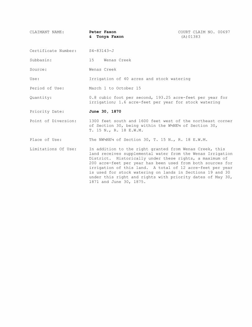


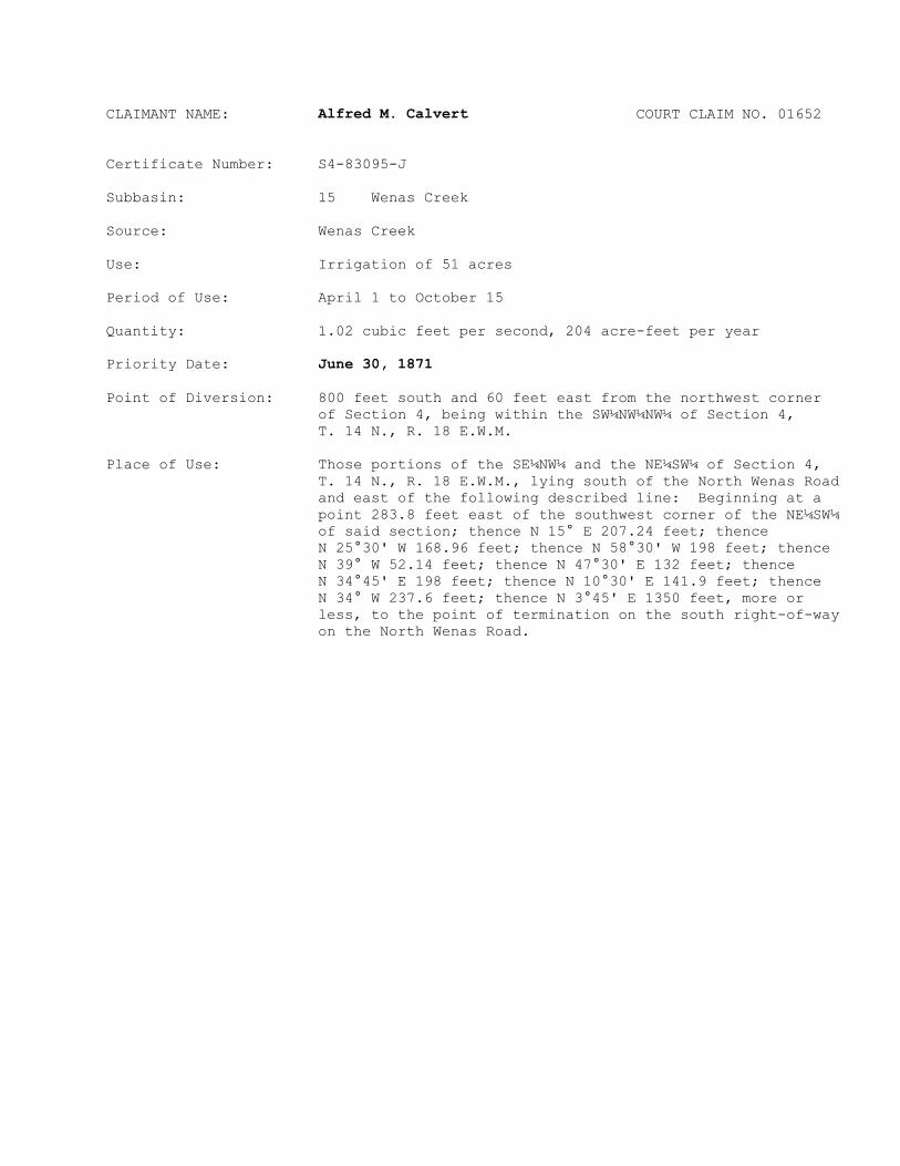

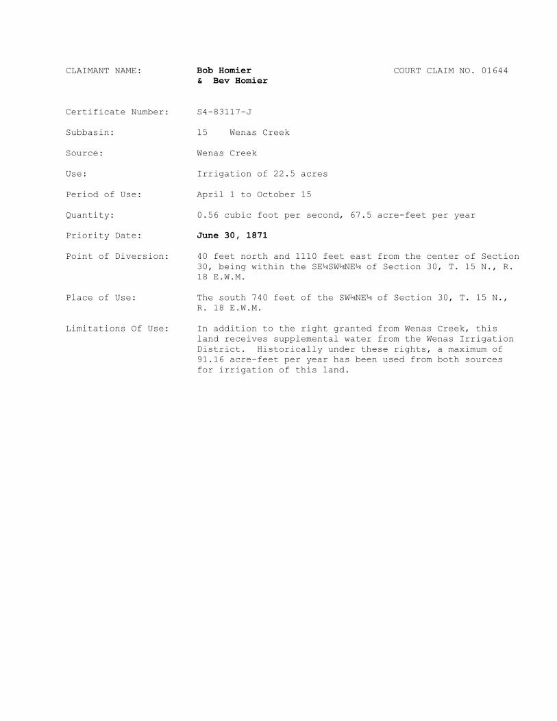


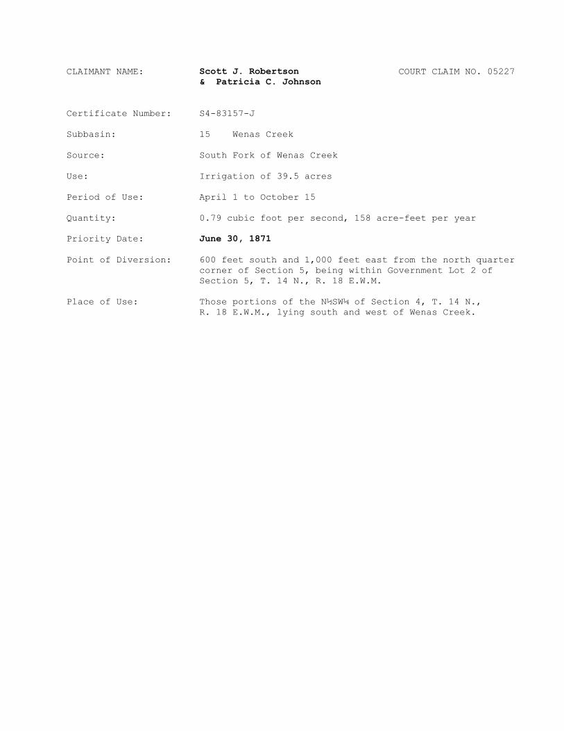


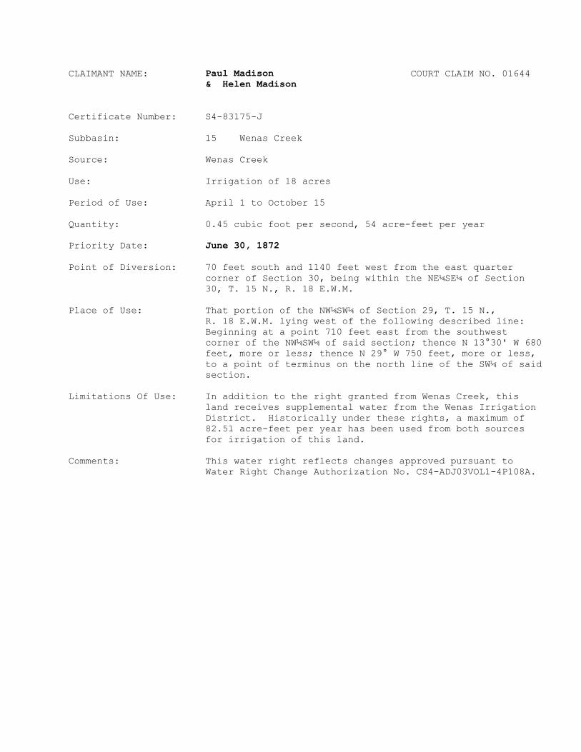


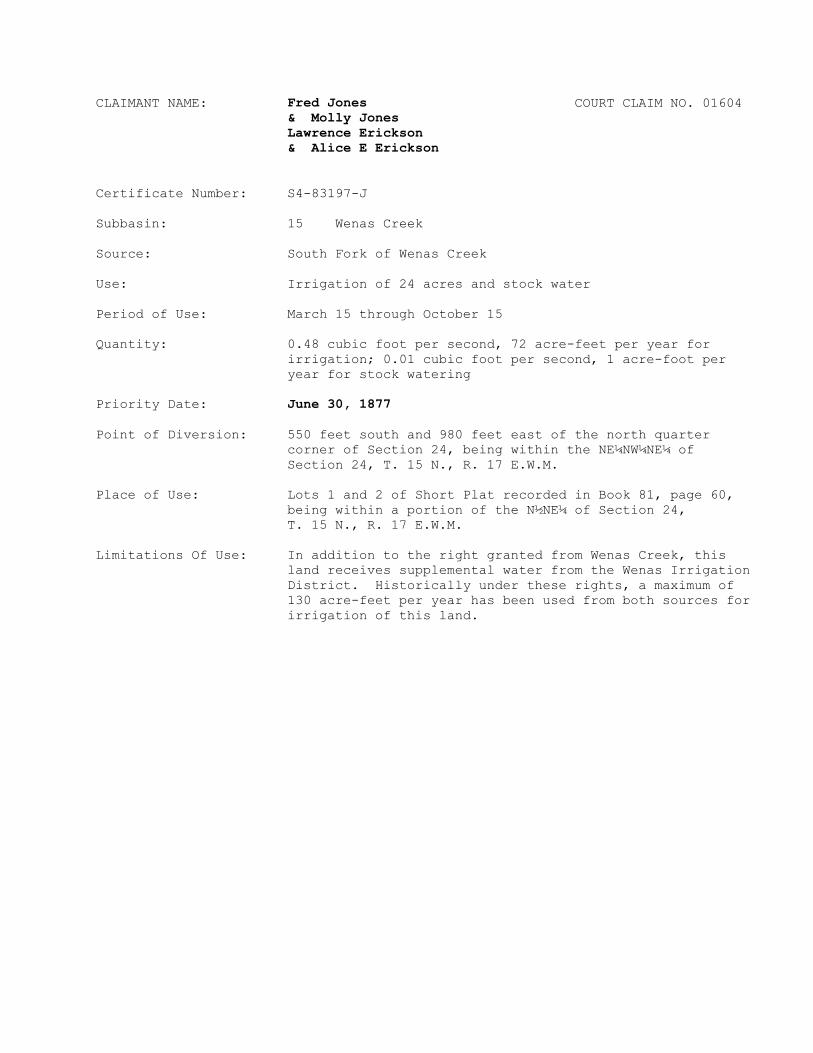


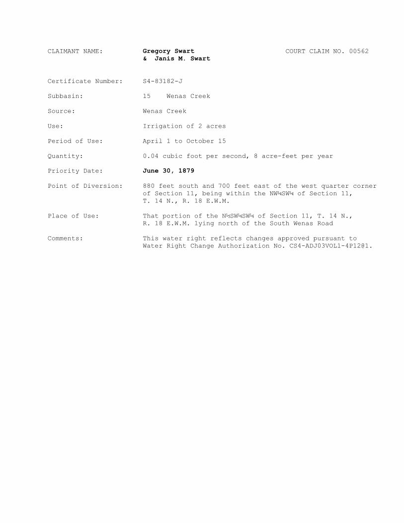

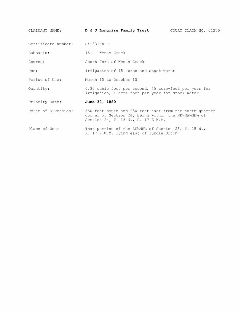


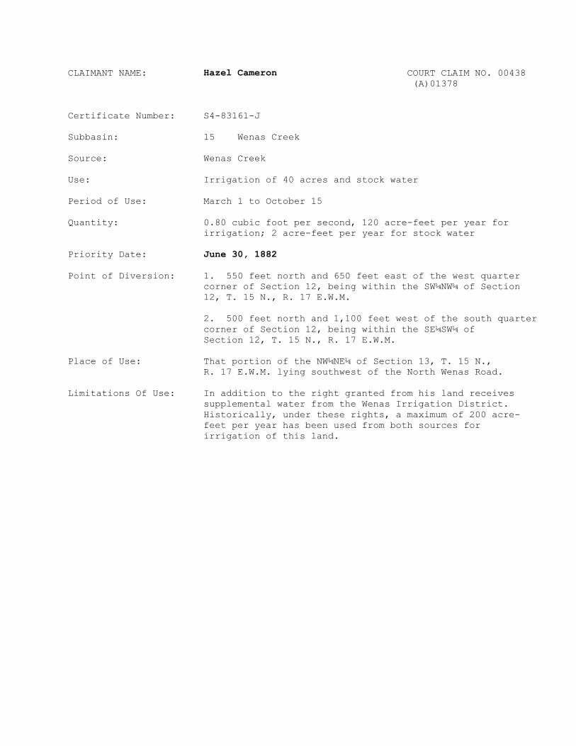


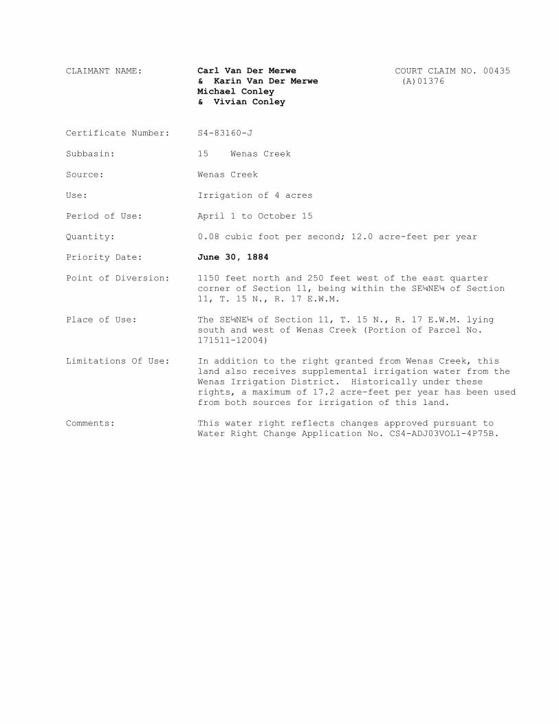


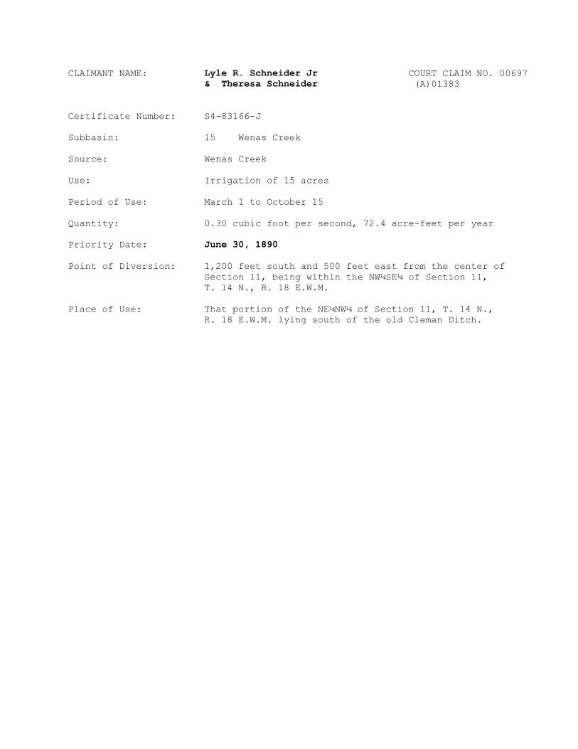


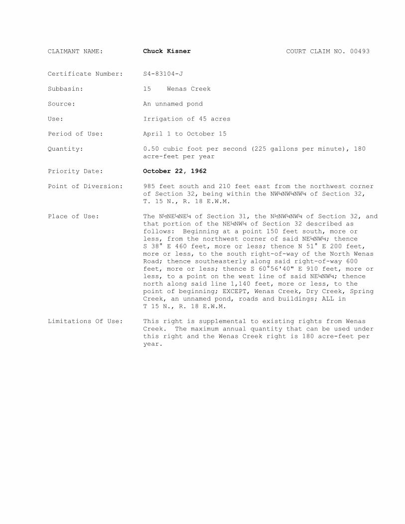


![Ocala Banner. (Ocala, Florida) 1908-08-07 [p ].ufdcimages.uflib.ufl.edu/UF/00/04/87/34/00494/00383.pdf · avengers InterNthac frequently la4ligeetSo1l duplicated remembered Oklawaha](https://static.documents.pub/doc/80x56/5f813ae3c078ce383136a303/ocala-banner-ocala-florida-1908-08-07-p-avengers-internthac-frequently-la4ligeetso1l.jpg)


