Clark, Lincoln, and White Pine Counties Groundwater Development Project Proposed Action Southern Nevada Water Authority (SNWA) has applied to the Bureau of Land Management (BLM) for issuance of rights-of-way to construct and operate a system of regional water supply facilities known as the Clark, Lincoln, and White Pine Counties Groundwater Development (GWD) Project. The GWD Project includes construction and operation of groundwater production wells, water conveyance facilities, and power facilities. The proposed production wells and facilities would be located on public lands managed by BLM in Nevada. No facilities are currently planned in Utah. BLM's action on the right-of-way application is subject to the provisions of the National Environmental Policy Act. The BLM has determined that the Act requires the preparation of an Environmental Impact Statement (EIS). The EIS will consider the potential environmental effects of a right-of-way issuance for construction and operation of the proposed facilities, including the withdrawal of groundwater resources. SNWA anticipates that the total volume of water to be developed and conveyed through the GWD Project would be approximately 180,000 acre-feet per year from Coyote Spring, Delamar, Dry Lake, Tikaboo North, Cave, Spring, and Snake Valleys. As shown on the GWD Project overview map, the primary transmission pipeline would extend north from the Las Vegas Valley, through Coyote Spring, Delamar, Dry Lake, and Spring Valleys. Secondary lateral pipelines are also planned into Snake, Cave, and Tikaboo North Valleys. Smaller conveyance pipelines connecting individual well fields to either the laterals or primary transmission pipeline are also planned. All pipelines would be buried. Final locations for individual well fields, as well as the number of wells in each valley have not yet been determined, but preliminary exploratory areas in those valleys have been identified (see attached segment maps). Pumping stations would be required to transport water over higher elevations and may be required to pump water from some well fields, depending on the final well field locations. An above ground electrical power line (230 KV) would be constructed along the transmission pipeline route, with at least two primary electrical substations. The 230 KV power line would connect, on the north end, into the existing Gondor Substation located near Ely and into the existing Silverhawk Substation located in the Apex area on the south end of the project. Additional electrical distribution lines (69KV or smaller) would be built to smaller substations located adjacent to the pumping stations and well sites. (continued on reverse)
Transcript
Clark, Lincoln, and White Pine Counties Groundwater Development Project
Proposed ActionSouthern Nevada Water Authority (SNWA) has applied to the Bureau of Land Management (BLM) for issuance of rights-of-way to construct and operate a system of regional water supply facilities known as the Clark, Lincoln, and White Pine Counties Groundwater Development (GWD) Project. The GWD Project includes construction and operation of groundwater production wells, water conveyance facilities, and power facilities. The proposed production wells and facilities would be located on public lands managed by BLM in Nevada. No facilities are currently planned in Utah.
BLM's action on the right-of-way application is subject to the provisions of the National Environmental Policy Act. The BLM has determined that the Act requires the preparation of an Environmental Impact Statement (EIS). The EIS will consider the potential environmental effects of a right-of-way issuance for construction and operation of the proposed facilities, including the withdrawal of groundwater resources. SNWA anticipates that the total volume of water to be developed and conveyed through the GWD Project would be approximately 180,000 acre-feet per year from Coyote Spring, Delamar, Dry Lake, Tikaboo North, Cave, Spring, and Snake Valleys.
As shown on the GWD Project overview map, the primary transmission pipeline would extend north from the Las Vegas Valley, through Coyote Spring, Delamar, Dry Lake, and Spring Valleys. Secondary lateral pipelines are also planned into Snake, Cave, and Tikaboo North Valleys. Smaller conveyance pipelines connecting individual well fields to either the laterals or primary transmission pipeline are also planned. All pipelines would be buried.
Final locations for individual well fields, as well as the number of wells in each valley have not yet been determined, but preliminary exploratory areas in those valleys have been identified (see attached segment maps).
Pumping stations would be required to transport water over higher elevations and may be required to pump water from some well fields, depending on the final well field locations.
An above ground electrical power line (230 KV) would be constructed along the transmission pipeline route, with at least two primary electrical substations. The 230 KV power line would connect, on the north end, into the existing Gondor Substation located near Ely and into the existing Silverhawk Substation located in the Apex area on the south end of the project. Additional electrical distribution lines (69KV or smaller) would be built to smaller substations located adjacent to the pumping stations and well sites.
(continued on reverse)
Two hydropower generation turbines would be placed within the pipeline and would generate some electrical power. Disinfection and corrosion control treatment near the terminus of the pipeline would also be required, as well as possible treatment at well heads or conveyance pipelines.
The following are preliminary estimates of the proposed facilities (see individual segments for more specific information by hydrographic basin):
Water Facilities • 115 to 195 wells to produce up to 180,000 acre-feet per year• 235 miles of 54 to 78 inch diameter buried main pipeline• 110 miles of 24 to 36 inch diameter buried lateral pipeline• 6 pumping stations (Coyote Spring, Tikaboo (2), Spring, Snake Valleys)• 40-acre water treatment site in Apex area• 20-million gallon reservoir in northeast Las Vegas Valley
Power Facilities• 250 miles of 230 kV overhead power line• 95 miles of 69kV overhead power line• 2 primary substations • 2 hydro turbine energy recovery facilities (Dry Lake and Coyote Spring Valleys)
Anticipated Schedule
Environmental review process 2005 - 2007Exploratory well drilling, geotechnical, survey, and design 2007 - 2009Primary pipeline construction in all segments except
Snake and Tikaboo North Valleys 2009 - 2015Pipeline construction in Snake Valley 2015 - 2018Pipeline construction in Tikaboo Valley North 2019 - 2021
Project Segments
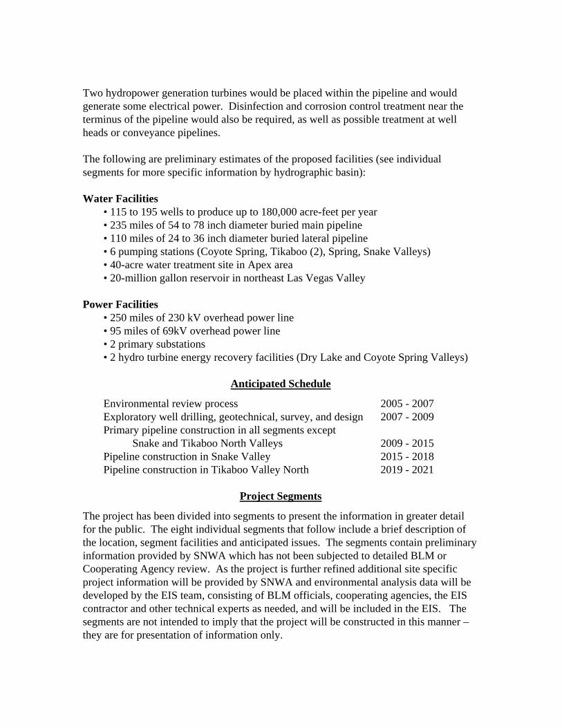
The project has been divided into segments to present the information in greater detail for the public. The eight individual segments that follow include a brief description of the location, segment facilities and anticipated issues. The segments contain preliminary information provided by SNWA which has not been subjected to detailed BLM or Cooperating Agency review. As the project is further refined additional site specific project information will be provided by SNWA and environmental analysis data will be developed by the EIS team, consisting of BLM officials, cooperating agencies, the EIS contractor and other technical experts as needed, and will be included in the EIS. The segments are not intended to imply that the project will be constructed in this manner –they are for presentation of information only.
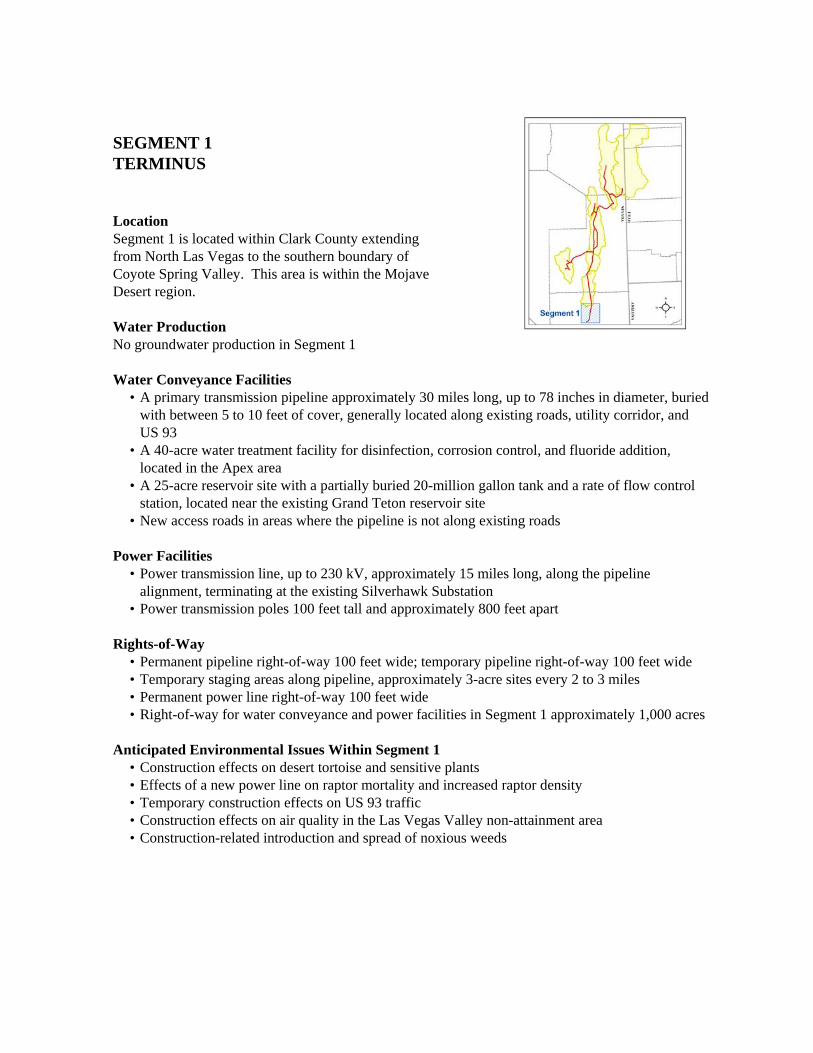
SEGMENT 1 TERMINUS
LocationSegment 1 is located within Clark County extending from North Las Vegas to the southern boundary of Coyote Spring Valley. This area is within the Mojave Desert region.
Water ProductionNo groundwater production in Segment 1
Water Conveyance Facilities• A primary transmission pipeline approximately 30 miles long, up to 78 inches in diameter, buried
with between 5 to 10 feet of cover, generally located along existing roads, utility corridor, and US 93
• A 40-acre water treatment facility for disinfection, corrosion control, and fluoride addition, located in the Apex area
• A 25-acre reservoir site with a partially buried 20-million gallon tank and a rate of flow control station, located near the existing Grand Teton reservoir site
• New access roads in areas where the pipeline is not along existing roads
Power Facilities• Power transmission line, up to 230 kV, approximately 15 miles long, along the pipeline
alignment, terminating at the existing Silverhawk Substation• Power transmission poles 100 feet tall and approximately 800 feet apart
Rights-of-Way• Permanent pipeline right-of-way 100 feet wide; temporary pipeline right-of-way 100 feet wide • Temporary staging areas along pipeline, approximately 3-acre sites every 2 to 3 miles• Permanent power line right-of-way 100 feet wide• Right-of-way for water conveyance and power facilities in Segment 1 approximately 1,000 acres
Anticipated Environmental Issues Within Segment 1• Construction effects on desert tortoise and sensitive plants• Effects of a new power line on raptor mortality and increased raptor density• Temporary construction effects on US 93 traffic • Construction effects on air quality in the Las Vegas Valley non-attainment area• Construction-related introduction and spread of noxious weeds
SEGMENT 2 COYOTE SPRING VALLEY BASIN
LocationSegment 2 is located within Clark and Lincoln counties, extending from the southern to the northern boundary of Coyote Spring Valley. This area is within the Mojave Desert region.
Water Production• SNWA has applications for up to 27,560 acre-feet per year of water rights in Coyote Spring
Valley; SNWA has an agreement to provide approximately half of any permitted water rights to Moapa Valley Water District
• Potential well exploratory area in the central part of the valley, on private lands (owned by Coyote Spring Investment)
• Preliminary estimate of 10 to 15 groundwater production wells, completed in alluvium and carbonate rocks
Water Conveyance Facilities• A primary transmission pipeline approximately 40 miles long, up to 78 inches in diameter, buried
with between 5 to 10 feet of cover, located along US 93
Power Facilities• Power transmission line, up to 230 kV, approximately 40 miles long, along the pipeline alignment• Power transmission poles 100 feet tall approximately 800 feet apart• A 10-acre hydroturbine energy recovery facility, on the pipeline in northern Coyote Spring Valley
Rights-of-Way• Permanent pipeline right-of-way 100 feet wide; temporary pipeline right-of-way 100 feet wide • Temporary staging areas along pipeline, approximately 3-acre sites every 2 to 3 miles• Permanent power line right-of-way 100 feet wide• Right-of-way for water conveyance and power facilities in Segment 2 approximately 1,500 acres
Anticipated Environmental Issues Within Segment 2• Construction effects on desert tortoise and sensitive plants• Effects of a new power line on raptor mortality and increased raptor density• Temporary construction effects on US 93 traffic• Construction-related introduction and spread of noxious weeds• Visual effects of construction disturbance and permanent facilities• Effects of groundwater pumping on springs and spring dependent species, including the Muddy
River Springs• Effects of groundwater pumping on existing water rights and wells
SEGMENT 3DELAMAR VALLEY BASIN
LocationSegment 3 is located within Lincoln County extending from the southern boundary of Pahranagat Valley to the northern boundary of Delamar Valley. This area is within a transition zone between the Mojave Desert and Great Basin region.
Water Production• SNWA has applications for up to 11,580 acre-feet per year of water rights in Delamar Valley • Potential well exploratory area on federal lands in southern and east-central part of valley • Preliminary estimate of 10 to 15 groundwater production wells, completed in alluvial, volcanic,
and carbonate rocks
Water Conveyance Facilities• A primary transmission pipeline approximately 30 miles long, up to 72 inches in diameter, buried
with between 5 to 10 feet of cover, generally located along a powerline and existing unpaved road through the central part of Delamar valley
Power Facilities• Power transmission line, up to 230 kV, approximately 30 miles long, along the pipeline
alignment• Power transmission poles 100 feet tall approximately 800 feet apart• A 10-acre substation in the central part of Delamar Valley
Rights-of-Way• Permanent pipeline right-of-way 100 feet wide; temporary pipeline right-of-way 100 feet wide • Temporary staging areas along pipeline, approximately 3-acre sites every 2 to 3 miles• Permanent power line right-of-way 100 feet wide• Right-of-way for water conveyance and power facilities in Segment 3 approximately 1,100 acres
Anticipated Environmental Issues Within Segment 3• Construction effects on sensitive plants and small mammals, including bats • Effects of a new power line on raptor mortality and increased raptor density• Effects on existing grazing allotments• Construction-related introduction and spread of noxious weeds• Visual effects of construction disturbance and permanent facilities• Effects of groundwater pumping on springs and spring-dependent sensitive species in
Pahranagat Valley, including Pahranagat National Wildlife Refuge• Effects of groundwater pumping on existing water rights and wells
SEGMENT 4DRY LAKE VALLEY BASIN
LocationSegment 4 is located within Lincoln County extending from the southern to the northern boundary of Dry Lake Valley. This area is within the Great Basin region.
Water Production• SNWA has applications for up to 11,580 acre-feet
per year of water rights in Dry Lake Valley • Up to five potential well exploratory areas on federal lands in southern, central, and northern
part of the valley • Preliminary estimate of 10 to 15 groundwater production wells, completed in alluvial, volcanic,
and carbonate rocks
Water Conveyance Facilities• A primary transmission pipeline approximately 65 miles long, up to 72 inches in diameter, buried
with between 5 to 10 feet of cover, located along existing unpaved road through the central part of the valley; a possible optional alignment of approximately 30 miles would go along the western side of the valley
Power Facilities• Power transmission line, up to 230 kV, approximately 65 miles long, along the pipeline alignment• Power transmission poles 100 feet tall approximately 800 feet apart• A 10-acre hydroturbine energy recovery facility, on the pipeline in the central part of the valley
Rights-of-Way• Permanent pipeline right-of-way 100 feet wide; temporary pipeline right-of-way 100 feet wide • Temporary staging areas along pipeline, approximately 3-acre sites every 2 to 3 miles• Permanent power line right-of-way 100 feet wide• Right-of-way for water conveyance and power facilities in Segment 4 approximately 2,500 acres
Anticipated Environmental Issues Within Segment 4• Construction effects on sensitive plants, sage grouse, small mammals (including pygmy rabbit
and bats), and big game migration and seasonal habitat • Effects of a new power line on raptor mortality and increased raptor density• Effects on existing grazing allotments• Construction-related introduction and spread of noxious weeds• Visual effects of construction disturbance and permanent facilities• Effects of groundwater pumping on springs and spring-dependent sensitive species in
Pahranagat, southern White River, and northern Lake valleys• Effects of groundwater pumping on existing water rights and wells
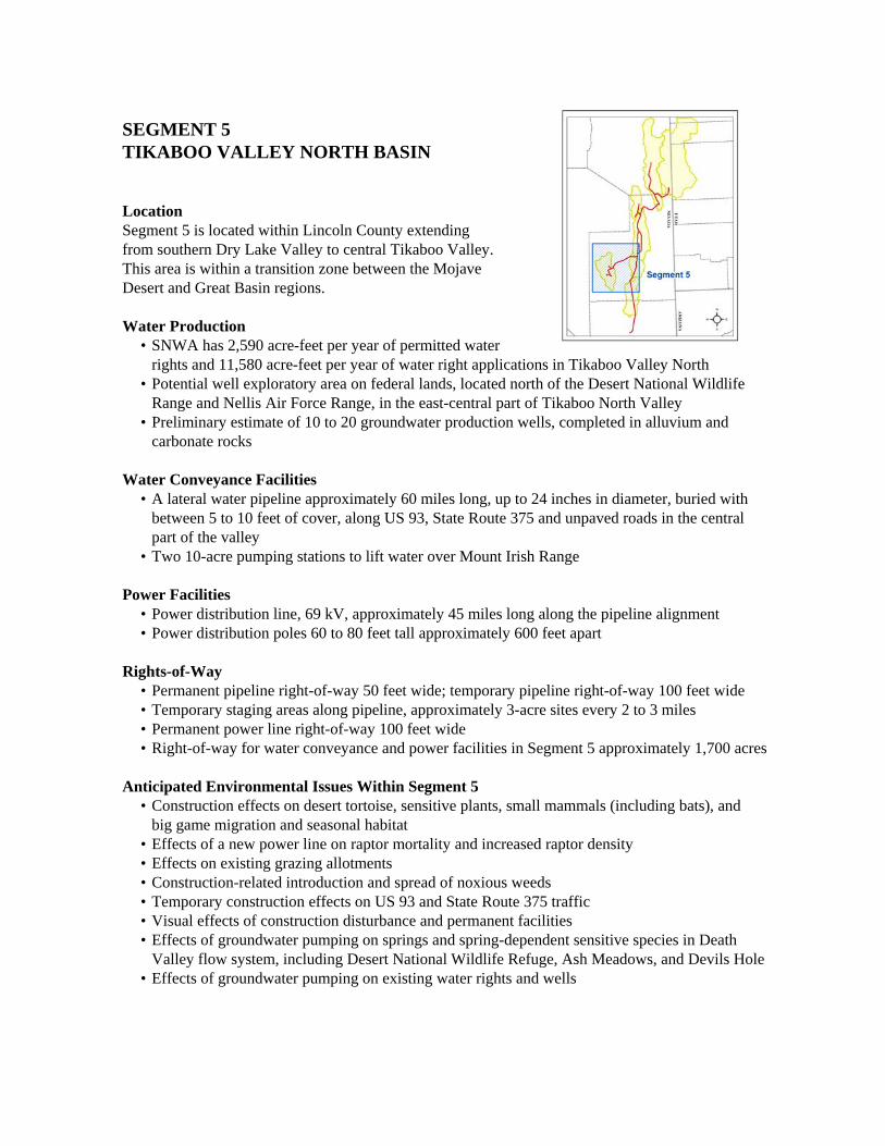
SEGMENT 5TIKABOO VALLEY NORTH BASIN
LocationSegment 5 is located within Lincoln County extending from southern Dry Lake Valley to central Tikaboo Valley. This area is within a transition zone between the Mojave Desert and Great Basin regions.
Water Production• SNWA has 2,590 acre-feet per year of permitted water
rights and 11,580 acre-feet per year of water right applications in Tikaboo Valley North • Potential well exploratory area on federal lands, located north of the Desert National Wildlife
Range and Nellis Air Force Range, in the east-central part of Tikaboo North Valley • Preliminary estimate of 10 to 20 groundwater production wells, completed in alluvium and
carbonate rocks
Water Conveyance Facilities• A lateral water pipeline approximately 60 miles long, up to 24 inches in diameter, buried with
between 5 to 10 feet of cover, along US 93, State Route 375 and unpaved roads in the central part of the valley
• Two 10-acre pumping stations to lift water over Mount Irish Range
Power Facilities • Power distribution line, 69 kV, approximately 45 miles long along the pipeline alignment• Power distribution poles 60 to 80 feet tall approximately 600 feet apart
Rights-of-Way• Permanent pipeline right-of-way 50 feet wide; temporary pipeline right-of-way 100 feet wide• Temporary staging areas along pipeline, approximately 3-acre sites every 2 to 3 miles• Permanent power line right-of-way 100 feet wide• Right-of-way for water conveyance and power facilities in Segment 5 approximately 1,700 acres
Anticipated Environmental Issues Within Segment 5• Construction effects on desert tortoise, sensitive plants, small mammals (including bats), and
big game migration and seasonal habitat • Effects of a new power line on raptor mortality and increased raptor density• Effects on existing grazing allotments• Construction-related introduction and spread of noxious weeds• Temporary construction effects on US 93 and State Route 375 traffic• Visual effects of construction disturbance and permanent facilities• Effects of groundwater pumping on springs and spring-dependent sensitive species in Death
Valley flow system, including Desert National Wildlife Refuge, Ash Meadows, and Devils Hole• Effects of groundwater pumping on existing water rights and wells
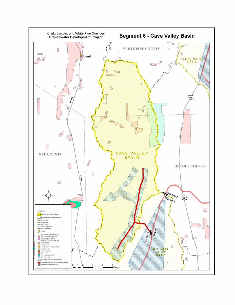
SEGMENT 6CAVE VALLEY BASIN
LocationSegment 6 is located within Lincoln County extending from northern Dry Lake Valley to southeastern and central Cave Valley. This area is within the Great Basin region.
Water Production• SNWA has applications for up to 11,580 acre-feet per year
of water rights in Cave Valley• Potential well exploratory area on federal lands in southern part of valley• Preliminary estimate of 10 to 15 groundwater production wells, completed in alluvium and
carbonate rocks
Water Conveyance Facilities• A lateral water pipeline approximately 20 miles long, up to 24 inches in diameter, buried with
between 5 to 10 feet of cover, along unpaved roads in the southern part of Cave Valley
Power Facilities• Power distribution line, 69 kV, approximately 20 miles long, along the pipeline alignment• Power distribution poles 60 to 80 feet tall approximately 600 feet apart
Rights-of-Way• Permanent pipeline right-of-way 50 feet wide; temporary pipeline right-of-way 100 feet wide• Temporary staging areas along pipeline, approximately 3-acre sites every 2 to 3 miles• Permanent power line right-of-way 100 feet wide• Right-of-way for water conveyance and power facilities in Segment 6 approximately 600 acres
Anticipated Environmental Issues Within Segment 6• Construction effects on sensitive plants, sage grouse, small mammals (including pygmy rabbit
and bats), and big game migration and seasonal habitat • Effects of a new power line on raptor mortality and increased raptor density• Effects on existing grazing allotments• Construction-related introduction and spread of noxious weeds• Visual effects of construction disturbance and permanent facilities• Effects of groundwater pumping on springs and spring-dependent sensitive species, including
big sage), aquatic riparian (i.e., wetlands and meadows) areas, and associated sensitive species, including southern White River Valley (Kirch Wildlife Management Area)
• Effects of groundwater pumping on existing water rights and wells
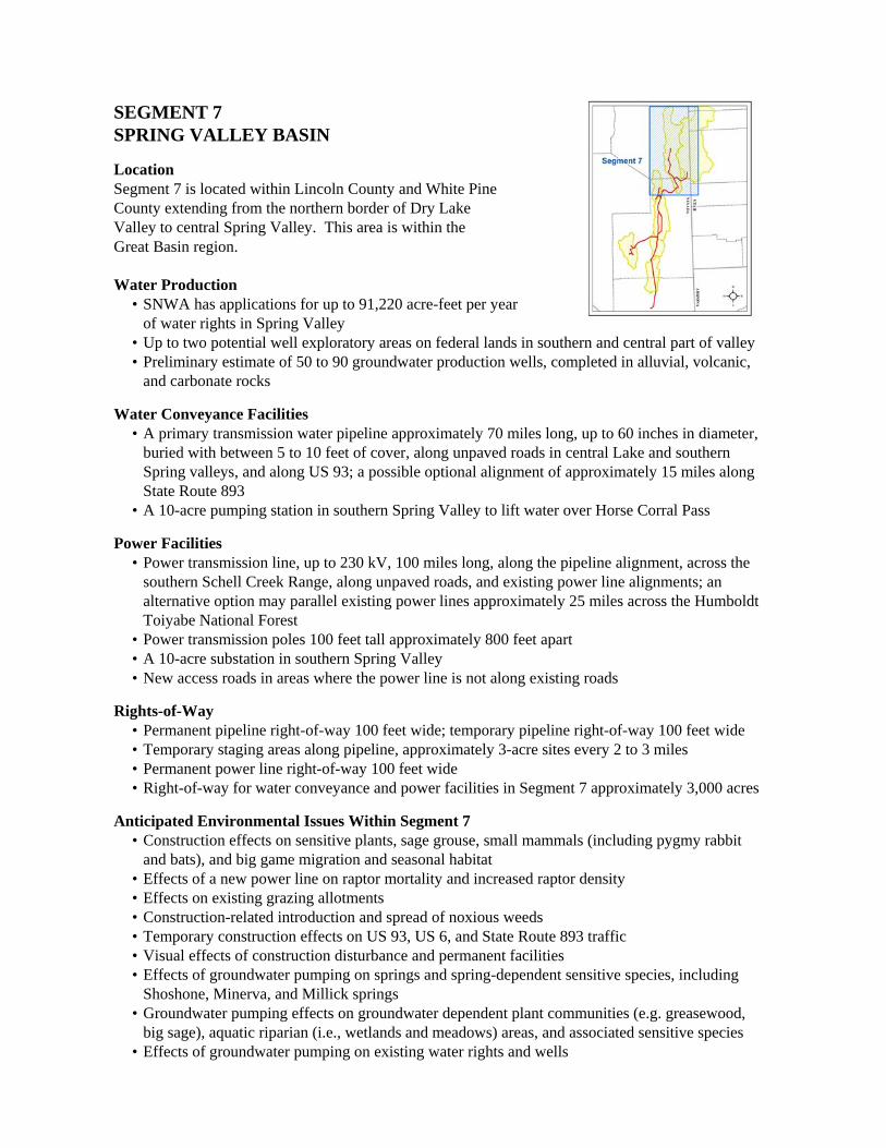
SEGMENT 7SPRING VALLEY BASIN
LocationSegment 7 is located within Lincoln County and White Pine County extending from the northern border of Dry Lake Valley to central Spring Valley. This area is within the Great Basin region.
Water Production• SNWA has applications for up to 91,220 acre-feet per year
of water rights in Spring Valley• Up to two potential well exploratory areas on federal lands in southern and central part of valley• Preliminary estimate of 50 to 90 groundwater production wells, completed in alluvial, volcanic,
and carbonate rocks
Water Conveyance Facilities• A primary transmission water pipeline approximately 70 miles long, up to 60 inches in diameter,
buried with between 5 to 10 feet of cover, along unpaved roads in central Lake and southern Spring valleys, and along US 93; a possible optional alignment of approximately 15 miles along State Route 893
• A 10-acre pumping station in southern Spring Valley to lift water over Horse Corral Pass
Power Facilities• Power transmission line, up to 230 kV, 100 miles long, along the pipeline alignment, across the
southern Schell Creek Range, along unpaved roads, and existing power line alignments; an alternative option may parallel existing power lines approximately 25 miles across the Humboldt Toiyabe National Forest
• Power transmission poles 100 feet tall approximately 800 feet apart• A 10-acre substation in southern Spring Valley • New access roads in areas where the power line is not along existing roads
Rights-of-Way• Permanent pipeline right-of-way 100 feet wide; temporary pipeline right-of-way 100 feet wide• Temporary staging areas along pipeline, approximately 3-acre sites every 2 to 3 miles• Permanent power line right-of-way 100 feet wide• Right-of-way for water conveyance and power facilities in Segment 7 approximately 3,000 acres
Anticipated Environmental Issues Within Segment 7• Construction effects on sensitive plants, sage grouse, small mammals (including pygmy rabbit
and bats), and big game migration and seasonal habitat • Effects of a new power line on raptor mortality and increased raptor density• Effects on existing grazing allotments• Construction-related introduction and spread of noxious weeds• Temporary construction effects on US 93, US 6, and State Route 893 traffic• Visual effects of construction disturbance and permanent facilities• Effects of groundwater pumping on springs and spring-dependent sensitive species, including
Shoshone, Minerva, and Millick springs• Groundwater pumping effects on groundwater dependent plant communities (e.g. greasewood,
big sage), aquatic riparian (i.e., wetlands and meadows) areas, and associated sensitive species• Effects of groundwater pumping on existing water rights and wells
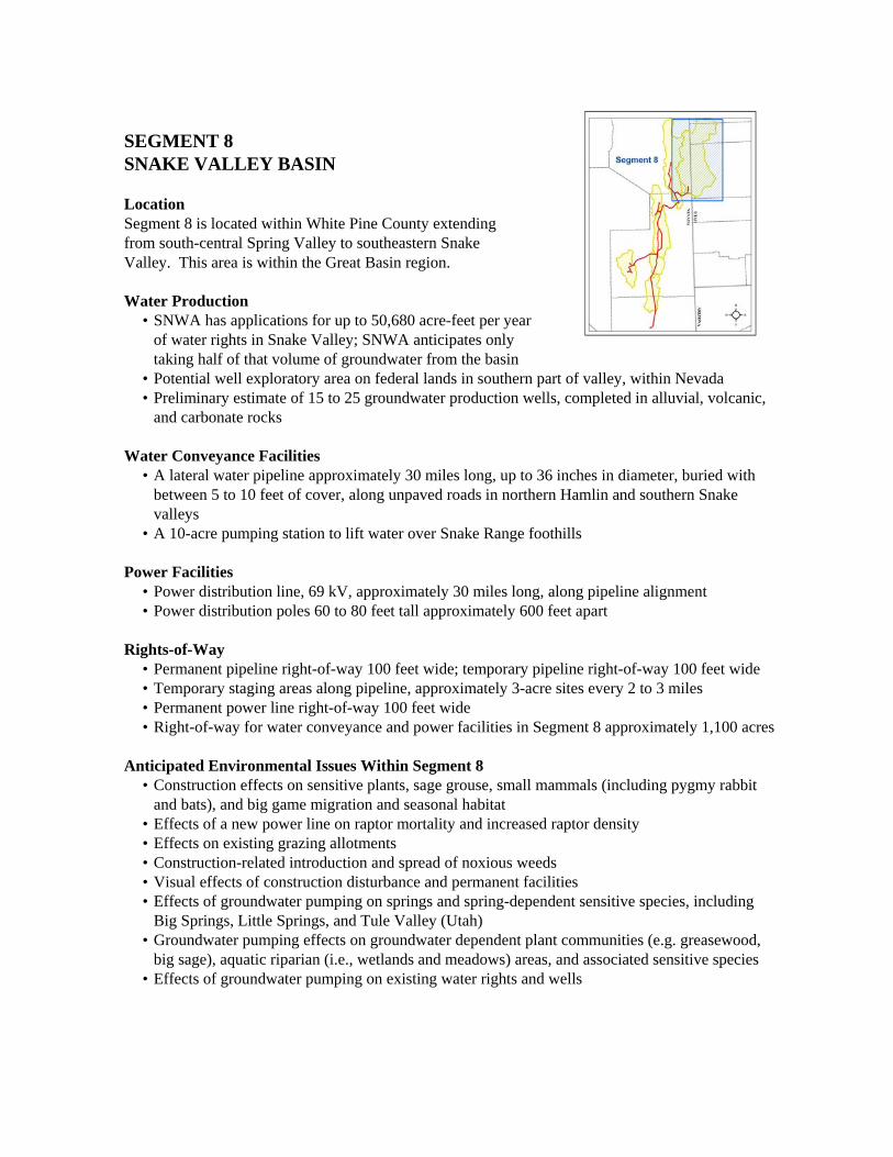
SEGMENT 8SNAKE VALLEY BASIN
LocationSegment 8 is located within White Pine County extending from south-central Spring Valley to southeastern Snake Valley. This area is within the Great Basin region.
Water Production• SNWA has applications for up to 50,680 acre-feet per year
of water rights in Snake Valley; SNWA anticipates onlytaking half of that volume of groundwater from the basin
• Potential well exploratory area on federal lands in southern part of valley, within Nevada• Preliminary estimate of 15 to 25 groundwater production wells, completed in alluvial, volcanic,
and carbonate rocks
Water Conveyance Facilities• A lateral water pipeline approximately 30 miles long, up to 36 inches in diameter, buried with
between 5 to 10 feet of cover, along unpaved roads in northern Hamlin and southern Snake valleys
• A 10-acre pumping station to lift water over Snake Range foothills
Power Facilities• Power distribution line, 69 kV, approximately 30 miles long, along pipeline alignment• Power distribution poles 60 to 80 feet tall approximately 600 feet apart
Rights-of-Way• Permanent pipeline right-of-way 100 feet wide; temporary pipeline right-of-way 100 feet wide• Temporary staging areas along pipeline, approximately 3-acre sites every 2 to 3 miles• Permanent power line right-of-way 100 feet wide• Right-of-way for water conveyance and power facilities in Segment 8 approximately 1,100 acres
Anticipated Environmental Issues Within Segment 8• Construction effects on sensitive plants, sage grouse, small mammals (including pygmy rabbit
and bats), and big game migration and seasonal habitat • Effects of a new power line on raptor mortality and increased raptor density• Effects on existing grazing allotments• Construction-related introduction and spread of noxious weeds• Visual effects of construction disturbance and permanent facilities• Effects of groundwater pumping on springs and spring-dependent sensitive species, including
Big Springs, Little Springs, and Tule Valley (Utah)• Groundwater pumping effects on groundwater dependent plant communities (e.g. greasewood,
big sage), aquatic riparian (i.e., wetlands and meadows) areas, and associated sensitive species• Effects of groundwater pumping on existing water rights and wells


![Board Meeting Agenda 060518 [Autosaved] - POSGCD.ORG · 1. Texas Alliance of Groundwater Districts Meeting of May 21 -22, 2018 2. Milam and Burleson Counties Groundwater Summit of](https://static.documents.pub/doc/80x56/601d0d9a457edd0d43126cee/board-meeting-agenda-060518-autosaved-1-texas-alliance-of-groundwater-districts.jpg)


