42
Class #21: October 18, 2010 1 Class #21: Monday, October 18, 2010 Fronts
Class #21: October 18, 2010 1
Class #21: Monday, October 18, 2010
Fronts
Class #21: October 18, 2010 2
Fronts
• Air masses are important in themselves, and at their boundaries, fronts occur.
• A front is the transition zone between two different air masses.
• Fronts were named around the time of World War I (1910s) because they had disruptive weather and looked like the boundaries on military maps separating armies.
Class #21: October 18, 2010 3
Class #21: October 18, 2010 4
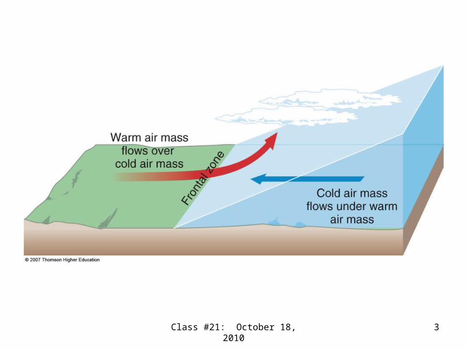
The generic front
• Is the boundary between 2 (3 for the occluded front) air masses of differing temperature.
• Slopes in the vertical up from the surface toward the colder air mass.
• Always has the warmer air mass above the colder air mass (never the reverse).
• Is the scene of frontal lifting if winds blow in part across the front.
Class #21: October 18, 2010 5
The generic front (continued)
• Always has a temperature contrast at the surface between the two air masses.
• Is of synoptic scale along the front and mesoscale across the front.
• Has a cyclonic (counterclockwise in NH) wind shift, a minimum (trough) in surface pressure, and usually a change in humidity across the front.

Class #21: October 18, 2010 6
The generic front (continued)
• Looks like a line on a surface weather map.
• Is called a frontal zone where it meets the ground on the surface weather map.
• Is an area where weather conditions change rapidly over short distances (maybe even a few miles) from one air mass to another.
Class #21: October 18, 2010 7
Different types of fronts
• Stationary front: – Remains in roughly the same location– Surface winds in both air masses blow along
the front– Precedes the development of an extratropical
cyclone– Common in the location of the polar front– Separates T and P– More on stationary fronts later
Class #21: October 18, 2010 8
Cold and warm fronts
• Form together when a stationary front starts to move
• Form when the surface winds along a stationary front start to blow across the front
• Form when a stationary front deforms into a comma or wavelike shape
• Form when a surface low center develops on the stationary front

Class #21: October 18, 2010 9

Class #21: October 18, 2010 10
Cold and warm fronts
• Are named by the temperature changes that result after an air mass passes
• Are enhanced by convergence that intensifies contrasts in temperature, pressure, wind, and humidity
• Air is colder after a cold front passes• Air is warmer after a warm front passes
Class #21: October 18, 2010 11
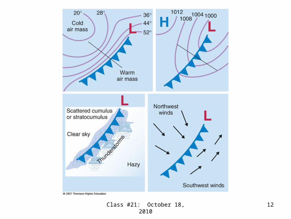
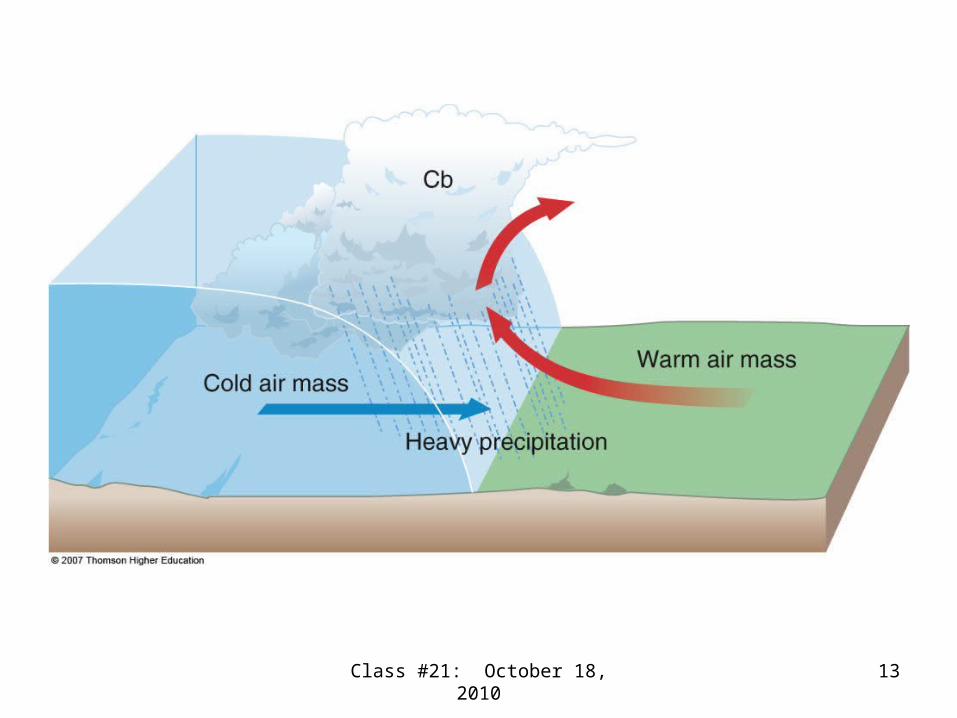
Cold fronts
• Have a slope up from the surface that is closer to vertical than warm fronts.
• Have the colder air mass replacing the warmer air mass at the surface.
• Have some of the most dramatic frontal passages at the surface—greatest weather changes in the shortest amount of time.
Class #21: October 18, 2010 12
Class #21: October 18, 2010 13

Class #21: October 18, 2010 14
Cold fronts
• Move fairly rapidly• May have thunderstorms in the warm
moist unstable air ahead of the front (mT) or along the front
• Usually have fairly narrow rainbands along and across the front
• Frequently lines of thunderstorms called squall lines form ahead of and parallel to cold fronts.
Class #21: October 18, 2010 15
Class #21: October 18, 2010 16
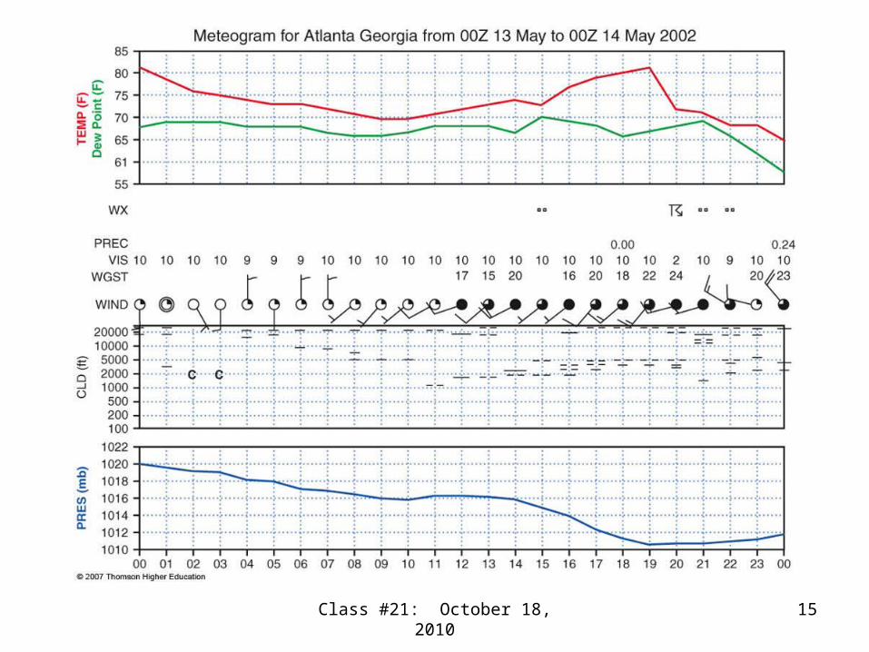
Real cold fronts
• Don’t always look exactly like the idealized fronts in the textbook
• The meteogram shows a frontal passage at about 2200 UTC
• May be dry, with no clouds or precipitation• May have blowing dust• Can cause precipitation even at night
Class #21: October 18, 2010 17
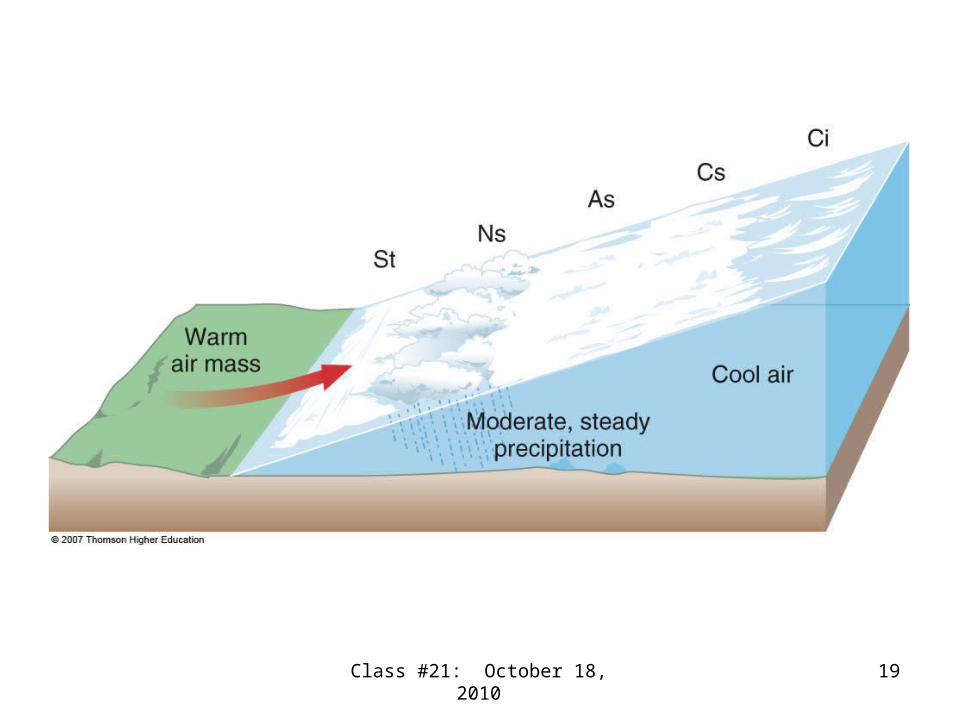
Warm fronts
• Have a slope upward from the ground inclined more towards the horizontal than cold fronts
• Have weaker vertical motions than warm fronts
• Have a special name for the upglide of horizontal and vertical motion called overrunning, warmer air over colder air

Class #21: October 18, 2010 18
Class #21: October 18, 2010 19
Class #21: October 18, 2010 20
Class #21: October 18, 2010 21
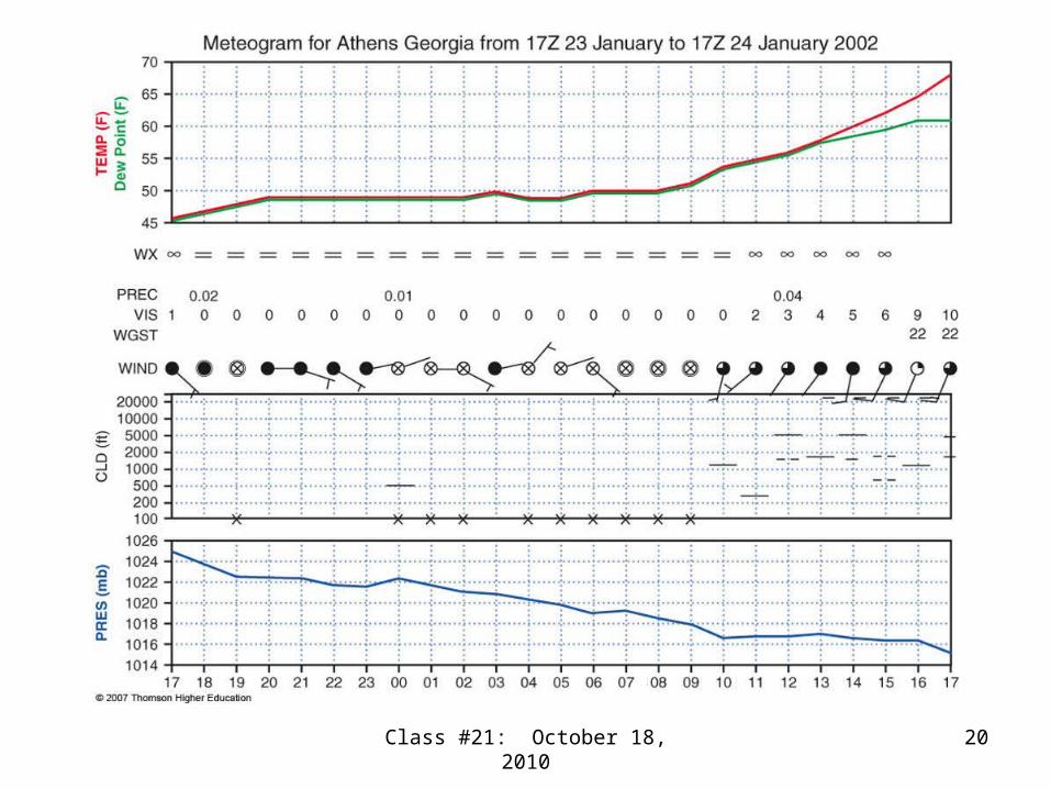
Real warm fronts
• The meteogram shows a warm frontal passage at 1000 UTC
• Move at about half the speed of cold fronts• Have a sequence of layer clouds• Have the highest clouds well ahead of the
front at the surface• Are very 3-dimensional• Can stall, for example in mountains

Class #21: October 18, 2010 22
Real warm fronts
• Can stall when the cold dense air is hard to replace
• Can have broad bands of moderate precipitation
• Can produce long periods of precipitation when they stall
• Can produce frontal fog with evaporation• Are associated with freezing rain and sleet
Class #21: October 18, 2010 23
Stationary fronts (continued)
• Weather along a stationary front can resemble a warm front
• Although the front is stationary at the surface, strong winds aloft may blow across the front aloft, causing overrunning
• Can have extended periods of cloudiness and precipitation on the cold side of the front.
• Can have a jet stream aloft

Early stages in the life cycle of the extratropical cyclone
Class #21: October 18, 2010 24
Frontal lifting and cloud types
• Frontal lifting is weaker at warm fronts than cold fronts
• Convergence is weaker at warm fronts than cold fronts
• Convection is rare at warm fronts, common with cold fronts
• Layer clouds are common with fronts
Class #21: October 18, 2010 25
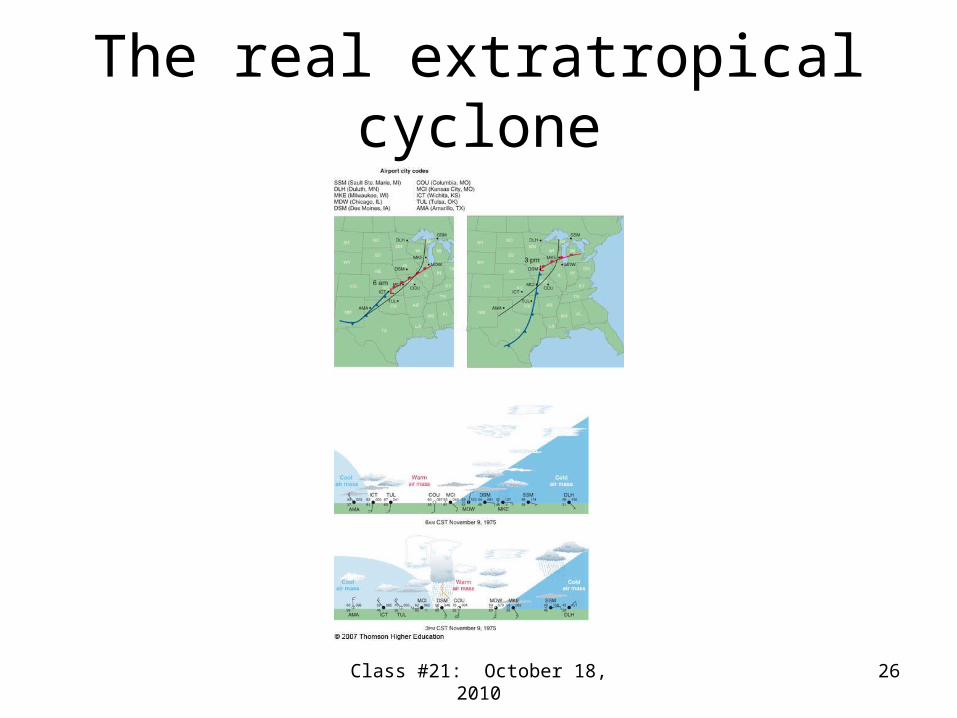
The real extratropical cyclone
Class #21: October 18, 2010 26
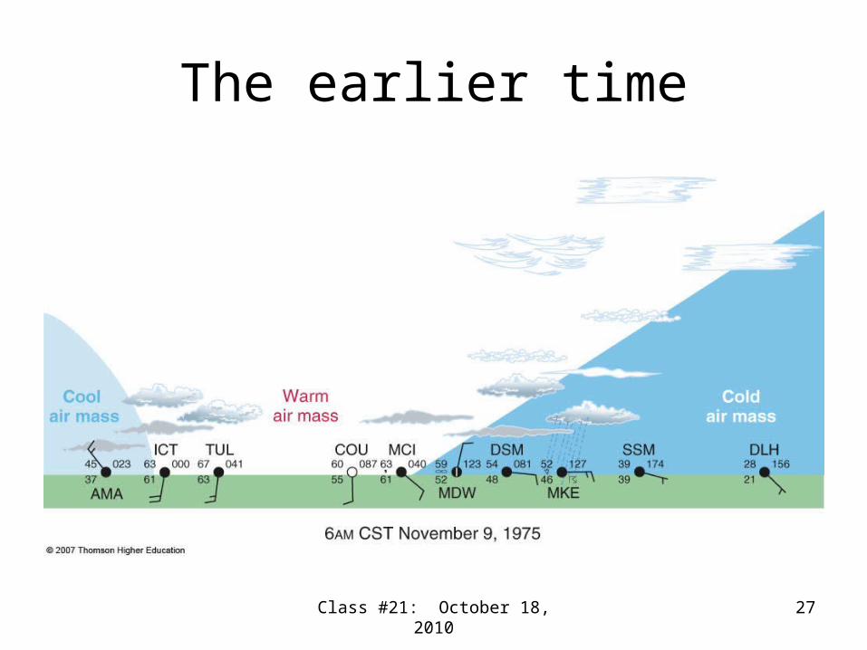
The earlier time
Class #21: October 18, 2010 27
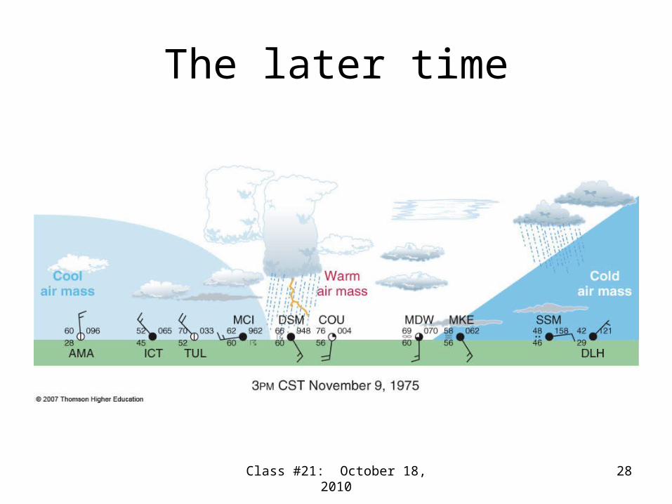
The later time
Class #21: October 18, 2010 28

Frontal inversions, freezing rain, and sleet
Class #21: October 18, 2010 29
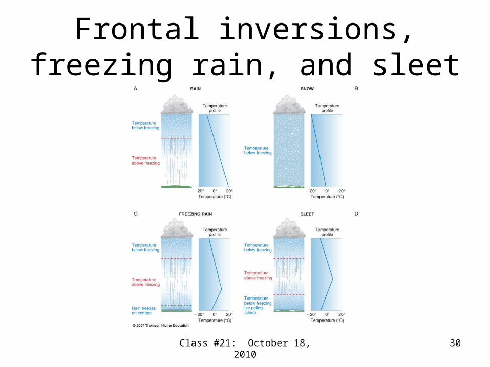
Frontal inversions, freezing rain, and sleet
Class #21: October 18, 2010 30

Later stages in the life cycle of the extratropical cyclone
Class #21: October 18, 2010 31
Class #21: October 18, 2010 32
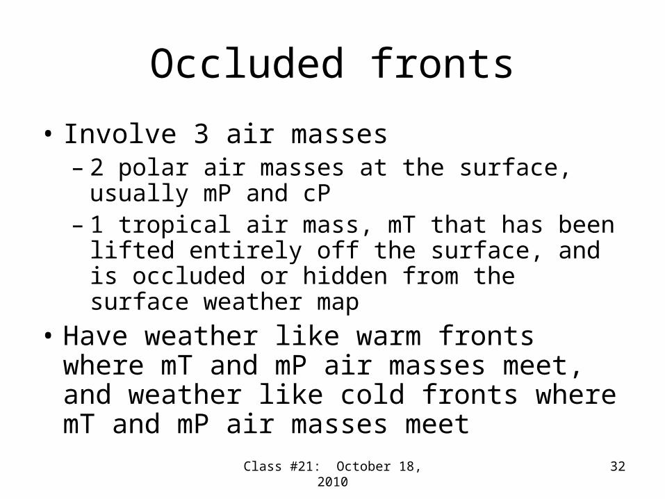
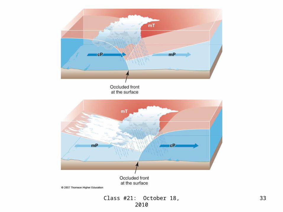
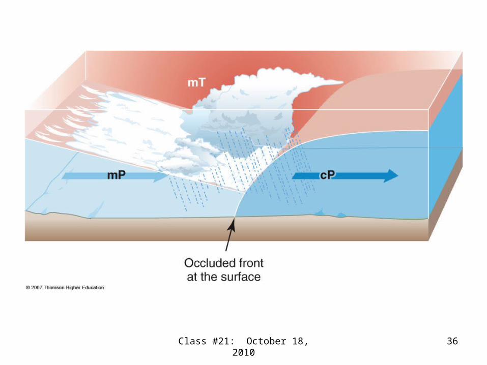
Occluded fronts
• Involve 3 air masses– 2 polar air masses at the surface, usually mP
and cP– 1 tropical air mass, mT that has been lifted
entirely off the surface, and is occluded or hidden from the surface weather map
• Have weather like warm fronts where mT and mP air masses meet, and weather like cold fronts where mT and mP air masses meet
Class #21: October 18, 2010 33
Class #21: October 18, 2010 34
Occluded fronts (continued)
• Are of 2 types, warm occlusions and cold occlusions, named for the change in temperature behind the front.
• Warm occlusions form on the west coast of the U.S. and Europe, when the air mass behind the front is usually from the ocean, mP.
• Cold occlusions frequently form in the eastern half of the U.S., with mP ahead and cP behind the front.

Class #21: October 18, 2010 35
Class #21: October 18, 2010 36

Class #21: October 18, 2010 37
Class #21: October 18, 2010 38
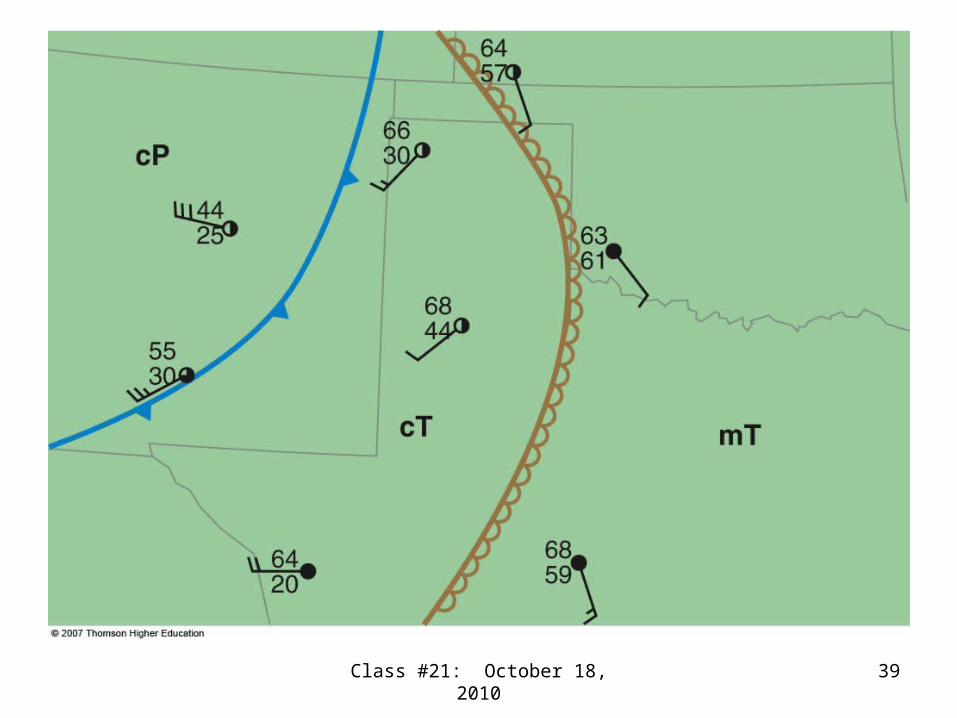
Drylines
• Are not true fronts because there is no temperature contrast across the front.
• Resemble fronts because there is a boundary between air masses, cT and mT.
• Resemble fronts because there is a wind shift, pressure trough, convergence, and often convective clouds along the dryline.
• Occur in West Texas in spring and early summer, and severe weather can occur.
Class #21: October 18, 2010 39

Class #21: October 18, 2010 40
Drylines (continued)
• Have a strong contrast in humidity and wind direction across the front
• Can persist for several days.• Can move westward at night (called the
dew-point front)• Move from west to east during the day• Are a powerful source of convergence• The moister air is lighter, and rises

3-D view of extratropical cyclone life cycle
Class #21: October 18, 2010 41

Divergence aloft and surface low pressure
Class #21: October 18, 2010 42


