CHAPTER FOUR Clay Minerals, Deep Circulation and Climate Nathalie Fagel Contents 1. Introduction 139 2. Methodology: The Clay Toolbox in Marine Sediments 142 2.1. Clay mineral groups in deep-sea sediments 142 2.2. Formation of clay minerals 143 2.3. The origin of clays in deep-sea sediments 145 2.4. Clay particle transport mechanisms 147 2.5. Clay mineral distribution in the world ocean basins 150 2.6. The significance of clays in cenozoic marine sediments 158 2.7. Provenance of detrital inputs 160 2.8. Relationship between clay mineralogy and ocean circulation 163 2.9. Relationship between clay minerals and climate 168 3. Applications: Clays as a Proxy for Paleocirculation 171 3.1. Clay distribution in Arctic Ocean surface sediments 171 3.2. Clay distribution in holocene and last glacial sediments in the North Atlantic 172 3.3. Clay distribution since the last glacial in the southeast Indian Ocean 175 4. Some Perspectives 176 Acknowledgements 176 References 176 1. Introduction The detrital fraction of deep-sea sediments may carry important information about conditions on adjacent continents and about the mechanisms by which material is transported from land to sea (Figure 1). Clay minerals are the main constituents of recent deep-sea or abyssal sediments. Since the late sixties, their role as paleoclimatic and paleoceanographic indicators has been investigated worldwide by X-ray diffraction techniques (Yeroshchev-Shak, 1964; Biscaye, 1965; Berry & Johns, 1966; Chamley, 1967; Griffin, Windom, & Goldberg, 1968; Rateev, Gorbunova, Developments in Marine Geology, Volume 1 r 2007 Elsevier B.V. ISSN 1572-5480, DOI 10.1016/S1572-5480(07)01009-3 All rights reserved. 139
Transcript
C H A P T E R F O U R
DevelopISSN 1
Clay Minerals, Deep Circulation and
Climate
Nathalie Fagel
Contents
1. Introduction
139
2. Methodology: The Clay Toolbox in Marine Sediments
142
2.1. Clay mineral groups in deep-sea sediments
142
2.2. Formation of clay minerals
143
2.3. The origin of clays in deep-sea sediments
145
2.4. Clay particle transport mechanisms
147
2.5. Clay mineral distribution in the world ocean basins
150
2.6. The significance of clays in cenozoic marine sediments
158
2.7. Provenance of detrital inputs
160
2.8. Relationship between clay mineralogy and ocean circulation
163
2.9. Relationship between clay minerals and climate
168
3. Applications: Clays as a Proxy for Paleocirculation
171
3.1. Clay distribution in Arctic Ocean surface sediments
171
3.2. Clay distribution in holocene and last glacial sediments in the
North Atlantic
172
3.3. Clay distribution since the last glacial in the southeast Indian Ocean
175
4. Some Perspectives
176
Acknowledgements
176
References
176
1. Introduction
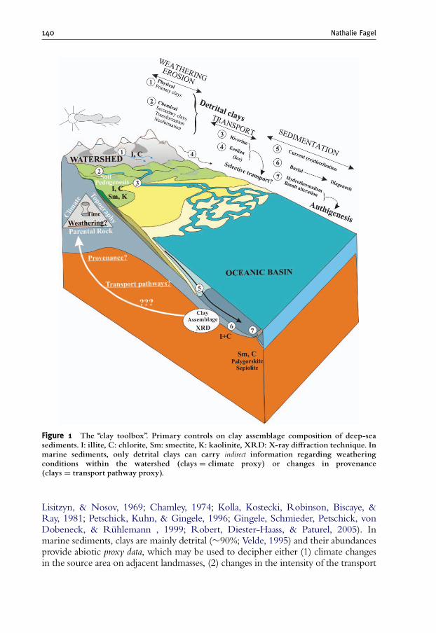
The detrital fraction of deep-sea sediments may carry important informationabout conditions on adjacent continents and about the mechanisms by whichmaterial is transported from land to sea (Figure 1). Clay minerals are the mainconstituents of recent deep-sea or abyssal sediments. Since the late sixties, their role aspaleoclimatic and paleoceanographic indicators has been investigated worldwide byX-ray diffraction techniques (Yeroshchev-Shak, 1964; Biscaye, 1965; Berry & Johns,1966; Chamley, 1967; Griffin, Windom, & Goldberg, 1968; Rateev, Gorbunova,
ments in Marine Geology, Volume 1 r 2007 Elsevier B.V.572-5480, DOI 10.1016/S1572-5480(07)01009-3 All rights reserved.
Figure 1 The ‘‘clay toolbox’’. Primary controls on clay assemblage composition of deep-seasediments. I: illite, C: chlorite, Sm: smectite, K: kaolinite, XRD: X-ray di¡raction technique. Inmarine sediments, only detrital clays can carry indirect information regarding weatheringconditions within the watershed (clays ¼ climate proxy) or changes in provenance(clays ¼ transport pathway proxy).
Nathalie Fagel140
Lisitzyn, & Nosov, 1969; Chamley, 1974; Kolla, Kostecki, Robinson, Biscaye, &Ray, 1981; Petschick, Kuhn, & Gingele, 1996; Gingele, Schmieder, Petschick, vonDobeneck, & Ruhlemann , 1999; Robert, Diester-Haass, & Paturel, 2005). Inmarine sediments, clays are mainly detrital (�90%; Velde, 1995) and their abundancesprovide abiotic proxy data, which may be used to decipher either (1) climate changesin the source area on adjacent landmasses, (2) changes in the intensity of the transport
Clay Minerals, Deep Circulation and Climate 141
agent, or (3) changes in the ocean currents that disperse the terrigenous input(Gingele, De Deckker, Girault, & Guichard, 2004).
In essence, clay mineralogy is a useful tool to constrain the provenance of fine-grained terrigenous sediments (Biscaye, 1965). After much discussion in the literatureabout the usefulness of clay minerals in delineating suspended sediment dispersalroutes and constraining the provenance of fine-grained marine deposits (Biscaye,1965; Hein, Bouma, Hampton, & Ross, 1979), clay mineralogy has been widelyused as a tracer of provenance in studies of the world’s oceans. In these studies, themineralogy of the fine-grained detrital fraction generally reflects the intensity ofcontinental weathering in the source areas (Biscaye, 1965; Griffin et al., 1968; Rateevet al., 1969). Combining clay mineralogy and radiogenic isotope measurements(Sr, Nd and/or Pb) provides further constraints on the identification of the sourcearea (e.g., Grousset, Biscaye, Zindler, Prospero, & Chester, 1988; Fagel, Innocent,Stevenson, & Hillaire-Marcel, 1999; Walter, Hegner, Diekmann, Kuhn, & RutgersVan Der Loeff, 2000; Rutberg, Goldstein, Hemming, & Anderson, 2005).
Clays are sensitive indicators of their environment of formation, and theircomposition may be used to constrain climatic variations which do not affect othersize fractions (Moriarty, 1977). The composition of terrestrial clay mineral reflectsthe prevailing weathering regimes which control the nature and intensity ofpedogenetic processes in continental source areas. Weathering depends primarily onclimate zonation, which determines the intensity of physical and/or chemicalweathering (e.g., Chamley, 1989; Weaver, 1989).
Clay minerals are eroded from soils by rivers, wind or ice and carried intoshallow and deep water masses of the surrounding seas. Their modern distributionpattern on the sea floor provides insight into their propagation by ocean currents(Gingele, De Deckker, & Hillenbrand, 2001b): the dispersal of detrital claysconstrains the transport pathway of suspended fine-grained particles. As such, claysare indirect tracers of water masses. The interpretation of down-core changes in mineralassemblages depends on available information on the modern distribution andsources, as well as independent climate proxy data about the source area. Once therelationship between a specific clay mineral assemblage and a given source, watermass or current system is established, variations of this assemblage in down-coreprofiles may be used to detect fluctuations in the propagation of the water mass orcurrent system (Diekmann et al., 1996; Gingele et al., 1999).
As the distribution of clay minerals in modern oceans appears to be controlled bycontemporaneous climates, marine clays in Cenozoic (and Mesozoic) sediments havebeen widely used to reconstruct paleoclimates (Chamley, 1981). Singer (1984), andlater Thiry (2000), questioned the relevance of using marine detrital clays as acontinental paleoclimate proxy: indeed, changes in marine clay mineral assemblagesdo not systematically reflect changes in weathering conditions in the continentalsource area, but rather changes in source areas or transport media. For older sedi-mentary sequences, diagenesis can completely erase the paleoenvironmental memoryof clay minerals, initially diversified clay assemblages evolving with burial towards ananonymous illite- and chlorite-bearing association with intermediate irregular andregular mixed-layers (e.g., Hower, Eslinger, Hower, & Perry, 1976; Nadeau, Wilson,McHardy, & Tait, 1985; Inoue, 1987). The dominant diagenetic change is the
Nathalie Fagel142
progressive reaction of smectite to illite, which depends primarily on temperature(Hower et al., 1976; Hoffman & Hower, 1979; Srodon & Eberl, 1984). Other thantemperature, the two most important factors are time and fluid chemistry (Eberl &Hower, 1977; Roberson & Lahann, 1981; Ramsayer & Boles, 1986). In sedimentarydeposits characterized by a normal geothermal gradient (�301C/km), burialdiagenesis operates at depths greater than 2,500–3,000m (i.e., at temperatures4801C, Chamley, 1989).
In this chapter, we review the literature in order to describe the relationshipsbetween (1) clay mineral abundance in deep-sea sediments and deep circulation,and (2) clay variability and short- or long-term climate changes. As the presentvolume is dedicated to Proxies in Paleoceanography, we focus on the interpretation ofmarine clay mineral data. The identification and quantification of clay mineralsusing X-ray diffraction methods are described in other methodological textbooks(e.g., Brindley & Brown, 1980; Moore & Reynolds, 1989).
2. Methodology: The Clay Toolbox in Marine Sediments
2.1. Clay Mineral Groups in Deep-Sea Sediments
2.1.1. Definition and identification of clay mineral groupsThe mineral component of the ‘‘clay-sized’’ fraction (o2mm, or even o1mm) ofdeep-sea sediments comprises the common clay minerals montmorillonite (orsmectite), illite, kaolinite and chlorite, with lesser amounts of quartz and feldspars(Windom, 1976). In addition, the mixed-layer minerals palygorskite and sepiolitehave been also identified in this size fraction (Windom, 1976). Clay minerals areidentified by their characteristic basal X-ray diffraction maxima (i.e., ‘‘reflection’’ or‘‘peak’’; Brindley & Brown, 1980; Moore & Reynolds, 1989). The term ‘‘clayminerals’’ refers to mineral groups rather than specific mineralogical species. ‘‘Illite’’ isused ‘‘as a general term for the clay mineral constituent of argillaceous sedimentsbelonging to the mica group’’ (definition from Grim, Bray, & Bradley, 1937). Illitesare characterized by a 10 A reflection which is affected neither by glycolation norheating. The term is used in the same general sense as ‘‘montmorillonite’’ or‘‘kaolinite’’, that is, to refer to a group of minerals. Any material which expands to17 A upon glycolation is assigned to the montmorillonite group (Biscaye, 1965). Theterm ‘‘smectite’’ is often used in more recent works, and encompasses pure smectitebut also smectite–illite mixed layers with variable abundances of smectite layers.Chlorites are defined by a 14 A reflection which is affected neither by solvatation nor,usually, by heating (except if vermiculite is present). Kaolinite is identified by a 7 Areflection that disappears above 5001C. Minor quantities of non-clay minerals arepresent in the terrigenous fine-grained component of deep-sea sediments.
2.1.2. Clay mineral classificationClay minerals belong to the phyllosilicate family (Brindley & Brown, 1980; Cailliere,Henin, & Rautureau, 1982; Moore & Reynolds, 1989). Phyllosilicates are hydrous
Clay Minerals, Deep Circulation and Climate 143
silicate minerals essentially composed of two-dimensional Si-bearing tetrahedral,and Al-bearing octahedral sheets stacked in a regular array (White, 1999). Thefundamental classification criteria retained by the AIPEA (Association InternationalePour l’Etude des Argiles) are the tetrahedral–octahedral sheet combination type (layertype, i.e., 1/1, 2/1 or 2/1/1), the cation content of the octahedral sheets(dioctahedral or trioctahedral), the layer charge and the type of interlayer material(Bailey, 1980).
Kaolinite consists of a combination of one tetrahedral layer and one octahedrallayer (layer type 1/1). It is a dioctahedral mineral with two-thirds of the octahedralsites filled by a trivalent cation (Al or possibly Fe3+). There is no interlayer materialother than H2O.
Illite comprises a combination of two tetrahedral sheets and one intercalatedoctahedral sheet (layer type 2/1). It is a dioctahedral mineral characterized by thepresence of K cations in the interlayer which compensate the charge deficit resultingfrom Al3+ substitution by Si4+ in the tetrahedral sheet.
Smectite is also a 2/1 layer type mineral, but is characterized by variable amountsof the exchangeable cations Na and/or Ca in the interlayer, as well as one or twolayers of water. Smectites are divided into two subgroups. Montmorillonites sensulato comprise all dioctahedral smectites, i.e., montmorilllonite sensu stricto, charac-terized by an octahedral Mg2+ charge, beidellite, characterized by a tetrahedral Al3+
charge, and its Fe-rich end-member nontronite (tetrahedral Fe3+ charge). Saponitessensu lato consist of a trioctahedral mineral which includes either an octahedralcharge (Mg2+ in stevensite, Li+ and F+ in hectorite) or an octahedral Mg2+ chargeand a tetrahedral Al3+ charge in saponite sensu stricto.
Chlorite is also composed of three sheets, two tetrahedral ones and an octahedralone, but its interlayer space is taken up by a hydroxide layer (layer type 2/1/1).In sedimentary environments, although chlorites are mainly trioctahedral with3/3 octahedral sites filled by bivalent cations such as Fe, Mg, Mn or, morerarely, monovalent cations (Li, Ni), some dioctahedral species are possible (e.g.,sudoite). Their chemical composition is complex and varied due to numerouspossible substitutions in both the tetrahedral and/or octahedral layers and in theinterlayer.
Mixed layers are formed by the regular or irregular stacking of two or more layertypes. Not all possible combinations are observed in sedimentary environments (seereported occurrences in Thorez, 1986).
Palygorskite and sepiolite are fibrous clay minerals comprising two discontinuoustetrahedral sheets and one continuous octahedral sheet (modulated 2/1 layer type).They are characterized by a ribbon structure with a large space available for water,hydroxyl and exchangeable cations, more specifically Mg in sepiolite and Al inpalygorskite (Cailliere et al., 1982).
2.2. Formation of Clay Minerals
Sedimentary clays are divided into two main categories according to their origin(Figure 1). Clay minerals are either formed by in situ precipitation from a con-centrated solution in closed continental or marine sedimentary basins (authigenic
Nathalie Fagel144
clays) or by weathering processes on the continent (detrital clays). Authigenesis is aminor process which accounts for less than 10% of clay minerals (Velde, 1995),although it may be important locally. In deep-sea environments, authigenic claysresult from the weathering of basaltic oceanic crust or hydrothermal alteration(Chamley, 1989; Weaver, 1989). The nature and chemical composition of clays arestrongly controlled by reaction temperatures (Velde, 1992). Authigenic deep-seaclays are mainly Fe- and/or Mg-rich minerals, including various species of smectites(nontronite, saponite), micas (celadonite), chlorites and fibrous clays (palygorskite,sepiolite; Velde, 1995).
Whereas authigenic clays provide insight into the geochemical environment,detrital clays hold a record of weathering conditions in the adjacent landmass(Velde, 1995). Detrital clays result from the physical breakdown of parental rocks(primary minerals) or from the selective dissolution of pre-existing clay andnon-clay minerals and growth of secondary minerals in soils (Allen, 1997). Undernormal pH conditions, water attack or hydrolysis, is the main chemical weatheringprocess involved (Chamley, 1989). During pedogenesis, secondary clays form bytransformation processes or neoformation. Transformed clays are the result ofcation loss due to the opening of the sheet structure (degradation) or, conversely,cation addition to repair slightly altered clay (rejuvenation) or to form a newmineral (aggradation; Thorez, 1989). Neoformed clays are formed by recom-bination and precipitation of ions from a leachate. The intensity of chemicalweathering, and hence the nature of the secondary minerals, are primarily con-trolled by climate conditions. The temperature, water availability and precipitationregimes affect the extent of cation, silica and alumina leaching (Pedro, 1968;Chamley, 1989; Allen, 1997). In cold or arid climate, water availability is too lowfor chemical weathering to operate. Clays, mainly illite and chlorite, are inheritedfrom parental rocks (heritage process). For moderate leaching under temperateconditions, cations released by the breakdown parental minerals promote theformation of cation-bearing clay minerals comprised of two tetrahedral Si-layersand one octahedral Al-layer, such as illite and smectite (bisiallitisation process). Withincreasing hydrolysis under tropical conditions, more silica is released in solutionand only one tetrahedral Si-layer and one octahedral Al-layer combine to formkaolinite (monosiallitisation process). More intense leaching under warm and humidequatorial climate precludes the formation of clays; the secondary minerals areoxides (gibbsite, allitisation process). Although the global weathering patternshows a zonal or latitudinal control (Allen, 1997), the relationship between climateparameters and clay mineral formation is not always straightforward. For instance,clay mineral products formed under different climate conditions may showmimetism (Singer, 1984). Important factors other than climate include parentalmaterial, topography and time (Singer, 1984; Velde, 1992). The acidic or basicnature of parental rocks controls the composition of secondary minerals. Mineralgrain size determines specific area, and hence reaction kinetics. Topographycontrols runoff conditions, making the recombination of ions possible only indepressed areas. Tectonic stability determines the ratio between physical andchemical weathering. Pedogenesis is a relatively slow process the intensity of whichincreases with time.
Clay Minerals, Deep Circulation and Climate 145
2.3. The Origin of Clays in Deep-Sea Sediments
2.3.1. Detrital clays: illite and kaoliniteStudies over large oceanic areas (Biscaye, 1965; Griffin et al., 1968; Rateev et al.,1969; Lisitzin, 1996) show that the interaction of continental sources and oceandistribution mechanisms can account for the major clay mineral abundance patterns(Moriarty, 1977). In particular, for Atlantic Ocean sediments, Biscaye (1965) demon-strated striking geographical distribution patterns for the main clay minerals; morespecifically, recent clay distribution in the Atlantic Ocean is controlled by climaticand weathering zonations on adjacent land masses, implying that most clay mineralsare terrigenous (Biscaye, 1965; Chamley, 1989). Moriarty (1977) points out thatsome authors (Berry & Johns, 1966) have proposed that alteration and authigenesisare important mechanisms, but what limited chemical data are available point to noalteration and minimal authigenic inputs, especially in sediments characterized byhigh terrigenous accumulation rates (McDougall & Harris, 1969; Darby, 1975). Inlater studies, the occurrence of illite, chlorite and kaolinite in soil-sized eolian dustfrom the Eastern margins of the Atlantic Ocean is used as evidence for a land-derivedorigin for these clays (Chester, Elderfield, Griffin, Johnson, & Padgham, 1972).Griffin et al. (1968) claim that clay minerals in the o2mm fraction of deep-seasediments are useful indicators of marine sedimentary processes, particularly thoseinvolving the transport of land-derived solids to and within the oceans. However,according to Behairy, Chester, Griffiths, Johnson, and Stoner (1975), little is knownabout the large-scale distribution of major clays in particulate material in the world’soceans. This material represents an intermediate stage between the initial transport ofsolid components to the ocean and their deposition in bottom sediments. It is duringthis stage that mixing of various components is expected to begin. Clay mineralconcentrations in particulate material from surface (o5m) waters of the easternmargins of the Atlantic Ocean have been determined (Behairy et al., 1975). Clayminerals in deep-sea sediments and surface particulate matter may be either detritalor authigenic (Behairy et al., 1975). However, clay minerals in eolian dusts have apurely detrital origin. The average concentrations (40% illite, 25% kaolinite) and thelatitudinal distribution of illite and kaolinite in surface seawater particulate materialbetween 601N and 401S are similar to those of eolian dusts: the relative abundance ofillite decreases towards low latitudes, and is compensated by an increase in kaoliniteabundance. This observation constitutes strong evidence for the detrital origin ofthese clays in particulate matter and the underlying deep-sea sediments, which recordsimilar distributional trends (Biscaye, 1965).
As underlined by Biscaye (1965), the strongest evidence yet for the detrital originof illite is provided by K/Ar measurements from recent North Atlantic deep-seasediments (Hurley, Heezen, Pinson, & Fairbairn, 1963). Ages on the order ofhundreds of millions of years indicate that a major component of the sediments mustbe derived from old continental rocks and their weathering products. Illite is awidespread mineral in many types of rocks and soils and is quite resistant to chemicalweathering (Gradusov, 1974).
Given its elemental composition and the pH conditions required for its formation(Arrhenius, 1963), it is unlikely that kaolinite forms in the oceans (Windom, 1976).
Nathalie Fagel146
One exception to this is the reported occurrence of kaolinite authigenesis in deephydrothermal-volcanogenic sediments (Karpoff, Peterschmitt, & Hoffert, 1980).
2.3.2. Mixed detrital and authigenic clays: smectite, chlorite and fibrousclays
Distinguishing authigenic clays from detrital clays can be difficult (Singer, 1984).Because it can be either detrital or authigenic, the origin of smectite in marinesediments was, at one point, a matter of debate (e.g., Biscaye, 1965; Griffin et al.,1968). Authigenic smectites derive mainly from volcanism, hydrothermal activity ordiagenetic processes (Chamley, 1989). Submarine alteration of basaltic volcanic glassesand volcanic rock fragments is one of the most important authigenic smectite-forming processes (Windom, 1976; Chamley, 1989; Weaver, 1989). Fe-richbeidellites and nontronites commonly derive from hydrothermal alteration ofbasalts, and they are particularly abundant in active areas of mid-oceanic ridges(Haggerty & Baker, 1967; McMurthy, Wang, & Yeh, 1983; Parra, Delmont,Ferragne, Latouche, & Puechmaille, 1985, 1986; Parra, Puechmaille, Dumon,Delmont, & Ferragne, 1986). In contrast, detrital smectites are sourced on adjacentcontinents, and they primarily form by hydrolysis under temperate to semi-aridclimate conditions (Pedro, 1968; Chamley, 1989).
In the North Atlantic, similar smectite abundances in particulate material anddeep-sea sediments argue for a primarily detrital origin (Behairy et al., 1975). In theSouth Altantic, however, the abundance of smectite in particulate matter is too lowto account for smectite abundances in deep-sea sediments. This smectite enrichment(by up to a factor of 2) in South Atlantic sediments suggests the presence ofauthigenically-derived smectites (Behairy et al., 1975). On the whole, however, thelack of correlation between smectite, zeolites and volcanic shards abundances, as wellas the low abundance of smectites in Atlantic Ocean surface sediments point to aprimarily detrital origin for these clays (Biscaye, 1965).
The question regarding whether smectite is essentially authigenic or detrital isparticularly important when it comes to the Pacific Ocean, where the large extent ofoceanic area and the occurrence of sediment-trapping deep-sea trenches seem, apriori, to argue against an important terrigenous input (Chamley, 1986). In such anoceanic environment (low sedimentation rate, strong volcanic-hydrothermal activity,deposition of metalliferous sediments and other exchange processes at the water/sediment interface), synsedimentary and diagenetic processes would be expected,especially in intraplate basins. Griffin and Goldberg (1963) concluded that smectitein recent South Pacific sediments is of volcanic origin: it represents the most abun-dant clay type within the o2mm fraction and occurs in close association withzeolites and volcanic shards. However, Deep-Sea Drilling Project (DSDP) data fromthe Shatsky Rise (46,000m water depth) rather suggest that the pelagic red clays,which are diversified and show no evidence of lithological control, are mainlydetrital (Chamley, 1986). Thus, a terrigenous influence is particularly importantclose to continental margins in the North Pacific Ocean, but may also be a definingfactor of clay assemblages in pelagic red clays in the West Pacific Ocean (ShatskyRise), which is characterized by relatively high sedimentation rates.
Clay Minerals, Deep Circulation and Climate 147
Authigenic formation of chlorite in marine sediments requires specific condi-tions; hence, most chlorites in deep-sea sediments are detrital (Windom, 1976).Chlorite is a widespread primary constituent of low-grade metamorphic, magmaticand terrigenous sedimentary rocks and a secondary weathering product of other clayminerals (illite). Chlorite is relatively uniformly distributed on the continents(Gradusov, 1974). For instance, its detrital origin in the Atlantic Ocean is supportedby a higher abundance in the particulate matter (20%) than in the underlyingsediments (Behairy et al., 1975). However, authigenic chlorite may form duringalteration of oceanic crust or by contact metamorphism of sediments intruded bybasaltic lavas (Chamley, 1989).
The fibrous clays palygorskite and sepiolite have been identified in Cenozoicsediments of the Atlantic, Pacific and Indian Oceans (Chamley, 1989 and referencestherein). Couture (1977) suggested that these clays mainly form authigenically inhydrothermal environments. Although experimental studies suggest the possiblein situ precipitation of sepiolite from seawater, sepiolite is rare in hydrothermalenvironments. On the other hand, palygorskite has never been synthesized undersuch conditions, but it is often associated with metalliferous deposits (Kastner,1981). Fibrous clays are also formed in calcareous soils or precipitated from con-centrated freshwater (lake) or saline water (permarine lagoon) in arid climates(Weaver, 1989; Velde, 1995). The occurrence of abundant palygorskite in oceanicareas adjacent to deserts (Gulf of Aden, Red Sea and Arabian Sea; Kolla et al., 1981;Fagel, Debrabant, De Menocal, & Demoulin, 1992a; Windom, 1976) and theoccurrence of sepiolite in dust samples from New Zealand are strong evidence foreolian transport from adjacent continents (Windom, 1976).
In marine sediments, trace element chemistry can be a useful indicator of sedi-mentary material provenance (e.g., Murray, Buchholtz Ten Brink, Jones, Gerlach, &Russ, 1990; Nath, Roelandts, Sudhakar, & Pluger, 1992; Fagel, Andre, Chamley,Debrabant, & Jolivet, 1992b, 1997a; Li & Schoonmaker, 2003). In particular, rareearth element (REE) patterns may help in distinguishing between detrital and authi-genic clays (Desprairies & Bonnot-Courtois, 1980; Chamley & Bonnot-Courtois,1981). Indeed, authigenic clays are characterized by a seawater-type REE profile (i.e.,negative Ce anomaly and depletion in light REE relative to heavy REE; Piper,1974). A seawater-like Sr isotopic signature may also constitute an indicator ofauthigenesis (Clauer, O’Neil, Bonnot-Courtois, & Holtzapffel, 1990; Clauer &Chaudhuri, 1995).
2.4. Clay Particle Transport Mechanisms
Due to their small particle size, clay minerals might be expected to have a longresidence time in seawater and, consequently, to get well-mixed (Behairy et al.,1975). This assumption is, however, not valid because clay mineral distributions indeep-sea sediments are, in general, similar to those on surrounding land masses.This implies that the clay minerals present in the upper layers of the seawatercolumn are transported to the bottom relatively rapidly. Sedimentary materialinitially deposited on continental margins is subsequently transported to deep-seaareas by turbidity currents, and further redistributed by deep currents. As such, clay
Nathalie Fagel148
distribution in deep-sea sediments must be constrained by seafloor topography. Forinstance, bathymetry and the abyssal plain outline exert a strong control on the claymineral abundance contours of the South Indian Basin (Moriarty, 1977). In con-trast, the westward decrease in kaolinite abundance observed in the Atlantic Oceanoff Africa and across the Mid-Atlantic Ridge is independent of seafloor topography.
The transport of clay particles to the deep sea is controlled by the complexinterplay of atmospheric, hydrographic, glaciogenic and topographic conditions(Biscaye, 1965; Petschick et al., 1996). In the arid regions of northern and south-western Africa, wind transport is the main process which supplies terrigenous matterto the ocean (Prospero, 1981). Along the African coast, the distributions of suspendedclayey particles (Behairy et al., 1975) and aerosols (Chester et al., 1972) show a clearrelationship with clay mineral provinces in source regions on land. If humid condi-tions prevail, the nearshore clay input is controlled by river systems (e.g., AmazonRiver; Gibbs, 1977). At high latitudes, clay minerals are also supplied by glaciomarineprocesses at the Antarctic continental margin (Windom, 1976; Anderson, Kurtz,Domack, & Balshaw, 1980; Ehrmann, Melles, Kuhn, & Grobe, 1992) and at theArctic margin (Wahsner et al., 1999).
Different processes exert a control on the transport of sediment from shelves intodeep ocean basins (Wahsner et al., 1999): (1) suspension along different currentsystems which leads to dispersion of clay minerals over large distances within thewater column; (2) gravitational flows (turbidity currents and debris flows); (3) at highlatitudes, sinking over the continental margin of suspended clay-rich cold and salinewater masses formed on the shelf during ice formation (sea-ice or iceberg transport;Figure 2).
Near continental slopes, abundant clayey material can be derived from turbiditycurrents and local dense thermohaline underflows (Kuhn & Weber, 1993). Withincreasing distance from the source areas, advection of fine-grained particles bydeep-water currents becomes the most important mode of detrital sediment transportto the deep sea (Biscaye, 1965; Petschick et al., 1996). For instance, in the North
Figure 2 Mechanisms of transport of detrital clays into the deep sea. Modi¢ed with permissionfrom Stow (1994) andWahsner et al. (1999).
Clay Minerals, Deep Circulation and Climate 149
Atlantic, erosion products from Iceland are transported into basins by gravitycurrents, then cut off by Norwegian Bottom Current (NWBC) and transportedsouthwards as a fine-grained suspension (Grousset, Latouche, & Maillet, 1983).Southwest of the Grand Banks of Newfoundland, Alaf (1987) showed evidence forlarge amounts of detrital clay being injected into the system by turbidity currentsthrough (Laurentian) channels, canyons and surface sediment plumes, the latterbeing, in turn, strongly affected by surface circulation (i.e., locally, the LabradorCurrent). Fine-grained sediments injected into the system by turbidity currentsthrough the Laurentian Channel are probably trapped by deep circulation. In theWeddell Sea, it is likely that high proportions of silt and clay are mainly carried withinpermanent or temporary bottom currents prior to deposition, whereas sand is trans-ported by ice rafting (Diekmann & Kuhn, 1999).
Bottom current activity causes resuspension of these minerals to form nepheloidlayers as well as horizontal drift on the scale of several thousands of miles (Biscaye,1965). The resuspended particulate loads in the nepheloid layer of basins west of theMid-Atlantic Ridge, which result from the interaction of abyssal currents with thebottom, range from�2� 106 tons in the equatorial Guyana basin, to�50� 106 tonsin the North American basin (Biscaye & Eittreim, 1977). Offshore of Africa, theweight of clays accounts on average for almost 81% of suspended particulate matterin the near-bottom layer (McMaster, Betzer, Carder, Miller, & Eggimann, 1977).The total resuspended particulate load in the western basins (111� 106 tons) isalmost an order of magnitude greater than those in the basins located east of theMid-Atlantic Ridge (13� 106 tons). The net northward flux of resuspended particlescarried in Antarctic bottom waters (AABW) drops from �8� 106 tons/yr betweenthe southern and northern ends of the Brazil basin and remains at �1� 106 tons/yracross the Guyana basin. The extension of the nepheloid layer in the North Atlanticwas constrained by comparing mineralogical analyses of subsurface sediments fromdifferent cores (Bout-Roumazeilles, Cortijo, Labeyrie, & Debrabant, 1999). Thenepheloid is enriched in peculiar illite–vermiculite mixed layers. Those clays are notcommonly observed in sediments, and hence constitute a good indicator of particlesources. They are primarily derived from moderate pedogenic processes in theAppalachian Mountains of Canada and transported by run-off to the Labrador shelfarea. The nepheloid layer forms in shallow areas where it is enriched in illite–vermiculite mixed layers by erosion of the shelf. It flows eastwards along theslope and into the basin at intermediate water depths, to the mid-oceanic ridge,which prevents its propagation into the northeastern Atlantic basin. The currentflows primarily southwards, following the main pattern of deep-water circulation(Bout-Roumazeilles et al., 1999) and carrying illite–vermiculite mixed layers at leastas far south as New Jersey (Deconinck & Vanderaveroet, 1996). A dense nepheloidlayer flowing at intermediate water depth and following the general pattern ofintermediate and deep-water circulation is seasonally documented in the modernLabrador Sea (Biscaye & Eittreim, 1977).
During transport, detrital clay assemblages may undergo differentiation processes(e.g., selective erosion of the soil source) by size sorting or differential flocculation(Singer, 1984). The dispersal pathways of clay minerals during transport from source todeposition site are dependent on the transport agent (wind, ice or river; Singer, 1984).
Nathalie Fagel150
There has been much debate in the literature about the lateral evolution of claymineral assemblages from river mouths to shelf and slope sediments (Chamley, 1989).The alteration of clay minerals due to chemical disequilibrium in seawater was thefirst hypothesis put forth (Grim & Johns, 1954). In a study of clay minerals onthe Brazilian continental shelf, Gibbs (1977) demonstrated that the dominantmechanism accounting for lateral changes in clay mineral composition is the physicalsorting of sediments by grain size. Mineral composition changes from the mouth ofthe Amazon River over a distance of 1,400 km along the shelf, the proportionof montmorillonite increasing from 27% to 40%, as those of kaolinite and micasdecrease from 36% to 32% and 28% to 18%, respectively. Gibbs (1977) pointed outthat all these clays are characterized by similar flocculating properties due to organicand metallic coatings.
2.5. Clay Mineral Distribution in the World Ocean Basins
2.5.1. Literature review of clay distribution patterns in the world oceansWith the expansion of oceanographic programmes in the late sixties, the distri-bution of clay minerals in recent deep-sea sediments from the world oceans wasstudied by X-ray diffraction (Table 1, Figure 3). Biscaye (1965) determined therelative abundance of the four main clay mineral groups (i.e., montmorillonite,illite, kaolinite and chlorite) within the carbonate-free, o2 mm fraction of 500sediments of the Atlantic Ocean and adjacent seas. For this author, the ‘‘clayfraction’’ refers to the silicate fraction of deep-sea sediments. The term is to bedistinguished from ‘‘clay minerals’’, which refers to specific mineral constituents of‘‘clay’’, and from ‘‘clay-size’’, which is a particle size range (Windom, 1976;Weaver, 1989). Using contour maps, Biscaye (1965) reported the relative mineralcomposition of the o2 mm size fraction assuming that montmorillonite, illite,kaolinite and chlorite account for 100% of the mineralogical composition in thatsize fraction. Using Biscaye’s quantification method to obtain comparative values,Griffin et al. (1968) presented some 350 new analyses, primarily from the Pacificand Indian Oceans. Incorporating Biscaye’s (1965) database for the Atlantic Ocean,Griffin et al. (1968) and Rateev et al. (1969) reported quite similar distributions ofclay minerals in the world oceans, in spite of the fact that they did not analyse thesame size fraction. Rateev et al. (1969) analysed the o1 mm fraction of some380 additional surface samples from the Pacific, Antarctic and Indian Oceans.Compiling new and available (Biscaye, 1965) data, they published the distributionpatterns of clay minerals in surface sediments in all of the world oceans, with theexception of the Arctic Ocean. Later, Windom (1976) integrated all those data toproduce average mineral assemblages (Table 2) and maps of the distribution of thefour main clay mineral groups in the world oceans. Lisitzin (1972) presented acompilation of the numerous Russian investigations of deep-sea clay minerals, butthis work, initially published in Russian, was only translated in 1996. The contourmaps drawn by Russian scientific teams (Yeroshchev-Shak, 1964; Rateev et al.,1969; Lisitzin, 1996) have the advantage of presenting clay mineral distributionsin both deep-sea sediments and potential source areas on land (see simplifiedFigure 4a–d, which show the distributions of illite, chlorite, smectite and kaolinite,
Table 1 Literature Review of Clay Minerals from Surface Sediments in Basins of the WorldOceans.
Ocean Oceanic Area References
World ocean Griffin et al. (1968); Rateev et al. (1969);
Windom (1976); Lisitzin (1996)
Pacific Ocean All basins Griffin et al. (1968)
Central Arctic Darby (1975); Stein, Grobe, and Washner
(1994); Wahsner et al. (1999) and references
therein
Alaska, Chukchi Sea
and East Siberian
seas
Hein et al. (1979); Naidu et al. (1982); Naidu
and Mowatt (1983); Moser and Hein (1984)
Barents and Kara seas Elverhøi, Pfirman, Solheim, and Larssen (1989);
Nurnberg, Levitan, Pavlidis, and Shelkhova
(1995); Gorbunova (1997)
Laptev Sea Serova and Gorbunova (1997)
North East Pacific Carson and Arcaro (1983)
West Pacific basins Chamley (1981)
Atlantic Ocean All basins Biscaye (1965)
Labrador, Irminger
and Iceland
basins
Zimmerman (1982); Grousset et al.,(1983);
Bout-Roumazeilles (1995); Fagel et al.
(1996)
Western North
Atlantic margin
Zimmerman (1972); Piper and Slatt (1977)
Eastern North and
South Atlantic
margin
Behairy et al. (1975)
Equatorial Atlantic Bremner and Willis (1993)
South Atlantic Petschick et al. (1996); Diekmann et al. (2000,
2003)
Antarctic shelf Ehrmann et al. (1992); Ehrmann et al. (2005);
Hillenbrand and Ehrmann (2005)
Mediterranean Sea Venkatarathnam and Ryan (1971)
Indian Ocean North Indian Bouquillon et al. (1989)
Arabian Sea Kolla et al. (1981)
Central Indian Basin Rao and Nath (1988)
South East Indian
Ocean
Kolla and Biscaye (1973); Moriarty (1977);
Kolla, Henderson, Sullivan et al. (1978);
Gingele et al. (2001b)
West Indian Ocean Kolla et al. (1976)
Clay Minerals, Deep Circulation and Climate 151
respectively). As underlined by Chamley (1989), these maps are for ‘‘large-scalereference’’ purposes only.
2.5.2. Clay distribution in Atlantic Ocean surface sedimentsLike gibbsite, kaolinite abundance decreases both northwards and southwards fromthe equatorial Atlantic region (Biscaye, 1965). The strong correlation between
Figure 3 Mean clay mineral assemblages in the o2 mm fraction of surface sediments frombasins of the world oceans compiled byWindom (1976) (Table 1). Illite and smectite are the twomost variable clays. Inherited from continental landmasses, illite tends to decrease southwards,consistent with the asymmetrical distribution of landmasses. The climate-derived (or zonal)distribution of smectite is locally masked by the presence of additional authigenetic claysproduced by alteration of volcanic material (including basaltic oceanic crust) and/orhydothermalism. In addition, major £uviatile inputs locally dilute deep-sea clay assemblages(e.g., smectite-rich inputs from the Mississippi River into the Gulf of Mexico; illite- andchlorite-rich inputs from the Indus into the Arabian Sea).
Table 2 Mean Clay Mineral Assemblages in the o2 mm Fraction of Surface Sediments fromBasins of the World Oceans.
Ocean area Illite Chlorite Smectite Kaolinite Nb. samples
North Atlantic 55 10 16 19 181–193
Gulf of Mexico 25 18 45 12 38
Carrabian Sea 36 11 28 25 49–56
South Atlantic 47 11 26 16 196–214
North Pacific 40 18 34 8 170
South Pacific 26 13 53 8 140–151
Indian Ocean 29 10 46 15 129–245
Bay of Bengal 29 14 45 12 25–51
Arabian Sea 45 18 28 9 29
Note: Data expressed as relative abundance in the clay-size fraction (i.e., values are summed to 100%). Data from Windom (1976).
Nathalie Fagel152
Figure 4 (A) Distribution of illite in the ‘‘clay’’ (o1 mm) fraction of surface marine sediments. Continental areas characterized by high abundanceof illite (i.e., 450%) in soils are also reported. (B) Distribution of chlorite in the ‘‘clay’’ (o1 mm) fraction of surface marine sediments. Majorcontinental sources of chlorite are reported. (C) Distribution of smectite in the ‘‘clay’’ (o1 mm) fraction of surface marine sediments. Majorcontinental areas characterized by high abundances of smectite (i.e., 450%) in soils are also reported. (D) Distribution of kaolinite in the ‘‘clay’’(o1 mm) fraction of surface marine sediments. Continental areas characterized by occurrence of kaolinite or kaolinite and gibbsite in soils are alsoreported. Simpli¢ed from Lisitzin (1996), with permission.
ClayMinerals,
DeepCircu
latio
nandClim
ate
153
Nathalie Fagel154
kaolinite and gibbsite abundances and proximity to continental areas undergoingintense tropical weathering seems to constitute conclusive evidence for theircontinental origin (Biscaye, 1965). Kaolinite constitutes 20–30% of the clay fractionin the eastern sector of the equatorial Atlantic but, due to input from the NigerRiver draining kaolinite-rich African equatorial soils and to wind transport fromNorth African deserts, it reaches up to 50% in the western sector (Windom, 1976).
In Atlantic sediments, chlorite abundances increase towards the polar regions(Windom, 1976). This mineral is more prevalent in soils at higher latitudes wherechemical weathering is less intense (Gradusov, 1974). The strong correlationbetween the continental and deep-sea abundances of chlorite supports a detritalorigin for this mineral (Biscaye, 1965).
Illite is the dominant clay mineral in the o2mm fraction of Atlantic Oceansediments, showing minor variations compared to other clay minerals (Biscaye,1965). Rivers play a major role in the asymmetrical distribution of illites in deep-seaAtlantic sediments (Rateev et al., 1969). There is an obvious illite zonation in theNorth Atlantic, which is supplied by large drainage areas within temperate and coldzones (Windom, 1976). In the South Atlantic, drainage areas are small or non-existent (Windom, 1976). The concentration of continental masses in the northernhemisphere supports a detrital origin for illites, a conclusion which is confirmed bythe old K/Ar ages of these clays minerals (see above, Biscaye, 1965). Additionalillite-rich inputs are transported by wind from desert soils of southwest Africa to theSouth Atlantic (Windom, 1976). For instance, the high concentration of illitemeasured in the suspended load of rivers draining South America contributes tothe high illite content in South Atlantic sediments at the mouths of the Amazon,the Parana, the Orinoco, etc. In contrast, smectite-rich particulate inputs fromthe Mississippi dilute the illite content in the Gulf of Mexico. The lack ofcorrelation between smectite, zeolites and volcanic shards, as well as the lowabundance of smectites in surface Atlantic Ocean sediments point to a primarilydetrital origin for smectite (Biscaye, 1965). Smectite abundance is low in the NorthAtlantic, where it is diluted by high inputs of illite and chlorite (Windom, 1976).The Mississippi River supplies smectite-rich particulate matter to the Gulf ofMexico and the Caribbean Sea. The Amazon River also supplies smectites to thesouthern North Atlantic which are mainly detrital, except in the vicinity of theLesser Antilles Arc. The high smectite contents in the South Atlantic have beenattributed to eolian inputs or alteration of Mid-Atlantic Ridge (MAR) material(Windom, 1976).
The resulting clay mineral distribution patterns highlight the fact that mostrecent deep-sea clays are derived from surrounding continents (Biscaye, 1965). Themineralogical analysis of the fine-grained fraction of Atlantic deep-sea sediments istherefore a useful indicator of sediment provenance. In the North Atlantic, thetopographic control exerted by the MAR contributes to the importance of bottomcurrent transport. In the equatorial Atlantic Ocean, detrital clays are transported byrivers draining South America and Africa, and by winds from Africa. Biscaye (1965)emphasizes the importance of AABW in the northward transport of clays in theSouth Atlantic.
Clay Minerals, Deep Circulation and Climate 155
2.5.3. Clay distribution in Pacific Ocean surface sedimentsGriffin et al. (1968) related the relative amounts of chlorite, montmorillonite orsmectite, kaolinite and illite in pelagic sediments to the sources and transport pathsof solid particles from the continents to the oceans and to injections of volcanicmaterials into marine environments, especially in the South Pacific Ocean.According to Rateev et al. (1969), wind is the primary transport agent in theNorth and South Pacific.
Windom (1976) provides a detailed discussion of the maps presented by Griffinet al. (1968). Kaolinite is abundant in low latitude marine sediments. Pacific Oceansediments have low kaolinite contents due to minimal terrigenous supply from riverdischarge, especially in the South Central and East Pacific. Along the eastern Pacificcoast, relatively arid source areas with low run-off supply very little kaolinite.Regions of intense chemical weathering and high run-off along the western coastact as important sources of kaolinite. In the South Pacific, kaolinite-rich particlesare supplied by wind from the Australian desert.
Although more uniform, the distribution of chlorite in deep-sea Pacificsediments is inversely related to that of kaolinite. The highest chlorite abundancesoccur in sediments adjacent to the Alasakan and Canadian coasts, reflectingsuspended particle compositions in major rivers draining into this area. The Asiancontinent also supplies chlorite to the northwestern Pacific, which is subsequentlyredistributed by surface current. The high abundance of chlorite in the south-western Pacific has been attributed to eolian transport from Australian soils.
An illite-rich belt observed in North Pacific sediments has been attributed toeolian inputs. It is likely that illite enrichment in the South Pacific results from dustsupplied from Australia deserts. It is interesting to note that sepiolite has beenobserved in a few samples from the South Pacific, including dust from New Zealand(Windom, 1976).
The highest smectite abundances observed are from the Pacific Ocean. Smectiteis uniformly distributed and undergoes local dilution by continental run-off orwind-transported, continentally-derived material. In the South Pacific, high abun-dances of smectite are observed in the vicinity of volcanically active areas (Windom,1976). The high abundance of smectite and its close association with zeolites andvolcanic glasses are evidences for its volcanogenic origin (Griffin & Goldberg, 1963).
2.5.4. Clay distribution in Indian Ocean surface sedimentsThe kaolinite contents of recent Indian Ocean sediments are intermediate betweenthose of the Atlantic and Pacific Oceans (Windom, 1976). A clear trend of in-creasing kaolinite abundance towards Western Australia, which is attributable towind transport, is observed.
Indian Ocean sediments are depleted in chlorite, except in the Arabian Sea,where chlorite is supplied by rivers (e.g., the Indus) or wind (Windom, 1976). Illitecontents are also low, decreasing towards the Indian coast as a result of dilution bysmectite-rich fluvial detrital inputs from the Deccan traps. The exceptionally highillite abundance in the Bay of Bengal is related to Ganges run-off (Bouquillon,Chamley, & Frolich, 1989; Fagel, Debrabant, & Andre, 1994), whereas the high
Nathalie Fagel156
smectite content of the Indian Ocean is linked to river discharge (Windom, 1976).In addition, abundant authigenic smectites are observed locally in the eastern andsouthwestern Indian Ocean (Biscaye, 1965; Windom, 1976). Palygorskite has beenobserved in the Gulf of Aden, the Red Sea and the Arabian Sea (Windom, 1976;Kolla et al., 1981; Fagel et al., 1992a).
2.5.5. General trends in recent clay distributions in the world oceansAs previously highlighted for the Atlantic Ocean (Biscaye, 1965), the spatialdistribution of clay minerals in the world oceans shows some significant regularpatterns (Rateev et al., 1969). The relative abundances of the different clay mineralsin bottom sediments show a pronounced latitudinal control. In bottom sediments ofthe world oceans, two groups of clay minerals can be distinguished based on theirdistribution patterns:
(1)
kaolinite, gibbsite and smectite are concentrated in the tropical-humid zone,and their abundances decrease to both the north and south; this is called theequatorial-type distribution;
(2)
chlorite and illite are concentrated at moderate and high latitudes, mainlywithin the cold, moderately humid and glacial zones; this is called the bipolar-type distribution.
To explain the latitudinal distribution of clay minerals, Rateev et al. (1969) calledupon several factors related to the nature of the continental catchment basins (climaticzonation, type of continental weathering, and intensity of denudation), oceanhydrodynamics (current directions and the overall movement of water masses), theinfluence of volcanism, etc. It is possible to assess the influence of catchment basins onthe distribution of clay minerals by comparing the distribution of clay minerals withthe distribution of the different types of weathering and the intensity of mechanicaldenudation on the continents (Strakhov, 1960). The location of the kaolinite- andsmectite-rich belt coincides with an area of intense chemical weathering in thetropics (351N–351S). The northern concentration maxima of illite (60–80%) andchlorite (430%) are associated with the belt of normal weathering which encom-passes the cold, moderately humid zones of Siberia and Canada. The distribution ofclay minerals in world ocean sediments is closely related to latitude or climate.Kaolinite, smectite and gibbsite are formed in areas of tropical lateritic soil deve-lopment. Illite and chlorite are mainly formed in soils of moderate and high latitudes.A gradual decrease in the abundance of equatorial minerals towards the poles and inthe abundance of bipolar minerals towards the equator is the results of hydrodynamicscattering.
Deviations from the normal picture are associated with the asymmetry of catch-ment basins (e.g., the southern hemisphere), the effect of vertical climatic zonationon the delivery of clayey particles (India), and/or irregular patterns of ocean cur-rents. A relationship between the distribution of minerals and hydrodynamics maybe established by comparing compiled maps of clay mineral distributions with mapsof currents in the world oceans. Rateev et al. (1969) noted the relationship betweenan area of high kaolinite abundances (40–60%) in the Indian and Pacific Oceans andthe south trade wind currents, and the fact that the area characterized by 20–40%
Clay Minerals, Deep Circulation and Climate 157
kaolinite in the Atlantic Ocean is limited by the north trade wind and NorthAtlantic currents. In the southern hemisphere, westerly winds affect clay mineraldistribution. Ocean currents which usually display a latitudinal direction play animportant role in promoting the latitudinal zonation of clay minerals in oceansediments by retaining them within their latitudinal belts. The influence ofvolcanism on the distribution of clay minerals in ocean sediments is evidenced by theoccurrence of aclimatic and azonal areas of high smectite contents which aresuperposed on latitudinal climatic belts, thus creating a more complex zonaldistribution.
Clay mineral patterns in deep-sea sediments match the overall latitudinaldistribution of clay minerals in soils worldwide (600 samples; Gradusov, 1974).Regions with soils characterized by high concentrations of illites (470%) in theC horizon primarily occur in the northern hemisphere, with minor regionsoccurring in the southern hemisphere. These areas include morainic deposits inmountainous regions, shields in cold and temperate humid climates, as well as lowaltitude areas covered by alluvial and glacial deposits. All these areas are charac-terized by a cold climate. In the southern hemisphere, high illite contents aremainly observed in soils of mountainous regions. In parental material of the equa-torial belt and bordering regions, illite abundance is minimal (o30%). The illitecontent is usually lower in upper eluvial horizon A. Smectite and mixed-layersabundance maxima are observed in soils formed from alteration products of basicparental rocks in subtropical and tropical, arid and semi-arid climates. Smectiteabundances tend to increase from the upper to the lower horizons of soil profiles.Soils with low smectite contents predominate in mountainous areas and shieldscharacterized by free drainage and cold or temperate climates.
Later regional studies have mainly served to confirm the overall distributionpatterns of clays in the world oceans (see Table 1). For instance, Naidu and Mowatt(1983) compiled clay mineral assemblage data from 700 sediment samples from theGulf of Alaska and the South Bering Sea in the North Pacific Ocean. Although thedata compiled were obtained by various investigators using different sample prep-aration, analytical and quantification techniques, which increases uncertainties(Naidu, Creager, & Mowatt, 1982), the results are consistent with the generallatitudinal trends, controlled by climate and associated pedogenic processes, previ-ously identified for clay mineral distribution in the world oceans (Biscaye, 1965;Griffin et al., 1968; Rateev et al., 1969). The distribution patterns of clay minerals inall of the marginal seas of Alaska (except the Beaufort Sea) are related to the variouscontemporaneous terrigenous sources of clay minerals and subsequent clay mineraldispersal by prevailing currents. Conversely, clay mineral distribution may be used toinfer net current patterns. Naidu and Mowatt (1983) do, however, point to thehigher kaolinite abundances and kaolinite/chlorite ratios in the north Bering,Chukchi and Beaufort Seas. This local kaolinite enrichment is attributed toreworking of kaolinite-bearing sedimentary rocks of northern Alaska, and subsequenttransport to the adjacent Arctic seas. In the outer continental shelf region of theBeaufort Sea, the lack of recognizable dispersal patterns in clay distribution may bedue to peculiarities of the sedimentary regime resulting from ice sediment transport(Naidu & Mowatt, 1983).
Nathalie Fagel158
Exceptions to the latitudinal zonation of clay minerals in the oceans suggest thatclimate is not the only factor responsible for the distribution of terrigenous clayminerals (Thiry, 2000). Around continental masses, marine clay patterns are clearlycontrolled by terrigenous inputs, but the presence of abundant smectite in thecentre of ocean basins must result from other processes, among which authigenesisand/or differential settling along advective marine currents are the most commonlymentioned (Thiry, 2000).
2.6. The Significance of Clays in Cenozoic Marine Sediments
Only the detrital clay component of marine sediments is indicative of weatheringconditions in the continental formation environment. Detrital clays also provideinsight into provenance and transport processes (Velde, 1995). Many papers dealingwith the mineralogy of present-day marine environments have shown that clayminerals are, in general, continentally-derived (Biscaye, 1965; Griffin et al., 1968;Rateev et al., 1969). This also appears to be the case for older deposits. For instance,Chamley (1981) studied the long term Cenozoic clay deposition trends in DSDPmaterial from different marine environments of the Mediterranean Sea, the Northand South Atlantic and the northwestern Pacific, and concluded that the clayassemblages of recent deep-sea deposits are largely derived from the terrigenoussupply of rocks and soil materials (Biscaye, 1965; Griffin et al., 1968). This isevidenced by comparing the average latitudinal zonation of clay mineral abundancein continental soils and in marine sediments, and by demonstrating a relationshipbetween the principal geological provinces and clay sedimentary provinces. Min-eralogical and geochemical studies point to the existence of similar conditions dur-ing past geological times in the same areas. The dominant nature of the terrigenouscomponent in most Cenozoic deep-sea clays is suggested by: (1) the absence ofcontinuous changes in clay content related to diagenetic modifications with thedepth of burial; (2) the occurrence of a variety of clay assemblages, as in present-daydeposits, including species derived from surficial and thermodynamically immatureenvironments (e.g., poorly crystallized chlorite, irregular mixed-layers) which arenot genetically associated with diagenetic minerals like clinoptilolite or opal CT;(3) the overall lack of a relationship between clay mineralogy and lithology; (4) thelack of a relationship between smectite abundance and volcanic activity, except inoceanic basalts and volcanogenic sediments; and (5) the occurrence of fragile fibrousclay minerals in reworked sediments. Long-term marine clay sequences are thereforepotential tools in deciphering continental paleoenvironments expressed by changingpedogenesis, marginal sedimentation, erosion, transport and sedimentation.
Because of their continental provenance, clays have been used to reconstructoceanic paleoenvironments over the Cenozoic period. The interpretation of down-core changes in mineral concentrations depends on the best possible information onthe modern distribution and sources, as well as independent climate proxy dataabout the source area (Gingele et al., 2004). The significance of clay minerals forpaleoenvironmental reconstructions varies with site location as well as sedimentage. For instance, Ehrmann et al. (1992) studied different geological settings inthe Antarctic Ocean to assess the significance of clay mineral assemblages in
Clay Minerals, Deep Circulation and Climate 159
reconstructing the glacial history of the Antarctica Peninsula, the paleoceanographichistory of the Antarctic Ocean, and the sedimentary processes operating at theAntarctic continental margin. They concluded that clay mineral assemblages in lateMesozoic to Paleogene sediments are sensitive tools for reconstructing climaticconditions. For example, the shift from smectite-rich to illite- and chlorite-dominated assemblages in the earliest Oligocene reflects the transition from chemicalweathering conditions under a warm and humid climate to physical weatheringunder cooler conditions. Submarine plateaus (e.g., Maud Rise, Kerguelen Plateau)provide the best record for direct paleoclimatic studies. On proximal sites of thecontinental slope and shelf, as well as in the deep sea, paleoclimatic information isoften masked by a variety of processes resulting in sediment redistribution. At thosesites, however, clay mineral assemblages carry a wealth of information on differentsedimentary processes. Following the establishment of the continental East Antarcticice sheet, physical weathering prevailed and variations in the clay mineral recordpredominantly reflect the influence of different sediment sources controlled bydifferent glacial, hydrographic or gravitational transport processes. Because thesesedimentary processes are generally linked to climatic variations, clay mineralassemblages in most of Neogene and Quaternary sediments in Antarctic depositsprovide indirect paleoclimatic information (also see Robert, 1982; Robert, Caulet,& Maillot, 1988). These processes are best documented by clay mineral compositionin those areas where changes in source regions with distinct petrographic propertiesare expected and where distances from the source region are short.
Clay mineral assemblages in the approximately 1,600m thick Cenozoic sedi-mentary succession off of Cape Roberts on the McMurdo Sound shelf in Antarcticawere analysed in order to reconstruct the paleoclimate and glacial history of thispart of Antarctica (Ehrmann, Setti, & Marinoni, 2005). The Cenozoic sedimentsexhibit a large number of unconformity-bound, fining-upwards cycles attributed tosea level variations or changes in the proximity of the ice masses. The lack ofcorrelation between sedimentary facies and clay mineral assemblages, and theabsence of systematic differences in clay signature between proximal and distalglaciomarine sediments suggest that the clay mineral distribution pattern is notinfluenced by transport, sedimentation and reworking processes, but that it is ratherprimarily controlled by climate conditions and changes in source area.
In the North Atlantic, this approach has enabled paleohydrological reconstruc-tions based on clays from different periods, including the Quaternary (Latouche &Parra, 1979), the Cenozoic (Latouche, 1978) and the Mesozoic (Chamley, 1981).In some environments, the use of clay data for sedimentological reconstructionpurposes may be difficult. For instance, in volcanic environments, volcanic productsand their by-products (i.e., authigenic minerals from aerial and sub-marineenvironments) mix with terrigenous inputs, making it difficult to differentiate thetwo types of materials (Grousset et al., 1983). Moreover, in the North Atlantic,source rocks yield relatively constant clay mineral assemblages through time withminimum variability between glacial and interglacial stages (Fagel & Hillaire-Marcel,2006). Elsewhere, processes such as rapid tectonic uplift, as in the Himalayas, mayresult in progressive changes through time (e.g., Bouquillon et al., 1989; and otherreferences in Chamley, 1989).
Nathalie Fagel160
2.7. Provenance of Detrital Inputs
Detrital clay mineral assemblages in deep-sea sediments have been widely used todetermine the provenance of detrital inputs. Clay mineralogy has been used as atracer of provenance and transport mechanisms in studies of the world oceans inwhich the mineralogy of the fine detrital fraction (o20mm) generally reflects theintensity of continental weathering in the source areas (Biscaye, 1965; Griffin et al.,1968). The effectiveness of clay proxies is best documented in areas characterized bydistinct mineralogical provinces (e.g., the southwest Pacific, Gingele, De Deckker,& Hillenbrand, 2001a; the southeast Indian Ocean, Moriarty, 1977; the ArabianSea, Fagel et al., 1992a; the South China Sea, Liu et al., 2003; the easternMediterranean Sea, Venkatarathnam & Ryan, 1971). For instance, clay mineralassemblages in 166 surface sediments from the southwest Pacific, between Indonesiaand NW Australia, show a strong relationship with the geology and weatheringregime of the adjacent hinterland and allow the distinction of four clay mineralprovinces (Gingele et al., 2001a). Likewise, the study of 245 surface sediments fromthe southeast Indian Ocean and southwest Pacific allows the delineation of fourgeographical provinces (Moriarty, 1977).
The alternation of two distinct clay mineral assemblages as expressed by their claymineral ratios has been used to trace seasonal transport direction changes related tomonsoon circulation in the South China Sea (Liu et al., 2003) and the Arabian Sea(Fagel et al., 1992a), for instance. In the northern South China Sea, present-day illiteand chlorite mainly come from northern source areas (Taiwan and the YangtzeRiver), and are carried by the surface currents which prevail during the wintermonsoon. In contrast, smectites are mainly derived from southern volcanic sourceareas (Luzon and the Indonesian islands) and are transported by summer monsooncirculation (Liu et al., 2003). In the Arabian Sea, southwesterly summer monsoonwinds carry palygorskite-rich clay assemblages from the Somalian and Arabian desertregions whereas the winter northeasterly monsoon winds bring illite-rich materialfrom the Indus River (Fagel et al., 1992a). It should be pointed out that comparingtwo clay mineral components using their ratio reduces the effect of dilution by othercomponents, and hence facilitates interpretation (Gingele et al., 2001b).
In general, the presence of multiple sources and transport processes makes itdifficult to assign one main source area to a given clay mineral assemblage. Forinstance, Carson and Arcaro (1983) emphasized the fact that constraining the arealdistribution patterns of clay minerals is not sufficient to define their provenance. Claymineral studies require analysis of mineralogy-size variables to assess therelative contribution of provenance and selective transport. Carson and Arcaro(1983) studied Late Pleistocene and Holocene sediments from the Cascadia Basin andJuan de Fuca abyssal plain in the northeast Pacific Ocean. They noted that claymineralogy is size-dependent, with a grain-size mineralogy relationship similar tothat reported by Gibbs (1977) for sediments along the Amazon shelf, namely that thefine fraction is enriched in montmorillonite. The increase in montmorillonite inHolocene sediments cannot be explained by a change of source. For the Americancontinental shelf, Nittrouer (1978) established that selective transport resulted in thepreferential deposition of sands in nearshore waters and silts to silty clays on the
Clay Minerals, Deep Circulation and Climate 161
middle to outer continental shelf. If the shoreline and associated river mouths areimmediate sources of clays, a change in the position of the shoreline would result in achange in the distance to any deposition site. Moreover, selective transport is afunction of current velocity: a decrease in bottom velocity could lead to progressivelysmaller particles being deposited. Given the size dependency of the clay mineralogicalcontent, less vigorous currents than those that were active during the Pleistocenecould produce smectite-rich Holocene deposits without any change in provenance.
Further constraints on sediment sources may be provided by complementaryanalyses. In some cases, detailed studies of X-ray patterns and cation saturations canyield additional information. For instance, the link between smectite compositionin sediments from the northern North Atlantic and the Labrador Sea and deepcirculation allows a clear distinction between the various dominant terrigenoussources associated with the main components of the modern Western BoundaryUndercurrent (Fagel, Robert, Preda, & Thorez, 2001).
The radiogenic isotopic signature of the detrital sedimentary fraction has beenused to trace sediment provenance. Huon, Jantschik, Kubler, and Fontignie (1991)measured the isotopic K/Ar signature of the clay-size fraction of NE Atlanticsediments to constrain the sources of detrital material. In ice-rafted layers, K/Arages reflect an enrichment in old detrital material which is consistent with erosionof Precambrian rocks. Because the contribution of radiogenic 40Ar in recent rocksis negligible, it was difficult to pin down the influence of recent volcanically derivedmaterial. Sm/Nd systematics provide better insight into the mixing of crustal andvolcanically derived material. Goldstein and O’Nions (1981) have shown thatdetrital clays in marine sediments retain their Nd isotopic signature throughout thesedimentary cycle, that is, from continental weathering, through sediment transportto diagenesis. Nd isotopic analyses of these terrigenous fractions can thereforeprovide direct and quantitative information on sediment provenance (McCulloch &Wasserburg, 1978; Jones, Halliday, Rea, & Owen, 1994). In order to constraincomplex sedimentary mixing, Nd isotopic analysis may be coupled with otherradiogenic isotope measurements. For instance, Nd and Pb isotopes have proven tobe powerful tracers of the origin and provenance of deep-sea sediments insubduction areas (e.g., White, Dupre, & Vidal, 1985; White & Dupre, 1986;Vroon, Van Bergen, Klaver, & White, 1995), in worldwide turbidites (McLennan,McCulloch, Taylor, & Maynard, 1989) or, more regionally, in the Indian (Dia,Dupre, & Allegre, 1992), the Pacific (Jones et al., 1994) and the South AtlanticOceans (Bayon, German, Nesbitt, Bertrand, & Schneider, 2003). In particular,these isotopes constitute suitable tracers of the origin of fine-grained deep-seasediments of the northwestern North Atlantic (Labrador Sea), where, at present,mid-Atlantic mantle sources interact with old crustal North American inputs(Innocent, Fagel, Stevenson, & Hillaire-Marcel, 1997; Fagel, Innocent, Gariepy, &Hillaire-Marcel, 2002; Fagel et al., 2004). Nd and Pb isotopes have been measuredin the clay-size fraction of Late Glacial and Holocene deep-sea sediments recoveredfrom two Labrador Sea piston cores. These data provide better constraints on thedifferent source areas that supplied clay-size material into the Labrador Sea.Changes in their relative contribution through time further constrain the deepcirculation pattern from the last deglaciation until 8.6 ka (Fagel et al., 2002).
Nathalie Fagel162
Although Sr isotopes are less conservative than Nd isotopes during weatheringprocesses (Goldstein, 1988; Allegre, Dupre, & Negrel, 1996), sedimentary Sr isotopesignatures have been successfully related to continental sources of the detrital fractionin the North Atlantic (Dasch, 1969; Biscaye, Chesselet, & Prospero, 1974), theequatorial Atlantic (Hemming et al., 1998) and the northern (Asahara, Tanaka,Kamioka, & Nishimura, 1999) and western Pacific (Mahoney, 2005). Nd and Srhave been widely used to trace detrital provenance in the North Atlantic (Groussetet al., 1988; Revel, Sinko, Grousset, & Biscaye, 1996a), in the South Atlantic (Walteret al., 2000; Bayon et al., 2003) and in the Arctic Oceans (Tutken, Eisenhauer,Wiegand, & Hansen, 2002).
Although such multiproxy methods remain scarce in the literature, couplingradiogenic isotope analyses and clay mineralogy is a powerful approach. The inter-pretation of isotopic data is made easier with prior knowledge of the main potentialsources of detrital particles obtained from recent clay distribution, especially incomplex environments involving multiple transport agents. For instance, Bayon et al.(2003) have analysed the Nd isotopic composition of the entire detrital fractions(mainly o20mm) of four sediment cores from the SE Atlantic Ocean to investigatevariations in the accumulation of particles transported by Circumpolar Deep Water(CDW) and North Atlantic Deep Water (NADW) to this region during the LateQuaternary. Their data reproduce the complex modern-day hydrography of the SEAtlantic Ocean and confirm the relative variations in NADW and CDW at theLast Glacial Maximum (LGM). On the basis of Nd concentrations and isotopiccompositions of terrigenous sediment in the Cape Basin, Bayon et al. (2003)demonstrated that the supply of terrigenous material derived from the southwestAtlantic region was greater during glacial periods than during interglacials. Theseauthors suggested that the increase in the flux of clays from the southwest Atlanticregion was the result of increased transport into the Cape Basin by CDW. Theglacial-related change in deep circulation was questioned by Rutberg et al. (2005)who called instead upon higher glacial inputs from Patagonia (Diekmann et al., 2000;Walter et al., 2000). Indeed, clay mineralogy records from Cape Basin sediments atODP 1089 show systematic climate-related changes (Rutberg et al., 2005). Kuhn andDiekmann (2002) showed that kaolinite/chlorite ratios varied by more than a factorof two, low values corresponding to glacial periods. They determined that Patagoniawas the principal source of chlorite input into Cape Basin sediments. In fact, chloriteenrichment (Kuhn & Diekmann, 2002) and the shift in Nd isotopic signature (Bayonet al., 2003) suggest a greater contribution from South America or other westernsources during the LGM rather than any change in the deep current regime (Rutberget al., 2005).
Walter et al. (2000) have also combined clay mineralogy and Sr-Nd isotopic datafor Late Quaternary surface sediment and sediment cores from the South Atlanticand southeast Pacific to reconstruct past circulation changes in the Austral Ocean.The glacial/interglacial shift in sources may be due to either the decreasing influenceof NADW during glacial times or a larger contribution of glaciogenic detritus fromsouthern South America. Hemming et al. (1998) combined clay mineralogy and Srisotopic data of the detrital bulk sedimentary fraction of western equatorial Atlanticsediments to constrain particle provenance. The geographic gradients in clay
Clay Minerals, Deep Circulation and Climate 163
mineralogy and Sr isotopic composition of the detrital bulk fraction suggest mixingbetween Andean and Brazilian shield-derived sediments transported by the nephe-loid layer from more kaolinite-rich sources, probably located in the Brazil Basin.
Isotopic measurements can be performed on the bulk detrital fraction (e.g.,Walter et al., 2000; Bayon et al., 2003) or on specific size fractions (o63 mm,Hemming et al., 1998; 10–63 mm and o10mm, Revel, Cremer, Grousset, &Labeyrie, 1996b; o2mm, Innocent et al., 1997; Fagel et al., 1999). Walter et al.(2000) analysed the Sr isotopic compositions of bulk, silt and clay fractions andpointed out that this approach allows additional constraints to be placed ontransport processes. Innocent, Fagel, and Hillaire-Marcel (2000) showed that theclay-size fractions (o2 mm) yielded different Sm-Nd signatures than the cohesivesilt fraction (2–10mm). Of these different size fractions, the clay-size fractionappears to be of particular interest for tracing sedimentary inputs transported bydeep currents (Fagel et al., 2002). Silt fractions mainly record the influence ofproximal supplies, whereas clay-size fractions are more sensitive to sedimentaryinput advected by deep currents (Innocent et al., 2000). Clay-size particles may betransported by deep currents then deposited when current strength decreases.However, because of their cohesive behaviour, they are less sensitive to furthercurrent winnowing following deposition (McCave, Manighetti, & Beveridge,1995). More investigations of grain-size dependence are required, because Tutkenet al. (2002) provided evidence for the grain-size-dependent fractionation of Srisotopes, a behaviour which Nd isotopes do not appear to display.
2.8. Relationship between Clay Mineralogy and Ocean Circulation
2.8.1. General statementClay mineral assemblages have been used to trace ocean currents at the ocean scale(e.g., the Atlantic Ocean) since the sixties (Biscaye, 1965) and, more recently, at theregional scale as, for instance, in the North Atlantic (Grousset & Latouche, 1983),the South Atlantic (Gingele, 1996; Petschick et al., 1996; Figure 5), the East IndianOcean (Gingele et al., 2001a), the southeast Indian Ocean and the southwest PacificBasin (Moriarty, 1977). In given water mass, fine-grained clay minerals can beadvected over considerable distances to finally settle far away from their originalsource. There has been much discussion in the literature about the usefulness of clayminerals in delineating suspended sediment dispersal routes and in indicating theprovenance of marine fine-grained deposits (e.g., Biscaye, 1965; Knebel, Conomos,& Commeau, 1977). Hein et al. (1979) showed that clay minerals in estuarine andshelf deposits in south central Alaska provide a record of their source areas andpatterns of dispersal. Surface clay mineral distributions have allowed the recon-struction of a mean regional oceanic circulation pattern which is consistent withindependent current, salinity and temperature data.
A prerequisite for the reconstruction of transport pathways is the identificationof specific source areas on the adjacent landmasses (Hillenbrand & Ehrmann, 2005).Clay mineral assemblages in surface ocean sediments, which differ significantlyfrom those in local sources, have already been used successfully to outline theextent and propagation of water masses (e.g., Petschick et al., 1996, for the South
< 0.15 0.5-1.0 1.0-3.0 >153-150.15-0.5
nodata
070 60 50 40 30 20 106
5
4
3
2
1
0
0
Wat
erde
pth(
Km
)W
ater
dept
h
70 60 50 40 30 20 106
5
4
3
2
1
0
Antarctica
MaudRise
SW-IndianRidge Discovery
SeamountWalvisRidge
Africa
Latitude (°S)
WSDW
CDWAAIW
LCDW
UCDW
NADW
Kaolinite
Chlorite
Chlorite
Kaolinite/chlorite peak ratio
Relative clay mineral abundance
Relative clay mineral abundance
Deep water mass configuration
C. South Atlantic
90°W 60°W 30°W 0° 30°E
60°S
30°S
0°
30°N
60°NA
C
B
deepbottom waters
0 20% 40% 60% 80% 100%
KS17 2888m
KS19 3495m
KS22 4020m
KS1 14053m
KS24 4565m
KS25 4800m
AABW
NADW
WB
UC
max
imum
velo
city
cor
e
0 20% 40% 60% 80% 100%
45-005 530m
45-008 301m
45-014 340m
45-016 1364m
45-023 1984m
45-018 2648m
13-020 2865m
13-027 3032m
45-028 3992m
A. Labrador Sea
B. Vema Channel
Authigenesis?
Nathalie Fagel164
Clay Minerals, Deep Circulation and Climate 165
Atlantic; Gingele et al., 1999, for the eastern subtropical Atlantic; Fagel, Robert, &Hillaire-Marcel, 1996, for the northern North Atlantic; Gingele et al., 2001a, forthe southeast Indian Ocean). Over glacial/interglacial cycles, changes in marineclay mineral assemblages usually record changes in source areas or transport media(Gingele et al., 2001a). Once the relationship between a specific clay mineral suiteand a certain source, water mass or current system is established, variations of thissuite in down-core profiles may be used to constrain fluctuations in the propagationof the water mass or the current system (Diekmann et al., 1996; Gingele,Schmieder et al., 1999; Gingele et al., 2004).
2.8.2. Surface sedimentsMany studies have demonstrated a relationship between clay mineral assemblages insurface sediments and water depth. Venkatarathnam and Ryan (1971) mapped thedistribution of clay minerals in surface sediments in the deep-water basins of theeastern Mediterranean Sea to trace the sources and understand the mechanisms ofsediment dispersal in this body of water by correlating the distribution of clayminerals with water circulation patterns. These authors concluded that bottomcurrents are important in transporting illite and chlorite-rich sediments into thedeep parts of the Ionian Basin.
In the South Atlantic, advection of chlorite with southern AABW was alreadysuggested by Biscaye (1965). For the southwest Pacific, Moriarty (1977) interpretedthe high chlorite content in the South Tasmanian Basin to have resulted from the
Figure 5 The relationship between clay mineral assemblages and deep oceanic circulation.Evidence for clay mineral evolution with water depth reported for three areas (labelled A, B, C)located along the present-day general circulation path of cold deep bottomwater generated in thenorthern North Atlantic. (A) SW-NE transect across the Canadian margin, Labrador Sea,northern North Atlantic.The clay mineral assemblage changes with increasing water depth (datafrom Fagel et al., 1996, with permission). Note the sharp change in clay mineral composition andabundances between 2,648 and 2,865m. Abundant vermiculite-like clays are only reported insediments from the continental shelf. The disappearance of vermiculite coincides with massiveamounts of smectite in the deepest sediment cores. The highest smectite abundance occurs atdepths consistent with the maximum velocity core of the WBUC. (B) NW-SEtransect along the western £ank of the Rio Grande Rise, Vema channel, Equatorial Atlantic(data from Melguen et al., 1978, with permission). A signi¢cant change in clay mineralassemblage is observed between 3,495 and 4,020m, i.e., at the lower limit of NADW and theupper limit of AABW. Chlorite abundance in sediments collected between 4,000 and 4,565m istwice as high as that observed in shallower sediments (o3,495m). Chlorite was widely used as aproxy forAABW-transported inputs.The signi¢cant change in chlorite abundance in the deepestsediments is striking; such smectite-dominated clay assemblages may re£ect the presence ofauthigenetic clays, although this is not con¢rmed by any geochemical anomaly in the bulksediments (Melguen et al., 1978). (C) Latitudinal transect through the South Atlantic, fromAntarctica to the equator including data collected from 201W to 201E and projected along theGreenwich meridian. Data from Petschick et al. (1996), with permission. Upper panel:relationship between the kaolinite/chlorite ratio (3.58 A� /3.54A� ) and water depth. Lower panel:water mass distribution. This ¢gure, simpli¢ed from Petschick et al. (1996), clearly demonstratesthe strong link between clay mineral assemblage and the nature of the intermediate or deepwater mass: at present, kaolinite-rich inputs are transported by NADW, whereas chlorite-enriched inputs are carried byAntarctic IntermediateWater and Lower Circum Antarctic DeepWater (LCDW, i.e., previouslyAABW).
Nathalie Fagel166
reworking of sediment from the Tasman Fracture zone by AABW bottom current.In the southeast Indian Ocean, dispersal of both the clay and quartz components indeep basins is also largely controlled by AABW circulation (Kolla, Henderson,Sullivan, & Biscaye, 1978). Quartz is primarily continent-derived, whereas clayabundances may reflect both continental derivation and the alteration of submarinebasalts. Not only are clay abundances high in zones of high quartz abundances, butclays also extend farther into deeper, more seaward areas than quartz. Clays arealso more readily dispersed than the coarse-grained quartz and are characterized bymore extensive, uniform distribution of high abundances. Clay abundances can-not be used as a reliable indicator of the extent of influx of continental detritus.To do this, data on clay mineralogy and clay accumulation rates are required (Kollaet al., 1978).
The use of deep-sea clay mineral assemblages as indicators of water mass fluc-tuations (i.e., NADW versus AABW) was well documented for the Vema Channelin the southeast Atlantic (Petschick et al., 1996). Based on their strong latitudinaland opposite distribution patterns in surface sediments of the South Atlantic,kaolinite and chlorite were inferred to be useful tracers of the major deep watermasses in the vicinity of the Rio Grande Rise. Advection of chlorite with southernAABW deep water was already suggested by Biscaye (1965). Melguen et al. (1978)demonstrated that the clay mineralogy of six cores from the Vema Channel largelydepends on the provenance of the water masses (AABW or NADW) thattransported the inherited products of continental weathering. They concludedthat AABW transports chlorite and crystalline illite northwards. In contrast, thedistribution of kaolinite and poorly crystallized illite is related to southwardsflowing NADW (Figure 5).
More recently, the advection of kaolinite with NADW was documented fromnumerous cores (4900 samples) from the South Atlantic (Diekmann et al., 1996;Petschick et al., 1996). Alternatively, assuming that the suspended load of NADWin the western South Atlantic is too small to account for significant kaoliniteenrichment, Jones (1984) proposed that kaolinite is advected along isopycnals fromresuspended kaolinite-rich deposits of the Sao Paulo Plateau. Kaolinite/chloriteratios of surface sediment samples provide evidence for both the advection andisopycnal transport models (Gingele et al., 1999). On the one hand, the symmet-rical nature of the kaolinite enrichment at mid-depths on either side of the RioGrande Rise is consistent with advective transport from low latitude. Consequently,similar kaolinite/chlorite ratios should be observed at comparable depths along theMiddle Atlantic Ridge. However, only a slight increase in kaolinite/chlorite valuesis recorded near the surface, which may result from minor advection of kaolinitefrom low latitude. On the other hand, the transport of kaolinite to the westernslope of the Rio Grande Rise along isopycnals, from the Sao Paulo Plateau mayexplain the kaolinite enrichment on the western side of the Rio Grande Rise, butnot on its eastern side. To explain the symmetrical nature of the kaolinite enrich-ment on the Rio Grande Rise, Gingele et al. (1999) suggested the injection ofsuspended kaolinite at intermediate depths of the NADWoff the mouth of the RioDoce, and short-distance transport southwards instead of long-distance advectionfrom lower latitude.
Clay Minerals, Deep Circulation and Climate 167
In the Labrador Sea, the clay mineralogy of deep-sea sediments has been used totrace the outflow of the Western Boundary Undercurrent (WBUC), the dominantlateral transport agent of suspended load in the North Atlantic (Eittreim & Ewing,1974). Surface sediments from both margins of the Labrador Sea provide evidencefor a link between smectite abundance in the clay fraction and the depth of the highvelocity axis of the WBUC (Fagel et al., 1996; Figure 5). Based on a significant shiftin the Nd isotope signature (Innocent et al., 1997), the WBUC is thought tobe responsible for erosion and transport of clay particles from the smectite-richwestern North Atlantic Iceland and Irminger basins, followed by redeposition inthe Labrador Sea.
2.8.3. Late Cenozoic sedimentsGrousset and Latouche (1983) have suggested that smectite-rich advective inputs innorthwest Atlantic basins derived from erosion of Icelandic products were probablytransported by Norwegian bottom currents. In the northeast Atlantic, changes inthe smectite/illite ratio and variations in smectite and illite fluxes have been used tomonitor variations of the WBUC outflow and, consequently, to constrain theNADWevolution during the last glacial/interglacial transition (Fagel et al., 1997b).This interpretation derived from clay mineralogy was later confirmed by estimatingthe relative contribution of proximal and distal current-driven clayey inputs, whichare characterized by distinct Nd isotopic signatures (Fagel et al., 1999).
The clay mineral record in South Atlantic sediments (ODP Site 1089) has beenused to reconstruct regional current systems in response to climate variability overthe last 590 ka (Kuhn & Diekmann, 2002). Clay minerals indicate the source ofterrigeous mud and trace the dispersal of fine-grained suspensions by water-massadvection within oceanic currents (Diekmann et al., 2003). Terrigenous sedimentsmainly originate from African sources with minor contributions from distalsouthern sources, and are supplied by circumpolar water masses, NADW, andsurface currents of the Agulhas Current (Kuhn & Diekmann, 2002). Surface dis-tribution maps and depth transects clearly indicate that kaolinite is especially abun-dant in the deep waters of the South Atlantic basins, and closely associated withNADW circulation (Petschick et al., 1996). Changes in clay mineralogy are bestdisplayed by the quartz/feldspar and kaolinite/chlorite ratios of the clay-sizefraction. Mineralogical variations reflect both the northward displacement ofNADW injection into the Antarctic Circumpolar Current and a weakening ofthe Agulhas Current during glacial stages, sub-stages and stadials. During glacialstages, the influence of NADW decreases and allows the spreading of southern-source water masses in the area. The LGM map shows that low kaolinite/chloriteratios in the northeast migrate towards lower latitudes and shallower waterdepths on topographic highs because of the larger extent of chlorite-bearingsouthern-source water masses and the reduced influx of kaolinite-bearing NADW(Diekmann et al., 2003).
In the southeast Indian Ocean, three cores taken below the path of the presentday Leeuwin Current in the Timor Passage, offshore of the Australian NorthwestShelf and of the North West Cape of Western Australia, provide a Late Quaternaryrecord of environmental changes (Gingele et al., 2001b). Today, kaolinite and
Nathalie Fagel168
chlorite are transported into the Timor Passage by the Indonesian Throughflow,while illite is locally derived from Timor. Where the Leeuwin Current leaves theTimor Passage, it bears a characteristic clay mineral signature acquired in theIndonesian Archipelago (kaolinite, chlorite and illite). The uptake of clay mineralsalong its path through the Timor Sea (e.g., illite from the Kimberley area) changesthis signature. South of North West Cape, chlorite injected by rivers of the Pilbararegion into the path of the Leeuwin Current is a prominent constituent of surfacesediments at water depths less than 1,000m and delineates the present-day flow ofthe current. During the last glacial period, the volume of the Indonesian Through-flow decreased, and less kaolinite and chlorite reached the Timor Passage. Offshorefrom North West Cape, a reduction in the amount of chlorite during the last glacialmay indicate a decrease in the intensity of the Leeuwin Current or its absence, and/or a lower chlorite input due to drier conditions on land. An illite maximum inHolocene and recent sediments offshore of North West Cape is the result of ma-terial input from rivers which periodically drain the adjacent hinterland. Lowerillite abundances point to a drier climate in the area during the last glacial stage.
Recently, Barker and Thomas (2004) highlighted the fact that their ‘‘knowledgeof the development and palaeoclimatic significance of the ACC will be best served by(y) mineralogical studies of clays as a way of examining provenance and thereforesurface and bottom current directions and the existence of interocean connections’’.
2.9. Relationship between Clay Minerals and Climate
2.9.1. General statementThe paleoclimatic interpretation of clay mineral data requires knowledge of thepotential source areas (Moriarty, 1977), as well as of the mode and strengthof transport processes (Diekmann et al., 1996; Gingele et al., 1999). Variationsin down-core clay mineral distribution in deep-sea sediments have been interpretedin terms of changes in the climatic conditions prevailing in the continental sourcearea (Chamley, 1967, 1989; Robert & Maillot, 1983; Clayton, Pearce, & Pzeterson,1999; Foucault & Melieres, 2000) and, potentially, subsequent changes in sea level(Robert et al., 2005). The paleoclimatic interpretation of clays is based on theassumptions that they are detrital and have not been significantly alteredby diagenesis, that their source areas can be identified, and that they representsecondary products of continental weathering (Singer, 1984). Based on the latitudinalclimate-driven clay-mineral distribution trends in recent deep-sea sediments (Biscaye,1965; Griffin et al., 1968; Rateev et al., 1969), variations in vertical marine claymineral distribution patterns have been interpreted in terms of shifts in the climaticconditions prevailing in the continental source areas of the detrital clay minerals(Singer, 1984) and have been widely used to reconstruct paleoclimates.
However, the interpretation of past climate change based on clay mineralogy iscomplicated by several factors described below (Moriarty, 1977; Singer, 1984;Chamley, 1989; Thiry, 2000):
(1)
Clay minerals go through several stages between their development in soils andtheir final deposition in an ocean basin. For instance, clay minerals may persist
Clay Minerals, Deep Circulation and Climate 169
in soils through climate changes (Caroll, 1970), especially in regions wherehumid and arid weathering conditions alternate.
(2)
The signal may be obliterated by erosion and transport processes as erosionproducts from bedrock and different soil horizons undergo mixing. Soilsformed during interglacial periods in the Arctic can be eroded during thefollowing glacial period, and become mixed with glacial ‘‘rock flour’’ and loess(Darby, 1975; Caroll, 1970).
(3)
Marine sediment may also contain ancient recycled clay minerals which hold nopaleoclimatic information regarding the period of interest (Singer, 1984). Un-expectedly high amounts of kaolinite at high latitudes in the Arctic Ocean are theresult of reworking of kaolinite-bearing Mesozoic sedimentary rocks from sur-rounding continental masses (Singer, 1984). Although the deposition of kaolinitein recent sediments of the world oceans is consistent with proximity to wetclimatic zones, this is partly due to the fact that kaolinitic paleosurfaces coincidewith tropical areas where kaolinite is still developing at present (Thiry, 2000).
(4)
There is a lag time between the formation of the soil-derived clay assemblageson the continents and their arrival in ocean basins. Clay sedimentation mayoccur several thousands of years and more after the formation of soils on thecontinent, and climate may have considerably changed during that time. Theresolution of the paleoclimatic record in marine clays is therefore limited bysoil formation rates, which are sometimes on the order of 1 or 2Ma (Moriarty,1977; Thiry, 2000).
Although clay assemblages in Cenozoic DSDP sedimentary records are primarilycontrolled by climate, other factors, such as selective distribution of clay mineralsduring erosion and transport (Singer, 1984), may readily modify them. Rivers arethe principal carriers of fine-grained sediments from continental areas into theocean. With increasing distance from the source areas, the sediment load decreases,but the extent of this decrease is a function of clay mineral type. Later deposition offine-grained marine sediments is controlled by current flow strength and direction,and seasonal meteorological and oceanic factors (winter storm, periodic riverdischarge, seasonal upwelling, etc.). Although these factors are related to climate,their relationship to it is complex (Singer, 1984). The relationships between climateand paleoceanography will be illustrated in the last section of this chapter (seeSection 3, ‘‘Applications’’).
According to Thiry (2000), clay mineral assemblages provide an integratedrecord of overall climatic impacts. Paleoclimatic interpretations of marine clayassemblages are ‘‘yielding nothing more than rather broad paleoclimatic informa-tion’’. However, short-term changes in clay mineral assemblages have been observedin many oceanic basins. These were not directly related to climate-induced changesin the adjacent landmasses, but were interpreted as resulting from either changingpathways and/or strength of transport processes (Latouche & Parra, 1979; Kissel, Laj,Lehman, Labeyrie, & Bout-Roumazeilles, 1997; Liu et al., 2003), local changesin glacial erosion related to ice sheet advance and retreat and in the supply ofsource rocks (Vanderaveroet, Averbuch, Deconinck, & Chamley, 1999; Hillenbrand& Ehrmann, 2005), fluctuations in river discharge between humid and arid phases
Nathalie Fagel170
(Gingele et al., 1999) or sea level change and the related variation in shorelineposition (Carson & Arcaro, 1983). These processes are direct or indirect conse-quences of climate change. According to Gingele et al. (1999), multiple sources andtransport processes as well as the dilution of different clay minerals make it difficult torelate changes in the down-core record of any one component to changes in specificpaleoclimatic parameters. In general, comparing two clay mineral components usingthe ratio of one to the other reduces the effect of dilution by other clays, whichfacilitates interpretation (Gingele et al., 1999).
2.9.2. Glacial/interglacial fluctuations of clay mineral assemblagesShort-term clay mineralogical (and geochemical) changes (i.e., over glacial/interglacial periods) were observed in four cores of Quaternary sediments from theNorthwest Atlantic Mid-Ocean Canyon (Latouche & Parra, 1979). The mineralog-ical evolution over the last climate cycle was explained ‘‘both by climatic changes andthe nature of the sedimentary sources which successively contributed to the depos-its’’. During the glacial period, illite- and chlorite-rich sediments are autochthonous,carried from the nearby continental platform by turbidity currents. The lack of otherinputs is explained by the shutdown of the main circulation of North Atlantic watermasses during the glacial period. During the interglacials, sedimentary material inputswere more complex, the variability of sedimentary materials reflecting the establish-ment of circulation patterns similar to present-day patterns. Detrital deposits aremixed with smectite-rich material which may have originated from volcanic areassuch as Iceland, the Reykjanes Ridge or the Gibbs fracture and have been carried byNorwegian deep-sea waters. Furthermore, the Gulf Stream seems to account for thetransport of montmorillonitic clay mineral inputs from southern areas towards thenorth. Thus, clay mineral assemblages provide indirect information about hydrolog-ical features of the study area over the last 120,000 yr. Parra (1982) attributed min-eralogical differences between glacial and interglacial periods primarily to changes inerosion and alteration conditions on the continent, while recognizing that hydro-logical changes may also play a role. The distribution of clay minerals in LateQuaternary sediments between the Gibbs fracture and the Greenland basin isattributed to glacial/interglacial cycles (Grousset et al., 1982), although this relation-ship does not result from climate-induced clay formation in the continental sourceareas, but from the relative influence of different transport and deposition agents, suchas bottom currents in warm periods and ice rafting during cold periods (Singer,1984). Also in the northeast Atlantic basins, Kissel et al. (1997) combined the study ofclay minerals, and magnetic anisotropy and susceptibility for one core (SU90-33)from 2,400m water depth along the Iceland–Scotland overflow water (ISOW), abranch of NADW. The magnetic susceptibility record indicates down-core variationsin the amount of magnetite which co-vary with changes in the proportion of smec-tite in the clay fraction (Bout-Roumazeilles, 1995). Both parameters are ‘‘climat-ically’’ controlled, glacial periods being associated with lower values than interglacialperiods. Down-core changes in the degree of anisotropy have been interpreted to bedue to changes in the strength of bottom water circulation. Indeed, the strength ofthe contour current associated with transport in the ISOW appears to have beensignificantly greater during climatic stages 5, 3 and 1 than during stages 6, 4 and 2.
Clay Minerals, Deep Circulation and Climate 171
Gingele et al. (1999) analysed sedimentary clay mineral assemblages from theeastern terrace of the Vema Channel, the western flank of the Rio Grande Rise andthe Brazilian continental slope in the South Atlantic. Variations in kaolinite/chloriteratios are believed to record variations in the Rio Doce discharge and to reflecthumidity conditions on the adjacent South American hinterland. The long-termdecrease in smectite content and kaolinite/chlorite ratios from 1,500 ka to thepresent is believed to document a trend towards more arid and cooler climateconditions for subtropical southern latitudes of South America.
Regarding the southwest Indian Ocean, Gingele et al. (2004) studied a sedimentcore from a submarine rise on the continental slope offshore of southern Sumatra inorder to reconstruct the paleoceanographic evolution of the South Java Current overthe past 80 ka. This core shows variations in clay mineral assemblages over glacial/interglacial cycles related to alternating changes in atmospheric and oceanographiccirculation dominated by the Northern Hemisphere East Asian Monsoon systemand the Southern Hemisphere Australian Monsoon system. During low sea levelglacial periods, the Sunda Strait was closed and kaolinite-rich terrigenous supplyfrom that source ceased. The SE Winter Monsoon reached its maximum between20 and 12 ka and intensified the westward-flowing South Java Current which carriessmectite-rich particles originating south of Java. A similar, albeit much weaker,regime prevailed from 74 to 70 ka. During most of the glacial period from 70 to20 ka, strong northeasterly winds associated with the East Asian Winter Monsoonintensified the Indian Monsoon Current and the eastward-flowing South JavaCurrent, and may also have carried dust. The monsoonal system as we know ittoday, with its distinct dry and wet seasons, may not have been active before �12 ka.
As for the Pacific Ocean, Liu et al. (2003) also provided evidence for strongglacial/interglacial cyclicity, northern South China Sea sediments showing high illite,chlorite and kaolinite abundances associated with glacial periods and high smectiteand mixed-layers mineral abundances associated with interglacials. Liu et al. (2003)interpreted fluctuations in glacial/interglacial clay mineral assemblages at Site 1146 tohave resulted from variations in the intensity of transport processes. In the SouthChina Sea, the intensity of ocean surface currents is controlled by seasonal monsoonvariability. Based on these present-day regional mineralogical provinces, (smectite+mixed-layers)/(illite+chlorite) ratios were used to constrain alternating summer andwinter surface circulation patterns. Higher smectite abundances at Site 1146 reflectstronger southwesterly currents. Therefore, higher (smectite+mixed-layers)/(il-lite+chlorite) ratios during interglacials indicate enhanced summer monsoon andweakened winter monsoon circulation. In contrast, lower clay ratios indicate stronglyintensified winter monsoon and weakened summer monsoon during glacial periods.
3. Applications: Clays as a Proxy for Paleocirculation
3.1. Clay Distribution in Arctic Ocean Surface Sediments
The identification of source areas and transport pathways of terrigenous materialwas illustrated by an extensive study of clay minerals from the Arctic Ocean and
Nathalie Fagel172
adjacent Eurasian shelf areas (Wahsner et al., 1999). Detailed distribution maps ofclay minerals were derived from the study of the fine fraction (o2m) of a largenumber (�470) of surface sediment samples, including new analyses and data fromthe literature. All semi-quantitative estimates were obtained using the same quanti-fication method or were recalculated. Results for other size fraction (e.g., Russiandata on clays from the o1 mm fraction) were excluded from this compilation.
In the Arctic Ocean, clay minerals in surface sediments are purely detrital,reflecting the mineralogical composition of surrounding landmasses. Illite (450%)and chlorite are the main clay minerals. Except in some parts of the Kara Sea,illite is the dominant clay mineral. The highest concentrations of illite (470%)are observed in the East Siberian Sea and around Svalbard. Chlorite abundancesshow the least variations in the Eastern Arctic, ranging from 10% to 25%. Smectiteand kaolinite occur in minor amounts (o20%) in the Central Arctic, butshow strong variations in shelf areas. Wahsner et al. (1999) emphasized the factthat ‘‘these differences can be used to reconstruct pathways of terrigenous matterand circulation patterns in Arctic Ocean’’. Indeed, the Kara Sea and the westernpart of the Laptev Sea are enriched in smectite, the highest values (upto 70%)being observed in the Ob and Yenisey deltas. Using a triangular diagram, it istherefore possible to distinguish Kara Sea (highest smectite values) from EastSiberian Sea clay mineral assemblages (lowest smectite and kaolinite values andhighest illite content).
Clay mineral data also yield information on the transport mechanisms of fineparticulate material. According to Wahsner et al. (1999), the high smectite contentof the Kara and Laptev Seas surface sediments is related to sea-ice formation andsurface current transport. In contrast, smectite-poor sediments in the EurasianArctic Ocean are related to turbidity and deep oceanic currents. The high kaolinitecontent of Nansen Basin sediments is related to sediment transport by turbiditycurrents. Chlorite abundance is relatively uniform in the Eurasian Arctic Ocean andtherefore does not constitute a useful source indicator. Wahsner et al. (1999) con-cluded that clay mineral abundances do not seem to be a reliable indicator of theextent of sediment supply by sea-ice in Arctic Ocean surface sediments.
3.2. Clay Distribution in Holocene and Last Glacial Sediments in theNorth Atlantic
Following Biscaye’s (1965) seminal paper, the distribution of clay minerals in theNorth Atlantic and their evolution through glacial/interglacial cycles have been thesubject of numerous studies (e.g., Zimmerman, 1972; Parra, 1982; Parra et al.,1985; Grousset et al., 1983; Bout-Roumazeilles, 1995; Fagel, Robert et al., 1996;Fagel et al., 1997b; Kissel et al., 1997; Bout-Roumazeilles et al., 1999). Amongthese studies, Zimmerman (1982) analysed the clay mineral composition ofsediments from 88 sites in the North Atlantic and compared the distribution of thedifferent clays for both the Holocene and the Last Glacial (Figure 6). This studyillustrated the spatial variability of clay mineral distribution at the oceanic basinscale and provided significant insight into the relationship between regional deepcirculation patterns and NADW.
0°
30°
60°
-90° -60° -30° 0°
1 1
1
1
1
2
2
2
2
2
2
2
2
3
3
312
2
3
3
4
44
3
0°
30°
60°
-90° -60° -30° 0°
5
567
8
3
4 32
2
22
4 32
2
431
11
4
3
3456 7
78
-30 -20 -10 10
500
1000
1500
2000
2500
3000
3500
20 30 40 50
0-10-20 10 20 30
Smectite abundance (%)
Clay flux (g/cm2/ka)
Smectite fluxIllite flux
Wat
er d
epth
(m
)C
alib
rate
d ag
es (
kyrB
P)
Late
gla
cial
Hol
ocen
e
εNd
εNd
εNd
C.Canadian margin
WBUC
90-6
87-8
87-7
90-11
90-17
90-27
91-93
90-20
91-18
91-5Greenland margin
A.SouthGreenland
B. DavisStrait
10
12
14
16
18
20
22
24
26
Holocene distribution of totalclay index
Late glacial distribution oftotal clay index
A
C
B
Evolution of clay and Nd isotope signatureversus water depth in Labrador Sea
Evolution of clay and Nd isotope signaturethrough the late glacial/Holocene transition
in Labrador Sea
LabradorSea
IcelandBasin
IrmingerBasin
0
Figure 6 Comparison of Holocene (upper left panel) and Last Glacial (lower left panel) TotalClay Index distributions in the North Atlantic. Data from Zimmerman (1982), with permission.Upper right panel --- The in£uence of WBUC on clay transport in recent sediments from theLabrador Sea is highlighted. A signi¢cant increase in relative smectite abundance issystematically observed in WBUC-bathed surface sediments. The most pronounced shift isrecorded in sediments from the Canadian margin. Mineralogical data for transects A and C arefrom Fagel et al. (1996), transect B data are from Fagel et al. (2001).The in£uence of eastern inputsatWBUC depth is also marked by contrasting Nd isotope signatures as a function of water depth(data from Innocent et al., 1997, with permission). Lower right panel --- Clay mineralogicalevolution through the Last Glacial/Holocene was used as a proxy forWBUC intensity (Fagel etal., 1997b).The smectite £ux evolved signi¢cantly through the Last Glacial/Holocene transition,whereas the illite £ux remained more or less constant.The evolution of the Nd isotope signatureof the clay fraction (data from Fagel et al.,1999) is consistent with higher inputs from the easternbasins into the Labrador Sea, which is consistent with theWBUC pathway.
Clay Minerals, Deep Circulation and Climate 173
According to Zimmerman’s (1982) distribution maps, both the Iceland andIrminger basins show low present-day illite abundances. However, the evolution ofclay mineral assemblages in these basins during glacial periods differs, illite abun-dance decreasing in the Irminger basin, whereas it increases in the Iceland basin.
Nathalie Fagel174
Zimmerman (1982) speculated that large amounts of illite were brought intothe glacial Iceland basin by bottom current transport from the Norwegian Sea.The influence of WBUC on clay fraction transport from the Eastern basins intothe western North Atlantic is further evidenced by specific clay mineral andNd isotopic signatures recorded from a depth corresponding to the WBUCmaximum velocity axis in the Labrador Sea (Fagel et al., 1996; Innocent et al.,1997; see Figure 6).
In addition to clay distribution maps, Zimmerman (1982) also estimatedthe abundance of clay minerals within bulk sediments. He defined a ‘‘Total ClayIndex’’ (TCI) based on the sum of the areas above background under the curvefor the 17, 10 and 7 A peaks on solvated XRD patterns, after multiplying byBiscaye’s (1965) factors. According to Zimmerman (1982), the TCI defines mineralprovinces that are dependent on source, current transport, basin topographyand clay deposition rate. In the North Atlantic, three areas are characterized byTCI values greater than three (Figure 6, upper panel). A high Holocene TCIcharacterizes the continental rise off of the east coast of North America. It isexplained by an important depocenter of clay minerals transported southwards byWBUC (Zimmerman, 1972). The locally high TCI at the base of the GreatBanks in the Newfoundland basin suggests a high clay deposition rate behind theNewfoundland barrier, which obstructs the south-flowing WBUC. A third area oflocally high TCI off of northeastern South America reflects Orinoco River relateddeposition.
During the Last Glacial, the areas of high TCI were much wider, includingthe entire North American basin, the TCI reaching values of up to eight off ofthe east American margin (Figure 6, lower panel). This pattern suggests a moreactive dispersal system resulting from important continental erosion and activecurrents. For instance, a latitudinal pattern with high quartz content and dilutionof total clay contents occurred along the 451N parallel. Coinciding with theposition of the polar front, this pattern reflects the ice-rafted origin of marinesediments in this area, an interpretation consistent with more recent studies ofclay minerals (Bout-Roumazeilles et al., 1999). In contrast, for the finer fraction,Zimmerman (1982) suggested that sediments are injected into WBUC byactive turbidity currents, enhanced by glacial low sea-level stands. This transportmechanism is consistent with the proposed sediment dispersal mode (Heezen,Hollister, & Ruddiman, 1966). The relatively high abundance of smectite inLast Glacial sediments along the northwest Atlantic margin (e.g., off the GrandBanks, Piper & Slatt, 1977; or in the Labrador Sea, Fagel et al., 1997b) havebeen interpreted to result from the persistent, albeit sluggish, influence of WBUCon clay transport during the Last Glacial. At the southern tip of Greenland,variations with time of clay mineral assemblages suggest gradually increasingsedimentary fluxes and WBUC intensity since the Late Glacial Maximum.The smectite flux increases throughout the 2/1 transition whereas the illiteflux remains approximately constant (Figure 6). The increasing WBUC trans-port through the Last Glacial/Holocene transition is further confirmed by a closelyrelated significant change in the Nd isotope signature of the clay fraction (Fagelet al., 1999).
Clay Minerals, Deep Circulation and Climate 175
3.3. Clay Distribution since the Last Glacial in the Southeast IndianOcean
Gingele et al. (2001a) analysed the clay mineral distribution in 166 core-top samplesfrom between Indonesia and NW Australia to trace modern current pathways.In addition, the recent distribution of clay minerals was used to reconstruct theevolution of the Leeuwin Current through the Late Quaternary (Gingele et al.,2001b). The Indonesian Island Arc and Australia, which are characterized bycontrasting geology and climates, constitute an ideal provenance case study. Gingeleet al. (2001a) identified four clay mineral provinces closely related to the geology of theadjacent hinterland. Although they are all subjected to tropical conditions, the samplesfrom the Indonesian Island Arc display significant differences which allowing three claymineral provinces to be distinguished. Illite is the major clay mineral of the Westernand Eastern Provinces, whereas the Central Province abounds with smectite. Thefourth province comprises the northwest and west Australian shelf, slope and offshoreplateaus and is dominated by kaolinite. Unlike the latitudinal zonation of clay mineralassemblages observed in other parts of the world oceans, samples from offshore ofnorthwestern Australia show little variation in clay mineral composition (Windom,1976; see Figure 4). Gingele et al. (2001a) emphasized the fact that the observed claymineral assemblages do not reflect changes in weathering conditions of the terrigenoussource, because weathering profiles develop over long periods of time (Thiry, 2000),particularly in Australia. Rather, the clay assemblages record changes in source areas ortransport media. Transport of clays by surface and subsurface ocean currents is ob-served within the provinces (e.g., with the Leeuwin and West Australian Currents inthe NWAustralian Province, and with the outflow of low-salinity water through theSunda and Lombok straits in the Central Province). Kaolinite and chlorite are trans-ported into the Timor Passage by the Indonesian Throughflow, while illite is broughtin locally from Timor. The Leeuwin Current leaves the Timor Passage with a char-acteristic clay mineral signature acquired in the Indonesian Archipelago (kaolinite,chlorite and illite). The uptake of clay minerals along its path through the Timor Sea(e.g., illite from the Kimberley area) changes this signature. South of North West Cape,chlorite injected by rivers of the Pilbara region into the path of the Leeuwin Current isa major constituent of surface sediments in water depths of less than 1,000m anddelineates the present-day flow of the current. The transport of clays across provinceboundaries is inhibited by strong salinity fronts, with the exception of the boundarybetween the Central and Eastern Province. It should be pointed out that the rela-tionship between clay assemblage and current is not always obvious. For instance,Gingele et al. (2001a) emphasized the fact that clay mineral patterns do not providedecisive information regarding the transport of suspended matter from the TimorPassage along the path of the northern branch of the Leeuwin Current. Although highillite contents around Timor provide a distinct signal, the main Indonesian Through-flow through the Timor Passage cannot be traced by clay mineral distribution alone.Northeasterly current directions during the major runoff periods prevent the deve-lopment of an expected illite-rich tongue of sediment to the southwest.
Clay mineral evolution from three cores taken from beneath the path of thepresent day Leeuwin Current in the Timor Passage was studied in order to constrain
Nathalie Fagel176
changes in the strength and/or path of the current system since the Last Glacial(Gingele et al., 2001b). Based on the lower amounts of kaolinite and chlorite thatreached the Timor Passage, Gingele et al. (2001b) inferred a decrease in the volumeof the Indonesian Throughflow during the Last Glacial. Offshore, a reduction in theamount of chlorite during the Last Glacial is interpreted to have resulted either froma decrease in the intensity of the Leeuwin Current or its absence, and/or a lowerchlorite input due to drier conditions on land. The latter hypothesis is consistentwith the synchronous decrease in illite abundance. An illite maximum in Holoceneand recent sediments offshore of North West Cape is the result of material inputfrom rivers which periodically drain the adjacent hinterland. Lower illite abundancespoint to a drier climate in the area during the last glacial stage.
4. Some Perspectives
Most marine sediments comprise a complex mix of clay minerals derivedfrom different source areas and/or formed by different processes. The interpretationof marine clay mineral data could be facilitated by a multiproxy approach. Forinstance, combining radiogenic isotopic analysis and clay mineralogy would help todistinguish between variations in particulate inputs and variations in paleoclimateand/or paleoenvironmental conditions in the hinterland.
In addition, the clay mineralogy approach is hindered by non-uniform samplepreparation methods (pre treatments, clay-size fraction extraction methods) andinterpretation of X-ray diffraction patterns, such that comparison of clay data setsproduced by different labs or countries remains tricky. Intercalibrations must bedeveloped. Ongoing developments in computer-assisted clay quantification meth-ods could contribute to improving this delicate step in the interpretation of thesignificance of clay minerals.
ACKNOWLEDGEMENTS
The author wishes to thank R. Petschick for kindly providing data used in the drafting of Figure 4c,Franc-ois De Vleeschouwer and Gaetan Renson for figure design and Herve Chamley for editing thischapter.
REFERENCES
Alaf, M. (1987). Late Quaternary plume, nepheloid and turbidite sedimentation and effect of the GulfStream near the tail of the Grand Banks, Newfoundland. Marine Geology, 74, 277–290.
Allegre, C. J., Dupre, B., & Negrel, R. (1996). Sr-Nd-Pb isotopes systematics in Amazon and CongoRiver systems: Constraints about erosion processes. Chemical Geology, 131, 93–112.
Allen, P. A. (1997). Earth surface processes (p. 404). Oxford: Blackwell.Anderson, J. B., Kurtz, D. D., Domack, E. W., & Balshaw, K. M. (1980). Glacial and glacial marine
sediments of the Antarctic continental shelf. Journal of Geology, 88, 399–414.
Clay Minerals, Deep Circulation and Climate 177
Arrhenius, G. (1963). Pelagic sediments. In: M. N. Hill (Ed.), The Sea (Vol. III, pp. 655–727).New York: Interscience Publication.
Asahara, Y., Tanaka, T., Kamioka, H., & Nishimura, A. (1999). Asian continental nature of 87Sr/86Srratios in north central Pacific sediments. Earth Planetary Sciences Letters, 133, 105–116.
Bailey, S. W. (1980). Summary of recommendations of AIPEA nomenclature committee. Clay andClay Minerals, 28, 73–78.
Barker, A. P. F., & Thomas, E. (2004). Origin, signature and palaeoclimatic influence of the AntarcticCircumpolar Current. Earth-Science Reviews, 66, 143–162.
Bayon, G., German, C. R., Nesbitt, R. W., Bertrand, P., & Schneider, R. R. (2003). Increased inputof circumpolar deep water-borne detritus to the glacial SE Atlantic Ocean. Geochemical GeophysicalGeosystems, 4,1025, doi:10.1029/2002GC000371.
Behairy, A. K., Chester, R., Griffiths, A. J., Johnson, L. R., & Stoner, J. H. (1975). The claymineralogy of particulate material from some surface seawaters of the Eastern Atlantic Ocean.Marine Geology, 18, M45–M56.
Berry, R. W., & Johns, W. D. (1966). Mineralogy of the clay-sized fractions of some North Atlantic–Arctic ocean bottom sediments. Geological Society American Bulletin, 77, 183–196.
Biscaye, P. E. (1965). Mineralogy and sedimentation of recent deep-sea clay in the Atlantic Ocean andadjacent seas and oceans. Geological Society American Bulletin, 76, 803–832.
Biscaye, P. E., Chesselet, R., & Prospero, J. M. (1974). Rb-Sr, 87Sr/86Sr isotope system as an index ofprovenance of continental dusts in the open Atlantic Ocean. Journal Atmospheric Research, 8, 819–829.
Biscaye, P. E., & Eittreim, S. L. (1977). Suspended particulate loads and transports in the nepheloidlayer of the abyssal Atlantic Ocean. Marine Geology, 23, 155–172.
Bouquillon, A., Chamley, H., & Frolich, F. (1989). Sedimentation argileuse au Cenozoıque del’Ocean Indien Nord Oriental. Oceanologica Acta, 12, 133–147.
Bout-Roumazeilles, V. (1995). Relations entre variabilites mineralogiques et climatiques enregistreesdans les sediments de l’Atlantique Nord depuis les 8 derniers stades glaciaires-interglaciaires.Universite de Lille I, 1995 (180 pp).
Bout-Roumazeilles, V., Cortijo, E., Labeyrie, L., & Debrabant, P. (1999). Clay mineral evidence ofnepheloid layer contributions to the Heinrich layers in the northwest Atlantic. Palaeogeography,Palaeoclimatology, Palaeoecology, 146, 211–228.
Bremner, J. M., & Willis, J. P. (1993). Mineralogy and geochemistry of the clay fraction of sedimentsfrom the Namibian continental margin and the adjacent hinterland. Marine Geology, 115, 85–116.
Brindley, G. W., & Brown, G. (1980). Crystal structures and their X-ray identification (p. 495). London:Mineralogical Society.
Cailliere, S., Henin, S., & Rautureau, M. (1982). Mineralogie des argyles. 2. Classification et nomenclature(p. 189). Paris: Masson.
Caroll, D. (1970). Clay minerals in Arctic Ocean sea floor sediments. Journal Sedimentary Petrology, 45,272–279.
Carson, B., & Arcaro, N. P. (1983). Control of clay-mineral stratigraphy by selective transport in latePleistocene-Holocene sediments of Northern Cascadia Basin-Juan de Fuca Abyssal Plain: Impli-cations for studies of clay-mineral provenance. Journal Sedimentary Petrology, 53, 395–406.
Chamley, H. (1967). Possibilites d’utilisation de la cristallinite d’un mineral argileux (illite) commetemoin climatique dans les sediments recents. Compte Rendu Academie des Sciences Paris Serie D, 265,184–187.
Chamley, H. (1974). Place des argiles marines parmi divers indicateurs paleoclimatiques. In: Coll. Int.CNRS 219, Les methodes quantitatives d’etude des variations du climat au cours du Pleistocenes,Gif-sur-Yvette, 1973 (pp. 35–37).
Chamley, H. (1981). Long-term trends in clay deposition in the ocean.Oceanologica Acta Proceedings 26thInternational Geological Congress, Geology of oceans symposium, Paris, July 7–17, 1980 (pp. 105–110).
Chamley, H. (1986). Continental and marine paleoenvironments reflected by west Pacific claysedimentation. Geologische Rundschau, 75, 271–285.
Chamley, H. (1989). Clay sedimentology (p. 623). Berlin: Springer.Chamley, H., & Bonnot-Courtois, C. (1981). Argiles authigenes et terrigenes de l’Atlantique et du
Pacifique NW (Leg 11 et 58 DSDP): Apport des terres rares. Oceanologica Acta, 4, 229–238.
Nathalie Fagel178
Chester, R., Elderfield, H., Griffin, J. J., Johnson, L. R., & Padgham, R. C. (1972). Eolian dust alongthe eastern margins of the Atlantic Ocean. Marine Geology, 13, 91–105.
Clauer, N., & Chaudhuri, S. (1995). Clays in crustal environments. Isotope dating and tracing (p. 359).Berlin: Springer-Verlag.
Clauer, N., O’Neil, J. R., Bonnot-Courtois, C., & Holtzapffel, T. (1990). Morphological, chemical,and isotopic evidence for an early diagenetic evolution of detrital smectite in marine sediments.Clay and Clays Minerals, 38, 33–46.
Clayton, T., Pearce, R. B., & Pzeterson, L. C. (1999). Indirect climatic control of the clay mineralcomposition of Quaternary sediments from the Cariaco Basin, northern Venezuela (ODP Site1002). Marine Geology, 161, 191–206.
Couture, R. A. (1977). Composition and origin of palygorskite-rich and montmorillonite-richzeolite-containing sediments from the Pacific Ocean. Chemical Geology, 19, 113–130.
Darby, D. A. (1975). Kaolinite and other clay minerals in Arctic Ocean sediments. Journal SedimentaryPetrology, 45, 272–279.
Dasch, E. J. (1969). Sr isotopes in weathering profiles, deep-sea sediments and sedimentary rocks.Geochimica et Cosmochimica Acta, 33, 1521–1552.
Deconinck, J. F., & Vanderaveroet, P. (1996). Eocene to Pleistocene clay mineral sedimentation offNew-Jersey, western north Atlantic (ODP Leg 150, sites 903 and 905). Proceedings of ODP ScienceResults, 150, 147–170.
Desprairies, A., & Bonnot-Courtois, C. (1980). Relation entre la composition des smectites d’altera-tion sous-marine et leur cortege de terres rares. Earth Planetary Science Letters, 48, 124–130.
Dia, A., Dupre, B., & Allegre, C. J. (1992). Nd isotopes in Indian Ocean used as a tracer of supply tothe ocean and circulation paths. Marine Geology, 103, 349–359.
Diekmann, B., Futterer, D. K., Grobe, H., Hillenbrand, C. D., Kuhn, G., Michels, K., Petschick, R.,& Pirrung, M. (2003). Terrigenous sediment supply in the polar to temperate South Atlantic:Land-ocean links of environmental changes during the Late Quaternary. In: G. Wefer, S. Mulitza& V. Ratmeyer (Eds), The South Atlantic in the Late Quaternary: Reconstruction of material budgets andcurrent systems (pp. 375–399). Berlin: Springer-Verlag.
Diekmann, B., & Kuhn, G. (1999). Provenance and dispersal of glacial-marine surface sediments inthe Weddell Sea and adjoining areas, Antarctica: Ice-rafting versus current transport. MarineGeology, 158, 209–231.
Diekmann, B., Kuhn, G., Rachold, V., Abelmann, A., Brathauer, U., Futterer, D. K., Gersonde, R.,& Grobe, H. (2000). Terrigenous sediment supply in the Scotia Sea (Southern Ocean): Responseto Late Quaternary ice dynamics in Patagonia and on the Antarctic Peninsula. Palaeogeography,Palaeoclimatology, Palaeoecology, 162, 357–387.
Diekmann, B., Petschick, R., Gingele, F. X., Futterer, D. K., Abelmann, A., Brathauer, U., Gersonde,R., & Mackensen, A. (1996). Clay mineral fluctuations in Late Quaternary sediments of thesoutheastern South Atlantic: Implications for past changes of deep water advection. In: G. Wefer,et al. (Eds), The South Atlantic: Present and past circulation (pp. 621–644). Springer-Verlag.
Eberl, D., & Hower, J. (1977). The hydrothermal transformation of sodium and potassium smectiteinto mixed-layer clay. Clays and Clay Minerals, 26, 327–340.
Ehrmann, W., Setti, M., & Marinoni, L. (2005). Clay minerals in Cenozoic sediments off CapeRoberts (McMurdo Sound, Antarctica) reveal palaeoclimatic history. Palaeogeography, Palaeoclima-tology, Palaeoecology, 229, 187–211.
Ehrmann, W. U., Melles, M., Kuhn, G., & Grobe, H. (1992). Significance of clay mineral assemblagesin the Antarctic Ocean. Marine Geology, 107, 249–273.
Eittreim, S. L., & Ewing, M. (1974). Turbidity distribution in the deep waters of the western Atlantictrough. In: R. J. Gibbs (Ed.), Suspended solids in water (pp. 213–225). New York, NY: Plenum Press.
Elverhøi, A., Pfirman, S. L., Solheim, A., & Larssen, B. B. (1989). Glaciomarine sedimentation inepicontinental seas exemplified by the Northern Barents sea. Marine Geology, 85, 225–250.
Fagel, N., Andre, L., Chamley, H., Debrabant, P., & Jolivet, L. (1992b). Clay sedimentation in theJapan Sea since the Early Miocene: influence of source-rock and hydrothermal activity. SedimentaryGeology, 80, 27–40.
Clay Minerals, Deep Circulation and Climate 179
Fagel, N., Andre, L., & Debrabant, P. (1997a). The geochemistry of pelagic clays: Detrital versusnon-detrital signals?. Geochimica et Cosmochimica Acta, 61, 989–1008.
Fagel, N., Debrabant, P., & Andre, L. (1994). Clay supplies in the Central Indian Basin since the LateMiocene: Climatic or tectonic control?. Marine Geology, 122, 151–172.
Fagel, N., Debrabant, P., De Menocal, P., & Demoulin, B. (1992a). Utilisation des mineraux sedim-entaires argileux pour la reconstitution des variations paleoclimatiques a court terme en Merd’Arabie. Oceanologica Acta, 15, 125–137.
Fagel, N., & Hillaire-Marcel, C. (2006). Glacial/interglacial instabilities of the Western BoundaryUndercurrent during the last 360 kyr from Sm/Nd signatures of sedimentary clay fractions atODP-Site 646 (Labrador Sea). Marine Geology, 232, 87–99.
Fagel, N., Hillaire-Marcel, C., Humblet, M., Brasseur, R., Weis, D., & Stevenson, R. (2004). Nd andPb isotope signatures of the clay-size fraction of Labrador Sea sediments during the Holocene:Implications for the inception of the modern deep circulation pattern. Paleoceanography, 19,doi:10.1029/2003PA000993, PA1029 1–16.
Fagel, N., Hillaire-Marcel, C., & Robert, C. (1997b). Changes in the Western Boundary Under-current outflow since the Last Glacial Maximum, from smectite/illite ratios in deep Labrador Seasediments. Paleocanography, 12, 79–96.
Fagel, N., Innocent, C., Gariepy, C., & Hillaire-Marcel, C. (2002). Sources of Labrador Sea sedimentssince the last glacial maximum inferred from Nd-Pb isotopes. Geochimica et Cosmochimica Acta, 66,2569–2581.
Fagel, N., Innocent, C., Stevenson, R. K., & Hillaire-Marcel, C. (1999). Nd isotopes as tracers ofpaleocurrents: a high resolution study of Late Quaternary sediments from the Labrador Sea.Paleoceanography, 14, 777–788.
Fagel, N., Robert, C., & Hillaire-Marcel, C. (1996). Clay mineral signature of the North AtlanticBoundary undercurrent. Marine Geology, 130, 19–28.
Fagel, N., Robert, C., Preda, M., & Thorez, J. (2001). Smectite composition as a tracer of deepcirculation: The case of the Northern North Atlantic. Marine Geology, 172, 309–330.
Foucault, A., & Melieres, F. (2000). Palaeoclimatic cyclicity in central Mediterranean Pliocenesediments: The mineralogical signal. Palaeogeography, Palaeoclimatology, Palaeoecology, 158, 311–323.
Gibbs, R. J. (1977). Clay mineral segregation in the marine environment. Journal Sedimentary Petrology,47, 237–243.
Gingele, F. X. (1996). Holocene climate optimum in Southwest Africa — evidence from the marineclay record. Paleogeography, Paleoecology, Paleoceanography, 122, 77–87.
Gingele, F. X., De Deckker, P., Girault, A., & Guichard, F. (2004). History of the South Java Currentover the past 80 ka. Palaeogeography, Palaeoclimatology, Palaeoecology, 183, 247–260.
Gingele, F. X., De Deckker, P., & Hillenbrand, C. D. (2001a). Late Quaternary fluctuations ofthe Leeuwin Current and palaeoclimates on the adjacent land masses: Clay mineral evidence.Australian Journal of Earth Sciences, 48, 867–874.
Gingele, F. X., De Deckker, P., & Hillenbrand, C. D. (2001b). Clay mineral distribution in surfacesediments between Indonesia and NWAustralia — source and transport by ocean currents. MarineGeology, 179, 135–146.
Gingele, F. X., Schmieder, F., Petschick, R., von Dobeneck, T., & Ruhlemann, C. (1999). Terrigenousflux in the Rio Grande Rise area during the past 1500 ka: Evidence of deepwater advection or rapidresponse to continental rainfall patterns? Paleoceanography, 14, 84–95.
Goldstein, S. L. (1988). Decoupled evolution of Nd and Sr isotopes in the continental crust andmantle. Nature, 336, 733–738.
Goldstein, S. L., & O’Nions, R. K. (1981). Nd and Sr isotopic relationships in pelagic clays andferromanganese deposits. Nature, 292, 324–327.
Gorbunova, Z. N. (1997). Clay-sized minerals in the Kara Sea sediments. Oceanology, 37, 709–712.Gradusov, B. P. (1974). A tentative study of clay mineral distribution in soils of the world. Geoderma,
12, 49–55.Griffin, J. J., & Goldberg, E. D. (1963). Clay mineral distribution in the Pacific Ocean. In: M. N. Hill
(Ed.), The sea (Vol. 3, pp. 728–741). New York: Interscience.
Nathalie Fagel180
Griffin, J. J., Windom, H. L., & Goldberg, E. D. (1968). The distribution of clay minerals in theWorld Ocean. Deep-Sea Research, 15, 433–459.
Grim, R. E., Bray, R. H., & Bradley, W. F. (1937). The mica in argillaceous sediments. AmericanMineralogist, 22, 813–829.
Grim, R. E., & Johns, W. D. (1954). Clay mineral investigations of sediments in the northern Gulf ofMexico. Clays Clay Mineral, 2nd National Conference, Pergamon, New York (pp. 81–103).
Grousset, F., & Latouche, C. (1983). Roles respectifs de l’advection et de la decantation sur la RideMedio-Atlantique (401 a 501N). Chemical Geology, 40, 225–249.
Grousset, F., Latouche, C., & Maillet, N. (1983). Clay minerals as indicators of wind and currentcontribution to post-glacial sedimentation on the Azores/Iceland Ridge. Clay Minerals, 18, 65–75.
Grousset, F., Latouche, C., & Parra, M. (1982). Late Quaternary sedimentation between the GibbsFracture and the Greenland Basin: Mineralogical and geochemical data. Marine Geology, 47,303–330.
Grousset, F. E., Biscaye, P. E., Zindler, A., Prospero, J., & Chester, R. (1988). Neodymium isotopesas tracers in marine sediments and aerosols: North Atlantic. Earth Planetary Science Letters, 87,367–378.
Haggerty, S. E., & Baker, I. (1967). The alteration of olivine in basaltic and associated lavas. Part II:Intermediate and low temperature alteration. Contribution. Mineralogy Petrology, 16, 258–273.
Heezen, B. C., Hollister, C. D., & Ruddiman, W. F. (1966). Shaping of the continental rise by deepgeostrophic contour currents. Science, 152, 502–508.
Hein, J. R., Bouma, A. H., Hampton, M. A., & Ross, C. R. (1979). Clay mineralogy, fine-grainedsediment dispersal, and inferred current patterns, lower Cook Inlet and Kodiak shelf, Alaska.Sedimentary Geology, 24, 291–306.
Hemming, S. R., Biscaye, P. E., Broecker, W. S., Hemming, N. G., Klas, M., & Hajdas, I. (1998).Provenance change coupled with increased clay flux during deglacial times in the westernequatorial Atlantic. Paleogeography, Paleoecology, Paleoceanography, 142, 217–230.
Hillenbrand, C. D., & Ehrmann, W. (2005). Late Neogene to Quaternary environmental changes inthe Antarctic Peninsula region: Evidence from drift sediments. Global Planetary Change, 45,165–191.
Hoffman, J., & Hower, J. (1979). Clay mineral assemblages as low-grade metamorphic geother-mometers: Application to the thrust-faulted disturbed belt of Montana, USA. In: P. A. Scholle &P. R. Schluger (Eds), Aspects of diagenesis (Vol. 26, pp. 55–79). Society of Economic Paleontologistsand Mineralogists Publication.
Hower, J., Eslinger, E. V., Hower, M. E., & Perry, E. A. (1976). Mechanisms of burial metamorphismof argillaceous sedimentary: 1. Mineralogical and chemical evidence. Geological Society AmericanBulletin, 87, 727–737.
Huon, S., Jantschik, R., Kubler, B., & Fontignie, D. (1991). Analyses K-AR, Rb-Sr et mineralogiquesdes fractions argileuses de sediments quaternaires, Atlantique N-E: Resultats preliminaires.Schweizerische Mineralogische and Petrographische Mitteilungen, 71, 275–280.
Hurley, P. M., Heezen, B., Pinson, C., & Fairbairn, H. W. (1963). K-Ar age values in pelagicsediments of the North Atlantic. Geochimica et Cosmochimica Acta, 27, 393–399.
Innocent, C., Fagel, N., & Hillaire-Marcel, C. (2000). Sm–Nd isotope systematics in deep-seasediments: Clay-size versus coarser fractions. Marine Geology, 168, 79–87.
Innocent, C., Fagel, N., Stevenson, R. K., & Hillaire-Marcel, C. (1997). Sm-Nd signature of modernand late Quaternary sediments from the northwest North Atlantic: Implications for deep currentchanges since the Last Glacial Maximum. Earth Planetary Science Letters, 146, 607–625.
Inoue, A. (1987). Conversion of smectite to chlorite by hydrothermal and diagenetic alterations,Hokuroko Kuroko mineralization area, Northeast Japan. Proceedings International Clay Conference,Denver, 1985 (pp. 158–164).
Jones, C. E., Halliday, A. N., Rea, D. K., & Owen, R. M. (1994). Neodymium isotopic variations inthe North Pacific modern silicate sediment and their significance of detrital REE contributions toseawater. Earth Planetary Science Letters, 127, 55–66.
Jones, G. A. (1984). Advective transport of clay minerals in the region of the Rio Grande Rise.MarineGeology, 58, 187–221.
Clay Minerals, Deep Circulation and Climate 181
Karpoff, A. M., Peterschmitt, I., & Hoffert, M. (1980). Mineralogy and geochemistry of sedimentarydeposits on Emperor seamounts, sites 430, 431, and 432: Authigenesis of silicates, phosphates andferromanganese oxides. In: E. D. Jackson, I. Koisumi, et al. (Eds), Initial Reports of the Deep SeaDrilling Project, 55, Washington (U.S. Gov. Print. Off.): 463–489.
Kastner, M. (1981). Authigenic silicates in deep-sea sediments: Formation and diagenesis. In:C. Emiliani (Ed.), The sea (Vol. 7, pp. 915–980). New York: Wiley.
Kissel, C., Laj, C., Lehman, B., Labeyrie, L., & Bout-Roumazeilles, V. (1997). Changes inthe strength of the Iceland–Scotland Overflow Water in the last 200,000 years: Evidence frommagnetic anisotropy analysis of core SU90-33. Earth and Planetary Science Letters, 152, 25–36.
Knebel, H. J., Conomos, T. J., & Commeau, J. A. (1977). Clay-mineral variability in the sus-pended sediments of the San Fransisco bay system, California. Journal Sedimentary Petrology, 47,229–236.
Kolla, V., & Biscaye, P. E. (1973). Clay mineralogy and sedimentation in the eastern Indian Ocean.Deep-Sea Research, 20, 727–738.
Kolla, V., Henderson, L., & Biscaye, P. E. (1976). Clay mineralogy and sedimentation in the westernIndian Ocean. Deep-Sea Research and Oceanographic Abstracts, 23, 949–961.
Kolla, V., Henderson, L., Sullivan, L., & Biscaye, P. E. (1978). Recent sedimentation in the southeastIndian Ocean with special reference to the effects of Antarctic Bottom Water circulation. MarineGeology, 27, 1–17.
Kolla, V., Kostecki, J. A., Robinson, F., Biscaye, P. E., & Ray, P. K. (1981). Distributions and originsof clay minerals and quartz in surface sediments of the Arabian Sea. Journal of Sedimentary Petrology,51, 563–569.
Kuhn, G., & Diekmann, B. (2002). Late Quaternary variability of ocean circulation in the south-eastern South Atlantic inferred from the terrigenous sediment record of a drift deposit in thesouthern Cape Basin (ODP Site 1089). Paleogeography, Paleoecology, Paleoceanography, 182, 287–303.
Kuhn, G., & Weber, M. (1993). Acoustical characterization of sediments by Parasound and 3.5 KHzsystems: Related sedimentary processes on the southeastern Weddell Sea continental slope,Antarctica. Marine Geology, 113, 201–217.
Latouche, C. (1978). Clay minerals as indicators of the Cenozoic evolution of the North AtlanticOcean. In: M. M. Mortland & V. C. Farmer (Eds), International Clay Conference, 1978, Devel-opments in Sedimentology (Vol. 27, pp. 271–279). Amsterdam: Elsevier.
Latouche, C., & Parra, M. (1979). La sedimentation au Quaternaire recent dans le ‘‘NorthwestAtlantic Mid-Ocean Canyon’’ — Apport des donnees mineralogiques et geochimiques. MarineGeology, 29, 137–164.
Li, Y. H., & Schoonmaker, J. E. (2003). Chemical composition and mineralogy of marine sediments.In: F. T. Mackenzie (Ed.), Sediments, diagenesis, and sedimentary rocks. Treatise on geochemistry (Vol. 7).Amsterdam: Elsevier.
Lisitzin, A. P. (1972). Sedimentation in the world ocean. Society of Economic Paleontologists andMineralogists Special Publication, 17, 218.
Lisitzin, A. P. (1996). Oceanic sedimentation. Lithology and geochemistry (p. 400). Washington: AmericanGeophysical Union.
Liu, Z., Trentesaux, A., Clemens, S. C., Colin, C., Wang, P., Huang, B., & Boulay, S. (2003). Claymineral assemblages in the northern South China Sea: Implications for East Asian monsoonevolution over the past 2 million years. Marine Geology, 201, 133–146.
Mahoney, J. B. (2005). Nd and Sr isotopic signatures of fine-grained clastic sediments: A case study ofwestern Pacific marginal basins. Sedimentary Geology, 182, 183–199.
McCave, I. N., Manighetti, B., & Beveridge, N. A. S. (1995). Circulation in the glacial North Atlanticinferred from grain-size measurements. Nature, 374, 149–151.
McCulloch, M. T., & Wasserburg, G. J. (1978). Sm-Nd and Rb-Sr chronology of continental crustformation. Science, 200, 1003–1011.
McDougall, J. D., & Harris, R. C. (1969). The geochemistry of an Arctic watershed. Canadian Journalof Earth Sciences, 6, 305–315.
McLennan, S. M., McCulloch, M. T., Taylor, S. R., & Maynard, J. B. (1989). Effects of sedimentarysorting on neodymium isotopes in deep-sea turbidites. Nature, 337, 547–549.
Nathalie Fagel182
McMaster, R. L., Betzer, P. R., Carder, K. L., Miller, L., & Eggimann, D. W. (1977). Suspendedparticle mineralogy and transport in water masses of the West Africa Shelf adjacent to Sierra Leoneand Liberia. Deep-Sea Research, 24, 651–665.
McMurthy, G. M., Wang, C. H., & Yeh, H. W. (1983). Chemical and isotopic investigations into theorigin of clay minerals from the Galapagos hydrothermal mounds field. Geochimica et CosmochimicaActa, 47, 475–489.
Melguen, M., Debrabant, P., Chamley, H., Maillot, H., Hoffert, M., & Courtois, C. (1978). Influencedes courants profonds sur les facies sedimentaires du Vema Channel (Atlantique Sud) a la fin duCenozoıque. Bulletin Societe Geologique de France, XX, 121–136.
Moore, D. M., & Reynolds, R. C. (1989). X-ray diffraction and the identification and analysis of clayminerals (p. 332). Oxford: Oxford University Press.
Moriarty, K. C. (1977). Clay minerals in southeast Indian Ocean sediments, transport mechanisms anddepositional environments. Marine Geology, 25, 149–174.
Moser, F. C., & Hein, R. H. (1984). Distribution of clay minerals in the suspended and bottomsediments from the Northern Bering Sea shelf area, Alaska. U.S. Geological Survey Bulletin, 1624,1–19.
Murray, R. W., Buchholtz Ten Brink, M. R., Jones, D. L., Gerlach, D. C., & Russ, G. P. I. (1990).Rare earth elements as indicators of different marine depositional environments in chert and shale.Geology, 18, 268–271.
Nadeau, P. H., Wilson, M. J., McHardy, W. J., & Tait, J. M. (1985). The conversion of smectite toillite during diagenesis: Evidence from some illitic clays from bentonites and sandstones. MineralMagazine, 49, 393–400.
Naidu, A. S., Creager, J. S., & Mowatt, T. C. (1982). Clay mineral dispersal patterns in the northBering and Chukchi Seas. Marine Geology, 47, 1–5.
Naidu, A. S., & Mowatt, T. C. (1983). Sources and dispersal patterns of clay minerals in surfacesediments from the continental-shelf areas off Alaska. Geological Society American Bulletin, 94,841–854.
Nath, B. N., Roelandts, I., Sudhakar, M., & Pluger, W. L. (1992). Rare earth element patterns ofthe Central Indian Basin sediments related to their lithology. Geophysical Research Letters, 19,1197–1200.
Nittrouer, C. A. (1978). The process of detrital sediment accumulation in a continental shelf environment:Examination of the Washington Shelf. Unpublished Ph.D. thesis, Seattle, University of Washington,243 pp.
Nurnberg, D., Levitan, M. A., Pavlidis, J. A., & Shelkhova, E. S. (1995). Distribution of clay mineralsin surface sediments from the eastern Barents and southwestern Kara seas. Geologische Rundschau,84, 665–682.
Parra, M. (1982). North Atlantic sedimentation and paleohydrology during the late quaternary —mineralogical and geochemical data. Oceanologica Acta, 5, 241–247.
Parra, M., Delmont, P., Ferragne, A., Latouche, C., & Puechmaille, C. (1985). Origin and evolutionof smectites in recent marine sediments of the NE Atlantic. Clay Minerals, 20, 335–346.
Parra, M., Puechmaille, C., Dumon, J. C., Delmont, P., & Ferragne, A. (1986). Geochemistry oftertiary alterite clay phases on the Iceland-Faeroe ridge (Northeast Atlantic), Leg 38, Site 336.Chemical Geology, 54, 165–176.
Pedro, U. (1968). Distribution des principaux types d’alteration chimique a la surface du globe.Presentation d’une esquisse geographique. Geographie Physique Geologie Dynamique, 2, 457–470.
Petschick, R., Kuhn, G., & Gingele, F. X. (1996). Clay mineral distribution in surface sedimentsof the South Atlantic — sources, transport and relation to oceanography. Marine Geology, 130,203–229.
Piper, D. J. W., & Slatt, R. M. (1977). Late Quaternary clay-mineral distribution on the easterncontinental margin of Canada. Geological Society American Bulletin, 88, 267–272.
Piper, D. Z. (1974). Rare earth elements in the sedimentary cycle: A summary. Chemical Geology, 14,285–304.
Prospero, J. (1981). Eolian transport to the world ocean. In: C. Emiliani (Ed.), The sea, the oceaniclithosphere (Vol. 7, pp. 801–874). New York: Wiley.
Clay Minerals, Deep Circulation and Climate 183
Ramsayer, K., & Boles, J. R. (1986). Mixed-layer illite/smectite minerals in Tertiary sandstones andshales San Joaquin Basin, California. Clays and Clay Minerals, 29, 129–135.
Rao, V. P., & Nath, B. N. (1988). Nature, distribution and origin of clay minerals in grain sizefractions of sediments from manganese nodule field, Central Indian Basin. Indian Journal of MarineSciences, 17, 202–207.
Rateev, M. A., Gorbunova, Z. N., Lisitzyn, A. P., & Nosov, G. L. (1969). The distribution of clayminerals in the oceans. Sedimentology, 13, 21–43.
Revel, M., Cremer, M., Grousset, F. E., & Labeyrie, L. (1996b). Grain-size and Sr-Nd isotopes astracer of paleo-bottom current strength, Northeast Atlantic Ocean. Marine Geology, 131, 233–249.
Revel, M., Sinko, J. A., Grousset, F. E., & Biscaye, P. E. (1996a). Sr and Nd isotopes as tracers ofNorth Atlantic lithic particles: Paleoclimatic implications. Paleoceanography, 11, 95–113.
Roberson, H. E., & Lahann, R. W. (1981). Smectite-to-illite conversion rates, effects of solutionchemistry. Clays and Clay Minerals, 29, 129–135.
Robert, C. (1982). Modalite de la sedimentation argileuse en relation avec l’histoire geologique de l’AtlantiqueSud. These de doctorat, Univ. Aix-Marseille II, 141 pp.
Robert, C., Caulet, J. P., & Maillot, H. (1988). Evolution climatique et hydrologique en Mer de Ross(Site DSDP 274) au Neogene, d’apres les associations de radiolaires, la mineralogie des argiles et algeochimie minerale. Comptes rendus de l’Academie des sciences. Serie Paris, II, 306, 437–442.
Robert, C., Diester-Haass, L., & Paturel, J. (2005). Clay mineral assemblages, siliciclastic input andpaleoproductivity at ODP Site 1085 off Southwest Africa: A late Miocene–early Pliocene historyof Orange river discharges and Benguela current activity, and their relation to global sea levelchange. Marine Geology, 216, 221–238.
Robert, C., & Maillot, H. (1983). Paleoenvironmental significance of clay mineralogical andgeochemical data, southwest Atlantic, Deep Sea Drilling Project Legs 36 and 71. In: W. J. Ludwig& V. A. Krasheninnikov (Eds), Initial Reports of the Deep Sea Drilling Project 71 (pp. 379–397).Washington: U.S. Government Printing Office.
Rutberg, R. L., Goldstein, S. L., Hemming, S. R., & Anderson, R. F. (2005). Sr isotope evidence forsources of terrigenous sediment in the southeast Atlantic Ocean: Is there increased available Fe forenhanced glacial productivity? Paleoceanography, 20, PA1018, doi:10.1029/2003PA000999, PA10181–10.
Serova, V. V., & Gorbunova, Z. N. (1997). Mineral composition of soils, aerosols, suspended matter,and bottom sediments of the Lena river and the Laptev Sea. Oceanology, 37, 121–125.
Singer, A. (1984). The paleoclimatic interpretation of clay minerals in sediments — a review. EarthScience Reviews, 21, 251–293.
Srodon, J., & Eberl, D. D. (1984). Illite. In: S. W. Bailey (Ed.), Micas, Review in Mineralogy (Vol. 13,pp. 495–544). Mineralogical Society of America.
Stein, R., Grobe, H., & Washner, M. (1994). Organic carbon, carbonate and clay mineral distri-butions in eastern central Arctic Ocean surface sediments. Marine Geology, 119, 269–285.
Stow, D. A. V. (1994). Deep sea processes of sediment transport and deposition. In: K. Pye (Ed.),Sediment transport and depositional processes (pp. 257–291). Oxford: Blakwell.
Strakhov, N. M., (1960). Principles and theories of lithogenesis, 1. Akad. Nauk. S.S.S.R., Moscow(pp. 6–24). [In: Rateev, et al., 1969.]
Thiry, M. (2000). Paleoclimatic interpretation of clay minerals in marine deposits: an outlook fromthe continental origin. Earth Science Review, 49, 201–221.
Thorez, J. (1986). Argillogenesis and the hydrolysis index. Mineralogica et Petrographica Acta, 29,313–338.
Thorez, J. (1989). Argilloscopy of weathering and sedimentation. Bulletin Societe Geologique de Belgique,98, 245–267.
Tutken, T., Eisenhauer, A., Wiegand, B., & Hansen, B. T. (2002). Glacial-interglacial cycles in Sr andNd isotopic composition of Arctic marine sediments triggered by the Salbard/Barents Sea icesheet. Marine Geology, 182, 351–372.
Vanderaveroet, P., Averbuch, O., Deconinck, J. F., & Chamley, H. (1999). A record of glacial/interglacial alternations in Pleistocene sediments off New Jersey expressed by clay mineral,grain-size and magnetic susceptibility. Marine Geology, 159, 79–92.
Nathalie Fagel184
Velde, B. (1992). Introduction to clay minerals (p. 198). London: Chapman and Hall.Velde, B. (1995). Origin and mineralogy of clays. Clays and the environment (p. 356). Berlin: Springer-
Verlag.Venkatarathnam, K., & Ryan, W. B. F. (1971). Dispersal patterns of clay minerals in the sediments of
the eastern Mediterranean Sea. Marine Geology, 11, 261–282.Vroon, P. Z., Van Bergen, M. J., Klaver, G. J., & White, W. M. (1995). Strontium, neodymium, and
lead isotopic and trace element signatures of the East Indonesian sediments: Provenance andimplications for Banda Arc magma genesis. Geochimica et Cosmochimica Acta, 59, 2573–2598.
Wahsner, M., Muller, C., Stein, R., Ivanov, G., Levitan, M., Shelekhova, E., & Tarasov, G. (1999).Clay-mineral distribution in surface sediments of the Eurasian Arctic Ocean and continentalmargin as indicator for source areas and transport pathways — a synthesis. Boreas, 28, 215–233.
Walter, H. J., Hegner, E., Diekmann, B., Kuhn, G., & Rutgers Van Der Loeff, M. M. (2000).Provenance and transport of terrigenous sediment in the South Atlantic Ocean and their relationsto glacial and interglacial cycles: Nd and Sr isotopic evidence. Geochimica et Cosmochimica Acta, 64,3813–3827.
Weaver, C. E. (1989). Clays, muds, and shales. Developments in sedimentology, SEPM 44 (p. 819).Amsterdam: Elsevier.
White, R. E. (1999). Principles and practice of soil science. The soil as a natural resource (p. 348). Oxford:Blackwell.
White, W. M., & Dupre, B. (1986). Sediment subduction and magma genesis in the Lesser Antilles:Isotopic and trace element constraints. Journal of Geophysical Research, 91, 5927–5941.
White, W. M., Dupre, B., & Vidal, P. (1985). Isotope and trace element geochemistry of sedimentsfrom the Barbados Ridge–Demerara Plain region, Atlantic Ocean. Geochimica et Cosmochimica Acta,49, 1875–1886.
Windom, H. L. (1976). Lithogenous material in marine sediments. In: J. P. Riley & R. Chester (Eds),Chemical oceanography (Vol. 5, pp. 103–135). New York: Academic Press.
Yeroshchev-Shak, V. A. (1964). Clay minerals of the Atlantic Ocean, Soviet. Oceanography, 30,90–105.
Zimmerman, H. B. (1972). Sediments of the New England Continental Rise. Geololgical SocietyAmerican Bulletin, 83, 3709–3724.
Zimmerman, H. B. (1982). Fine-grained sediment distribution in the late Pleistocene/HoloceneNorth Atlantic. Bulletin Institut Geologique du Bassin d’Aquitaine, 31, 337–357.