Clear Lake City Water Clear Lake City Water Authority Authority Storm Water Detention In Storm Water Detention In Horsepen Bayou Watershed Horsepen Bayou Watershed September 2009 September 2009
Transcript
Clear Lake City Water Clear Lake City Water AuthorityAuthority
Storm Water Detention In Storm Water Detention In Horsepen Bayou WatershedHorsepen Bayou Watershed
September 2009September 2009
CLCWA BackgroundCLCWA Background
• Created in 1963 by the state legislature at Created in 1963 by the state legislature at request of the developer to provide water, request of the developer to provide water, sewer and drainage service to an sewer and drainage service to an unincorporated area.unincorporated area.
• Largest water district in TexasLargest water district in Texas• Covers 16,100 acres, most of which are now Covers 16,100 acres, most of which are now
in the city of Houston, but also includes in the city of Houston, but also includes most of Taylor Lake Village and parts of most of Taylor Lake Village and parts of Pasadena,Pasadena, Webster and La Porte. Only Webster and La Porte. Only about 800 acres are still undevelopedabout 800 acres are still undeveloped
• Approximately 84,000 residents live in 30 Approximately 84,000 residents live in 30 subdivisionssubdivisions
Background Cont.Background Cont.
• 17,910 water connections17,910 water connections
• Serves 17,423 homes; 47 completed multi-Serves 17,423 homes; 47 completed multi-family complexes which include 10,726 family complexes which include 10,726 apartments, townhouses, duplexes, and apartments, townhouses, duplexes, and condominium units; 1,348 acres of condominium units; 1,348 acres of commercial/industrial parks; and JSC through commercial/industrial parks; and JSC through contract.contract.
• 2007 Taxable Assessed Valuation of $4.2 billion2007 Taxable Assessed Valuation of $4.2 billion
• Annual operating budget of $11 millionAnnual operating budget of $11 million
ServicesServices
• Water – provide potable water service Water – provide potable water service to the district; one of the first water to the district; one of the first water districts to switch from ground water to districts to switch from ground water to surface water due to subsidence; surface water due to subsidence; currently contracted for up to 20.45 currently contracted for up to 20.45 MGD of potable water through the MGD of potable water through the southeast water treatment plant (joint southeast water treatment plant (joint project with City of Houston).project with City of Houston).
Services – cont.Services – cont.
• Waste Water Treatment – plant has the Waste Water Treatment – plant has the capacity to treat 10 MGDcapacity to treat 10 MGD
• Drainage Maintenance – cities are Drainage Maintenance – cities are responsible for the street drains; we are responsible for the street drains; we are responsible from the street drain inlet to the responsible from the street drain inlet to the county drainage ditch; and county is county drainage ditch; and county is responsible for the drainage ditch through responsible for the drainage ditch through the bayou.the bayou.
• Other authorization but not utilized – contract Other authorization but not utilized – contract for law enforcement, and park/recreation for law enforcement, and park/recreation operationoperation
Progressive and Pro-active Progressive and Pro-active ActionsActions• Consistent Superior water quality rating from stateConsistent Superior water quality rating from state• 24 hr emergency response24 hr emergency response• One of lowest water/sewer/tax rates in Harris and One of lowest water/sewer/tax rates in Harris and
Galveston countiesGalveston counties• Recycled water facilities at golf courses and Recycled water facilities at golf courses and
UofH/CLUofH/CL• Sponsor water conservation program in CCISD Sponsor water conservation program in CCISD
elementary schoolselementary schools• One of the few government bodies which allows One of the few government bodies which allows
open comments from the floor at the beginning of open comments from the floor at the beginning of every boardevery board meeting and before any votes are meeting and before any votes are taken on agenda itemstaken on agenda items
Actions – cont.Actions – cont.
• One of first governments in Texas to establish One of first governments in Texas to establish a continuous infrastructure rehab program to a continuous infrastructure rehab program to ensure long term reliabilityensure long term reliability
• Provide adequate fresh surface water capacity Provide adequate fresh surface water capacity at lowest cost to meet future needsat lowest cost to meet future needs
• Control over increased flooding through Control over increased flooding through realistic storm water detention requirements realistic storm water detention requirements for newfor new development based on local rainfall, development based on local rainfall, elevation, soil type, etc. and not county elevation, soil type, etc. and not county averages.averages.
Current Hot ButtonCurrent Hot Button
Flood ControlFlood Control
Flooding Concern in Clear Lake Flooding Concern in Clear Lake CityCity• TSARP (Tropical Storm Allison Recovery TSARP (Tropical Storm Allison Recovery
Project) study found that the “100 year” Project) study found that the “100 year” peak flow rate in Horsepen Bayou peak flow rate in Horsepen Bayou watershed increased by 20% during the watershed increased by 20% during the 1980’s1980’s
• Objective of CLCWA was to: 1. Prevent Objective of CLCWA was to: 1. Prevent increased rainwater runoff due to new increased rainwater runoff due to new development, and 2. Reduce current development, and 2. Reduce current flooding where possible through effective flooding where possible through effective and proven methodsand proven methods
• Over last 30 years, flooding has grown to be Over last 30 years, flooding has grown to be thethe number one issue for the areanumber one issue for the area
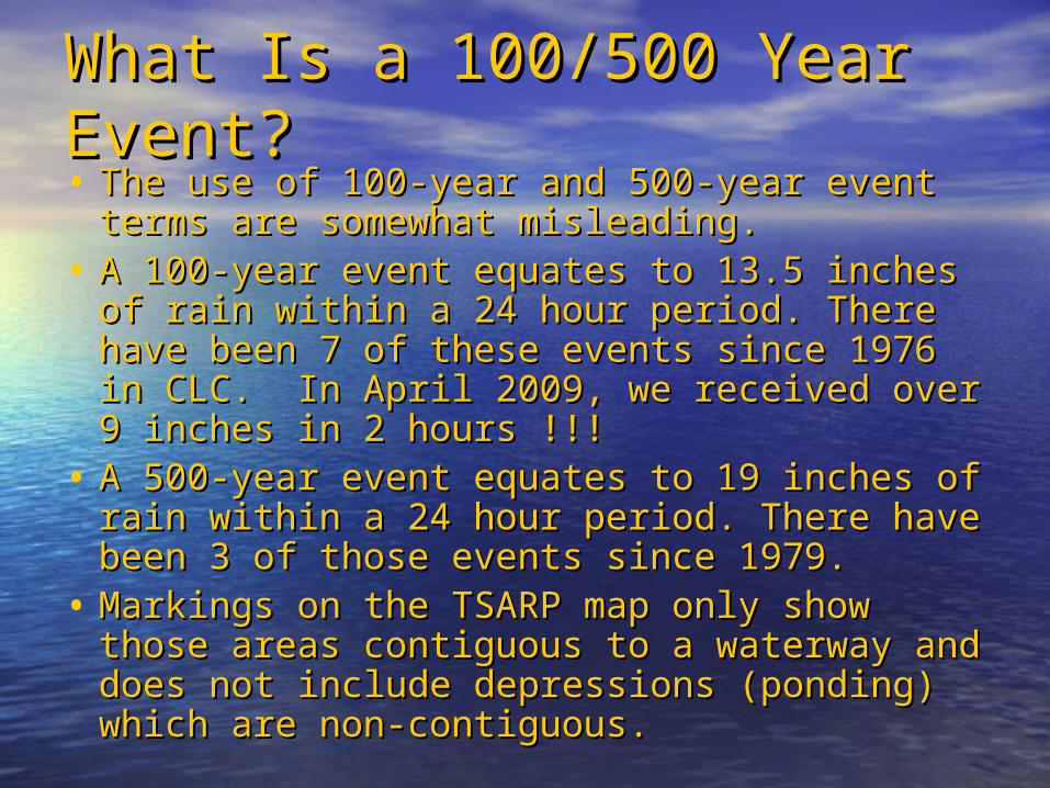
What Is a 100/500 Year What Is a 100/500 Year Event?Event?• The use of 100-year and 500-year event The use of 100-year and 500-year event
terms are somewhat misleading.terms are somewhat misleading.• A 100-year event equates to 13.5 inches of A 100-year event equates to 13.5 inches of
rain within a 24 hour period. There have been rain within a 24 hour period. There have been 7 of these events since 1976 in CLC. In April 7 of these events since 1976 in CLC. In April 2009, we received over 9 inches in 2 2009, we received over 9 inches in 2 hours !!!hours !!!
• A 500-year event equates to 19 inches of rain A 500-year event equates to 19 inches of rain within a 24 hour period. There have been 3 of within a 24 hour period. There have been 3 of those events since 1979.those events since 1979.
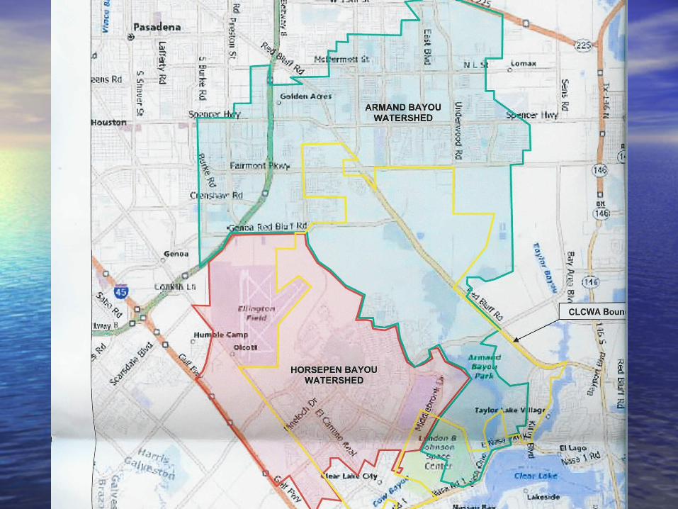
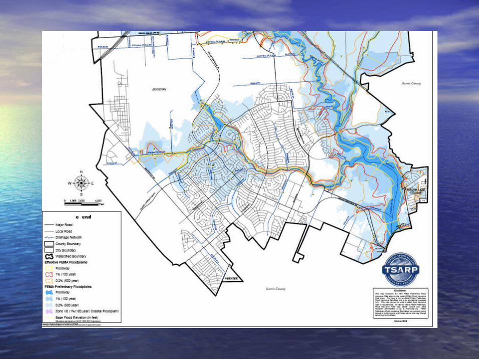
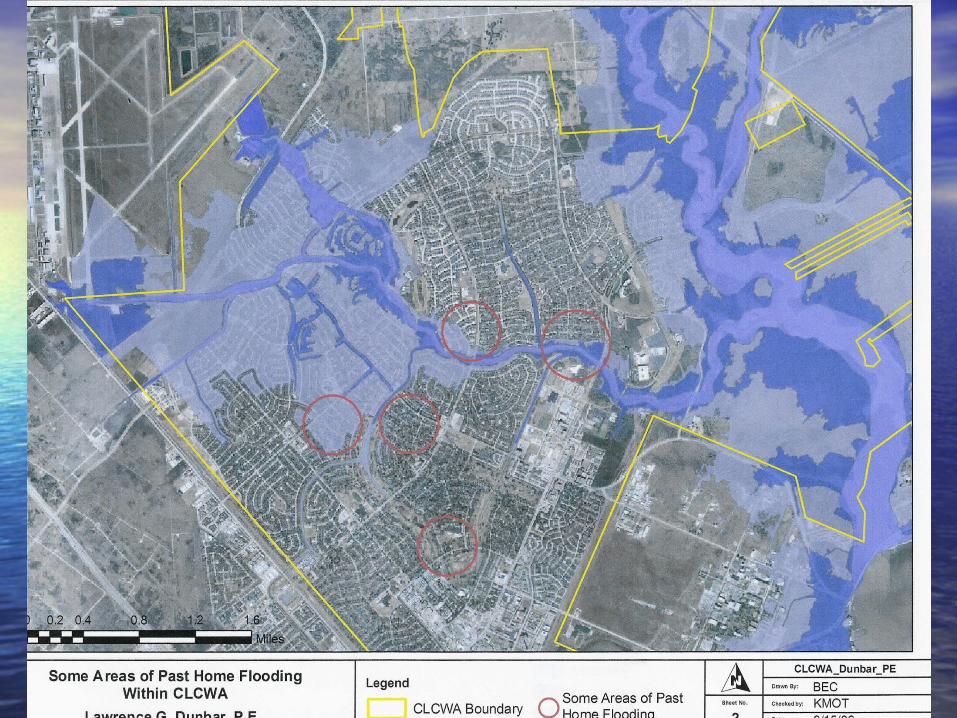
• Markings on the TSARP map only show those Markings on the TSARP map only show those areas contiguous to a waterway and does notareas contiguous to a waterway and does not include depressions (ponding) which are non-include depressions (ponding) which are non-contiguous.contiguous.
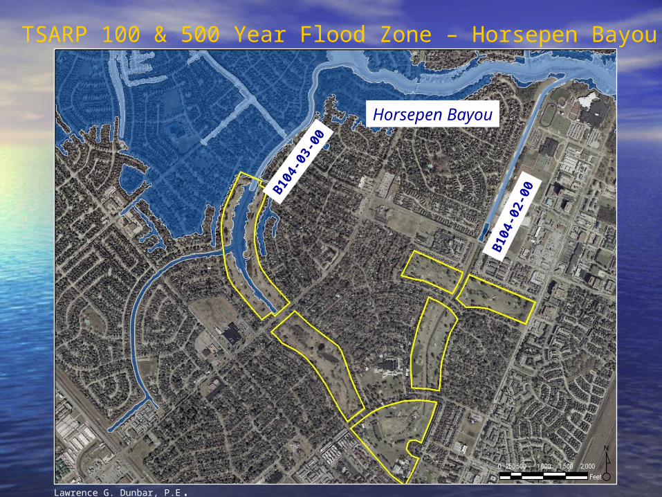
TSARP 100 & 500 Year Flood Zone – Horsepen Bayou
B104-
03-0
0
B104
-02-
00
Horsepen Bayou
Lawrence G. Dunbar, P.E. July, 2005
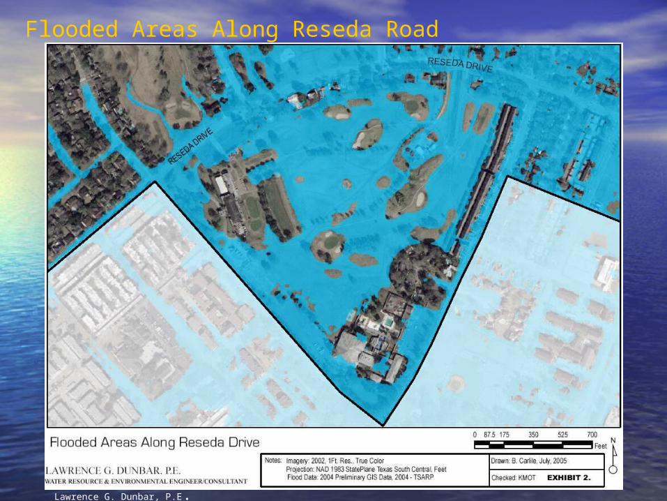
Flooded Areas Along Reseda Road
Lawrence G. Dunbar, P.E. July, 2005
CURRENT FLOODINGCURRENT FLOODING
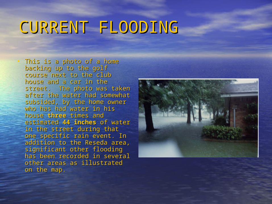
• This is a photo of a home This is a photo of a home backing up to the golf course backing up to the golf course next to the club house and a next to the club house and a car in the street. The photo car in the street. The photo was taken after the water had was taken after the water had somewhat subsided, by the somewhat subsided, by the home owner who has had home owner who has had water in his house water in his house threethree times and estimated times and estimated 4444 inchesinches of water in the street of water in the street during that one specific rain during that one specific rain event. In addition to the event. In addition to the Reseda area, significant other Reseda area, significant other flooding has been recorded in flooding has been recorded in several other areas as several other areas as illustrated on the map. illustrated on the map.
ApproachApproach
• Hired hydrology consultant to better understand floodingHired hydrology consultant to better understand flooding in our in our specific watershed and make recommendations on how to mitigate specific watershed and make recommendations on how to mitigate any future increase and reduce existing problems if possible.any future increase and reduce existing problems if possible.
LearningsLearnings• Flooding is a result of storm water run-off. Flooding increases as Flooding is a result of storm water run-off. Flooding increases as
development covers the ground with impervious surfaces and the development covers the ground with impervious surfaces and the ground can no longer soak up the rain.ground can no longer soak up the rain.
• Detention is now becoming recognized as the best method to control Detention is now becoming recognized as the best method to control flooding along the Texas Gulf Coast versus previous emphasis to flooding along the Texas Gulf Coast versus previous emphasis to make drainage waterways wider, deeper and straighter.make drainage waterways wider, deeper and straighter.
• Harris County Flood Control District developed their detention Harris County Flood Control District developed their detention requirements several decades ago based on the requirements several decades ago based on the averageaverage county county rainfall, soil types, elevations, etc. The Clear Lake area is significantly rainfall, soil types, elevations, etc. The Clear Lake area is significantly different in all these conditions than Northwest Harris County. HCFCD different in all these conditions than Northwest Harris County. HCFCD currently has their detention criteria under review.currently has their detention criteria under review.
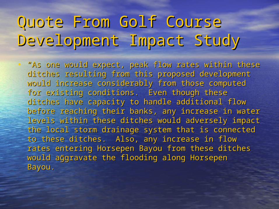
Quote From Golf Course Quote From Golf Course Development Impact StudyDevelopment Impact Study• ““As one would expect, peak flow rates within these ditches As one would expect, peak flow rates within these ditches
resulting from this proposed development would increase resulting from this proposed development would increase considerably from those computed for existing conditions. considerably from those computed for existing conditions. Even though these ditches have capacity to handle Even though these ditches have capacity to handle additional flow before reaching their banks, any increase in additional flow before reaching their banks, any increase in water levels within these ditches would adversely impact water levels within these ditches would adversely impact the local storm drainage system that is connected to these the local storm drainage system that is connected to these ditches. Also, any increase in flow rates entering Horsepen ditches. Also, any increase in flow rates entering Horsepen Bayou from these ditches would aggravate the flooding Bayou from these ditches would aggravate the flooding along Horsepen Bayou.”along Horsepen Bayou.”
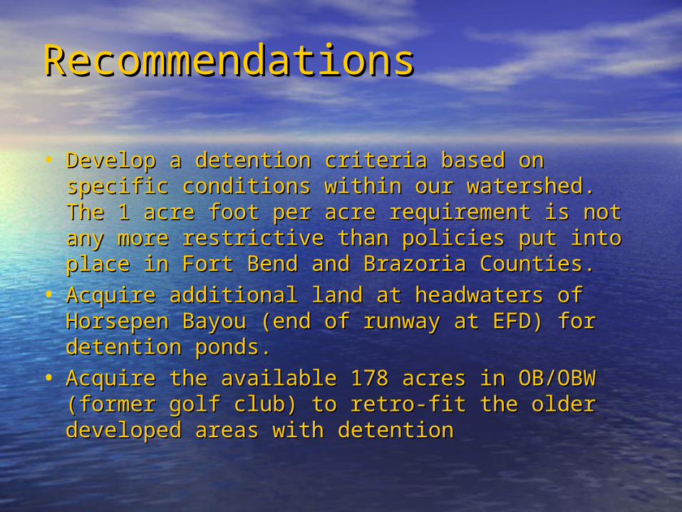
RecommendationsRecommendations
• Develop a detention criteria based on specific Develop a detention criteria based on specific conditions within our watershed. The 1 acre foot conditions within our watershed. The 1 acre foot per acre requirement is not any more restrictive per acre requirement is not any more restrictive than policies put into place in Fort Bend and than policies put into place in Fort Bend and Brazoria Counties.Brazoria Counties.
• Acquire additional land at headwaters of Acquire additional land at headwaters of Horsepen Bayou (end of runway at EFD) for Horsepen Bayou (end of runway at EFD) for detention ponds.detention ponds.
• Acquire the available 178 acres in OB/OBW Acquire the available 178 acres in OB/OBW (former golf club) to retro-fit the older developed (former golf club) to retro-fit the older developed areas withareas with detentiondetention
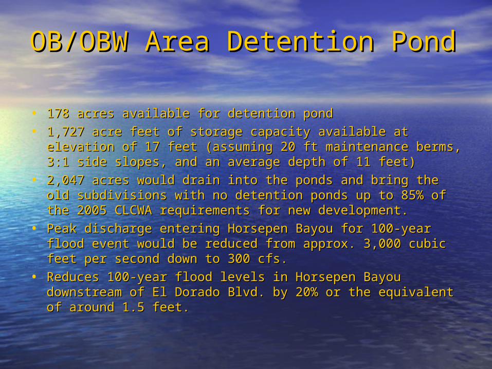
OB/OBW Area Detention PondOB/OBW Area Detention Pond
• 178 acres available for detention pond178 acres available for detention pond
• 1,727 acre feet of storage capacity available at elevation of 1,727 acre feet of storage capacity available at elevation of 17 feet (assuming 20 ft maintenance berms, 3:1 side 17 feet (assuming 20 ft maintenance berms, 3:1 side slopes, and an average depth of 11 feet)slopes, and an average depth of 11 feet)
• 2,047 acres would drain into the ponds and bring the old 2,047 acres would drain into the ponds and bring the old subdivisions with no detention ponds up to 85% of the 2005 subdivisions with no detention ponds up to 85% of the 2005 CLCWA requirements for new development.CLCWA requirements for new development.
• Peak discharge entering Horsepen Bayou for 100-year flood Peak discharge entering Horsepen Bayou for 100-year flood event would be reduced from approx. 3,000 cubic feet per event would be reduced from approx. 3,000 cubic feet per second down to 300 cfs.second down to 300 cfs.
• Reduces 100-year flood levels in Horsepen Bayou Reduces 100-year flood levels in Horsepen Bayou downstream of El Dorado Blvd. by 20% or the equivalent of downstream of El Dorado Blvd. by 20% or the equivalent of around 1.5 feet.around 1.5 feet.
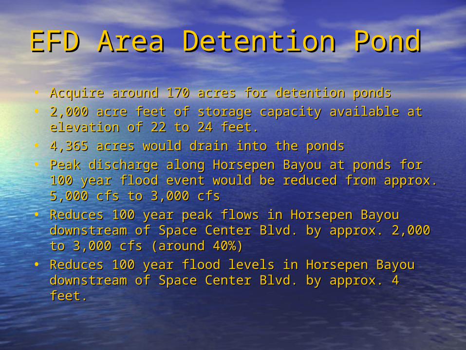
EFD Area Detention PondEFD Area Detention Pond
• Acquire around 170 acres for detention pondsAcquire around 170 acres for detention ponds
• 2,000 acre feet of storage capacity available at elevation of 2,000 acre feet of storage capacity available at elevation of 22 to 24 feet.22 to 24 feet.
• 4,365 acres would drain into the ponds4,365 acres would drain into the ponds
• Peak discharge along Horsepen Bayou at ponds for 100 Peak discharge along Horsepen Bayou at ponds for 100 year flood event would be reduced from approx. 5,000 cfs year flood event would be reduced from approx. 5,000 cfs to 3,000 cfsto 3,000 cfs
• Reduces 100 year peak flows in Horsepen Bayou Reduces 100 year peak flows in Horsepen Bayou downstream of Space Center Blvd. by approx. 2,000 to downstream of Space Center Blvd. by approx. 2,000 to 3,000 cfs (around 40%)3,000 cfs (around 40%)
• Reduces 100 year flood levels in Horsepen Bayou Reduces 100 year flood levels in Horsepen Bayou downstream of Space Center Blvd. by approx. 4 feet.downstream of Space Center Blvd. by approx. 4 feet.
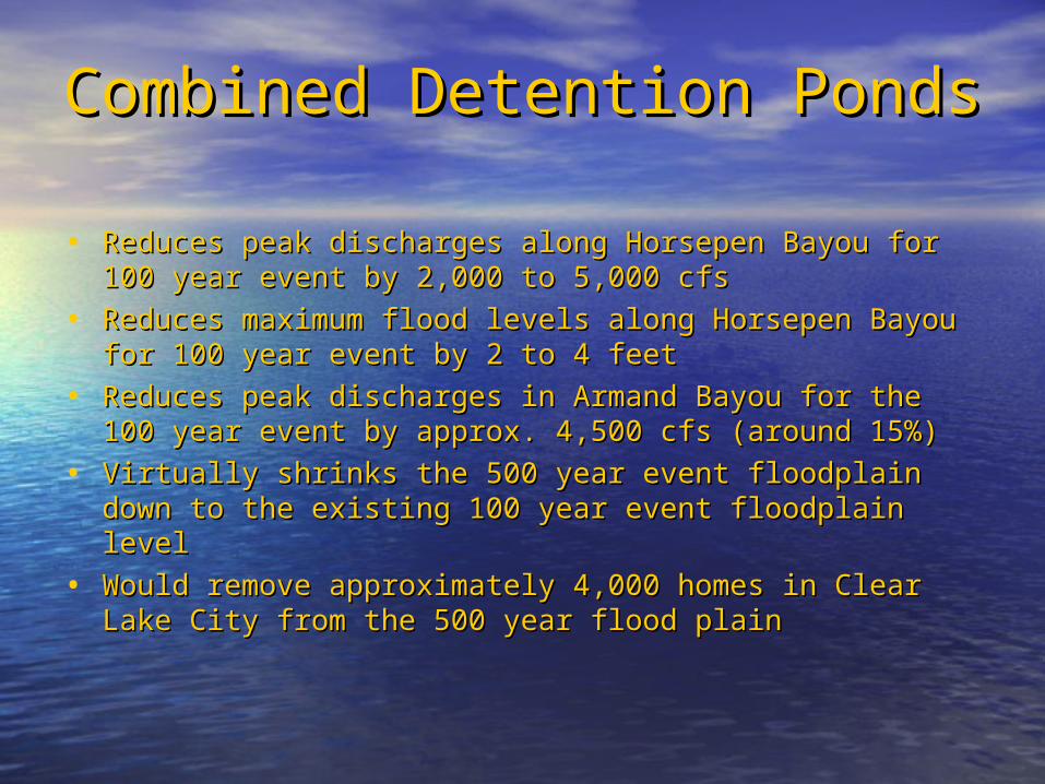
Combined Detention PondsCombined Detention Ponds
• Reduces peak discharges along Horsepen Bayou for 100 Reduces peak discharges along Horsepen Bayou for 100 year event by 2,000 to 5,000 cfsyear event by 2,000 to 5,000 cfs
• Reduces maximum flood levels along Horsepen Bayou for Reduces maximum flood levels along Horsepen Bayou for 100 year event by 2 to 4 feet100 year event by 2 to 4 feet
• Reduces peak discharges in Armand Bayou for the 100 year Reduces peak discharges in Armand Bayou for the 100 year event by approx. 4,500 cfs (around 15%)event by approx. 4,500 cfs (around 15%)
• Virtually shrinks the 500 year event floodplain down to the Virtually shrinks the 500 year event floodplain down to the existing 100 year event floodplain levelexisting 100 year event floodplain level
• Would remove approximately 4,000 homes in Clear Lake Would remove approximately 4,000 homes in Clear Lake City from the 500 year flood plainCity from the 500 year flood plain
Multi-use For Taxpayer Multi-use For Taxpayer ValueValue• Single use does not maximize Single use does not maximize
taxpayer valuetaxpayer value• Detention pond areas can be used Detention pond areas can be used
for a wide variety of recreational for a wide variety of recreational activitiesactivities
• Pledge to work jointly with County, Pledge to work jointly with County, City and local citizens to develop a City and local citizens to develop a plan for designing multi-use plan for designing multi-use amenities into the detention facilitiesamenities into the detention facilities
Status of RecommendationsStatus of Recommendations
• New storm water detention policy put into place in Nov. New storm water detention policy put into place in Nov. 2005 which applies to all new development2005 which applies to all new development
• Jury in state district court golf course condemnation court Jury in state district court golf course condemnation court hearing in November 2008 ruled that they believed that the hearing in November 2008 ruled that they believed that the condemnation was about blocking development and not condemnation was about blocking development and not storm water detention. Ruling has been appealed by the storm water detention. Ruling has been appealed by the CLCWA and is expected to be reviewed in Spring of 2010. CLCWA and is expected to be reviewed in Spring of 2010. Land value was set in the lower court at $5.1 million.Land value was set in the lower court at $5.1 million.
• EFD area ponds have been discussed with HCFCD and City EFD area ponds have been discussed with HCFCD and City of Houston. Since development in that area is not eminent, of Houston. Since development in that area is not eminent, concentration of efforts is centered on the OB/OBW concentration of efforts is centered on the OB/OBW property at this time. Will take the cooperation of Exxon property at this time. Will take the cooperation of Exxon Mobil, Harris County, and City of Houston to put into place.Mobil, Harris County, and City of Houston to put into place.
Storm Surge StudyStorm Surge Study
• CLCWA approached in Spring of 2009 by Rice University with a CLCWA approached in Spring of 2009 by Rice University with a proposal to conduct a storm surge study for the Clear Lake area.proposal to conduct a storm surge study for the Clear Lake area.
• Study would take studies already done on rainfall events and Study would take studies already done on rainfall events and overlay with various storm surge scenarios. Maps would show overlay with various storm surge scenarios. Maps would show actual water depth by address.actual water depth by address.
• Interactive map would be posted on web site so that residents Interactive map would be posted on web site so that residents could access and determine the impact on their home as part of could access and determine the impact on their home as part of their emergency planning.their emergency planning.
• Map would also be useful in emergency response planning with a Map would also be useful in emergency response planning with a better understanding of how deep water would be in streets.better understanding of how deep water would be in streets.
• Total cost would be $65,000. CLCWA agreed to fund half of the Total cost would be $65,000. CLCWA agreed to fund half of the cost and Houston Endowment will fund the other half – study to cost and Houston Endowment will fund the other half – study to be complete by May 2010.be complete by May 2010.
Impact Fee InstitutedImpact Fee Instituted
• Current sewer plant capacity has been committed Current sewer plant capacity has been committed and any future capacity due to new development and any future capacity due to new development will require that the sewer plant be expanded.will require that the sewer plant be expanded.
• Additional development along Space Center Blvd Additional development along Space Center Blvd would also require building an addition water tower would also require building an addition water tower to ensure adequate water pressure in the area.to ensure adequate water pressure in the area.
• In the Spring of 2009, the CLCWA implemented a In the Spring of 2009, the CLCWA implemented a new impact fee policy. Any new development new impact fee policy. Any new development would be required to pay a fee of around $3,000 would be required to pay a fee of around $3,000 per SFRE. These funds would be used to pay for per SFRE. These funds would be used to pay for any bond money required to expand the sewer any bond money required to expand the sewer plant and build new water towers.plant and build new water towers.
What Can Be Done NowWhat Can Be Done Now
• Continue to bring up the flooding issue to Continue to bring up the flooding issue to every every level of elected officials – CLCWA, level of elected officials – CLCWA, city, county, state, and federalcity, county, state, and federal
• Remember that the elevation increases to Remember that the elevation increases to the west – as they increase storm water the west – as they increase storm water run-off, where do you think it drains? All run-off, where do you think it drains? All areaarea governments need to work together.governments need to work together.
Thank YouThank You
For the opportunity to serve you and to For the opportunity to serve you and to explain how the CLCWA impacts the explain how the CLCWA impacts the quality of life in the Clear Lake areaquality of life in the Clear Lake area