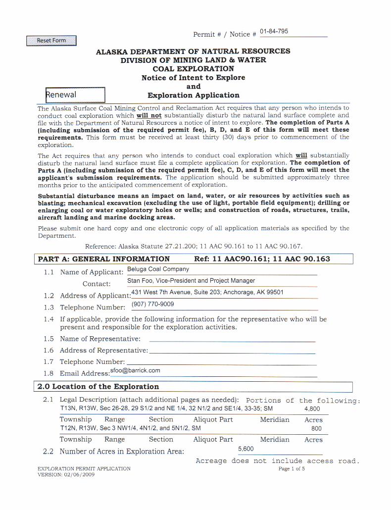
48
Coal Exploration Application Beluga Coal Company 431 West 7th Avenue; Suite 203 Anchorage, Alaska 99501 October 28, 2008

Coal Exploration Application
Beluga Coal Company 431 West 7th Avenue; Suite 203
Anchorage, Alaska 99501
October 28, 2008


Beluga Exploration Application - 1 - 10/28/08
Summary of the Application Beluga Coal Company, a subsidiary of Barrick Gold Company of North America, is applying to renew a coal exploration permit to drill up to 14 exploration wells in its Beluga coal leases. The wells would be drilled after freeze-up this fall (2008), and equipment would be demobilized before break-up next spring (2009). In that way, ground disturbance would be minimized or eliminated. No new roads would be constructed, though it may be necessary to cut some brush or maintain existing roads to the area. Roads and Transport. Equipment will be mobilized from Tyonek and possibly Shirleyville using existing pioneer roads that currently extend into the lease area. One of the main tracks from Shirleyville is a 100-foot public road easement, ADL 215335, originally reserved for timber sales in the Tyonek Area. It extends into T11N 13W, SM, and is managed by ADNR. This road and trails taking off from it have been periodically used for coal exploration, timber harvest, hunting, and general access since the 1970s or 1980s. These pioneer roads extend to the approximate location of the potential exploration camp. The pioneer road from Shirleyville appears useable without significant change except that in places brush adjacent to the road has grown up over the years and must be cut back for safe travel. No additional roads to the area will be constructed as a part of this permit, and brushing will be the minimum necessary to accommodate travel. The location of the route from Shirleyville to the site is shown in Figure 1 on the next page. Camp. This application assumes that temporary camp will be mobilized to the area (see Figure 1 for location). It is possible, however, that a low-snow year will allow the employees to commute to the lease area from Shirleyville. Assuming a camp is used, it will be set on blocks over the frozen ground and no significant ground clearing will be necessary. The camp would house approximately 10 people and use chemical or incinerating toilets. Graywater will be discharged consistent with DEC requirements. From the camp, drillers will access the 10-14 drill sites using low-ground-pressure vehicles over frozen ground. If there is only limited snow, it may be possible to access the drill locations by commuting from Shirleyville. The roads appear quite useable and able to accommodate wheeled or tracked vehicles without significant impediment up to the site, where low ground-pressure vehicles such as tracked or nodwell-type vehicles would be used. However, with significant snow a daily safe commute from Shirleyville would not be possible. The daily commute would be too long and required repeated snow removal and grading. If the project can operate without a camp, a shelter for emergency purposes will be constructed similar to the temporary camp in the permit area. The shelter would be used in case of equipment malfunction, medical emergency, or inclement weather. Drilling. Drilling will be by rotary drills from the surface to approximately the upper extent of the coal seam. Drilling through the seam will be by diamond core drills. The maximum depth will be approximately 350 feet. The drill will be a nominal 2.5-inch diameter, and drilling will involve placing approximately 2-inch PVC casing to the bottom of hole, with 6-inch protective steel casing within 5 feet of the surface.

Beluga Exploration Application - 2 - 10/28/08
The drill machinery consists of a single drill mounted on a low-ground-pressure vehicle that would be moved from location to location within the lease area. Drill platforms would be constructed over frozen ground with limited, if any, ground clearing. The purpose of the drilling is to remove a core sample of coal from target seams for testing and analysis. Because of the need to remove a core sample, existing holes cannot serve the function. The sample would be removed off site during exploration. To facilitate drilling, each drill site is twinned next to an existing hole so that the drillers can switch to coring equipment when before they hit the coal seam. Eleven of the drill sites are located on Figure 1. Three additional sites may be drilled, depending on the results of the first eleven. The additional sites will be located in the vicinity of the sites in Figure 1. Water Use. While the drill is working, it requires up to 6 gallons per minute, or up to 8,000 gallons per day. The drill should be at each site for 2-3 days, thus requiring up to approximately 25,000 gallons from a water source for each drill site. The water table is very close to the ground surface, and water appears to flow into any depression or hole. The project will try to use a pit adjacent to the drill platform to withdraw near-surface groundwater for the drill sites. The pit is expected to be approximately 12 square feet (4 feet by 3 feet), and three feet deep. During excavation the surface organic layer would be excavated from the remainder of the pit material. As the pit fills up with water, it will be pumped for the drill. After the drill site is finished, the pit would be filled with the piled material, and the surface organic layer placed back on top. These ground-water pits will be reclaimed as the drilling progresses. In the case that the pits do not provide adequate water, nine surface water sources have been identified (See Figure 1). Sources 1-7 are small marsh- streams that connect the pot-hole lakes together or connect to one of the larger streams in the area. The streams do not connect without significant blockage to any waterbody with anadromous or high-value resident fish. The sources were identified to avoid defined streams with a potential for significant fish habitat. Sources 8 and 9 are in the upper reaches of a tributary to Nikolai, significant above the blockage to anadromous fish. Source 9 would be used for the camp. The camp will require 400 gpd. The water would be taken from Source 9 in the upper reaches of a tributary to Nikolai Creek. Schedule. The exploration project — mobilizing, completing the drilling, and reclamation — is expected to require 4-6 weeks. This application requests permission to begin exploration as soon as freeze-up occurs: beginning no earlier than November 2008. Exploration activities for this year will end by April 2009, before break-up occurs. If the permit is approved in early enough this fall, drilling will occur from mid-November through the end of December or early January. However, drilling may also occur during March and April. In either case, the camp and drilling equipment will be removed prior to break-up. In addition to the exploration, monitoring groundwater wells by helicopter may continue after that time. For this reason, this application requests a two-year permit term to continue water quality monitoring through 2010.

Beluga Exploration Application - 3 - 10/28/08
Reclamation. Except for the ground water pits described previously in the section about water use, and the actual drill hole, no significant ground disturbance is expected under the exploration program. It is unlikely, though possible, that some grading may be required to flatten an area for the drill site. If so, any topsoil will be stockpiled, and during reclamation the topsoil and overburden will be replaced an appropriately contoured to mimic its origination configuration. It is also quite likely that no grading, except for the ground-water pits, will be required during the life of this exploration application. During reclamation the drill holes will be plugged consistent with regulation as explained elsewhere in this application. During reclamation, the PVC casing will remain. If possible, the steel casing will be removed. If the casing cannot be removed, it will be cut-off and at least the top one foot closest to the ground surface will be removed. Up to six wells will remain as monitoring wells. The remaining core holes drilled in this exploration program will be reclaimed before equipment is demobilized from the site. Currently, the Department of Natural Resources is holding a bond of $13,800. This bond is to reclaim 14 existing groundwater monitoring wells, and to fix a small amount of subsidence that occurred near a previously reclaimed test shaft. This application proposes to add an additional $11,336 for reclamation of the wells drilled for this project and in the unexpected event that ground disturbance requires seeding. Figures. The next three pages show maps of the lease and nearby area. Figure 1 shows the lease area, the eleven of the proposed drill holes (up to three others may be located in the vicinity of these based on the results of the first eleven drilled). It also shows the nine water sources, the camp area, and the transportation route to the site. Figure 2 is a larger-scale copy of Figure 1 focusing only on the exploration area. Figure 3 shows land status in the area.

Figure 1. Location of Drill Holes, Water Sources, and Transportation Routes
Beluga Exploration Application - 4 - 10/28/08

Beluga Exploration Application - 5 - 10/28/08
Figure 2. Close-up of Exploration Area

Beluga Exploration Application - 6 - 10/28/08
Figure 3. Land Status

Beluga Exploration Application - 7 - 10/28/08
History The Coal leases within the permit area were first issued in 1971. During the 1970s and early 1980s, exploration activities occurred including drilling exploration wells and excavation of a bulk sample. The Alaska Surface Coal Mining Control and Reclamation Act (ASCMCRA) was not passed unit the 1980s, and the first permit issued under the new law was Coal exploration permit 01-84-795. That permit has been renewed various times over the years, and is the subject of this renewal application. A partial history of that permit is below:
• Issued June 1985 through June 1987. It authorized “5 drill holes for hydrologic monitoring, 64 deep probe holes, 50 shallow probe holes and reclamation of an existing bulk sample pit.”
• Renewed March 1987 through February 1989 for up to 100 bore drill holes some of which would be used as groundwater monitoring wells. It was subsequently revised in 1988 to authorize the digging of a shaft and the removal of a 3 to 10-ton bulk coal sample.
• Renewed February 1993. • Renewed 2001 through January 2003. • Renewed July 2004 (presumably through July 2006). Authorized groundwater
monitoring from existing wells. In addition to the renewals indicated above, the various reclamation activities have occurred, and companies have maintained reclamation bond for unreclaimed activities (mostly groundwater monitoring wells) since the early 1980s.
Beluga Exploration Application - 8 - 10/28/08
Required Information This section provides information required by the ASCMCRA law and regulations. It follows the organization of the regulations: 11 AAC 90.163 and 167. The regulation is in italics, and the required information is in normal type-font below each regulation. 11 AAC 90.163 §163(a)(1) the information required under 11 AAC 90.161(a)(1), (a)(2), and (a)(5);
• §161(a)(1) the name, address and telephone number of the person seeking to explore and the person who will be present at and responsible for conducting the exploration activities;
Stan Foo, Vice-President and Project Manager Beluga Coal Company Barrick Gold Company of North America 431 West 7th Avenue; Suite 203 Anchorage, Alaska 99501 Tele: 907-770-9009 e-mail: [email protected]
• §161(a)(2) a statement of the period of intended operations;
This application requests permission to begin exploration as soon as freeze-up occurs: beginning no earlier than November 2008. Exploration activities for this year will end by April 2009, before break-up occurs. In addition, monitoring of groundwater wells by helicopter may continue after that time. This application requests a two-year permit term to continue water quality monitoring through 2010.
• §161(a)(5) an explanation of the right of the person seeking to explore to enter and
conduct exploration activities;
The applicant listed under §161(a)(1) is the Alaska representative of the coal leasee: (Beluga Coal Company; Barrick Gold Company of North America; 136 East south Temple 31300. Salt Lake City UT 84111).
§163(a)(2) an exploration and reclamation plan of operations that includes: • (a)(2)(A) a brief description of the proposed area, cross-referenced to the map required
under (4) of this section, including available information on the following: o surface topography; geologic, surface water, and other physical features;
The lease area, where the wells are to be drilled, consists mainly of the broad Beluga Plateau which is generally low to moderate relief. Streams have dissected the overburden and underlying sedimentary rock creating sharp valleys. The Chuitna River has cut a sharp canyon which varies from 200 to 300+ feet deep near the exploration area, a few unnamed tributaries of the Chuitna have cut

Beluga Exploration Application - 9 - 10/28/08
shallower canyons in the plateau as well. To the west, the lease area falls off steeply to Trading Bay State Game Refuge. The plateau slopes gently approximately to the southeast. Elevations in the lease area range from approximately 1,300 feet on the southeast edge to approximately 1,600 feet to on the upper northwest side. The main drainage for the site is the Chuitna River. Water discharge information based on two years of record indicates that downstream of tributary 2005 at the base of the lease area, the Chuitna has a mean flow of 200 cfs with daily flow varying from 27 to 2,940 cfs.1 This gaging station drains an area 70.5 square miles. It includes the flow from ungaged tributaries within the lease area including Stream 2005 (7.7 square mile drainage area), and an unnamed stream that merges with the Chuitna in section 27 (1 square mile drainage area). A minority of the area drains to either directly or through an unnamed tributary to Nikolai Creek. The level of the groundwater in the area is not precisely known. However, for most of the area, near-surface groundwater exists for most of the area and is expected within 20 feet of the surface. Based on previous experience, artesian conditions are not expected. The groundwater supplies pot-hole lakes throughout the site, many of which lack a defined outline and are unconnected to a stream.
o vegetative cover; The area includes significant bogs, small lakes and wetlands. From a 1983 reclamation analysis:2 “The understory and overstory strata in the area are comprised of black cottonwood, balsam poplar, paper birch, quaking aspen, and black, white, and Sitka spruce. The Cottonwood and poplar occur in both mixed stands and individually or together intermixed with black or white spruce along water courses. Species present in the woody shrub layer include: willow, alder, current, devil’s club, spruce blueberry, poplar, cottonwood, birch, aspen, rose, highbush cranberry, mountain-ask, elderberry, salmon berry spiraea, and shrubby cinquefoil. Willow and alder form moderate-to-dense thickets along water courses and on slopes and elevated areas between streams. Willow and current often occur in the ecotone between alder thickets and grassy meadows.” “Ground cover in the open areas without shrub, understory, or overstory layers can generally be grouped into three broad categories: - dominant: sphagnum, crowberry, glandular birch - dominant: sedges horsetail - dominant: grasses, fireweed, ferns”
1 Data taken from public information submitted by the Chuitna Coal Project; Hydrologic Component Baseline Report March 2007; Table 3-1 and 3-6; pages 3-3 and 3-22. 2 Lone Ridge Bulk Sample Site (Beluga) Reclamation Plan. Submitted to DNR Division of Minerals and Energy Management by Placer Amex, Inc. Prepared by Dowl Engineers. September 1983. Page 7-8.

Beluga Exploration Application - 10 - 10/28/08
“Ground cover associations in woody or shrubby areas tend to be similar to those noted above for open areas but much similar in composition.” Figure 4, below shows typical vegetation within the exploration area. Note that there are few trees. Most of the trees are lower in the lease area or along the water courses.
Figure 4. Typical Vegetation at a Drill Site
o fish, wildlife, and plants, including any endangered or threatened species listed under the Endangered Species Act of 1973, as amended (16 U.S.C. 1531 – 1543);
The 1983 Placer Amex application previously cited indicates that “Large mammals utilizing the area are principally moose and black bear, with a few brown bear along the upper water courses. Other mammals observed in the general [exploration] area…include the dusky shrew, arctic ground squirrel, red-backed and tundra voles, northern bog lemming, coyote, and shorttail weasel or ermine.”3 This information is consistent with the Kenai Area Plan (adopted 2000) for parcel 177 (which includes the lease area).
3 Ibid, page 8.

Beluga Exploration Application - 11 - 10/28/08
The Kenai Area Plans also indicates that “Most of the sport fishing on the Chuitna (Chuit) River occurs downstream from this unit.” (The area plan unit, parcel 177, begins significantly downstream of this lease area). According to the DF&G Fish Distribution Database Atlas, the Chuit River, downstream from the lease and exploration area, is used for all five species of Alaskan salmon plus Dolly Varden. Adjacent to the lease area, the Chuit is used for Coho and King Salmon spawning. Dolly Varden is also present in this location. Upstream of the mine, above the confluence of Wolverine Creek, the database shows only Coho Salmon rearing habitat. The only tributary in the lease area that shows fish presence is a tributary in the upper portions of the lease area, in Section 29 which shows Coho and King Salmon rearing habitat for approximately 1/3 of a mile. There are no upland threatened or endangered species within the exploration area.
• (a)(2)(B) a description of known cultural or historic resources listed or eligible for listing on the National Register of Historic Places and known archaeological features within the proposed exploration area. The commission will, in the commissioner’s discretion, require additional information regarding known or unknown historic or archaeological resources if these resources are likely to be affected by activities under this section;
Alaska’s historic database with the DNR Division of Parks, Office of Heritage and Archaeology shows no know cultural or historic resources within the lease area, nor along the roads to be used to gain access to the leases.
• (a)(2)(C) a description of the methods to be used to conduct coal exploration and
reclamation including, types and uses of equipment, drilling, blasting, road or other transportation facility construction, and earth and debris disposal areas;
The current drilling program is intended to recover coal core for off-site quality testing. The current plan calls for drilling during winter ground conditions (snow cover and frozen ground) using a diamond core drill mounted on a nodwell-type low ground pressure track type carrier. The core size anticipated is a nominal 2.5-inch diameter core, though the surface casing diameter may be up to 6 inches. Interval drilling between cores will be accomplished with a combination of coring and conventional rotary drilling. Hole depths are not expected to exceed 350’. Figures 1 and 2 show the general locations of the proposed drill holes. All holes will be drilled as “twin” holes to previously drilled holes from past programs. Highlights of the program include:
In total, 11 to 14 holes are planned for the 2008-2009 drill program. As described previously, access between holes and set up at each site is
not anticipated to require earth moving activities. Travel will be on top of the tundra and snow.
Access to and from the site exploration area will be via the existing trails shown in Figure 1. Only minor clearing would be needed on limited stretches of the existing roads.

Beluga Exploration Application - 12 - 10/28/08
Crews will be housed on site at a temporary camp setting centrally located on the Center Ridge area (see map). Camp will be established with minimal ground disturbance (no foundations other than cribbing).
For drill water, local ponds, small streams, or groundwater pits (described in the summary) will be utilized to draw the required drill water. Quantities are not anticipated to exceed 8,000 gallons per day.
No blasting or excavation is planned during this program period
• (a)(2)(D) an estimated timetable for each phase of exploration and reclamation;
Exploration is expected to require approximately six weeks beginning in early November. As described in the summary, a camp, if used, will be set up within the first few days, and then drilling will begin. The camp and drill sites will be disassembled and removed from the area once drilling is finished. If a permit is not approved until after early November, drilling will occur in March through mid-April, and the camp and drill sites will be disassembled and removed while the ground remains frozen. The exploration is being conducted during frozen-ground conditions to prevent significant ground disturbance in the lease area. In the event that ground disturbance unexpectedly occurs, any unexpected disturbance will be recontoured before equipment leaves. Drill holes will be reclaimed before equipment leaves the site. In the unexpected event that fertilizing (or planting, if necessary) is needed, it will occur after break-up but during 2009.
• (a)(2)(E) the estimated amounts of coal to be removed and a description of the methods
to be used to determine those amounts.
The only coal to be removed is a 2.5-inch core from each of the seams, in each of the drill holes.
• (a)(2)(F) the documentation required under (b) and (c) of this section if the applicant
proposes to remove more than 250 tons of coal; and
Not applicable. The applicant not proposing to remove more than 250 tons of coal.
• (a)(2)(G) a description of how the exploration activities will comply with 11 AAC 90.167.
See the section later in this application that provides the information required by 11 AAC 90.167.
§163(a)(3) the names and address of all owners and leaseholders of record of the surface land and the mineral estate in the area to be explored.

Beluga Exploration Application - 13 - 10/28/08
The land and mineral estate within the lease area is owned by the State of Alaska, managed by DNR, Division of Mining, Land and Water. Within the area to be explored the coal leaseholder is:
Beluga Coal Company Barrick Gold Company of North America 136 East south Temple 31300 Salt Lake City UT 84111.
There are no other land or mineral estate owners in the area where the exploration is planned.
The following landowners own land along the existing trail system from Shirleyville to the lease area.
• Alaska Mental Health Land Trust 718 L Street, Suite 202 Anchorage AK 99501
• Kenai Peninsula Borough
144 N. Binkley Soldotna, Alaska, 99669
The Tyonek Native Corporation also owns land along the road from the barge landing site at North Foreland to Shirleyville.
• Tyonek Native Corporation P O BOX 82090 Tyonek, Alaska (AK) 99682
And (alternate address)
1689 C Street, Suite #219 Anchorage, Alaska (AK) 99501
§163(a)(4) a map of the 1:63:360 scale series enlarged at least 2.5 times showing, based on available information, the area to be disturbed by the proposed exploration and reclamation activities, including existing roads, structures, pipelines, and the proposed location of trenches, roads, rights-of-way and other access routes, land excavations to be conducted, water or coal exploratory holes and wells to be drilled or altered, earth or debris disposal areas, bodies of water, historic, archeological and cultural features, topographic and drainages features, and the habitats of endangered or threatened species identified in (2)(a) of this section; and
See figure 1 and 2.
§163(a)(5) a statement as to whether coal exploration is proposed for an area designated unsuitable for mining under AS 27.21.260.
The area is not designated unsuitable for mining under AS 27.21.260. §163(b) and (c) Extraction of more than 250 tons of coal under an exploration permit…

Beluga Exploration Application - 14 - 10/28/08
These two subsections are not applicable. This application does not propose extracting more than 250 tons of coal.
§163(d) The commissioner’s determination under 11 AAC 90.002(b) must be made in writing. The commissioner shall base the determination on a demonstration by the applicant that includes the information required under (c) of this section and:
(1) evidence that sufficient coal reserves are available to demonstrate that the amount of coal to be removed is not the total reserve, but is a sampling of a larger reserve; and
The amount of coal being withdrawn from a 2-inch core is inconsequential relative to the size of the reserve. The reserve is demonstrated through the multiple other previously drilled holes in the lease area and through state publications on the Beluga deposit.
(2) an explanation of why other means of exploration are not adequate to determine the quality of the coal or the feasibility of developing a surface coal mining operation.
The method of retrieving the coal — winter drilling and removing equipment before the ground thaws — is the most environmentally benign method of gaining access to the coal. Few, if any, short- or long-term impacts are expected. There are no less intrusive alternatives for acquiring a small amount of coal distributed throughout the deposit.

Beluga Exploration Application - 15 - 10/28/08
11 AAC 90.167 §167(a) Coal exploration that substantially disturbs the land surface and associated reclamation operations must be conducted to minimize, to the extent practical, environmental damage. The operations must comply with this section; however, the commissioner will, in his or her discretion, waive certain requirements of this section upon a written finding that the requirement will be superseded by subsequent permitted operations. The commissioner will, in his or her discretion, impose additional performance standards to minimize environmental damage if the particular type of exploration activity requires them.
This section does not require specific information from the application. However, this application does not request waiver of any of the performance standards of this section.
§167(b) The commissioner will, in his or her discretion, require a performance bond. In determining the amount and conditions of the band and the criteria for bond release, the commissioner will consider the relevant provisions of 11 AAC 90.201 – 11 AAC 90.213 and will specify the bond amount, conditions, and release criteria in the decision under 11 AAC 90.165(e).
The Beluga Coal Company currently maintains a performance bond of $13,800 with the Department of Natural Resources to cover reclamation of 14 water-quality monitoring wells. This existing bond is to reclaim 14 existing groundwater monitoring wells, and to fix a small amount of subsidence that occurred near a previously reclaimed test shaft. Reclamation of the drill holes, and any associated disturbance completed under this application will require approximately two people and a back-hoe approximately two hours to reclaim each well. The project operating plan is to leave up to six wells for groundwater monitoring, and to reclaim the remaining wells at the conclusion of drilling, and before the project drills the subsequent well. Thus, the maximum number of wells to be left is actually 6 wells which would require or 12 hours or 1 day of work. To ensure that the remain wells are reclaimed, or to allow for any additional delay, the project is estimating two days of work at the site; plus allowing a day for mobilization, and a day for demobilization. Therefore, equipment and personnel cost are as below:
Item $/Hour Hours Cost
Crew Lead $ 54.00 32 $ 1,728 Operator $ 45.00 32 $ 1,440 Laborer $ 29.00 32 $ 928
Backhoe $ 125.00 32 $ 4,000
Subtotal: $8,096
As explained elsewhere in the report, the project does not expect to re-seed areas but (consistent with agency preference) leave areas stabilized for return of surrounding vegetation. Reseeding will occur only for small areas and only as necessary to control erosion, especially near streams. No significant disturbance is expected for areas that will require immediate revegetation to control erosion. However, an amount for seed is included as a contingency. Assuming an application rate of 400 lb/acre, and a price of
Beluga Exploration Application - 16 - 10/28/08
$0.40/lb, the seed cost for an acre would be $160/acre. We have included the cost for seed for a maximum of two acres, or $320.
Despite the inclusion of contingency in the time allowance and seed coverage described earlier, we are including standard contingency measures in the estimate: 8% for engineering; 10% for additional contingency; 12% for contractor overhead an 6% for project management: a total of 36% for contingency and overhead. The result is $11,446 as displayed below.
Equipment and personnel: $8,096 Seed $320
Subtotal: $8,416 36% for contingency and overhead: $3,030
Total: $11,446
§167(c) The applicant must utilize impact control measures, management techniques and monitoring methods to protect endangered of threatened species listed under the Endangered Species Act of 1973 (16 U.S.C. Sec 1531 et Seq.), and their critical habitats; species such as eagles, migratory birds or other animals protected by state or federal law, and their habitats; and habitats of unusually high value for fish and wildlife.
There are no threatened and endangered species in the exploration area. For most of the area where the camp will be and where drilling will occur, there are few trees, and each drill site is in a clearing. No winter habitats of unusually high value for wildlife have been identified in the drilling area. The drilling, transportation, or camp will not affect streams, fish habitats or fish populations.
§167(d) The applicant must protect any cultural resources or districts, sites, buildings, structures or objects listed on the National Register of Historic Places, except to the extent approved jointly by the commissioner and the agency with jurisdiction over the protected place.
Nothing in the exploration area is either listed or has been determined eligible for the National Register of Historic Places. [See also response to §163(a)(2)(B)].
§167(e) Construction of new roads, aircraft runways, and marine facilities must be limited to the minimum necessary for the approved exploration and reclamation activities. Travel must be confined to existing roads, trails, runways, and marine facilities when excessive damage to vegetation or rutting of the land surface could result.
No aircraft runways or marine facilities will be constructed. There are existing trails to the exploration area. New roads/trails will not be necessary, though some brush clearing may be required to widen the cleared area for the width of the equipment. Brush clearing will be the minimum necessary for the task. Once within the lease area, travel will be on frozen ground. No significant damage or rutting is expected.
§167(f) Existing roads, trails, runways, and marine facilities may be used under the following conditions: (1) All applicable federal, state, and local requirements must be met. (2) If the road, trail, runway or marine facility is significantly altered or its use contributes additional suspended solids to streamflow or runoff, (j) of this section applies to those portions of the

Beluga Exploration Application - 17 - 10/28/08
activity. (3) After exploration and reclamation activities are completed, the road, trail, runway, or marine facility must be restored to a condition equal to or better than the pre-exploration condition.
All applicable federal, state, and local requirements are met by this application. The application does not propose to significantly alter any of the roads/trails. Stream crossing on an existing trail after freeze-up will not contribute additional suspended solids to the stream.
§167(g) Roads, trails, runways, and marine facilities constructed or significantly altered for the exploration and reclamation activities must comply with 11 AAC 90.491 for design, construction, maintenance and removal. The commissioner will, in his or her discretion, require the use of rolligons and air-cushioned vehicles or winter roads when necessary to minimize environmental impacts.
No roads will be constructed or significantly altered. In addition, the application proposes winter-use of low-ground-pressure vehicles on frozen grounds to minimize environmental impacts as mentioned in the regulation.
§167(h) Excavations, artificial flat areas, or embankments created during exploration must be returned to the approximate original contour when no longer needed.
Groundwater pits will be excavated by segregating the surface organics from the underlying material. They will be reclaimed by filling in the pits with the surface organics on top. It is unlikely, though possible, that some grading may be required to flatten an area for the camp or drill site. If so, any topsoil or surface organics will be stockpiled, and during reclamation the organics will be placed on top of the replaced overburden and appropriately contoured to mimic its original configuration. It is also quite likely that no significant grading will be required during the life of this exploration application.
§167(i) Topsoil must be removed, stored, and redistributed on disturbed areas as necessary to assure successful revegetation.
See response to §167(h), above. §167(j) All disturbed areas must be reseeded or planted to the same seasonal characteristics of growth as the original vegetation. The vegetative cover must be capable of stabilizing the soil against erosion. Revegetation must be carried out in a manner that encourages prompt vegetative cover and recovery of productivity levels compatible with the approved post-exploration land use. If both the pre-exploration and post-exploration land use is intensive agriculture, planting of crops normally grown will meet the requirements of this section.
Generally, the company understands that agencies, particularly the Department of Fish and Game, requests that small areas not be seeded but rather left for natural re-vegetation of surrounding plants so that the vegetation returns to as natural a habitat as possible. Reseeding of grasses, even native grasses, is generally appropriate for small areas only as necessary to control erosion, especially near streams.

Beluga Exploration Application - 18 - 10/28/08
This application expects that, to the extent additional disturbance actually occurs, it will occur only to small areas with no significant potential of introducing erosion to streams. In this situation, the company proposes not to re-seed, but rather to use the preferred agency practices of natural succession. However, the company has included the cost of seed and spreading seed in its reclamation bond, should a steep area, or some other areas with potential for erosion be unexpectedly disturbed. In the unexpected situation where seeding is necessary, the seed mix will consist of 50% Boreal Fescue, 46% Annual Ryegrass, and 4% Tobin Rape Seed. The seed mix is appropriate for stabilizing erosion and has the advantage that it allows local plants to re-establish themselves.
§167(k) Except for small and temporary diversions of overland flow of water around new roads, runways, marine facilities, drill pads, and support facilities, no ephemeral, intermittent or perennial stream may be diverted. Overland flow must be diverted in a manner that prevents erosion and complies with all other applicable federal and state laws and regulations.
No ephemeral, intermittent or perennial stream will be diverted. Because the exploration will occur in the winter, there will be no need to divert overland flow.
§167(l) Each exploration hole, borehole, well, or other exposed underground opening must comply with 11 AAC 90.303 – 11 AAC90.305.
Upon completion of a drill hole to be abandoned, the drill crews will backfill the hole with the driest available cuttings. All cuttings on the surface will be placed back into the drill hole. Unless otherwise granted by DNR, each coal-bearing unit will be sealed with a bentonite slurry: 20% bentonite, 20% cement, and 40% cuttings.4 Once the backfill material is within 10 feet of the surface, the remainder of the hole will be filled with 60% of the driest available drill cuttings and 40% granulated or powdered bentonite. The top one foot will be filled with a higher percentage of bentonite. The area immediately surrounding the drill hole will be mounded to promote run-off away from the drill collar.
In the event that there are inadequate drill cuttings, the project will obtain fine-grained material from adjacent to the drill site. The project will scrape away organic top layer; use the fine-grained sediment, smooth the small barrow pit to blend into the landscape, and finally replace the organic material on top. With respect to seeding the area, see answer to §167(j) on page 17 of the application. If seeding does become necessary for a reason that is not currently known, we will use the seed mix referenced in answer to question 5.
Where holes are to be used for monitoring wells or piezometers, threaded PVC with well screen will be placed in the hole. The well construction will generally include a sand filter placed between the well screen and the borehole wall within the aquifer to be tested. A 3’ minimum bentonite plug will be placed on top of the well screen filter. The
4 This application is requesting that the project use 50% bentonite, and 50% cuttings. Cement contracts and cracks during the drying process, and the project understands that a 50% bentonite slurry will make form a more-effective seal. The project, however, will use the 20/20/60 mixtures unless otherwise approved.

Beluga Exploration Application - 19 - 10/28/08
remainder of the borehole will be backfilled with the driest available drill cuttings. The top plug will be constructed with the same methods used for abandon boreholes. The surface will include a minimum 2’ of PVC “stick-up” above the existing ground surface. A cap will be placed on top of the PVC to protect the well or piezometer from potential contamination by runoff. The relevant MSDS Sheets for drilling fluids that may be used at the site are attached. The products names are: Dextrid, EZ Mud Plus, FEB Hyseal No. 1, Drispac Polymer, and Quick Seal.
§167(m) all facilities and equipment must be removed when no longer needed, unless the commissioner approves retention for a specified period to (1) provide additional environmental quality data; (2) reduce or control the on- and off-site effects of the activities; (3) facilitate future operations under an approved permit or exploration approval.
All equipment and facilities will be removed this winter with the exception of piezometers to monitor environmental data.
§167(n) Exploration and reclamation must minimize disturbance to the prevailing hydrologic balancing, including , if necessary, sedimentation control measures that comply with 11 AAC 90.329 and 11 AAC 90.331 or other measures required by the commissioner.
Neither the exploration camp nor drill sites are near streams. Transportation is on existing roads or on frozen ground with low-pressure vehicles. These activities will not affect the prevailing hydrologic balance nor disturb areas such that any sediment control is necessary.
§167(o) Known acid-forming or toxic forming materials must be handled and disposed of in compliance with 11 AAC 90.335 and 11 AAC 90.445 or other measures required by t he commissioner.
No acid-forming or toxic materials will be handled or disposed of. None of the soil, overburden or coal is acid-forming or toxic. In any case, the coal cores will be transported off-site.
§167(p) The person conducting exploration activities must have available for review on-site the approval granted under 11 AAC 90.165.
No information requested.

Beluga Exploration Application - 20 - 10/28/08
Attachment: MSDS Sheets for Potential Drilling Fluids

MATERIAL SAFETY DATA SHEET Product Trade Name: DEXTRID® Revision Date: 02-Jun-20071. CHEMICAL PRODUCT AND COMPANY IDENTIFICATION
Product Trade Name: DEXTRID®Synonyms: NoneChemical Family: Modified StarchApplication: Fluid Loss Additive
Not for use in the United States Manufacturer/Supplier Baroid Fluid Services
Product Service Line of HalliburtonP.O. Box 1675Houston, TX 77251Telephone: (281) 871-4000Emergency Telephone: (281) 575-5000
Prepared By Chemical Compliance
Telephone: 1-580-251-4335e-mail: [email protected]
2. COMPOSITION/INFORMATION ON INGREDIENTS
SUBSTANCE CAS Number PERCENT ACGIH TLV-TWA OSHA PEL-TWAParaformaldehyde 30525-89-4 1 - 5% Not applicable Not applicableComplex carbohydrate 60 - 100% 10 mg/m3 15 mg/m3
3. HAZARDS IDENTIFICATION Hazard Overview May cause eye, skin, and respiratory irritation. May cause allergic skin and
respiratory reaction. Airborne dust may be explosive. 4. FIRST AID MEASURES
Inhalation If inhaled, remove to fresh air. If not breathing give artificial respiration, preferablymouth-to-mouth. If breathing is difficult give oxygen. Get medical attention.
Skin In case of contact, immediately flush skin with plenty of soap and water for at least 15
minutes. Get medical attention. Eyes In case of contact, or suspected contact, immediately flush eyes with plenty of water
for at least 15 minutes and get medical attention immediately after flushing. Ingestion Do not induce vomiting. Slowly dilute with 1-2 glasses of water or milk and seek
medical attention. Never give anything by mouth to an unconscious person. Notes to Physician Not Applicable
DEXTRID®Page 1 of 6

5. FIRE FIGHTING MEASURES
Flash Point/Range (F): Not DeterminedFlash Point/Range (C): Not DeterminedFlash Point Method: Not DeterminedAutoignition Temperature (F): Not DeterminedAutoignition Temperature (C): Not DeterminedFlammability Limits in Air - Lower (%): Not DeterminedFlammability Limits in Air - Upper (%): Not Determined
Fire Extinguishing Media Water fog, carbon dioxide, foam, dry chemical. Special Exposure Hazards Organic dust in the presence of an ignition source can be explosive in high
concentrations. Good housekeeping practices are required to minimize thispotential. Decomposition in fire may produce toxic gases.
Special Protective Equipment forFire-Fighters
Full protective clothing and approved self-contained breathing apparatus required forfire fighting personnel.
NFPA Ratings: Health 2, Flammability 1, Reactivity 0HMIS Ratings: Flammability 1, Reactivity 0, Health 2 6. ACCIDENTAL RELEASE MEASURES
Personal Precautionary MeasuresUse appropriate protective equipment. Avoid creating and breathing dust. Environmental PrecautionaryMeasures
Prevent from entering sewers, waterways, or low areas.
Procedure for Cleaning /Absorption
Scoop up and remove.
7. HANDLING AND STORAGE
Handling Precautions Avoid contact with eyes, skin, or clothing. Avoid creating or inhaling dust. Avoid dustaccumulations.
Storage Information Store away from oxidizers. Store in a dry location. Product has a shelf life of 12
months. 8. EXPOSURE CONTROLS/PERSONAL PROTECTION
Engineering Controls Use in a well ventilated area. Respiratory Protection Dust/mist respirator. (95%) Hand Protection Impervious rubber gloves. Skin Protection Normal work coveralls. Eye Protection Dust proof goggles. Other Precautions Eyewash fountains and safety showers must be easily accessible. 9. PHYSICAL AND CHEMICAL PROPERTIES
Physical State: Powder
Color: Off whiteOdor: Pungent
DEXTRID®Page 2 of 6

9. PHYSICAL AND CHEMICAL PROPERTIESpH: Not DeterminedSpecific Gravity @ 20 C (Water=1): 1.5Density @ 20 C (lbs./gallon): Not DeterminedBulk Density @ 20 C (lbs/ft3): 30-44Boiling Point/Range (F): Not DeterminedBoiling Point/Range (C): Not DeterminedFreezing Point/Range (F): Not DeterminedFreezing Point/Range (C): Not DeterminedVapor Pressure @ 20 C (mmHg): Not DeterminedVapor Density (Air=1): Not DeterminedPercent Volatiles: Not DeterminedEvaporation Rate (Butyl Acetate=1): Not DeterminedSolubility in Water (g/100ml): Partially solubleSolubility in Solvents (g/100ml): Not DeterminedVOCs (lbs./gallon): Not DeterminedViscosity, Dynamic @ 20 C (centipoise): Not DeterminedViscosity, Kinematic @ 20 C (centistrokes): Not DeterminedPartition Coefficient/n-Octanol/Water: Not DeterminedMolecular Weight (g/mole): Not Determined 10. STABILITY AND REACTIVITY
Stability Data: Stable Hazardous Polymerization: Will Not Occur Conditions to Avoid None known.
Incompatibility (Materials toAvoid)
Strong oxidizers. Strong acids. Strong alkalis. Amines.
Hazardous DecompositionProducts
Formaldehyde. Carbon monoxide and carbon dioxide.
Additional Guidelines Not Applicable 11. TOXICOLOGICAL INFORMATION
Principle Route of Exposure Eye or skin contact, inhalation. Inhalation Causes severe respiratory irritation. May cause allergic respiratory reaction. Skin Contact May cause a rash and itching of the skin. May cause severe skin irritation. This
product contains ingredients which may produce an allergic skin reaction. It shouldbe treated as a skin sensitizer.
Eye Contact May cause severe eye irritation. Ingestion Causes burns of the mouth, throat and stomach. Aggravated Medical Conditions Skin disorders. Eye ailments. Lung disorders. Chronic Effects/Carcinogenicity Paraformaldehyde may release formaldehyde monomer, a probable human
carcinogen. Chronic exposures may cause cancer of the lung and nasal passages.Formaldehyde and possibly paraformaldehyde may react with hydrochloric acid toform bis-chloromethyl ether, a known human carcinogen.
Other Information None known. Toxicity Tests
DEXTRID®Page 3 of 6

Oral Toxicity: LD50: 800 mg/kg (Rat) Dermal Toxicity: Not determined Inhalation Toxicity: Not determined Primary Irritation Effect: Not determined Carcinogenicity Not determined Genotoxicity: Not determined Reproductive /
Developmental Toxicity:Not determined
12. ECOLOGICAL INFORMATION
Mobility (Water/Soil/Air) Not determined Persistence/Degradability Not determined
Bio-accumulation Not Determined
Ecotoxicological Information
Acute Fish Toxicity: TLM96: 360 ppm (Oncorhynchus mykiss) Acute Crustaceans Toxicity:TLM96: 538,900 ppm (Mysidopsis bahia) SPP @ 10 ppb Acute Algae Toxicity: Not determined Chemical Fate Information Not determined Other Information Not applicable 13. DISPOSAL CONSIDERATIONS
Disposal Method Disposal should be made in accordance with federal, state, and local regulations. Contaminated Packaging Follow all applicable national or local regulations. 14. TRANSPORT INFORMATION
Land Transportation
DOTNot restricted
Canadian TDGNot restricted
ADR Not restricted
Air Transportation ICAO/IATA Not restricted
Sea Transportation IMDG Not restricted
DEXTRID®Page 4 of 6

Other Shipping Information Labels: None 15. REGULATORY INFORMATION
US Regulations US TSCA Inventory All components listed on inventory. EPA SARA Title III ExtremelyHazardous Substances
Not applicable
EPA SARA (311,312) HazardClass
Acute Health HazardChronic Health Hazard
EPA SARA (313) Chemicals This product does not contain a toxic chemical for routine annual "Toxic Chemical
Release Reporting" under Section 313 (40 CFR 372). EPA CERCLA/SuperfundReportable Spill Quantity
EPA Reportable Spill Quantity is 25000 Pounds based on Paraformaldehyde (CAS:30525-89-4).
EPA RCRA Hazardous WasteClassification
If product becomes a waste, it does NOT meet the criteria of a hazardous waste asdefined by the US EPA.
California Proposition 65 All components listed do not apply to the California Proposition 65 Regulation. MA Right-to-Know Law One or more components listed. NJ Right-to-Know Law One or more components listed. PA Right-to-Know Law One or more components listed. Canadian Regulations Canadian DSL Inventory All components listed on inventory. WHMIS Hazard Class D2B Toxic Materials
16. OTHER INFORMATION
The following sections have been revised since the last issue of this MSDSNot applicable Additional Information For additional information on the use of this product, contact your local Halliburton
representative.
For questions about the Material Safety Data Sheet for this or other Halliburtonproducts, contact Chemical Compliance at 1-580-251-4335.
Disclaimer Statement This information is furnished without warranty, expressed or implied, as to accuracy
or completeness. The information is obtained from various sources including themanufacturer and other third party sources. The information may not be valid underall conditions nor if this material is used in combination with other materials or in anyprocess. Final determination of suitability of any material is the sole responsibility ofthe user.
DEXTRID®Page 5 of 6

***END OF MSDS***
DEXTRID®Page 6 of 6

MATERIAL SAFETY DATA SHEETProduct Trade Name: EZ-MUD® PLUSRevision Date: 03-Jan-20081. CHEMICAL PRODUCT AND COMPANY IDENTIFICATION
Product Trade Name: EZ-MUD® PLUSSynonyms: NoneChemical Family: BlendApplication: Additive
Manufacturer/Supplier Baroid Fluid ServicesProduct Service Line of HalliburtonP.O. Box 1675Houston, TX 77251Telephone: (281) 871-4000Emergency Telephone: (281) 575-5000
Prepared By Chemical ComplianceTelephone: 1-580-251-4335e-mail: [email protected]
2. COMPOSITION/INFORMATION ON INGREDIENTS
SUBSTANCE CAS Number PERCENT ACGIH TLV-TWA OSHA PEL-TWAHydrotreated light petroleumdistillate
64742-47-8 10 - 30% 200 mg/m3 Not applicable
3. HAZARDS IDENTIFICATION
Hazard Overview May cause eye, skin, and respiratory irritation. May cause headache, dizziness, andother central nervous system effects. May be harmful if swallowed.
4. FIRST AID MEASURES
Inhalation If inhaled, remove to fresh air. If not breathing give artificial respiration, preferablymouth-to-mouth. If breathing is difficult give oxygen. Get medical attention.
Skin Wash with soap and water. Get medical attention if irritation persists. Removecontaminated shoes and discard.
Eyes In case of contact, immediately flush eyes with plenty of water for at least 15 minutesand get medical attention if irritation persists.
Ingestion Get medical attention! If vomiting occurs, keep head lower than hips to preventaspiration.
Notes to Physician Not Applicable
EZ-MUD® PLUSPage 1 of 6

5. FIRE FIGHTING MEASURES
Flash Point/Range (F): Not DeterminedMin: > 200Flash Point/Range (C): Not DeterminedMin: > 93Flash Point Method: PMCCAutoignition Temperature (F): Not DeterminedAutoignition Temperature (C): Not DeterminedFlammability Limits in Air - Lower (%): Not DeterminedFlammability Limits in Air - Upper (%): Not Determined
Fire Extinguishing Media Water fog, carbon dioxide, foam, dry chemical.
Special Exposure Hazards Decomposition in fire may produce toxic gases. Use water spray to cool fire exposedsurfaces.
Special Protective Equipment forFire-Fighters
Full protective clothing and approved self-contained breathing apparatus required forfire fighting personnel.
NFPA Ratings: Health 2, Flammability 1, Reactivity 0HMIS Ratings: Flammability 1, Reactivity 0, Health 2
6. ACCIDENTAL RELEASE MEASURES
Personal Precautionary MeasuresUse appropriate protective equipment.
Environmental PrecautionaryMeasures
Prevent from entering sewers, waterways, or low areas.
Procedure for Cleaning /Absorption
Isolate spill and stop leak where safe. Contain spill with sand or other inert materials.Scoop up and remove.
7. HANDLING AND STORAGE
Handling Precautions Avoid contact with eyes, skin, or clothing. Avoid breathing vapors. Wash hands afteruse. Launder contaminated clothing before reuse.
Storage Information Store away from oxidizers. Keep container closed when not in use. Product has ashelf life of 12 months.
8. EXPOSURE CONTROLS/PERSONAL PROTECTION
Engineering Controls A well ventilated area to control dust levels. Local exhaust ventilation should be usedin areas without good cross ventilation.
Respiratory Protection Organic vapor respirator with a dust/mist filter.
Hand Protection Impervious rubber gloves.
Skin Protection Rubber apron.
Eye Protection Chemical goggles; also wear a face shield if splashing hazard exists.
Other Precautions Eyewash fountains and safety showers must be easily accessible.
9. PHYSICAL AND CHEMICAL PROPERTIES
Physical State: LiquidColor: White to grayOdor: Mild hydrocarbon
EZ-MUD® PLUSPage 2 of 6

9. PHYSICAL AND CHEMICAL PROPERTIESpH: Not DeterminedSpecific Gravity @ 20 C (Water=1): 1.0Density @ 20 C (lbs./gallon): 8.3Bulk Density @ 20 C (lbs/ft3): Not DeterminedBoiling Point/Range (F): 347Boiling Point/Range (C): 175Freezing Point/Range (F): Not DeterminedFreezing Point/Range (C): Not DeterminedVapor Pressure @ 20 C (mmHg): Not DeterminedVapor Density (Air=1): Not DeterminedPercent Volatiles: 70Evaporation Rate (Butyl Acetate=1): < 1Solubility in Water (g/100ml): Partially solubleSolubility in Solvents (g/100ml): Not DeterminedVOCs (lbs./gallon): Not DeterminedViscosity, Dynamic @ 20 C (centipoise): Not DeterminedViscosity, Kinematic @ 20 C (centistrokes): Not DeterminedPartition Coefficient/n-Octanol/Water: Not DeterminedMolecular Weight (g/mole): Not Determined
10. STABILITY AND REACTIVITY
Stability Data: Stable
Hazardous Polymerization: Will Not Occur
Conditions to Avoid Keep away from heat, sparks and flame.
Incompatibility (Materials toAvoid)
Strong oxidizers.
Hazardous DecompositionProducts
Ammonia. Oxides of nitrogen. Carbon monoxide and carbon dioxide.
Additional Guidelines Not Applicable
11. TOXICOLOGICAL INFORMATION
Principle Route of Exposure Eye or skin contact, inhalation.
Inhalation May cause respiratory irritation. May cause central nervous system depressionincluding headache, dizziness, drowsiness, incoordination, slowed reaction time,slurred speech, giddiness and unconsciousness.
Skin Contact May cause skin irritation.
Eye Contact May cause eye irritation.
Ingestion Aspiration into the lungs may cause chemical pneumonitis including coughing,difficulty breathing, wheezing, coughing up blood and pneumonia, which can be fatal.May cause central nervous system depression including headache, dizziness,drowsiness, muscular weakness, incoordination, slowed reaction time, fatigueblurred vision, slurred speech, giddiness, tremors and convulsions.
Aggravated Medical Conditions Lung disorders.
Chronic Effects/Carcinogenicity No data available to indicate product or components present at greater than 1% arechronic health hazards.
EZ-MUD® PLUSPage 3 of 6

Other Information None known.
Toxicity Tests
Oral Toxicity: Not determined
Dermal Toxicity: Not determined
Inhalation Toxicity: Not determined
Primary Irritation Effect: Not determined
Carcinogenicity Not determined
Genotoxicity: Not determined
Reproductive /Developmental Toxicity:
Not determined
12. ECOLOGICAL INFORMATION
Mobility (Water/Soil/Air) Not determined
Persistence/Degradability Not determined
Bio-accumulation Not Determined
Ecotoxicological Information
Acute Fish Toxicity: Not determinedAcute Crustaceans Toxicity:TLM48: 98 mg/l (Acartia tonsa)Acute Algae Toxicity: EC50: 16.70 mg/l (Skeletonema costatum)
Chemical Fate Information Not determined
Other Information Not applicable
13. DISPOSAL CONSIDERATIONS
Disposal Method Disposal should be made in accordance with federal, state, and local regulations.
Contaminated Packaging Follow all applicable national or local regulations.
14. TRANSPORT INFORMATION
Land Transportation
DOTNot restricted
Canadian TDGNot restricted
ADR Not restricted
Air Transportation
EZ-MUD® PLUSPage 4 of 6

ICAO/IATA Not restricted
Sea Transportation
IMDG Not restricted
Other Shipping Information
Labels: None
15. REGULATORY INFORMATION
US Regulations
US TSCA Inventory All components listed on inventory.
EPA SARA Title III ExtremelyHazardous Substances
Not applicable
EPA SARA (311,312) HazardClass
Acute Health Hazard
EPA SARA (313) Chemicals This product does not contain a toxic chemical for routine annual "Toxic ChemicalRelease Reporting" under Section 313 (40 CFR 372).
EPA CERCLA/SuperfundReportable Spill Quantity
Not applicable.
EPA RCRA Hazardous WasteClassification
If product becomes a waste, it does NOT meet the criteria of a hazardous waste asdefined by the US EPA.
California Proposition 65 All components listed do not apply to the California Proposition 65 Regulation.
MA Right-to-Know Law Does not apply.
NJ Right-to-Know Law Does not apply.
PA Right-to-Know Law Does not apply.
Canadian Regulations
Canadian DSL Inventory All components listed on inventory.
WHMIS Hazard Class D2B Toxic Materials
16. OTHER INFORMATION
The following sections have been revised since the last issue of this MSDSNot applicable
Additional Information For additional information on the use of this product, contact your local Halliburtonrepresentative.
For questions about the Material Safety Data Sheet for this or other Halliburtonproducts, contact Chemical Compliance at 1-580-251-4335.
EZ-MUD® PLUSPage 5 of 6

Disclaimer Statement This information is furnished without warranty, expressed or implied, as to accuracyor completeness. The information is obtained from various sources including themanufacturer and other third party sources. The information may not be valid underall conditions nor if this material is used in combination with other materials or in anyprocess. Final determination of suitability of any material is the sole responsibility ofthe user.
***END OF MSDS***
EZ-MUD® PLUSPage 6 of 6

REVISION DATE: 22/09/06
SAFETY DATA SHEET
FEB Hyseal No.1
1 IDENTIFICATION OF THE SUBSTANCE/PREPARATION AND COMPANY/UNDERTAKING
PRODUCT NAME FEB Hyseal No.1
PRODUCT NO. 118338
BASF Construction Chemicals UK
Limited
SUPPLIER
Albany House
Swinton Hall Road
Swinton
Manchester
M274DT
+44(0)161 794 7411
CONTACT PERSON EHSQ Officer
EMERGENCY TELEPHONE Telephone: 0161 794 7411. If outside normal working hours, please listen to answer machine message
for emergency contact numbers.
2 COMPOSITION/INFORMATION ON INGREDIENTS
EC No.Name ClassificationCAS-No. Content
266-043-4Portland Cement Xi;R38,R41.65997-15-1 30-60%
The Full Text for all R-Phrases are Displayed in Section 16
COMPOSITION COMMENTS
Modified sand - cement mixture
3 HAZARDS IDENTIFICATION
Irritating to skin. Risk of serious damage to eyes.
CLASSIFICATION Xi;R38, R41.
4 FIRST-AID MEASURES
GENERAL INFORMATION
This product contains cement. Cement produces an alkaline reaction with moisture or gauging water and therefore splashes of mortar,
slurry or gauging water may cause skin irritation and/or caustic burns to mucous membranes (e. g. eyes). Avoid contact with eyes and
prolonged skin contact.
INHALATION
Fresh air. Get medical attention if any discomfort continues.
INGESTION
Rinse mouth thoroughly. Drink plenty of water. Get medical attention if any discomfort continues.
SKIN CONTACT
Wash the skin immediately with soap and water.
EYE CONTACT
Important! Immediately rinse with water for at least 15 minutes. Get medical attention promptly if symptoms occur after washing.
5 FIRE-FIGHTING MEASURES
EXTINGUISHING MEDIA
The product is non-combustible.
PROTECTIVE MEASURES IN FIRE
No special measures required.
6 ACCIDENTAL RELEASE MEASURES
41 /

REVISION DATE: 22/09/06
FEB Hyseal No.1
PERSONAL PRECAUTIONS
Avoid inhalation of dust.
ENVIRONMENTAL PRECAUTIONS
No special measures required.
SPILL CLEAN UP METHODS
Remove spillage with vacuum cleaner. If not possible, collect spillage with shovel, broom or the like.
7 HANDLING AND STORAGE
USAGE PRECAUTIONS
Avoid spread of dust.
STORAGE PRECAUTIONS
No specific storage precautions noted.
8 EXPOSURE CONTROLS/PERSONAL PROTECTION
INGREDIENT COMMENTS
MAK: Lower toxic limit for cement 5 mg/m3. OES-LTEL: 4 R / 10 I mg/m3. Otherwise the product contains no relevant quantities of
substances with workplace-related limit values.
ENGINEERING MEASURES
Not relevant.
RESPIRATORY EQUIPMENT
Wear respirator if there is dust formation.
HAND PROTECTION
Nitrile impregnated cotton-gloves. The exact break through time has to be found out by the manufacturer of the protective gloves and has to
be observed.
EYE PROTECTION
Wear goggles/face shield.
OTHER PROTECTION
The usual precautionary measures when handling chemicals should be adhered to. The product contains < 2 ppm Cr VI.
HYGIENE MEASURES
When using do not eat, drink or smoke. Wash hands after handling. Use appropriate skin cream to prevent drying of skin.
SKIN PROTECTION
Protection suit must be worn.
9 PHYSICAL AND CHEMICAL PROPERTIES
APPEARANCE Powder, dust
COLOUR Grey
ODOUR Almost odourless
SOLUBILITY Miscible with water.
BOILING POINT (°C) not applicable MELTING POINT (°C) not determined
pH-VALUE, DILUTED SOLUTION 12 - 13 FLASH POINT (°C) not applicable
SOLUBILITY VALUE (g/100g
H2O@20°C)
< 0,2
10 STABILITY AND REACTIVITY
STABILITY
Stable when stored in a dry place.
HAZARDOUS DECOMPOSITION PRODUCTS
No hazardous decomposition products.
11 TOXICOLOGICAL INFORMATION
TOXICOLOGICAL INFORMATION
The product shows the following dangers according to the calculation method of the General EC Classification Guidelines for Preparations
as issud in the latest version: Irritant
42 /

REVISION DATE: 22/09/06
FEB Hyseal No.1
GENERAL INFORMATION
When used and handled according to specifications, the product does not have any harmful effects in our experience and according to the
information provided to us. The product does not contain asbestos or any other mineral fibres or inhalable fine quartz dust hazardous to
health and causing silicosis. The product is chlorine-free and contains no formaldehyde.
SKIN CONTACT
Irritating to skin.
EYE CONTACT
Risk of serious damage to eyes.
HEALTH WARNINGS
The product is reduced in chromate (contains < 2 ppm Cr VI). Within the indicated storage time sensitization is not expected.
12 ECOLOGICAL INFORMATION
ECOTOXICITY
Do not allow product to reach ground water, water bodies or sewage system. No ecological studies are available. Harmful effects on man
and environment are unknown and are not to be expected when application is in accordance with the instructions and the advice in this
Safety Data Sheet. When handled properly and used as intended the product has no ecotoxic effects on the basis of our significant
experience in ready-to-use cement motars and chemical building materials and the information available to us.
WATER HAZARD CLASSIFICATION
WGK 1
13 DISPOSAL CONSIDERATIONS
GENERAL INFORMATION
Waste is classified as special waste. Disposal to licensed waste disposal site in accordance with the local Waste Disposal Authority.
Smaller quantities can be disposed of with housedhold waste.
DISPOSAL METHODS
Dispose of waste and residues in accordance with local authority requirements.
WASTE CLASS
EWC: 01 04 07 wastes containing dangerous substances from physical and chemical processing of non-metalliferous minerals.
14 TRANSPORT INFORMATION
GENERAL The product is not covered by international regulation on the transport of dangerous goods (IMDG, IATA,
ADR/RID).
15 REGULATORY INFORMATION
LABELLING
Irritant
CONTAINS Portland Cement
RISK PHRASES
R38 Irritating to skin.
R41 Risk of serious damage to eyes.
SAFETY PHRASES
S2 Keep out of the reach of children
S24/25 Avoid contact with skin and eyes.
S26 In case of contact with eyes, rinse immediately with plenty of water and seek medical
advice.
S27/28 After contact with skin, take off immediately all contaminated clothing, and wash
immediately with plenty of water and soap.
S37/39 Wear suitable gloves and eye/face protection.
S46 If swallowed, seek medical advice immediately and show this container or label.
EU DIRECTIVES
System of specific information relating to Dangerous Preparations. 2001/58/EEC.
43 /

REVISION DATE: 22/09/06
FEB Hyseal No.1
16 OTHER INFORMATION
GENERAL INFORMATION
This data is based on our present knowledge. However, it shall not constitute a guarantee for any specific product features and shall not
establish a legally valid contractual relationship.
REVISION DATE 22/09/06
RISK PHRASES IN FULL
Irritating to skin.R38
Risk of serious damage to eyes.R41
44 /

DRISPAC POLYMER (REGULAR, XT AND SUPERLO)
FRANCIS DRILLING FLUIDS, LTD.
MATERIAL SAFETY DATA SHEET
I. PRODUCT IDENTIFICATION
Trade Name(s): Drispac Polymer (Regular, XT and Superlo) Generic Name(s): Chemical Name(s): Proprietary (Chemical family Cellulosic Polymer) Francis Drilling Fluids, LTD. Emergency/Telephone No.: 800-960-6610 P.O. Box 1694 337-783-8685 Crowley, LA 70527-1694 Hazardous Materials No.: 800-255-3924 Poison Control Center No.: 800-256-9822
II. HAZARDOUS INGREDIENTS Ingredient
CAS No.
%
Hazard
This product does not meet the definition of a hazardous chemical given in 29 CFR Part 1910-1200 (OSHA). Information on this form is furnished as a customer service.
III. NFPA/HMIS HAZARD IDENTIFICATION SYSTEM 0=LEAST 1=SLIGHT 2=MODERATE 3=HIGH 4 =EXTREME
Health: 0
Fire: 1
Reactivity: 0
IV. PHYSICAL DATA Boiling Point (°F): NA
Specific Gravity (H20=1): 1.6
Vapor Pressure (mm. Hg): NA
Melting Point: ND
Vapor Density (Air = 1): NA
Evaporation Rate: NA
Solubility in Water: Complete
pH: (1%)
Density (at 20° C): ND
Odor: Odorless
Appearance: Light colored powder
Freezing Point: NA
V. FIRE AND EXPLOSION DATA
Flash Point: ND
Flammable Limits: LEL: ND UEL: ND
Special Fire Fighting Procedures: Evacuate area of all unnecessary personnel. Use NIOSH/MSHA approved self-contained breathing apparatus (SCBA) and other protective equipment, if conditions warrant. Water fog or spray may be used to cool

DRISPAC POLYMER (REGULAR, XT AND SUPERLO)
exposed containers and equipment. Unusual Fire and Explosion Hazards: Carbon oxides and various hydrocarbons formed when burned. If in a finely divided and suspended state, treat as a flammable dust. Extinguishing Media: Dry chemical, foam or carbon dioxide, water spray or fog.
VI. REACTIVITY Stability: Stable Hazardous Polymerization: Will Not Occur Incompatibility: ND Hazardous Decomposition: ND
VII. HEALTH HAZARD INFORMATION Routes of Exposure and Effects: Skin: May produce slight irritation with prolonged contact with moistened product. Eyes: Dust may produce mechanical irritation. Inhalation: Non-irritating to mucous membranes, however, breathing high concentrations of the dust may cause mechanical irritation of the nose, throat, and upper respiratory tract. Ingestion: Passes through relatively inert. May cause come gastrointestinal upset. Permissible Exposure Limits: (for air contaminants) OSHA PEL (8hr. TWA): Respirable - 5 mg/m3; Total dust - 15 mg/m3 ACGIH TLV: Respirable - ND; Total dust - 10 mg/m3 Carcinogenicity: Listed By NTP: ND
Listed By: IARC: ND
Listed By OSHA: ND
Acute Oral LD50: >25 g/Kg (rats)
Acute Dermal LD50:
Aquatic Toxicology LC50:
Emergency and First Aid Procedures: Skin: Wash skin with soap and water. If irritation or adverse symptoms develop, seek medical attention. Eyes: Flush eyes with running water. If irritation or adverse symptoms develop, seek medical attention. Ingestion: If illness or adverse symptoms develop, seek medical attention. Inhalation: Remove from exposure. If illness or adverse symptoms develop, seek medical attention. Additional Health Hazard Information: Subchronic and Chronic Effects of Overexposure - No adverse effects have been noted in chronic feeding studies using laboratory animals and humans. Sarcomas were exhibited at injection sites of animals receiving repeated massive subcutaneous injections of aqueous solutions of the material. The effects may have been the result of trauma. Long term exposure to high dust concentrations may cause non-debilitating lung changes.
VIII. HANDLING AND USE PRECAUTIONS Steps to be Taken if Material is Released or Spilled: Evacuate area if all unnecessary personnel. Contain spill. Sweep up spill and place in disposal container. If wet, material becomes very slippers. Wear protective equipment and or garments if

DRISPAC POLYMER (REGULAR, XT AND SUPERLO)
exposure conditions warrant. Keep out of water sources and sewers. Waste Disposal Methods: (Insure Conformity with all Applicable Disposal Regulations): Manage in a permitted waste management facility. Prior to disposal, consult your environmental contact to determine if TCLP (Toxicity characteristic Leaching Procedure, EPA Test Method 1311) is required. Reference 40 CFR Part 261. Handling and Storage Precautions: Avoid contact with eyes, skin or clothing. Avoid breathing vapors, mist, fume or dust. Wear equipment and/or garments if exposure conditions warrant. Launder contaminated clothing before reuse. Wash thoroughly after handling Use with adequate ventilation. Store in a well-ventilated area. Store in closed containers.
IX. INDUSTRIAL HYGIENE CONTROL MEASURES Ventilation Requirements: Use adequate ventilation to control concentration below recommended exposure limits. Respirator: Not generally required unless needed to prevent respiratory irritation. For concentrations exceeding the recommended exposure limit, use NIOSH/MSHA approved air purifying respirator. Eye Protection: Use safety glasses with side shields Gloves: Cotton gloves. Other Protective Clothing or Equipment: Avoid unnecessary skin contamination with material. Personal protection information shown above is based on general information as to normal uses and conditions. Where special or unusual uses or conditions exist, it is suggested that the expert assistance of an industrial hygienist or other qualified professional be sought.
X. SPECIAL PRECAUTIONS Contact immediate supervisor for specific instruction before work is initiated. Wear protective equipment and/or garments if exposure conditions warrant.
XI. ENVIRONMENTAL/SAFETY REGULATION SARA 313 As of the preparation date, this product did not contain a chemical or chemicals subject to the reporting requirements of Section 313 of Title III of the Superfund Amendments and Reauthorization Act of 1986 and 40 CFR Part 372. Environmental Toxicity The 96-hour LC50 for Drispac Regular Polymer for freshwater trout uas >32,000 ppm; for saltwater stickleback it was >56,000 ppm. The 96-hour LC50 for Drispac Superlo Polymer for freshwater trout was >21.000 ppm; for saltwater stickleback it was >56,000 ppm. Environmental effects testing has been conducted using Drispac Polymer (both Regular and Superlo) in generic mud. The tests were conducted following the Environmental Protection Agency's (EPA), Region II drilling mud bioassay procedures. The results of these tests classify Drispac Regular Polymer and Drispac Superlo Polymer as non-toxic drilling mud additives.
DEPARTMENT OF TRANSPORTATION Shipping Name: NA
Hazard Class: NA
Hazardous Substance: NA Cautionary Labeling: NA
NA=Not Applicable; ND=Not Determined or No Data
Date Prepared: June 14, 1995
File Name: drispac

DRISPAC POLYMER (REGULAR, XT AND SUPERLO)
The data presented is true and correct to the best of our knowledge and belief; however, neither seller nor preparer make any warranties, express or implied, concerning the information presented. The user is cautioned to perform his own hazard evaluation and to rely upon his own determinations.

MATERIAL SAFETY DATA SHEET QUICK SEAL / 3350
APRIL 2006 PAGE 1
PRO-CHEM, INC. 1475 BLUEGRASS LAKES PKWY. ALPHARETTA, GA 30004 EMERGENCY/INFO # (800) 241-8180 ADDITIONAL EMERGENCY # INFO TRAC 1-800-535-5053
HEALTH 1 FIRE 0 REACTIVITY 0 P.P.E. B
Complies With USDL Safety and Health Regulations, (29 CFR 1910.200) SECTION 1 – Chemical and Company Identification CHEMICAL FAMILY: Clay SECTION 2 – Composition on Ingredients CHEMICAL NAME CAS # OSHA PEL ACGIH TLV WT %
Bentonite Clay 1302-78-9 5 mg/m3 respirable dust 5 mg/m3 respirable dust
100 Crystalline Quartz 14808-60-7 0.1 mg/m3 0.1 mg/m3 <2
Contains no chemicals subject to the reporting requirements of SARA Title III Section 313. SECTION 3 – Hazards Information ROUTES OF EXPOSURE: Inhalation HEALTH HAZARDS (ACUTE): Inhalation of dust may cause irritation of the nose, throat, and respiratory passages. HEALTH HAZARDS (CHRONIC): Inhalation of dust may cause delayed respiratory disease over a prolonged period of time. Excessive inhalation of respirable crystalline silica dust may cause a progressive, disabling and sometimes fatal disease called silicosis. Symptoms include cough, shortness of breath, wheezing, non-specific chest illness and reduced pulmonary function. This disease is exacerbated by smoking. Individuals with silicosis are predisposed to develop tuberculosis. MEDICAL CONDITIONS AGGRAVATED BY EXPOSURE: Respiratory diseases including asthma and bronchitis. Eye irritation. IARC has determined that crystalline silica inhaled in the form quartz from occupational sources in carcinogenic to humans. NTP classifies respirable crystalline silica as reasonably anticipated to be a carcinogen. SECTION 4 – First Aid Measures EMERGENCY AND FIRST AID PROCEDURES: IF INHALED: Remove person to fresh air. If breathing is difficult, administer oxygen. If
breathing has stopped, administer artificial respiration. Seek prompt medical attention.
SKIN CONTACT: No first aid is required since this product does not affect the skin. Wash with soap and water to remove accumulated material from skin.
EYE CONTACT: Flush eyes immediately with large amounts of water while holding eyelids open. If irritation persists or material is imbedded, seek immediate medical attention.
IF INGESTED: DO NOT INDUCE VOMITING. If large quantities are swallowed, get immediate medical attention.
SECTION 5 – Fire Fighting Measures FLASH POINT: N.A. FLAMMABILITY LIMITS: N.A. AUTOIGNITION TEMPERATURE: N.A. EXTINGUISHING MEDIA: N.A., Does not burn SPECIAL FIREFIGHTING INSTRUCTIONS: Inorganic mineral/Non-flammable UNUSUAL FIRE AND EXPLOSION HAZARDS: None SECTION 6 – Accidental Release Measures STEPS TO BE TAKEN IF MATERIAL IS SPILLED OR RELEASED: Vacuum if possible to avoid generating airborne dust. Avoid breathing dust. Wear an approved respirator. Avoid adding water as material becomes slippery when wet.
SECTION 7 – Handling and Storage PRECAUTIONS FOR STORAGE AND HANDLING: Do not breathe dust. Avoid creation of respirable dust. Use good housekeeping procedures to prevent accumulation of dust in work areas. Use with adequate ventilation and dust collection. Launder clothing that has become contaminated before it is reused. SECTION 8 – Exposure Controls/Personal Protection RESPIRATORY PROTECTION: FOR OUTDOOR USE ONLY. Use appropriate respiratory protection for particulates based upon airborne workplace concentration and duration from intended use. Refer to the most recent standards of ANSI (Z88.2), OSHA (29 CFR 1910.134), MSHA (30 CFR Parts 56 and 57), and NIOSH Respirator Decision Logic. VENTILATION: FOR OUTDOOR USE ONLY. Use local exhaust as required to maintain exposure below occupational exposure limits. EYE PROTECTION: Wear safety glasses or goggles PROTECTIVE GLOVES: Recommended PROTECTIVE CLOTHING: As appropriate for the work environment. SECTION 9 – Physical and Chemical Properties BOILING POINT (°F): N.A. MELTING POINT: N.A. SPECIFIC GRAVITY: 2.5 EVAPORATION RATE (BUAC=1): N.A. VAPOR PRESSURE: N.A. VAPOR DENSITY: N.A. % VOLATILE BY VOL: 0 SOLUBILITY, WATER: Insoluble pH: N.A. APPEARANCE/ODOR: Pale gray to buff powder or granules, no odor SECTION 10 – Stability and Reactivity STABILITY: Stable CONDITIONS TO AVOID: None known. INCOMPATIBILITY: None known. HAZARDOUS DECOMPOSITION BYPRODUCTS: None known. HAZARDOUS POLYMERIZATION: Will not occur. SECTION 11 – Toxicological Information No Data Available SECTION 12 – Ecological Information No Data Available SECTION 13 – Disposal Consideration WASTE DISPOSAL: Dispose of material in accordance with applicable Federal, State and local regulations for disposal of solid waste. SECTION 14 – Transport Information DOT PROPER SHIPPING NAME: Not regulated

MATERIAL SAFETY DATA SHEET QUICK SEAL / 3350
APRIL 2006 PAGE 2
Complies With USDL Safety and Health Regulations, (29 CFR 1910.200)
PRO-CHEM, INC. 1475 BLUEGRASS LAKES PKWY. ALPHARETTA, GA 30004 EMERGENCY/INFO # (800) 241-8180 ADDITIONAL EMERGENCY # INFO TRAC 1-800-535-5053
HEALTH 1 FIRE 0 REACTIVITY 0 P.P.E. B
SECTION 15 – Regulatory Information ABBREVIATIONS: NA = Not Applicable ND = Not Determined NE = Not Established NFPA: HEALTH: 1 FLAMMABILITY: 0 REACTIVITY: 0 VOC CONTENT: N.A. CALIFORNIA PROPOSITION 65: WARNING: This product contains a chemical known to the State of California to cause cancer. SECTION 16 – Other Information The information contained herein is believed to be accurate and complete to the best of Pro Chem, Inc.’s knowledge at the time of issuance. Pro Chem, Inc. does not warranty the accuracy of this data and shall not be liable for any loss or damage from the use thereof.


