40
www.gov.uk/natural-england Coastal Access Filey Brigg to Newport Bridge Natural England’s Report to the Secretary of State: Overview
www.gov.uk/natural-england
Coastal AccessFiley Brigg to Newport BridgeNatural England’s Report to the Secretary of State: Overview

Coastal Access | Filey Brigg to Newport Bridge | Natural England’s Report to the Secretary of State | Overview2
SCA
RBO
ROU
GH
Map
A:
Key
map
- Fi
ley
Brig
g to
New
por
t Bri
dge
WH
ITBY
STO
CK
TON
-O
N-T
EES
MID
DLE
SBO
ROU
GH

Coastal Access | Filey Brigg to Newport Bridge | Natural England’s Report to the Secretary of State | Overview 3
Advice on reading the report
Our report for this stretch of coast is published on our web pages as a series of separate documents, alongside more general information about how the Coastal Access programme works:
Overview
This document is called the Overview. It explains the overall context for the report and includes background information which is helpful in understanding our proposals. It also provides key information concerning aspects of our proposals, including roll-back and access restrictions or exclusions.
Please read the Overview first – in particular part 3, which includes notes to help you understand the detailed proposals and accompanying maps.
Proposals
Chapters 1 to 9 are called the proposals. These set out and explain the access provisions we propose for each length of coast to which they relate.
Each chapter is accompanied by detailed maps of the relevant length of coast. The maps are numbered according to the part of the chapter to which they relate. For example, maps 1a to 1h illustrate the proposals in chapter 1.
Using Map A (previous page)
Map A shows the whole of the Filey Brigg - Newport Bridge stretch divided into short numbered lengths of coast, from Filey Brigg at the south end (Chapter 1) to Newport Bridge at the north end (Chapter 9).
Each number on Map A corresponds to the number of the chapter in our proposals which relates to that length of coast.
To find our proposals for a particular place, find the place on Map A and note the number of the chapter which includes it. Please read the introduction to that chapter first: it will help you to understand the proposals that follow it. Then read the relevant part of the chapter while viewing the corresponding map as indicated.
If you are interested in an area which crosses the boundary between two chapters then please read the relevant parts of both chapters.
Printing
If printing, please note that the maps which accompany chapters 1 to 9 should ideally be printed on A3 paper. If you don’t have the facility to print at A3 size, we suggest you print the text of the chapter you are interested in on A4 paper and view the associated map on your computer screen, using the zoom tool to view it at a suitable size.
Coastal Access | Filey Brigg to Newport Bridge | Natural England’s Report to the Secretary of State | Overview4
Contents
Part Title Page
Map A. Key map – Filey Brigg- Newport Bridge 2
Advice on reading the report 3
Introduction
1. Purpose of the report 5
2. The determination process 6
3. Understanding the detailed maps 7
Preparation of the report
4. General approach 12
5. Key issues along this stretch
a) Recreational issues 14
b) Natural environment 15
c) Historic environment 16
d) Interests of owners & occupiers 16
e) Coastal processes 18
Map B. Existing public access 19
Map C. Key statutory environmental designations 20
Implementation of the proposals
6. Physical establishment of the trail 21
Table 1. Estimate of capital costs 21
7. Maintenance of the trail 22
8. Future changes 22
9. Restrictions and exclusions 24
Map D. Extent of proposed exclusion at Teesside Works, Redcar to Smith’s Dock Road, South Bank 25
Annexes
A. Bibliography 26
B. Glossary of terms 28
C. Excepted land categories 34
D. National restrictions 35
Coastal Access | Filey Brigg to Newport Bridge | Natural England’s Report to the Secretary of State | Overview 5
Introduction
1. Purpose of the report
Natural England has a statutory duty under the Marine and Coastal Access Act 2009 to improve access to the English coast. The duty is in two parts: one relating to securing a long-distance walking route around the whole coast: we call this the England Coast Path; the other relating to a margin of coastal land associated with the route where people will be able to spread out and explore, rest or picnic in appropriate places.
To secure these objectives, we must submit reports to the Secretary of State for Environment, Food and Rural Affairs recommending where the route should be and identifying the associated coastal margin. The reports must follow the approach set out in our methodology (the Coastal Access Scheme), which – as the legislation requires – has been approved by the Secretary of State for this purpose.
Each report covers a different stretch of coast. This report sets out Natural England’s proposals to the Secretary of State under section 51 of the National Parks and Access to the Countryside Act 1949 for improved access along the coast of North Yorkshire, the North York Moors National Park, Redcar & Cleveland and Middlesbrough, between Filey Brigg and Newport Bridge.
It was originally intended that this report should extend from Filey Brigg in the south, to North Gare, Hartlepool, in the north. Instead, we will now publish a coastal access report for the part of the stretch between Filey Brigg in North Yorkshire and Newport Bridge on the River Tees (111km). Work will be continuing on the remainder of the stretch north of the River Tees where negotiations are in progress. Within the next year we hope to publish another coastal access report for the remaining part of coast from Newport Bridge to North Gare. This will allow sufficient time for with local partners to ensure the best outcome.
Our proposals would make the following key improvements to the existing arrangements for access to this part of the coast:
New sections of coastal path would be created in strategic places to link existing coastal paths into a continuous route along this stretch of coast for the first time;
For the first time, there would be secure statutory rights of public access to areas of beach, cliff and other coastal land on this stretch of coast;
The coastal path would be able to ‘roll back’ as the cliffs erode or slip, solving long-standing difficulties with maintaining a continuous route on this stretch of coast.
This is a significant opportunity to improve public access to this stretch of coast in these ways, with benefits for residents, businesses and visitors.
The current route of the Cleveland Way was first opened in 1969 and has become a popular walking route. Our proposed route for the England Coast Path between Filey Brigg and Saltburn-by-the-Sea largely follows the established route of the Cleveland Way. The one exception to this is south of Staithes at sections FNG-6-S038 to FNG-6-S040, this is discussed in Chapter 6. If our proposals are approved, we intend that the approved line of the England Coast Path should also become the route for this section of Cleveland Way, and we will in due course submit a varying report for the Cleveland Way to confirm this change.
Note that the original proposals for the Cleveland Way made in 1969 omitted urban sections of the route in Scarborough, Whitby, Robin Hoods Bay, Staithes and Saltburn.

Coastal Access | Filey Brigg to Newport Bridge | Natural England’s Report to the Secretary of State | Overview6
Since these proposals were made, a recommended connecting route for the Cleveland Way through these towns has been established and is promoted, including on Ordnance Survey maps and the National Trails website. Signposting and waymarking has been installed for shorter sections through Robin Hoods Bay, Staithes and Saltburn. If our proposals for the England Coast Path are approved, including these urban sections, we will in due course submit a varying report for the Cleveland Way so that it formally includes these sections too.
Once approved and established, this part of the England Coast Path will be managed as part of the family of National Trails.
2. The determination process
The report is submitted in accordance with our statutory duty under section 296 of the Marine and Coastal Access Act 2009 (‘the 2009 Act’) to improve access to the English coast.
On 26th March 2015 the report was advertised in accordance with Schedule 19 of the 2009 Act. During the eight week period starting with this date:
Any person may make representations to Natural England about the report; and
Any owner or occupier of affected land may make a formal objection to Natural England about the report.
Guidance on how to make representations and objections about the report, together with the forms which must be used in each case can be viewed here:
www.gov.uk/government/collections/england-coast-path-improving-public-access-to-the-coast
All objections and representations must be received by Natural England no later than 5pm on the 21st May 2015 in order to be regarded as valid.
Once all representations and objections have been considered, the Secretary of State will make a decision about whether to approve our proposals, with or without modifications. Chapter 3 of our Coastal Access Scheme explains these processes in more detail (see Annex A: Bibliography).
The Secretary of State may confirm the report in full, confirm it with modifications to our proposals, or reject some or all of our proposals. In the latter case we would prepare an amended report for consideration by the Secretary of State, relating to the part(s) of the coast affected by the rejected proposals. The same procedures for representation and objection would apply to the amended report.
Once proposals for the Filey Brigg to Newport Bridge stretch have been confirmed, there will be a preparation period before the new access rights come into force. This period is to enable any necessary physical establishment of the trail to be carried out and to put in place any necessary local management arrangements (including any approved local access restrictions or exclusions).
Once the preparation period is complete, the rights will be brought into force on the Filey Brigg to Newport Bridge stretch by order on a date decided by the Secretary of

Coastal Access | Filey Brigg to Newport Bridge | Natural England’s Report to the Secretary of State | Overview 7
State. We will publicise the commencement of the rights to ensure they are known about and understood locally.
Parts 6 to 8 of the Overview explain more about the arrangements that we envisage will be necessary for the establishment and maintenance of the route and the procedures which we will follow to make any subsequent changes that prove necessary once proposals for the Filey Brigg to Newport Bridge stretch have been approved.
3. Understanding the proposals and accompanying maps
Before looking at the proposals and accompanying maps, it will help you if you read the following notes and then look carefully at the key to the maps.
Our Proposals:
The proposals are divided into 9 chapters, each relating to a particular length of coast on this stretch. Each chapter is accompanied by detailed maps of the relevant length of coast. The maps are numbered according to the chapters to which they relate. For example, maps 1a to 1h illustrate the proposals described in chapter 1.
Each chapter comprises four parts:
Part 1 – This introduces our proposals for that length of coast. It sets the context and summarises any proposed use of our discretion in relation to aligning the route along an estuary, or to recommend changes to the default landward coastal margin. It also summarises the main access management measures that will need to be introduced and the overall accessibility (ease of use for all) of this length of coast, for all users. Additionally, it may identify any future changes of which we are aware that are likely to impact on this part of the coast, and explain how our proposals deal with this change.
Part 2 – This contains tables which form the detailed commentary to our formal proposals to the Secretary of State. The tables provide key details about the route sections along that particular length of coast, and should be read in conjunction with the relevant maps as identified:
In the first table or set of tables, we set out detailed information for each section of coast under the following column headings:
Map(s) – This column indicates which of the report maps to view alongside the details in the other columns in the same row.
Route section number(s) – This is the unique identification number for the route section concerned. In some cases, two or more adjacent route sections will be amalgamated into a single row in the table, if all other displayed details happen to be identical.
Current status of this section – This describes the current status of the route we have proposed and whether it has any existing access rights. Public highways, including public rights of way such as footpaths, are excepted from new coastal access rights because the existing public rights to use such highways will remain in force, and the trail is able to make use of these.

Coastal Access | Filey Brigg to Newport Bridge | Natural England’s Report to the Secretary of State | Overview8
Other sections of the proposed trail that do not currently have any access rights or where access is currently permitted by the landowner will become subject to new coastal access rights if our proposals are approved. Any existing access arrangements for cyclists or horse-riders will remain unaffected by any new rights on foot that are created.
Current surface of this section – This is a description of the existing surface of the proposed section of the trail.
Roll-back proposed? – This indicates whether we propose that in future a section of trail which is subject to significant erosion or other coastal processes or significant encroachment by the sea should be capable of being repositioned in accordance with formal proposals in this report, without needing further confirmation of the change by the Secretary of State. The column also indicates whether the ‘roll-back’ requirement is likely to give rise to a normal or more complex change on this section. (In the case of more complex outcomes, further details are provided in the ‘Roll-back implementation’ table). Section 4.10 of the Coastal Access Scheme explains in more detail how roll-back works.
Landward boundary of the margin – This describes any proposals for the default landward boundary of the coastal margin on this section to be altered or clarified - see iv below in the Notes on Maps.
Reason for proposed landward boundary discretion – This provides an explanation for any such proposal to alter or clarify the default margin on this section. This may be either because we are proposing a clear boundary around land that in our view would be margin by default, because it matches the description of ‘coastal land’ explained at paragraphs 4.8.8 of the Scheme; or because we propose using our discretion to add land to or remove it from the default margin, as described at paragraphs 4.8.11 of the Scheme.
Proposed Exclusions or Restrictions – This indicates whether, at the time the proposals were prepared, we had identified any requirement for exclusions or restrictions that might affect either the section of trail itself or the adjacent margin. Any such exclusion or restriction identified might either come into force immediately following commencement or at some future date. It will sometimes be necessary to introduce new exclusions or restrictions in the future, even if not identified at the time of preparing our proposals. See Part 9 of this document and Part 2.4 of the approved Coastal Access Scheme for more information.
In the second table or set of tables for each chapter, we set out any other options that were considered during our initial planning (in relation to the route and the coastal margin), and explain why they did not form part of our proposals.
In the third table or set of tables for each chapter, we explain where local circumstances mean that the implementation of roll-back is likely to be more complex. We identify the key issue and our expected resolution.
Part 3 - This sets out our formal proposals to the Secretary of State for which we are seeking approval in relation to the length of coast covered by the chapter. These proposals give legal effect to the position summarised by the preceding tables.
Coastal Access | Filey Brigg to Newport Bridge | Natural England’s Report to the Secretary of State | Overview 9
6.2.2 Other options considered - Maps 6a to 6g Sandsend Bridge to Staithes Beck
Map(s) Section number(s)
Option(s) considered Reasons for not proposing this option
6g FNG-6-S036 toFNG-6-S038
We considered aligning the trail on the existing public footpath that runs to the landward side of the adjacent field parcels as shown on the map.
The public footpath is the current line of the Cleveland Way.
The Cleveland Way will change alignment to the ECP.
No other options were identified for the trail in relation to this map.
We opted for the proposed route because:
It is closer to the sea and maintains views of the sea.
This proposal is made with the support of the landowner.
We concluded that overall the proposed route struck the best balance in terms of the criteria described in chapter 4 of the Coastal Access Scheme.
Under our proposals, the public footpath would remain available for people to use, but would not form part of the designated trail.
6.2.1 Section details: Maps 6a to 6g Sandsend Bridge to Staithes Beck
1 2 3 4 5 6a 6b 7
Map(s) Route section number(s)
Current status of this section
Current surface of this section
Roll-back proposed?(See Part 8 of Overview)
Landward boundary of margin (See maps)
Reason for landward boundary discretion
Proposed exclusions or restrictions(See Part 9 of Overview)
6g FNG-6-S036* Not an existing walked route
Grass Yes: Normal Landward edge of trail
Not used None
6g FNG-6-S037* Not an existing walked route
Grass Yes: Normal Landward edge of trail
Not used None
6g FNG-6-S038* Not an existing walked route
Grass Yes: Normal Landward edge of trail
Not used None
6g FNG-6-S039 Public Footpath Stone: Aggregate
Yes: See table 6.2.3
Landward edge of trail
Not used None
Examples of tables in each chapter, with explanation of their contents:
The route section number or numbers (as shown on the accompanying maps).
This column shows whether this route section could be repositioned in future in response to erosion etc without further approval by Secretary of State. See notes to table. More complex situations are explained in the separate table 3.2.3 below.
If we have proposed any change or clarification to the landward extent of the margin, this column says why.
This column indicates if we have proposed any restriction or exclusion over trail or margin.
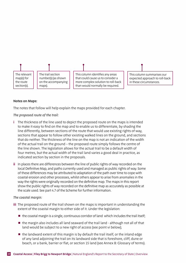
The relevant map(s) for the route section(s).
This column specifies the current access status of the proposed trail section.
This column specifies existing surface type of the proposed trail section.
This column indicates where the landward boundary of the coastal margin would be, adjacent to each route section. This might be by default, because it meets the description of ‘coastal land types’ in the Scheme, or because we propose to exercise our discretion to extend or reduce the margin.
The relevant map(s) for the route section(s).
The trail section number(s) (as shown on the accompanying maps).
This column describes other options we considered for the route or margin for the identified route section(s).
This column summarises the reason(s) that the other options we considered were not preferred.
Coastal Access | Filey Brigg to Newport Bridge | Natural England’s Report to the Secretary of State | Overview10
6.2.3 Roll-back implementation – more complex situations: Maps 6a to 6g Sandsend Bridge to Staithes Beck
Map(s) Section numbers(s) Feature or site potentially affected
How we will manage roll-back in relation to this feature or site
6a, 6d, 6f and 6g
FNG-6-S001 to FNG-6-S002,FNG-6-S006 to FNG-6-S007,FNG-6-S033, FNG-6-S039, and FNG-6-S041 to FNG-6-S045
Buildings and curtilage
If it is no longer possible to find a viable route seaward of the specified excepted land (e.g. buildings, curtilage, gardens etc.), we will choose a route landward of it, following discussions with owners and occupiers.
The relevant map(s) for the route section(s).
The trail section number(s) (as shown on the accompanying maps).
This column summarises our expected approach to roll-back in these circumstances.
This column identifies any areas that could cause us to consider a more complex solution to roll-back than would normally be required.
Notes on Maps:
The notes that follow will help explain the maps provided for each chapter.
The proposed route of the trail:
i The thickness of the line used to depict the proposed route on the maps is intended to make it easy to find on the map and to enable us to differentiate, by shading the line differently, between sections of the route that would use existing rights of way, sections that appear to follow other existing walked lines on the ground, and sections that do neither. The thickness of the line on the map is not an indication of the width of the actual trail on the ground – the proposed route simply follows the centre of the line shown. The legislation allows for the actual trail to be a default width of four metres, but the actual width of the trail land varies a good deal in practice, as indicated section by section in the proposals.
ii In places there are differences between the line of public rights of way recorded on the local Definitive Map, and paths currently used and managed as public rights of way. Some of these differences may be attributed to adaptation of the path over time to cope with coastal erosion and other processes, whilst others appear to arise from anomalies in the way the rights were originally recorded on the definitive map. The maps in this report show the public rights of way recorded on the definitive map as accurately as possible at the scale used. See part 4.7 of the Scheme for further information.
The coastal margin:
iii The proposed route of the trail shown on the maps is important in understanding the extent of the coastal margin to either side of it. Under the legislation:
the coastal margin is a single, continuous corridor of land which includes the trail itself;
the margin also includes all land seaward of the trail land - although not all of that land would be subject to a new right of access (see point vi below);
the landward extent of this margin is by default the trail itself, or the inland edge of any land adjoining the trail on its landward side that is foreshore, cliff, dune or beach, or a bank, barrier or flat, or section 15 land (see Annex B: Glossary of terms).
Coastal Access | Filey Brigg to Newport Bridge | Natural England’s Report to the Secretary of State | Overview 11
iv We have the discretion to propose that the landward boundary of the coastal margin should coincide with a recognisable physical feature on the ground – even if the effect of doing so is to add land into the margin, or to remove land from it. We may use this discretion:
to propose that instead of the default trail width of four metres set by the legislation, particular physical features such as walls, fences or pavement edges should be used where appropriate to define the landward extent of the trail land on that section of the route: such features cannot be depicted on the maps at the scale used, but they are described in the formal proposals which accompany each map;
to clarify or adjust the boundaries of an area of land included by default as margin, in order to create a better ‘fit’ with the circumstances on the ground; or
to propose in some places that additional areas of land should be added to the coastal margin landward of the trail: land which is affected by such proposals is indicated on the maps with a purple wash and described in the formal proposals which accompany each map.
Further explanation of these powers can be found at part 4.8 of the Coastal Access Scheme. Our proposals take full account of any views expressed by the owner or occupier of affected land about whether the powers should be used in any of these ways.
v Land which forms part of the coastal margin would be subject to access rights, other than:
any excepted land, such as land covered by buildings or their gardens or curtilage: Annex C summarises in full the categories of excepted land under the legislation; or
any land where coastal access rights would be excluded under our statutory powers: we indicate in the report where we already know of circumstances that make this necessary, and make any proposals accordingly.
vi Spreading room is the term used in the report to describe any land, other than trail land, which would form part of the coastal margin and would have public rights of access. It does not therefore include any excepted land within the margin, or any existing access land on the landward side of the trail that is omitted from the margin.
Annex B (Glossary of terms) includes a full definition of these terms which you may find helpful in understanding the report.
Voluntary access dedication
vii Land that was previously dedicated as access land under section 16 of the Countryside and Rights of Way Act 2000 (CROW) will become subject to the coastal access regime if it forms part of the coastal margin in any of the ways described above. There is also provision in the legislation for a land owner or long leaseholder to dedicate other land voluntarily as coastal margin if it lies adjacent to it or within it. Dedicating land as coastal margin disapplies the excepted land provisions within it, and may also make provision for the removal or relaxation of specific national restrictions that would otherwise apply. Section 4.8 of the Coastal Access Scheme explains these provisions in more detail.
Coastal Access | Filey Brigg to Newport Bridge | Natural England’s Report to the Secretary of State | Overview12
Preparation of the report
4. General approach
To secure the twin objectives under the legislation we have followed the approach set out in our Coastal Access Scheme, as approved by the Secretary of State on 9 July 2013. Chapter 3 of this detailed document sets out the stages of implementation we must follow.
In line with this, before making the proposals in this report, we conducted extensive preliminary work in two main stages:
Stage 1: Prepare – defining the extent of the coastal stretch with access authorities and identifying the key issues and opportunities, including sensitive features, in conjunction with key organisations; and
Stage 2: Develop – checking the alignment on the ground, sharing our initial thoughts with land owners and offering to ‘walk the course’ with them, planning for the protection of key features, talking further with key interests and reality checking our proposals.
Stage 1 - Prepare
This stage involved us working closely with access authorities to develop an understanding of the stretch, agree its exact extent and carry out initial familiarisation visits. We held discussions with representatives of national and local organisations with a strategic interest in this stretch of coast. This included discussions with those we are required by legislation to consult at this stage:
the local access forums;
County, District and Borough Council officers, including those responsible for ecology, geology, historic environment, planning, transport and countryside ranger staff;
officers of the relevant National Park Authority (North York Moors National Park Authority);
local officers from the Environment Agency, in relation to flood defence and coastal erosion management on this stretch of coast; and
local officers of English Heritage, in relation to historic features on this stretch of coast; and
We also held discussions with representatives of specific interest groups, including:
the Ramblers;
the Open Spaces Society;
the British Mountaineering Council;
the National Farmers Union;
the Royal Society for the Protection of Birds;
Industry Nature Conservation Association, Teesside;
Network Rail;
Coastal Access | Filey Brigg to Newport Bridge | Natural England’s Report to the Secretary of State | Overview 13
National Grid;
the British Association for Shooting and Conservation, and
the Country Land and Business Association.
We publicised on our website the start of work on the stretch and provided an opportunity for all other interested parties to submit to us their views on local issues and opportunities.
We also engaged with relevant specialists, both within Natural England and from other organisations, to consider any potential for impacts on key sensitive features. See part 5 below for more information.
In addition to these discussions we took into account a wide variety of information, plans and strategies that we considered relevant to the alignment process. Those that are published on the internet are listed in Annex A: Bibliography.
We then took all reasonable steps to identify owners, occupiers and those with a legal interest in the land which could be affected.
Stage 2 - Develop
This stage involved us contacting, and discussing our initial thoughts with, owners, occupiers and other legal interests.
We asked for their views and invited them to join us when we visited the land to ‘walk the course’ so that we could discuss options for alignment based on mapped summaries of our emerging proposals.
In many cases this was done either through separate site meetings with the individuals and businesses concerned or by the presentation of a “bespoke map” to relevant interests, showing our initial conclusions regarding the trail and margin. On the coastal section of the Cleveland Way National Trail, in those majority of places where we were minded to propose that the existing route be adopted as the route of the England Coast Path we generally issued maps to relevant interests asking for their views on this alignment of the trail and margin, offering to discuss any issues or opportunities, either by telephone, or on site.
We also took reasonable steps to identify and contact any owners, occupiers or other legal interests who could foreseeably be affected in the future as a result of any roll-back that may prove necessary. See part 8 – Future Change – below.
We then held further detailed discussions with internal and external specialists to refine our thinking on protecting key sensitive features, carrying out any necessary appraisals.
After further discussions with key local and national organisations we refined our proposals and checked them on the ground before moving onto Stage 3 – Propose, which is the substance of this report.
Coastal Access | Filey Brigg to Newport Bridge | Natural England’s Report to the Secretary of State | Overview14
5. Key issues along this stretch
a) Recreational Issues
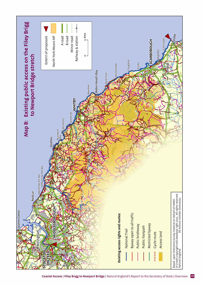
Map B gives an overview of existing public access to the coast between Filey Brigg and Newport Bridge, showing public rights of way, access land and the Cleveland Way National Trail.
The Cleveland Way already affords good linear coastal access from Filey Brigg north to Saltburn-by-the-Sea. The proposed route of the trail would follow the route currently managed as the Cleveland Way National Trail but near Staithes it would differ from that route, as shown on map 6g. If the Secretary of State approves our proposed route for the England Coast Path along this length of coast, we propose to modify the approved route of the existing national trail to coincide with the proposed route for the England Coast Path in places where the two diverge. We would do this by submitting a separate variation report to the Secretary of State, relating to the Cleveland Way National Trail.
This stretch is also home to the end of the highly popular Wainwright Coast to Coast walk, at Robin Hood’s Bay. The route reaches the village via the coastline north of the village for a short distance. The proposed route for the England Coast Path will therefore provide an improved and secure final stage for Wainwrights’ classic route.
The open coast north of Saltburn-by-the-Sea as far as Coatham Marsh, Redcar, is served by public rights of way, roads and promenades. In general we have proposed that the route coincides with these.
From Coatham Marsh to Newport Bridge, Middlesbrough, it is proposed that the route follow the Teesdale Way, a locally promoted long distance walking route, with minor variations in Middlesbrough town centre.
In addition there are extensive areas of land with wider rights of access (Registered Common Land) to the south of the stretch, at Beast Cliff, Ravenscar, at Hayburn Wyke and at Cayton Bay, Scarborough. The coastal margin described in the later chapters of the report would include these areas and if the report is approved, coastal access rights would replace the access rights currently provided under CROW. There would also be spreading room over suitable additional land where there are currently no secure public rights of access - for example on the Stray at Redcar (see chapter 8 of the proposals). The majority of this coastal margin is owned by local authorities or the National Trust. It includes land on the seaward side of the trail, which would become accessible by default under the legislation, and extensive areas on the landward side, where we are using our discretion to propose additional coastal margin, with the support of the affected land owners.
Local user groups asked us to consider whether the route should be aligned along the spit at South Gare, north of Redcar, in order to incorporate a viewpoint. This issue is addressed in chapter 8 of the proposals.
Coastal Access | Filey Brigg to Newport Bridge | Natural England’s Report to the Secretary of State | Overview 15
b) Natural environment
Data relating to the natural environment was collated for us by North Yorkshire County Council, North York Moors National Park Authority, Redcar & Cleveland Borough Council and Middlesbrough Borough Council and then assessed by officers from Natural England and the highway authorities listed above, with knowledge of the conservation objectives of the sites and features under consideration. We looked for evidence of any potential for our proposals to have a detrimental effect on protected sites and species. This included potential effects arising from the works that would be necessary to establish and/or maintain the proposed route and from people’s use of the new access rights.
We paid particular regard to sites with certain key designations for their wildlife and/or geological interest (See Map C: Key statutory environmental designations on Filey Brigg to Newport Bridge stretch):
European sites, including: Special Areas of Conservation (SAC), Special Protection Areas (SPA) , potential SPAs and Ramsar sites (see glossary for a fuller explanation of ‘European sites’); and
Sites of Special Scientific Interest (SSSI) and proposed SSSIs.
In order to comply with the letter and spirit of the law, throughout the Habitats Regulations Assessment process relating to European sites described below, the Natural England staff scrutinising the proposals and providing specialist environmental advice have maintained clearly distinct and separate roles from those preparing them. As a matter of good practice, staff also adopted this separation of roles in assessing the potential for our proposals to affect other protected sites and species, including SSSIs, National Nature Reserves (NNRs) and Local Nature Reserves (LNRs).
With regard to European sites, a Habitats Regulations Assessment was carried out on the proposals in this report, using procedures compliant with the associated legislation. We concluded there will be no likely significant effect on any of the qualifying features of the European site, either alone or in combination with other plans or projects. We therefore advise the Secretary of State that further assessment in this respect is not required. In reaching this conclusion we have taken account of discussions with local user groups operating voluntary codes in the area, to avoid disturbance to cliff nesting birds during the breeding season. Our proposals incorporating these measures are described in Chapter 1 of the proposals.
Once a route for the trail has been confirmed by the Secretary of State, we will hold further discussions with relevant environmental specialists from Natural England and the access authorities (North Yorkshire County Council, North York Moors National Park Authority, Redcar & Cleveland Borough Council and Middlesbrough Borough Council) about any works on the ground that are necessary to prepare for commencement of the access rights.
Refer to our published Access and Sensitive Features Appraisal for more information.

Coastal Access | Filey Brigg to Newport Bridge | Natural England’s Report to the Secretary of State | Overview16
c) Historic Environment
Data relating to historic sites and features was collated for us by North Yorkshire County Council, North York Moors National Park Authority, Redcar & Cleveland Borough Council and Middlesbrough Borough Council. This included data about the presence of historic sites and features on this stretch of coast and specialist advice as to any potential vulnerability of the sites and features to access. The data was then assessed by Natural England in consultation with officers from English Heritage and officers from North Yorkshire County Council, North York Moors National Park Authority, Redcar & Cleveland Borough Council and Middlesbrough Borough Council. We looked for evidence of any potential for our proposals to have a detrimental effect on protected sites or features. This included potential effects arising from the works that would be necessary to establish and/or maintain the proposed route and from people’s use of the new access rights.
We paid particular regard to Scheduled Monuments (See Map C: Key statutory environmental designations on the Filey Brigg to Newport Bridge stretch).
Our conclusion from this assessment is that our proposals would not undermine the conservation objectives for the historic environment within the Filey Brigg to Newport Bridge stretch.
No specific measures have been identified as necessary to support this conclusion. However, once a route for the trail has been confirmed by the Secretary of State, we will hold further discussions with English Heritage and relevant officers from North Yorkshire County Council, North York Moors National Park Authority, Redcar & Cleveland Borough Council and Middlesbrough Borough Council as part of finalising the design and location of any works that are necessary to establish the route.
d) Interests of owners and occupiers
In discharging our coastal access duty we must aim to strike a fair balance between the interests of the public in having rights of access over coastal land, and the interests of owners and occupiers of land over which any coastal access rights would apply. This was a key driver in the design of our proposals, which were discussed in detail with the owners and occupiers of the affected land during ‘walking the course’ and other processes, and are reflected in the chapters of the report insofar as they were relevant to the individual lengths of coast described.
‘Rural coast’
Between the towns of Filey, Scarborough, Whitby and Saltburn-by-the-Sea the coast is mainly rural in nature and consists of mixed farmland, often on the cliff tops. Tourism is a major contributor to the economy of the area, with the Cleveland Way being a well-established and attractive walk.
In general, landowners are accepting of the existing National Trail and understand the benefits that it brings to the area. The comments we have received from landowners and occupiers have overwhelmingly expressed a desire for the England Coast Path to adopt the route of the existing Cleveland Way.
Coastal Access | Filey Brigg to Newport Bridge | Natural England’s Report to the Secretary of State | Overview 17
‘Urban Coast’
There are several towns and villages on the open coast of the stretch, from Scarborough in the south, to Redcar in the north. All of these urban areas are dependant to some extent on tourism, including walkers, although they also function as ports, residential centres and have some light industry.
The Cleveland Way currently passes through all of these communities with the exception of Marske-by-the-Sea and Redcar, generally taking a route close to the sea, along promenades and highways. In Marske-by-the-Sea and Redcar we have chosen to take the trail as close to the sea as possible, similarly making use of promenades and other existing areas with public access such as Redcar Stray.
No major issues were raised by owners and occupiers in urban areas during the early stages of the planning for this stretch. Any possible issues based on the extent of the coastal margin are to a large extent addressed by the provisions in the legislation for particular categories of land to be automatically excepted from the coastal access rights – such as land covered by gardens, buildings and their curtilage.
In Marske-by-the-Sea local residents suggested that the route of the England Coast Path should cross the very top of the beach, rather than pass in front of their properties, thereby avoiding a road crossing and a short inland diversion. Having visited the site and consulted the Coastguard, this choice appeared to be both safe and convenient (see chapter 8 of the proposals) as it crosses part of the beach which is firm and very rarely inundated by the tide.
Land which becomes subject to development in the future will usually also become excepted from the coastal access rights, where it falls within the coastal margin. Annex C of the Overview sets out these provisions in more detail.
Generally, our proposals would make little practical difference to activity in the urban areas on this stretch; most such areas in the coastal margin are already well-used by the public and the trail tends to follow existing public routes.
‘Industrial Coast’
The northern part of the stretch, from Coatham Marsh to Newport Bridge (see chapter 9 of the proposals) is largely industrial, or post-industrial, in nature. This includes some attractive reclaimed industrial sites, for example at Coatham Marsh and along the River Tees west of Middlesbrough.
The proposed route through this area is generally that followed by the Teesdale Way (see Map B: Existing public access on the Filey Brigg to Newport Bridge stretch). No significant issues were raised by landowners or occupiers regarding this route, which is mainly aligned along public footpaths, or footways by public highways, however despite the extensive pattern of physical enclosure that characterises the developed areas, some serious concerns were raised regarding the potential public perception that access would become available within them as default coastal margin. Following discussions and site visits to the area, we have proposed that the coastal access rights should be excluded from the majority of the land between the proposed route and the River Tees, on the grounds of public safety and land management requirements (see Part 9 of the Overview - Restrictions and Exclusions).
Coastal Access | Filey Brigg to Newport Bridge | Natural England’s Report to the Secretary of State | Overview18
e) Coastal processes
The principal source of information regarding coastal processes on this stretch of coast is the River Tyne to Flamborough Head Shoreline Management Plan (see Annex A: Bibliography), a non-statutory policy document for the management of flood risk and coastal erosion. With reference to this document, and with advice from the Environment Agency and officers from relevant local authorities, we have identified the lengths of coast within this stretch which are particularly susceptible to coastal erosion or other geomorphological processes, such as landslips.
In general where the coast is defended with some certainty, we have not made any specific proposals to enable the trail to adapt to coastal change - for example, where the trail would be:
on, or on the landward side of sea defences which would protect it; or
landward of the roads and railway which would be protected under the policies set out in the Shoreline Management Plan 2.
However, in some cases we have identified a possible requirement for roll-back even in scenarios like this; to ensure that we can maintain continuity of the trail should a nearby section of the trail be affected by coastal change (see Part 4.10 of the approved Scheme).
The developed areas of Scarborough, Robin Hood’s Bay, Whitby, Saltburn-by-the-Sea and Redcar, described in chapters 1 to 8 of the proposals, are defended by sea defence structures and are unlikely to be affected significantly by coastal processes in the foreseeable future. We have not made any specific proposals to enable the trail to adapt to control coastal change on these lengths of coast.
The eroding cliffs along the open, rural coast described in chapters 1 to 8 of the proposals are largely undefended and subject to varying rates of change. On these lengths of coast we propose to recommend that the trail is able to roll back so that it can be repositioned without further reference to the Secretary of State, once she has approved the initial route. There is more detail about these roll-back arrangements in part 7 of the Overview and in the relevant chapters of the proposals.
The estuary of the River Tees is not subject to the same coastal processes as the open coast (see chapter 9 of the proposals). We have not made any specific proposals to enable the trail to adapt to coastal change on these lengths of coast.
Coastal Access | Filey Brigg to Newport Bridge | Natural England’s Report to the Secretary of State | Overview 19
SCA
RBO
ROU
GH
WH
ITBY
STO
CK
TON
-O
N-T
EES
MID
DLE
SBO
ROU
GH
Map
B:
Exi
stin
g p
ublic
acc
ess
on th
e Fi
ley
Brig
g
to
New
por
t Bri
dge
stre
tch
Exis
tin
g ac
cess
rig
hts
and
rou
tes:
!!
!!
!!

Coastal Access | Filey Brigg to Newport Bridge | Natural England’s Report to the Secretary of State | Overview20
SCA
RBO
ROU
GH
WH
ITBY
STO
CK
TON
-O
N-T
EES
MID
DLE
SBO
ROU
GH
Map
C:
Key
sta
tuto
ry e
nvir
onm
enta
l des
igna
tion
s
on
the
File
y Br
igg
to N
ewp
ort B
rid
ge s
tret
ch
His
tori
c en
viro
nmen
t des
ign
atio
ns:
Nat
ural
en
viro
nm
ent
desi
gnat
ion
s:

Coastal Access | Filey Brigg to Newport Bridge | Natural England’s Report to the Secretary of State | Overview 21
Implementation of the proposals
6. Physical establishment of the trail
Below we summarise how our proposed route for the trail would be physically established to make it ready for public use before any new rights come into force. There is further detail in the proposals about some of the provisions mentioned here.
The trail would make extensive use of existing coastal paths on the ground, including the existing route of the coastal part of the Cleveland Way National Trail. In other places, new paths would need to be created or existing walked routes significantly improved, in order to bring them up to National Trail standards. Our estimate of the capital costs for physical establishment of the trail on the proposed route is £79,850 (exclusive of any VAT payable) and is informed by:
information already held by the access authorities, North Yorkshire County Council, North York Moors National Park Authority, Redcar & Cleveland Borough Council and Middlesbrough Borough Council, in relation to the management of the existing public rights of way, including the Cleveland Way National Trail; and
information gathered while visiting affected land and talking to the people who own and manage it about the options for the route.
The main elements to the overall cost are as follows:
A significant number of new signs would be needed on the trail, in particular on sections where the proposed route differs from that of the existing Cleveland Way and on those sections north of Saltburn-by-the-Sea where there is no existing National Trail.
Any signs and information boards with outdated information about the existing route of Cleveland Way would require replacement.
The surfaces and access furniture of the existing paths and footways on the proposed route are generally of a suitable standard for the trail, but there are some places where new steps, footbridges and gates would enhance the convenience of the trail. These are mentioned in the detailed descriptions for the relevant route sections in the proposals.
Table 1 explains our estimate of the capital cost for each of the main elements of physical establishment described above.
Table 1: Estimate of capital costs
Item Cost Signs & interpretation £38,850 Steps £1700 Bridges £26,500 Dropped kerbs £4,000 Boundary crossing £800Path Works £15,000Project management £3,000Total £89,850 (Exclusive of any VAT payable)
Once the Secretary of State’s decision on our report has been notified, we, or the appropriate access authorities on our behalf, will consult further with affected land owners and occupiers about relevant aspects of the design, installation and maintenance of the new signs and infrastructure that are needed. All such works would conform to the published standards for National Trails and the other criteria described in our Coastal Access Scheme.
Coastal Access | Filey Brigg to Newport Bridge | Natural England’s Report to the Secretary of State | Overview22
7. Maintenance of the trail
Because the trail between Filey Brigg and Newport Bridge will form part of the National Trail being created around the whole coast of England called the England Coast Path, we envisage that it will be maintained to the same high quality standards as other National Trails in England (see The New Deal; Management of National Trails in England from April 2013 at Annex A).
Our estimate of the annual cost to maintain the trail is £83,053 (exclusive of any VAT payable).
In developing this estimate we have taken account of the formula used to calculate Natural England’s contribution to the maintenance of other National Trails.
8. Future changes
Below we explain the procedures for future changes to the coastal access provisions, once proposals have been approved by the Secretary of State. Where the need for future changes was foreseeable at the time of preparing the proposals we have indicated this in the relevant chapters.
Roll-back
Chapters 1 to 8 of the proposals include proposals for the route to ‘roll back’ either:
in direct response to coastal erosion or other geomorphological processes, or significant encroachment by the sea; or
in order to link with other parts of the route that need to roll back as a direct result of coastal erosion or other geomorphological processes, or significant encroachment by the sea.
Where sections of the approved route need to change for these reasons in order to remain viable, the new route will be determined by Natural England without any requirement for further reference to the Secretary of State. Coastal erosion can happen at any time and so, in some cases, this provision may need to be invoked between approval of the report and commencement of new access rights.
In particular, so far as we consider it necessary in order to maintain the viability of the route as a whole, we may determine that any part of the route is to be repositioned landward of any physical boundary feature, area of excepted land or area from which we consider it necessary to exclude access e.g. a protected site designated for its conservation value.
In determining the new route, we will take into account:
the local factors present at that time, including any views expressed by people with a relevant interest in affected land;
the terms of the Coastal Access duty (see Annex B: Glossary of terms), including the requirement to aim to strike a fair balance between the interests of the public and the interests of any person with a relevant interest in the land; and
the criteria set out in part B of the Coastal Access Scheme.

Coastal Access | Filey Brigg to Newport Bridge | Natural England’s Report to the Secretary of State | Overview 23
Any changes to the route in accordance with these proposals will come into force on a date decided by us. On this date, coastal access rights will come into force as necessary along any new alignment. The date of change will follow any necessary physical establishment work, including any installation of signs to enable the public to identify the modified route on the ground. We will take reasonable steps to ensure that anyone with a relevant interest in land directly affected by the change is made aware this date.
In places where the trail rolls back in this way in response to coastal change, the landward extent of the coastal margin may also move inland:
with the trail itself, or
because an area of Section 15 land (see Annex B: Glossary of terms) or foreshore, cliff, dune, or beach, or a bank, barrier or flat, newly touches the trail when it rolls back, with the result that it automatically becomes part of the coastal margin under the terms of the legislation.
Whilst coastal change is inherently difficult to predict with any accuracy, this report identifies those parts of the stretch where we consider such powers are likely to be needed over time in order to ensure continuity of the trail. These are as follows:
Chapter 1 – much of the length covered by this chapter (maps 1a to 1h)
Chapter 2 – from Scarborough Sealife Centre to Ravenscar (maps 2b to 2j)
Chapter 3 – all of the coast covered by this chapter (maps 3a to 3c)
Chapter 4 – from Robin Hood’s Bay to Whitby Abbey (maps 4a to 4f)
Chapter 5 – from Whitby Abbey to Whitby and near Whitby Golf Club (maps 5a to 5b)
Chapter 6 – all of the coast covered by this chapter (maps 6a to 6g)
Chapter 7 – all of the coast covered by this chapter (maps 7a to 7h)
Chapter 8 – between Saltburn-by-the-Sea and Marske-by-the-Sea and between Marske-by-the-Sea and Redcar (maps 8a to 8g)
Ordinarily, where roll-back has been proposed and becomes necessary, we would expect the trail to be adjusted to follow the current feature (for example, the cliff edge or top of foreshore). Where we foresee that local circumstances will require more detailed consideration, we have provided further information within the tables in Part 2 of the relevant report chapters. This and the above information is intended as a guide only, based on information available to us at the time of writing this report, and on expert advice provided by the access authority, Environment Agency and others. We have taken and will continue to take all reasonable steps to discuss implications and options with all parties likely to affected by such changes, both during the initial planning work that preceded the writing of this report and during any subsequent work to plan and implement a ‘rolled back’ route.
Other changes
We will normally be required to submit a variation report seeking approval from the Secretary of State in order to make other changes to the route of the trail or the landward boundary of the coastal margin - for example if the land was subject to
Coastal Access | Filey Brigg to Newport Bridge | Natural England’s Report to the Secretary of State | Overview24
new build development. Such changes would be subject to the same procedures for consultation, representations and objections as our initial reports. There are no potential developments of which we are already aware that could potentially affect the route on the Filey Brigg to Newport Bridge stretch.
However, even without a variation report:
i We would be able to impose new or modify existing local restrictions or exclusions on coastal access rights as necessary, and people with a legal interest in the land would be able to apply to us for such directions under certain circumstances – see chapter 6 of the Coastal Access Scheme.
ii Further work could be carried out where necessary either to establish or maintain the route, or to provide any means of access to the coastal margin, using powers and procedures set out in Schedule 20 of the Marine and Coastal Access Act 2009 and chapter 3 of the Countryside and Rights of Way Act.
iii If at any time the use of affected land should change, the normal rules in relation to excepted land would apply, so for example land covered by buildings and their curtilage, and land in the course of development, would automatically become excepted from the coastal access rights – see Annex C: Excepted Land Categories.
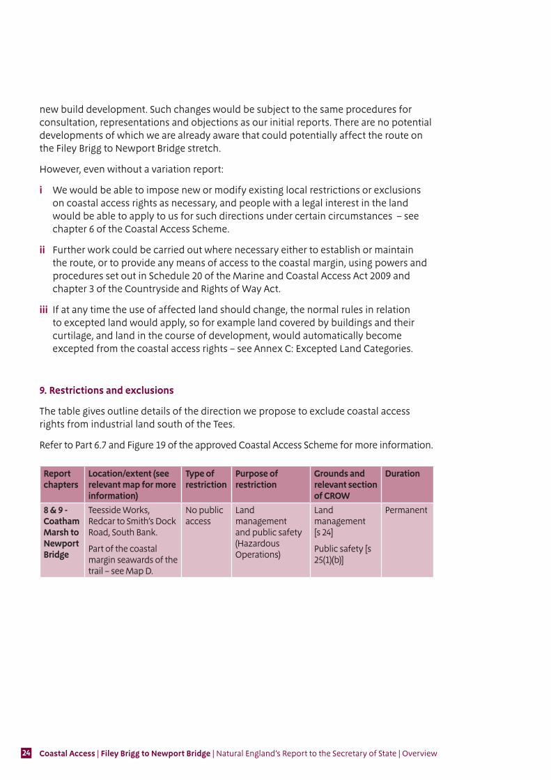
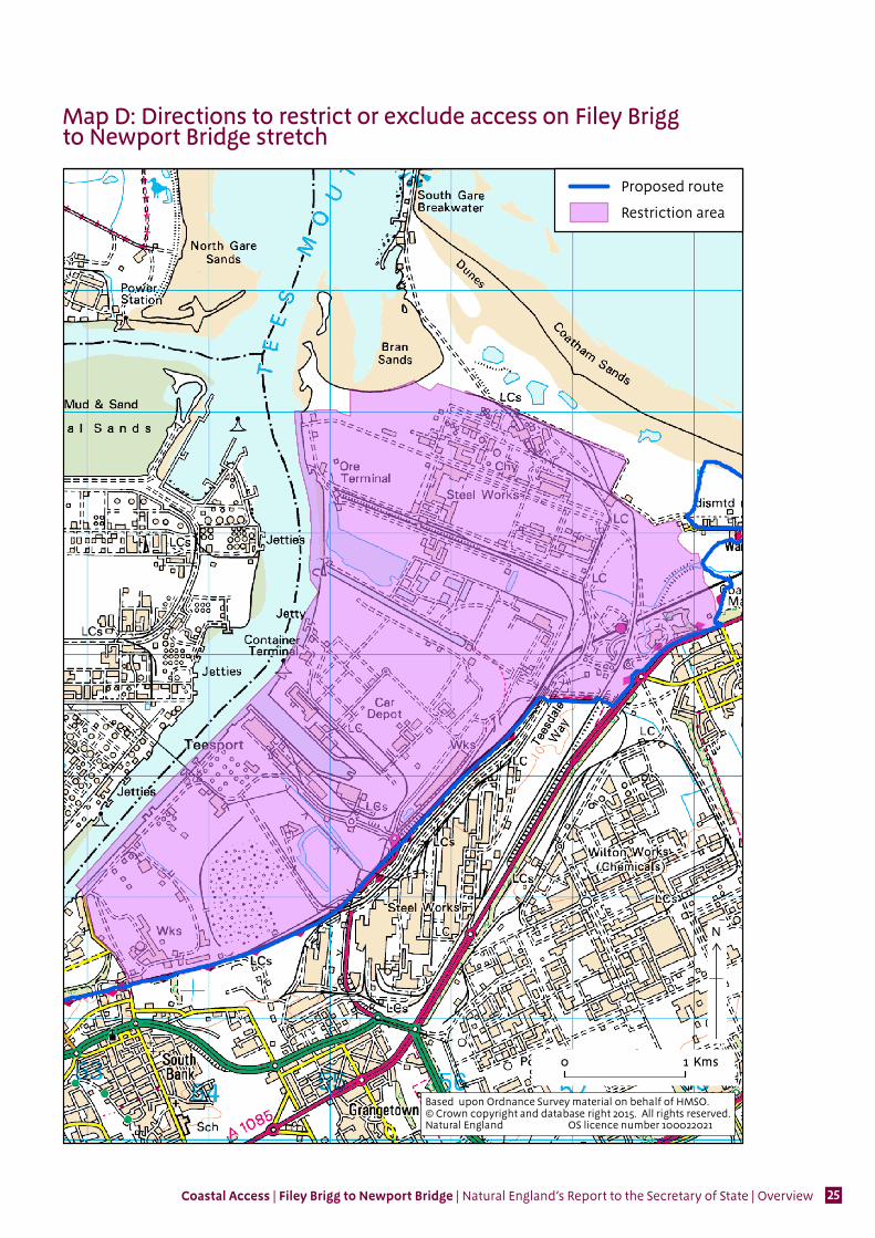
9. Restrictions and exclusions
The table gives outline details of the direction we propose to exclude coastal access rights from industrial land south of the Tees.
Refer to Part 6.7 and Figure 19 of the approved Coastal Access Scheme for more information.
Report chapters
Location/extent (see relevant map for more information)
Type of restriction
Purpose of restriction
Grounds and relevant section of CROW
Duration
8 & 9 - Coatham Marsh to Newport Bridge
Teesside Works, Redcar to Smith’s Dock Road, South Bank.
Part of the coastal margin seawards of the trail – see Map D.
No public access
Land management and public safety (Hazardous Operations)
Land management [s 24]
Public safety [s 25(1)(b)]
Permanent
Coastal Access | Filey Brigg to Newport Bridge | Natural England’s Report to the Secretary of State | Overview 25
Map D: Restriction Boundary
0 1 Kms
N
×
Restriction area
Proposed route
Based upon Ordnance Survey material on behalf of HMSO.© Crown copyright and database right 2015. All rights reserved.Natural England OS licence number 100022021
Map D: Directions to restrict or exclude access on Filey Brigg to Newport Bridge stretch
Coastal Access | Filey Brigg to Newport Bridge | Natural England’s Report to the Secretary of State | Overview26
Annexes
Annex A: Bibliography
Information about Natural England’s coastal access programme
Natural Englandwww.gov.uk/government/collections/england-coast-path-improving-public-access-to-the-coast
Information about the statutory framework for coastal access
Department for Environment, Food and Rural Affairswww.gov.uk/government/publications/marine-and-coastal-access-act-2009
Coastal Access SchemeNE446 - Coastal Access: Natural England’s Approved SchemeNatural England http://publications.naturalengland.org.uk/publication/5327964912746496
Marine and Coastal Access Act 2009Department for Environment, Food and rural Affairs www.legislation.gov.uk/ukpga/2009/23/part/9/crossheading/the-coastal-access-duty
Countryside & Rights of Way Act 2000 [CROW] www.legislation.gov.uk/ukpga/2000/37/contents
The Access to the Countryside (Coastal Margin) (England) Order 2010www.legislation.gov.uk/uksi/2010/558/contents/made
National Parks and Access to the Countryside Act 1949www.legislation.gov.uk/ukpga/Geo6/12-13-14/97
The Coastal Access Reports (Consideration and Modification Procedure) (England) Regulations 2010www.legislation.gov.uk/uksi/2010/1976/contents/made
Environmental legislation referred to in the report
Strategic Environmental Assessment Directive (Directive 2001/42/EC of the European Parliament and of the Council of 27 June 2001 on the assessment of the effects of certain plans and programmes on the environment) European Commission http://ec.europa.eu/environment/eia/sea-legalcontext.htm
Habitats Directive (Council Directive 92/43/EEC of 21 May 1992 on the conservation of natural habitats and of wild fauna and flora) European Commission http://ec.europa.eu/environment/nature/legislation/habitatsdirective/index_en.htm

Coastal Access | Filey Brigg to Newport Bridge | Natural England’s Report to the Secretary of State | Overview 27
Other published information used in the preparation of the report
A register of coastal climbing sites in England British Mountaineering Council www.thebmc.co.uk/Download.aspx?id=692
Redcar and Cleveland Rights of Way Improvement Plan Stockton-on-Tees Borough Councilwww.redcar-cleveland.gov.uk/rcbcweb.nsf/D73305F95D1EACAB802572E4004B2BF9/$File/final%20rowip.pdf
Scarborough Borough Local Plan (draft)Scarborough Borough Councilwww.scarborough.gov.uk/pdf/DRAFT%20SBLP_May%202014_FINALfor%20web.pdf
North York Moors National Park Local Development FrameworkNorth York Moors National Park Authoritywww.northyorkmoors.org.uk/planning/framework
Redcar and Cleveland Local Plan (draft)Redcar and Cleveland Borough Councilhttp://redcarcleveland-consult.limehouse.co.uk/portal/local_plan/dlp?pointId=2545685#document-2545685
Middlesbrough Local Development FrameworkMiddlesbrough Borough Councilwww.middlesbrough.gov.uk/CHttpHandler.ashx?id=6464&p=0
The New deal; Management of National Trails in England from April 2013 (NE426)Publications.naturalengland.org.uk/publication/6238141
Shoreline Management Plan- River Tyne to Flamborough HeadNorth East Coastal Authorities Group Lead- Scarborough Borough Councilwww.northeastsmp2.org.uk/finalSMP2.htm
Coastal Access | Filey Brigg to Newport Bridge | Natural England’s Report to the Secretary of State | Overview28
Annex B: Glossary of termsThe terms and their explanations below are simply for guidance and are not intended to have any legal effect.
Any terms shown in bold type within each explanation are included as a separate entry elsewhere in the glossary.
1949 Act means the National Parks and Access to the Countryside Act 1949. The 1949 Act includes provisions and procedures for the creation of long-distance routes (now more commonly known as National Trails). These provisions were amended and added to by the 2009 Act for the purpose of identifying the coastal trail. See bibliography for publication details.
2009 Act means the Marine and Coastal Access Act 2009. Part 9 of the 2009 Act includes provisions to improve public access to the coast. There are supplementary provisions relating to:
■ consideration of coastal access reports, objections and representations by the Secretary of State – in Schedule 1A of the 1949 Act (inserted by Schedule 19 of the 2009 Act);
■ the establishment and maintenance of the English coastal route – in Schedule 20 of the 2009 Act.
Section 1.2 of the Coastal Access Scheme includes a brief overview of the main provisions, which are explained in more detail in subsequent chapters. See bibliography for publication details.
alignment is the term the report uses to describe the choices we make about the proposed route of the trail and the landward boundary of the coastal margin.
alternative route means a route proposed to the Secretary of State as part of our report for a stretch of coast, for use by the public at times when access along part of the normal route is excluded under a direction. The associated term optional alternative route denotes an alternative route which the public has the option to use at times when the normal route (even though not formally closed) is unsuitable for use because of flooding, tidal action, coastal erosion or other geomorphological processes. Figure 17 in chapter 6 of the Scheme explains alternative routes in more detail. Paragraphs 4.10.16 to 4.10.18 of the Scheme explain more about the potential use of optional alternative routes.
appropriate assessment means, for the purposes of the Scheme, an assessment of the implications of a plan or project for a European site in view of the site’s conservation objectives, made in accordance with Article 6.3 of the Habitats Directive. Natural England is required to conduct an appropriate assessment where it concludes that the introduction of coastal access rights in the form proposed is likely to have a significant effect on the conservation objectives for a European site. Our proposals to the Secretary of State include as necessary any local measures designed to prevent such a likely significant effect arising from improved access. Section 4.9 of the Scheme explains in more detail how we fulfil this requirement where it is relevant.
Coastal Access | Filey Brigg to Newport Bridge | Natural England’s Report to the Secretary of State | Overview 29
Birds Directive means the European Community Council Directive 2009/147/EEC on the conservation of wild birds. See bibliography for publication details.
building has the same meaning given in Schedule 1 of CROW, as amended for the coast by the Order. The term includes any structure or erection and any part of a building. For this purpose “structure” includes any tent, caravan or other temporary or moveable structure. It does not include any fence or wall, anything which is a means of access (as defined by CROW section 34 – for example steps or bridges), or any slipway, hard or quay.
coastal access duty means Natural England’s duty under section 296 of the 2009 Act to secure improvements to public access to the English coast. It is explained in more detail in 1.2 of the Coastal Access Scheme.
coastal access rights is the term the report uses to describe the rights of public access to the coast provided under section 2(1) of CROW as a result of the provisions of the 2009 Act and the Order. Coastal access rights are normally rights of access on foot for open-air recreation. These rights are by default subject to national restrictions and may additionally be subject to directions which restrict or exclude them locally. Section 2.4 of the Coastal Access Scheme explains more about the nature and management of coastal access rights.
coastal margin or margin means a margin of land at the coast falling within one or more of the descriptions given at article 3 of the Order. It is explained at section 1.3. Its main component is land subject to the coastal access rights, but it also contains other land, including some land that is not accessible to the public. A land owner may also voluntarily include land in the coastal access margin by making a dedication. Section 2.3 of the Scheme explains these other categories of land and how they fit in.
coastal processes is a term used in the report to mean coastal erosion, encroachment by the sea or other physical change due to geomorphological processes such as landslip. Where any part of the trail could be significantly affected by coastal processes, either directly or because of the need to maintain continuity with a part that is directly affected, we have included recommendations for it to roll back in accordance with a description in the report.
CROW means the Countryside and Rights of Way Act 2000. Coastal access rights take effect by virtue of CROW section 2(1). Certain provisions in CROW are amended or added to by the 2009 Act and the Order for the purposes of the coast. Chapter 2 of the Coastal Access Scheme provides an overview of how the amended CROW provisions apply to the coast. See bibliography for publication details.
dedicate/dedication means any voluntary dedication of land by the owner or long leaseholder under section 16 of CROW so that it will be subject to access rights under that Act. A dedication may also make provision for specific national restrictions that would otherwise apply over the affected land to be removed or relaxed.
Land within the coastal margin that was previously dedicated as access land under CROW becomes subject to the coastal access regime, including the national restrictions and the reduced level of liability operating on other parts of the margin with coastal access rights. On certain land, a dedication may be used to ‘opt in’ to the coastal access regime land where it would not otherwise apply. Chapter 2 of the Coastal Access Scheme explains these scenarios in more detail.
Coastal Access | Filey Brigg to Newport Bridge | Natural England’s Report to the Secretary of State | Overview30
definitive map means the legal record of public rights of way. It shows public footpaths, bridleways, restricted byways, and byways open to all traffic.
direction means a direction under chapter II of CROW Part 1 to impose local restrictions or exclusions on the use of the coastal access rights.
European site means a site:
■ classified as a Special Protection Area (SPA) for birds under the Birds Directive; or
■ designated as a Special Area of Conservation (SAC) under the Habitats Directive; or
■ proposed to the European Commission as a site eligible for designation as a SAC for the purposes of Article 4.4 of the Habitats Directive (a candidate SAC).
Natural England is required in the circumstances described under appropriate assessment above to conduct such an assessment of the implications of the introduction of coastal access rights for European sites. It is Government policy, stated in the National Planning Policy Framework that, whilst not European sites as a matter of law, the following sites should be subject to the same procedures and protection as European sites:
■ Any potential SPA or possible SAC;
■ Any site listed or proposed as a Wetland of International Importance especially as Waterfowl Habitat under the Ramsar Convention on Wetlands of International Importance 1971 (a Ramsar site); and
■ Sites identified, or required, as compensatory measures for adverse effects on European sites, potential Special Protection Areas, possible Special Areas of Conservation, and listed or proposed Ramsar sites.
For this purpose, any reference in the report to a European site or sites should be taken to include all the categories of site above.
excepted land – see Annex C of the Overview.
exclude/exclusion are terms the report uses to refer to local exclusion of the coastal access rights by direction (as opposed to the national restrictions that apply on all coastal access land by default). In this way the use of the rights may where necessary either be excluded completely, or restricted in specified ways by means of a local restriction. Section 6.6 of the Coastal Access Scheme explains the provisions in detail and our approach to their use.
foreshore is not defined in the 2009 Act or the Order. In the report it is taken to mean the land between mean low water and mean high water.
gate is used in several ways in the report:
■ ‘Field gate’ means a wide farm gate, for vehicle access.
■ ‘Kissing gate’ means a pedestrian access gate, sometimes suitable for wheelchairs.
■ ‘Wicket gate’ means a narrow field gate, sometimes suitable for wheelchairs, but unsuitable for larger vehicles.

Coastal Access | Filey Brigg to Newport Bridge | Natural England’s Report to the Secretary of State | Overview 31
guide fencing is a term the report uses to describe simple temporary fencing which can be put up and taken down with minimal cost or effort – see figure 18 in chapter 6 of the Coastal Access Scheme.
Habitats Directive means the European Community Council Directive 92/43/EEC on the conservation of natural habitats and of wild fauna and flora. See bibliography for publication details.
the legislation is the term the report uses to describe four pieces of legislation which include provisions relevant to the implementation of our proposals: the 2009 Act, the 1949 Act, CROW and the Order. There are separate entries in the glossary which describe each of these in more detail.
local access forum means a local access forum established under section 94 of CROW. Natural England is required to consult the relevant Local Access Forum in the preparation of the report, and to invite representations from it on its report – see chapter 3 of the Coastal Access Scheme for details.
national restrictions – see Annex D of the Overview.
National Trail means a long-distance route approved by the Secretary of State under section 52 of the 1949 Act.
objection means an objection by a person with a relevant interest in affected land to Natural England about a proposal in the report. An objection must be made on certain specified grounds, in accordance with the provisions in Schedule 1A of the 1949 Act (as inserted by Schedule 19 of the 2009 Act). Stage 3 of the implementation process described in chapter 3 of the Coastal Access Scheme provides an overview of the procedures for considering objections.
Order means the Access to the Countryside (Coastal Margin) (England) Order 2010 (S.I. 2010/558), made under section 3A of CROW. It sets out descriptions of land which are coastal margin and amends Part I of CROW in certain key respects for the purposes of coastal access. See bibliography for publication details.
public right of way (PRoW) means a public footpath, bridleway, restricted byway or byway open to all traffic. These public rights of way are recorded on the definitive map.
relevant interest means a relevant interest in land, as defined by section 297(4) of the 2009 Act. This is a person who:
■ holds an estate in fee simple absolute in possession in the land;
■ holds a term of years absolute in the land, or
■ is in lawful occupation of the land.
A relevant interest must therefore own or occupy the land in question, rather than simply having some kind of legal interest over it.

Coastal Access | Filey Brigg to Newport Bridge | Natural England’s Report to the Secretary of State | Overview32
representation means a representation made by any person to Natural England regarding a proposal in its final report. A representation may be made on any grounds, in accordance with the provisions in Schedule 1A of the 1949 Act (as inserted by Schedule 19 of the 2009 Act). Stage 3 of the implementation process described in chapter 3 of the Coastal Access Scheme provides an overview of the procedures for considering representations.
restrict/restriction – see “exclude/exclusion”.
Roll-back is the term the Scheme uses to describe arrangements made under the provisions of section 55B of the 1949 Act, whereby we may propose to the Secretary of State in a coastal access report that the route of a specified part of the trail which is subject to significant erosion or other coastal processes, or which links to such a section of trail, should be capable of being repositioned later in accordance with the proposals in our report, without further confirmation by the Secretary of State. Section 4.10 of the Scheme explains in more detail how this works.
route section is the term used in the report to describe short sections of the proposed route for the trail. Each route section is assigned a unique serial number which we use to refer to it in the proposals and on the accompanying maps.
Scheduled Monument means a site or monument of national importance given legal protection by virtue of being listed on the Schedule of Monuments under section 1 of the Ancient Monuments and Archaeological Areas Act 1979.
section 15 land means land with public access rights under:
■ section 193 of the Law of Property Act 1925;
■ a local or private Act;
■ a management scheme made under Part I of the Commons Act 1899; or
■ an access agreement or access order made under Part V of the National Parks and Access to the Countryside Act 1949;
or land subject to, or potentially subject to, public access under section 19 of the Ancient Monuments and Archaeological Areas Act 1979.
Where Section 15 land forms part of the coastal margin (which it may do in any of the ways explained in section 4.8 of the Coastal Access Scheme), these rights apply instead of the coastal access rights. Figure 6 in Section 2.4 of the Coastal Access Scheme shows the relationship of Section 15 land to the coastal access regime in more detail.
Site of Special Scientific Interest (SSSI) means a site notified under section 28 of the Wildlife and Countryside Act 1981 (as amended) as nationally important for its wildlife and/or geological or physiographical features.
spreading room is the term the report uses to describe any land, other than the trail itself, which forms part of the coastal margin and which has public rights of access.
In addition to land with coastal access rights it therefore includes areas of section 15 land. Spreading room may be either seaward or landward of the trail, according to the extent of the margin. Section 4.8 of the Scheme explains in more detail the ways in which land may become spreading room. Spreading room may be subject to directions
Coastal Access | Filey Brigg to Newport Bridge | Natural England’s Report to the Secretary of State | Overview 33
that restrict or exclude the coastal access rights locally from time to time. However, the Scheme does not use the term to describe land which is subject to a direction which excludes access for the long-term. Land is not described as spreading room in the Scheme if it falls into one of the descriptions of excepted land, although it may become spreading room if it loses its excepted status as a result of a change of use, or if the owner dedicates it as coastal margin. Where highways such as roads or public rights of way cross spreading room, they remain subject to the existing highway rights rather than becoming subject to coastal access rights.
statutory duty means the work an organisation must do by order of an Act of Parliament.
strategic environmental assessment means the overall requirements of European Community Council Directive 2001/42/EC. Sections 4.9.9 and 4.9.10 of the Scheme describe the circumstances in which we would conduct a strategic environmental assessment.
stretch is the term the report uses to describe the whole coastline affected by proposals it contains.
temporary route means a diversionary route which operates while access to the trail is excluded by direction. Unlike an alternative route, a temporary route may be specified by or under the direction without requiring confirmation by the Secretary of State in the report, though land owner consent is needed in some circumstances. Figure 17 in chapter 6 of the Coastal Access Scheme explains the provisions for temporary routes in more detail.
the trail is the term the report uses to describe the strip of land people walk along when following the route identified for the purposes of the Coastal Access Duty: see section 1.2. Following approval by the Secretary of State of the proposals in our coastal access report, the trail along that stretch becomes part of the National Trail known as the England Coast Path. By default, it is the land within 2 metres on either side of the approved route line, but often it is wider or narrower than this. The trail forms part of the coastal margin.
variation report means a report to the Secretary of State under section 55(1) of the 1949 Act. Natural England may prepare a variation report recommending changes to coastal access proposals that have previously been approved. Figure 10 in chapter 3 of the Coastal Access Scheme explains in more detail the circumstances when a variation report is necessary.
A variation report may also be prepared by Natural England (in the context of our recommendations for the trail which we have a duty to secure under section 296 of the 2009 Act) to recommend that the route of another National Trail at the coast is modified.
Coastal Access | Filey Brigg to Newport Bridge | Natural England’s Report to the Secretary of State | Overview34
Annex C: Excepted land categoriesThe effect of Schedule 1 to the Countryside and Rights of Way Act 2000 is that some categories of land are completely excluded from the coastal access rights, even if they fall within the coastal margin:
■ land covered by buildings or the curtilage of such land;
■ land used as a park or garden;
■ land used for the getting of minerals by surface working including quarrying (except, under certain circumstances, the removal of sand or shingle from an area of foreshore or beach);
■ land used for the purposes of a railway (including a light railway) or tramway;
■ land covered by pens in use for the temporary detention of livestock;
■ land used for the purposes of a racecourse or aerodrome;
■ land which is being developed and which will become excepted land under certain other excepted land provisions;
■ land covered by works used for the purposes of a statutory undertaking (other than flood defence works or sea defence works) or the curtilage of such land;
■ land covered by works used for an electronic communications code network or the curtilage of any such land;
■ land the use of which is regulated by byelaws under section 14 of the Military Lands Act 1892 or section 2 of the Military Lands Act 1900;
■ land which is, or forms part of, a school playing field or is otherwise occupied by the school and used for the purposes of the school; and
■ land which is, or forms part of, a highway (within the meaning of the Highways Act 1980) – see below.
Some other land categories are excepted by default, but we may propose that the trail should cross them on an access strip – in which case the strip itself is not excepted from the coastal access rights. Where land in any of these categories would form part of the coastal margin in proposals, it would therefore be fully excepted from coastal access rights. That includes:
■ land on which the soil is being, or has at any time within the previous 12 months been, disturbed by any ploughing or drilling undertaken for the purposes of planting or sowing crops or trees;
■ land used for the purposes of a golf course;
■ land which is, or forms part of, a regulated caravan or camping site; and
■ land which is, of forms part of, a burial ground.
Highways are also excepted from the coastal access rights. This does not prevent the trail from following a public footpath or other highway, and people can continue exercising their rights to use highways that fall within the wider spreading room. Such highways form part of the coastal margin even though the access rights along them are afforded by other legislation.
Land owners may choose, under the legislation, to dedicate excepted land as a permanent part of the coastal margin. These provisions are explained in more detail in chapter 2 of our Coastal Access Scheme.

Coastal Access | Filey Brigg to Newport Bridge | Natural England’s Report to the Secretary of State | Overview 35
Annex D: National restrictionsThe coastal access rights which would be newly introduced under proposals include most types of open-air recreation on foot or by wheelchair including walking, climbing and picnicking.
The scope of these coastal access rights is normally limited by a set of rules that we call in the Coastal Access Scheme the “national restrictions”.
They list some specific activities not included within the coastal access rights – for example camping, horse riding and cycling. The national restrictions on the coastal access rights are set out on the pages that follow.
The national restrictions do not prevent such recreational uses taking place under other rights, or with the landowner’s permission , or by traditional tolerance – for example on an area of foreshore where horse riding is customary. In particular, these national restrictions have no effect on people’s use of public rights of way or Section 15 land (see the entry for ‘section 15 land’ in the Glossary).
The land owner (or in some circumstances a long leaseholder or farm tenant) also has the option to include such recreational uses within the coastal access rights on a particular area of land, or on his holdings generally. He can do this:
■ permanently (i.e. on behalf of himself and future owners of the land), by dedicating such rights under section 16 of the Countryside and Rights of Way Act 2000 (CROW); or
■ until further notice, by agreeing that we should give a direction under CROW Schedule 2 paragraph 7 to this effect.
We can provide more information about these options on request.

Coastal Access | Filey Brigg to Newport Bridge | Natural England’s Report to the Secretary of State | Overview36
Countryside and Rights of Way Act 2000
SCHEDULE 2 RESTRICTIONS TO BE OBSERVED BY PERSONS EXERCISING RIGHT OF ACCESS (Section 2)
General restrictions
1 (1) Subject to sub-paragraph (2), section 2(1) does not entitle a person to be on any land if, in or on that land, he –
(a) drives or rides any vehicle other than an invalid carriage as defined by section 20(2) of the Chronically Sick and Disabled Persons Act 1970,
(b) uses a vessel or sailboard on any non-tidal water,
(c) has with him any animal other than a dog, (d) commits any criminal offence,
(d) lights or tends a fire or does any act which is likely to cause a fire,
(e) intentionally or recklessly takes, kills, injures or disturbs any animal, bird or fish,
(f) intentionally or recklessly takes, damages or destroys any eggs or nests,
(g) feeds any livestock,
(h) bathes in any non-tidal water,
(i) engages in any operations of or connected with hunting, shooting, fishing, trapping, snaring, taking or destroying of animals, birds or fish or has with him any engine, instrument or apparatus used for hunting, shooting, fishing, trapping, snaring, taking or destroying animals, birds or fish,
(j) uses or has with him any metal detector,
(k) intentionally removes, damages or destroys any plant, shrub, tree or root or any part of a plant, shrub, tree or root,
(l) obstructs the flow of any drain or watercourse, or opens, shuts or otherwise interferes with any sluice-gate or other apparatus,
(m) without reasonable excuse, interferes with any fence, barrier or other device designed to prevent accidents to people or to enclose livestock,
(n) neglects to shut any gate or to fasten it where any means of doing so is provided, except where it is reasonable to assume that a gate is intended to be left open,
(o) affixes or writes any advertisement, bill, placard or notice,
(p) in relation to any lawful activity which persons are engaging in or are about to engage in on that or adjoining land, does anything which is intended by him to have the effect –
(i) of intimidating those persons so as to deter them or any of them from engaging in that activity,
(ii) of obstructing that activity, or
(iii) of disrupting that activity,
(q) without reasonable excuse, does anything which (whether or not intended by him to have the effect mentioned in paragraph (q)) disturbs, annoys or obstructs any persons engaged in a lawful activity on the land,
(r) engages in any organised games, or in camping, hang-gliding or para-gliding, or
(s) engages in any activity which is organised or undertaken (whether by him or another) for any commercial purpose.

(2) Nothing in sub-paragraph (1)(f) or (j) affects a person’s entitlement by virtue of section 2(1) to be on any land which is coastal margin if the person’s conduct (to the extent that it falls within sub-paragraph (1)(f) or (j)) is limited to permitted fishing- related conduct.
(3) In sub-paragraph (2) the reference to permitted fishing-related conduct is a reference to the person –
(a) having a fishing rod or line, or
(b) engaging in any activities which –
(i) are connected with, or ancillary to, fishing with a rod and line, or with a line only, in the exercise of a right to fish, and
(ii) take place on land other than land used for grazing or other agricultural purposes.
2 (1) In paragraph 1(k), “metal detector” means any device designed or adapted for detecting or locating any metal or mineral in the ground.
(2) For the purposes of paragraph 1(q) and (r), activity on any occasion on the part of a person or persons on land is “lawful” if he or they may engage in the activity on the land on that occasion without committing an offence or trespassing on the land.
3 Regulations may amend paragraphs 1 and 2.
4 (1) During the period beginning with 1st March and ending with 31st July in each year, section 2(1) does not entitle a person to be on any land if he takes, or allows to enter or remain, any dog which is not on a short lead.
(2) Sub-paragraph (1) does not apply in relation to land which is coastal margin.
5 Whatever the time of year, section 2(1) does not entitle a person to be on any land if he takes, or allows to enter or remain, any dog which is not on a short lead and which is in the vicinity of livestock.
6 In paragraphs 4 and 5, “short lead” means a lead of fixed length and of not more than two metres.
6A (1) Whatever the time of year, section 2(1) does not entitle a person to be on any land which is coastal margin at any time if –
(a) that person has taken onto the land, or allowed to enter or remain on the land, any dog, and
(b) at that time, the dog is not under the effective control of that person or another person.
(2) For this purpose a dog is under the effective control of a person if the following conditions are met.
(3) The first condition is that – (a) the dog is on a lead, or
(b) the dog is within sight of the person and the person remains aware of the dog’s actions and has reason to be confident that the dog will return to the person reliably and promptly on the person’s command.
(4) The second condition is that the dog remains – (a) on access land, or
(b) on other land to which that person has a right of access.

(5) For the purposes of sub-paragraph (4), a dog which is in tidal waters is to be regarded as remaining on access land.
6B (1) Section 2(1) does not entitle a person to be on any land which is coastal margin if, onthat land, the person obstructs any person passing, or attempting to pass, on foot along any part of the English coastal route, any official alternative route or any relevant temporary route.
(2) In this paragraph –
“the English coastal route” means the route secured pursuant to the coastal access duty (within the meaning of section 296 of the Marine and Coastal Access Act 2009);
“official alternative route” has the meaning given by section 55J of the National Parks and Access to the Countryside Act 1949;
“relevant temporary route” means a route for the time being having effect by virtue of a direction under section 55I of that Act to the extent that the line of the route passes over coastal margin.


Enquiries about the proposals should be addressed to:Coastal Access Delivery Team - Yorkshire and Northern Lincolnshire Natural EnglandLancaster House Hampshire Court Newcastle-Upon-Tyne NE4 7YH
Telephone: 0300 060 3900
Email: [email protected]
Front cover photo:Coastal sculpture, Warsett Hill
© Neil Coles
Natural England is here to secure a healthy natural environment for people to enjoy, where wildlife is protected and England’s traditional landscapes are safeguarded for future generations.
ISBN: 978-78367-159-5
Catalogue Code: NE587
Natural England publications are available as accessible pdfs from www.gov.uk/natural-england. Should an alternative format of this publication be required, please contact our enquiries line for more information: 0300 060 3900 or email [email protected]
This publication is published by Natural England under the Open Government Licence v3.0 for public sector information. You are encouraged to use, and reuse, information subject to certain conditions. For details of the licence visit www.nationalarchives.gov.uk/doc/open-government-licence/version/3
Please note: Natural England photographs are only available for non-commercial purposes. For information regarding the use of maps or data visit www.gov.uk/how-to-access-natural-englands-maps-and-data.
© Natural England 2015


