114


i
COASTAL DUNE MANAGEMENT
A Manual of Coastal DuneManagement andRehabilitation Techniques
N S W D e p a r t m e n t o f L a n d a n d W a t e r C o n s e r v a t i o n

ii
COASTAL DUNE MANAGEMENT
A Manual of Coastal DuneManagement andRehabilitation Techniques
Prepared by
Rod Kidd
Coastal Unit, Ecosystems BranchNSW Department of Land and Water Conservation
This publication should be cited as:
NSW Department of Land and Water Conservation 2001, Coastal Dune Management: A Manual
of Coastal Dune Management and Rehabilitation Techniques, Coastal Unit, DLWC, Newcastle
October 2001
© NSW Government
ISBN 0 7347 5202 4

iii
CONTENTS
List of figures vi
Acknowledgements viii
Foreword ix
1. INTRODUCTION 1
2. DUNES AND THE COASTAL ZONE 3
2.1 Introduction 3
2.2 Coastal evolution 5
2.3 Coastal processes 5
2.4 Beaches 6
2.5 Coastal dunes 11
2.6 Dune soils 12
2.6.1 Soil types 13
2.6.2 Soil characteristics 15
2.7 Climatic influences 16
2.7.1 Wind 16
2.7.2 Rainfall 18
2.7.3 Temperature 19
2.8 Vegetation, ecosystems and biodiversity 19
2.8.1 Vegetation zonation 20
2.8.2 Biodiversity 22
2.9 Fire management 23
2.10 Overview 24
2.11 References and further reading 25
3. DUNES AND PEOPLE: PLANNING FOR WORKING ON THE DUNES 27
3.1 Introduction 27
3.2 Potential beach users and conflicting values 27
3.2.1 Indigenous aspects 28
3.2.2 Surf and beach safety 28
3.2.3 Off-road vehicles 29
3.3 Planning 30
3.3.1 Identifying the problem 31
3.3.2 Consult the Land Manager 32
3.3.3 Community consultation and participation 32
3.3.4 Compatibility with other plans and policies 33
3.4 Preparing a Rehabilitation Plan 34
3.4.1 Setting some goals 34
3.4.2 What specific work or actions are needed? 35
3.4.3 Project duration 35
3.4.4 Project resources 36
3.4.5 Project evaluation and review 37
3.4.6 Project documentation and record keeping 37
3.5 Getting help 37
3.6 References and further reading 42
iv
4. DUNE RECONSTRUCTION AND PROTECTION 43
4.1 Introduction 43
4.2 Reforming (rebuilding and reshaping) dunes 43
4.2.1 Material 43
4.2.2 Position 44
4.2.3 Slope and shape 44
4.2.4 Height and width 44
4.3 Dune-forming fences 45
4.4 Dune rebuilding with earthmoving equipment 47
4.4.1 Survey 47
4.4.2 Sand sources 48
4.4.3 Type and use of equipment 48
4.4.4 Timing of reconstruction 48
4.4.5 Dune reforming after storms 48
4.5 Temporary dune stabilisers 49
4.5.1 Brushes and mulches 49
4.5.2 Liquid sprays 50
4.5.3 Cover crops 51
4.5.4 Geo-textiles 51
4.6 Protective fencing 52
4.6.1 Fence position 52
4.6.2 Fence type and construction 52
4.6.3 Fence maintenance 59
4.7 Beach accessways 59
4.7.1 Design 59
4.7.2 Position 59
4.7.3 Alignment 60
4.7.4 Gradients 60
4.7.5 Surfaces 60
4.7.6 Steps and stairs 64
4.7.7 Elevated walkways 67
4.7.8 Viewing platforms 67
4.7.9 Fencing 67
4.7.10 Maintenance 68
4.8 Signage 68
4.8.1 Purpose: Why is it needed? 69
4.8.2 Design 69
4.8.3 Position 70
4.8.4 Materials 70
4.8.5 Stability 71
4.8.6 Permanence 71
4.8.7 Temporary signs 71
4.8.8 Responsibilities 71
4.8.9 Costs 71
4.8.10 Number: How many signs? 71
4.8.11 Maintenance 71
4.9 References and further reading 71

v
5. WEEDS 73
5.1 What are weeds? 73
5.2 Impacts of weeds 73
5.3 Introduction and spread 74
5.4 Management 74
5.5 Control techniques 76
5.6 Weeds occurring along the coastline 76
5.7 Three Worst Weeds of the NSW coastline 77
5.7.1 Bitou bush 78
5.7.2 Lantana 78
5.7.3 Ground Asparagus 78
5.8 References and further reading 78
6. REVEGETATION 79
6.1 Introduction 79
6.2 Guiding principles 79
6.3 Planning and development 80
6.3.1 Assessing the site 80
6.3.2 What plants go where? 82
6.3.3 Seed collection 85
6.3.4 Propagation 86
6.4 Implementation 86
6.4.1 Revegetation techniques 86
6.4.2 Watering management 88
6.4.3 Tree guards 88
6.4.4 Fertiliser 89
6.5 Maintenance 89
6.6 Monitoring 89
6.7 Species commonly used for revegetation 90
6.7.1 Spinifex 90
6.8 Some special revegetation issues 92
6.8.1 Marram Grass 92
6.8.2 Coastal Wattle 93
6.8.3 Coastal Tea Tree 94
6.8.4 Horsetail She-oak 94
6.9 Overview 94
6.10 References and further reading 94
7. Glossary of technical terms and abbreviations 95

vi
List of figures
Chapter 2. Dunes and the coastal zone 3
2.1 Typical features of a dynamic beach system 3
2.2 Contrasting coastal landscapes 4
2.3 Beach erosion/accretion cycle 7
2.4 Long term beach recession 7
2.5 Model sediment compartment 8
2.6a Transverse Bar and Rip morphology 9
2.6b Longshore Bar and Trough morphology 9
2.7 Beach types and characteristics 10
2.8a Foredune blowouts 12
2.8b Mobile sand sheet 12
2.9 Schematic representation of soil types within a coastal dune system 13
2.10 Sand podsol profiles 14
2.11 Sand drift 15
2.12 Seasonal wind roses 17
2.13 Variation in mean monthly rainfall 18
2.14 Variation in mean monthly temperature 19
2.15 Vegetation zonation 20
2.16 Functional model of dune vegetation - streamlining 21
2.17 Beach flora and fauna 22
Chapter 3. Dunes and People: Planning for working on the dunes 27
3.1 Surf Life Saving structures 29
3.2 Vehicle impacts on beaches 30
3.3 Schematic project time line 36
3.4 Sample project plan 38
Chapter 4. Dune reconstruction and protection 43
4.1 Dune-forming fence 45
4.2a Dune-forming fence design 46
4.2b Sequence for progressive installation of dune-forming fences 47
4.3 Brush matting 49
4.4 Seaward and landward protective fences 52
4.5 Comparison of dune fences 53
4.6a Plain wire fence design 54
4.6b Bayco® fence design 55
4.6c Wire mesh fence design 56
4.6d Post and rail fence design 57
4.7 Examples of fences 58
4.8 Pedestrian board and chain access 60
4.9a Pedestrian board and chain accessway design 61
4.9b Vehicular board and chain accessway design 62
4.10a Low traffic pedestrian accessway 63
4.10b Crushed sandstone accessway 64
4.10c Accessway - conveyor (holey) belt 64
4.10d Accessway - pavers 64
4.10e Accessway - asphalt 64
4.11a Log terrace 64
4.11b Timber steps 64
4.11c Step designs 65

vii
LIST OF FIGURES cont.
4.12 Stairway examples 66
4.13a Disabled access ramp 66
4.13b Elevated walkway 67
4.14 Viewing platforms 67
4.15 Signage examples 69
4.16 Sign shelters 70
Chapter 5. Weeds 73
5.1a Bitou Bush monoculture 73
5.1b Bitou Bush hummocks 73
5.1c Bitou Bush flower and fruit 73
Chapter 6. Revegetation 80
6.1 Schematic representation of rehabilitation project effort 80
6.2 Revegetation planner 81
6.3 Typical geographical range of common dune plants in NSW 83
6.4 Idealised vegetation succession on coastal dunes 84
6.5 Tube stock planting and maintenance guidelines 87
6.6 Some common dune plants and their characteristics 91
6.7 Successful Spinifex plantings 92
viii
Acknowledgements
Since the first Coastal Dune Management Manual was produced, there has been a huge investment of
resources in rehabilitating NSW coastal dunes. Improved techniques have emerged and have been
accompanied by changing attitudes as communities and government embrace the practicalities of integrated
environmental management and Ecologically Sustainable Development.
Expertise from a range of organisations has been drawn upon freely in compiling this revision of the manual.
The knowledge and skills of community-based practitioners have also been of great value, as have those of
officers in other agencies.
This is reflected in the membership of the Advisory Committee that has guided the production of this revised
Manual -
Maureen Baker & Elizabeth Hood, Eurobodalla Landcare Management Committee
Peter Chapple, Coastcare
Rus Glover, CoastcareDavid Hanslow, NSW Department of Land and Water Conservation
Rod Kidd, NSW Department of Land and Water Conservation
John King, Coastcare
Marita Macrae, Friends of Avalon Beach Dune Care Group
Ruth Readford, Ballina Lighthouse Beach Community Dune Care Group
Neil Rendell, NSW Department of Land and Water Conservation
Jeff Thomas, NSW National Parks and Wildlife Service
Lorraine Beal undertook all the graphic design with great skill, enthusiasm and patience.
The Committee has also been helped greatly by Michael Fiedler, Noel Butler, Melissa Bradbury and Phil
Heaton. Many others kindly reviewed various drafts.
Sadly, Ruth Readford died before this Manual could be completed. Ruth was the driving force for Dune
Care in New South Wales for approximately ten years, inspiring new groups to form, never hesitating to
offer constructive advice, always welcoming new ideas and sharing experiences with others. This approach
culminated with Ruth’s establishment of the biennial NSW Dune Care conferences.
The Committee was privileged to have Ruth as a member; we hope this Manual will be another lasting
tribute to her commitment to rehabilitating degraded coastal dunes and enhancing the broader coastal
environments of New South Wales.
ix
Foreword
The New South Wales Coast is blessed with an amazing variety of coastal dunes. Over the past several
million years quartz sand has accumulated on the continental shelf and been moved landwards into
embayments as a result of sea-level rise and wave and wind action. Some of the most majestic transgressive
dunes have marched over old land surfaces forming precipitous ridges comparable to any coastal dunes of
this type in the world.
Sand barriers are often flanked on the seaward side by towering foredunes. These features are more
sparsely vegetated than other dunes and represent a delicate balance between forces of wind and wave on
the one hand, and the spread of sand-binding plants on the other. Where disturbed, these dunes become
free-moving and form extensive mobile sand sheets thus creating a world apparently devoid of life.
In 1770 Captain Cook observed bare sand patches and smokes from the fires of Aborigines. Whether
burning helped to destabilise the dunes is unknown. But we do know that over the past 200 years diversehuman activities have disturbed natural dune landforms. Cattle grazing, military exercises, sand mining,
and the ever-growing spread of human settlement and traffic impact severely on fragile vegetation.
Ever since the former Soil Conservation Service commenced its experiments, and sand mining companies,
local councils and more recently Dune Care/Coastcare groups took an active interest in dune management,
there have been attempts to overcome abuses of the past.
This manual represents a renewed effort by the Department of Land and Water Conservation to present anup-to-date document on how we can best manage our dune landscapes. It builds on the many efforts of
past dune managers and offers the community practical advice on the ways we can care for the plants,
animals and topographic features within the dunes of coastal NSW.
It is also a tribute to all those marvellous people who freely give their time to look after these landscapes. In
particular, we recognise the efforts of the late Ruth Readford who provided so many others with the inspiration
and support needed to tackle the challenges of coastal dune management.
Bruce Thom
Chair,
NSW Coastal Council

x

Introduction
1
1. INTRODUCTION
Dunes are an integral part of our coastal
environment. Not only do they provide a reserve
supply of sand for use by waves during storms,
they are the basis of important ecosystems,
supporting valuable communities of plants andanimals. As such they initially provided resources
and shelter for aboriginal people, generating
cultural values that remain important today. More
diverse activity resulted from European settlement,
providing the basis for another set of social values.
Unfortunately, many coastal dunes have been
degraded over the years due to residential
development, grazing, mining and recreational
activities. The resultant dune instability and sanddrift remains a serious problem along parts of the
New South Wales coast as wind-blown sand
continues to advance inland, threatening both
natural and built environments. At some localities
the sand drawn from beach systems may also
represent a significant loss to coastal sediment
budgets, leaving beaches and their frontal dunes
less able to withstand erosion initiated by storm
waves, and prone to sustained long-term retreat.
The severity of this problem has long been
recognised and prompted the production of a
Manual of Coastal Dune Management and
Rehabilitation Techniques (Soil Conservation
Service of NSW 1990). Since then there has been
a very considerable investment of resources in
stabilising and revegetating coastal dunes. The Soil
Conservation Service of NSW (SCS) has played a
pre-eminent role, developing a pool of expertise
that is now incorporated largely within theDepartment of Land and Water Conservation. Much
of the work has also been undertaken in conjunction
with local councils.
One very encouraging development has been the
rapid emergence of widespread community
involvement in hands-on dune rehabilitation work,
initially through Dune Care and Landcare projects.
Readford (1997) suggests that by the early 1990s
there were almost a hundred Dune Care groupsspread along the NSW coast, drawing strongly on
SCS support and forging strong community/
government partnerships. Much of the NSW
coastline is also managed by the National Parks
and Wildlife Service, which is increasingly fostering
partnerships with community groups to protect and
rehabilitate coastal dune environments.
All these relationships have been reinforced and
broadened by the National Landcare Program andmore recently by the jointly funded Commonwealth/
State Coastcare Program.
Many of these advances have been accompanied
by and in some cases driven by benchmark
movements in public policy that have incorporated
a new emphasis on integrated management, on
community and government partnerships, and on
Ecologically Sustainable Development. ESD
principles are embraced formally by the 1995
Commonwealth Coastal Policy and the 1997 NSW
Coastal Policy. Both provide strategic frameworks
for coastal management within which coordinated,integrated strategies to address issues such as
sand drift can be developed.
The NSW Coastal Policy policy in particular
provides quite specific goals for preserving coastal
amenity and biodiversity, and unequivocally seeks
to protect beaches and foredunes. Policy
implementation will be facilitated by revision of
technical manuals for coastline and estuary
management into a single coastal zonemanagement manual.
These trends have also been accompanied by a
marked shift in attitudes to management of sand
drift. The broader values of coastal dunes are now
more widely acknowledged and dune stabilisation
is no longer seen solely as a mechanical operation
on an isolated landscape component. Dunes are
now recognised as integral parts of our beach
systems with intrinsic biodiversity values. Thechallenge is to preserve these, as well as protecting
the cultural values that derive from beach settings.
Restoration of sand dune ecosystems and securing
their biodiversity involves protecting the relatively
undisturbed vegetation that remains as well as
trying to restore what has been lost, ideally to a
condition that prevailed before disturbance.
Conversely, where significant sand mobilisation has
occurred due to non-human disturbance, thejustification for stabilisation should be given careful
consideration, noting that mobile dunes are also
natural landscape features in their own right.
Another persistent challenge is promoting wider
community acceptance of beach erosion as a
natural phenomenon. During the latter half of the
1990s beach erosion by storm waves was a fairly
common occurrence, with quite dramatic loss ofbeach amenity at some locations. This was a new
experience for many beach users, especially for
those who were too young to remember the last
prolonged erosion phase of the mid-to-late 1970s.
It is essential that local communities understand
that severe beach erosion will occur again and that
frontal dunes will play a vital role in mitigating
erosion initiated losses.
Coastal Dune Management
2
This Manual therefore seeks to provide theinformation that is required for successfulrehabilitation and protection of coastal dunes. Itdescribes the role of coastal dunes within the broaddynamics of the NSW coast and it reviews boththe characteristics and some of the regionalvariability of NSW coastal dune environments. Mostimportantly it describes the techniques currentlyfavoured in stabilising, revegetating andmaintaining these sensitive environments.
The benefit of planning at all levels is emphasised.This ensures that rehabilitation projects arecompatible with broad strategic planning objectivesat state, regional and local level. It also ensuresthat individual efforts are carefully planned beforework starts, thus maximising the likelihood ofsuccess. The value of communities developing asense of stewardship for their local beachenvironments is another underlying theme.
While the revised manual draws much from the1990 edition, it also incorporates recent changesin attitude, new approaches and currentmethodologies. Like its predecessor, it is not a staticdocument. Future improvements in managementof coastal dune environments will inevitably needto be incorporated. Nor should it be used inisolation, as it links directly to the NSW CoastalPolicy and NSW Biodiversity Strategy, as well asto technical manuals that focus upon other coastalenvironments.
The Manual specifically targets people andorganisations that are actively involved in dunerehabilitation work, including those contemplatingsuch action. This includes officers of severalgovernment agencies, all coastal councils,community groups and individuals. The Manual isalso a valuable educational resource to beaccessed by students from many disciplines andby beach users generally.
Consequently, another important goal in preparingthis revision was to make it as user-friendly aspossible, bearing in mind the wide-rangingbackgrounds of readers. Information is thereforeprovided as succinctly as possible, but it includesreferences to more detailed technical material atthe end of each chapter. These references alsodirect readers to other valuable stand-alone guides,which because they are readily accessible, havedeliberately not been duplicated in preparing thisManual.
Users will also be able to access the Manual onthe Internet. This medium will facilitate more timelyupdates and it will also provide more ready accessto related resources such as the NSW Coastal Plant
Database and other technical references.
Finally, some cautionary notes.
While the guidelines contained in this Manual
represent current best practice and will be
applicable to the majority of situations, local
circumstances may necessitate departures from
them. Community expectations will also increase
as time passes, new products and techniques willemerge, new standards will be adopted and
occupational health and safety requirements will
become more strict.
Practitioners must always endeavour to minimise
risk to themselves and beach users by adopting
appropriate designs and procedures, and ensuring
that effective maintenance programs are
implemented.
References and further reading:
Brown V.A. 1995, Turning the Tide: Integrated local area
management for Australia’s coastal zone, Department
of Environment, Sport and Territories, Canberra.
Commonwealth of Australia 1995, Living on the Coast:
The Commonwealth Coastal Policy, Department of
Environment, Sport and Territories, Canberra.
NSW Government 1987, Beach Dunes: their use and
management, NSW Govt. Printing Office, Sydney.
NSW Government 1990, Coastline Management Manual,
Sydney
NSW Government 1997, NSW Coastal Policy 1997: A
Sustainable Future for the New South Wales Coast,
Department of Urban Affairs and Planning, Sydney.
NSW Government in preparation, Coastal Zone
Management Manual, Department of Land & Water
Conservation, Sydney.
NSW National Parks and Wildlife Service 1999, NSW
Biodiversity Strategy, NPWS, Hurstville.
Readford R. 1997, An overview of a decade of the Dune
Care Movement in NSW with a forward view to its role
within Coastcare, Proc. 8th NSW Coastal Conference,
Batemans Bay, November 1997, 7pp.
Soil Conservation Service of NSW 1990, Coastal Dune
Management, Soil Conservation Service of NSW,Sydney.

Dunes and the Coastal Zone
3
2. DUNES AND THECOASTAL ZONE
2.1 Introduction
As well as limiting the landward intrusion of waves,
wind and salt spray, dunes act as a barrier to
oceanic inundation and they provide for an
important morphological and ecological transition
from marine to terrestrial environments (Figure 2.1).
At many locations dunes have been removed,replaced or otherwise adversely affected by human
activities. These include grazing, heavy mineral
sand mining or sand extraction for construction,
uncontrolled pedestrian or vehicular access,
installation of protective works such as seawalls,
and residential development. Where there is an
inadequate dune, properties and facilities near the
back of the beach may be subject to inundation
from the ocean, to structural damage from wave
attack, undermining by foreshore erosion, or tosand drift. The presence of a stable dune system
provides a natural defence mechanism against
these hazards.
While coastal dunes are the focus of this Manual,
it would be shortsighted to develop plans for their
protection or rehabilitation at a specific site without
some understanding of their place within the
broader coastal landscape. Recurring phases of
beach erosion and accretion are natural
phenomena and a sound understanding of relevant
processes is essential if the values of coastal dunes
are not to be compromised by future land use.
Moreover, while there are some general principles
on the role and dynamics of coastal dunes to guideour planning, there are also significant variations
in environmental attributes at different geographic
scales that need to be taken into account. It is also
important to have some understanding of how the
systems have evolved over thousands of years and
may change in the future, for example in response
to changing atmospheric or wave climates.
At the simplest level, the diversity of NSW coastal
landscapes can be reduced to distinguishingbetween the sandy (depositional) shorelines of
beaches, dunes, barriers and estuaries, and
shorelines developed in bedrock that feature sea
cliffs and shore platforms. At another scale we can
distinguish further between the long, relatively
straight beaches that characterise much of the
North Coast, where large rivers and broad
depositional plains prevail, and the South Coast
where shorter beaches are typically set more deeply
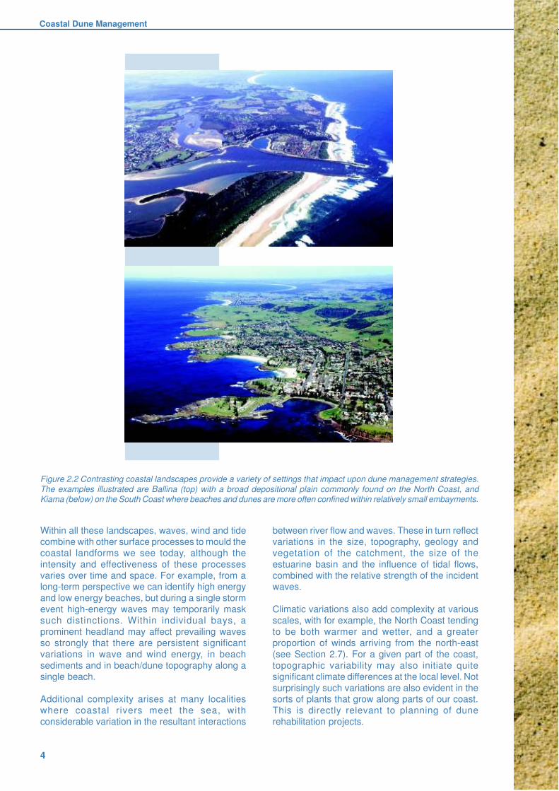
between prominent bounding headlands (Figure2.2). These sorts of distinctions are largely a legacy
of geologic and geomorphic processes that have
been operating for millions of years.
On sandy shorelines, coastal dunes represent the
last line of defence against erosion by providing a
reservoir of sand for waves to utilise during storms.
hind dunes
foredune(frontal dune)
incipient dune
beach berm
tertiary vegetation
zone
secondary vegetation
zone
primary vegetation
zone
berm swashzone
surfzone
nearshorezone
nearshorebar
WIND WAVE
Figure 2.1 Typical features of a dynamic beach system.
Coastal Dune Management
4
Within all these landscapes, waves, wind and tide
combine with other surface processes to mould the
coastal landforms we see today, although the
intensity and effectiveness of these processes
varies over time and space. For example, from along-term perspective we can identify high energy
and low energy beaches, but during a single storm
event high-energy waves may temporarily mask
such distinctions. Within individual bays, a
prominent headland may affect prevailing waves
so strongly that there are persistent significant
variations in wave and wind energy, in beach
sediments and in beach/dune topography along a
single beach.
Additional complexity arises at many localities
where coastal rivers meet the sea, with
considerable variation in the resultant interactions
between river flow and waves. These in turn reflect
variations in the size, topography, geology and
vegetation of the catchment, the size of the
estuarine basin and the influence of tidal flows,
combined with the relative strength of the incidentwaves.
Climatic variations also add complexity at various
scales, with for example, the North Coast tending
to be both warmer and wetter, and a greater
proportion of winds arriving from the north-east
(see Section 2.7). For a given part of the coast,
topographic variability may also initiate quite
significant climate differences at the local level. Not
surprisingly such variations are also evident in thesorts of plants that grow along parts of our coast.
This is directly relevant to planning of dune
rehabilitation projects.
Figure 2.2 Contrasting coastal landscapes provide a variety of settings that impact upon dune management strategies.
The examples illustrated are Ballina (top) with a broad depositional plain commonly found on the North Coast, andKiama (below) on the South Coast where beaches and dunes are more often confined within relatively small embayments.

Dunes and the Coastal Zone
5
Ultimately the combination of all these factors has
resulted in the development of diverse but
characteristic assemblages of coastal plants as well
as the valuable fauna habitats they provide.
Conservation of this biodiversity is a core objective
for coastal dune management.
The challenge is to protect, rehabilitate andrestore coastal dune ecosystems as well as
maintaining the aesthetic and social values of
these landscape components.
2.2 Coastal evolution
To understand present day coastal landscape
features, it is also helpful to take into account the
different conditions that have existed during the
past, particularly the fluctuations in sea level thathave occurred due to global climate change. For
most purposes it is sufficient to go back 120,000
years or so when sea level was possibly a few
metres higher than it is at present and a powerful,
constructive south-easterly swell was the dominant
component of NSW wave climate. At that time
these waves were helping to move large volumes
of sand both alongshore and onshore to form the
mix of beach and dune sands that are preserved
today, at least on the North Coast, as the Inner orPleistocene barrier.
With the onset of the last Ice Age or Glacial, sea
level fell until it was approximately 130 metres below
its present position. This left the Pleistocene barrier
stranded inland and part of the continental shelf
was transformed into a coastal plain. For most of
NSW the coastline was several tens of kilometres
seaward of its present position. Coastal rivers wereflowing out onto the shelf and depending on
catchment characteristics were delivering sediment
to the coastal plain. Coastal headlands were less
prominent, facilitating longshore sediment
transport.
Climatic warming at the end of the Glacial prompted
sea level to rise until about 6500 years ago when it
was close to its present position. The rapid rise in
sea level, in conjunction with the prevailing south-easterly swell regime, prompted more onshore and
longshore movement of large amounts of sediment
to form an Outer or Holocene barrier. These most
recent barriers generally ceased development
around 2000 years ago when transport of sand from
the continental shelf apparently ceased.
As there is little additional sand being supplied to
the coast today, only a relatively small, finite amount
is available to form beaches and dunes. At manylocalities the limited supply of sand, combined with
strong longshore sediment transport, has resulted
in a reversal of the Holocene phase of sediment
accumulation to one where the shoreline is steadily
receding. On much of the North Coast, for example
at Broadwater near Evans Head, waves are now
reworking Inner Barrier sediments.
Many landscape variants have developed within
this very generalised scenario. Thom et al. (1978)
distinguished several different types of barriersbased on their distinctive landforms and underlying
sediments. Subsequent research has attempted to
explain these variations primarily in terms of
sediment supply and embayment and continental
shelf characteristics. At the broadest scale, a much
greater abundance of sediment is thought to explain
the much more prolific and complex barrier
development that has occurred on the North Coast.
2.3 Coastal processes
The prevailing force shaping the NSW coastline is
wave energy. Waves, in conjunction with surf zone
currents are primarily responsible for the recurrent
cycle of erosion and recovery of our beaches.
The NSW wave climate is characterised by a
powerful, constructive southeasterly swell regime.
These high-energy waves are generated by storm
depressions passing to the south of Australia.Larger waves moving northwards into the Tasman
Sea eventually reach the NSW coast after travelling
many hundreds of kilometres. This wave regime is
responsible for producing the depositional
shorelines seen today and for the world-renowned
surfing environment.
Other waves are superimposed on this background
swell. They include waves from the east and north-east generated by tropical cyclones in the Coral
Sea, shorter waves from the same direction
generated by onshore sea breezes, and high
energy storm waves that arrive primarily from the
south. The latter are generated by more localised
storm depressions (East Coast Lows) in the
Tasman Sea. Easterly waves are also generated
by slow-moving Highs in the northern Tasman Sea
(Short 1993).
When data on wave height, period and direction
are combined, it is apparent that deep water waves
from the southeast and south account for
approximately three-quarters of the energy
reaching the NSW coastline.
The tidal regime of the NSW coast is semi-diurnal,
with two high tides and two low tides in just over 24
hours. It is also micro-tidal, with a difference in
elevation between mean low tide and mean hightide of only one metre. Even at Full and New Moon
(Spring tides) the difference is only two metres.

Coastal Dune Management
6
Combined with the relatively steep inshore
gradients this means that wave action is generally
concentrated within a fairly narrow elevational
range.
Waves are crucial in stirring up sand in the
nearshore and in generating currents in the surf
zone. In deep water they have little interaction withthe seabed but as they approach the coast, friction
begins to slow them down and they become
increasingly capable of moving sediment. Variations
in direction of wave approach, combined with
irregularities in sea floor topography results in
refraction or bending of wave crests and this in turn
initiates variations in energy levels received along
a shoreline. At many localities along the NSW
coast, the southern ends of beaches have
significantly lower average wave energy levels thatare matched by narrower surf zones and beaches,
and lower berms and dunes.
On breaking, the waves are able to move sediment
shorewards but they also cause a piling up of water
against the beach called wave setup. This landward
movement of water is balanced by undertow and
rip currents that move sediment seawards beyond
the line of breaking waves. Also, when waves
approach the shore obliquely, longshore currentscan be generated within the surf zone, driving water
and sediment parallel to the shore. The direction
and strength of movement changes according to
the direction of wave approach but on the North
Coast in particular there is a prevailing nett
longshore sediment transport to the north.
During calm weather waves run up the beachface
towards the berm crest (Figure 2.1). However,
under storm conditions the water level adjacent tothe beach can be much higher allowing storm
waves to break further up the beach. This increases
their potential to erode the beach and dunes.
Estuaries also have an influence on sediment
movements in the coastal zone, particularly during
floods when sediment is flushed from coastal rivers
into the nearshore. This sediment is predominantly
fine mud or silt, but marine sand from the lowerportion of the rivers may also be flushed out. After
floods, wave and tide action will move sand back
into the river entrances, but the silt and some of
the finer sands can be carried so far offshore that
they are lost permanently from the contemporary
coastal system.
2.4 Beaches
Beaches are accumulations of wave depositedsediment and for the purposes of this manual,
discussion is necessarily restricted to sand
beaches. On oceanfront beaches in NSW, high
wave energy precludes deposition of very fine
sediments such as silts and clays within the surf
zone. However they are found in some beaches
within sheltered estuarine environments, as well
as in deep water offshore on the continental shelf.
Cobble and boulder beaches are not uncommon
on rocky shorelines but dunes are not developed
from these deposits. Some only become visibleafter very severe storms have stripped away the
beach and dune sands that may overlay them.
Sandy beaches are one component of a larger
dynamic coastal system that begins offshore in
water depths often greater than 20 m and extends
landward to encompass the nearshore bars, the
surf zone, the beaches themselves and the
adjoining dunes. As waves approach the shore from
deep water they progressively interact with the seafloor, slowing down and losing energy. The most
dramatic changes occur in the surf and swash
zones where breaking waves and subsidiary
currents are continually mobilising nearshore and
beach sediments.
Beach changes within this dynamic system are
cyclic. Storm waves move sand from the beach and
dune to build storm bars. Subsequent calm weather
favours onshore movement of the sand tore-establish the beach, and prevailing onshore
winds blow sand beyond the beach where it can
be held by surface vegetation to create stable
dunes. Short-term fluctuations of the shoreline are
often quite dramatic and may mask long-term
accretion or recession that occurs at much slower
rates. The difference between short-term erosion
and long-term recession is illustrated in Figures 2.3
and 2.4.

Dunes and the Coastal Zone
7
Figure 2.4 Long term beach recession - profile displaced landward due
to permanent sand loss.
Figure 2.3 Beach erosion/accretion cycle - no permanent sand loss or
shoreline retreat.

Coastal Dune Management
8
If the losses persistently exceed the gains, then
the depositional shorelines within that compartmentmust recede. This situation prevails at many North
Coast beaches.
For example, recession may result from persistent
landward movement of sand due to dune instability.
Similarly, a shoreline can recede where sediment
inputs are reduced by dredging, sand extraction,
or installation of shoreline structures such as
entrance training walls. Recession could also be
initiated by a prolonged rise in sea level and byincreased storm frequency and intensity. Both these
phenomena are predicted to occur as a
consequence of global warming (the enhanced
Greenhouse Effect).
In contrast, beach systems grow seawards in
compartments where sediment inputs have
substantially outweighed losses. Jetty and
Boambee Beaches at Coffs Harbour and Letitia Spit
at Tweed Heads are examples of where thisphenomenon has occurred since breakwater
construction interrupted longshore sediment
transport, effectively trapping large volumes of sand
within these compartments.
Beach sands vary considerably both in size and
composition. Grain size especially is an important
factor in determining the type of beach that is most
commonly observed at any locality. Quartz is the
most abundant mineral constituent at most NSW
beaches, often making up more than 90% of the
sand grains. These deposits are therefore often
referred to as siliceous sands (see Section 2.6.1).
Calcareous material such as shell fragments is
often an important secondary component and at
some sites close to rich shell sources, it may be
the predominant component. Where high
concentrations of calcium carbonate are also
preserved in nearby dune sands, the resultant high
pH (alkalinity) is a significant factor to be considered
in dune revegetation projects.
Other beach sand constituents include the heavy
minerals such as rutile, zircon and ilmenite. The
large concentrations of these minerals in many
beach and barrier deposits north of Newcastle has
sustained a mineral sand mining industry for several
decades. After severe storms, thin layers of these
dark minerals are often visible in the eroded faces
of beach dunes, and often mantle the back-beach
surface.
Whether long term recession occurs depends
primarily on the state of the sediment budget for a
particular part of the coast. Coastal sediment
compartments can gain and/or lose sediment from
several sources (Figure 2.5).
Figure 2.5 Model sediment compartment showing potential sediment inputs and losses.
wind erosion or wave washover off the beach
rivers and estuariesespecially during floods
dune erosionduring storms
longshore transport into system
onshore transportafter storms
offshore loss throughrips especially duringstorms
longshore transportout of area
biogenicshell
productio
n
biogenicshell
productio
n
artificial sink - mining extraction
artificial source-nourishment
deposition inbays and estuaries
cliff erosioncliff erosion
Dunes and the Coastal Zone
9
Dissipative beaches represent the high-energy end
of this continuum. They are characterised by larger
waves and finer sands with gentle beach and
nearshore gradients, wide surf zones and multiple
nearshore bars. No NSW beaches consistently
match this type although many beaches approach
this state during storms.
Reflective beaches are typically narrow with coarse
sands, steeper gradients and no surf zone or
nearshore bar. They are restricted to low-energy
environments such as sheltered, semi-enclosed
bays or the strongly protected southern ends of
some ocean beaches.
Intermediate beaches are the most common beach
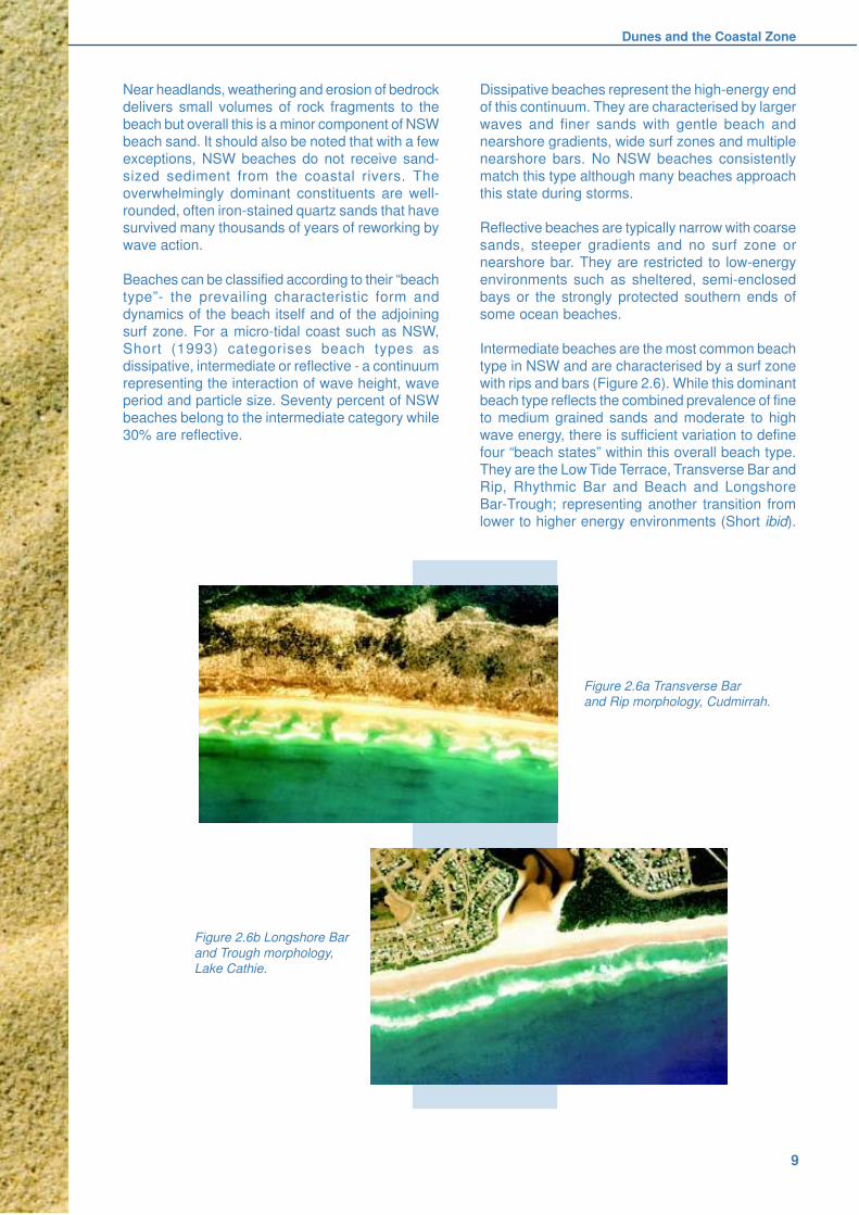
type in NSW and are characterised by a surf zone
with rips and bars (Figure 2.6). While this dominantbeach type reflects the combined prevalence of fine
to medium grained sands and moderate to high
wave energy, there is sufficient variation to define
four “beach states” within this overall beach type.
They are the Low Tide Terrace, Transverse Bar and
Rip, Rhythmic Bar and Beach and Longshore
Bar-Trough; representing another transition from
lower to higher energy environments (Short ibid).
Near headlands, weathering and erosion of bedrock
delivers small volumes of rock fragments to the
beach but overall this is a minor component of NSW
beach sand. It should also be noted that with a few
exceptions, NSW beaches do not receive sand-
sized sediment from the coastal rivers. The
overwhelmingly dominant constituents are well-
rounded, often iron-stained quartz sands that havesurvived many thousands of years of reworking by
wave action.
Beaches can be classified according to their “beach
type”- the prevailing characteristic form and
dynamics of the beach itself and of the adjoining
surf zone. For a micro-tidal coast such as NSW,
Short (1993) categorises beach types as
dissipative, intermediate or reflective - a continuum
representing the interaction of wave height, waveperiod and particle size. Seventy percent of NSW
beaches belong to the intermediate category while
30% are reflective.
Figure 2.6a Transverse Bar
and Rip morphology, Cudmirrah.
Figure 2.6b Longshore Bar
and Trough morphology,
Lake Cathie.
Coastal Dune Management
10
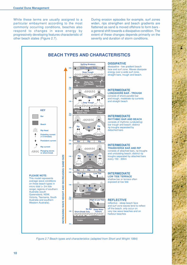
Figure 2.7 Beach types and characteristics (adapted from Short and Wright 1984)
While these terms are usually assigned to a
particular embayment according to the most
commonly occurring conditions, beaches also
respond to changes in wave energy by
progressively developing features characteristic of
other beach states (Figure 2.7).
Spilling Breakers
Outer Breaker Zone
Inner Breaker Zone
Wide, Flat,Firm Beach
Set Up
Set Down
200
200
200
200
200
200
100
100
100
100
100
100
0m
0m
0m
0m
0m
0m
Deep Trough
Bar
Deep Trough
Moderate - SteepBeach Face Cusps
Rip
Rip Rip
Rip
ScarpCusps
Cusps
Bar
Bar
Rip Rip
RipRipBar
High Tide Low Tide
Mini-rip(shallow)
Runnel
ShallowBar
High & Low Tide
No Bar
Shore Break OnlyDeep Water
Inshore
Cusps Berm
BEACH TYPES AND CHARACTERISTICS
DISSIPATIVEdissipative - low gradient beachface and surf zone. Waves dissipateenergy over a wide surf zone,straight bars, trough and beach.
INTERMEDIATELONGSHORE BAR - TROUGHconsists of shore parallel bar and trough, moderate rip currents and straight beach
INTERMEDIATERHYTHMIC BAR AND BEACHconsists of rhythmic (undulating)bar trough and beach; distinctrip troughs separated by detached bars
INTERMEDIATETRANSVERSE BAR AND RIPconsists of attached bars, rip troughsand undulating beach; distinct riptroughs separated by attached barsevery 150 - 300m
INTERMEDIATELOW TIDE TERRACEshallow bar or terrace oftenexposed at low tide
REFLECTIVEreflective - steep beach face and surf zone waves tend to reflect off the beach, only occur on very low wave beaches and on harbour beaches
PLEASE NOTE:This model represents average wave conditions on these beach types in micro tidal (< 2m tide range) regions of southern Australia (southQueensland, NSW, Victoria, Tasmania, South Australia and southern Western Australia).
INC
RE
AS
ING
WA
VE
HE
IGH
T A
ND
DE
CR
EA
SIN
G S
AN
D S
IZE
Bar
Beach
Rip Head
Pulsating current(1-2 minutes)
Persistent current
Rip current
Plunging wavesor shore break
KEY
ShallowBar
During erosion episodes for example, surf zones
widen, rips strengthen and beach gradients are
flattened as sand is moved offshore to form bars -
a general shift towards a dissipative condition. The
extent of these changes depends primarily on the
severity and duration of storm conditions.
Dunes and the Coastal Zone
11
2.5 Coastal Dunes
Coastal dunes are accumulations of wind blown
(aeolian) sand located behind the beach. Near their
seaward margins aeolian deposits are intermixed
with wave deposited beach sands but as distance
from the shore increases, wind action becomes the
dominant force. The nature and extent of dunedevelopment at any location is governed by a
number of factors including the amount and size of
sand currently being supplied to the beach itself,
patterns of wind strength and direction, embayment
topography and orientation, and the type of beach.
Other factors being equal, dissipative beaches with
finer sands and more gentle beach gradients are
more conducive to wind blown sand transport and
growth of dunes.
Typically, an undisturbed beach will be backed by
a foredune (also known as a frontal dune) and hind
dunes. During a prolonged accretionary phase such
as occurred during the 1980s and early 1990s there
might also be an incipient foredune immediately
seaward of the established foredune. An incipient
foredune is a small bench or platform of windblown
sand at the rear of a beach. During accretion
dominant phases these can grow rapidly, both
upwards and seawards and are progressivelycolonised by grasses and creepers. Hesp (1984)
describes several main variations in their method
of establishment. Their seaward margins are
attacked intermittently by storm waves and in major
erosive episodes they are often removed
completely.
Vegetation cover is a crucial element in the
evolution of dune landscapes (see Section 2.8).Wind velocity is generally reduced by plant cover,
encouraging deposition and trapping of wind borne
sand. However it may also accelerate locally in gaps
between plants, especially those having a clumpy
form. Where erect plants like Marram Grass
(Ammophila) or Bitou Bush (Chrysanthemoides)
predominate, a more hummocky dune surface is
likely to develop compared to sites where a carpet
of low, spreading plants like Spinifex or Beach
Morning Glory (Ipomoea) prevail.
The established foredune lies between the incipient
dune and the hind dunes. They are a more massive
and persistent beachscape feature although their
attack by waves during severe or prolonged storm
episodes is a naturally recurring phenomenon.
Their size, shape and stability are also controlled
strongly by vegetation cover. Woody shrubs and
trees typically dominate the seaward and landward
slopes respectively although species can varyaccording to local conditions (see Chapter 6 and
Clarke (1989a) or Chapman 1989). In embayments
that have a limited sand supply or are suffering long
term coastal recession, narrow dune fields are
typical and often consist only of a foredune. In
broad, shallow embayments where there has been
an abundant sand supply, beaches and foredunes
may have formed successively over several
thousand years to form a beach ridge plain. These
ridges lie more or less parallel to the coastline and
may extend several kilometres inland. Plantsuccessions and time-dependent trends in soil
differentiation are well developed on these plains.
Without the stabilising effect of vegetation, sand
is easily moved by the wind and the resultant
sand drift can progressively bury both natural
and built environments. Weakening or
destruction of foredune vegetation can be
induced by natural events such as drought,
lightning-initiated fires or storm waves, and bydisturbance due to a variety of human activities,
including trampling, and introduction of weeds
such as bitou bush.
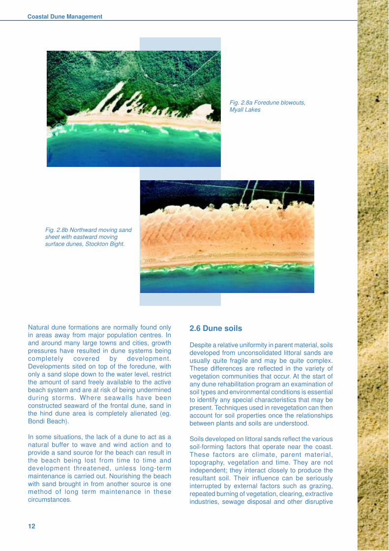
Very localised disruption of vegetation on a
foredune may result in formation of a blowout,
whereby strong onshore winds extend a tongue of
sand inland, beyond the general line of the
remaining vegetated frontal dune (Figure 2.8a). A
blowout is usually “U” shaped and aligned awayfrom the direction of strong winds. When blowouts
form, a lowered section of the foredune acts to
concentrate and funnel wind, increasing its velocity
and its sand transport capacity. Consequently the
blowout becomes deeper and with the gradual
collapse of the sidewalls, it can become a significant
landscape feature as well as a loss to the coastal
sediment compartment.
Some blowouts may extend landward in elongatedfashion bounded by prominent trailing sidewalls -
these features are often referred to as parabolic
dunes. Air photographs of the NSW coast reveal
the presence of older but currently stable, vegetated
parabolic dunes that are indicative of other
episodes of dune sand mobilisation earlier in the
Holocene.
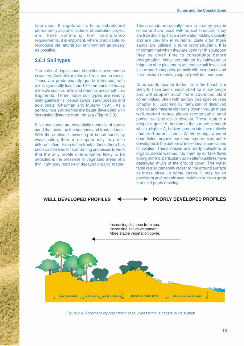
A much greater degree of disturbance may resultin more widespread sand movement and the
development of transgressive dune sheets. These
are very large areas of bare sand upon which a
variety of dunes more commonly found in desert
environments can form (Figure 2.8b). Direction of
sand movement often varies with seasonal changes
in wind direction.
Coastal Dune Management
12
2.6 Dune soils
Despite a relative uniformity in parent material, soilsdeveloped from unconsolidated littoral sands are
usually quite fragile and may be quite complex.
These differences are reflected in the variety of
vegetation communities that occur. At the start of
any dune rehabilitation program an examination of
soil types and environmental conditions is essential
to identify any special characteristics that may be
present. Techniques used in revegetation can then
account for soil properties once the relationships
between plants and soils are understood.
Soils developed on littoral sands reflect the various
soil-forming factors that operate near the coast.
These factors are climate, parent material,
topography, vegetation and time. They are not
independent; they interact closely to produce the
resultant soil. Their influence can be seriously
interrupted by external factors such as grazing,
repeated burning of vegetation, clearing, extractive
industries, sewage disposal and other disruptive
Natural dune formations are normally found onlyin areas away from major population centres. In
and around many large towns and cities, growth
pressures have resulted in dune systems being
completely covered by development.
Developments sited on top of the foredune, with
only a sand slope down to the water level, restrict
the amount of sand freely available to the active
beach system and are at risk of being undermined
during storms. Where seawalls have been
constructed seaward of the frontal dune, sand inthe hind dune area is completely alienated (eg.
Bondi Beach).
In some situations, the lack of a dune to act as a
natural buffer to wave and wind action and to
provide a sand source for the beach can result in
the beach being lost from time to time and
development threatened, unless long-term
maintenance is carried out. Nourishing the beach
with sand brought in from another source is onemethod of long term maintenance in these
circumstances.
Fig. 2.8b Northward moving sandsheet with eastward moving
surface dunes, Stockton Bight.
Fig. 2.8a Foredune blowouts,
Myall Lakes
Dunes and the Coastal Zone
13
land uses. If vegetation is to be established
permanently as part of a dune rehabilitation project
and have continuing low maintenance
requirements, it is important, where practicable, to
reproduce the natural soil environment as closely
as possible.
2.6.1 Soil types
The soils of depositional shoreline environments
in eastern Australia are derived from marine sands.
These are predominantly quartz (siliceous) with
minor (generally less than 10%) amounts of heavy
minerals such as rutile and ilmenite, and small lithic
fragments. Three major soil types are readily
distinguished - siliceous sands, sand podsols and
acid peats (Charman and Murphy 1991). As a
general rule soil profiles are better developed withincreasing distance from the sea (Figure 2.9).
Siliceous sands are essentially deposits of quartz
sand that make up the beaches and frontal dunes.
With the continual reworking of beach sands by
wave action, there is no opportunity for profile
differentiation. Even in the frontal dunes there has
been so little time for soil forming processes to work
that the only profile differentiation likely to be
detected is the presence in vegetated areas of athin, light grey horizon of decayed organic matter.
These sands are usually fawn to creamy grey in
colour and are loose with no soil structure. They
are free draining, have a low water holding capacity
and are very low in nutrients. Quite often these
sands are utilised in dune reconstruction. It is
important that when they are used for this purpose
they be given time to consolidate before
revegetation. Initial percolation by rainwater orirrigation after placement will reduce salt levels but
as the sand compacts, porosity will be reduced and
the moisture retaining capacity will be increased.
Dune sands located further from the beach are
likely to have been undisturbed for much longer
and will support much more advanced plant
communities, often with tertiary tree species (see
Chapter 6). Leaching by rainwater of dissolved
organic and mineral elements down through thesewell-drained sands allows recognisable sand
podsol soil profiles to develop. These feature a
deeper organic A1 horizon at the surface, beneath
which a lighter A2 horizon grades into the relatively
unaltered parent sands. Within young, wooded
dune fields, organic horizons may be even better
developed at the bottom of inter-dunal depressions
or swales. These basins are ready collectors of
organic debris washed into them by surface flows
during storms, particularly soon after bushfires havedestroyed much of the ground cover. The water
table is also generally closer to the ground surface
at these sites. In some cases, it may be so
persistent and organic accumulation rates so great
that acid peats develop.
Figure 2.9 Schematic representation of soil types within a coastal dune system
Increasing distance from sea.Increasing soil development.More stable vegetation cover.
WELL DEVELOPED PROFILES POORLY DEVELOPED PROFILES
sand podsols sand podsolsacid peats siliceous dune sand
Coastal Dune Management
14
Where good drainage exists however, and sufficient
time has passed for substantial woody vegetation
cover to become established, the profiles of sand
podsols become more differentiated. These are
also acidic soils but have been subjected to stronger
or more persistent leaching. A grey organic surface
A1 horizon is easily recognised, beneath which a
whitish A2 horizon more sharply overlies an orange
coloured B2 horizon (Figure 2.10).
Sharpest profile differentiation is evident where
Pleistocene Inner barrier sands are present. At
these sites there are usually very sharp boundaries
between soil horizons and the colour differences
are quite stark. Most obvious is the white, bleached
A2 horizon; at some sites the silica concentrations
are so pure and so thick, that they are mined to
produce glass. Underlying B2 horizons are typically
dark brown, containing high levels of organic
colloids and iron oxides known as humate. Often,
fluctuating water tables can produce such high
concentrations that the uppermost part of the B2
becomes cemented into an indurated (hardened)
pan known colloquially as coffee rock.
These hardpans inhibit water infiltration, affect
water table levels and restrict root and air
penetration. At disturbed sites where the overlyingA horizons have been eroded or removed,
revegetation can only be undertaken successfully
if the pan is deep ripped and then covered with
300mm to 500mm of unconsolidated sand.
Within each of these major groupings there are
innumerable minor variations in the physical and
chemical characteristics of the soil. These result
from differences in the soil forming factors such as
elevation, drainage, slope gradient, aspect,distance from the sea, texture and composition of
parent sands, vegetation cover, and the effects
these have on leaching and the mobility of organic
and mineral ions within the sand mass. These
differences in turn generate differences in pH,
fertility, moisture retention capacity and erodibility,
all of which combine to support vegetation
communities of varying floristic composition and
structure.
Exceptions to the generality of Figure 2.9 should
also be acknowledged. For example on a receding
coastline undifferentiated siliceous sands may
directly overlie well-developed podsols. The
Department of Land and Water Conservation has
prepared Soil Landscape Maps with
comprehensive accompanying notes for many parts
of the NSW coast. These provide valuable
descriptions of soil, vegetation and landformassemblages.
Figure 2.10b Strongly differentiated podsol in Inner Barrier
dune sand (>50,000yrs). Note the sharp boundary between
the bleached A2horizon and the underlying B horizon which
is enriched with organic matter and iron oxide.
Figure 2.10a Immature sand podsol in
Outer Barrier dune sand (c.2000 yrs)
with little profile differentiation.
Dunes and the Coastal Zone
15
is more relevant. In addition to inherent erodibility,
other site characteristics such as slope length, slope
steepness and vegetation cover are used to predict
the likelihood of erosion (erosion hazard).
Coastal sand dunes, by virtue of their mode of
formation and their position, are susceptible to wind
erosion. Grains are readily detached from eachother and their shape, size and density aid
movement by the wind. Sand drift resulting from
wind erosion can cause considerable economic and
environmental damage (Figure 2.11).
Figure 2.11 Sand drift at Anna Bay near Newcastle
threatens both built and natural environments.
In contrast, unconsolidated dune sands, despite
their non-cohesive nature, are not generallyconsidered at risk of water erosion as their high
water absorptivity reduces runoff and removes the
potential for transport of detached grains.
However, at locations such as stormwater outlets,
where large volumes of water are diverted to dune
areas, the risk increases markedly since the
infiltration capacity of the surface is readily
exceeded. Runoff from concrete paths and car
parks with impervious surfaces can have similareffects.
2.6.2 Soil characteristics
Particle size, moisture retention anddrainage
Most NSW coastal sands are fine to medium
grained. At most sites, they are well sorted, with a
relatively small range in particle size. Porosity istherefore quite high, which limits moisture retention
capacity. In deep foredune sands, the high
percentage of pore space facilitates free drainage,
with any salt or nutrients present at the surface
being readily leached down through the sand mass.
As vegetation becomes established, organic matter
from the vegetation and associated fauna is
incorporated into the surface of the soil. Moistureholding capacity is closely dependent on organic
matter content and as time progresses, organic
matter builds up and moisture-holding capacity
increases. As a general rule, soils low in organic
matter will also generally dry out more quickly. This
has important implications for revegetating dune
soils. Older dune soils have developed under
vegetation over a longer period of time than younger
sands to seaward and therefore have a higher
moisture retention capacity. Field moisture capacitymay vary from 7 per cent (by volume) in young dune
sand to 33 per cent in old dune sand.
Soil Fertility
Soil fertility is governed by two factors: physical
factors such as water availability, air porosity and
structural strength, and chemical factors such as
pH, nutrient availability, salinity and organic content.
Dune soils are generally considered to have low
fertility. Their fertility decreases as the depth from
surface organic layers increases. This restricts plant
roots to the top horizons of the profile and increases
the plant’s reliance on frequent rainfall or on
moisture stored by organic matter.
Although dune plants are well adapted to growing
in low nutrient soils, and a few species may even
be harmed by the application of inorganic fertiliser,revegetation programs generally benefit from the
addition of fertilisers and mulch to assist in plant
establishment and growth. The types and
application rates of fertiliser used are discussed in
Chapter 6.
Erodibility and erosion hazard
Erodibility is an intrinsic property of soil materials
and refers to their potential for erosion. Graindetachability is the major determinant. For water
erosion, moisture absorptivity is also an important
factor whereas for wind erosion, surface roughness
Coastal Dune Management
16
Erosion control
Control of wind erosion on coastal dunes relies
primarily on maintaining a uniform protective cover
of suitable vegetation. Mulch, synthetic aggregates
or access control structures such as board and
chain walkways can also limit wind erosion.
Impermeable surfaces that generate water runoff
such as concrete paths, hard-topped roads and car-
parking areas create management issues that need
careful consideration. As a general rule flexible
absorbent surfaces that are harmonious with
unconsolidated sand are recommended for use in
dune areas. Note that vegetation does not remove
the hazard of stormwater erosion; developments
must not concentrate stormwater runoff on dunes.
Stormwater should be directed via erosion resistantsurfaces to detention basins or other storage and
treatment facilities (NSW Department of Housing
1998).
2.7 Climatic influences
Climate plays a crucial role in coastal landscapes
generally and through wind, air temperature and
rainfall it impacts either directly or indirectly oncoastal dunes. Although the NSW coastal climate
is generally temperate due to the moderating
influence of the Tasman Sea, climatic parameters
vary appreciably from North to South (Figures 2.12,
2.13, 2.14) and this has implications for dune
stabilisation and rehabilitation projects. This is
especially true for vegetation cover, with prevailing
climatic conditions dictating both the naturally
occurring range of plant species and the survival
and growth of rehabilitation plantings. Additionalclimatic variability is also imparted by localised
factors such as topography.
2.7.1 Wind
Wind directly influences waves, currents, water
levels and sand transport and thereby moulds many
coastal features into shapes that reflect wind
strength, direction and duration. Coastal dunes are
a specific expression of local winds. Local windpatterns also play a critical role in dune rehabilitation
through their effect on plant establishment and
survival.
The NSW coastline experiences an annual wind
regime that features several distinct components.
These result from the persistent west to east
passage of High and Low pressure cells across
Australia and the seasonal variations in their
tracking latitude. The latter facilitate the ingress ofwarm, moist tropical air masses during summer and
incursions of cold Southern Ocean air during winter.
In addition, localised differential heating of the land
and sea generates onshore afternoon sea breezes
and cool offshore early morning land breezes.
Figure 2.12 uses wind roses to illustrate the
seasonal wind patterns for three stations on the
NSW coast. The length of each bar on any wind
rose is proportional to the frequency with which windarrives from the nominated direction. The widths
of the bar segments indicate wind strength. The
diameter of the central circle in each wind rose is
proportional to the frequency of calms.
It should be noted that these are long-term average
values and that in any year there can be significant
departures from the general patterns. Only
afternoon values are shown as this is the time of
day when winds are often strongest. Long termevening wind data are generally unavailable and
while winds generally drop at night, strong storm
winds that occur at that time escape inclusion in
wind averages.

Dunes and the Coastal Zone
17
It is also emphasised that the selected stations areindicative only. Other localities, even those close
to the selected ones may experience different
conditions. The Cape Byron station for example is
located at a very exposed site 95m above sea level,
on a headland that protrudes seawards well beyond
the general line of the adjoining coast.
Winds are generally weaker during the morning and
commonly blow offshore. Wind strengths increaseduring the day, typically to a late afternoon peak.
Cape Byron is noticeably more windy overall (due
in part to the elevation of the recording station) than
the Central or South Coast.
Overall the stronger, more persistent winds arrive
from the SE or NE. Because of the general
alignment of the NSW coast this means that winds
are usually onshore and this is reflected in the
orientation of most foredune blowouts (eg. Figure2.8a). This has implications for dune accessway
alignments (see Section 4.7.3).
The wind rose suggests that southeasterly andsoutherly winds are important throughout the year
at Cape Byron and Sydney respectively, but not as
significant at Merimbula. It should be noted however
that the Merimbula airport station is sheltered from
southerly winds and the wind rose for that location
may indicate a deceptively high proportion of
northeasterly winds as a result.
Winds with a westerly component are generallymore common during Winter and Spring when the
anticyclones are following their northernmost tracks.
They can be a seasonally important mobilising force
on larger sand masses, such as at Stockton Bight
on the central coast.
There are significant localised departures from
these generalised patterns of wind and
shoreline interaction. They result from
variations in coastal alignment and topographyand need to be incorporated in planning any
dune rehabilitation project.
Figure 2.12 Seasonal wind roses showing afternoon wind patterns at three stations on the NSW coast(Original data courtesy Commonwealth Bureau of Meterology)
Cape
Byron
Sydney
Airport
Merimbula
Airport
Summer Autumn Winter Spring
LEGEND:
3pm
NWN
Calm
NE
E
SES
SW
WCalm
km/h
1-10 11-20 21-30 31-40 >40 20%
25%Calms
Coastal Dune Management
18
2.7.2 Rainfall
Rainfall along the NSW coastline varies in both
amount and distribution. Average annual rainfall
increases northwards, from around 750mm in the
south to over 1900mm in the north. Byron Bay for
example has an average annual rainfall of 1910
mm compared to 860mm at Eden (Figure 2.13).This is primarily a response to the moisture input
from tropical air masses. At most localities rainfall
is distributed fairly evenly throughout the year,
although small late summer/autumn maxima are
evident north from Sydney.
Rainfall is an important consideration for dune
management as the higher and more reliable the
rainfall, the greater the opportunity for vegetativegrowth to occur and for revegetation to succeed.
Again, changes over time need to be taken into
account, as prolonged periods of less than average
rainfall are common and additional watering of
newly established plants may be required.
Prolonged dry periods also leave vegetation more
susceptible to fire.
Figure 2.13 Variation in mean monthly rainfall along the NSW coast.(Original data courtesy Commonwealth Bureau of Meteorology)
DEC JAN FEB MARAPR
MAYJUN
JULAUG
SEPOCT
NOV
MERIMBULA
SYDNEY
CAPE BYRON
0.0
50.0
100.0
150.0
200.0
250.0
Rain
fall
(m
m)
Month

Dunes and the Coastal Zone
19
2.7.3 Temperature
Temperature also varies along the NSW coast
(Figure 2.14). Both average monthly minimum and
maximum temperatures increase northwards with
mean monthly maximums at Cape Byron three to
four degrees warmer than at Merimbula.
Temperatures peak in January/February while the
coldest month is July, when frosts have been known
to occur within grassed areas of foredunes on the
Far South Coast. The daily temperature range is
also greater in the south.
Temperature governs the time of year when dunes
can be replanted. While there are grasses that can
be planted throughout the year, the cooler
conditions of autumn and winter are preferred forplanting of shrubs and trees, since these enable
the water requirements of young plants to be better
met at this critical time.
Cooler temperatures in the south also result in later
flowering times for many plants and thereby affect
the timing of seed collection. Seasonal temperature
extremes should also be taken into account when
scheduling rehabilitation project work that requires
hard manual labour, especially where volunteersare involved.
2.8 Vegetation, ecosystems andbiodiversity
Native coastal vegetation is well adapted to
withstand harsh conditions such as strong wind,
salt spray and sand drift. For example, growth of
some plants such as Spinifex (Spinifex sericeus)
and Beach Fescue (Austrofestuca littoralis) isactually stimulated by sand accretion, while others
such as Coastal Wattle (Acacia sophorae) can
withstand slow, partial burial by developing roots
on buried branches. However on highly mobile
dunes, vegetation is lost as the dune moves and
buries it. Loss of sand from the root area is generally
fatal, and is a major cause of decline in dune
vegetation.
Low nutrient levels have led to other adaptations.
Plant leaves for example are very efficient collectors
of salt spray. Coastal Banksia (B. integrifolia) has
masses of fine proteoid roots that are very efficient
in collecting whatever phosphorus is available,
while Coastal Beard Heath (Leucopogon
parviflorus) has bacteria growing in its root area
that serve the same purpose. Peas and wattles can
fix atmospheric nitrogen with the aid of bacteria in
root nodules. Most plants grow in association withmycorrhizal fungi. These fungi act as extensions
of the root systems and greatly enhance the ability
of plants to use scarce soil nutrients.
Figure 2.14 Variation in mean monthly coastal temperatures(Original data courtesy Commonwealth Bureau of Meteorology)
Dec Jan Feb Mar Apr May Jun Jul Aug Sep Oct Nov
Month
30
25
20
15
10
5
0
Tem
pera
ture
CO
Cape Byron Max
Cape Byron Min
Sydney Max
Sydney Min
Merimbula Max
Merimbula Min
Legend:
Coastal Dune Management
20
Figure 2.15 Vegetation zonation and canopy streamliningon different beach-foredune topography. Front Beach,
South West Rocks (top) and Narrawallee (below)
An analogy can be drawn between the protectionafforded by a well vegetated dune system and that
of a well constructed and maintained cyclone-proof
house. Primary zone species (grasses and
creepers) colonise lower parts of the beach and
trap abrasive sand particles forming a “foundation’’.
The foredune represents an elevated “wall” that can
be colonised by secondary zone species (mainly
shrubs) to provide a wind deflecting “shutter” near
the shoreline. Finally a “roof” forms from the growth
of tertiary species (taller shrubs and trees), furtherelevating the wind and providing increased shelter
to vegetation further inland. When exposed to
persistently strong, salt-laden winds, remarkably
streamlined canopy surfaces often develop (Figure
2.16).
The effectiveness of dune plants in stabilising
dunes and resisting erosion has traditionally been
seen as their main value. This perception has arisen
primarily from the property losses and damage due
to sand drift and later from recognition of the impact
of unstable dunes on coastal sediment budgets and
shoreline stability.
Dune vegetation is recognised widely as an
integrated botanical system exhibiting
interdependence in both community structure
and floristics and providing food and shelter
for a variety of fauna. The need to protect,
maintain and restore these intrinsic ecosystem
values is a key element in conserving
biodiversity.
Conservation of biodiversity is a fundamentalprinciple of ESD and provides one of the foundation
stones upon which the NSW Coastal Policy was
developed (NSW Government 1997). The priorities
and actions for conserving biodiversity are
described in the NSW Biodiversity Strategy (NSW
National Parks & Wildlife Service 1999).
Successful implementation of this strategy
specifically requires management of threatening
processes by identifying, preventing and mitigatingthe causes of biodiversity loss. In the coastal dune
environment this includes minimising modification
of natural ecosystems, minimising habitat loss, and
improving fire, weed and pest animal management.
Ecosystem rehabilitation and conservation of
biodiversity are integral components of
contemporary dune management.
2.8.1 Vegetation zonation
At localities where dune vegetation has not been
disturbed significantly by human activity, distinctive
plant zonation is routinely observed, irrespective
of topographic differences (Figure 2.15). This plant
zonation or succession reflects the progressively
more sheltered environments that are created with
increasing distance from the shoreline.
Although it is a continuum extending landward from
the backbeach, three plant zones are usually
recognised: primary, secondary and tertiary.
Reproduction of this succession is a primary
objective of revegetation projects (see chapter 6).
Dunes and the Coastal Zone
21
Figure 2.16 Functional model of dune vegetation - streamlining: analagous to a storm proof house.
Tertiary Vegetation:A roof of interlocking tilesof the permanent canopy.
Secondary Vegetation:The storm shutter.
Dune wall provideslateral shelter
Primary Vegetation: The foundation - gives stability to build on.
As wind is deflected over the vegetation, sand is trapped on incipient or frontal dune.
hind dunes
foredune
incipient dune
Tertiary Vegetation: a roof of interlocking tilesof the permanent canopy.
Secondary Vegetation:The storm shutter.
Dune wallprovideslateral shelter
Primary Vegetation: The foundation - gives stability to build on.Primary Vegetation: The foundation - gives stability to build on.
Wind
Wind
Wind
Wind
beach berm

Coastal Dune Management
22
While well adapted to withstand harsh conditions,
native coastal vegetation is also fragile and easily
damaged. Dune stability relies on keeping the
whole structure - “foundations”, “wall”, “shutter” and
“roof” - intact. Damage to any component can cause
deterioration in other parts.
While the vegetation pattern described aboveoccurs along the entire coast, the plant species
contributing to it vary, primarily as a response to
temperature variations. For example, Spinifex
occurs right along the coast within the grass and
creepers that characterise the incipient foredunes.
However on the North Coast it is accompanied by
Beach Morning Glory, whereas on the South Coast
Beach Fescue is its partner.
Even greater variation in species prevalence occurson the foredune and beyond as climatic and
topographic controls interact in a much more
complex manner (see Chapter 6). Significant
variations may also occur within individual
embayments. For example littoral rainforest species
may only occur in a very small area where the
combination of topography and climate provides a
suitable environment.
Plants also provide habitat for a diverse range offauna, from invertebrates (eg. worms, insects and
crabs) through to reptiles (eg. skinks, snakes and
goannas) and to birds and mammals. Like plants,
the animal species occupying particular habitats
also vary geographically.
2.8.2 Biodiversity
Biodiversity is the variety of all species of livingorganisms (plants, animals and micro-organisms),
the genes they possess and the ecosystems they
form. It is usually considered at three levels: genetic
diversity, species diversity and ecosystem diversity
(Commonwealth of Australia 1996).
Biodiversity provides all our food and the raw
materials for a wide range of products including
clothing and medicinal goods and the means to
control pest plants, animals and diseases. It ishighly valued for aesthetic, scientific, recreational
and cultural reasons.
Australia is one of the most biologically diverse
countries on earth with more than one million
species of plants and animals estimated to occur.
A large number of species is found nowhere else
and there is a wide range of ecosystem types. This
biodiversity combines with landscape to impart a
special character of the coastal zone, producingan environment with which many Australians
identify.
Biodiversity is threatened. Within NSW over 80
species of plants and animals are extinct and over
600 species are considered endangered or
vulnerable. The main threats to biodiversity in the
coastal zone are:
n the loss and fragmentation of habitat
through clearance of native vegetationn impacts of human activities on soil and
water
n pressures caused by increasing population
growth
n impacts of weeds and feral animals and
n inappropriate fire regimes
Protection of biodiversity requires consideration of
an ecosystem as a whole; how different species
interact with other species, with the non-livingenvironment and with other ecosystems. For
example, although many animals have fairly
localised habitats, their mobility generally imparts
complexity to dune ecosystems.
Ghost crabs establish deep burrows above high
water mark on the backbeach and incipient
foredunes, but feed on the open lower beach at
night. Seabirds such as dotterels and pied
oystercatchers commonly feed at the waterline butalso fossick and roost above the high water line
amongst the spinifex. Birds, reptiles and mammals
that usually reside in dune scrub or woodlands often
fossick amongst the grasses of incipient foredunes
(Figure 2.17).
Figure 2.17 Dunes provide food and shelter for a variety
of fauna including some listed as Threatened Species.

Dunes and the Coastal Zone
23
Mutton bird carcases along the strandline provide
seasonal feasts for ravens that normally reside in
the wooded areas beyond the foredune. Dead
plants and animals also support decomposing
bacteria and soil microfauna at the lower end of
this coastal food chain.
It is important to recognise the links betweenthe dune ecosystems and those of other coastal
landscapes nearby. Beaches and dunes may
host fauna that visit from nearby headlands,
rock platforms and wetlands as they seek food
and nesting material or take refuge during fires.
The converse also occurs.
Coastal heaths for example, provide habitat for
endangered species and are also important for
migratory and nomadic nectar and insect feedingbirds because they contain many plants that flower
in autumn and winter, thereby providing a food
resource generally unavailable elsewhere.
Clearly, disturbance of the foredune environment
impacts adversely on both flora and fauna, with
the potential to disrupt or destroy sensitive
ecosystems. Littoral rainforests for example have
suffered to the extent that remnants are now
protected by State Environmental Planning Policy26. Some individual plant and animal species are
threatened with extinction and are protected by
legislation. Examples include a Coastal Spurge
(Chamaesyce psammogeton) and the Little Tern
(Sterna albifrons); Species Recovery Plans are
gradually being prepared for those at greatest risk.
Figure 2.18 Chamaesyce psammogeton is classified as
Endangered. It is threatened by storm waves,
pedestrians, vehicles and Bitou Bush.
The return of native fauna to revegetated dunes is
a rewarding indicator of an ecologically successfulrehabilitation project.
2.9 Fire management
Naturally occurring fires are not considered to be a
regular feature of the coastal dune environment.
Relatively low fuel levels, humid conditions and
absence of ignition sources preclude fires occurring
in most circumstances. Most dune vegetation
species are able to reproduce themselves in theabsence of fire, and the development of littoral
rainforests in hind dune areas indicates prolonged
fire free periods.
All natural areas have a fire regime to which the
native plants and animals have adapted over a long
period. The fire regime for any one location is made
up of three components, how often it is burnt
(frequency), how hot (intensity and duration) and
what time of year (season). Varying any one ofthese factors will produce changes in the plants
and animals which occur at that location.
Some dunal areas appear to have been burnt too
frequently with consequent changes in the
vegetation and loss of species. Dune areas with
thick swards of Blady Grass (Imperata cylindrica
var major) and/or Bracken Fern (Pteridium
esculentum) and an absence of trees such as
Coastal Banksia can indicate a pattern of overfrequent burning. Removing vegetation cover can
also lead to dune instability and assist weed
invasion.
It is recognised that active fire management may
be required to reduce the risk of wildfire to life and
property that has been built in the dune
environment. Fire protection measures need to
balance the requirements for hazard reduction andenvironmental protection. Any fire protection
measures are required to be identified in bushfire
risk management plans, and only measures
approved in these plans are permitted.
While many strategies are available and will
necessarily vary with local circumstances, both
objectives can usually be met. This may mean
establishing fuel free and/or fuel reduced zones
immediately adjacent to property as opposed torepeated burning of larger areas. Construction of
fire trails needs special consideration due to
environmental and safety problems and should be
avoided wherever possible.

Coastal Dune Management
24
2.10 Overview
This chapter has presented an overview of the
NSW coastal environment; how it has evolved; the
character of the main landscape elements
especially the beaches and coastal dunes, the soil
and vegetation assemblages they support and the
environmental factors and processes controlling thediversity of these. Readers interested in further
detail about any aspect are directed to the
recommended references.
The first point to emphasise is that all the nominally
discrete components of this complex coastal
environment are part of an integrated biophysical
system. They are all linked directly or indirectly with
varying degrees of interdependency. Interference
in one part of the system will initiate change(s)elsewhere. Some changes may be immediate and
dramatic; others may have no obvious immediate
consequence but may contribute to significant
cumulative impact in the longer term.
The second major point is that successful dune
rehabilitation projects need to acknowledge the
dynamic nature of the coastal environment. Severe
storms periodically erode foredunes, incipient
foredunes are often removed completely, and it islikely that climate change will initiate more frequent
disturbances of this nature. Recovery prompts
changes too, but as a longer term phenomenon, it
can generate a false sense of security amongst
the unwary.
The third major point is the need to acknowledge
the impacts of human activities. While many of
these impacts are no longer accepted by many intoday’s society, dune rehabilitation cannot be
undertaken successfully without addressing human
needs and aspirations. The next chapter therefore
reviews the social and cultural values of the coastal
beach and dune environment so that they can be
accommodated appropriately in future
management programs that embrace the principles
of Ecologically Sustainable Development.

Dunes and the Coastal Zone
25
2.11 References and further reading:
Carolin R. and Clarke P. 1991, Beach Plants of South
Eastern Australia, Sainty & Associates.
Carter R.W.G. and Woodroffe C.D. (eds) 1994,
Coastal Evolution: Late Quaternary shoreline
morphodynamics, Cambridge University Press.
Charman P.E.V. and Murphy B.W. (eds) 1991, Soils:
Their Properties and Management - A Soil
Conservation Handbook for New South Wales, SoilConservation Service of New South Wales and Oxford
University Press, Sydney.
Chapman D.M., Geary M., Roy P. and Thom B.G.
1982, Coastal Evolution and Coastal Erosion in New
South Wales, Coastal Council of NSW, Sydney.
Chapman D.M. 1989, Coastal Dunes of New South
Wales Status & Management, University of Sydney
Coastal Studies Unit Technical Report No. 89/3.
Clarke P.J. 1989a, Coastal Dune Vegetation of New
South Wales, University of Sydney Coastal Studies
Unit Technical Report No. 89/1 & Soil Conservation
Service of New South Wales Tech. Rep. No. 21.
Commonwealth of Australia 1996, The National
Strategy for the Conservation of Australia’s Biological
Diversity, Commonwealth Department of Environment,
Sport and Territories, Canberra.
Davies J.L. 1980, Geographical Variation in CoastalDevelopment, Longman, New York, 2nd edition.
Hesp P.A. 1984, Foredune Formation in Southeast
Australia, Ch4 in Thom B.G. (ed) Coastal
Geomorphology in Australia, pp 69-98.
NSW Department of Housing 1998, Managing urban
stormwater: soils and construction, Department of
Housing, Sydney.
NSW Government 1990, Coastline ManagementManual, Sydney.
NSW Government (in preparation), Coastal Zone
Management Manual, Sydney.
NSW National Parks and Wildlife Service 1999, NSW
Biodiversity Strategy, NPWS, Hurstville.
Roy P.S., Zhuang W-Y., Birch G.F., Cowell P.J. and
Congxian Li 1997, Quaternary Geology of the Forster-
Tuncurry Coast and Shelf, Southeast Australia,Geological Survey of New South Wales, Department of
Mineral Resources, Sydney.
Short A.D. 1979, Three Dimensional Beach-Stage
Model, J. Geology, 87 pp 553-571.
Short A.D. 1993, Beaches of the New South Wales
Coast: A guide to their nature, characteristics, surf and
safety, Coastal Studies Unit, University of Sydney andSurf Life Saving New South Wales Inc., Sydney.
Short A.D. and Wright L.D. 1984, Morphodynamics of
High Energy Beaches: An Australian Perspective, Ch3
in Thom B.G. (ed) Coastal Geomorphology in
Australia, pp 43-68.
Thom B.G., Polach H.A. and Bowman G.M. 1978,
Holocene age structure of coastal sand barriers in New
South Wales, Australia, Rept. Dept. of Geography,
Faculty of Military Studies, University of NSW,Duntroon A.C.T.
Thom B.G. (ed) 1984, Coastal Geomorphology in
Australia, Academic Press, North Ryde, Sydney.
Thom B.G., Shepherd M., Ly C.K., Roy P.S. Bowman
G.M. and Hesp P.A. 1992, Coastal Geomorphology
and Quaternary Geology of the Port Stephens-Myall
Lakes Area, Department of Biogeography and
Geomorphology Monograph No. 6, ANU Press,
Canberra.
Underwood A.J. and Chapman M.G. (eds) 1995,
Coastal Marine Ecology of Temperate Australia,
University of New South Wales Press, Sydney.

Coastal Dune Management
26

Dunes and People: Planning for working on the dunes
27
3. DUNES AND PEOPLE:Planning for working onthe dunes
3.1 Introduction
While coastal dune systems have experiencedrecurring periods of natural stability and instabilityfor thousands of years, present day instability atmany sites is due primarily to human impacts atvarying scales.
The NSW Coastal Policy (NSW Government1997) states clearly that only developmentswhich do not compromise the natural andcultural values of an area should be permittedon beaches and foredunes. It envisages onlydevelopments for essential public purposes.
However, there is still a wide range of other humanactivities that threaten these fragile landforms andtheir vegetation. The dilemma for coastal managersis that although dunes are extremely fragilelandforms, they are an integral part of anincreasingly popular community resource.
These demands can only grow as populationgrowth, combined with new recreational pursuitsreinforces traditional affinities for the beach.Accordingly, this chapter begins by identifying themain human interests and activities that may needto be considered when planning a dunerehabilitation project. This sets the scene fordeveloping another of the major themes of thismanual - the value of planning.
A carefully developed plan should lay thefoundation for achieving successfulrehabilitation and at the same time help toresolve conflicting expectations. An ad hocapproach may not achieve lasting benefits.
The principles addressed in this chapter arerelevant to both government and community dunerehabilitation projects, and complement materialcontained in the booklet Volunteers Working on theCoast (DLWC 1997). The practicalities are reviewedprimarily to assist community groups, but they arealso relevant to council and state agency projectswhere active community involvement is likely.Discussion also seeks to improve all landmanagers’ awareness of how some aspects ofcurrent management systems can frustratecommunity group enthusiasm for environmentalrehabilitation.
3.2 Potential beach users andconflicting values
Use of beachfront land is likely to be the object ofdisparate views within a community. In planning anyrehabilitation project it is essential to identify thedifferent social and cultural values assigned to thebeach system by a wide range of human users. Ifthese values are not addressed properly then theproject is almost guaranteed to face ongoingdifficulties with less likelihood of success.
While most people will value a coastal area highly,their expectations may still conflict. For example,residents living adjacent to coastal dunes oftenincorrectly regard them as an extension of their ownproperties. The need to rehabilitate degraded nativevegetation may be perceived by some as a potentialthreat to their use of the area. Successfulrevegetation also has the potential to restrict views.Alternatively, the land may have considerablecultural or spiritual value for local Aboriginal peopleas well as commercial development potential.
Broader community interest in rehabilitation andmanagement of a coastal reserve will impact uponall these perceptions. This may result in real andunwelcome constraints such as restricted beachaccess or the exclusion of companion animals.
In short, people can assign different values tothe same piece of land. Recognition of thesedifferences is essential in minimising oravoiding conflict and encouraging communitysupport for a project.
At the very least, residents and beach users needto be assured in their own minds that their needshave been carefully addressed. Where these havebeen judged incompatible with dune rehabilitationobjectives, it is important that they understand whythat position has been adopted.
Interested parties and activities that may needconsideration at a nominated site include:
n the Land Manager (Council, DLWC, NPWSor private owner)
n general beach users (sunbathers, swimmersand surfers, including residents and visitors)
n owners of adjoining landn indigenous people, either through active use
of the site, or through a passive spiritual linkn surf Life Saving Clubs (patrols, rescue,
training and competition)n specialised recreational users (sailboarding,
surf kites, jet skis, nude sunbathing, hanggliders landing from adjoining headlands)
n recreational and commercial fishers (beachhauling)
n off-road recreational vehiclesn commercial developmentn commercial activities (horse and camel
rides, eco-tours etc)

Coastal Dune Management
28
3.2.1 Indigenous aspects
Indigenous groups have traditionally lived and
travelled along the coast for thousands of years.
Their activities have included habitation, food
gathering and hunting (especially fishing), burial
sites and ceremonies. Coastal middens are the
most common evidence of indigeneous use andoccupation. Many areas are regarded as sacred
and include ceremonial rain-making, food increase
and initiation sites.
Indigeneous activities have occurred over many
thousands of years, during which time Aboriginal
society has had to accommodate environmental
and social change. The National Parks and Wildlife
Service (NPWS) maintains a register of Aboriginal
sites. It also employs Site Officers to oversee themand to work with indigenous groups to protect and
rehabilitate them.
Many Aboriginal people and groups are already
involved in projects dealing with the problems that
impact on the coastal environment. Projects include
weed control, dune stabilisation, provision of
access, protection of sites and archaeological
investigation of indigenous use and occupation.
They draw upon their traditional knowledge of thelocal coastal environment, how it changed with the
weather and with the seasons, how it changed in
response to European settlement. Their ancestors’
survival depended upon that knowledge.
Much of the NSW coastal zone is affected by
federal Native Title claims or land claims based on
the NSW Aboriginal Land Rights Act. In some areas
Native Title has been extinguished; in others Titlehas been granted.
Recognition of indigenous concerns together
with respect for indigenous rights should be a
high priority when planning or carrying out
community or agency work in the coastal zone.
Funding programs such as Coastcare require
evidence of consultation with the appropriate
indigenous groups. In some areas it is important tobe aware of divisions between those people who
regard themselves as Traditional Custodians and
those who are members of the Local Aboriginal
Land Council. Often these two groups of indigenous
representatives are the same but where this is not
the case, care is needed to ensure that all
stakeholders are consulted. Often there are
Aboriginal people with a wealth of knowledge about
the coastal environment who work independently
of land council and other bureaucratic frameworks.Advice regarding these aspects should be obtained
first from local offices of the NPWS.
Should any evidence of Aboriginal use or
occupation be discovered during site works, on
either public or private property, the National Parks
and Wildlife Act requires that work cease and that
the NPWS be advised of the discovery. Known or
newly discovered sites cannot be disturbed without
the consent of the Service.
3.2.2 Surf and Beach Safety
Beaches are primarily recreational assets
especially near urban centres. During warmer
months the intensity of public activity within an often
dangerous natural environment has generated a
need for supervision and control. This is provided
by both volunteer-based Surf Life Saving Clubs and
Beach Inspectors employed by local councils.
In some instances the preferred means of servicing
beach safety needs may appear to conflict with
dune management objectives, especially re-
establishing a stabilising vegetation cover. It should
be noted however, that Surf Life Saving Australia
acknowledges the environmental sensitivity of
coastal dunes and beaches and has adopted an
“EcoSurf Code of Practice” (SLSA 1998). This code
specifically encourages lifesavers to help protectcoastal habitats and wildlife. ESD is also specifically
included within the NSW Local Government Act that
guides local government activities.
Three main functions need to be addressed when
considering beach and surf safety:
n observation of surf conditions and guidance
of bathersn provision of First Aid and Rescue
n training and competition
The facilities needed to properly service these
functions can often be separated, thereby
significantly reducing the potential impacts on the
sensitive dune environment (Figure 3.1). There are
also many examples along the coast where
expensive facilities have been lost or are threatened
regularly by beach erosion and recession. Theinappropriate siting of solid, all-purpose structures
on frontal dunes can rarely be justified in light of
current knowledge of beach and dune processes.
Observation towers to augment on-beach patrols
are now routinely constructed in a variety of styles
that are transportable and/or demountable. With
sensitive siting they can fulfil beach patrol needs
without impacting significantly on the dune
environment.

Dunes and People: Planning for working on the dunes
29
Figure 3.1 Only essential surf life saving structures needto be located right at the beach. Other facilities can belocated behind the dunes provided suitable beach accessis provided.
Rescue and First Aid equipment and materials canbe deployed readily on the beach itself. Space forbackup equipment, other storage and servicingrequirements can be provided away from the beachand dunes if suitable access to the beach is alsoprovided and maintained.
Other Surf Club facilities such as training rooms,gym etc and public facilities such as toilets,showers, kiosks, picnic areas and car parking canalso be sited behind the dunes provided there isappropriate beach access.
Surf competitions (surf life saving and board riding)can generate short-lived but intense pressure onbeach space, especially if the beach is alreadyunusually narrow following an erosive period.Encroachment upon the incipient or frontal dunesoften occurs in these circumstances, with lastingdamage. This can be avoided with better eventplanning and management (eg. use an alternatedate or location), improved siting, construction andmaintenance of dune fencing and beachaccessways, and improved public awareness of thesensitive nature of the dune environment.
Dune rehabilitation proposals at heavily used,patrolled beaches must be developed withmeaningful input and support from the local SurfClub.
3.2.3 Off-road vehicles
Vehicular use of beaches is a controversial issue
within most coastal communities where it is still
permitted. Where public facilities are provided,
vehicular access is required to service
emergencies, and effective Surf Life Saving patrols
of longer beaches often depend on the use of quadbikes and four wheel drives. At some localities,
beaches have a long tradition of off-road vehicle
use, primarily by recreational and commercial
fishers.
The NSW Coastal Policy recognises the use of
vehicles in beach environments when such activity
is approved under relevant legislation. However
careful management of these activities is required
to ensure that the practice does not compromisethe ESD principles upon which the Policy is based
(Figure 3.2). Geomorphic and ecological impacts
on dunes include:
n Sand is moved down hill on bare slopes,
lowering dune crests and infilling
depressions. Blow-outs may occur where
deep wheel ruts cross dune crests.
n Stabilising surface crusts in bare areas aredestroyed, with resultant changes to sand
temperatures, moisture levels and mobility.
n Physical damage to plants, both above and
below ground.
n Impeded regeneration and growth of new
plants that are particularly sensitive to
disturbance.
Particularly significant impacts occur between high
water mark and the established dune vegetation
line, where pioneer plants grow and may be readily
damaged or killed by vehicles. Biological activity is
high in this area, often initiating development of
incipient foredunes that are vital to the stability and
growth of the entire dune system. Beach erosion
may be much more severe if it is damaged
repeatedly.
Vehicle impacts are probably most severe along
the drift line where floating material such as seeds
and driftwood is deposited. Pioneer plants such as
sand spinifex and sea rocket (Cakile spp.) are most
susceptible. Maximum germination of sand spinifex
seed occurs on the upper portion of the backbeach
at the limit of the spring tide drift line. The seaward
growth of spinifex runners also extends into this
zone. Lines of sea rocket seedlings commonlyestablish along the same drift line.

Coastal Dune Management
30
Vehicles also disturb or kill animals that use or
occupy the beach environment. Insects, reptiles,
migratory and resident birds and some mammals
are commonly encountered on the backbeach and
incipient foredunes. The Little Tern (Sterna
albifrons) and the Pied Oystercatcher (Haematopus
longirostris), two threatened species of shore birds
that lay their eggs in shallow scrapes in bare sand,are at particular risk from vehicles.
The beach itself, between high and low tide levels,
also supports a diverse range of small organisms
such as worms, shell fish, crabs and other
microfauna. These are important in their own right
and also support the many birds that gather on the
lower beach to feed. Because they are
concentrated in the uppermost 30cm of the beach
they may also be at risk of being crushed byvehicles.
Other important environmental and social impacts
are relevant to the use of vehicles on beaches. They
are not addressed in this manual, but may warrant
consideration at some localities when developing
management plans for the beach environment.
Figure 3.2: Off road vehicles often have adverse impactsupon beaches and dunes.
In the context of dune stability, the principles forthe management of vehicles are relativelystraightforward:
n vehicles should be kept off vegetated sand
dunes except at formalised beach access
points.
n accessways should be adequately protected
by board and chain or an equivalent surface
to prevent dune lowering, development of
blowouts and damage to adjoining
vegetation.n where a local community agrees that
vehicles should be permitted on beaches,
travel should be restricted to below high
water mark to protect and encourage
development of incipient foredunes. Speed
limits and/or temporary closures may be
needed to protect fauna and other beach
users.
n when heavy seas remove considerable
quantities of sand and travel is not possibleat high tide, the beach should be closed until
sand returns and an adequate beach width
is restored.
n consideration might also be given to
promoting more responsible off-road vehicle
use with a permit system that requires
demonstrated environmental awareness
from permit applicants.
3.3 Planning
The value of thorough planning before committing
any funds or commencing on-ground works cannot
be over-emphasised. In essence planning means:
n defining the problem(s) clearly
n involving all stakeholders
n establishing achievable objectives
n developing strategies or actions that achieveprojected outcomes
n incorporating these components within a
specific project plan
Effective planning generates numerous benefits:
n everyone, whether actively involved or not,
has or can easily gather a clear
understanding of what is going to be
achieved and how long it will take.n the project is likely to complement rather
than conflict with other local, regional or
higher level plans and policies.
n project goals and costings are more likely to
be realistic.
n mistakes, duplication of effort, and other
unnecessary costs are avoided.
n projects are more likely to attract funding.
n project completion with optimal benefits is
more likely.n continuity is enhanced; changes in staff or
group membership do not prevent project
completion.
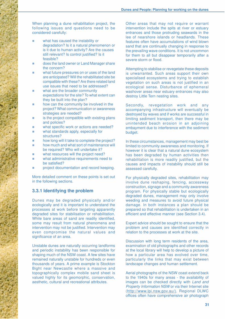
Dunes and People: Planning for working on the dunes
31
When planning a dune rehabilitation project, the
following issues and questions need to be
considered carefully:
n what has caused the instability or
degradation? Is it a natural phenomenon or
is it due to human activity? Are the causes
still relevant? Is control justified? Is itfeasible?
n does the land owner or Land Manager share
the concern?
n what future pressures on or uses of the land
are anticipated? Will the rehabilitated site be
compatible with these? Are there related land
use issues that need to be addressed?
n what are the broader community
expectations for the site? To what extent can
they be built into the plan?n how can the community be involved in the
project? What communication or awareness
strategies are needed?
n is the project compatible with existing plans
and policies?
n what specific work or actions are needed?
n what standards apply, especially for
structures?
n how long will it take to complete the project?
n how much and what sort of maintenance willbe required? Who will undertake it?
n what resources will the project need?
n what administrative requirements need to
be satisfied?
n project documentation and record keeping.
More detailed comment on these points is set out
in the following sections.
3.3.1 Identifying the problem
Dunes may be degraded physically and/or
ecologically and it is important to understand the
processes at work before targeting apparently
degraded sites for stabilisation or rehabilitation.
While bare areas of sand are readily identified,
some may result from natural phenomena and
intervention may not be justified. Intervention may
even compromise the natural values andsignificance of an area.
Unstable dunes are naturally occurring landforms
and periodic instability has been responsible for
shaping much of the NSW coast. A few sites have
remained naturally unstable for hundreds or even
thousands of years. A prime example is Stockton
Bight near Newcastle where a massive and
topographically complex mobile sand sheet is
valued highly for its geomorphic, conservation,aesthetic, cultural and recreational attributes.
Other areas that may not require or warrant
intervention include the spits at river or estuary
entrances and those protruding seawards in the
lee of nearshore islands or headlands. These
features often have accumulations of wind blown
sand that are continually changing in response to
the prevailing wave conditions. It is not uncommon
for them to all but disappear temporarily after asevere storm or flood.
Attempting to stabilise or revegetate these deposits
is unwarranted. Such areas support their own
specialised ecosystems and trying to establish
vegetation on such areas is not justified in an
ecological sense. Disturbance of ephemeral
washover areas near estuary entrances may also
destroy Little Tern nesting sites.
Secondly, revegetation work and any
accompanying infrastructure will eventually be
destroyed by waves and if works are successful in
limiting sediment transport, then there may be
unintended beach erosion in an adjoining
embayment due to interference with the sediment
budget.
In these circumstances, management may best be
limited to community awareness and monitoring. Ifhowever it is clear that a natural dune ecosystem
has been degraded by human activities then
rehabilitation is more readily justified, but the
causes and impacts of instability should still be
assessed carefully.
For physically degraded sites, rehabilitation may
involve dune reshaping, fencing, accessway
construction, signage and a community awareness
program. For physically stable but ecologicallydegraded dunes, management may only involve
weeding and measures to avoid future physical
damage. In both instances a plan should be
prepared so that rehabilitation is undertaken in an
efficient and effective manner (see Section 3.4).
Expert advice should be sought to ensure that the
problem and causes are identified correctly in
relation to the processes at work at the site.
Discussion with long term residents of the area,
examination of old photographs and other records
at the local library will help to develop a picture of
how a particular area has evolved over time,
particularly the links that may exist between
landscape changes and human settlement.
Aerial photographs of the NSW coast extend back
to the 1940s for many areas - the availability ofimages can be checked directly with Land and
Property Information NSW or via their Internet site
(http://www.lpi.nsw.gov.au/). Regional DLWC
offices often have comprehensive air photograph
Coastal Dune Management
32
collections, as well as staff who may assist with
technical appraisals of relevant sites. Local councils
will often have many of these photographs too, and
are increasingly investigating and documenting
degraded sites as part of their annual State of
Environment reporting responsibilities.
3.3.2 Consult the Land Manager
Having identified a problem the next step is to
determine if anyone else shares that concern and
is planning to address it. There is no point investing
a lot of time and energy in developing a
rehabilitation project if it is already being tackled
by the council, another state government agency
or a community group.
The first point of enquiry should be the LandManager. This is most likely to be the local council
or the Department of Land and Water Conservation
(DLWC). In some cases it may be a Trust managing
a Crown Reserve, it may be the National Parks and
Wildlife Service or State Forests, or title may have
passed to a Local Aboriginal Land Council.
Alternatively the problem site may be undeveloped
land that is owned privately by a company or an
individual, in which case rehabilitation may be
problematic.
Local councils maintain current details of land
tenure and ownership in their property information
systems, while information about tenure and
management of Crown Land and of Aboriginal Title
claims is available from Crown Lands Access
Officers based in the Regional Offices of DLWC.
Consulting the appropriate land manager willestablish quickly if anything is already being done
or is planned in terms of rehabilitating the problem
site. In the event that an opportunity exists for a
third party to develop a rehabilitation project, the
Land Manager will be ideally placed to facilitate that
activity.
The Land Manager should be able to advise
whether initial support can be given, pending
submission of more specific project plans. He/sheshould be able to identify the range of activities
that can be undertaken, the approvals that may be
required, and the potential sources of funding or
in-kind support that may be available within an
organisation.
In projects driven by community groups,
rehabilitation is invariably going to involve working
on land that is owned and/or managed by someone
else. Their rights and responsibilities must berespected and these are reviewed very clearly in
Volunteers Working on the Coast (DLWC 1997).
3.3.3 Community consultation andparticipation
Strong community interest and involvement can
generate a sense of stewardship that is invaluable
in successfully completing and maintaining a dune
rehabilitation project. To this end, rehabilitation
planning must address the needs and expectationsof all users, including local residents and visitors.
Both existing users of the site and potential
stakeholders need to be identified (see Section 3.2)
and their views determined. The earlier this occurs
the more likely the project will attract sustained
community support. Ideally, efforts will extend
beyond basic consultation to having users help
formulate and implement the project plan. Thesuccess of these efforts relies upon an effective
community consultation exercise.
It is especially important to have local residents on
side. They will tend to be more “possessive” of a
site, especially if they are neighbours - land owners
adjoining the targeted lands, and are therefore more
likely to become actively involved in “hands-on”
activities. They are also probably the ones who will
eventually have a more direct interest in ongoingmaintenance and in reporting and deterring
vandalism.
Visitors’ needs and expectations should also be
canvassed. Having travelled further, they are more
likely to spend whole days at the beach and/or even
longer periods during their holidays. Their
expectations in terms of access and facilities and
the recreational experiences that they are seeking
may also differ from those of local residents. Whilethe more remote users may be targeted indirectly
through regionally based awareness programs,
direct contact should be attempted at the time(s)
they are most likely to visit the area, such as
weekends or holiday periods.
Variations in usage patterns should also be
considered. Beach hauling for example may only
occur once a year for a short period when a target
fish species is present.
Identification of future uses within at least a five-
year time frame should also be attempted when
developing the objectives of the rehabilitation
project.
In short, any dune rehabilitation and management
strategy should include a carefully planned
procedure to achieve and maintain strong
awareness and support within the broadercommunity.
Dunes and People: Planning for working on the dunes
33
Techniques to achieve this include:
n the use of local media to publicise and
promote the proposed works
n letter box drops in the beach neighbourhood
containing informative advisory material,
including progress reports
n public meetings and talks to specificcommunity groups such as Service Clubs
n addressing local schools - this can reduce
vandalism and help establish a lifelong
appreciation of the coastal dune environment
and the efforts of volunteers
n the correct use of signs. As a general rule
signs should be polite, informative and
directional (Chapter 4.8). They should
conform with the land manager’s
requirements and they should appeal topeople’s better instincts.
n the use of temporary signs like sandwich
boards to explain the purpose of the project
when work is actually being carried out.
n ensuring that workers involved in the
program are sufficiently aware of
project objectives, methods and outcomes
so that they can handle casual public
enquiries.
Carson and Gelber (2001) describe the principles
of community consultation and present a useful
comparison of favoured consultation procedures.
The merits of being neighbourly are also reviewed
in Volunteers Working on the Coast (DLWC 1997).
Local community involvement has been an integral
part of dune management over the last decade.
Activities by Dune Care, Coastcare and Landcare
groups working in partnership with local councilswith assistance from state and federal governments
have contributed greatly to the improvement of the
coastal environment. Many rehabilitation projects
would simply not have occurred without this
community input.
3.3.4 Compatibility with other plansand policies
Local councils and state government agencies
undertake coastal planning at several different
levels. Any proposal to rehabilitate a parcel of
coastal land should not conflict with those plans
that have local relevance.
The NSW Coastal Policy (NSW Government 1997)
is the umbrella policy for coastal management in
NSW. In conjunction with the Environmental
Planning and Assessment Act 1979 (EP&A Act) itguides local government in the planning and
management of the coast and in works and
activities impacting on the coast.
The policy has nine goals including:
n protecting, rehabilitating and improving the
natural environment of the coastal zone.
n recognising and accommodating the natural
processes of the coastal zone.
n protecting and enhancing the aesthetic
qualities of the coastal zone.n protecting and conserving the cultural
heritage of the coastal zone.
n providing for ecologically sustainable
development and use of resources.
n providing for ecologically sustainable human
settlement in the coastal zone.
n providing for appropriate public access and
use.
n providing for information to enable effective
management of the coastal zone.n providing for integrated planning and
management of the coastal zone.
Copies of the Policy can be obtained from the NSW
Department of Urban Affairs and Planning.
The Policy can also be accessed at http://
www.coastalcouncil.nsw.gov.au. Given that this
policy is based on ESD principles it is unlikely that
properly formulated coastal dune rehabilitationprojects will conflict with it.
Land use planning in NSW is implemented primarily
through planning instruments such as Local
Environmental Plans (LEPs), Regional
Environmental Plans (REPs) and State
Environmental Planning Policies (SEPPs). These
instruments are prepared and implemented in
accordance with the NSW Environmental Planning
and Assessment Act 1979 (EP&A Act).
Each council has its own LEP that establishes land
use zonings for all land within the local government
area and the land uses that are permissible within
each zoning. REPs and SEPPs are state
government instruments and LEPs must be
consistent with them. The NSW Department of
Urban Affairs and Planning (DUAP) has prepared
a useful review of the plan making process in NSW(DUAP 2001).
Development Control Plans (DCPs) may provide
additional guidance about a council’s requirements.
Practically all coastal land on which dune
rehabilitation is likely to be undertaken is zoned for
Open Space or Environmental Protection. The
majority is Crown Land that is managed either
directly by the Department of Land and WaterConservation (DLWC), by the local council under
a Care and Control agreement, or by a Reserve
Trust.

Coastal Dune Management
34
Some coastal land is also owned and managed
directly by councils and is classified either as
“community” or “operational” land. The classification
that applies is crucial when considering
rehabilitation potential.
The Crown Lands Act 1989 and the Coastal Crown
Lands Policy 1990 provide that Plans ofManagement be prepared for all coastal Crown
Land based on assessment of the lands’ values.
Similarly the NSW Local Government Act 1993
requires that councils prepare Plans of
Management for “community land”. These plans
provide varying opportunities for rehabilitation;
some are site specific, many others are generic.
Dune rehabilitation projects need to be consistent
with these plans.
Local councils also zone coastal land belonging to
the National Parks and Wildlife Service (NPWS)
but land management remains the Service’s
responsibility. NPWS activities are undertaken in
accordance with a Plan of Management prepared
for each Park. Increasingly, the NPWS is
undertaking rehabilitation projects in partnership
with members of the local community.
Coastal processes and hazards are specificallyrecognised and accommodated through the NSW
Coastline Hazard Policy 1988. This provides for
the development of Coastline (Coastal)
Management Plans by councils. These plans are
developed following the procedure outlined in the
Coastline Management Manual (NSW Government
1990). The NSW Coastal Policy endorses the
preparation of these Coastal Management Plans
but encourages councils to extend their scope more
broadly.
The coastal management plan process is managed
by local councils and encourages community
involvement and ownership. The process includes
assessment of coastal processes and hazards,
consideration of all available management options
and selection of the best options having regard to
all social, economic and ecological issues.
While an initial task in preparing these coastal
management plans is undertaking a hazard
definition study, these are increasingly
comprehensive studies of specific sections of the
coast. They are often an invaluable source of
background reference material that can be used in
planning a dune rehabilitation project. Many plans
specifically identify dune areas that require
rehabilitation.
3.4 Preparing a Rehabilitation Plan
Once the bounds to the dune rehabilitation problem
have been broadly determined and initial
consultation with the land manager and the
community has identified the main opportunities
and constraints that are relevant, together with any
approvals that are needed, then it is possible tobegin more formal planning of the project.
Preparation of a specific project plan is
recommended for two reasons. Firstly it should
secure the benefits identified earlier (see 3.3);
secondly, such a document is invariably required
when seeking formal approvals and to support
applications for funding from other sources.
Buchanan (1989) also provides some valuable
advice on this planning process.
The plan should include the following elements:
n concise objectives or goals
n specific strategies or actions needed to
achieve those objectives and maintain the
outcomes
n some performance measures; things that
objectively demonstrate success
n regular review of the plan.
Many councils and other Land Managers now
require preparation and submission of project plans
before any works begin. Varying levels of
assistance are provided. The formats also vary
according to local requirements but all address a
common set of core items. An example from Coffs
Harbour is included at the end of this chapter
(Figures 3.4a,b).
3.4.1 Setting some goals
Having identified a problem area, it should be fairly
easy to develop a “vision” for what the area will
look like in say two, five or ten years time when the
rehabilitation work has been completed. This
should be developed with the broader community,
having considered likely future usage patterns.
The next step is to turn this vision into a number of
concise objectives. These need to be clearly stated
and realistic. In more complex projects a series of
staged objectives should be established, building
progressively upon each other. This approach is
especially valuable when work is being undertaken
by members of the community; the resultant sense
of achievement at each stage is invaluable in
maintaining or building motivation and commitment.
Dunes and People: Planning for working on the dunes
35
It is strongly recommended that a site map is
prepared to accompany the written plan, based on
a thorough understanding of the assessment. This
will assist greatly in setting priorities and project
objectives. As time progresses, revised versions
of the map are also useful for recording and
displaying progress.
While maps can be prepared effectively by
freehand drawing, they should always be drawn to
scale and have their orientation marked. Usually
the local council will have maps at suitable scales
that can be used as a basis for the project mapping.
Aerial photographs, especially the more recent
colour and large-scale versions can also help here
(see Section 3.3.1).
3.4.2 What specific works or actionsare needed?
This will be determined by the extent of site
degradation and the standard of rehabilitation
deemed necessary. More often than not it will be
constrained by the resources that are available.
At a low-usage site, the only work needed may be
weed control followed by monitoring of naturalregeneration. At sites where there has been severe
physical and ecological damage, and where high
intensity recreational use is expected to continue,
a large range of resource-intensive work may be
required over several years. This may involve dune
reconstruction and stabilisation, fencing, provision
of access, signage, weeding, revegetation,
community awareness and education, as well as
ongoing maintenance of all components.
Subsequent chapters of this Manual enlarge onthese specific practicalities.
All works require maintenance. This has often been
neglected in the past, with the result that the
benefits of project completion diminish, much of
the work invested in the project is wasted and
liability for injury to users increases. Maintenance
tasks need to be identified and given priorities, a
time line and adequate resources. Maintenance
needs to be considered at the beginning of aproject, rather than at the end.
Many elements of dune rehabilitation projects will
need to comply with various regulations developed
by councils and state agencies. These range from
obtaining formal approvals for works to safe
application of herbicides. There is also an even
greater array of standards and guidelines for many
products, works and structures. These have varying
legal status and failure to comply with them maybreach the “Duty of Care” and expose organisations
and/or individuals to future claims for liability.
Occupational health and safety (OH&S) aspects
need careful consideration. Issues are wide ranging
and include simple ones such as exposure to the
sun, risk of snake bite and use of protective clothing,
through to more complex ones such as use of
chainsaws and poisons. A risk assessment should
be undertaken for all projects, identifying the risks
and preparing strategies to address them.
Increasing numbers of councils require that an
OH&S accredited person be on site whenever work
is being carried out. Many councils also offer OH&S
training for volunteers.
Guidance on some of the current standards is
provided in the next chapter. Given that new and
often stricter standards and guidelines are
constantly being introduced, advice should alwaysbe sought to ensure proper compliance. The local
council or relevant state agencies such as NPWS
should be able to assist in this regard.
The skills required to carry out particular tasks also
need to be considered. If children are keen to help
as part of their school activities, or as members of
community youth groups such as Scouts, tasks that
are within their capabilities need to be identified. In
some instances engaging a contractor may be thebest way of providing specialist skills or satisfying
a duty of care. For example, a sensitive area such
as littoral rainforest may need the services of a
specialist bush regenerator. Different specialists
might be needed to carry out particularly hazardous
tasks such as herbicide application on steep slopes,
or to provide OH&S training for project workers.
3.4.3 Project duration
Realistic estimates of time needed to complete a
project and its various tasks need to be prepared.
Is the project a short-lived weeding program over
a few months, or is it a much more complex series
of tasks that need to be staged over several years?
The duration of projects will be affected by many
variables.
Some estimates will be straightforward. Forexample if two people can install 100m of plain wire
fencing in one day, it becomes fairly easy to
estimate how long that particular task will take when
the total length of fencing and the number of
available workers is known.
Some tasks will be restricted to particular seasons.
Aerial bitou spraying for example is restricted to
winter when native plants are dormant. Seed
gathering is restricted to summer, but will be laterin that season the further south collection takes
place. Year to year variations in climate will also

Coastal Dune Management
36
impact on this task. Planting of seed and seedlings
must obviously be matched to optimal growing
conditions. These too will vary along the coast. If
community labour is an important component,
participants’ availability and capabilities will need
to be considered. Monitoring and maintaining a
rehabilitated site may be needed for several years
after completion of site works.
In many projects, commencement of one task
depends on another one being completed first. For
example, grant funds may be needed before
fencing materials can be purchased, or new
plantings may depend on the successful
propogation of tubestock grown from seed gathered
the previous year.
All planning needs to provide for contingencies suchas funding delays, worker illness and unfavourable
weather conditions.
Preparing time lines can be a great help (Figure
3.3). They help to check progress, to co-ordinate
different activities and to keep an eye on future
tasks. They can be prepared at different scales.
For example, a broad one covering an entire project
lasting several years could be broken down into
more detailed ones covering shorter, fixedbudgetary periods, or revegetation tasks to be
carried out during a particular season of the year.
Figure 3.3 Schematic project time line
3.4.4 Project resources
Obvious resources are materials and the funds to
acquire them. Less obvious ones may include other
practical items like vehicle and tool maintenance,access to water, or funding of administrative items
such as incorporation, approvals, insurance,
photocopying, telephones and report production.
Consultants and contractors providing services
such as weeding or OH&S training may also need
to be budgeted for. These, together with product
costs and service charges such as plant hire need
to be assessed carefully so that accurate budgets
and funding proposals can be prepared. This willalso help to ensure that the public funds that often
support dune rehabilitation projects are used
effectively.
Councils undertaking coastal improvement works
are eligible for matching funding from the
Department of Land and Water Conservation under
the state Coastal Management Program. The
criteria governing the operation of other state and
federal programs should also be examined carefully
to see if funds can be obtained for a project or for a
component of it.
Community groups often take advantage of various
funding sources for their coastal projects. The size
of the project is likely to determine the source of
funding. For example, small projects may be funded
through a local government Bushcare Program or
by a Coastcare Seeding Grant. Local businesses
will often provide materials at attractive prices, or
sometimes as a donation. Many Service Clubs also
provide valuable support.
Larger community based projects are usually
funded by Coastcare under the Natural Heritage
Trust (NHT) program. State and federal government
programs are often reviewed and modified and new
ones introduced. It is recommended that contact
be made with the local DLWC Reserves Manager,
the regional Coastcare Facilitator and/or the local
Landcare Co-ordinator.
Contact details for Regional Coastcare Facilitators
and Coastcare funding can be found by accessinghttp://www.ea.gov.au/coasts/
Information about the Natural Heritage Trust is also
available on the World Wide Web at:
http://www.nht.gov.au/
Contact details for local Landcare Co-ordinators
can be obtained at: http://www.landcare.nsw.org/
Success in attracting funding or other support
depends on the quality of the grant application or
project proposal. Generally, a successful proposal
will:
n concisely address all the criteria specified
by the funding body
n show evidence of appropriate consultationn relate clearly to and be consistent with other
relevant policies, plans and regulations
n have clearly stated objectives that are
achievable within the specified time frame
n have a sound methodology
n have a proposed budget set out clearly
n demonstrate availability of and access to the
expertise required
n show that it will deliver good value for money
n be presented clearly and succinctly.
Time (Season, months, year or more)
Ta
sks t
o b
e p
erf
orm
ed
Site assessment
Monitoring
Site preparation
Planting
Weed control / maintenance
Seed collection & propagation
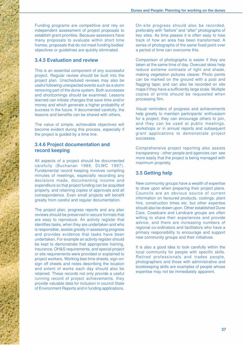
Dunes and People: Planning for working on the dunes
37
Funding programs are competitive and rely on
independent assessment of project proposals to
establish grant priorities. Because assessors have
many proposals to evaluate within short time
frames, proposals that do not meet funding bodies’
objectives or guidelines are quickly eliminated.
3.4.5 Evaluation and review
This is an essential component of any successful
project. Regular review should be built into the
project plan. Unscheduled reviews may also be
useful following unexpected events such as a storm
removing part of the dune system. Both successes
and shortcomings should be examined. Lessons
learned can initiate changes that save time and/or
money and which generate a higher probability of
success in the future. If documented carefully, thelessons and benefits can be shared with others.
The value of simple, achievable objectives will
become evident during this process, especially if
the project is guided by a time line.
3.4.6 Project documentation andrecord keeping
All aspects of a project should be documented
carefully (Buchanan 1989, DLWC 1997).
Fundamental record keeping involves compiling
minutes of meetings, especially recording any
decisions made, documenting income and
expenditure so that project funding can be acquitted
properly, and retaining copies of approvals and all
correspondence. Even small projects will benefit
greatly from careful and regular documentation.
The project plan, progress reports and any plan
reviews should be preserved in secure formats that
are easy to reproduce. An activity register that
identifies tasks, when they are undertaken and who
is responsible, assists greatly in assessing progress
and provides evidence that tasks have been
undertaken. For example an activity register should
be kept to demonstrate that appropriate training,
insurance, OH&S requirements, and special project
or site requirements were provided or explained toproject workers. Working bee time sheets, sign on/
sign off sheets and notes describing the location
and extent of works each day should also be
retained. These records not only provide a useful
running record of project achievements, they
provide valuable data for inclusion in council State
of Environment Reports and in funding applications.
On-site progress should also be recorded,
preferably with “before” and “after” photographs of
key sites. As time passes it is often easy to lose
track of how an area has been transformed. A
series of photographs of the same fixed point over
a period of time can overcome this.
Comparison of photographs is easier if they aretaken at the same time of day. Overcast skies help
reduce extreme contrasts of light and shade,
making vegetation pictures clearer. Photo points
can be marked on the ground with a post and
flagging tape; and can also be recorded on site
maps if they have a sufficiently large scale. Multiple
copies of prints should be requested when
processing film.
Visual reminders of progress and achievementshelp greatly to maintain participants’ enthusiasm
for a project; they can encourage others to join,
and they can be used at public meetings,
workshops or in annual reports and subsequent
grant applications to demonstrate project
successes.
Comprehensive project reporting also assists
transparency - other people and agencies can see
more easily that the project is being managed withmaximum propriety.
3.5 Getting help
New community groups have a wealth of expertise
to draw upon when preparing their project plans.
Councils are an obvious source of current
information on favoured products, costings, plant
hire, construction times etc. but other expertiseshould also be drawn upon. Other established Dune
Care, Coastcare and Landcare groups are often
willing to share their experiences and provide
advice, and there are increasing numbers of
regional co-ordinators and facilitators who have a
primary responsibility to encourage and support
new community groups and their initiatives.
It is also a good idea to look carefully within the
local community for people with specific skills.Retired professionals and trades people,
photographers and those with administrative and
bookkeeping skills are examples of people whose
expertise may not be immediately apparent.

Coastal Dune Management
38
Figure 3.4a Project Plan information sought by a Land Manager
Coffs Harbour City CouncilParks and Recreation Branch
COMMUNITY ‘CARE’ GROUP PROJECT PLANS
INFORMATION REQUIRED:
1. Group and Project Details:
Project Name: .............................................................................................................................................................................
Location: .............................................................................................................................................................................
Group: .............................................................................................................................................................................
Current Group Contact Details: ....................................................................................................................................................
.......................................................................................................................................................................................................
2. Overall Group Plan:
Objectives: .............................................................................................................................................................................
......................................................................................................................................................................................................
......................................................................................................................................................................................................
Specific area of land covered (show on site plan): ............................................................................................................
......................................................................................................................................................................................................
......................................................................................................................................................................................................
Short to Long term works (show on site plan with lists and descriptions where required):
Bush Regeneration:
� Areas for regeneration, revegetation/planting, weed control
� Vegetation types, native and weed species present
Access and facilities:
� Fencing
� Paths and beach access
� Drainage
� Signs
� Seats
� Other
Priorities for the above (use 1st, 2nd and 3rd priority - no time frame required)
......................................................................................................................................................................................................
......................................................................................................................................................................................................
......................................................................................................................................................................................................
If you have an existing plan that sets out the necessary information, please let us know.

Dunes and People: Planning for working on the dunes
39
1. Priorities and Funding 99/00:
What works would your group like to see achieved this financial year (July 99 - June 00) ?
.......................................................................................................................................................................................................
.......................................................................................................................................................................................................
Do you have funding for these works? Please specify.
.......................................................................................................................................................................................................
.......................................................................................................................................................................................................
What additional funding do you require? Do you intend applying for any specific funding programs?
.......................................................................................................................................................................................................
.......................................................................................................................................................................................................
Prorities and Funding 00/01
What works would your group like to see achieved next financial year (July 00 - June 01)?
........................................................................................................................................................................................................
.......................................................................................................................................................................................................
.......................................................................................................................................................................................................
Please specify whether you need to apply for funding for these works.
.......................................................................................................................................................................................................
.......................................................................................................................................................................................................
.......................................................................................................................................................................................................
Other Information:
This information would be helpful to complete our records:
� Brief outline of works achieved in 1998/99 financial year ................................................................................................
..........................................................................................................................................................................................
..........................................................................................................................................................................................
� Total volunteer hours contributed 1998/99 .............................................................................................................
� What year was your group formed? .........................................................................................................................
� Have you had any studies or plans completed for your area (eg. flora & fauna studies, bush regeneration plans)?
..........................................................................................................................................................................................
..........................................................................................................................................................................................
� Are there any specific issues you would like to let us know about your group area or land care in general?
..........................................................................................................................................................................................
..........................................................................................................................................................................................
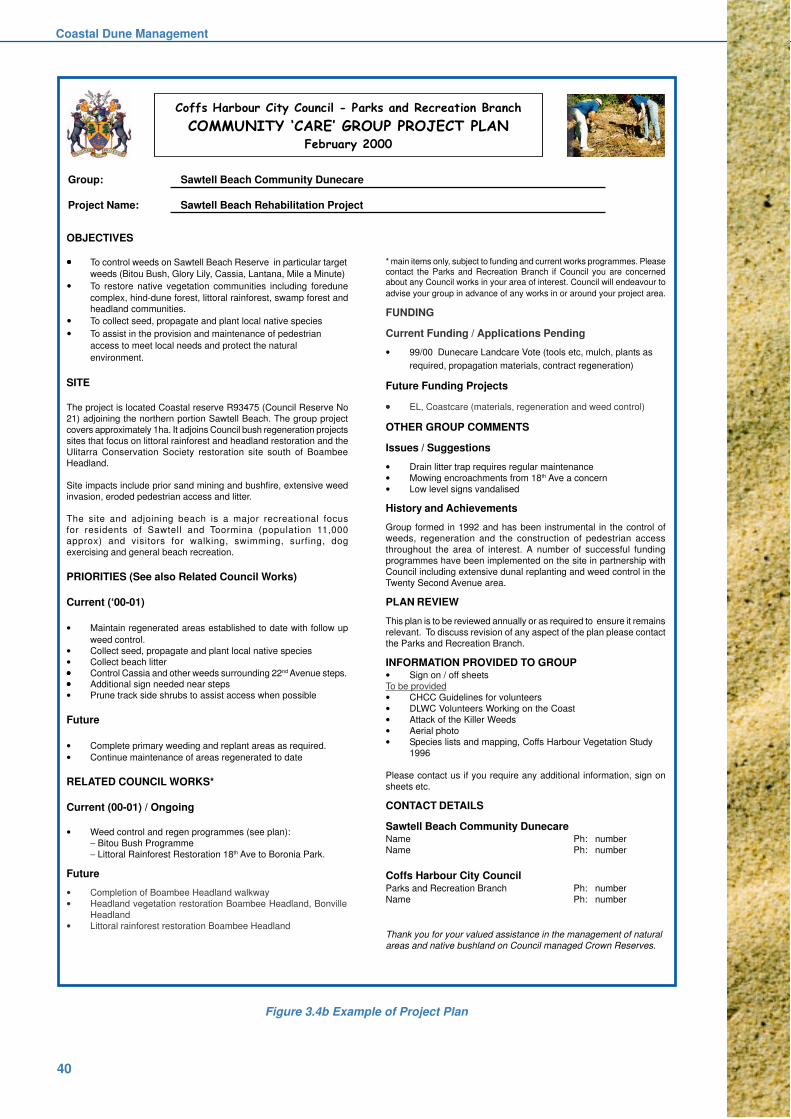
Coastal Dune Management
40
Coffs Harbour City Council - Parks and Recreation Branch
COMMUNITY ‘CARE’ GROUP PROJECT PLANFebruary 2000
Figure 3.4b Example of Project Plan
OBJECTIVES
����� To control weeds on Sawtell Beach Reserve in particular target
weeds (Bitou Bush, Glory Lily, Cassia, Lantana, Mile a Minute)
� To restore native vegetation communities including foredune
complex, hind-dune forest, littoral rainforest, swamp forest and
headland communities.
� To collect seed, propagate and plant local native species
� To assist in the provision and maintenance of pedestrian
access to meet local needs and protect the natural
environment.
SITE
The project is located Coastal reserve R93475 (Council Reserve No
21) adjoining the northern portion Sawtell Beach. The group project
covers approximately 1ha. It adjoins Council bush regeneration projects
sites that focus on littoral rainforest and headland restoration and the
Ulitarra Conservation Society restoration site south of Boambee
Headland.
Site impacts include prior sand mining and bushfire, extensive weed
invasion, eroded pedestrian access and litter.
The site and adjoining beach is a major recreational focus
for residents of Sawtell and Toormina (population 11,000
approx) and visitors for walking, swimming, surfing, dog
exercising and general beach recreation.
PRIORITIES (See also Related Council Works)
Current (‘00-01)
• Maintain regenerated areas established to date with follow up
weed control.
• Collect seed, propagate and plant local native species
• Collect beach litter
••••• Control Cassia and other weeds surrounding 22nd Avenue steps.••••• Additional sign needed near steps
• Prune track side shrubs to assist access when possible
Future
• Complete primary weeding and replant areas as required.
• Continue maintenance of areas regenerated to date
RELATED COUNCIL WORKS*
Current (00-01) / Ongoing
• Weed control and regen programmes (see plan):
− Bitou Bush Programme
− Littoral Rainforest Restoration 18th Ave to Boronia Park.
Future
• Completion of Boambee Headland walkway
• Headland vegetation restoration Boambee Headland, Bonville
Headland
• Littoral rainforest restoration Boambee Headland
* main items only, subject to funding and current works programmes. Please
contact the Parks and Recreation Branch if Council you are concerned
about any Council works in your area of interest. Council will endeavour to
advise your group in advance of any works in or around your project area.
FUNDING
Current Funding / Applications Pending
• 99/00 Dunecare Landcare Vote (tools etc, mulch, plants as
required, propagation materials, contract regeneration)
Future Funding Projects
••••• EL, Coastcare (materials, regeneration and weed control)
OTHER GROUP COMMENTS
Issues / Suggestions
• Drain litter trap requires regular maintenance
• Mowing encroachments from 18th Ave a concern
• Low level signs vandalised
History and Achievements
Group formed in 1992 and has been instrumental in the control of
weeds, regeneration and the construction of pedestrian access
throughout the area of interest. A number of successful funding
programmes have been implemented on the site in partnership with
Council including extensive dunal replanting and weed control in the
Twenty Second Avenue area.
PLAN REVIEW
This plan is to be reviewed annually or as required to ensure it remains
relevant. To discuss revision of any aspect of the plan please contact
the Parks and Recreation Branch.
INFORMATION PROVIDED TO GROUP• Sign on / off sheets
To be provided
• CHCC Guidelines for volunteers
• DLWC Volunteers Working on the Coast
• Attack of the Killer Weeds
• Aerial photo
• Species lists and mapping, Coffs Harbour Vegetation Study
1996
Please contact us if you require any additional information, sign on
sheets etc.
CONTACT DETAILS
Sawtell Beach Community DunecareName Ph: number
Name Ph: number
Coffs Harbour City CouncilParks and Recreation Branch Ph: number
Name Ph: number
Thank you for your valued assistance in the management of natural
areas and native bushland on Council managed Crown Reserves.
Group: Sawtell Beach Community Dunecare
Project Name: Sawtell Beach Rehabilitation Project
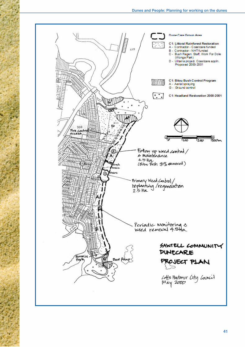
Dunes and People: Planning for working on the dunes
41
Coastal Dune Management
42
3.6 References and further reading:
Buchanan R.A. 1989, Bush Regeneration: Recovering
Australian Landscapes, TAFE Student Learning
Publications, Sydney.
Carson L. and Gelber K. 2001, Ideas for Community
Consultation, NSW Department of Urban Affairs and
Planning, Sydney.
DLWC 1997, Volunteers Working on the Coast, NSW
Department of Land and Water Conservation, Sydney.
DUAP 2001, PlanFirst, Review of plan making in NSW
White Paper, NSW Department of Urban Affairs and
Planning, Sydney.
Greening Australia 1995, Local Greening Plans: A
Guide for Vegetation and Biodiversity Management,
Greening Australia, Canberra.
Malmberg C. and Devine P. 1996, Succeeding with
Plans of Management, A guide to the LocalGovernment Act and Crown Lands Act, NSW
Department of Land and Water Conservation and
Manides Roberts Consultants, Sydney.
NSW Government 1990, Coastline Management
Manual, Sydney.
NSW Government 1997, NSW Coastal Policy 1997: A
Sustainable Future for the New South Wales Coast,
Department of Urban Affairs and Planning, Sydney.
Surf Life Saving Australia Limited 1998, EcoSurf Code
of Practice, SLSA and Coastcare.

Dune Reconstruction and Protection
43
4. DUNERECONSTRUCTION ANDPROTECTION
4.1 Introduction
Dune rehabilitation projects vary greatly in scale
and complexity depending primarily on the extent
to which the existing dune system has been
degraded.
At all sites a primary goal is to try to establish a
landscape that resembles as closely as practible,
the dunes that were present before the degradation
began (see Section 3.3.1).
At some sites, erosion or other damage may havebeen so severe that the first task is to reshape thesand mass into a landform that might reasonablybe expected to have developed naturally. At othersites the dunes themselves may not have sufferedany erosion, and degradation may be limited toinvasion by weeds, in which case rehabilitation mayonly involve some access and weed control.Variations in visitation levels affect the type andlevel of control structures that may also be needed,such as fencing, accessways and signage.
While all these aspects are addressed here, it isemphasised that they do not all apply to everyproject site.
Caution: In planning any dune works, from largescale reconstruction through to minor weed controlor erection of signs, the possibility of personal injuryarising directly or indirectly from such work, or fromdeficiencies in ongoing maintenance in the futuremust always be considered.
This and subsequent sections of the Manualprovide general guidelines and advice for effectivedune management. It is stressed that localconditions or changing technological or regulatoryenvironments may require departures from theseguidelines.
4.2 Reforming (rebuilding andreshaping) dunes
Any revegetation program proposed for degradedcoastal dunes requires a landform that encouragesthe establishment and survival of grasses or shrubsand trees. In badly degraded areas, preparing asuitable landform may involve rebuilding orreshaping the dunes. This may involve filling ofsmall blowouts, or on a larger scale, thereconstruction of hundreds of metres of dune. Theappropriate level of environmental impactassessment must precede such work.
Natural dunes vary in slope, size and shape
depending on the combination of factors that have
controlled their formation. This topographic
variability also contributes to subtle but valuable
variations in microclimate and habitat. Therefore,
reconstructed dunes should also vary in slope, size
and shape just as natural dunes do. However
unnatural protruding hummocks or steep-sidedundulations that may interrupt or concentrate wind
flow should be avoided. These large irregularities
can also make vegetation establishment difficult or
even impossible, and frequently lead to the
formation of even larger blowouts.
The dimensions of the reconstructed dunes will
depend on those of the remnant dune, the location
of the dune and the type and availability of sand to
be used for reconstruction. Dimensions may beconstrained by the location of structures such as
buildings, car parks or roads. This problem is
common in urban areas where it is often only
possible to reconstruct the seaward face of the
foredune. In areas where these limitations are
absent, it may be possible to reconstruct an entire
dune system.
Several methods can be used to reshape dune
contours depending on the scale of degradation.They include the use of earthmoving equipment or
sand trapping techniques such as dune-forming
fences, the spreading of brush matting and
revegetation. The following guidelines address the
factors to be considered when reforming dunes.
Note that coastal dunes often contain sites and
materials of Aboriginal significance (see Section
3.2.1). These cannot be disturbed or destroyed
without prior approval of the NPWS. The localAboriginal community should also be consulted. It
may be necessary for an Aboriginal representative
to be on-site during dune reshaping.
Consultation with local Aboriginal communities
and the NPWS should be undertaken early in
the planning process to determine the presence
of any cultural or archaeological sites and the
extent of any restrictions upon their disturbance(also see Section 3.2.1).
4.2.1 Material
The sand used in dune reconstruction should match
the grain size of the sand in the adjacent remaining
dune. Finer material will be more mobile and the
new dune may be eroded more rapidly than the
existing dunes. If the new grain size is larger,
revegetation may be difficult because the increasedporosity leads to increased drainage and problems
of low moisture and nutrient retention. Foreign
material such as rubble, rubbish and earth fill should

Coastal Dune Management
44
not be used as it is unlikely to provide the right
conditions for establishment of a coastal dune
ecosystem, and often creates more problems with
introduced weeds.
Sand dredged from bays, river mouths and
estuaries may be suitable sediment but will require
careful examination of its suitability. The PortBotany Development Project (Sydney) and the
Kooragang Island Project (Newcastle) are two
examples of large-scale development involving the
use of dredged material for land reclamation. Sand
dunes may also be artificially constructed from
dredged material but will need to be stabilised with
vegetation.
Experience has shown that dredged material may:
n have a low pH
n have acid sulfate potential
n harden when dried
n not retain adequate moisture for plant growth
n be chemically infertile
It has been recommended that any such material
be carefully analysed for heavy metal
concentrations, nutrient levels, moisture retention,
salinity, pH and acid sulfate potential prior to use.Analysis will provide invaluable assistance when
planning and implementing revegetation programs.
Problem areas can be isolated and solutions found
before the costly step of revegetation is
commenced.
The salinity level of recently dredged sand does
not pose many problems because salt is leached
out of the top few centimetres of sand after about
50mm of rain has fallen (or the equivalent inirrigation), provided that infiltration and drainage is
normal.
4.2.2 Position
The position of a reconstructed dune is governed
by that of existing dunes in the area and by the
location of any structures it may be designed to
protect. An adequate beach berm width must bemaintained to permit normal coastal processes,
especially at elevated high water levels during
storms.
A reconstructed dune should be integrated with any
remnant dunes and should run approximately
parallel with the beach berm. Allowance should be
made for normal variations in berm width due to
increasing wave exposure and occurrence of rips.
Major inflections in the seaward face of the duneshould be avoided as these will cause the wind to
eddy and remove sand, and they facilitate wave
incursions. Too many bends in the dune also adds
to fencing costs.
4.2.3 Slope and shape
Natural dune gradients range from zero to 1 in 1.5
(1 Vertical :1.5 Horizontal) and vary considerably
at any site. The primary objective in reforming
degraded dunes should be to re-establish the
diversity of landform that existed before initial
disturbance. This should also assist re-establishment of an appropriate dune ecosystem.
While gentle gradients are easier to work upon and
maintain, and may assist moisture retention and
subsequent revegetation, reconstruction of steeper
versions should not be avoided altogether.
Examples of steeper slopes include the naturally
revegetated seaward faces of many foredunes that
were steeply scarped during the storms of the mid-
1970s, and some landward slopes sheltering olderlittoral rainforest communities. Where space is
limited, steeper slopes may be unavoidable.
Reconstructed dunes should have aerodynamically
stable shapes. Seaward faces of foredunes should
be flat to slightly convex in shape. This helps to
deflect onshore winds in an upward direction, which
then provides a sheltered area on the lee side of
the dunes. This in turn helps the establishment of
vegetation.
Where space permits, an incipient foredune may
also be incorporated on the seaward side of the
reformed dune. This provides additional protection
for the foredune and its emerging vegetation.
4.2.4 Height and width
The height and width of a reconstructed dunedepends on a number of factors including:
n the height and width of existing dune
remnants
n the availability of sand
n available space
n the degree of landward protection required.
It may be desirable to reconstruct the dune to a
height that will prevent wave overtopping duringstorms. Expert on-site advice on these aspects of
dune reconstruction should be sought from the
appropriate coastal section of the Department of
Land and Water Conservation during the project-
planning phase.

Dune Reconstruction and Protection
45
4.3 Dune-forming fences
The principal function of a dune-forming fence is
to reduce the wind velocity, thereby causing drift
sand to be deposited in the vicinity of the fence
(Figure 4.1). This technique can be used for small
blowouts, for larger scale dune formation and at
sites where it is not feasible to import new material.However, these fences are generally used on
smaller isolated blowouts that are still surrounded
by functional dunes and vegetation. Dune-forming
fences are particularly useful in environmentally or
culturally sensitive areas where it is undesirable to
use earthmoving equipment or where access is
difficult.
The major disadvantages of dune-forming fences
are their susceptibility to vandalism and theuncertainty of how long it will take for the desired
dune profiles to become established. Dune-forming
fences are useful if the rehabilitation program is of
long duration, although their re-exposure some
years later may create new hazards or beach
debris.
Dune-forming fences can be installed during the
non-planting season to allow for a gradual build-
up of sand (although in some cases the fences may
fill in a matter of hours). Planting can commence
when the fences have filled with sand. This allows
greater long-term utilisation of labour and provides
work during the non-planting season.
Dune-forming fences are most commonly made of
a porous material such as a woven synthetic cloth
with approximately 40% porosity. This material is
attached to plain wire strained between treated pine
posts (Figure 4.2a).
Figure 4.1 Dune-forming fences, Kurnell
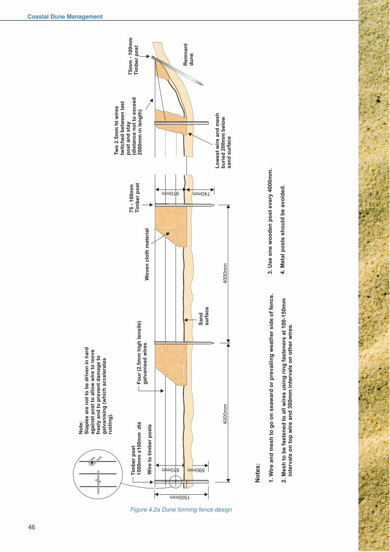
Coastal Dune Management
46
Figure 4.2a Dune forming fence design

Dune Reconstruction and Protection
47
Various other designs have been used depending
on local circumstances and availability of materials.
Almost any very porous material that can reduce
wind speed and trap sand can be used. Originally,
natural materials such as driftwood or brush were
used to great effect. Wooden slats laced together
and hessian have also been used. Overall however,
modern synthetic cloth materials afford flexibilityof design, ease of construction, durability and
economy.
The woven cloth needs to be secured at the base
by digging it at least 200mm into the sand and
attaching it to the top, intermediate and bottom
wires. The ends of the fence also need to be firmly
embedded and anchored within a stable object
such as the side of the blowout to prevent sand
from moving under or around the fence.
Dune-forming fences need to be positioned at right
angles to the prevailing wind to be most effective.
They should be straight where possible. Side wings
or zigzag patterns are not recommended. The fence
and the material are designed to be buried by
drifting sand. Do not attempt recovery of the fence.
In planning fence installation, sand can be expected
to accumulate in a zone whose width is 5-10 timesthe fence height. The actual width will vary
according to wind and sand characteristics. To build
a very wide dune, a series of parallel fences can
be constructed at 2-5 metre spacings. To build up
dune height, additional fences may need to be
constructed above the original fences when they
have filled with sand (Figure 4.2b). This should be
repeated until the height of the sand trapped by
the dune fences approximates the height of the
surrounding dunes.
A 2-person team can erect approximately 50 metres
of dune forming fence per day.
4.4 Dune rebuilding with earthmovingequipment
In some circumstances earthmoving equipment canbe used to rebuild dunes. This is an expensive
option but it can have the advantage of
reconstructing large sections of eroded dunes to
desirable size, shape and location within a short
time frame. It can sometimes be undertaken
effectively on an “opportunity basis”, in conjunction
with another project for example. This sort of work
is usually part of a large-scale project that is
designed and managed by full time professional
staff.
Several aspects need to be considered but special
care should be taken not to disturb significant areas
of existing vegetation. This option will invariably
require approval and environmental impact
assessment.
4.4.1 Survey
Whenever possible, survey the dune to bereconstructed at 1:500 scale. This will show where
available sand is situated, where blowouts are and
where fill is required. The survey information,
together with on-site inspections, allows accurate
planning of reconstruction methods, sand
movement, the type of earthmoving machinery
required and estimation of costs. A second survey
after construction will confirm the amount of sand
moved and also forms a base upon which future
accretion or erosion can be measured.
Figure 4.2b Sequence for progressive installation of dune-forming fences.
Coastal Dune Management
48
4.4.2 Sand Sources
Ideally, sand that has drifted inland from the eroded
foredune should be used in the reconstruction
process. This brings the sand back into the natural
coastal system. Dune nourishment from off-site
sources can also be used successfully, provided
particle size and salt content is assessed (seeSection 4.2.1). Sand obtained from the beach berm
and below high water mark should be considered
only as a last resort where drift sand is unavailable.
As this may have adverse effects elsewhere within
the beach system an environmental impact
assessment and permission from the DLWC will
be required. Approvals will also be required from
other stakeholders such as NSW Fisheries.
4.4.3 Type and use of equipment
Earthmoving equipment that can be used in dune
reconstruction includes:
n Bulldozer - Used where sand is readily
available, extensive reshaping is required
and pushing distance is short.
n Front-end loader - Used for carrying smaller
quantities of sand moderate distances. Theyare valuable for accurately placing sand
where required with minimal environmental
disturbance and for transplanting primary
vegetation.
n Scraper - Used for carrying large quantities
of sand long distances. Scrapers require
open space with low slopes and also need a
bulldozer to push fill.
n Excavator - Used for pulling down eroded
dune batters.
Before choosing the size and type of equipment to
be used in dune reconstruction, also consider hire
rates and the experience and efficiency of the
operator. In many cases smaller equipment with
an experienced operator will result in a better, less
expensive job than larger equipment.
When moving sand with a bulldozer, short pushes
are best. Where possible, push sand from theeroded dune crest downhill to form the seaward
slope. Push drift sand from behind the dune uphill
to form the dune crest and landward slope. Move
sand in trenches by slot dozing. This stops sand
from being lost around the ends of the dozer blade.
Once the majority of the sand has been moved
through the trenches, it becomes a simple task to
push out the windrows and smooth off the slopes.
4.4.4 Timing of reconstruction
Dune reconstruction works using earthmoving
equipment should be timed carefully so that
completion of the various stages of reconstruction
coincides with the appropriate season for planting
primary dune stabilising vegetation. If the works are
completed too far in advance of planting, thelikelihood of dune erosion by wind is extremely high.
This will necessitate further dune reconstruction
leading to cost overruns on the project.
However, if planting is undertaken too soon after
the dune has been constructed, the vegetation may
fail to establish because there was insufficient
moisture in the reworked sand, the sand was not
suitably consolidated to aid plant growth, or salt
had not yet been leached from the plant root zone.
The correct timing of dune reconstruction work
depends greatly on climatic conditions,
planting season, availability of planting
materials and the experience of the program
managers and supervisors. Between
reconstruction and revegetation the use of a
temporary stabiliser may be necessary (see
Section 4.5).
4.4.5 Dune reshaping after storms
The erosion scarps that are produced along the
seaward face of foredunes during severe or
prolonged storms are inherently unstable. Even
when bound together strongly by plants they will
eventually slump to a more stable surface. Until
this occurs, they may present a hazard to beach
users, especially near more populated centreswhere children delight in jumping from or tunnelling
into them. In these circumstances, intervention to
reduce the risk may be warranted, for example by
erecting warning signs and temporary exclusion
fencing.
If the risk is deemed to be particularly high, slumping
may be induced by judicious use of machinery. This
activity should be kept to the minimum necessary
to create a stable sand surface. Damage tovegetation should also be minimised as the
exposed plant roots and spinifex runners that often
end up being draped down the face of the scarp
play a crucial role in trapping wind blown sand and
repairing the damaged foredune.
Erosion may expose sites of Aboriginal significance
that have not been previously identified. Evidence
of such sites (middens, artefacts etc) should be
reported to the NPWS and the Local AboriginalLand Council.

Dune Reconstruction and Protection
49
4.5 Temporary dune stabilisers
In many situations an immediate stabilising cover
is required on bare sand to prevent drift. Examples
may vary from small blowouts starting where dunal
vegetation has been damaged, to larger areas of
bare sand resulting from the reforming or repairing
of a dunal system by earthmoving machinery. Inthe latter case, the capacity of machinery to reform
a dune can often far outstrip the rate of planting of
suitable primary stabilising vegetation.
Temporary stabilisers can be used to establish a
cover in an emergency situation or to provide a
surface cover until more permanent vegetation
becomes established. They protect the sand
surface and can encourage sand trapping.
In broad terms, there are four main types of
temporary stabilisers:
n brushes and mulches
n liquid sprays
n cover crops
n geo-textiles
These four categories, described below, are not
mutually exclusive; a combination of methods maybe used depending on site conditions and the level
of erosion.
Note: Marram grass has often been used in the
past as a temporary stabiliser. Contemporary use
of this plant is discussed in Section 6.8.1.
4.5.1 Brushes and mulches
As brushes and mulches are harvested from donorareas, the first step in any program using thesematerials must be to obtain the approval of thelandowner or land management authoritycontrolling the donor land before harvestingcommences.
Brushes or mulches act as a surface wind barrier.They prevent loss of surface sand from theseedbed, retain moisture and provide shelter fordeveloping seedlings, and enhance sand accretion.Accreting sand stimulates the growth of primarycolonising grasses such as spinifex. This is one ofthe advantages of this type of material over liquidstabilisers that are generally only used inassociation with other types of wind barriers.
A range of materials is available for use as surfacewind barriers. Selection of a particular typegenerally depends on its availability, thepropagating material being used and the climaticconditions anticipated. Materials generally need tobe heavy enough not to blow away. This makescoarse fibrous materials the most favoured. These
include hand-laid brush matting and chipped plant
materials. Meadow hay with bitumen tacking is used
in some situations but extreme care must be
exercised to ensure that wind does not get
underneath and lift it in sheets. For this reason it is
not recommended for exposed positions.
Brush matting using branches cut from coastalshrubs is a time-honoured technique and is most
successful, particularly in foredune situations with
sown spinifex (Figure 4.3). Any area can be treated
and the technique is not restricted to any particular
zone of the dune system. In practice, the areas
treated by this method tend to be small. In more
populous areas, it can be hard to find donor areas
for brush harvesting due to urban encroachment,
while in other areas environmental sensitivity may
preclude it.
Figure 4.3 Brush matting is essential at exposed sites
to protect bare sand until new plants are established.
The technique is straightforward. Small branchesof coastal shrub species are gathered from wellvegetated donor areas. Coastal tea tree(Leptospermum laevigatum) is particularly suitable.Care is needed when harvesting to ensure that noshrub is denuded and harvesting is limited to oneto four limbs per shrub taken from the leeward side.Smaller branches should be broken off larger limbsto make the brush cover a larger area. Brush lengthshould be at least 600mm, but less than 1000mm.The butt end is pushed 150-300mm into the sand

Coastal Dune Management
50
at a horizontal angle of 10-15 degrees. The butt
end should face the prevailing wind direction. When
laid the brush should cover at least 60-80% of the
sand surface. If brush availability is limited, it can
be laid in rows 2-3 metres apart.
As the wind passes the brush and leaf tips,
velocities are reduced and the sand surfaceremains intact. Wind blown drift sand drops through
and is trapped beneath the brush. The amount of
sand that can be accreted by brush is significant
and the degree of protection it affords an otherwise
bare sand surface is excellent.
As most coastal shrub species are very woody,
brush breakdown is slow. Depending on the time
of harvesting, the brush may also present an
excellent seed source to introduce secondary andtertiary species in hind dune areas, provided they
occur natually in the area. Care must be taken to
avoid introducing seed from plants that are not
locally endemic. For example, Tea Tree seed
should not be introduced north of Nambucca Heads
(see Section 6.8.3).
Chipped plant material has been used
successfully where materials were readily
accessible. This can occur when rehabilitationcoincides with clearing for power lines, subdivisions
or other developments. The mineral sands industry
has often used chipped heath to protect sand dunes
after mining. The technique has also been used
successfully in the rehabilitation of quarries within
coastal heath areas. Unwanted vegetation such as
bitou and lantana can also be used to protect small
surface areas, provided it is not in seed.
Dead seagrass has proved successful on theCentral Coast. Normally seagrass that is washed
naturally from an estuary should be left intact as
part of the estuarine ecosystem. In this instance
however, it was legally removed from a coastal
lagoon as part of an approved estuary rehabilitation
project and used to mulch seedlings that had been
planted on the landward side of a newly graded
foredune.
4.5.2 Liquid sprays
Liquid sprays such as emulsified bitumen or
dispersed organic polymers provide temporary
stabilisation by aggregating or cementing sand
grains so that they cannot be moved by the wind.
Unlike brushes and mulches, these products do
not enhance sand accretion; mobile sand simply
passes over the surface and continues untilintercepted by other obstacles. Recommended
sprays do not interfere with the germination or with
the growth of seedlings, transplanted culms or
runners. Most allow reasonable air and water
exchange between the atmosphere and stabilised
sand.
The sprays are diluted in accordance with
manufacturers’ recommendations and are applied
using a bitumen pump. Application rates are critical
and coloured dyes are available to assist in thisregard. Once cured, the crusts can be damaged
by traffic so it is essential to fence treated areas.
Bitumen emulsion of the slow-breaking anionic
type has also been used extensively for sand
stabilisation, usually in conjunction with other
techniques. It is relatively stable and easy to handle
but 2500 litres is needed for each hectare. It is
diluted 4:1 with fresh water and combined with
sufficient emulsifier to retard breakdown andprovide about 50mm penetration. The treatment is
visually obvious and has the advantage of deterring
pedestrian traffic.
Conversely, the black, oily appearance of treated
areas can be a disadvantage if it generates adverse
public reaction, particularly on popular beaches
valued for their aesthetic amenity. More importantly,
the darkness of bitumen treated sand considerably
increases surface temperatures, which can causeroot damage and seedling mortality in hot weather.
However, bitumen can be a valuable material for
treatment of remote sites. Once applied the mixture
generally breaks down and disappears after 3-6
months.
Dispersed organic polymers: Various dispersed
organic polymer derivatives of petroleum are
suitable for use as temporary sand stabilisers. They
have several advantages over bitumen emulsion:
n they can be applied at much lower rates of
active ingredient (around 600 L/ha) therefore
requiring less cartage to site
n they are generally colourless to white, which
is more aesthetically acceptable and less
heat absorptive
n they have a distinct advantage in beach
situations of remaining dispersed insaline waters, which allows usage of
ocean or spear point supplies for mixing and
avoids the need to cart water to the site
Diluted organic polymers are applied with high
volume spraying equipment. Careful planning is
required before undertaking large jobs as large
volumes of water are required. Some products are
not always available and have a short shelf life.
Pumps and spray equipment must be cleanedduring and immediately after use, as the polymers
congeal rapidly.

Dune Reconstruction and Protection
51
4.5.3 Cover crops
Cover crops are generally intolerant of strong winds,
salt spray and significant sand burial. Thus, where
there is no migrating sand to accrete and it is a
matter of holding the sand surface in place while
secondary or tertiary species are established, then
a living plant mulch or cover crop is appropriate.By necessity, cover crops must germinate rapidly
and grow vigorously to provide a dense vegetative
cover capable of reducing wind velocity at the sand
surface.
Cover crops are not successful on foredunes, but
can be used in swales or other protected areas of
a dune system. They can also be used in artificial
dune environments, for example to stabilise large
tracts of land created by dredging sand from baysor estuaries.
Cover crops may be used to provide sand surface
stability, to protect emerging secondary species or
they may be used in their own right as a longer
term surface stabiliser. The length of time they
persist can be controlled by species selection and
by management of fertiliser inputs.
Crops are established from seed and are eithermachine or hand broadcast onto the sand surface
or drilled into the sand using an agricultural type
combine seeder. This offers the options of either
incorporating the seed of the secondary coastal
species with the seed of the cover crop and direct
sowing the lot, or planting nursery-raised tube stock
after germination and satisfactory growth of the
cover crop has stabilised the site.
Direct seeding of both cover crop and secondary/
tertiary native species is possible because of the
significant difference in time from sowing to
germination of agricultural type cover crops
compared to most native coastal species. However,
as all the factors that trigger the germination
mechanism of many native coastal species are not
fully understood, the final composition of a
vegetative cover established this way can vary
considerably.
If a specific vegetative composition is required, the
introduction of nursery-raised tube stock into an
established cover crop will give the desired result.
Selection of the correct species of cover crop is
essential. Broadly speaking there are two main
sowing seasons, warm and cold. Species may be
annual, ie. they germinate, grow, set seed and die
within a twelve month period; or they may beperennial, whereby the original plant continues to
live year-in year-out and may or may not set seed.
Given that a primary goal of contemporary dune
rehabilitation is the establishment and
enhancement of natural ecosystems comprising
locally indigenous plants, use of exotic cover crops
should only include hybrid species that do not set
viable seed.
Recommended cover crops include cereal rye
(Secale cereale), a cool season annual species andhybrid forage sorghum (Sorghum vulgare), a warm
season species.
4.5.4 Geo-textiles
Over the years many different types of geo-textiles
have become available. Products include coconut
fibre matting, open-weave nylon cloth and softwood
shavings contained in fine nylon mesh. Most are
relatively expensive and of limited use for thispurpose.
Some of these products inhibit the growth of
vegetation that is established by seed. All create
additional work in planting vegetative material such
as culms or runners, therefore resulting in additional
labour costs. A further disadvantage is that these
products can only cope with a very small amount
of sand accretion. Once the fabric is filled, sand
continues to travel over the buried fabric. They arealso subject to a high risk of vandalism.
While the initial purchase price of these products
is high, they should be considered when other
techniques are not appropriate. For example, they
may have application in difficult sites, or where
urgent, rapid repairs are necessary over small areas
in order to maintain beach use. They have also
been used successfully over large areas duringmine site rehabilitation. Material that breaks down
over time is preferred.

Coastal Dune Management
52
4.6 Protective fencing
Dune vegetation is particularly susceptible to
damage from pedestrian and vehicular traffic.
Fences are therefore used in dune areas to
preserve both revegetated and naturally vegetated
areas. The type of fence used depends on the:
n usage of the beach area
n location of the fence
n maintenance requirements
n public acceptability
n area to be protected
n material available
n finance available
The type of fence used should be suited to the area
where it is to be constructed and should befunctionally and visually acceptable to the users of
that area.
4.6.1 Fence position
Two major fence lines are generally used in dune
rehabilitation projects, one along the seaward
margin of the dune field, and another landward
fence that protects hind dune areas. Designatedaccessways (Section 4.7) provide controlled
opportunities for beach users to cross the dune field
and these are also usually fenced.
The seaward or frontal fence should be located
near the toe of the foredune, well above high water
wave runup levels (Figure 4.4a). It should also be
more or less parallel to the toe of the dune. Its
purpose is to protect sensitive vegetation but
positioning is problematic.
The further forward the fence is sited the more
vegetation it will protect but the likelihood of damage
or its removal by storm waves also increases.
Conversely, they may be partially or completely
buried by sand. Where there is a high risk of this
occurring, the fence used should be of simple
construction and easily maintained. At remote sites
a seaward fence may not be needed.
The location of fences in hind dunes will vary
according to constraints imposed by the landform,
existing vegetation and the presence of
developments such as car parks and caravan
parks. Where possible, these fences should be
constructed behind vegetation that will screen them
from view, thus maintaining a low visual impact
(Figure 4.4b). Alternatively, denser growing
vegetation can be planted adjacent to the fence to
provide both visual relief and an additional barrierto traffic. If this vegetative barrier develops
sufficiently the fence may not require eventual
replacement.
Figure 4.4 Siting of front fences is a challenge. The furtherseaward they are located the more vegetated sand they
can protect, but the risk of loss or damage during storms
increases (top). Well planned revegetation can merge
successfully with landward fences (below) for very
effective but less obtrusive protection.
In areas of low usage and dense dune vegetationwhere complete fencing of the dunes is not
required, fence “wings” can be constructed to direct
traffic to an accessway. These “wings” can run for
10-20m from the accessway before ending in the
surrounding vegetation.
4.6.2 Fence type and construction
This is dictated by local site characteristics. Different
types of fence have particular advantages and bycareful selection, time and money can be saved
on construction and maintenance costs. Potential
for personal injury is always an important
consideration, particularly on steep or awkward
sites.
The common types of dune protective fencing used
are:
n plain wire fencen Bayco® type fence
n wire mesh fence
n post and rail wooden fence

Dune Reconstruction and Protection
53
The key features of these fences are summarised
in Figure 4.5 while design and construction
recommendations are detailed in Figures 4.6a-d.
Additional comments are provided in the text.
Fence posts can be made from treated pine or from
hardwood grade timber. Pine is easier to work and
lighter to carry but hardwood grade timber can alsomake durable posts.
Plain wire fence: Plain wire fences are being used
more frequently in recent times because they are
relatively inexpensive and easy to construct and
maintain (Figure 4.6a). Plastic-coated wire is no
longer favoured as it rusts quickly when water
penetrates weakened coating and it is prone to
theft.
Plain wire fences are well suited to both low and
high usage areas, to areas where there is a rapid
accumulation of sand, and to areas where there is
a high probability of damage or destruction by
waves. Their simplicity encourages different and
innovative means of installation. All plain wire
fences need straining and various techniques are
available for doing so. Gripples for example, can
eliminate the need for more elaborate strainers.
Particular care is needed on undulating surfaces,
as straining will tend to lift posts out of depressions.
Star picket droppers can be hazardous and will
eventually rust; plastic ones need to be assessedcarefully for strength, UV resistance and the
likelihood of theft. The latter are expensive, become
brittle with time and are very sharp when broken.
A 2-person team can erect approximately 100
metres of plain wire fencing per day.
Figure 4.5 Comparison of dune fences.
FENCE TYPE RECOMMENDED LOCATION ADVANTAGES DISADVANTAGES
Plain Wire Seaward side and along toe of Cheap. Simple to erect. Lesser deterrent
access tracks on all beaches where Easy to maintain. capability. Subject to rust.
wave damage or sand burial is likely.
Bayco® Alternative to plain wire. Does not rust. Slightly more expensive
Simple to erect. easily vandalised & may
be more prone to theft.
Wire Mesh Seaward & landward sides and Height offers greater Expensive. High
along access tracks on medium to deterrent. Strong. maintenance. Poor
high use beaches where there is appearance. Subject to
negligible risk of damage. rust. Difficult to lift.
Post and Rail On medium use beaches Excellent appearance. Very high initial cost.
where there is minimal risk of wave Strong. Durable.
damage or burial. Around Surf Clubs Low maintenance.
& public amenities.
○ ○ ○ ○ ○ ○ ○ ○ ○ ○ ○ ○ ○ ○ ○ ○ ○ ○ ○ ○ ○ ○ ○ ○ ○ ○ ○ ○ ○ ○ ○ ○ ○ ○ ○ ○ ○ ○ ○ ○ ○ ○ ○ ○ ○ ○ ○ ○ ○ ○ ○ ○ ○ ○ ○ ○ ○ ○ ○
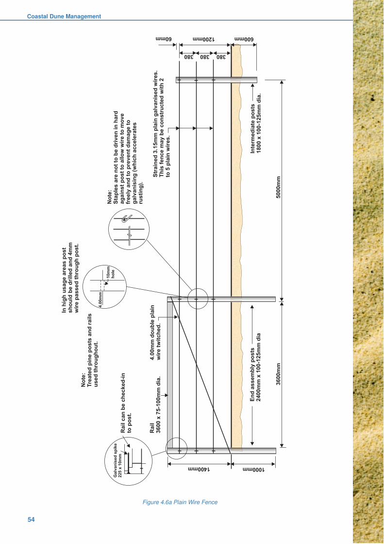
Coastal Dune Management
54
Figure 4.6a Plain Wire Fence

Dune Reconstruction and Protection
55
Figure 4.6b Bayco® fence

Coastal Dune Management
56
Figure 4.6c Wire Mesh fence

Dune Reconstruction and Protection
57
Figure 4.6d Post and rail wooden fence
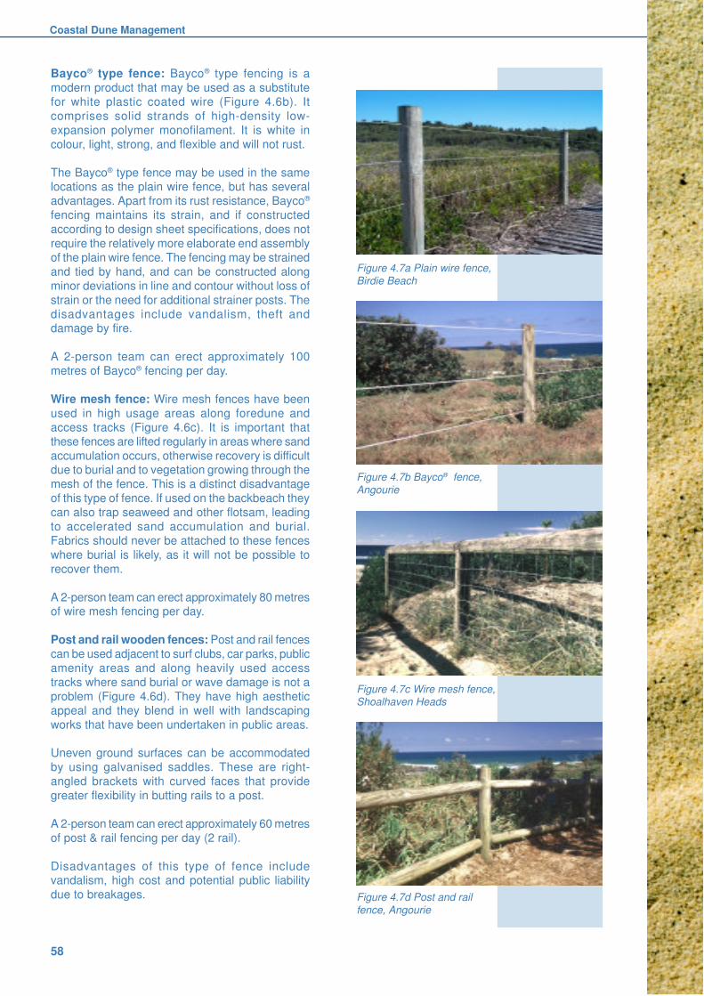
Coastal Dune Management
58
Bayco® type fence: Bayco® type fencing is a
modern product that may be used as a substitute
for white plastic coated wire (Figure 4.6b). It
comprises solid strands of high-density low-
expansion polymer monofilament. It is white in
colour, light, strong, and flexible and will not rust.
The Bayco® type fence may be used in the samelocations as the plain wire fence, but has several
advantages. Apart from its rust resistance, Bayco®
fencing maintains its strain, and if constructed
according to design sheet specifications, does not
require the relatively more elaborate end assembly
of the plain wire fence. The fencing may be strained
and tied by hand, and can be constructed along
minor deviations in line and contour without loss of
strain or the need for additional strainer posts. The
disadvantages include vandalism, theft anddamage by fire.
A 2-person team can erect approximately 100
metres of Bayco® fencing per day.
Wire mesh fence: Wire mesh fences have been
used in high usage areas along foredune and
access tracks (Figure 4.6c). It is important that
these fences are lifted regularly in areas where sand
accumulation occurs, otherwise recovery is difficultdue to burial and to vegetation growing through the
mesh of the fence. This is a distinct disadvantage
of this type of fence. If used on the backbeach they
can also trap seaweed and other flotsam, leading
to accelerated sand accumulation and burial.
Fabrics should never be attached to these fences
where burial is likely, as it will not be possible to
recover them.
A 2-person team can erect approximately 80 metresof wire mesh fencing per day.
Post and rail wooden fences: Post and rail fences
can be used adjacent to surf clubs, car parks, public
amenity areas and along heavily used access
tracks where sand burial or wave damage is not a
problem (Figure 4.6d). They have high aesthetic
appeal and they blend in well with landscaping
works that have been undertaken in public areas.
Uneven ground surfaces can be accommodated
by using galvanised saddles. These are right-
angled brackets with curved faces that provide
greater flexibility in butting rails to a post.
A 2-person team can erect approximately 60 metres
of post & rail fencing per day (2 rail).
Disadvantages of this type of fence includevandalism, high cost and potential public liability
due to breakages.
Figure 4.7b Bayco® fence,
Angourie
Figure 4.7c Wire mesh fence,Shoalhaven Heads
Figure 4.7d Post and rail
fence, Angourie
Figure 4.7a Plain wire fence,
Birdie Beach

Dune Reconstruction and Protection
59
4.6.3 Fence Maintenance
All fences must be subject to an on-going
maintenance program. Inspections and repairs
should be undertaken on a regular basis and after
storm periods to ensure that fences are kept in good
repair, and retain their function of protecting
vegetation and keeping the area safe for the public.Maintenance work should be documented
thoroughly in case of future litigation.
Fences subject to sand burial need regular lifting
and restraining once sand has accumulated to a
depth of about 150mm. In the case of plain wire
fences, lifting should occur before the bottom wire
is buried.
Continual maintenance will increase the lifeexpectancy of fence materials, maintain the
protective function of the fences and defer the cost
of complete replacement. Front fence wires will
usually require replacement in time due to sand
blasting and salt corrosion.
4.7 Beach Accessways
Accessways are used to encourage pedestrian andauthorised vehicle access across dunes to the
beach in a manner that protects both the dunes
and adjoining vegetation. They are usually fenced
to direct and confine the movement of pedestrian
and vehicular traffic. The track surface is usually
protected to prevent sand blowing from it and to
provide traction for traffic. It is important to note
that there is no single method that can be applied
universally because beach variability is too great.
Provision of access must be very carefully matchedto the prevailing environmental character and usage
patterns, so as to minimise adverse impacts. An
invaluable publication is the NSW National Parks
and Wildlife Service’s Walking Track Construction
Guidelines (Gorrell undated).
Careful consideration of accessway design can also
ensure meaningful dune and beach experiences
for people with a wide range of disabilities.
Australian Standard 1428 Disabled Access Code(Standards Australia 1992) provides specific
guidance and this is incorporated in the NPWS
walking track guidelines referred to above.
Issues to be addressed include path and ramp
widths, gradients and camber; provision of rest
stops, seating and shelter; surfacing requirements;
requirements for handrails; and the provision of
suitable car-parking spaces at the beginning of
accessways.
Attention is also drawn to draft Australian Standard
2156.2 (Standards Australia 1999). Publication of
this standard on walking track infrastructure design
is scheduled for 2001. It is expected to include
significant changes to existing guidelines, especially
requirements for public safety.
4.7.1 Design
The primary design objective is to maintain
continuity in the elevation of the dune surface to
avoid wind funnelling and the subsequent
development of new blowouts. Low spots also
predispose the dune to inundation by waves during
storms. Materials used in accessway construction
must therefore be adjustable so that the accessway
can accommodate sand accretion or erosion at the
same rate as occurring on the adjacent dune.Careful consideration must also be given to the
positioning of accessways, to minimise erosion
potential and to accommodate user preferences.
4.7.2 Position
Accessways must be located at points that provide
maximum possible protection to vegetated and
other sensitive areas such as sites of Aboriginalsignificance as well as optimising convenience for
users. If possible, accessways should be
constructed where the public usually crosses the
dunes. This will lead to greater public acceptance
of these structures.
Like fencing (see 4.6.1), seaward termination of
accessway structures is problematic. The further
down onto the beach they are constructed, the
more likely they are to be damaged by storm waves.Termination further back reduces the risk of wave
attack but may leave sensitive vegetated areas
more exposed to uncontrolled pedestrian
movements. A compromise position needs to be
determined for specific localities.
In certain situations numerous, closely spaced
accessways may be required within the immediate
vicinity of major recreational facilities to provide
adequate access for the public, surf club membersand emergency vehicles. In more isolated and lower
usage areas the distance between the accessways
can be increased.
Vehicle accessways for emergency purposes are
needed where local councils are providing other
services that invite public use of the beach. At some
localities, vehicular access is also provided for
recreational and commercial fishers. These
accessways should be isolated as far as possiblefrom pedestrians, thereby minimising the risk of
injury.

Coastal Dune Management
60
4.7.3 Alignment
Ideally, accessways should cross the dunes at right
angles to provide the shortest route to the beach.
However this orientation must be modified if it
leaves the accessway exposed to prevailing
onshore winds.
Such exposure is likely to cause wind funnelling at
the seaward entrance and encourage the
development of new blowouts. If wind is funnelled
through a low point in the foredune, sensitive
vegetation communities behind the foredune may
also be harmed. Modification may involve major
re-orientation or simply inclusion of a “dog leg” in
the accessway to avoid these impacts.
4.7.4 Gradients
Construction of accessways with acceptable slopes
is a major consideration, as a large cross section
of the community will be using them. Ideally they
should match the configuration of the dune, but if
the slope of either the remnant or reconstructed
dune is steeper than 1 in 4 (1 Vertical : 4 Horizontal)
then construction of timber steps or switchback
ramps may be necessary. For vehicular traffic,
slopes up to a 1 in 3 (1V:3H) are possible, butmore gentle ones are preferred.
Consideration must also be given to children, aged
and disabled people.
4.7.5 Surfaces
A surface cover is generally required in order to
protect accessways from wind erosion and the
physical movement of sand downhill by feet or tyres.The type of material used will vary according to
usage but all need to provide an appropriate degree
of safety and comfort for users, bearing in mind
that the majority are barefoot.
Materials may vary from wood chips in lightly
trafficked areas to hardwood boards bound by chain
(“board and chain”) in areas subjected to intensive
use. In all circumstances the material used mustbe adjustable so that it does not interfere with the
natural processes operating within the dune
environment. Rigid materials such as asphalt or
concrete can be used in some very high use sites
but should not be used in exposed or sloping areas
as they can be buried by drifting sand, initiate
erosion of the dunes by concentrating runoff, or be
undermined and damaged by wind and waves.
If paths traverse very sensitive areas, surfacematerials should be selected that do not alter soil
pH or introduce toxins. Aesthetics should also be
considered, including aural aspects. (eg. crunching
gravel underfoot may detract from opportunities to
appreciate quiet surroundings or observe wildlife).Board and chain is the most commonly usedmethod on active dune surfaces. In more stableareas such as the hind dunes, materials such ascrushed sandstone or woodchip are preferred. Inwell-protected, lightly trafficked areas no covermaterial is used - bare sand forms the accesswaysurface.
Board and Chain Accessways: Board and chainaccessways have been designed to adjust to thechanging dune profile. They are flexible and thespaces between the boards act as sand traps(Figure 4.8). With proper maintenance they canaccommodate sand loss due to erosion, as well asgains due to wind. They can be designed for bothpedestrian and vehicle access and should be keptto the minimum practical length. Hind dune areaswith gentle gradients need not have board andchain accessways; woodchip or sawdust issufficient.
When constructing pedestrian board and chain
accessways high priority must be given to safetyand ease of use. As a general guide spacing should
be increased on steeper slopes. On gentle slopes
board and chain can be dispensed with in favour
of surface coverings of wood mulch or its
equivalent. Fencing that adjoins board and chain
walkways needs to be installed as closely as
practicable to the walkway so that tracks are not
worn along the fence line.
Several pattern variations in board spacing havebeen used. A continuous line of closely spaced
boards provides the most comfortable walking
surface but material costs and construction times
are significantly greater and it is more difficult to
raise the walkway if sand begins to bury it. One
popular pattern omits every third board. The
intervening two boards accommodate both adult
and juvenile feet and pace length. Planing of the
top surface and bevelling of the top edges of the
boards adds to user comfort and safety. Hardwoodis preferred as treated pine often warps, leaving
potentially dangerous protrusions. Construction
details are illustrated in Figures 4.9a and b.
Figure 4.8
Pedestrian
board and
chain access.
Note how thebounding
fence is
positioned
close to the
boards.

Dune Reconstruction and Protection
61
Figure 4.9a Pedestrian board and chain
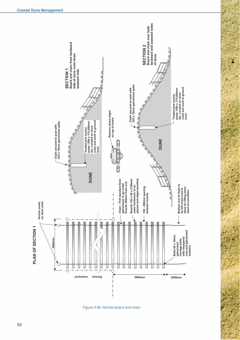
Coastal Dune Management
62
Figure 4.9b Vehicle board and chain

Dune Reconstruction and Protection
63
Vehicular board and chain accessways can be
provided on the seaward slope, crest and landward
slope of the foredune or wherever additional traction
for vehicles is required. Recommended designs
provide high strength to accommodate the heavy
loads.
The risk of board breakage is minimised if thedistance between the chains matches the track
width of the vehicles that use the accessway most
frequently. The objective is to have the chains bear
much of the vehicle load, rather than the boards
doing so alone.
Woodchip, Mulch and Sawdust Accessways:Woodchip, mulch and sawdust can be used on
access tracks that are level, where vegetation
disturbance has been minimal and where sand driftis not occurring. It should be laid at a thickness of
approximately 75-100mm. This allows it to pack
firmly onto the sand base. If spread too thinly it will
break up and with the movement of the sand will
be buried and completely lost. Once laid it provides
a comfortable walking surface and grass can grow
amongst the chip, helping to bind it. It also
enhances the aesthetic appeal of vegetated dunes.
Mulch and sawdust are cheap and easy to applyand also impart a more natural appearance to an
accessway (Figure 4.10a). It tends to be shortlived,
requiring replacement and is therefore only really
suited to low traffic areas.
Woodchip and mulch should always be selected
carefully to avoid coarser, angular and poorly sorted
material that is uncomfortable or dangerous to walk
upon.
Crushed sandstone: Crushed sandstone can be
used to provide a reasonably erosion resistant track
surface on low gradient accessways landward of
the foredune (Figure 4.10b). It should not be used
on steep dune faces, as rainstorms will wash the
fines away, leaving a very rough surface
unacceptable to bare footed pedestrian traffic. It is
also not suitable for areas experiencing frequent
erosion or accretion. Maintenance costs are oftenhigh.
Conveyor (holey) belt: An accessway surface with
considerable potential is a conveyor belt that has
been recycled from use in collieries. It can be
obtained in different widths up to 1.4 metres. Holes
are stamped through it prior to use, to facilitate
drainage and maintenance lifting (Figure 4.10c). It
is very easy to lay and is much cheaper than board
and chain. It is also well suited to temporary useand subsequent removal, for example during a surf
carnival. Its flexibility allows it to conform closely to
undulating dune surfaces and it can be cut easily
to suit turns or corners.
It appears suitable for pedestrians on grades up to
1 in 14. This gradient can also be negotiated by
wheel chairs. However on steep slopes it may
become slippery if a thin layer of sand accumulates
on its surface. Attaching additional 100mm wide
strips as step treads 200mm to 300mm apart on
steeper slopes provides a more secure footing.
Steeper grades (up to 1 in 4) have been usedsuccessfully by vehicles. On steeper slopes it can
also be anchored using 500mm long D-bars.
Its main disadvantage is that it is only 1.4m wide.
This is a little narrow to allow two people to pass
readily; on higher usage accessways two strips may
need to be laid beside each other. Its main use so
far has been to provide 4WD access to some North
Coast beaches, although an extended trial with
pedestrians has also proved successful. It is nomore slippery than timber when wet, and it has not
generated any user complaints about being hot to
walk upon.
Asphalt, concrete and paving stones: Rigid
materials such as these can provide very durable
surfaces, but they are really only suited to very
heavily trafficked areas that are reasonably stable
(Figures 4.10d,e). They should not be used in
exposed or sloping areas as they can be buried bydrifting sand, initiate erosion of the dunes by
concentrating runoff, or be undermined and
damaged by wind and waves. They can also
become slippery when wet and an artificial
appearance may be a significant aesthetic
distraction.
They can be useful in hind dune areas where an
accessway leads to a viewing platform. Here they
provide excellent surfaces for wheelchair access,but may also attract cyclists and skateboarders. In
these circumstances width and sight distances
need careful consideration to minimise the risk of
collisions between users.
Figure 4.10a
Low traffic
accessways
lend themselves
to woodchip
surfaces.

Coastal Dune Management
64
4.7.6 Steps and stairs
These should be avoided if possible as they are
generally not favoured by users and can become
relatively expensive structures, both to construct
and maintain. Designs should address the risks of
erosion by wind, runoff and storm waves. Council
approval will invariably be required.
In low traffic areas flights of log terraces may be
sufficient to facilitate access across short slopes.
Risers are constructed with treated timber logs or
railway sleepers (Figure 4.11a). In these situations
sand or other material is placed behind the timber
to act as a step (Figure 4.11b). Risers should be
anchored firmly, preferably by driving reinforcing
rod or galvanised pipe through them into the ground
(Figure 4.11c). Round treated logs should beavoided, as they can become very slippery when
covered with sand.
Figure 4.11a Log terrace provides
access in an area of moderatetraffic.
Figure 4.11b Timber steps provideaccess across foredune, protecting
vegetation.
Figure 4.10c Recycled conveyor belt
provides flexible, durable surfacesuitable for disabled access.
Figure 4.10e Asphalt provides access to ahind dune crest; bare sand extends to the
beach.
Figure 4.10b Crushed sandstone surfaceprovides disabled access and blends with
vegetation.
Figure 4.10d Pavers provide durable and
attractive access through hind dune areas.
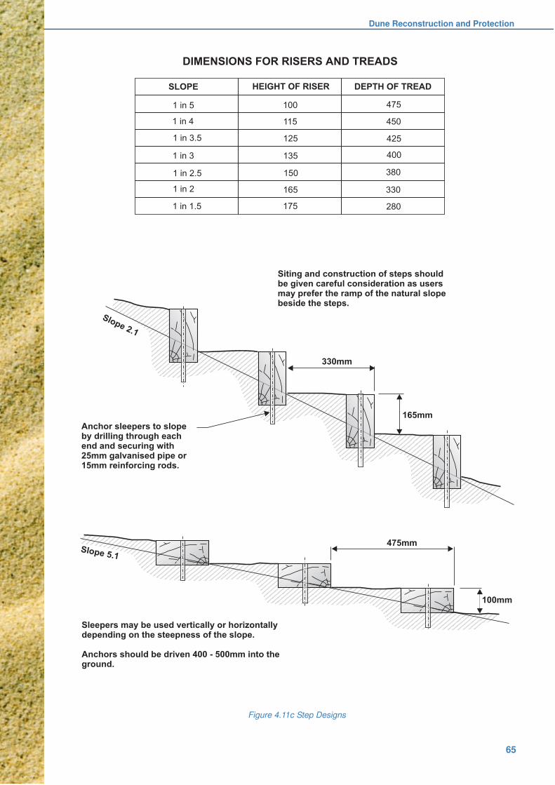
Dune Reconstruction and Protection
65
Figure 4.11c Step Designs
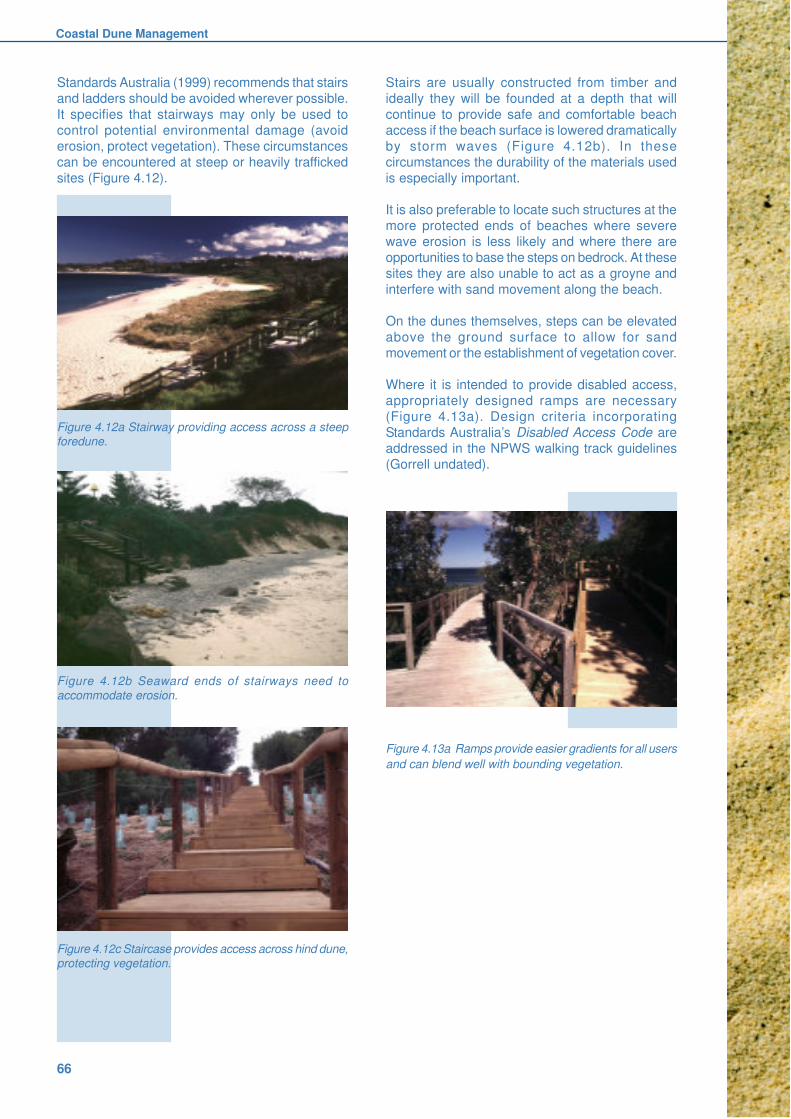
Coastal Dune Management
66
Standards Australia (1999) recommends that stairs
and ladders should be avoided wherever possible.
It specifies that stairways may only be used to
control potential environmental damage (avoid
erosion, protect vegetation). These circumstances
can be encountered at steep or heavily trafficked
sites (Figure 4.12).
Stairs are usually constructed from timber and
ideally they will be founded at a depth that will
continue to provide safe and comfortable beach
access if the beach surface is lowered dramatically
by storm waves (Figure 4.12b). In these
circumstances the durability of the materials used
is especially important.
It is also preferable to locate such structures at the
more protected ends of beaches where severe
wave erosion is less likely and where there are
opportunities to base the steps on bedrock. At these
sites they are also unable to act as a groyne and
interfere with sand movement along the beach.
On the dunes themselves, steps can be elevated
above the ground surface to allow for sand
movement or the establishment of vegetation cover.
Where it is intended to provide disabled access,
appropriately designed ramps are necessary
(Figure 4.13a). Design criteria incorporating
Standards Australia’s Disabled Access Code are
addressed in the NPWS walking track guidelines
(Gorrell undated).
Figure 4.12a Stairway providing access across a steep
foredune.
Figure 4.12b Seaward ends of stairways need to
accommodate erosion.
Figure 4.12c Staircase provides access across hind dune,
protecting vegetation.
Figure 4.13a Ramps provide easier gradients for all users
and can blend well with bounding vegetation.
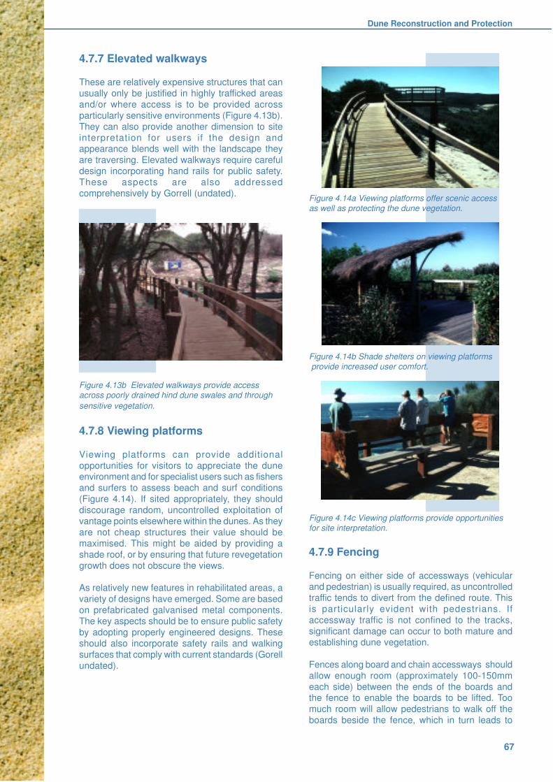
Dune Reconstruction and Protection
67
4.7.7 Elevated walkways
These are relatively expensive structures that can
usually only be justified in highly trafficked areas
and/or where access is to be provided across
particularly sensitive environments (Figure 4.13b).
They can also provide another dimension to site
interpretation for users if the design andappearance blends well with the landscape they
are traversing. Elevated walkways require careful
design incorporating hand rails for public safety.
These aspects are also addressed
comprehensively by Gorrell (undated).
Figure 4.13b Elevated walkways provide access
across poorly drained hind dune swales and through
sensitive vegetation.
4.7.8 Viewing platforms
Viewing platforms can provide additional
opportunities for visitors to appreciate the duneenvironment and for specialist users such as fishers
and surfers to assess beach and surf conditions
(Figure 4.14). If sited appropriately, they should
discourage random, uncontrolled exploitation of
vantage points elsewhere within the dunes. As they
are not cheap structures their value should be
maximised. This might be aided by providing a
shade roof, or by ensuring that future revegetation
growth does not obscure the views.
As relatively new features in rehabilitated areas, a
variety of designs have emerged. Some are based
on prefabricated galvanised metal components.
The key aspects should be to ensure public safety
by adopting properly engineered designs. These
should also incorporate safety rails and walking
surfaces that comply with current standards (Gorell
undated).
4.7.9 Fencing
Fencing on either side of accessways (vehicularand pedestrian) is usually required, as uncontrolled
traffic tends to divert from the defined route. This
is particularly evident with pedestrians. If
accessway traffic is not confined to the tracks,
significant damage can occur to both mature and
establishing dune vegetation.
Fences along board and chain accessways should
allow enough room (approximately 100-150mm
each side) between the ends of the boards andthe fence to enable the boards to be lifted. Too
much room will allow pedestrians to walk off the
boards beside the fence, which in turn leads to
Figure 4.14a Viewing platforms offer scenic access
as well as protecting the dune vegetation.
Figure 4.14b Shade shelters on viewing platforms
provide increased user comfort.
Figure 4.14c Viewing platforms provide opportunities
for site interpretation.
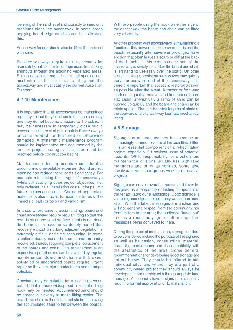
Coastal Dune Management
68
lowering of the sand level and possibly to sand drift
problems along the accessway. In some areas
applying board edge mulches can help alleviate
this.
Accessway fences should also be lifted if inundated
with sand.
Elevated walkways require railings, primarily for
user safety, but also to discourage users from taking
shortcuts through the adjoining vegetated areas.
Railing design (strength, height, rail spacing etc)
must minimise the risk of users falling from the
accessway and must satisfy the current Australian
Standard.
4.7.10 Maintenance
It is imperative that all accessways be maintained
regularly so that they continue to function correctly
and they do not become a hazard to the public. It
may be necessary to temporarily close public
access in the interest of public safety if accessways
become eroded, undermined or otherwise
damaged. A systematic maintenance program
should be implemented and documented by the
land or project manager. This issue must beresolved before construction begins.
Maintenance often represents a considerable
ongoing and unavoidable expense. Sound project
planning can reduce these costs significantly. For
example minimising the length of accessways
(while still satisfying other project objectives) not
only reduces initial installation costs, it helps limit
future maintenance costs. Choice of appropriate
materials is also crucial, for example to resist theimpacts of salt corrosion and vandalism.
In areas where sand is accumulating, board and
chain accessways require regular lifting so that the
boards sit on the sand surface. If this is not done
the boards can become so deeply buried that
recovery without disturbing adjacent vegetation is
extremely difficult and time consuming. In some
situations deeply buried boards cannot be easily
recovered, thereby requiring complete replacementof the boards and chain. This replacement is an
expensive operation and can be avoided by regular
maintenance. Board and chain with broken,
splintered or undermined boards require urgent
repair as they can injure pedestrians and damage
vehicles.
Crowbars may be suitable for minor lifting work,
but if burial is more widespread a suitable lifting
hook may be needed. Accumulated sand shouldbe spread out evenly to make lifting easier. The
board and chain is then lifted and shaken, allowing
the accumulated sand to fall between the boards.
With two people using the hook on either side of
the accessway, the board and chain can be lifted
very efficiently.
Another problem with accessways is maintaining a
functional link between their seaward ends and the
beach, especially after severe or prolonged wave
erosion that often leaves a scarp or cliff at the backof the beach. In this circumstance part of the
accessway is simply lost; often the board and chain
is left hanging uselessly over the scarp. On other
occasions large, persistent swell waves may quickly
bury the seaward end of the accessway. It is
therefore important that access is restored as soon
as possible after the event. A tractor or front-end
loader can quickly remove sand from buried board
and chain; alternatively a ramp of sand can be
pushed up quickly and the board and chain can berelaid upon it. The non-boarded lengths of chain at
the seaward end of a walkway facilitate mechanical
lifting.
4.8 Signage
Signage on or near beaches has become an
increasingly common feature of the coastline. Often
it is an essential component of a rehabilitation
project, especially if it advises users of potentialhazards. While responsibility for erection and
maintenance of signs usually lies with land
managers and other authorities, some also
devolves to volunteer groups working on coastal
projects.
Signage can serve several purposes and it can be
designed as a temporary or lasting component of
the rehabilitated dune landscape. Good signage isvaluable; poor signage is probably worse than none
at all. With the latter, messages are unclear and
will not generate respect from the community nor
from visitors to the area; the audience “tunes out”
and as a result may ignore other important
messages being conveyed to them.
During the project planning stage, signage matters
to be considered include the purpose of the signage
as well as its design, construction, material,durability, maintenance and its compatibility with
the aesthetics of the area. Some general
recommendations for developing good signage are
set out below. They should be tailored to suit
individual sites and where they are part of a
community-based project they should always be
developed in partnership with the appropriate land
manager. All councils have a signs policy, usually
requiring formal approval prior to installation.
Dune Reconstruction and Protection
69
4.8.1 Purpose: why is it needed?
Most signage is used to enhance public safety,
to control undesirable behaviour or to educate
the community by raising awareness and
understanding. Unnecessary signage is poor
signage.
Safety: Minimising public risk is an ongoing task
for land managers. Protection of the public interest
or satisfying a duty of care may impose a legal
requirement to erect warning signs alerting beach
users to potential dangers (Figure 4.15).
These may relate to semi-permanent natural
phenomena (deep or shallow water, rip currents);
to temporary natural hazards (fallen trees,occurrence of high seas, a scarp cut into the dune
face by storm waves); or to hazards that may arise
from human intervention in the landscape (uneven
surfaces, risk of theft, night closure).
There may also be temporary emergency signage,
perhaps accompanied by fencing, and erected by
the Police, State Emergency Services (SES),
Council or other authority, effectively excluding the
public from a defined site or area.
Information: Other signs serve to control public
movement and behaviour within a longer time
frame. This may be to make it easier for users to
find their way to the beach, to encourage use of
newly established facilities or to protect sensitive
areas and resources. They may also directly or
indirectly raise community awareness and
understanding of the local environment and of
efforts to protect or enhance it.
4.8.2 Design
This should be arresting whatever the purpose.
Clarity of image and lettering is essential. Signs
must be clearly discernible from a distance of at
least five metres. Within any one area some
uniformity in design is encouraged.
Where a sign must be obeyed in the interests ofsafety the picture and/or wording must be
unequivocal; there must be no likelihood of
misinterpretation. At many localities signs may also
need to be multilingual. In some instances
universally recognised symbols without lettering
may be appropriate. Council sign policies will
specify state and local requirements.
Signs seeking to deter nominated actions shouldbe worded positively and if possible they should
be accompanied by an explanation for the
constraint. “Please stay on path; dune rehabilitationFigure 4.15 Examples of good signage

Coastal Dune Management
70
in progress” is more likely to generate compliance
than “Keep out” or “No beach access”. Informative
signage should be clear, concise, simple to
understand, and appealing (Figures 4.15).
4.8.3 Position
Consideration must be given to the location of a
sign to ensure its visibility without compromising
public safety. While needing to be visible to passers-
by there are also minimum clearances from
walkways, roadways and services to be determined
before erecting any sign. These should be readily
available from land managers and local authorities.
Where signs need to be erected at erosion prone
sites, care should be taken to minimise loss, and if
damaged or removed they should be repaired or
replaced promptly.
4.8.4 Materials
There is a great variety of materials to choose from
in planning signage. The final choice will reflect therelative importance of factors such as prominence
and durability, as well as production, installation and
maintenance costs. Local NPWS or council offices
can provide advice on contemporary preferences
and pricing (eg. NPWS undated). Ongoing sign
maintenance must always be considered.
Timber: The painted, treated-timber Dune Care
signs have become a distinctive feature at many
beaches but they become shabby unless repainted.Seasoned hardwood makes strong, durable signs
that are routed easily. They are vandal resistant
and repairable. Unpainted treated pine can be very
effective with routed lettering and it usually blends
well with the landscape. It is not as hard or as stable
as hardwood but it is lighter and easier to transport.
Timber shelters protecting multiple signs are very
effective in high usage areas and are often very
attractive - as in a number of National Parks (Figure4.16).
Composition board made from wood fibre and
resin is easily worked but it must be sealed
effectively for outdoor use. It is easily vandalised.
Metal: Reinforced aluminium is the preferred
material for durable metal signs within coastal
environments. Screen-printed aluminium readily
incorporates graphics but it is relatively expensive,particularly for single orders. Wording can be
obscured by condensation if perspex or lexan
covers the sign.
Plastic lettering and symbols are now used in
many signs and these may prove to be the most
durable of all. Some sign-writers are offering twelve-
year guarantees for these materials.
Many signs now use a combination of materials
and technological advances are constantly
providing new products with improved durability atlower prices. It is recommended that the local
NPWS or council office is contacted regarding
favoured materials.
Figure 4.16 Shelters protect signs from rain and direct
sunlight and can encourage site interpretation by
visitors.

Dune Reconstruction and Protection
71
4.8.5 Stability
Signs also need durable supports. Powder-coated
galvanised pipe, shaped appropriately, or sturdy
treated pine posts are preferred. Most signs have
their supports set well into the ground - as much
as a third or even half of the total height. In
unconsolidated sand particularly, large signs willrequire stabilising below the surface, for example
with concrete. The difficulty of replacing signs with
massive footings that are badly damaged by
vandalism should also be considered.
4.8.6 Permanence
The durability of signs depends on the materials
chosen, the degree of exposure (eg. fading anddiscolouration from ultra-violet rays) and the
incidence of vandalism. Where vandalism (either
defacing of signs or physical damage) occurs,
prompt repair is essential, however frustrating. If
ongoing repair is judged to be too great a burden,
consideration should be given to removing the sign
completely.
4.8.7 Temporary signs
Local authorities may erect temporary signs during
emergencies or to warn beach users of temporary
hazards. Other temporary signs might target a
particular project or even an afternoon working-bee.
On the Central Coast, the latter have proved very
effective in explaining the work being undertaken
and in encouraging new people to join the group.
With all temporary signage it is essential that it be
removed as soon as its relevance is lost.
4.8.8 Responsibilities
Signs should never be erected without formal
approval of the land manager. Groups and/or land
managers could be liable for personal injury arising
from a poorly constructed or erected sign.
When considering signage in areas that are being
revegetated care should be taken to ensure thatany signs erected will not be obscured by growth
of plants. As with new plantings, new signs should
not obscure lines of vision (sight lines) for cycle
and walkways. Weed control may also be required.
Any group deciding to make or purchase an
informative sign should also be sure the decision
has been reached democratically, as the group will
then have a sense of ownership and ongoing
maintenance will be easier.
4.8.9 Costs
The cost of signs sometimes seems prohibitive but
experience indicates that it is better to spend a large
sum on a sign that will give years of service than to
economise with a cheaper item. Provision for
signage costs should be made when applying for
grants.
4.8.10 Number: how many signs?
Beware “sign fever”. Too many signs will not be
effective and adds unnecessarily to both installation
and maintenance costs. They will not be read and
they can destroy the whole ambience of an area.
4.8.11 Maintenance of signs
As is the case for other structures, it is imperative
that signs be well maintained. It should also be
noted that some land managers may be reluctant
to accept responsibility for maintenance of a sign
erected by a group. Repair or have repaired any
damaged sign as soon as possible. Sometimes a
touch-up with suitable paint will give a sign an
appearance of freshness.
If at all possible, remove all traces of graffiti quickly.
As a last resort remove a damaged sign.
4.9 References and further reading
Buchanan R.A. 1989, Bush Regeneration: Recovering
Australian Landscapes, TAFE NSW, Sydney.
Gorrell S. undated, Walking track constructionguidelines, NSW National Parks and Wildlife Service
(c. 1996).
NPWS undated, Signage Design Standards, National
Parks and Wildlife Service, Sydney.
Standards Australia 1992, Disabled Access Code,
Australian Standard 1428
Standards Australia 1992, Fixed platforms, walkways,
stairways and ladders - Design, construction andinstallation, Australian Standard 1657.
Standards Australia 1999, Walking tracks Part 2:
Infrastructure design, Draft Australian Standard 99196
(to be AS2156.2).

Coastal Dune Management
72

Weeds
73
5. WEEDS
5.1 What are weeds?
Weeds are pests that cause a range ofenvironmental, social and economic problems.There are many definitions of weeds: from a plantgrowing where it is not wanted, to a plant for whichno economic use has yet been found.
Along the coastline, weeds are best thought of asplants that do not occur naturally in the area underconsideration and which pose a threat to the valuesof that area. The more threatening weedsreproduce readily and can spread quickly from theiroriginal source or point of introduction to invadeother areas, damaging natural ecosystems that aredesired to be weed free.
The term “noxious weed” is also used whendiscussing weeds. This has a specific meaning andrefers to weeds listed under the Noxious WeedsAct 1993. Control of noxious weeds is a legalobligation of landowners with various actionsrequired depending on the classification. Controlis enforced by local authorities - either by localcouncils or by regional weed authorities.
Successful management of NSW coastal duneenvironments requires attention to both noxiousweeds and a wide range of other weeds. At somesites, where physical degradation is quite minor, aweed management program may be the onlyelement required for successful dune rehabilitation.
Weeds can include both exotic (non-Australian) andnative flora. For example, Bitou Bush(Chrysanthemoides monilifera ssp rotundata) is aSouth African shrub, which is now prolific alongmost of the New South Wales coastline. Coastaltea tree (Leptospermum laevigatum) is a nativeplant that occurs naturally from the mid-north coastto southern Australia. It was commonly used fordune stabilisation on the Far North Coast but hassubsequently established and spread in a numberof other areas in an unwanted manner.
Weeds can have a variety of vegetative forms. Theycan be shrubs (eg. Bitou Bush), trees (eg. CoralTree), vines (eg. Madeira vine), herbaceous plants(eg. Cape Weed) or grasses (eg. Spiny Burr Grass).
5.2 Impacts of weeds
Weeds cause many problems in coastal and otherenvironments because they often grow faster than
native plants and successfully compete for sunlight,
water, nutrients and pollinators. They can prevent
or interfere with natural regeneration and planned
revegetation programs.
Their capacity to establish and spread leads to
invasion and displacement of native plant
communities, thereby reducing biological diversity.
Floristically and structurally diverse natural
vegetation can be changed dramatically to a much-
simplified state where one or several weeds may
dominate. Examples include monospecific stands
of Bitou Bush (Figure 5.1) or ground covered byAsparagus Fern. Native fauna are also adversely
affected by the loss of plants that provide shelter,
food and nesting habitat, or by other animals that
thrive in response to the changed conditions.
Other weeds are illustrated in Attack of the Killer
Weeds (Williams & Fiedler 1998)
Figure 5.1a: Monoculture of Bitou Bush on
foredune at Stuarts Point
Figure 5.1b: Hummocky terrain induced by Bitou
Bush, Birubi Point
Figure 5.1c: Bitou Bush flower and fruit

Coastal Dune Management
74
Weeds may also directly threaten rare or important
individual species and communities. For example,
in the Coffs Harbour area an endangered prostrate
plant Zieria prostrata is threatened by Bitou Bush
and a number of significant littoral rainforest
communities are threatened by Bitou Bush,
Asparagus Fern, Lantana and other weeds.
Other potential weed problems include:
n providing habitat or a food source for feral
animals
n altering dune sand mobility by changing the
vegetation cover eg. creation of a weed
monoculture
n increasing the cost of servicing beach
accessways and maintaining weed-free
plantings in revegetation programsn increasing fire risk by raising available fuel
levels in fire danger periods
n reducing visual amenity and aesthetics of
natural landscapes
n financial cost of control programs
5.3 Introduction and spread
Weeds are introduced to the natural environment
either accidentally, for example by movement ofcontaminated soil containing weed seeds, or
through deliberate introductions for agriculture,
horticulture or utility, for example early plantings of
Bitou Bush for dune stabilisation.
Weeds have often escaped from their original
source and spread into the natural environment.
Many weeds in coastal dune ecosystems have their
origins in nearby gardens.
The spread of weeds is often favoured by
disturbance. Disturbances include physical
disruption of the environment such as constructing
and maintaining roads, tracks and powerlines,
changes in surface runoff and drainage, and fire.
These create conditions that often favour weeds
over native plants such as higher light levels
adjacent to roads or increased soil nutrients
resulting from urban runoff.
The seeds of weeds are usually easily transported
and many weeds have parts such as bulbs, corms,
leaves and stems from which reproduction occurs.
There are also numerous ways in which weed
propagules can be dispersed. For example, wind
is very effective in dispersing seeds of the daisy
family and many grasses, while water is very
effective along drainage lines and down broader
slopes. Animals such as foxes and birds, bothnative and introduced, are also effective dispersal
agents with seeds stuck to fur or feet or being
transferred through consumption and later
defecation. Humans are important too, through
attachment of weed propagules to clothing,
footwear, machinery and vehicles and by
movement of contaminated soil.
Dumping of garden waste at the edges of
bushland is a major source of weed infestations
and is particularly serious as it allows theestablishment of many weeds that would
otherwise have no means of spreading.
5.4 Management
Clear objectives must be set when deciding to do
something about weeds in a particular area.
Sometimes weed control has been undertaken
without a complete understanding of the local
environment or of the requirements for follow-upor maintenance works to prevent re-invasion. In
many cases the initial successes have not been
able to be sustained and resources have been
wasted.
In many instances the objective of simply controlling
weeds is too narrow and fails to consider broader
environmental requirements. Controlling weeds
should be seen as part of a wider obligation to
retain, protect and restore natural duneecosystems.
The following principles should be considered when
planning a weed management program.
a) Understand the nature of the problem.
n what weed(s) are present?
n where do they occur?n at what densities do they occur?
n what threats do they pose?
n why are the weeds there; are they a
symptom of a larger problem?
n are the weeds serving an ecological function
of value?
n what other land management issues are
there?
b) What can be done about the problem?
n who owns or manages the land; are theydoing anything or do they have any plans toaddress the problem?
n are there any groups, organisations orindividuals who are interested or can help?
n are suitable control techniques available?n what are the effects of the controls (positive/
negative)?n how much can be done?n who will do the work and when? What is the
best time of year?
n are special skills, methods or equipment
required?
Weeds
75
n what is the weed’s classification? This may
determine the type and amount of funding
that can be sought for a control program.
n what happens after initial control efforts, will
other (worse) weeds invade?
n is revegetation required or is natural
regeneration adequate?
c) Getting results.
Preventing new infestations is usually cheaper and
more successful than dealing with established
infestations. This requires an awareness of weeds
and monitoring of the area to detect new outbreaks.
Generally work in lightly infested areas first. This
will help contain the spread of weeds, is cheaper
and there is a higher chance of success.Participants in the program will feel a sense of
achievement. Heavily infested areas require more
work over a longer period and some may have
changed substantially so that re-establishing
original native vegetation is unrealistic.
Decide whether to treat priority weeds in an area
or systematically treat all weeds. Both approaches
can be valid and depend on the nature of the
infestations, the threats posed, the condition of thesurrounding vegetation and the desired outcome.
Set realistic limits. It is better to concentrate
resources to achieve fewer outcomes than to
spread too thinly and only partially complete more.
Break up the area into manageable sections so
what initially may be daunting can be achieved by
working a section at a time. Allocating workers to a
given area can build ownership and pride in their
achievement.
Work together. Some of the best work is done
where groups, individuals and land managers come
together and provide a range of expertise, labour
and equipment to deal with problems.
Think ahead. Most weed work requires follow-up
to deal with re-infestation from the soil seedbank
or dispersal from nearby areas. How big an areacan be realistically maintained in the longer term?
Who will do this? If revegetation is required, then
seed collection and propagation often needs to
commence well before weed control is
commenced.
Be aware that other weeds may invade or colonise
an area after initial weeds are removed. This needs
to be planned for.
Be flexible. Use appropriate control techniques for
the particular weed in that situation. What works in
one area is not always applicable everywhere else.
Community support and awareness. This is
important to let people know what the problem is,
what is being done about it and how they could
help. This can be done with signs, brochures,
posters, newsletters and media (radio, TV,
newspapers), and through interaction with the wider
community and passers-by at working bees and
field days.
Document results. Take before, during and after
photographs of the work area and record what has
been done. This is often necessary to remind
yourself and others of how much has been
achieved. Photographs should be taken from the
same fixed, marked point each time and a
permanently fixed reference object should be
included in each image frame.
d) Following a plan
It is essential to have a plan that considers all of
the matters itemised above. A plan can be a very
simple document, sometimes one page, or a very
detailed document depending on the scale and
complexity of the problem (see Chapter 3 for more
detailed discussion of the value of proper planning).
An approved plan will ensure that everyone involvedknows what is going to be done, that it has backing
from the land manager, that a consistent approach
will be adopted and that if key people move on then
the program still has a high chance of succeeding.
Good planning will help to achieve the objectives
of other weed management initiatives. These may
be contained in a weed control strategy prepared
by the local council, they may be contained in a
state strategy such as the NSW Bitou Bush Strategy(NPWS 2001), or they may relate to higher level
plans such as the national Bitou Bush and
Boneseed Strategic Plan (A&RMC of Aust. & N.Z.
2001). Good planning will also encourage
compliance with Best Practice Management
guidelines (eg.Vranjic 1999).
The planning process should also identify other
issues that may need consideration. This shouldinclude assessment of the wider ecological role
played by the pest species. For example, some
weeds provide shelter for endangered species from
predatory feral animals. Weeds may also form part
of the overall vegetation canopy, preventing
intrusion of salt laden winds into sensitive
ecosystems. Abrupt removal of the weeds in these
circumstances could have adverse consequences.
When threatened species are present, the impactof weed control on those species needs to be
considered in terms of the Threatened Species
Conservation Act. NPWS can provide advice on
Coastal Dune Management
76
the requirements for impact assessment. Other
environmental protection instruments also preclude
removal of vegetation without prior environmental
impact assessment and formal approval. State
Environmental Planning Policy 14 (SEPP 14
Coastal Wetlands) and SEPP 26 (Littoral
Rainforest) are two examples of such restrictions.
5.5 Control techniques
Various control techniques are available for treating
weeds. These are usually grouped into physical,
chemical and biological controls.
Physical weed control techniques can range from
use of machinery for clearing major infestations to
very labour intensive techniques such as theBradley method (Buchanan 1989).
Chemical control techniques can also range from
the broad-scale use of spray machinery including
aircraft to the selective but labour intensive use of
backpack sprays or stem injection implements.
Although attracting growing interest, application of
biological controls by pathogenic diseases or
insects is only available for a very limited numberof plants with variable success.
Choice of control techniques depends on:
n weed growth stage and the size and nature
of the infestation
n presence of non-target plants and animals
and the effect of control technique on them
n site characteristics such as soil type slope,
erodibility, access, exposure and prevailingwinds
n legal requirements governing the use of
herbicides
n available equipment
n expertise and experience of available labour
n cost
n personal preferences
New control methods and products are
constantly being introduced. OccupationalHealth and Safety standards, especially for
handling herbicides and pesticides, are also
becoming increasingly rigorous.
Advice on specific controls for particular weeds can
be found in the list of references at the end of this
chapter and by contacting local council weed
officers, bush regenerators and National Parks and
Wildlife Service staff.
Weed control is moving towards an integrated
approach where the appropriate control technique
is used for a particular situation. Physical, chemical
and biological controls are used in a co-ordinated
way to provide the most effective control at the least
cost and to minimise off target impacts, whilst
retaining a stabilising vegetative cover on the
dunes.
5.6 Weeds occurring along thecoastline
The following is a list of weeds that are known to
occur on the NSW Coastline. Not all weeds are
present everywhere and some plants may behave
as weeds in one area and be relatively benign in
another area. There will be other weeds not on this
list such as newly emerging weeds or weeds that
are poorly known and/or restricted to small isolated
locations.
Acacia saligna Golden Wreath
Wattle or Willow
WattleAcetosa sagittata Turkey Rhubarb
Agave americana Yucca Plant
Ageratina adenophora Crofton Weed
Ageratina riparia Mist Flower
Ageratum houstonianum Blue Billy Goat
Weed
Anredera cordifolia Madeira Vine
Araujia hortorum Moth Plant
Arctotheca populifolia Cape Weed
Arundinaria spp. Bamboo
Asparagus aethiopicus Ground AsparagusAsparagus plumosus Climbing
Asparagus Fern
Baccharis halimifolia Groundsel Bush
Bidens pilosa Cobblers Peg
Bryophyllum delagoense Mother of Millions
Bryophyllum pinnatum Resurrection Plant
Buddleja madagascariensis Buddleja
Canna indica Canna Lilly
Cardiospermum grandiflorum Balloon Vine
Catharanthus roseus Madagascan
PeriwinkleCeltis sinensis Chinese Elm
Cestrum parqui Green Cestrum
Chloris gayyana Rhodes Grass
Chrysanthemoides monilifera
subsp. monilifera Boneseed
subsp. rotundata Bitou Bush
Cinnamomum camphora Camphor Laurel
Commelina benghalensis Hairy Commelina
Conyza albida Fleabane
Coprosma repens Marble Plant or
Mirror PlantCoreopsis lanceolata Coreopsis
Cortaderia selloana Pampas Grass
Cotoneaster spp. Cotoneaster
Crocosmia X crocosmiiflora Montbretia
Cynodon dactylon Common Couch
(native with weedy
characteristics)
Delairea odorata Cape Ivy
Desmodium uncinatum Silver Leaf
Desmodium
Weeds
77
Eragrostis curvula African Love GrassErythrina X sykesii Coral TreeEleusine indica Crows Foot GrassEuphorbia cyathophora Painted SpurgeEuphorbia paralias Coastal SpurgeFicus elastica Indian Rubber TreeFoeniculum vulgare FennelGazania rigens GazaniaGenista spp. BroomGladiolus gueinzii Coastal GladiolusGloriosa superba Glory LilyHydrocotyle bonariensis PennywortIpomoea cairica Mile a MinuteIpomoea indica Common Morning
GloryJuncus acutus Spiny RushLantana camara LantanaLeptospermum laevigatum Coastal Tea Tree
(native with weedycharacteristics onFar North Coastthat occursnaturally south ofNambucca)
Ligustrum lucidum Large-leavedPrivet
Ligustrum sinense Small-leaved PrivetLilium formosanum Formosa LilyLonicera japonica Japanese
HoneysuckleLupinus luteus LupinLupinus hirsutus LupinLycium ferocissimum BoxthornMacfadyena unguis-cati Cats Claw CreeperMacroptilium atropurpureum SiratroMelinis repens Red Natal GrassMyrsiphyllum asparagoides Bridal Veil CreeperNephrolepis cordifolia Fishbone Fern
(native plant withweedycharacteristics;does not naturallyoccur on coast)
Ochna serrulata Mickey MousePlant
Oenothera stricta Evening PrimroseOlea europea ssp africana African OliveOpuntia stricta Smooth Tree Pear
or Prickly PearPanicum maximum Guinea GrassParietaria judaica PellitoryPaspalum spp. PaspalumPassiflora edulis PassionfruitPassiflora foetida Stinking
PassionfruitPassiflora suberosa Corky PassionfruitPassiflora subpeltata White PassionfruitPennisetum clandestinum KikuyuPhyllostchys spp. BambooPhytolocca octandra InkweedPinus ellioti Slash PinePinus radiata Radiata PinePolygala myrtifolia Myrtle-Leaf
MilkwortPsidium cattleianum Cherry GuavaPsidium guajava Red GuavaPsidium littorale Yellow Guava
Pyrostegia venusta Golden Shower
Ranunculus repens Creeping Buttercup
Ricinus communis Castor Oil Plant
Rivina humilis Coral Berry
Rubus fruticosus Blackberry
Sansevieria trifasciata Mother in Law’s
Tongue
Schefflera actinophylla Queensland
Umbrella Tree
Schinus terebinthifolia Broad-leaved
Pepper Tree
Senecio madagascariensis Fireweed
Senna pendula var. glabrata Cassia or Winter
Senna
Setaria sphacelata Setaria or Pigeon
Grass
Solanum mauritianum Tobacco Bush
Solanum nigrum Blackberry
Nightshade
Solanum seaforthianum Climbing
Nightshade
Sorghum halepense Johnson Grass
Sporobolus indicus Parramatta Grass
Stenotaphrum secundatum Buffalo Grass
Syagrus romanzoffianam Cocos Palm
Tagetes minuta Stinking Roger
Tecoma capensis Cape Honeysuckle
Thunbergia alata Black-Eyed Susan
Tithonia diversifolia Japanese
Sunflower
Trachyandra divaricata Dune Onion Weed
Tradescantia fluminensis Wandering Jew
Tropaeolum majus Nasturtium
Watsonia meriana Watsonia
Wedelia trilobata Singapore Daisy
Zantedeschia stricta Arum Lily
Zebrina pendula Variegated
Wandering Jew
For additional information and illustrations, dunemanagers should consult Attack of the Killer Weeds(Williams and Fiedler 1998) distributed byCoastcare.
5.7 Three worst weeds of the NSWcoastline.
Many weeds have become strongly establishedalong the coastline. New weeds are beingintroduced to coastal bushland and most existingweeds are expanding their range. Conferring“worst” weed status on a plant gives regard to threemain factors; distribution, impact and difficulty ofcontrol. Local priorities may differ.
The 2000 NSW Dune Care Conference consideredthis question and because of geographic variationsprovided regional lists of weeds that were worsethan bitou or persistently replaced it after initialcontrol. From this and other information the threeworst weeds for the NSW coastline as a whole areBitou Bush, Asparagus Fern and Lantana. Allthree extend from the Far South Coast of NSWinto Queensland, occupy a wide range of habitatsand require repeated control. Bitou Bush andLantana are listed as “Weeds of National
Significance”.
Coastal Dune Management
78
5.7.1 Bitou Bush
Bitou Bush (Chrysanthemoides monilifera ssp
rotundata) is a South African shrub that was used
in NSW to stabilise sand dunes for over twenty
years. Its rapid growth rate and voluminous
production of long-lived, readily dispersed seeds
(up to 48,000 per plant) has facilitated its invasionof most of the NSW coastline. It has the capacity
to establish and dominate both disturbed and
undisturbed bushland and achieve over 90%
coverage in some areas such as parts of the Tweed
Coast. In recent years a more coordinated and
better resourced effort has begun to successfully
reduce the impacts of this plant in a number of small
areas. However, this still falls far short of what is
required, given the magnitude of the problem.
A NSW Bitou Bush Strategy provides the
framework for continuing control (NPWS 2001).
5.7.2 Lantana
Lantana (Lantana camara) is a scrambling or
climbing shrub that forms dense thickets. It is a
plant with many forms and varieties, often of
obscure origin. The most widespread pink floweredform was introduced into Australia from Europe in
the 1800s after more than a century of introductions
from South America into Europe. By the late 1800s
lantana was described as a very serious weed in
the Brisbane and Sydney areas. It is now found
from the south coast to northern Queensland with
scattered infestations in other states. It can become
the dominant plant in a wide range of habitats,
readily establishing and dominating the understorey
of disturbed forests and abandoned or poorlymanaged farmland. In coastal bushland it is
especially prevalent in sheltered hind dune and
headland vegetation, often growing with Bitou Bush
and replacing it in heavier shade conditions.
5.7.3 Ground Asparagus
Ground Asparagus (Asparagus aethiopicus) is a
low growing shrub from South Africa with sprawling
stems up to 2m long. Originally introduced and stillavailable as an ornamental plant, it has spread
rapidly in recent years and is now regarded as a
serious problem along the NSW coastline. It can
completely dominate the groundcover of dunal and
headland vegetation to the exclusion of other
vegetation. Control is slow and laborious and
continual follow up is required to prevent
reinfestation.
Agriculture & Resource Management Council(A&RMC) of Australia & New Zealand, Australian &New Zealand Environment & Conservation Counciland Forestry Ministers 2000, Weeds of NationalSignificance Bitou Bush and Boneseed Strategic Plan,National Weeds Strategy Executive Committee,Launceston.
Auld B.A. and Medd R.W. 1987, Weeds, Inkata Press,Melbourne.
Big Scrub Landcare Group 1998, Common Weeds ofNorthern NSW Rainforests, Big Scrub LandcareGroup, Mullumbimby.
Buchanan R. 1989, Bush Regeneration: RecoveringAustralian Landscapes, Sydney College of Technicaland Further Education.
Carolin R. and Clarke P. 1991, Beach Plants of SouthEastern Australia, Sainty & Associates, Potts Point.
Csurhes S. and Edwards R. 1998, PotentialEnvironmental Weeds in Australia, EnvironmentAustralia, Canberra.
Dyason R. (ed) 1989, Bitou Bush Control Handbook,NSW Agriculture and Fisheries, Soil ConservationService of New South Wales and NSW National Parksand Wildlife Service, Sydney.
Harden G.J. 1990-1993, Flora of New South Wales,(Volumes 1-4), New South Wales University Press,Kensington.
Lamp C. and Collet F.1989, Field guide to weeds inAustralia, Inkata Press, Melbourne.
McLoughlin L. and Rawling J. 1991, Making yourGarden Bush Friendly, McLoughlin-RawlingPublications.
NPWS 2001, New South Wales Bitou Bush Strategy,National Parks and Wildlife Service, Sydney.
NSW Agriculture 1999, Control of Noxious Weeds.
Panetta F.D., Groves R.H. and Shepherd R.C.H. 1998,The Biology of Australian Weeds, Volume 2, R.G.Richardson and F.J. Richardson Meredith, Victoria.
Parsons W.T. and Cuthbertson E.G. 2001, NoxiousWeeds of Australia, CSIRO Publishing.
Scanlon T. 2001, NSW North Coast Bitou BushManagement Strategy, North Coast Weeds AdvisoryCommittee.
Vranjic J. 1999, Best Practice Management Guide 3:Bitou Bush, Co-operative Research Centre for WeedManagement Systems, Australia, University ofAdelaide, Glen Osmond, South Australia.
Williams G. and Gerrand D. 1998, Coastline Survey ofAsparagaceae and other Environmental Weeds in theManning Valley, New South Wales, Greater Taree CityCouncil.
Williams S. and Fiedler M. 1998, Attack of the KillerWeeds, Coastcare, Department of Land and WaterConservation, Parramatta.
http://www.weeds.org.auhttp://weeds.merriweb.com.au/
5.8 References and further reading

Revegetation
79
6. REVEGETATION
6.1 Introduction
There are two major objectives in deciding to
revegetate a degraded dune:
n To restore and maintain biodiversity through
establishing native coastal vegetation
appropriate to its geographical area and its
position within the dune system -
vegetation that is self-sustaining with
minimal maintenance required once fully
established.
A healthy dune ecosystem will display a
range of plant communities and locally
indigenous species that reflect thegeographical distribution of species along the
coast, zonation within the dune system and
the age of the dunes. These communities
provide habitats for a diverse range of native
fauna, providing them with resources such
as food, breeding sites and protection from
predators.
n To provide sufficient plant cover to protect
fragile dunes against wind erosion. Species
that are native to the coastal dunes areadapted to survive the hostile environment
of drifting sand, strong winds, salt spray and
infertile soils. They provide long term stability.
Revegetation with native coastal species increases
wind protection for landward areas and for
infrastructure such as accessways, picnic areas
and car parks, as well as enhancing beach amenity.
Dune vegetation has the ability to:
n prevent wind erosion by decreasing wind
speed at ground level and by providing a
protective cover over the dune
n build up sand dunes and thereby increase
the sand reserve for storm waves
n reduce but not prevent damage from wave
erosion
n regenerate naturally after storm damage and
facilitate natural dune recoveryn tolerate gradual movements of the dunes
both vertically and horizontally
n provide habitat for native fauna
This chapter discusses revegetation in terms of four
themes:
n Planning and Development
n Implementation Methods
n Maintenancen Monitoring.
6.2 Guiding principles
Revegetation is a general term that includes
stabilising a land surface with plants that need not
be native. In coastal dune rehabilitation the
emphasis is on regeneration; re-establishing a
range of locally indigenous plants that would occur
normally in that environment. Another distinctioncan be made between natural and assisted
regeneration.
Natural Regeneration: Remnant native plants
already in the system can usually regenerate after
removal of weeds that compete for light, water and
nutrients. They can then improve in vigour, flower
and set seed. Following the disturbance of weed
removal, seeds in the soil seed bank may also be
stimulated to grow. These seeds may be the onlyrepresentatives of short-lived plants no longer
growing on the dunes. Plant species diversity is
increased. The aim with this approach is to restore
and maintain an ecosystem in which natural
regeneration can occur.
Assisted Regeneration: On highly disturbed
dunes, natural regeneration may occur too slowly
to prevent erosion, or too few species may be
represented. Planting species that are suited to thegeographical area and dune zone will speed the
regeneration process. Whether, when, how and
what to plant are discussed below.
The difference between rehabilitation and
restoration should also be noted. Restoration
means getting back to the “original” vegetation
cover. It is the ultimate goal but is much more
difficult to achieve. It relies on knowing thecharacteristics of the vegetation that existed before
degradation occurred. Getting back to that condition
is invariably very demanding of resources.
Rehabilitation is often an unavoidable but
worthwhile compromise. Successful rehabilitation
results in a stable landscape that blends with
surrounding areas but does not necessarily feature
the character of the original vegetation. It is a more
readily achieved condition and it can contributegreatly to the broader goal of conserving
biodiversity.
Use locally indigenous species: Locally
indigenous is a more specific term than native or
endemic. A locally indigenous species is
characterised by the slight variations that occur
between different plants of the same species from
area to area. These variations are a response to
different local physical conditions to which theplants have adapted (Coastcare undated).

Coastal Dune Management
80
The use of locally indigenous species has many
benefits in a revegetation project. Plants in their
natural communities have evolved to suit local
environmental conditions and have a desirably
broad genetic base (Mortlock 2000). Using plants
grown from local seed in revegetation complements
other native plants and animals in the area and is
thought to promote genetic and ecologicalsustainability in local vegetation. Better
performance of local plants in terms of survival and
growth has also been reported. It is therefore
important when collecting seed and other plant
material to do so as close to the rehabilitation site
as possible. For further information refer to the
FloraBank website and the Coastcare Factsheet
Locally Indigenous Species.
6.3 Planning and development
This section builds upon Section 3.3 on project
planning. It expands on some of the specific points
in relation to revegetation and highlights many of
the important questions to be answered through
comprehensive site assessment. As with the overall
project, planning is the most important part of a
revegetation exercise and if done well, is reflected
in the lesser degree of effort expended during a
project (Figure 6.1).
6.3.1 Assessing the site
After an initial site assessment has been made and
it has been established that some form of
revegetation is necessary, a number of more
specific questions need to be answered.
Is planting necessary? Look at what regeneration
is already happening. The history of vegetation on
the site may indicate whether natural regeneration
may occur. If the site has been infested with bitou
bush for thirty years, the soil seed bank of native
species will be low. If erosion is a concern, waiting
several years for natural regeneration may not be
wise. Conversely, some seed will germinate beston bare sand eg. Coastal Tea Tree (Leptospermum
laevigatum), Coastal Correa (Correa alba) and
Coastal Pelargonium (Pelargonium australe), so
some bare sand may be desirable. Consider if the
variety of species is suitable for the zone. Are
nearby native species likely to assist naturally by
shedding seed or spreading by vegetative means?
When selecting species to plant, it is often helpful
to examine old photographs and oral histories toestablish which plants were present before physical
degradation and/or bitou bush took over. This
information will augment any species selections that
are based on the geographical location of the site
and its biophysical zones (Fiedler in preparation).
Also note that some sites may be naturally bare
sand, eg. the small spits protruding from the
shoreline in the lee of near or offshore islands where
stabilisation and revegetation is unwarranted (seeSection 3.3.1).
What is the fire history of the site? How long ago
was the last fire? Which plants are likely to
regenerate after fire by resprouting or by smoke or
heat promoting seed germination? A fire may be
useful in stimulating germination of bitou seed,
Effo
rt
weed controlreplanting
embellishmentmaintenancemonitoring
communication
P r o j e c t t i m e s p a n
PLANNING &
DEVELOPMENT IMPLEMENTATIONMAINTENANCE &
MONITORING
weed controlreconstruction
fencingaccessways
plantingcommunication
consultationfact finding
site assessmentproject planningseed collection
propagationcommunication
weed controlreplanting
maintenancemonitoring
communication
Figure 6.1 Schematic representation of effort expended in a rehabilitation project.(Adapted from Greening Australia 1995)

Revegetation
81
shortening the bitou seedling removal process by
several years. Fires that are too frequent will destroy
native vegetation before it has had a chance to set
seed. Consult local authorities to find out when the
last fire occurred and observe the age of the native
vegetation. NPWS offices can provide advice on
ecological burns.
If planting is deemed necessary, consider the
following:
n which areas need planting? Consider the
site’s location on the coast and its position
within the dunes when compiling a list of
suitable species. Include as many species
as are needed to recreate an appropriate
vegetation structure (including trees, shrubs,
climbers, and ground cover plants).
n all emerging dune plants will need protection
from trampling. Provide for this before
planting as native coastal plants are sensitive
to disturbance around their roots. Dune
fencing and clearly defined tracks are
essential. Selective placement of fallen
branches can discourage walkers taking
short cuts.
n will tube stock be used?
n is brush matting an option?
n where will the plants be sourced?
n be aware of seasonal constraints - planting
success is more likely if plants go into moist
soil and the weather is not too hot and windy.
The best seasons generally are autumn andwinter.
n allow for maintenance of plantings - perhaps
watering, certainly weeding. Tree guards for
pest control and wind protection may also
be needed.
Many aspects of a revegetation project are season
dependent and will need long time frames.
Developing a calendar for a project is often a usefulway to help manage revegetation tasks (Figure 6.2).
The calendar can be developed within a broader
project time line (see Section 3.4.3) or it can be a
separate project schedule, provided it is not used
in isolation from other calendars. If grant funding
has been applied for, the availability of funds also
needs to be considered in developing a calendar.
If funds are unavailable until autumn for example,
there may not be sufficient time to grow tube stock
that will be ready to plant at the best time and itmay be necessary to postpone planting until the
following autumn.
Figure 6.2 Example of revegetation planner based on plantings of Coastal Wattle.
SPRING Monitor which plants are setting seed.
SUMMERCollect seed.
Store.OR
Treat seed andpropagate in trays.
AUTUMNDirect plant
seed in place.OR
Tube uppropagated seedlings.Y
EA
R 1
WINTERMonitor direct
planted seed area.OR Maintain tube stock.
SPRINGPlant tube stock
(if water is available)
SUMMER Collect seed. OR Maintain tube stock.
AUTUMNPlant tube stock(if water is limited)Y
EA
R 2
WINTER Monitor both direct planted & tubestock planted areas.

Coastal Dune Management
82
6.3.2 What plants go where?
Recognition of geographical area, zones, and plant
succession will guide selection of species for
planting. Choosing locally indigenous plants grown
from local plant material is the way to preserve
genetic integrity and maintain maximum
biodiversity. Choosing such plants means a projectwill have a better chance of success. Use of
inappropriate species is effectively introducing
weeds to a project area.
How local is local? Fleshy-fruited seeds such as
those from Lilly Pilly (Acmena smithii) are spread
far and wide by bats and fruit eating birds. However
plants such as Eucalypts may develop local
populations in small areas. Seed is not distributed
very far, so it should be collected from within a fewkilometres if possible or from similar communities
nearby.
Only a few plants grow along the whole length of
the NSW coast. Some coastal native plants have
a wide geographical distribution north to south;
others are native only to limited areas of the coast
(Figure 6.3).
The various zones of dunes are vegetated by plantsadapted to conditions in these zones. Typically
there are three zones that grade into each other.
These are:
n an unstable incipient foredune zone of
colonising herbs and grasses
n a semi-stable foredune zone of shrubs and
associated ground plants
n a stable hind-dune zone dominated by trees,
with an understorey of shrubs and groundplants
The combinations of plants and zones shown in
Figure 6.3 represent the typical assemblages that
are encountered. Some of these are quite strongly
defined. For example, while spinifex is characteristic
of the incipient foredune zone, flourishing with
prolonged exposure to sun, strong wind and
saltspray, plants of the littoral rainforest can onlysurvive in the protection of the hind-dune area.
Other associations are not as strong. Lomandra
spp.) and Guinea Flower (Hibbertia scandens) for
example can occasionally be found on incipient
foredunes.
Plant succession occurs when plants themselves
change growing conditions over time and compete
with each other. This is represented simplistically
in Figure 6.4, which assumes a continuing supplyof sand and no intervention by storms. Where
topography permits, littoral rainforest or open forest
may eventually develop to represent a climax
community with a complex structure of canopy,
shrub, climber and ground layer species. On the
incipient foredune spinifex grass, often the only
survivor in such conditions, will form the climax
community for that site and zone.

Revegetation
83
Figure 6.3 Typical geographical range of some common dune plants along the NSW coast.
Gwydir
Sho
alha
ven
TowambaR
River
Tuross
Namoi
Mehi
River
Macintyr
e
Pate
rson
Will ia
msR
HunterGle
nnies
River
Cly
de
R
R
Nep
ean
Riv
er
RiverCre
ek
R
River
Hastings
Manning
River
River
Peel
River
River
River
Macleay
Dumaresq
River
River
Rive
r
Richm
ondR
Cl a
rence
Nym
boid
aRiver
Coonabarabran
Dubbo
Bombala
Moruya
Gou lburn Kiama
Nowra
Windsor
Cessnock
Maitland
Newcastle
Wollongong
Tamworth
Walcha
Uralla
Armidale
Grafton
Nambucca Heads
Ballina
YambaMaclean
Bathurst
Bega
Cooma
Queanbeyan
Canberra
Sydney
Yass
Cowra
Orange
Wellington
Sou
th
Pac
ific
Oce
an
Q U E E N S L A N D
N S W
V I C
ACT
Eden
Batemans Bay
Narooma
Ulladulla
Raymond Terrace
LithgowGosford
Singleton
Tweed Heads
Scone
Murrurundi
Muswellbrook
Gunnedah
Narrabri
Port Macquarie
Taree
Forster
Kempsey
Coffs Harbour
Glen Innes
Inverell
Moree
Goondiwindi
Tenterfield
Lismore
Vig
na
mari
na
Can
av
ali
a r
ose
a
Ipo
mo
ea
bra
sil
ien
sis
Ca
rpo
bro
tus
gla
uce
sc
en
s
Sp
inif
ex
se
rice
us
Ac
acia
lo
ng
ifo
lii
Le
uc
op
og
on
parv
iflo
rus
Le
pto
sp
erm
um
la
evig
atu
m
Co
rrea
alb
a
Hib
be
rtia
sca
nd
en
s
Lo
ma
nd
ra l
on
gif
oli
a
Ban
ks
ia in
teg
rifo
lia
Eu
ca
lyp
tus
bo
tryo
ides
Ca
su
ari
na g
lau
ca
Cry
pto
ca
rya t
rip
lin
erv
is
Cu
pan
iop
sis
an
ac
ard
iod
es
Dio
sp
yro
s a
ustr
alis
Fic
us
ru
big
ino
sa
Cri
nu
m p
ed
un
cu
latu
m
Au
str
ofe
stu
ca
lit
tora
lis
Atr
iple
x c
inere
a
HIND DUNE FOREDUNE INCIPIENT FOREDUNE

Coastal Dune Management
84
Figure 6.4 Idealised vegetation succession on coastal dunes.
Hind dunes
Hind dunes
Hind dunes
Foredune
Foredune
Incipient dune
Incipient dune
Beach berm
Nearshore bar
Nearshore bar
Nearshore bar
Beach berm
Beach berm
Incipient dune
Foredune
Stage 1 - Grasses and creepers (primary species)
Stage 2 - Shrubs and short-lived trees (secondary species)
Stage 3 - Long-lived trees (tertiary species)

Revegetation
85
Secondary species are capable of withstanding
considerable exposure to strong winds and salt
spray, but are relatively intolerant of burial by sand
and are therefore dependent on the protection
afforded by primary species. They are suitable for
planting on coastal dunes landward from the
seaward toe of the foredune, but are most
commonly planted from the toe to the foredunecrest. In this position they provide protection to
tertiary species landward of the crest.
Most tertiary species are relatively intolerant of
strong winds and salt spray, and can be subject to
wind pruning and dieback when exposed to these
conditions. They cannot tolerate sand accretion.
Hence tertiary vegetation is dependent on the
combination of dune form and primary/secondary
zone vegetation for protection and survival.
Tertiary species are generally planted landward of
the foredune crest. A wide range of species is
adapted to growth on sandy coastal soils in this
location, with communities such as woodlands,
heathlands, swamplands and littoral rainforest all
found quite close to the coastline. The more
important species used in dune rehabilitation
programs include Coastal Banksia (Banksia
integrifolia), Swamp Oak (Casuarina glauca),Swamp Mahogany (Eucalyptus robusta),
Broad-leaved Paperbark (Melaleuca
quinquenervia), Bangalay (Eucalyptus botryoides)
and Tuckeroo (Cupaniopsis anacardioides).
In order to develop and maintain an
aerodynamically stable dune profile it is essential
to have secondary species evenly distributed over
the dune and it is preferable to plant tertiary species
in a similar pattern. However, clumped plantings oftertiary species, while not aerodynamically ideal,
can be considered if funds are limited or if
enhancement of visual amenity of the site is
important. They can also form a valuable seedbank.
Some guidance about the more common plants
that might be selected for planting is provided in
Sections 6.7 and 6.8.
A full range of species matched to location is
included in the NSW Coastal Plants Database
(Fiedler in preparation). Local experts in DLWC and
NPWS regional offices, Botanical Gardens, local
councils and established community groups can
also provide advice. The Australian Plants Society
(formerly SGAP - the Society for Growing Australian
Plants) may also be able to assist.
6.3.3 Seed collection
Seed collection requires consideration of the
following points:
n Permission should be obtained from the land
owner/manager, even for public land.
n Certification. A licence must also be obtainedfrom NPWS if any target species is listed on
Schedule 13 of the National Parks and
Wildlife Act or on the schedules of the
Threatened Species Conservation Act.
n Plan - select the target plants, establish their
locations, understand their fruiting times and
the logistics of gathering their seed. Collect
local progeny from naturally occurring
remnant vegetation as close as possible to
the project site.n Obtain good genetic quality for each species
by collecting from healthy, vigorous plants.
n Ensure that plants and populations are not
over exploited. Collect small amounts of
seed from a large number of individual plants
that are well separated from each other.
n Keep records of seed collection and storage.
If it is not possible to collect within close range of
the project site it is best to speak to the regionalNPWS office where staff should be able to provide
advice on the location of the next most appropriate
collection area. Usually, an area of similar
landscape and climatic characteristics should be
suitable.
Another important point to consider is how natural
the existing vegetation is at the site and other
nearby areas. Many large areas of coastal duneshave been modified ecologically by activities such
as sand mining. Often the vegetation found in these
areas is unnatural, with monocultures of species
such as coastal tea-tree and horsetail she-oak.
Seed should always be collected from areas that
are representative of the project site prior to
disturbance.
Further advice about seed collecting is available
from the FloraBank and Greening Australiawebsites. They provide detailed information about
codes of practice, methods, current suppliers and
other relevant organisations and links to other
useful websites.
Coastal Dune Management
86
6.3.4 Propagation
The main propagation methods are from seed,
cuttings and division. Many of the common coastal
plants will propagate readily from one or more of
these methods (Figure 6.6). Additional information
on plant propagation may be found in Buchanan
(1989) and in the Coastal Plant Propagation Manual(EnviTE 1998) which is available from local
Coastcare Facilitators or DLWC. Local specialists
from councils, NPWS, DLWC, Botanic Gardens and
nurseries can also be consulted.
6.4 Implementation
The planning and development phase of a
revegetation project is followed by implementation.Site preparation is the first task and at the very least
this will involve weed control, often removal of bitou
bush (chapter 5). Where degradation has been
especially severe, dune reshaping or reconstruction
may be necessary (chapter 4). However, because
sand is so easily worked there is usually little to do
in terms of soil preparation. Because of its high
porosity though, it is often best to wait for wetter
periods of the year when the sand is moist. This
will help reduce the amount of water needed in theearly stages of the project.
There are several revegetation methods to choose
from.
6.4.1 Revegetation techniques
Direct seeding: Seeds or individual fruits are
scattered in the area to be revegetated. This is
labour intensive and requires a nearby source ofparent plants. Germination of seeds of fleshy-fruited
plants is inhibited by the soft part of the fruit. Lilly
Pilly (Acmena smithii) and Seaberry Saltbush
(Rhagodia candolleana) are two examples. Crush
the fruit carefully to reveal the seeds and wash them
in several changes of water, then scatter the seeds
onto damp sand. Warrigal Spinach (Tetragona
tetragonioides) can be pruned lightly to collect
branches with mature berries and then thrown
about. Hardcoated seed such as from peas andwattles germinates quickly after scarification or heat
treatment. To increase the chances of germination
over a longer period, scatter half the seeds
untreated. These will become part of the soil seed
bank, germinating perhaps over the next 5-10
years. Treat the remainder to stimulate germination
and scatter onto damp sand immediately after
treatment. Beach Bean (Canavalia rosea) can be
established in this way. See section 6.7.1 for
planting Spinifex seed. Mulching or brush mattingmay be needed to conserve sand moisture levels.
Planting tube stock: Use of nursery-raised tubed
seedlings is the most common method of
establishing secondary and tertiary zone plants on
the foredune and hind dune. Planting should avoid
hot weather and drought periods. The best time is
from April through to September. Autumn plantings
are generally preferred, as there is an opportunity
for some growth following planting, followed bysettling-in during winter.
Estimate the area to be planted. Allow one plant
per square metre or more depending on species,
for instance one tree or shrub and one or two
grasses or ground level plants. Try to plant species
in proportion to how they would occur naturally and
stagger plants to mimic natural locations - avoid
planting in straight rows. Make use of natural
depressions when placing tube stock - even thesmallest will hold moisture. Try to establish
successional planting where possible and
appropriate.
Seedlings should be well watered some hours
before planting out so that the soil around the roots
is moist. First scrape aside any surface litter. Then
dig a hole a bit deeper and twice as wide as the
tube. Fill the hole with water and allow to drain.
Remove the plant from its tube and position it sothat it is in the centre of a slight depression to catch
water, backfilling with sand or soil to the same level
as the top of the soil in the tube. Placing a handful
of composted mulch (eg. mushroom compost) into
the hole with the plant has been shown to be
beneficial in pure sands. However, note that if the
mulch is not composted its breakdown in the sand
will deprive the plant of nitrogen. The sand should
not be piled up around the stem. Replace any
surface organic matter to act as mulch on thesurface. Water in with about half a bucket of water,
ensuring the water soaks in around the root area
and does not run away from the plant (Figure 6.5).
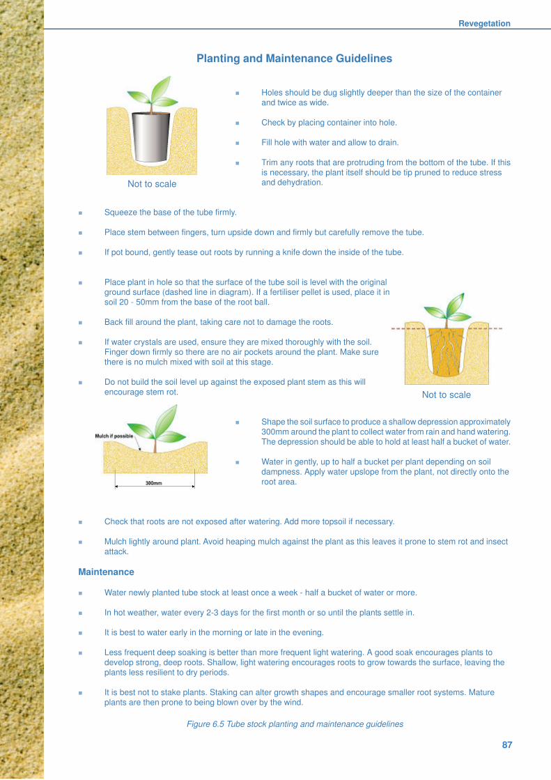
Revegetation
87
Figure 6.5 Tube stock planting and maintenance guidelines
Planting and Maintenance Guidelines
n Holes should be dug slightly deeper than the size of the container
and twice as wide.
n Check by placing container into hole.
n Fill hole with water and allow to drain.
n Trim any roots that are protruding from the bottom of the tube. If this
is necessary, the plant itself should be tip pruned to reduce stressand dehydration.
n Squeeze the base of the tube firmly.
n Place stem between fingers, turn upside down and firmly but carefully remove the tube.
n If pot bound, gently tease out roots by running a knife down the inside of the tube.
n Place plant in hole so that the surface of the tube soil is level with the originalground surface (dashed line in diagram). If a fertiliser pellet is used, place it in
soil 20 - 50mm from the base of the root ball.
n Back fill around the plant, taking care not to damage the roots.
n If water crystals are used, ensure they are mixed thoroughly with the soil.
Finger down firmly so there are no air pockets around the plant. Make sure
there is no mulch mixed with soil at this stage.
n Do not build the soil level up against the exposed plant stem as this will
encourage stem rot.
n Shape the soil surface to produce a shallow depression approximately
300mm around the plant to collect water from rain and hand watering.
The depression should be able to hold at least half a bucket of water.
n Water in gently, up to half a bucket per plant depending on soil
dampness. Apply water upslope from the plant, not directly onto the
root area.
n Check that roots are not exposed after watering. Add more topsoil if necessary.
n Mulch lightly around plant. Avoid heaping mulch against the plant as this leaves it prone to stem rot and insect
attack.
Maintenance
n Water newly planted tube stock at least once a week - half a bucket of water or more.
n In hot weather, water every 2-3 days for the first month or so until the plants settle in.
n It is best to water early in the morning or late in the evening.
n Less frequent deep soaking is better than more frequent light watering. A good soak encourages plants to
develop strong, deep roots. Shallow, light watering encourages roots to grow towards the surface, leaving the
plants less resilient to dry periods.
n It is best not to stake plants. Staking can alter growth shapes and encourage smaller root systems. Mature
plants are then prone to being blown over by the wind.
Not to scale
Not to scale

Coastal Dune Management
88
The importance of Soil Microbes: When planting
tube stock it is beneficial to introduce the correct
soil microbes into the planting soil. Some of the
main microbes that are known to be beneficial are
mycorrhizal fungi and rhizobium bacteria. These
enhance plant growth by enabling the plant to either
absorb water and nutrients more readily or to fix
atmospheric nitrogen into the soil. It has beendemonstrated in many revegetation projects that
plants have an increased survival rate if correct soil
microbes are introduced.
Surface soil and leaf litter endowed with good
microbes can be obtained from healthy vegetated
areas that are close to the project site. It is best to
take the material from the same species intended
for planting. Soil should be removed very carefully
to ensure minimal disturbance of the establishedplants. Only a very small handful of soil is necessary
to introduce enough microbes to be effective. This
can be combined with the mulch and applied
together when planting.
Brush mulching: Another way of assisting
revegetation is by brush mulching. Depending on
availability of suitable plant material, branches of
various sizes, with seed capsules or fruits can be
strewn about. Seeding habits need to beestablished before use. Some fruits stay mostly
unopened on the branch until it dies (eg. Tea Tree).
Others release seed each year - in December-
January in the case of Coastal Banksia, or soon
after flowering, eg. Grevillea sp. Ensure no seed
from exotic or non-indigenous plants is introduced.
Transplanting: Transplanting is also an effective
means of re-establishing vegetation. It is often easy
to source appropriate plants adjacent to the projectarea. Species such as spinifex and pigface are
readily transplanted and are available on the
foredune. Some specific transplanting techniques
are discussed in the following sections. Additional
information is available in the Coastal Plant
Propagation Manual (EnviTE 1998).
6.4.2 Watering management
The sand should be moist when planting but this is
not always possible. A common scenario …. the
plants were ready to plant a couple of months ago,
the working bee is on this Sunday and the weather
has turned dry and windy. Each hole should be
watered with about half a bucket of water before
planting. If the weather remains dry and windy,
water should be applied again within a week if
possible. Dune plants quickly develop very deep
roots, so once they have been in the ground for afew weeks and growing actively they will need no
further watering.
Sometimes when sand has dried out it becomes
hydrophobic - difficult to wet. Water runs across
the surface but will not soak in. A wetting agent
may be added to overcome this problem for a few
weeks. Worth considering are water crystals which
are added to the soil when planting. These should
be mixed thoroughly throughout the soil prior to
planting so that plant roots do not becomedependent on crystals in one small area just below
the plant. There are several brands readily available
from most commercial nurseries. Each brand has
varied application methods so it is important to
follow the product’s instructions. Water crystals are
especially useful if planting during extended dry
periods cannot be avoided. They are also very
useful in more remote locations where the plants
will not be attended to for long periods.
In some dune areas organic mulch may be
available. Dead bitou trash or other weed material
without seeds is suitable. It will help reduce water
loss and erosion and may protect plants from wind.
It also acts as a long-term slow release fertiliser as
it eventually breaks down to release humus into
the soil. At some localities dead seagrass gathered
following authorised rehabilitation work in coastal
lagoons has also been used successfully.
6.4.3 Tree guards
Tree guards may be necessary for the successful
establishment of some species. They are used to
protect plants from grazing animals, wind and frost.
There are numerous brands available on the market
that can be purchased through a local nursery and
other organisations. They generally comprise an
open-ended plastic bag that is staked in threecorners to form a small greenhouse about 300mm
wide. During installation a 25mm cuff can be folded
on to the lower inside of the guard. This can retain
sufficient water to provide a more moist
microclimate within the guard. This type of plant
guard is particularly useful for establishing littoral
rainforest and other hind dune species. For
shoestring budgets other materials such as milk
cartons and cardboard tubing can also be used with
great success.
Tree guards often attract vandals so it is best to
use them in more remote locations or areas where
vandalism is less likely to occur. Some practitioners
recommend that two 1.8m lengths of 4mm wire be
used as stakes - the bamboo stake alternatives
are frequently stolen. Each wire is bent to form a
rectangular hoop 220mm wide across the top, with
both ends inserted approximately 300mm into the
ground. Plastic tree guards should be securedfirmly. They may harm marine life if blown into the
sea.

Revegetation
89
6.4.4 Fertiliser
Established natural vegetation cover on
undisturbed coastal dunes does not require the
application of artificial fertilisers. Dune plants haveadapted naturally to a relatively impoverishedgrowing environment characterised by very slowbuild up of humus due to decay of organic matter.Inorganic fertilisers are harmful to some dune plantseg. those that rely on mycorrhizal fungi to assistnutrient uptake. As a general rule, application offertiliser should be restricted to judicious stimulationof primary sand-binding grasses (Section 6.7.1).
However, where primary, secondary and tertiaryspecies are being planted for the first time, theaddition of fertiliser can assist in their initialestablishment. The addition of fertiliser will also aidin the recovery of partially damaged areas ofexisting dune vegetation.
The amount and type of fertiliser will depend onthe plant species to be fertilised, the nutrient contentof the soil, frequency of application and climaticconditions. Generally, a slow release nativeformulation (low Phosphorous) is preferred. Afertiliser program may need to be developed, asthe composition of vegetation communities can bemanipulated to some extent by the application offertilisers. Fertilising beyond initial planting isunnecessary and is not recommended.
Time of application: This has an important bearingon the effectiveness of the fertiliser. For example,because nitrogen is leached rapidly from the sandmore benefit is gained by applying nitrogen fertiliserto primary grasses twice a year as opposed to aheavy application once a year.
The precise time of application will vary accordingto local rainfall patterns and the experience of theprogram supervisors. Fertiliser applied beforeheavy rain may be leached completely from thesoil before uptake by the plants is possible. This iswhere “local knowledge” plays an important part inthe success of fertiliser programs. For this reasonfrequent applications of fertilisers at a lower ratethan normal may be more successful.
Rate of application: The application of differentfertilisers at different rates can achieve the desiredlevel of nutrients. Before a fertiliser program isworked out, consideration must be given to the unitprice per kilogram of the required element. Somefertilisers may appear to be expensive but ananalysis of their percentage elements will determinethe unit price of that element. Additional specificguidance on fertilising is included in Section 6.7.
Method of application: Most fertilisers aregranular, making application by hand andmechanical methods quite simple.
Hand broadcasting is used most commonly oversmall areas. A worker with a plastic bucket loaded
with fertiliser walks around the planted vegetation
in a predetermined pattern casting the fertiliser out
by hand so that all areas receive the appropriate
amount. It is often helpful to first mark out an area,say 10m by 10m (0.01ha) and spread the requiredfertiliser in this area. Practice soon makes theworker competent at assessing the right applicationrate. Note: use of gloves is recommended.
Machine spreading through a tractor mountedfertiliser spreader can also be quite useful.However, damage to vegetation such as grassesand young shrubs is generally considerable andbecause of this hand broadcasting is preferred.
For large areas aerial application of fertilisersshould be considered. Costs vary a lot and dependstrongly on the proximity of the project area to asuitable airstrip. Both fixed wing aircraft andhelicopters can be used. When applying fertiliserby air, care must be taken to ensure thatrequirements of relevant legislation and regulationsare satisfied.
6.5 Maintenance
As in any rehabilitation project, maintenanceis a crucial aspect in achieving successfulrevegetation. Maintenance is an on-goingelement that will need to be continued forseveral years after the vegetation has beenestablished (Figure 6.1). It is fairly easy to havea very good implementation phase but if it isnot nurtured in the early stages to a point whereit is self-sustaining then the probability ofwasted effort and resources is very high.
Many areas that have been rehabilitated in the pastare now in urgent need of maintenance to removeweeds and to enhance biodiversity.
Some of the main activities that require ongoingfollow-up work include watering, fertilising, weeding,maintenance of infrastructure (walkways, fences)and deterrence of pests such as grazing animals.
Maintenance needs to be factored into allrevegetation projects. Long term goals must be setin the early planning stages to ensure there isenough time and money committed to thiscomponent when the need arises.
6.6 Monitoring
Monitoring is another important aspect to consider.It is strongly recommended that comprehensiverecords of progress be maintained (see 3.4.6). Thismonitoring will then provide the feedback neededto determine maintenance requirements and willhelp to measure the effectiveness of therevegetation.
Record keeping can be done through simple means
such as photography and note taking. It should
include “before” and “after” photographs and should

Coastal Dune Management
90
document plant survival rates, annual plant growth,
watering and fertiliser regimes, vandalism etc. It
can also take on more elaborate scientific
assessments and statistical analysis to gain an
insight into the ecological variations over time.
Most revegetation projects generally use
photographic diaries and notes as this is thecheapest and easiest method to maintain. For more
scientific methods refer to the Greening Australia
website.
6.7 Species commonly used forrevegetation
The majority of plants on coastal dunes are drawn
from a relatively small number of species, especiallyon and seaward of the foredune. However the
relatively rich biodiversity of these environments
also relies on the presence of numerous other
species, even though they may be represented by
only a small number of individual plants. Successful
revegetation projects will strive to reproduce this
diversity as closely as practicable.
Achieving this goal is difficult. Often there is
incomplete knowledge of the original vegetation ata disturbed site, while all sites can suffer from
incomplete knowledge of propagation and growth
characteristics of many of the less common
species. A guide to some of the dune plants and
their characteristics is presented in Figure 6.6. It
combines geographical variation with cross-section
zonation as well as providing summary information
on plant utility. It is emphasised that this table is
selective and that not all the species listed occur
on all beaches. Clarke (1989a), Carolin and Clarke(1991) and the Coastal Plant Database (Fiedler in
preparation) provide more detailed information. The
most recent specialist advice should always be
sought from local practitioners within the
community, local council or state agencies.
Propagation experiments with different species are
encouraged, provided the results are reported
widely for others to use.
6.7.1 Spinifex
Spinifex (Spinifex sericeus) is the most important
sand stabilising plant on the NSW coast. While it
occurs along the entire coast, it is a summer
growing species that is favoured by warm conditions
and hence it performs particularly well along the
coastline north from the Hunter River. However
dense cover can also be established in cooler
areas, as is evidenced by much of the coastline of
the North Island, New Zealand (Bergin 1999).
Planting: Spinifex is best established between
October and March inclusive. It is normally
established by hand planting either entire seed
Seed Heads: Spinifex seed heads mature during
November-December, detach from the parent plant
and are blown about the dune where they gather
in hollows or against other vegetation. Collection
should occur sooner rather than later or birds will
have consumed much of the seed. Seed shouldbe stored in a dark, dry place, preferably in hessian
bags in a vermin-proof area for later planting. Plastic
bags allow seed to rot. A small proportion of seed
is viable for up to six years, but is preferably used
no later than the following season.
Budgewoi Dune Care recommend that one third to
one half of a seed head cluster be sown 600mm
apart, although other workers recommend three orfour seed heads planted together in more widely
spaced holes. Seeds should be buried 30-100mm,
preferably in moist sand.
New Zealand experience suggests that if nursery
facilities are available, raising tube stock from seeds
can provide sufficient plants for large scale projects
(Bergin 1999).
Grown cuttings: Runners are cut into lengthsimmediately below a node, leaving one or two
nodes and the runner tip for eventual exposure
above the sand surface. Budgewoi Dune Care dip
these cuttings in hormone prior to planting in trays
of moist sand. They report root development within
approximately three weeks any month except
during winter. Success rate with this method is quite
good, but it is more time consuming. It is most useful
if seed stock is unavailable.
Runners: In some situations spinifex established
from runners can provide adequate ground cover
within twelve months of planting. This compares
favourably with the 12-24 months generally required
for satisfactory establishment of cover from seed.
Runners or tip cuttings 400-600mm long should be
planted on a 1000mm grid into moist sand at a
depth of 200-300mm. Runners or tip cuttings with
root buds on the nodes are best. Stolon material
with established roots on nodes will not grow andshould not be used.
heads harvested directly from the plant, or runners.
Two other methods of establishment are
transplanting and sprigging, and sowing of threshedseed. Spinifex trials at Budgewoi on the Central
Coast (Budgewoi Dune Care 2000) showed that
planting small clusters of seeds directly into the
dune early in Spring was the most successful
technique (Figure 6.7).
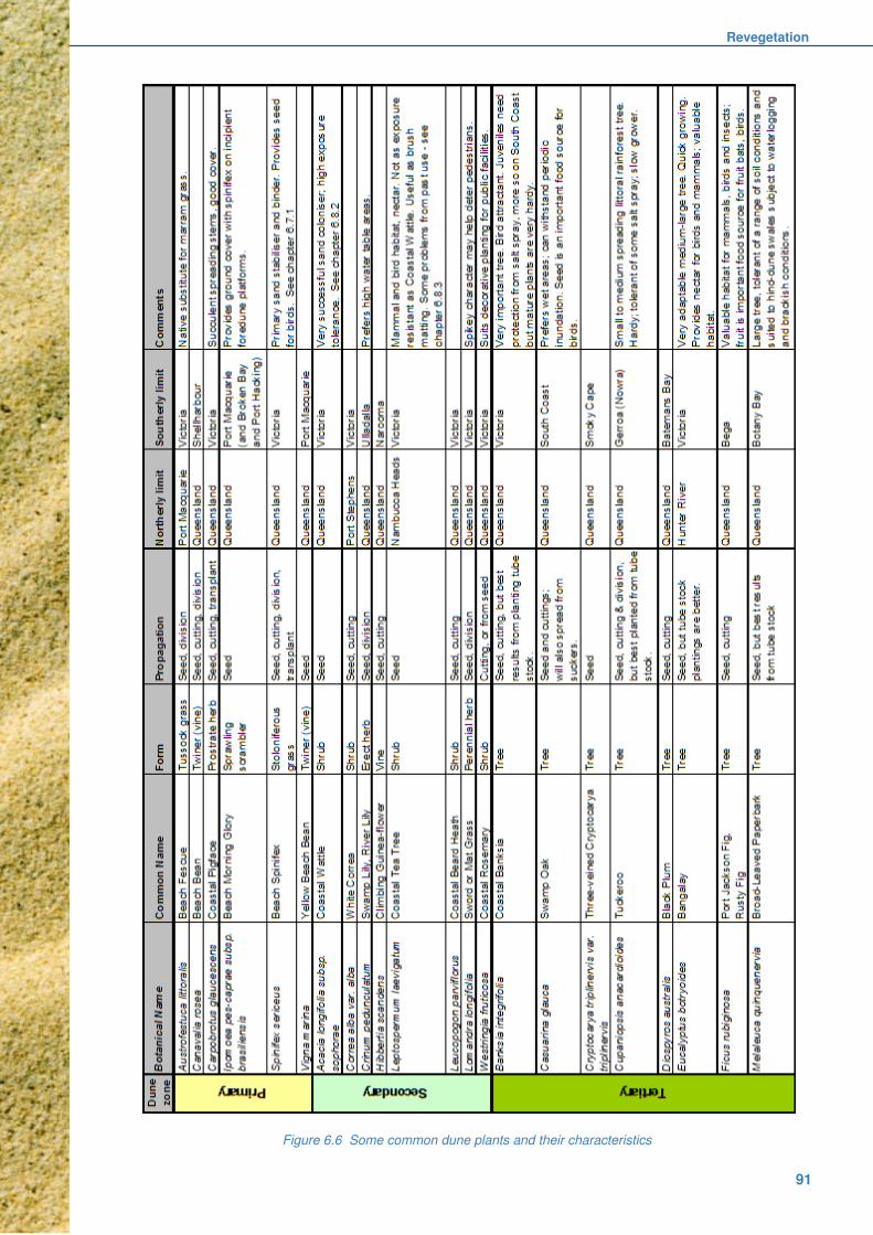
Revegetation
91
Figure 6.6 Some common dune plants and their characteristics

Coastal Dune Management
92
Experience with use of runners suggests that
complete burial of the runner is not desirable.
Rather the runner tip (if it is available) or one or
two nodes of the runner should be left exposed to
provide satisfactory establishment.
Spinifex runners should be planted between April
and September provided soil moisture is adequate.Budgewoi Dune Care found that runners delivered
the poorest success rate in their trials. Temporary
soil surface stabilisation is necessary, for example
with brush matting.
Transplanting: A technique successfully employed
by Port Stephens Council is the complete transplant
of spinifex material and sand. The technique
requires an adequate nursery area maintained by
heavy fertiliser application. This is considered tobe particularly suitable where the nursery area is
located very close to the revegetation site. Here
the planting material is placed in rows spaced 2m
apart and fertilised. Further advice on this technique
may be obtained from the Council.
Another transplanting technique used successfully
by the Queensland Beach Protection Authority is
to establish spinifex from sprigs. Sprigs of grass
which have established from seed or runners andwhich show vigorous leaf and root growth are spade
harvested, separated into 30-50mm diameter sprigs
and planted.
Fertilising: Spinifex responds very well to high
nitrogen fertiliser broadcast 2-3 weeks after planting
and early in both Spring and Autumn to take
advantage of best growing seasons. It can be
applied in Spring to enhance established plants.
Where spinifex is being established from seed inan area that has been temporarily stabilised by
brush matting, fertiliser application should be
deferred until after germination.
Brush matting: Extensive spinifex plantings,
especially using seed, must be accompanied by
brush matting (Section 4.5.1) in exposed sites.
6.8 Some special revegetation issues
Increasing awareness of biodiversity values has
encouraged the development of more sophisticatedrevegetation projects that attempt to re-establish
functional ecosystems. Today, some of the plant
species used in the past are viewed with caution if
not concern. Marram grass, the exotic but very
successful sand-binder for example, has
demonstrated a much longer persistence than was
originally anticipated. Even some natives have
displayed weed-like attributes. With this in mind it
is important to have mixed plantings and not to over-use one favoured species.
6.8.1 Marram Grass(Ammophila arenaria)
This plant is a native of the Mediterranean area
that is found commonly on cooler coastlines of
Europe, North America, South Africa and Australia.
It was introduced to Australia in the 1880s as a
primary sand-binding grass. Its rapid growth inresponse to sand burial made it ideal for stabilising
degraded dunes and it has been used extensively
for this purpose in NSW, especially south of the
Hunter River.
It is very easy to harvest and plant and its tussocky
form allows it to begin trapping sand as soon as it
is planted. New growth usually appears within a
couple of weeks of planting. Although
acknowledged as an exotic, its widespread use inNSW was justified in terms of its excellent sand
stabilising capability and the expectation that it
would die off within a few years and not establish
itself.
Figure 6.7 Succesful Spinifex planting at Budgewoi.

Revegetation
93
Marram planting is now not encouraged. It
persists in the landscape for many years longer
than expected, encouraging development of a more
hummocky dune surface, and there is evidence
from the South Coast that its persistence is
impacting adversely on re-establishment of natural
dune biodiversity (Webb et al. 2000). In Victoria
and Tasmania, longer day lengths have allowed itto produce viable seed and it has spread profusely
at the expense of native primary grasses such as
the Beach Fescue (Austrofestuca littoralis) and
Spinifex. There are reports of it producing non-
viable seed in southern NSW but there is no
evidence of it reproducing there.
Because of these concerns, and noting recent
success in establishing dense spinifex cover
(Section 6.7.1), marram planting can now only beconsidered where severe degradation is affecting
a large area. In these circumstances, co-planting
and follow-up planting of locally indigenous primary
zone species is essential. Removal of persistent
marram tussocks as the native plants establish
themselves may also be required.
More widespread use of Beach Fescue is also
encouraged, especially along the southern half of
the coast. It can be established from seed andlarger clumps can be divided and replanted, but
more detailed assessment of its growth rates and
its response to fertiliser is needed before it can be
considered a viable alternative to marram grass.
6.8.2 Coastal Wattle (Acacia sophorae)
Coastal wattle has been one of the most successful
and widely used secondary species in coastal dunerevegetation programs. The plant is a legume that
“fixes” atmospheric nitrogen and converts it to a
form available to both the wattle and other dune
plants growing in the sand within its root zone.
It is quite tolerant of salt spray and is distributed
right along the coast. However the extent of this
Acacia’s natural geographical range is a matter of
contention. It was widely planted following sand
mining on the North Coast and its very successfulestablishment in such areas may be masking its
natural distribution.
In exposed locations coastal wattle develops a
typically prostrate spreading habit, establishing
roots on the nodes of branches that are in contact
with the soil surface. These characteristics make it
particularly suitable for planting seaward of the
foredune crest.
Coastal wattle can be established from seedlings
or by direct seeding. Unlike many other secondary
and tertiary species, coastal wattle seed is relatively
large, easily harvested and cleaned. Its hard seed
coat and the ability of small seedlings to withstand
salt spray and some sand movement, are survival
mechanisms that allow the species to successfully
establish from seed. This allows coastal wattle to
be established during the primary revegetation
phase.
While the hard seed coat is a survival mechanism,
it is recommended that half the seed receive heat
treatment before sowing in order to break the seed
coat and facilitate field germination. Rapid
germination and establishment of treated seed will
occur if good rain follows sowing, while the reserve
of hard seed provides for extended subsequent
germinations. This is particularly useful if the initial
germination fails to establish due to a lack of
follow-up rains.
The recommended heat treatment is to place the
seed in a sieve and pour boiling water over it.
Complete immersion of the seed in boiled or boiling
water is not recommended, as excessive heating
may kill the embryo. The seed should be sown on
the day of treatment. Heat-treated seed should not
be stored.
Seed can be mixed with equal parts of sand andshould be broadcast at the rate of 3kg of seed/ha.
The seed should comprise a mix of 1.5kg of heat-
treated seed and 1.5kg of untreated sand.
Best establishment from seed is given by sowing
into a well-established primary grass cover.
However if time is limited, seed may be sown
immediately prior to the planting of spinifex provided
there is adequate protection. This allows much of
the seed to be trodden into the sand during grassplanting operations. This may require more closely
spaced grass planting or some brush matting.
Cautionary note: In some areas, particularly on
the North Coast, prolific germination of Acacia
sophorae has followed removal of bitou, resulting
in a dense Acacia monoculture with many plants
of similar age. As Acacia can fix atmospheric
nitrogen, it outgrows many other species that mightotherwise help to form a more diverse and resilient
plant community. Most Acacia plants will die after
8-10 years, leaving large dead areas and
unprotected dunes that are then exposed to erosion
and weed invasion. In these circumstances,
emergent seedlings could be removed and older
plants pruned to prevent a monoculture developing.
Some regard it as a useful nursery plant to help
establish other species and argue that a
monoculture is not necessarily a bad thing.
In South Africa this plant is equivalent to Bitou Bush
in Australia in terms of its undesirability.

Coastal Dune Management
94
6.10 References and further reading
Bergin D. 1999, Spinifex on Coastal Sand Dunes, New
Zealand Forest Research Institute Limited, Rotorua.
Buchanan R. 1989, Bush Regeneration - Recovering
Australian Landscapes, TAFE Student Learning
Publications, Sydney.
Budgewoi Dune Care 2000, Spinifex Trials at
Budgewoi, paper presented at 3rd Biennial NSW Dune
Care Conference, The Lakes SLSC, Budgewoi, NSW,July 2000.
Carolin R. and Clarke P. 1991, Beach Plants of South
Eastern Australia, Sainty and Associates, Sydney.
Clarke P.J. 1989a, Coastal Dune Vegetation of New
South Wales, University of Sydney Coastal Studies
Unit Technical Report No. 89/1 & Soil Conservation
Service of New South Wales Tech. Rep. No. 21.
Coastcare undated, Locally Indigenous Species,Coastcare Factsheet.
EnviTE 1998, Coastal Plant Propagation Manual - A
Guide for Coastcare Groups in Seed Collection and
Plant Propagation Techniques on the North Coast of
NSW, Environmental Training and Employment
(Northern Rivers) Inc. (EnviTE), Lismore.
Fiedler M. in preparation, NSW Coastal Plants
Database, Department of Land and Water
Conservation and Coastcare, Newcastle.
Greening Australia 1995, Local greening plans: a guide
for vegetation and biodiversity management, Greening
Australia Ltd., Canberra.
Mortlock W. 2000, Local seed for revegetation,
Ecological Management & Restoration, Vol. 1, No.2
August pp 93-101.
Ralph M. 1994, Seed Collection of Australian native
plants: for revegetation, tree planting and directseeding, Murray Ralph, Fitzroy.
Webb C.E., Oliver I. and Pik A.J. 2000, Does Coastal
Foredune Stabilisation with Ammophila arenaria
Restore Plant and Arthropod Communities in
Southeastern Australia?, Restoration Ecology, Vol. 8
No. 3, pp 283-288.
Williams S. and Fiedler M. 1998, Attack of the killer
weeds, Department of Land and Water Conservation
and Coastcare, Parramatta.
Internet siteshttp://www.florabank.org.auhttp://www.greeningaustralia.org.au/
6.8.3 Coastal Tea Tree(Leptospermum laevigatum)
This plant is distributed widely along the coastlineof New South Wales where it occurs mainly inclosed communities. Its natural range in NSW isthought to be from Nambucca Heads south toVictoria. It is generally found on more stable beachformations with low relief. It has a moderatetolerance of salt spray but prefers less exposedsites than those favoured by Coastal Wattle.
Coastal Tea Tree has been extensively planted asa regeneration species, especially by mineral sandsmining companies on the North Coast. At some ofthese sites it has formed dense monocultures thatexclude locally indigenous species and is regardedas a weed. For this reason it is recommended thatany proposal to use this plant outside its range begiven very careful consideration. Coastal Tea Treeis best established from seedling stock as directseeding has not been particularly successful.
6.8.4 Horsetail She-oak(Casuarina equisetifolia subsp.incana)
This is a fast growing native tree whose naturalrange extends northward from Laurieton intoQueensland. It has been used extensively in pastdune rehabilitation projects, especially after sandmining. Its natural habitat in New South Wales isrocky headlands, with rare occurrences on dunes.With a few exceptions, the extensive rehabilitationplantings do not accurately reflect the naturalvegetation of those sites.
6.9 Overview
Attempting to re-establish functional ecosystemson coastal dunes is a major challenge but it is anessential element in the broader task of conservingbiodiversity. Selection of plants that match theirgeographical range and their place within the dune-beach zonation has always been a fundamentalconsideration but a more recent and enduringchallenge is to ensure that only locally indigenousspecies are used in revegetation. Some traditionallysuccessful but exotic sand stabilising plants are nolonger recommended and experimental work isneeded to more carefully assess the growth,function and cultivation of native plants such asthe Beach Fescue. Effective rehabilitation of coastaldune ecosystems will increasingly draw upon theresults of such research.
The other enduring challenge will be to maintainthe rehabilitated dunes, protecting their biodiversity,limiting new weed incursions, and at the same timeproviding safe and informed access to the beaches.
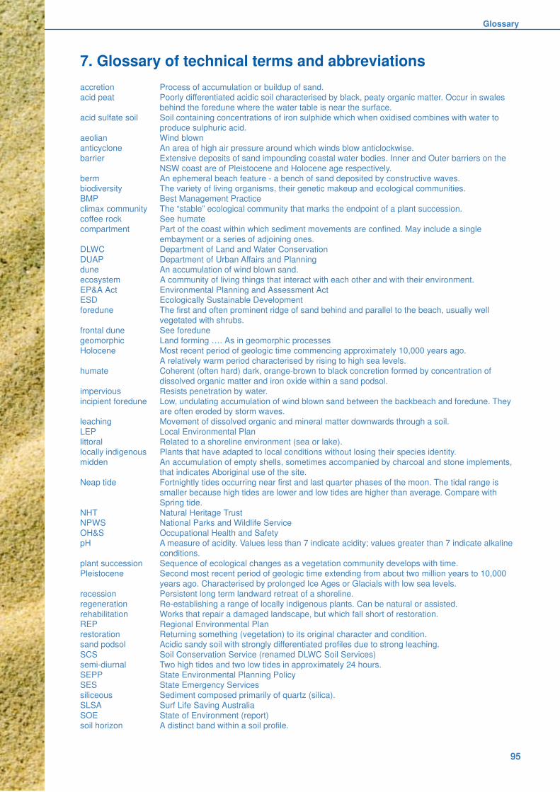
Glossary
95
7. Glossary of technical terms and abbreviations
accretion Process of accumulation or buildup of sand.
acid peat Poorly differentiated acidic soil characterised by black, peaty organic matter. Occur in swales
behind the foredune where the water table is near the surface.
acid sulfate soil Soil containing concentrations of iron sulphide which when oxidised combines with water to
produce sulphuric acid.
aeolian Wind blown
anticyclone An area of high air pressure around which winds blow anticlockwise.
barrier Extensive deposits of sand impounding coastal water bodies. Inner and Outer barriers on the
NSW coast are of Pleistocene and Holocene age respectively.
berm An ephemeral beach feature - a bench of sand deposited by constructive waves.biodiversity The variety of living organisms, their genetic makeup and ecological communities.
BMP Best Management Practice
climax community The “stable” ecological community that marks the endpoint of a plant succession.
coffee rock See humate
compartment Part of the coast within which sediment movements are confined. May include a single
embayment or a series of adjoining ones.
DLWC Department of Land and Water Conservation
DUAP Department of Urban Affairs and Planning
dune An accumulation of wind blown sand.
ecosystem A community of living things that interact with each other and with their environment.
EP&A Act Environmental Planning and Assessment ActESD Ecologically Sustainable Development
foredune The first and often prominent ridge of sand behind and parallel to the beach, usually well
vegetated with shrubs.
frontal dune See foredune
geomorphic Land forming …. As in geomorphic processes
Holocene Most recent period of geologic time commencing approximately 10,000 years ago.
A relatively warm period characterised by rising to high sea levels.
humate Coherent (often hard) dark, orange-brown to black concretion formed by concentration of
dissolved organic matter and iron oxide within a sand podsol.
impervious Resists penetration by water.
incipient foredune Low, undulating accumulation of wind blown sand between the backbeach and foredune. Theyare often eroded by storm waves.
leaching Movement of dissolved organic and mineral matter downwards through a soil.
LEP Local Environmental Plan
littoral Related to a shoreline environment (sea or lake).
locally indigenous Plants that have adapted to local conditions without losing their species identity.
midden An accumulation of empty shells, sometimes accompanied by charcoal and stone implements,
that indicates Aboriginal use of the site.
Neap tide Fortnightly tides occurring near first and last quarter phases of the moon. The tidal range is
smaller because high tides are lower and low tides are higher than average. Compare with
Spring tide.
NHT Natural Heritage TrustNPWS National Parks and Wildlife Service
OH&S Occupational Health and Safety
pH A measure of acidity. Values less than 7 indicate acidity; values greater than 7 indicate alkaline
conditions.
plant succession Sequence of ecological changes as a vegetation community develops with time.
Pleistocene Second most recent period of geologic time extending from about two million years to 10,000
years ago. Characterised by prolonged Ice Ages or Glacials with low sea levels.
recession Persistent long term landward retreat of a shoreline.
regeneration Re-establishing a range of locally indigenous plants. Can be natural or assisted.
rehabilitation Works that repair a damaged landscape, but which fall short of restoration.
REP Regional Environmental Planrestoration Returning something (vegetation) to its original character and condition.
sand podsol Acidic sandy soil with strongly differentiated profiles due to strong leaching.
SCS Soil Conservation Service (renamed DLWC Soil Services)
semi-diurnal Two high tides and two low tides in approximately 24 hours.
SEPP State Environmental Planning Policy
SES State Emergency Services
siliceous Sediment composed primarily of quartz (silica).
SLSA Surf Life Saving Australia
SOE State of Environment (report)
soil horizon A distinct band within a soil profile.

Coastal Dune Management
96
soil profile Vertical differentiation of a soil due to leaching.
Spring tide Fortnightly tides occurring near Full and New Moon. Increased gravitational attraction producesa higher tidal range with high tides higher and low tides lower than average.
stolon Plant stems that rest on the ground surface and develop roots at stem nodes.
swale A low area or depression within a dune field.
swell Longer waves of regular form & spacing that have travelled beyond the area of generation.
wind rose A graphical representation of wind speed, strength and direction.

Notes:

Notes:

Notes:

Notes:

Notes:

Notes:


