63
SAYEDUR RAHMAN CHOWDHURY M SHAHADAT HOSSAIN MD SHAMSUDDOHA S M MUNJURUL HANNAN KHAN COASTAL FISHERS’ LIVELIHOOD IN PERIL: SEA SURFACE TEMPERATURE AND TROPICAL CYCLONES IN BANGLADESH

SAYEDUR RAHMAN CHOWDHURYM SHAHADAT HOSSAINMD SHAMSUDDOHAS M MUNJURUL HANNAN KHAN
COASTAL FISHERS’ LIVELIHOOD IN PERIL:SEA SURFACE TEMPERATURE AND TROPICAL CYCLONESIN BANGLADESH

COASTAL FISHERS’ LIVELIHOOD IN PERIL:SEA SURFACE TEMPERATURE AND TROPICAL CYCLONESIN BANGLADESH
SAYEDUR RAHMAN CHOWDHURYM SHAHADAT HOSSAINMD SHAMSUDDOHAS M MUNJURUL HANNAN KHAN

ii | Coastal Fishers’ Livelihood in Peril
Authors:
Sayedur Rahman Chowdhury is a Professor at the Institute of Marine Sciences and Fisheries of the University of Chittagong, Bangladesh. He is involved in teaching and research in oceanography, coastal geomorphology, and coastal environmental changes.
M Shahadat Hossain is an Associate Professor at the Institute of Marine Sciences and Fisheries of the University of Chittagong, Bangladesh. He is involved in teaching and research in coastal zone management, climate change challenges, fisheries management, community livelihood, and coastal resilience modeling.
Md Shamsuddoha is the Chief Executive of Center for Participatory Research and Development- CPRD, a research based non-government organization in Bangladesh. He is involved in climate change negotiation of the UNFCCC, also involved in the implementation of research projects on climate change and disaster risk reduction in home and abroad.
S M Munjurul Hannan Khan is a Deputy Secretary of the Ministry of Environment and Forests of the Government of Bangladesh. He is involved in climate change negotiation of the UNFCCC as well as AR5 process of IPCC. Also, he is involved with a number of global and national research projects on climate change, biodiversity conservation and environmental management.
Field data collectors:
Data organizer :Subrata Sarker
Citation :Chowdhury,S.R., M.S.Hossain, Md. Shamsuddoha and S.M.M.H.Khan (2012). Coastal Fishers’ Livelihood in Peril: Sea Surface Temperature and Tropical Cyclones in Bangladesh, CPRD, Dhaka, Bangladesh. 54 pp.
Muhammed Forruq RahmanMuhammed Atikul HaqueM. Ziaur RahamanSubrata Sarker
Sraboni ChowdhuryShyamal Chandra BasakMd Royhanur IslamAmirul Haque
Debashish SarkerAhsanul HaqueMd Sakibul IslamKhin Ma U

Coastal Fishers’ Livelihood in Peril | iii
This book has been published as one of the deliverables of the project titled ‘Linking local level climate change vulnerability to the national level policy framework on adaptation’ implemented by the Center of Participatory Research and Development-CPRD with support from Foreign and Commonwealth Office (FCO) of the British High Commission, Dhaka.
Views expressed in this publication are those of the authors and do not necessarily reflect the views of CPRD and the British High Commission, Dhaka.
Publisher :Center for Participatory Research and Development-CPRD, Dhaka, Bangladesh. Published in 2012.
Copyright : © 2012 Center for Participatory Research and Development-CPRD. All rights reserved.
ISBN :978-984-33-5423-5
Cover concept and design:Front: Cyclogenesis locations, Cyclone tracks, and the Eye of the super cyclone Sidr (2007) overlaid on SST Climatology of Bay of Bengal; Back: Fishers going out to sea for fishing near Sonadia Island, Cox’s Bazar (by Sayedur Rahman Chowdhury)
Printers :Helpline Resources, 46/1 Purana Paltan, Dhaka- 1000, Phone : 9571813, 9568579
Available from:Center for Participatory Research and Development-CPRDHouse-138, Flat-A6, Road-3, Block ANiketon Housing, Gulshan-1Dhaka 1212, BangladeshTel: +88-02-9860042Mail: [email protected], [email protected]:www.cprdbd.org

iv | Coastal Fishers’ Livelihood in Peril
Acknowledgement
The publication titled ‘Coastal Fishers’ Livelihood in Peril: Sea Surface Temperature and Tropical Cyclones in Bangladesh’ is a credit to the collaboration between Center for Participatory Research and Development (CPRD) and Institute of Marine Sciences and Fisheries (IMSF) of the University of Chittagong and dedication of its authors, whose proficiency and commitment have enriched the study.
We are grateful to the faculty members of IMSF and colleagues at CPRD for their support and insight in finalizing study methodology. We particularly would like to thank Prof Dr Muhammed Zafar, Prof Dr Md Rashed un Nabi, Prof Dr Ashraful Azam Khan, Dr Sharifuzzaman, Mohammad Muslem Uddin - the faculty members of IMSF for their inputs and suggestions.
We would like to put on record the invaluable coordination and support of Ms Shamaila Mahbub of the British High Commission, Dhaka all through the study and publication of this book.
We would also like to acknowledge the help, information and insights received from the questionnaire respondents during the course of the study. We have learnt much from the respondents of coastal fishing communities, and without their help it would not have been possible to uncover the diverse impacts of increased meteorological hazards on their livelihood.
Finally, we would like to express our sincere thanks to Foreign and Commonwealth Office (FCO) of the British High Commission, Dhaka for its generous support in the implementation of this study.
Coastal Fishers’ Livelihood in Peril | v
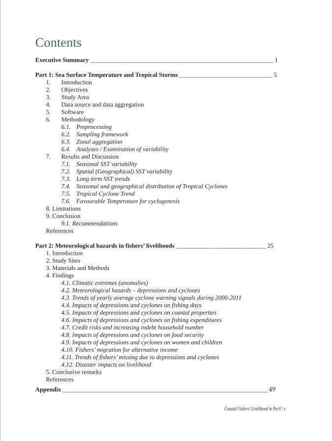
ContentsExecutive Summary ___________________________________________________________ 1
Part 1: Sea Surface Temperature and Tropical Storms ______________________________ 5 1. Introduction 2. Objectives 3. Study Area 4. Data source and data aggregation 5. Software 6. Methodology 6.1. Preprocessing 6.2. Sampling framework 6.3. Zonal aggregation 6.4. Analyses / Examination of variability 7. Results and Discussion 7.1. Seasonal SST variability 7.2. Spatial (Geographical) SST variability 7.3. Long term SST trends 7.4. Seasonal and geographical distribution of Tropical Cyclones 7.5. Tropical Cyclone Trend 7.6. Favourable Temperature for cyclogenesis 8. Limitations 9. Conclusion 9.1. Recommendations References
Part 2: Meteorological hazards in fishers’ livelihoods _____________________________ 25 1. Introduction 2. Study Sites 3. Materials and Methods 4. Findings 4.1. Climatic extremes (anomalies) 4.2. Meteorological hazards – depressions and cyclones 4.3. Trends of yearly average cyclone warning signals during 2000-2011 4.4. Impacts of depressions and cyclones on fishing days 4.5. Impacts of depressions and cyclones on coastal properties 4.6. Impacts of depressions and cyclones on fishing expenditures 4.7. Credit risks and increasing indebt household number 4.8. Impacts of depressions and cyclones on food security 4.9. Impacts of depressions and cyclones on women and children 4.10. Fishers’ migration for alternative income 4.11. Trends of fishers’ missing due to depressions and cyclones 4.12. Disaster impacts on livelihood 5. Conclusive remarks ReferencesAppendix __________________________________________________________________ 49

vi | Coastal Fishers’ Livelihood in Peril
List of Abbreviations
ASCII American Standard Code for Information Interchange
AR5 Assessment Report 5 (IPCC)
AVHRR Advanced Very High Resolution Radiometer
BMD Bangladesh Meteorological Department
CBOs Community Based Organizations
CPP Cyclone Preparedness Program
DSST Daytime SST
DNSST Day-Night combined SST
DNSSTTS Day-Night combined SST Time Series
ENVI Environment for Visualizing Images
ENSO El-Nino Southern Oscillation
GIS Geographical Information System
HH Household Head
IBTrACS International Best Track Archive for Climate Stewarship
NCC National Coordination Committee
NCDC National Climate Data Center
NGOs Non-Governmental Organizations
NOAA National Oceanic and Atmospheric Administration
NODC National Oceanographic Data Center
NSST Nighttime SST
POES Polar Operational Environmental Satellites
RSMAS Rosenstiel School of Marine and Atmospheric
SLA Sustainable Livelihood Approach
SSF Small-Scale Fisheries
SPSS Statistical Package for Social Sciences
SSHA Sea Surface Height Anomaly
SST Sea Surface Temperature
TRMM Tropical Rainfall Monitoring Mission

Executive Summary
Bangladesh is one of the most disaster prone countries of the world and here climatic events are considered an integral part of the social fabric. More than 3.5 million coastal peoples’ livelihood directly or indirectly depend on fishing and related activities under extremely difficult conditions, and their economic hardship is most likely to be aggravated by climate change and its manifestations in various means. This study undertakes to examine the probable linkage of the changing regimes in Sea Surface Temperature, Tropical Cyclones and related climatic hazards with the declining livelihood of the coastal fishers. Chapters of this book are organized into two sections, the first documenting the Sea Surface Temperature and Tropical Cyclones in the Bay of Bengal based on analysis of available climatic data between 1985 and 2009; and the second documents fishers’ own experience and perceptions of the changing climate based on analysis of survey data from ten coastal areas of Bangladesh.
1. Sea Surface Temperature
Monthly Daytime and Night time Sea Surface Temperature (SST) over the Bay of Bengal from 1985 to 2009 have been analysed to find out (a) seasonal variations, (b) geographical distribution, and (c) long term trend (i.e. rise or fall) of temperature. While the first two kinds of variations are mainly linked to local weather and climate, and annual climatic cycles associated with monsoons; the third is expected to be coupled with global and regional Climate Change including Global Warming. Observed long-term often non-cyclic and irreversible climatic variabilities are linked to changing patterns of precipitation and drought, intensification of tropical cyclones and climatic disturbances, which are anticipated to be bringing about permanent change in fishing effort and livelihood of the fishing communities all along Bangladesh coast. This part of the technical chapter aims at identifying important components of temperature variability over the Bay of Bengal.
Seasonal variability:
SST over the Bay of Bengal has distinct bimodal seasonal cycles with two warm and two cool seasons in a year, one cycle being more prominent than the other. During the Winter (January) SST remains low and reaches it maximum during the Summer (April-May) followed by a secondary low in Monsoon (July-August) and secondary high in around October before it starts to cool down again. There are, however, differences in the pattern at different. Seasonal range of monthly mean temperature is relatively small at southern Bay of Bengal and large at the northern Bay.
Coastal Fishers’ Livelihood in Peril | 1

Geographical variability:
Northern Bay of Bengal close to Bangladesh coast is generally cooler than the southern Bay of Bengal, particularly in winter. Strong zonal temperature gradient develops in the cooler months during the Northeast monsoon. Such strong zonal gradient becomes apparent from November to March. Zonal temperature gradient weakens or disappears during the summer and wet months.
Long Term variability:
SST is found to increase everywhere in the Bay of Bengal. Night time SST is found to increase at a much faster rate than the Daytime SST. Night SST is considered more reliable indicator of temperature than daytime SST. It has increased by 0.30-0.48°C since 1985 at rates between 0.0126° and 0.0203° per year. Daytime SST also shows increase trends everywhere, ranging from 0.20° to 0.46°C during the period, annual rates ranging from 0.0086° to 0.0191°.
Like the seasonal variations, long term trend also exhibits zonal variations. Both Day and Night SST are increasing faster in the mid latitudes of the bay. This zone is generally not the breeding ground of Bay of Bengal cyclones, but most cyclones have to travel through this area before making landfalls.
If the trends found in this study are the true long term trends and the temperature increase continues in the future at similar rates we would expect a rise of Night time SST in the Bay of Bengal from 0.5° to 0.8°C and daytime SST from 0.35° to 0.72°C by 2050.
2. Tropical Cyclones
Tropical storms in the Bay of Bengal including cyclones and depressions during the period 1985-2009 have been studies to understand their frequency, seasonal and geographical distribution of origin, landfall distribution and long term trend. April-May and October-November are the two main seasons producing storms of cyclonic strength. Those cyclones generally originate in the southern Bay of Bengal and the Andaman Sea, and most of them make landfalls in Bangladesh and Myanmar. During the southwest monsoon depressions and storms form at the northern bay, but they typically falls at the Orissa coast of India.
Cyclone frequency is found to be increasing during the study period. During this period Bay of Bengal has produced on average 5.48 storms per year or once every 9.49 weeks. With an increasing rate above, we may experience a frequency of 7.94 storms per year or once every 6.54 weeks by 2050.
Favourable SST for cyclone formation is also studied. Results indicate that increasing SST in cooler months and in cooler regions at the bay can be interpreted as widening cyclone season, and larger cyclone breeding grounds.
Practical consequences of the warming sea:
Tropical cyclones or the so called ‘atmospheric heat engines’ gather heat energy from the warm sea water and reinforce their momentum by gaining more heat and moisture as they travel through warm areas of the sea. Therefore, we experience two cyclone seasons in Bangladesh – one in
2 | Coastal Fishers’ Livelihood in Peril

April-May and the other in October-November, when the sea surface temperature remains relatively high. The cyclone seasons in the Bay of Bengal are likely to widen further as the cooler months become warmer. Moreover, as the usually cooler high latitude zones get warmer, cyclones will get larger replenishment area for gaining heat energy, thus increasing the risk of cyclones at the coast.
The rapidly warming middle Bay of Bengal can appear to be a source of danger as storms traveling across this zone will have access to more heat energy and moisture to remain strong, or to become even stronger. This zone can even become a potential breeding ground for cyclones and depressions.
However less obvious it might be, more difficult weather conditions for small scale fishers arise from the so called ‘rough seas’ characterised by windy condition and wavy sea surface, or ‘high seas’. Much of the wind and as a result waves are direct consequences of atmospheric convection cells of varying magnitudes which in turn are driven by temperature difference between two places at sea, or between the sea and the land. Changing regime of temperature at sea is likely to bring about changes in the local weather and wind-wave system which may pose additional hazard for artisanal fishers; nevertheless, the nature of change cannot be predicted without modelling those processes.
3. Meteorological hazards in fishers’ livelihoods
Primary data were collected through the survey of 500 fishers’ household from 10 coastal locations. The questionnaire addresses family data, crafts and gears with fishing durations, catch rates, market prices, trends of climatic changes with effects on fisheries and fishers’ livelihood. Data analysis reveals that increased windstorm, wave height and current velocity are the major climatic hazards in the Bay of Bengal in recent years.
Most of the fishers agree on the increase of recent meteorological hazards i.e. depressions and cyclones in the fishing zone of the Bay of Bengal that increases fishing expenditures. Coastal fishers enhances their religious activities when they realize a cyclone is imminent with danger signals and adopt wait- and-see approach before leaving their homes for a cyclone shelter. Tropical cyclones and tidal surges damage houses, boats, fish landing jetties, roads and other physical assets that make the fishers workless. Fishing is the only livelihood option for coastal fishers; economic diversification with other income generating activities does not mean anything to them. The big question is how the fishers can sustain in warmer water with lot of disasters and without fishing initiatives.
Coastal Fishers’ Livelihood in Peril | 3


1. IntroductionHeat condition of the Ocean in the form of Sea Surface Temperature (SST) is one of the most
important variables used in Climate Change monitoring programs and is often related to other variables such as sea level change, hurricane intensity, etc. (Vinogradova 2009). Despite being very important in global and regional climate, Indian Ocean is the least studied Ocean of all and the Bay of Bengal is even less understood. Being a maritime state Bangladesh and its climate is dominated by the Indian Ocean monsoon and maritime climate over the Bay of Bengal. Atmospheric depressions and cyclones, moisture and cloud from the ocean, and heat exchange between ocean and the atmosphere have profound impacts on almost every aspects of Bangladesh – from agriculture to health, transportation to economy, literature to peoples’ livelihood to name a few horizons.
Tropical cyclones have a particularly important role in the country’s economy and lives. Bay of Bengal is a potentially energetic region for the development of cyclonic storms; about 7% of the global cyclonic storms are formed in this region (Gray 1968). Though many external and internal factors (e.g., low-level relative vorticity, vertical wind shear, SST, mixed level depth, tropospheric stability, mid-tropospheric humidity) are considered favourable for cyclonic storms (McPhaden et al. 2009a), in particular for those forming in the Bay of Bengal (Yokoi and Takayabu 2010; Yu and McPhaden 2011), SST is considered one of the major drivers of cyclogenesis (Krishna and Rao 2010) or of storm intensification (DeMaria and Kaplan 1994; Whitney and Hobgood 1997). SST is discussed in the context of global warming related enhancement of cyclonic activity (Webster et al. 2005; Michaels et al. 2006; Emanuel 2007; Elsner et al. 2008) and their destructive power (Emanuel 2005) however difficult, uncertain, and conflicting the results might be (Walsh 2004; Landsea et al. 2006; Knutson et al. 2010). Higher SST results in increased water vapour in the lower tropospeher and thus fuels the convection (Krishna and Rao 2010). It is anticipated that in the process of global warming cyclone activities may further intensify (Krishna 2009), thereby causing havoc to coastal communities. Three elements associated with a cyclone are identified to cause destruction, namely, (1) heavy and prolonged rain, (2) storm surge, and (3) very strong winds (Kotal et al. 2008). Under the continued increase in green house gas emissions and global warming studying and understanding SST and its trend are therefore critical for disaster preparedness and hazard evasion.
1 CH
APT
ERSea Surface Temperature (SST)and Tropical Cyclones
Coastal Fishers’ Livelihood in Peril | 5

2. Objectives
The central objective of this study is to examine the long term variability of Sea Surface Temperature (SST) over the Bay of Bengal using satellite based SST record as a vital indicator of changing climate in the maritime regime. It is anticipated that with changing climate and warming sea, coastal waters are increasingly becoming or are likely to become ‘hostile’ for small country fishing boats used by the artisanal fishing communities. Distribution and frequency of tropical cyclones including depressions are also intended to be studied to understand how coastal fishers’ communities are likely to be affected by changes in the climate resulting in the so called ‘rough seas’. Among other objectives is to examine the geographical and seasonal variations of temperature.
3. Study Area
For studying the distribution and temporal variations of SST in the Bay of Bengal the area bounded between 6° and 22° North latitudes, and between 80° and 95° East longitudes was selected (Figure 1). Only the Bay of Bengal basin area is taken for observations and the Andaman Sea is excluded. The bay is effectively divided into 16 one-degree latitude zones for further analysis. For studying tropical storms the Andaman Sea in included as part of the Bay of Bengal because cyclones generated in both of these basins create equally hazardous situations for coastal areas in surrounding states.
4. Data source and data aggregation
Radiometric measurements by the Advanced Very High Resolution Radiometer (AVHRR) sensor onboard Polar Operational Environmental Satellites (POES) namely, NOAA-7, 9, 11, 14, 16, 17 and 18 of the National Oceanic and Atmospheric Administration (NOAA), USA were used to create SST fields using Pathfinder algorithm developed by University of Miami's Rosenstiel School of Marine and Atmospheric Science (RSMAS) and the NOAA National Oceanographic Data Center (NODC). Details of this dataset can be found in Kilpatrick et al. 2001. These SST products are called Pathfinder SST. The latest major version Pathfinder 5 is a reanalysis of the AVHRR data fields, and is distributed in global oceanic coverages at continuous 4x4 km2 cells. Daily, 8-day, monthly, and annual average fields are distributed for the period 1985-2009. For this study Daytime and Night time Monthly average fields for 300 consecutive months (25 years) from January, 1985 to December, 2009 were acquired from NOAA’s data repository (ftp://ftp.nodc.noaa.gov). It has been demonstrated that at least 17 years of temperature data is required for identifying slowly evolving warming signals in lower atmospheric temperature record (Santer et al. 2011). It is assumed that similar time scale would also be adequate to identify signal in sea surface temperature which is more consistent in its variations than its atmospheric counterpart.
In addition to Pathfinder data, HadiSST from UK’s Met Office Hadley Centre for Climate Prediction and Research was also acquired for the Bay of Bengal on a space averaged monthly mean basis for a longer period (1870-2011). This data is used to examine long term trends in SST. HadISST compares well with other published analyses, capturing trends in global, hemispheric, and regional SST (Rayner et al. 2003).
6 | Coastal Fishers’ Livelihood in Peril

Figure 1. Map showing the study area of the Bay of Bengal, and 263 randomly selected sampling points; bars on the right and bottom axes show the relative distribution of points in each degree interval in Latitude and Longitude respectively; the star at the centre shows the geographic centre of the points distribution, and the light coloured ellipse is the area within 1 standard deviation from the centre. Also shown is a 1 degree grid over the study area
Several tiers of data aggregation were carried out to produce various derivative datasets for subsequent analyses. First, Daytime and Night time SST (DSST and NSST) were averaged to create Day-Night combined SST (DNSST) for 300 months during the period. Locations were discarded where data was missing in either DSST or NSST dataset resulting in missing value in DNSST.
DNSSTym=(DSSTym+NSSTym)/2; where y=1985…2009, m=Jan…Dec
Second, SST climatology datasets were created separately for Day, Night and Day-night combined (DSSTClim, NSSTClim and DNSSTClim). For each month, daytime climatology (DSSTClim) was created by averaging 25 DSST of that month from the 25 year period. The procedure was similarly carried out for NSST and DNSST for 12 months, such that-
DSSTClimm = Sum(DSSTm)/Count of valid data (max=25),
NSSTClimm = Sum(NSSTm)/Count of valid data (max=25), and
DNSSTClimm = Sum(DNSSTm)/Count of valid data (max=25)
Coastal Fishers’ Livelihood in Peril | 7

Third, corresponding climatology dataset was deducted from each DSST, NSST and DNSST field to produce monthly daytime, night time, and combined SST anomaly (deviations from seasonal normal) fields, such that-
DSSTAnomym = DSSTym – DSSTClimm
NSSTAnomym = NSSTym - NSSTClimm
DNSSTAnomym = DNSSTym - DNSSTClimm
Finally, daytime, night time and day-night combined SST time series (DSSTTS, NSSTTS, DNSSTTS) were created by combining all DSST, NSST, and DNSST datasets such that each time series dataset contains 300 months’ monthly mean temperature record in sequence. Similarly, daytime, night time and day-night combined SST Anomaly time series (DSSTAnomTS, NSSTAnomTS, DNSSTAnomTS) were created by combining all DSSTAnom, NSSTAnom, and DNSSTAnom datasets such that each time series dataset contains 300 months’ monthly mean temperature anomaly (deviations from normal) record in sequence.
North Indian Ocean Tropical Cyclone data (1877-2010) was retrieved from International Best Track Archive for Climate Stewardship (IBTrACS) of the National Climatic Data Center (NCDC), NOAA which stores the best estimates of storm position and intensity at 6-hourly intervals on a global scale, known as ‘best-track data’ (Knapp et al. 2010). The data is available in the form of track points for each recorded cyclone.
5. Software
Different software is used for preparing, pre-processing, analysing and presenting data and analytical results. Several small computer programs are written in Matlab to batch process the acquired SST datasets for subsequent image processing in ENVI, and GIS analyses in ArcGIS. Statistical analyses are done in S-Plus. Microsoft Excel is used for various data aggregation and conversions.
6. Methodology
6.1 Preprocessing:
Bay of Bengal subsets from the Global oceanic SST coverages which were created for all datasets and data aggregations as described in para 5, were carried out in Matlab environment using scripts written for this purpose. Resulting datasets were saved on disk as band sequential binary/raw files of floating point numbers and geographic reference information were written in separate header files.
Indian Ocean tropical cyclone track points in ASCII file format was converted into GIS data layer using Latitude and Longitude values in the record. Track lines GIS data layer is created from the track points layer. Cyclons’ initiation locations are extracted from the points layer using the time record to create a Cyclogenesis data layer. A Bay of Bengal subset is created from the Cyclogenesis layer and is filtered further to include only the cyclones that occurred during the study period (1985-2009). Track points and track lines are filtered to include only those records which correspond to the filtered Cyclogenesis points.
8 | Coastal Fishers’ Livelihood in Peril

6.2 Sampling framework:
Acquired SST products and their processed derivatives are raster data and are very useful for visual representations in the form of surfaces and maps. However, it becomes necessary to extract data at discrete point locations for statistical analyses. Extracting data at each cell location (every 4x4 km2) for Day and Night for 300 months would result in very large tabular datasets perhaps without additional statistical advantage, and would be cumbersome to manage in most statistical software. Therefore, 263 random point locations within the stipulated study area are selected for statistical analysis and plotting. These sampling locations were generated by ArcGIS using random latitude and longitude values. Spatial distribution characteristics of the sampling points are examined and are summarized in table 1, and shown in figure 1.
SST and SST anomalies for 300 months were gathered from the datasets at 263 point locations, subsequently plotted and analysed for detection of seasonality and trend. SST climatology values were also gathered for these sampling points for analysis of zonal seasonal patterns.
Table 1. Average Nearest Neighbour Summary of the sampling points
6.3 Zonal aggregation:
SST, SST anomaly and SST Climatology data was further aggregated based on the latitude of the sampling point locations. Summary and aggregate statistics were thus generated for 16 one-degree latitude zones of the Bay of Bengal.
6.4 Analyses/Examination of variability:
Seasonality in SST was examined using seasonal plots and associated values. Geographical variability was examined using color maps, isotherms (figure 2) and data plots (figure 3). Long term trend was examined using trend-line plots (figure 5) and Ordinary Least Square linear regression co-efficients (table 3).
Cyclogenesis points and cyclone track lines are plotted monthwise on maps and associated data is analyzed to examine the geographical and seasonal distribution of tropical cyclones. Annual cyclone frequencies are plotted and modelled as a simple linear regression line as described by Rydén 2011 to determine the long term trend in frequency, if any.
Number of points (N) :Observed Mean Distance :Expected Mean Distance :Nearest Neighbour Ratio :Z Score :p-value :Description of spatial distribution :
2630.484372 degree0.449936 degree1.076535 degree2.3744930.017573 (Sig. at 95%)Slightly Scattered, nearly random
Coastal Fishers’ Livelihood in Peril | 9

Average SST during the month of the formation of each cyclone is extracted from the day-night combined SST time series data using the month and location of corresponding cyclogenesis location. Henceforth, this temperature is described as the ‘favourable temperature’ for cyclongenesis.
Figure 2. Day-Night Combined SST Climatology (DNSSTClim) over Bay of Bengal in different months during 1985-2009, characterised by (a) well defined SST gradient in winter months (NorthEast monsoon?) (Nov-Mar); (b) gradient weakens or disappears in monsoon months
7. Results and Discussion
7.1 Seasonal SST variability:
Monthly mean SST climatology averaged over the period 1985-2009 shows strong seasonal fluctuations in SST, particularly in the northern Bay of Bengal. Strong temperature gradient develops over the Bay during the cooler months from November to March and the gradient weakens or disappears during the southwest monsoon (figure 2).
Various physical factors including oceanic circulation, wind, river discharge (Sengupta and Ravichandran 2001), nearshore upwelling or absence thereof, precipitation-evaporation, El Nino-Southern Oscillation (Nagura and Konda 2007), Indian Ocean Dipole phenomenon (Rao et al. 2002) govern the distribution of temperature over the bay. For example, during the southwest monsoon, forcing by inflow from BoB rivers increases SST by 0.5°-1°C along the northeast coast of India. This is because coastal Kelvin waves driven by the Ganges-Brahmaputra River inflow suppress coastal upwelling along that coast (Han et al. 2001).
10 | Coastal Fishers’ Livelihood in Peril

SST over the Bay of Bengal has distinct bimodal seasonal cycles with two warm and two cool seasons in a year, one cycle being more prominent than the other (figure 3 & 4). Other authors (Lakshmi et al. 2009; Murty et al. 1998) reported similar seasonal cycles. During the Winter (January) SST remains low and reaches it maximum during the Summer (April-May) followed by a secondary low in Monsoon (July-August) and secondary high in around October before it starts to cool down again. There are, however, differences in this pattern at different latitudes (North to South) as regards (a) the size (amplitude) of the total annual variation, and (b) the timing of the peaks and lows.
Seasonal range of monthly mean temperature is small at southern latitudes (about 2°C at 6-7°N) and gradually increases towards the North attaining a large range of about 6°C at 21-22°N (figure 4). Also noticeable is the fact that higher latitude zones (near the coast) attain their peak temperature in Summer about a month or more later than the lower latitudes (i.e., lagging behind); but warms up about a month or so before high latitude zones in Autumn.
A summary of seasonal SST fluctuations over the study period in BoB is shown in table 2.
Coastal Fishers’ Livelihood in Peril | 11
20
22
24
26
28
30
32
Jan Feb Mar Apr May Jun Jul Aug Sep Oct Nov DecMonths
SST
(°C
)
Mean
Max.
Min.
Mean+1σ
Mean-1σ
LEGEND
Figure 3.
SST Climatology (DNSSTClim) distribution in different months in the
Bay of Bengal based on all available 4 km x 4 km
cells (outliers removed)
Figure 4.
Seasonal cycle of SST (DNSSTClim) in different Latitude zones over the
Bay of Bengal, characterized by (1) nearly semi-annual cycles, (2) higher
variation in high latitudes (≈6°C at 21-22°N) to lower variation in low
latitudes (≈2°C at 6-7°N); (3) peaking lags in spring/summer at
higher latitudes and in autumn at low latitudes 22
23
24
25
26
27
28
29
30
31
Jan Feb Mar Apr May Jun Jul Aug Sep Oct Nov Dec
HigherLatitudes
LowerLatitudes
Months
SST
(°C
)
6-7
9-10
20-21
19-20
18-1917-1816-17
12-1314-15
21-22

7.2 Spatial (Geographical) SST variability
Northern Bay of Bengal close to Bangladesh coast is generally cooler than the southern Bay of Bengal, particularly in winter. Strong zonal temperature gradient develops in the cooler months during the Northeast monsoon (figure 2 & 4). Such strong zonal gradient becomes apparent from November to March (23-24°C at 21-22°N; >28°C at 6-7°N). Zonal temperature gradient weakens or disappears during the summer and wet months of southwest monsoon.
7.3 Long term SST trends
Variabilites of varying time scales from several years to decades are generally found in sea surface temperature records; these are called long term oscillations. El-Nino Southern Oscillation (ENSO) in the Pacific or similar events are often attributed to such inter-annual/decadal variations in temperature. However, this technical study examines the 25 year SST record for identifying a liner trend during this period.
Sea surface temperature is found to increase across the board in all 16 one-degree latitudes zones over the Bay of Bengal studied (table 3). Day time and Night time SST are separately examined for trends (figure 5). Night time SST is found to increase at a much faster rate than the Daytime SST (figure 6). Night SST is for several reasons considered more reliable indicator of temperature than daytime SST. It has increased by 0.30-0.48° Celsius since 1985 at rates between 0.0126° and 0.0203° per year. Daytime SST is also found to have registered increase everywhere, ranging from 0.20° to 0.46° Celsius during the period, annual rates ranging from 0.0086 to 0.0191°.
Like the seasonal variations, long term trend also exhibits zonal variations (figure 6). Both Day and Night SST are increasing faster in a zone between 15°N and 19°N latitudes. This zone is generally not the breeding ground for the deadliest cyclones in Bangadesh’s history, but in recent years at least one deadly cyclone, Aila in 2008, was formed here. Further warming in this zone may translate into storms of similar strengths more often than was in the past.
12 | Coastal Fishers’ Livelihood in Peril
MonthJanFebMarAprMayJunJulAugSepOctNovDec
Minimum21.8222.8724.5126.6725.7621.9225.0722.7624.9326.4926.6223.73
Maximum28.7929.0429.7031.1030.9230.9230.8329.9630.0330.3329.5829.02
Mean26.9327.2728.4329.6829.7229.1328.4928.2528.6929.1228.6127.57
Median27.0927.4128.5429.9429.7429.1428.4828.2228.6829.2028.7127.74
St.Dev.1.030.970.760.600.280.360.350.350.400.370.330.78
Table 2. Basic statistics of the day-night combined SST climatology over the Bay of Bengal in different months during 1985-2009 (after outlier removal)

Any changes in the seasonal patterns have also been investigated by analysing SST trends in individual months. Results indicate that at the low and mid-latitude zones early summer temperature is dropping while the late summer temperature is rising quickly. In other months and at other latitude zones SST is consistently rising at a rate of about 0.02°C per year (table 4; figure 7). Present investigation cannot, however, ascertain the cause and effect relationship behind such exceptional rates of change in SST in only a couple of months. Nevertheless, the implications of these exceptional can prove to be very significant as regards shifting or widening of cyclone seasons.
Latitude Zones (°N)21-2220-2119-2018-1917-1816-1715-1614-1513-1412-1311-1210-1109-1008-0907-0806-07
Day0.01670.01300.01690.01640.01910.01500.01330.01200.01010.00860.01080.01100.01150.01380.01380.0167
Night0.01760.01770.01820.02030.01800.01950.01820.01530.01440.01420.01430.01640.01260.01400.01350.0158
Day-Night Combined†0.01480.01630.01830.01870.01920.01700.01580.01400.01230.01170.01360.01430.01300.01510.01530.0185
Table 3. Trend of SST (anomalies) in degree Celsius per year in different latitudes of the Bay of Bengal during 1985-2009 (all positive values signify rising trends everywhere, and all models statistically significant at >99%)
† Day-Night Combined rate is not the arithmetic average of the Day and Night time rates; it is independently estimated from the Day-Night Combined dataset. Due to missing data in Day and Night datasets in mutually exclusive locations, the resulting aggregated combined time series itself is not a simple average of Day and Night time series.
High Anomalies Smooth line Trend line
Low Anomalies Smooth line Trend line
-2.00
-1.50
-1.00
-0.50
0.00
0.50
1.00
1.50
2.00
1985
1986
1987
1988
1989
1990
1991
1992
1993
1994
1995
1996
1997
1998
1999
2000
2001
2002
2003
2004
2005
2006
2007
2008
2009
Day
SST
anom
alie
s
Years
High Anomalies Smooth line Trend line
Low Anomalies Smooth line Trend line
-2.00
-1.50
-1.00
-0.50
0.00
0.50
1.00
1.50
2.00
1985
1986
1987
1988
1989
1990
1991
1992
1993
1994
1995
1996
1997
1998
1999
2000
2001
2002
2003
2004
2005
2006
2007
2008
2009
Nig
htSS
Tan
omal
ies
Years
Figure 5. Monthly mean Daytime SST anomalies (left) and Night time SST anomalies (right) from January, 1985 to December, 2009 in high and low latitudes of the Bay of Bengal; 12-months running mean smooth-lines and OLS linear trend-lines show increasing trends
Coastal Fishers’ Livelihood in Peril | 13

0.006
0.008
0.010
0.012
0.014
0.016
0.018
0.020
0.022
0.024S
ST
An
om
alie
sT
ren
d (
°C p
er
Ye
ar)
Latitude22 21 20 19 18 17 16 15 14 13 12 11 10 09 08 07 06°N
Mean + 1 s.d.
Mean - 1 s.d.
Mean Rate
Day Night CombinedFigure 6.
Trends of Daytime, Night time, and Day-Night Combined SST Anomalies during 1985-2009 at 1 degree intervals of Latitude from 6-22°N (inconsistent occurrence of missing values in source datasets prevent the Combined trends from being the arithmetic averages of Day and Night Trends) (2) Night Temperature increasing faster in most of the Bay Bengal except at low latitudes
MonthJanFebMarAprMayJunJulAugSepOctNovDec
High0.01400.01770.01670.01850.02710.01100.01600.01160.01000.02060.02600.0224
Mid0.01970.02560.01720.0097-0.01680.01670.01230.02450.00890.01390.02080.0293
Low0.01630.01960.01950.0003-0.02570.01560.01460.03600.02220.01420.01570.0260
Table 4. Trend of SST (anomalies) in degree Celsius per year in different months during 1985-2009
Figure 7.
Trend of Night time Monthly SST Anomalies during 1985-2009 at
different latitude zones (May SST falling while August SST rising fast at
mid and low latitudes, while other monthly SSTs are rising at rates
between 0.005 and 0.027 degrees per year)
-0.03
-0.02
-0.01
0.00
0.01
0.02
0.03
0.04
Jan Feb Mar Apr May Jun Jul Aug Sep Oct Nov Dec
HIGH MID LOW
Mean Rate
Mean + 1 s.d.
Mean - 1 s.d.
SST
Ano
mal
ies
Tren
d (°
C p
er y
ear)
Months 14 | Coastal Fishers’ Livelihood in Peril

It is difficult to tell whether the trends found in this study are the true long term trends and not due to inter-decadal oscillations. It is even more difficult to tell whether the rate of increase will remain the same, cycle through decades, decelerate or accelerate. Any forecast of future climatic conditions require complex modeling taking into account all possible climatic variables and processes, and is therefore left outside the scope of this study. However, if the trends found in this study are the true long term trends and the temperature increase continues in the future at similar rates we would expect a rise of Night time SST in the Bay of Bengal from 0.5° to 0.8 ° Celsius and daytime SST from 0.35° to 0.72° Celsius by 2050.
Long term (1870-2011) space averaged SST data over Bay of Bengal (6°-22°N and 80°-95°E) was also examined (table 5; figure 8). Statistically significant rising trends are found in all months’ SST over this period at rates ranging from 0.00302 to 0.00481°C per year with the 12 month average of 0.00401°C. Rates found for 1985-2009 therefore indicate 4-5 fold faster increase in temperature in recent years.
Though Belkin (2009) categorized the Bay of Bengal as one of the rapidly warming Large Marine ecosystems with temperature increasing at 0.04°C/year, the current rates in this study seem to be about half that rate. Source of such large disagreement cannot be, however, ascertained; it may be arising from differences in source datasets, model building, and/or geographic and time scale. Hurrel et al. (1999) documented the inherent problems in several SST datasets; and measured differences among different datasets where they found disagreements in several aspects of the time series data. However, since then many of the datasets have undergone substantial improvements in reanalysis and algorithms (Kilpatrick et al. 2001; Rayner et al. 2003), and one can only expect better estimates in recent years.
Interpretation of trends based on short periods like the current time series may sometimes be mislead by the presence of Long Term Persistence in the data which requires much longer time series and specific analytical treatments thereof. Moreover, even when trends are found statistically significant they may or may not bear real-term significance unless the findings are reconciled against the physical system in question. Cohn and Lins (2005) put that in context as follows:
Figure 8.
Long term monthly (grey) and annual mean (red) SST based on
HadISST data (1870-2011), overall mean (horizontal straight line) and
long term trend (sloping straight line) also shown
25.5
26.0
26.5
27.0
27.5
28.0
28.5
29.0
29.5
30.0
30.5
1870
1880
1890
1900
1910
1920
1930
1940
1950
1960
1970
1980
1990
2000
2010
Mon
thly
Mea
n SS
T (°
C)
Years
Dec
-Feb
Apr-J
unJu
l-Oct
Mar
,Nov
Jan30.2
Feb29.6
Mar30.4
Apr35.9
May36.8
Jun42.0
Jul45.6
Aug47.6
Sep47.6
Oct48.1
Nov45.3
Dec42.7
Mean40.1
Table 5. Long term (1870-2011) monthly and annual HadISST Trend (x104) over Bay of Bengal
Coastal Fishers’ Livelihood in Peril | 15

“Hydroclimatological time series often exhibit trends. While trend magnitude can be determined with little ambiguity, the corresponding statistical significance, sometimes cited to bolster scientific and political argument, is less certain because significance depends critically on the null hypothesis which in turn reflects subjective notions about what one expects to see. … … From a practical standpoint, however, it may be preferable to acknowledge that the concept of statistical significance is meaningless when discussing poorly understood systems”.
7.4 Seasonal and geographical distribution of Tropical Cyclones
Though not as intense as the Western Pacific, Northern Indian Ocean particularly the Bay of Bengal is a basin of strong tropical cyclone activities. Each year 5-10 tropical storms originate in the Bay of Bengal and the Andaman Sea, and every year a few of them make landfalls in eastern Indian, western Myanmar and Bangladesh coasts (Alam et al. 2003). Some of them become super cyclones (Category 5) and batter the coastal regions surrounding the Bay resulting in immense damage to lives and properties. Bangladesh is particularly vulnerable to tropical storms and associated storm surges, and was hit by devastating super cyclones many times in the past.
In this study the geographical and seasonal distribution of storms and depressions are visualized using Geographic Information Systems, and is shown in figure 9 & 10. The general pattern of weaker southwest monsoon cyclones forming at the northern bay and making landfalls across north-eastern Indian coast; and stronger pre- and post-monsoon cyclones forming at the middle and southern bay and making landfalls across Bangladesh, Myanmar and south-eastern Indian coasts is easily discernible without further analyses.
Frequency histograms reveal the seasonal occurrence of cyclones in different months and forming at different latitudes (figure 10). February appears to be the safest month - no storm was formed in this month during the 25 year period. April-May and October-November are the two seasons of enhanced storm activities. The most damaging cyclones were brewed during either of these two seasons. Zonal distribution (figure 10, left) reveals that cyclones and depressions are formed in all latitudes over the bay.
!!
!!
!!
!!
!!
!!
!!!!
!!
!!
!!
!!
!!
!!
!!
!! !!
!!
!!
!!
!!
!!
!!
!!
!!
!!!!
!!!!
!! !!!!
!!
!!
!!
!!
!!
!!!!
!!
!!
!!
!!
!!
!! !!!!
!!
!!!!
!!
!!
!!
!!
!!
!!!!
!!
!!!!
!!
!!
!!
!!
!!
!!
!!
!!
!!
!!
!!
!!
!!
!!
!!
!!
!!
!!
!!
!!
!!
!!!!
!!
!!
!!
!!
!!
!!
!!
!!!!!! !!
!!
!!!!
!!
!!
!!
!!
!!!!
!!
!!
!!
!!
!!
!!
!!
!!
!! !!
!!
!!
IndiaMyanmar
Sri Lanka
Bangladesh
Indonesia
Two
Giri
Ward
Aila
Sidr
Mala
1991Laila
Bijli
Nisha
Akash
Rashmi
Nargis
Fanoos
Khai-Muk
!! Jan
!! Mar
!! Apr
!! May
!! Jun
!! Jul
!! Aug
!! Sep
!! Oct
!! Nov
!! Dec
IndiaMyanmar
Sri Lanka
Bangladesh
Indonesia
Sidr
Bijli
1991
Mala
Laila
Two
Fanoos
Giri
Aila Ak
ash
Rash
mi
Nargis
Khai-Muk
Ward
Nisha
Figure 9. Geographic and monthly distribution of the origins of major tropical cyclones (left) and
their tracks (right) in the Bay of Bengal (1985-2009) characterized by concentration of monsoon storms in the northern bay
16 | Coastal Fishers’ Livelihood in Peril

Landfall direction from the location of cyclones’ origin is analysed, and summarised in a rose diagram (figure 11). It is visible that the southwest monsoon cyclones generally make landfalls across Orissa coast, India; winter cyclones make landfalls across Madras and Vishakhapatnam coasts, India; and the rest which are generally the stronger storms can hit anywhere around the bay from India to Bangladesh to Myanmar.
7.5 Tropical Cyclone Trend
Tropical cyclones during the last 25 year period have registered an increase in annual frequency by 0.0492 cyclones per year (figure 12). During this period Bay of Bengal has produced on average 5.48 storms per year (figure 10, right) or once every 9.49 weeks. With an increasing rate above, we may experience a frequency of 7.35 storms per year or once every 7.08 weeks by 2050.
0
2
4
6
8
10
12
14
22 21 20 19 18 17 16 15 14 13 12 11 10 9 8 7 6°NLatitude Zones
Num
ber o
f Cyc
lone
s
Months
Mean
Mean
0
5
10
15
20
25
30
35
Jan Feb Mar Apr May Jun Jul Aug Sep Oct Nov Dec
Figure 10. Number of occurrence in different latitudes (left), and annual frequency and trend (right)
of tropical cyclones in the Bay of Bengal during 1985-2009
Figure 11.
Relative frequency of storm landfalls in different directions in 5 bimonthly periods during 1985-2009 (total 95 storms), roses are placed at the approximate mean geographic centres of cyclogenesis locations (placement slightly adjusted to avoid overlaps), length and direction of the petals indicate the relative frequency and direction of landfall location from the location of cyclogenesis; radii of the circles show approximate mean direction; storms dissipated in the sea are not shown
Jun-Jul
Apr-May
Aug-Sep
Oct-Nov
Dec-Jan
IndiaMyanmar
Sri Lanka
Bangladesh
Indonesia
Coastal Fishers’ Livelihood in Peril | 17

Sing et al. (2001) has found that cyclogenesis has been doubled during a 122 year period, particularly during November and May, the peak seasons of severe cyclones; and opined that the coastal states including Bangladesh are becoming more prone to severe cyclones during these months. They also noted that there has been a 17%-25% increase in the intensification of storms during November – from disturbance to cyclone, and from cyclone to severe cyclones. Krishna (2009) in a recent study of the northern Indian Ocean cyclones found that the intensification of tropical cyclones to severe cyclonic strengths is becoming highly likely than was thought before. Stronger warming resulting in weakening of vertical wind shear may lead to development of severe cyclones even in summer monsoon months, when normally weak cyclones and depressions are formed due to ventilation in the troposphere (Yang et al. 2011). Khan et al. (2010) reported an increase in severe and very severe cyclonic storms with increasing SST in the northern Bay of Bengal (10.5-21.5°N; 80.5-97.5°E). In contrast to the general trend, however, cyclones are reported by some to be in decline during the southwest monsoon (Mandke and Bhide 2003; Jadhav and Munot 2009), a season important for northeast Indian coast.
7.6 Favourable Temperature for cyclogenesis
An attempt was made to examine prevailing SST at the time of the genesis of the storms which may be described as favourable temperature for cyclogenesis. SST at the location of origin of 97 storms could be extracted from the day-night combined SST time series data (DNSSTTS); for the rest of the storms there was no SST value at the location of storm’s origin in that month due to sustained cloud cover. Storms are found to initiate at prevailing temperature between 27.53°C and 30.68°C, with an average of 29.07°C. Basic statistics of favourable temperature (day-night combined SST) for cyclogenesis in different months are given in table 3 and figure 13.
18 | Coastal Fishers’ Livelihood in Peril
Figure 12.
Annual frequency and trend of tropical cyclones in the
Bay of Bengal during 1985-2009
b = 0.0492
0
2
4
6
8
10
12
1985
1986
1987
1988
1989
1990
1991
1992
1993
1994
1995
1996
1997
1998
1999
2000
2001
2002
2003
2004
2005
2006
2007
2008
2009
Cycl
one
Freq
uenc
y
Years

Table 6. Favourable temperature (day-night combined) for cyclogenesis in different months in the Bay of Bengal during 1985-2009
Yu and McPhaden (2011) found favourable SST and SSHA in the path of super cyclone Nargis which followed the path and made landfall in Myanmar. Khan et al. (2010) found 27°C as the favourable temperature for the formation of severe and very severe cyclonic storms, and reported their decline above 29°C. Their findings compare well with the lower bound of the current study, but other conclusions cannot be compared because they did not report monthly ranges of favourable temperature.
Coastal Fishers’ Livelihood in Peril | 19
MonthJanFebMarAprMayJunJulAugSepOctNovDecOverall/Total
Minimum28.58
-29.7828.9528.6528.0527.5327.9028.4327.9027.5327.6027.53
Maximum28.58
-29.7830.1930.4130.6829.1829.4830.0829.9629.7829.2530.68
Average28.58
-29.7829.6329.4529.7228.4028.7629.3429.0428.7928.3029.07
Std.Dev.---
0.470.600.720.680.600.590.500.620.550.70
With SST1015
1112466
28149
97
All1015
1314696
28189
110
SST in the month of Cyclogenesis (°C) Number of Storms
Figure 13.
Favourable temperature for cyclogenesis in different months in the Bay of Bengal during 1985-2009
MeanMean+1σ
Mean-1σClimatology
Favourable SST
Months
26
27
28
29
30
31
Nig
ht S
ST
Jan Feb Mar Apr May Jun Jul Aug Sep Oct Nov Dec
Median25%
75%
Min
Max
Outliers
LEGEND

8. Limitations
Satellite observation of SST are based on infrared radiation leaving only a thin film of the sea surface no thicker than a millimetre, which renders it extremely difficult to validate the result with ground truth data, and it is for this reason why the SST may deviate to some extent from the temperature of the water column bulk. Hurrel et al. (1999) documented the inherent problems in several SST datasets; and measured differences among different datasets where they found disagreements in several aspects of the time series data. Murty et al. (1998) suggested the necessity of improved algorithm for SST computation particularly under cloud cover. Bhat et al. (2004) has suggested improved performance of SST derived from Tropical Rainfall Monitoring Mission (TRMM) microwave imager data, but TRMM’s temporal coverage is still not adequate to conduct a long term study.
9. Conclusion
Tropical cyclones or the so called ‘atmospheric heat engines’ gather heat energy from the warm sea water and reinforce their momentum by gaining more heat and moisture as they travel through warm areas of the sea (Terry 2007). Therefore, we experience two cyclone seasons in Bangladesh – one in April-May and the other in October-November, when the sea surface temperature remains relatively high. The cyclone seasons in the Bay of Bengal are likely to widen further as the cooler months too become warmer. Moreover, as the usually cooler high latitude zones get warmer, cyclones will get larger replenishment area for gaining heat energy, thus increasing the risk of cyclones at the coast. It has been demonstrated that strong SST front on her path helped the deadly super cyclone Nargis retain her full strength and she was guided by the SST front (Yu and McPhaden 2011) until making landfall in Myanmar in 2008 leaving a hundred thousand dead.
The rapidly warming zone between 15° and 19°N latitudes can appear to be a source of danger as storms traveling across this zone will have access to more heat energy and moisture to remain strong, or to become even stronger. This zone can even become a potential breeding ground for strong cyclones. It can be noted here that the devastating storm Aila (2009) which battered a large part of Bangladesh coast was originated in this zone (figure 8). Probable linkage of increased SST with livelihood of coastal fishers communities is shown schematically in figure 14.
20 | Coastal Fishers’ Livelihood in Peril
Figure 14.
Probable linkage of increased SST with livelihood of coastal fishers communities
Warming ofCooler Months
ExtendedCyclone Seasons
Warming ofCooler Regions
MoreWater Vapour
MoreCyclones
MoreStormy Days
StrongerCyclones
FewerSea-going Days
DECLINING LIVELIHOODUNCERTAINTY
Effect on Fish Biology/Migration/Availability?
Increase in Sea Surface Temperature
New CycloneForming Regions

However less obvious it might be, more difficult weather conditions for small scale fishers arise from the so called ‘rough seas’ characterised by windy condition and wavy sea surface, or ‘high seas’. Much of the wind and as a result waves are direct consequences of atmospheric convection cells of varying magnitudes which in turn are driven by temperature gradient between two places at sea, or between the sea and the land. Changing regime of temperature at sea is likely to bring about changes in the local weather and wind/wave system which may pose additional hazard for artisanal fishers; nevertheless, the nature of change cannot be predicted without modelling those processes.
9.1 Recommendations
Several important aspects of distribution and variability in Sea Surface Temperature (SST) have been examined and documented in this study. But it cannot be considered a comprehensive account unless some very relevant questions are answered and variability in SST is explained in terms of ocean-atmosphere interactions within a broader framework of Indian Ocean maritime climatology.
Bay of Bengal unlike most tropical oceans is dominated by enormous discharge of fresh water from the rivers; therefore salinity plays a dominant role in determining Sea Surface Height Anomaly (SSHA). Cyclone heat potential is generally computed from SSHA which is not entirely governed by SST in the Bay of Bengal (Yu and McPhaden 2011). It is therefore suggested to be not relying entirely on SST and be cautious when interpreting results based on SST alone. Mandke and Bhide (2003) have noted that despite the persistence of favourable SST cyclone activity had dropped during a period they studied because other atmospheric parameters remained unfavourable. Any future assessment of cyclonic potential and its trend over Bay of Bengal should take into account other oceanic-atmospheric parameters.
Coastal Fishers’ Livelihood in Peril | 21

ReferencesAlam, M.M., M.A. Hossain and S. Shafee (2003). Frequency of Bay of Bengal cyclonic storms and
depressions crossing different coastal zones. Intl. J. Climatology, 23:1119-25.
Belkin, I.M. (2009). Rapid warming of Large Marine Ecosystems. Progress in Oceanography, 81:207–213.
Bhat, G.S., G.A. Vecchi and S. Gadgil (2004). Sea Surface Temperature of the Bay of Bengal Derived from the TRMM Microwave Imager. J. Atmospheric and Oceanic Tech., 21:1283-1290.
Cohn, T.A. and H.F. Lins (2005). Nature’s style: Naturally trendy. Geophysical Research Letters, 32: L23402.
DeMaria, M. and J. Kaplan (1994). Sea Surface Temperature and Maximum Intensity of Atlantic Tropical Cyclones. J. Climate, 7:1324-1334.
Elsner, J.B., J.P. Kossin and T.H. Jagger (2008). The increasing intensity of the strongest tropical cyclones, Nature, 455:92-95
Emanuel, K. (2005). Increasing destructiveness of tropical cyclones over the past 30 years. Nature, 436: 686-688.
Emanuel, K. (2007). Comment on ‘‘Sea-surface temperatures and tropical cyclones in the Atlantic basin’’ by Patrick J. Michaels, Paul C. Knappenberger, and Robert E. Davis. Geophysical Research Letters, 34: L06702.
Gray, W.M. (1967). Global view of the origin of Tropical Disturbances and Storms. Atm. Sc. Paper 114. Colorado State University. 105pp.
Han, W., J.P. McCreary, Jr. and K.E. Kohler (2001). Influence of precipitation minus evaporation and Bay of Bengal rivers on dynamics, thermodynamics, and mixed layer physics in the upper Indian Ocean. J. Geophys. Res. 106(C4): 6895-6916.
Hurrell, J.W. and K.E. Trenberth (1999). Global Sea Surface Temperature Analyses: Multiple Problems and Their Implications for Climate Analysis, Modeling, and Reanalysis. Bull. Am. Meteoro. Soc., 80(12):2661-2678.
Jadhav, S.K. and A.A. Munot (2009). Warming SST of Bay of Bengal and decrease in formation of cyclonic disturbances over the Indian region during southwest monsoon season. Theor. Appl. Climatol., 96: 327-336.
Khan, M.R.K., M.N. Islam and M. Rafiuddin (2010). The influence of sea surface temperature on tropical cyclone formed in the Bay of Bengal. In: Proceedings of The International Conference on Recent Advance in Physics, 27-29 March, Dhaka, Bangladesh. 6pp.
Knapp, K.R., M.C. Kruk, D.H. Levinson, H.J. Diamond and C.J. Neumann (2010). The International Best Track Archive for Climate Stewardship (IBTrACS): Unifying tropical cyclone best track data. Bull. Am. Meteor. Society, 91:363-376.
Kotal, S.D., S.K.R. Bhowmik, P.K. Kundu and A.K. Das (2008). A Statistical Cyclone Intensity Prediction (SCIP) model for the Bay of Bengal. J. Earth. Syst. Sci. 117(2):157-168.
Kilpatrick, K.A., G.P. Podestá and R. Evans (2001). Overview of the NOAA/NASA advanced very high resolution radiometer Pathfinder algorithm for sea surface temperature and associated
22 | Coastal Fishers’ Livelihood in Peril

matchup database, J. Geophys. Research, 106(C5):9179-9197.
Knutson, T.R., J.L. McBride, J. Chan, K. Emanuel, G. Holland, C. Landsea, I. Held, J.P. Kossin, A.K. Srivastava and M. Sugi (2010). Tropical Cyclones and Climate Change, Nature Geoscience, 3: 157-163.
Krishna, K.M. and S.R. Rao (2010). Impact of Global Warming on Tropical Cyclones and Monsoon. In: Global Warming (Ed: S.A. Harris). Intech Open Science. 1-14.
Krishna, K.M. (2009). Intensifying tropical cyclones over the North Indian Ocean during summer monsoon - Global warming. Global and Planetary Change, 65:12-16.
Lakshmi, V., A. Parekh and A. Sarkar (2009). Bimodal variation of SST and related physical processes over the North Indian Ocean: special emphasis on satellite observations. Intl. J. Remote Sensing, 30(22):5865–5876.
Landsea, C.W., B.A. Harper, K. Hoarau and J.A. Knaff (2006). Can We Detect Trends in Extreme Tropical Cyclones? Science, 313(5786): 452-454
Mandke, S.K. and U.V. Bhide (2003). A study of decreasing storm frequency over Bay of Bengal. J. Ind. Geophys. Union. 7(2):53-58.
McPhaden, M.J., G.R. Foltz, T. Lee, V.S.N. Murty, M. Ramachandran, G.A. Vecchi, J. Vialard, J.D. Wiggert and L. Yu (2009a). Ocean-atmosphere interactions during cyclone Nargis, EOS Trans. Am. Geophys. Union, 90:54-55.
Michaels, P.J., P.C. Knappenberger and R.E. Davis (2006). Sea-surface temperatures and tropical cyclones in the Atlantic basin. Geophysical Research Letters, 33: GL025757.
Murty, V.S.N., B. Subrahmanyam, L.V.G. Rao and G.V. Reddy (1998). Seasonal variation of sea surface temperature in the Bay of Bengal during 1992 as derived from NOAA-AVHRR SST data. Intl. J. Remote Sensing, 19(12):2361-2372.
Nagura, M. and M. Konda (2007). The Seasonal Development of an SST Anomaly in the Indian Ocean and its relationship to ENSO. J. Climate, 20:38-52.
Rao, S., V.V. Gopalakrishna, S.R. Shetye and T. Yamagata (2002). Why were cool SST anomalies absent in the Bay of Bengal during the 1997 Indian Ocean Dipole event? Geophysical Research Letters, 29(0): GL014645.
Rayner, N.A., D.E. Parker, E.B. Horton, C.K. Folland, L.V. Alexander, D.P. Rowell, E.C. Kent and A. Kaplan (2003). Global analyses of sea surface temperature, sea ice, and night marine air temperature since the late nineteenth century. J. Geophys. Res. 108(D14): JD002670.
Rydén, J. (2011). Statistical Techniques for Exploring Possibly Increasing Trend of Hurricane Activity. In: Recent Hurricane Research - Climate, Dynamics, and Societal Impacts (Ed: A. Lupo). Intech Open Science. pp.227-246.
Santer, B.D., C. Mears, C. Doutriaux, P. Caldwell, P.J. Gleckler, T.K.L. Wigley, S. Solomon, N.P. Gillett, D. Ivanova, T.R. Karl, J.R. Lanzante, G.A. Meehl, P.A. Stott, K.E. Taylor, P.W. Thorne, M.F. Wehner and F.J. Wentz (2011). Separating signal and noise in atmospheric temperature changes: The importance of timescale. J. Geophys. Res., 116:1-19.
Sengupta, D. and M. Ravichandran (2001). Oscillations of Bay of Bengal Sea Surface Temperature during the 1998 summer monsoon. Geophysical Research Letters, 28(10):2033-2036.
Coastal Fishers’ Livelihood in Peril | 23

Singh, O.P., T.M.A. Khan and M.S. Rahman (2001). Has the frequency of intense tropical cyclones increased in the north Indian Ocean? Current Science, 80(4):575-580.
Terry, J.P. (2007). Tropical Cyclones: Climatology and Impacts in the South Pacific. Springer, 210pp.
Vinogradova, N.T. (2009). Integrated Sea Surface Temperature products within a coastal ocean observing system. In: Geoscience and Remote Sensing (Ed: P-G.P. Ho). Intech Open Science. pp. 181-196.
Walsh, K. (2004). Tropical cyclones and climate change: unresolved issues. Climate Research, 27: 77-83.
Webster, P.J., G.J. Holland, J.A. Curry and H.R. Chang (2005). Changes in Tropical Cyclone Number, Duration, and Intensity in a Warming Environment. Science, 309:1844-46.
Whitney, L.D. and J.S. Hobgood (1997). The relationship between Sea Surface Temperature and Maximum Intensities of Tropical Cyclones in the eastern North Pacific Ocean. J. Am. Mateorological Soc. 10:2921-2930.
Yang, L., W.W. Li, D. Wang and Y. Li (2011). Analysis of Tropical Cyclones in the South China Sea and Bay of Bengal during Monsoon Season. In: Recent Hurricane Research - Climate, Dynamics, and Societal Impacts (Ed: A. Lupo). Intech Open Science. pp.227-246.
Yu, L. and M.J. McPhaden (2011). Ocean pre-conditioning of Cyclone Nargis in the Bay of Bengal: Interaction between Rossby waves, surface fresh waters, and sea surface temperatures. J. Phys. Oceanography, 41:1741–1755.
Yokoi, S. and Y.N. Takayabu (2010). Environmental and External Factors in the Genesis of Tropical Cyclone Nargis in April 2008 over the Bay of Bengal. J. Meteor. Soc. Japan. 88(3): 425-435
24 | Coastal Fishers’ Livelihood in Peril

1. Introduction
The world’s fisheries provide more than 2.6 billion people with at least 20% of their average annual per capita protein intake (FAO 2007). As the planet’s climate changes so too will populations, species and ecosystems, with profound consequences for fisheries change (Edwards et al. 2002). Most of the world’s fishers live in developing countries and work in small-scale fisheries (SSF; those that work from shore or from small boats in coastal and inland waters; Allison and Ellis 2001). These fisheries make important but poorly quantified contributions to national and regional economies, and to the food security and development of many millions of people (UNDP 2005).
Bangladesh is one of the most disaster prone countries of the world and here climate change events are considered as social fabrics. Almost every year, the country experiences disasters such as tropical cyclones, tidal surges, coastal erosion, floods, and droughts. The Ganges-Brahmaputra-Meghna River basin is one of the most populous river basins in the world. The rivers originate in the Himalayas, flows generally southeast wards for about 2500 km, eventually emptying into the Bay of Bengal through Bangladesh. Flood and drought in the Ganges-Brahmaputra-Meghna may affect, directly or indirectly, the fate of nearly one-sixth of the population of the world.
More than 3.5 million coastal people’s livelihoods directly or indirectly depend on fisheries and related activities. The coastal fishers are poor; however their economic hardship is most likely to be aggravated under climate change. It is recognized that sea surface temperature (SST) in the Bay of Bengal shows an increasing trend in all the seasons. The increasing SST fulfils one of the major preconditions of the formation of an increased number of depressions and low pressure systems in the Bay of Bengal. Increasing numbers of low pressure system means that for an increasing number of days per annum the sea will be rough along with high tides along the shore – a change in the coastal environment which will hinder traditional fishing activities in the open sea. In simple terms, poor fishers will have lesser number of active days, lesser amount of catch per annum and perhaps lesser income (in terms of both income opportunities and lesser catch). Those of whom would try to minimize the ‘apparent loss’ by defying warnings related to rough sea episodes and taking chances, they might have to risk their lives frequently.
Coastal Fishers’ Livelihood in Peril | 25
2 CH
APT
ERMeteorological hazardsin fishers’ livelihoods

This study applied the ‘Sustainable Livelihood Approach (SLA)’ in an effort to understand fishing community resilience with the level of dependency upon the available assets. SLA provides a way of thinking about livelihoods of poor people in the context of vulnerability (DFID 1999). The application of SLA in the form of climate change adaptation helps researchers and practitioners identify pressing constraints and positive strengths of climate resilient livelihoods in coastal areas with overlaps between micro and macro links. According to the SLA model developed by DFID (1999), the framework compromises three components: livelihood assets (natural, financial, social, human and physical), vulnerability context (vulnerability analysis) and structure and process (institutional analysis) (figure 1). SLA has seldom been applied to field situations especially in the field of fisheries (Hossain et al. 2012; Iwasaki et al. 2009; Hossain et al. 2007; Allison and Horemans 2006; Allison and Ellis 2001).
Vulnerability
Vulnerability is typically defined as a combination of the extrinsic exposure of groups or individuals or ecological systems to a hazard, such as climate change, their intrinsic sensitivity to the hazard, and their lack of capacity to modify exposure to, absorb, and recover from losses stemming from the hazard, and to exploit new opportunities that arise in the process of adaptation (Adger et al. 2005; Brooks et al. 2005; Smit and Wandel 2006).
Vulnerability to climate change depends upon three key elements: exposure (E) to physical effects of climate change, the degree of intrinsic sensitivity of the natural resource system or dependence of the national economy upon social and economic returns from that sector (S), and the extent to which adaptive capacity (AC) enables these potential impacts to be offset (Adger 2000; IPCC 2001).There are no objective, independently derived measures of exposure, sensitivity, or adaptive capacity, and so their relevance and interpretation depend on the scale of analysis, the particular sector under consideration and data availability (Turner et al. 2003; Sullivan and Meigh 2007).
26 | Coastal Fishers’ Livelihood in Peril
Human
Soci
al
Physical Financial
Natural •
•• Laws
• Policies•Culture
• Institutions
•
•
•
•
•
PROCESSES
••
•
Figure 1. Sustainable livelihoods framework (DFID, 1999)
VULNERABILITYCONTEXT
SHOCKSTRENDSSEASONALITY
LIVELIHOOD ASSETSTRANSFORMINGSTRUCTURES &
PROCESSES
STRUCTURESLevels ofgovernment
Privatesector
LIVELIHOODSTRATEGIES
In order to achieve
LIVELIHOODOUTCOMES
More incomeIncreasedwell-beingReducedvulnerabilityImproved foodsecurityMore sustainableuse of NR base
Influence& access

AdaptationAdaptation has been defined as the “adjustments in ecological, social, and economic
systems in response to actual or expected climatic stimuli and their effects or impacts, which moderates harm or exploits beneficial opportunities (IPCC 2007). The conceptual framework (Figure 2) for this report reflects the literature on adaptation and addresses the following questions raised by Smit et al. (2000), Smit and Wandel (2006): (i) Adaptation to what? (ii) Who or what is adapting? (iii) What adaptation strategies are available? A fourth question has been added in this investigation: How good is the adaptation strategy?
In answering the first question, Adaptation to what?, our case study concerns adaptation to depressions and cyclones. With regard to Who is adapting?, we examine actors at the community level - male and female fishers. In the coastal areas, men’s traditional roles and knowledge in fishery resource management and food security are considered crucial determinants of the household food security status. Gender is therefore an important factor in assessing adaptation options in coastal Bangladesh, where men are responsible for fishing, landing, transporting and trading, while women are responsible for drying, salting and coking. Since men play a dominant role in individual capture fisheries production in Bangladesh, men are likely to bear the primary responsibility for adaptation during depressions and cyclones - including finding alternative ways to feed their family.
Coastal Fishers’ Livelihood in Peril | 27
Figure 2.
Conceptual framework showing climate related hazards that are adapted to, groups that adapt, adaptation strategies and evaluation criteria of adaptation strategies (modified from Smit et al. 2000)
Adaptation to what?Climate related hazards
Tropical cycloneTidal surgesDepressions
Who adapts?Male /Female
FisherFarmerTrader
How good is theadaptation strategy?Evaluation of strategies
Positive scoreNegative scoreNo impact
What adaptation strategies are available?
Cyclone Depression
Fishing boat, netFish landing jettyAquaculture pondCroplandSaltpanPost-harvestprocess
Fishing boat,netAquaculture pondSaltpan

2. Study SitesTen coastal and island Upazilas were selected for fishers survey in the study. Four sites
were from the near shore islands namely Hatiya, Sanwdip, Kutubdia and Maheshkhali. The remaining six sites included the exposed coastal areas of Ramgati, Sitakinda, Chittagong city, Anwara, Cox’s Bazar and Teknaf. Location of the survey sites are shown in figure 3.
3. Materials and MethodsThe sampling and data collection methodology for the fishers’ household survey is
shown in figure 4. From each site one fishers’ village was selected, where 80-90% of the population involved fully in fishing and fishing related activities. In general, people in these villages are landless and a majority live in khas land (government owned land). The study sample consisted of 50 household heads in each site for a total sample size of 500 household (HH) heads in 10 sites. The household heads were selected from each village following a stratified random sampling procedure.
28 | Coastal Fishers’ Livelihood in Peril
Figure 3. Geographical location of the study area with data collection sites

Both primary and secondary data were used in the study. The primary data were taken from fishers’ households through the survey of household head. The sample households were interviewed using open and close-ended questions. The first part of questionnaire included personal and family level data, types of fishing crafts and gears with fishing duration and catch as well as market price and fishers’ share to that price. The second part of the questionnaire addressed trends of climatic changes with effects on marine environment, fisheries and fishers’ livelihood. The additional part referring attachment for each questions addressed fishers’ specific comment and perception on climate change. Fishers’ climate change vulnerability scoring/ranking has described in table 1.
A detailed questionnaire was prepared for the fishers’ household survey and was field tested.
Five team of data collectors (two members in each team) were formed and trained. The questionnaire is shown in Appendix.
Data collection took place from 25th February to 15th March 2012.
Databases were developed in MS Excel and SPSS software for entering and storing data, which were then checked and crosschecked before analysis.
Coastal Fishers’ Livelihood in Peril | 29
Figure 4.
Sample selection methodology of the fishers’ household survey along the coast of Bangladesh
--
-
Scores1
2
3
4
5
6
Class
No impact/ change
Minimum
Moderate
Maximum
Massive
Unknown
Description
The interviewee feel no change/impact during the professional period (20-30 years)The interviewee experienced least or negligible changes/impacts during theprofessional period (20-30 years)The interviewee experienced obvious changes/impacts during the professional period(20-30 years)The interviewee experienced extensive changes/impacts during the professionalperiod (20-30 years)The interviewee confirm unbearable wide changes/impacts during the professionalperiod (20-30 years)The interviewee don’t know the answer of the question
Table 1. Fishers’ climate change vulnerability scoring/ranking in the Bay of Bengal coast of Bangladesh
Selected sites
Fishers’ village Fish landingcenter
Fish tradingcenter
Random surveyof 50 HH heads
Data collectionmethods
QuestionnaireFocus groupdiscussionKey informantsinterviewInterview with
village heads

4. Findings
4.1 Climatic extremes (anomalies)
Fishers from all the 10 locations identified windstorm, wave height and current velocity as the major climatic anomalies in the Bay of Bengal in recent years (figure 5). More than 40% fishers from Hatiya, Sitakunda and Anwara mentioned windstorm, where above 50% fishers from Kutubdia mentioned wave height and about 30% fishers from Teknaf, Kutubdia, Chttagong and Hatiya mentioned current velocity as the prominent climatic anomalies. Only 19% fishers from Maheshkhali reported increasing water temperature in their fishing zone that coincided with the comments of less than 10% fishers from Cox’s Bazar, Kutubdia, Chittagong and Sandwip. Coastal erosion is the prominent anomaly as reported by 73%, 45%, 32% and 22% fishers from Ramgati, Hatiya, Sandwip and Kutubdia respectively.
The fishers’ indigenous professional judgement applied to rank/score the identified climatic anomalies in six classes (figure 6). The opinions of 30-60% fishers from all the locations coincide on moderate and maximum classes. Less than 20% fishers agree on minimum class except the fishers from Kutubdia, Anwara and Sitakunda. About 35% fishers from Chittagong and 27% from Hatiya stand on the class of massive impact. The zero value of unknown class indicates self-aware fishers with sufficient innovative indigenous knowledge on climatic anomalies in their fishing waters of the Bay of Bengal.
Bangladesh Meteorological Department (BMD) takes responsibility for preparing all weather forecasts and disaster warnings through interconnected subdivisions (figure 7). As the fishers are used to facing multiple hazards each year, their responses to warnings depend on the intensity of wind speed, experience of hazards, local belief in the probability of dangerous climatic events, or the presence of a cyclone signal hoisted by the Bangladesh Meteorological Department. If the symptoms of previous hazards coincide with a BMD warning of about six to seven on average,
30 | Coastal Fishers’ Livelihood in Peril
Figure 5.
Fishers faced different climatic anomalies in the Bay of Bengal (multiple response, N= 535)
0%
10%
20%
30%
40%
50%
60%
70%
80%
90%
100%
Erosion
Temperature
Current velocity
Wave height
Windstorm

they start to prepare to save belongings or decide to leave their homes for a cyclone shelter or other stronger buildings nearby. Before that, they adopt a ‘wait-and-see’ approach, observing whether the disaster intensity is rising.
Data analysis revealed that when the fishers realised a cyclone is imminent with danger signals (five or above) and indigenous signs (Howell 2003), they increase religious activities to satisfy Allah/Ishwar (God). They consider extreme events as ‘the wraths of nature’ or as Allah’s gazab, the wrath of God that befalls persons who or communities that have sinned. The Hindu community offers sugar, coconut and banana to the seawater to satisfy the God. Muslims practise religious obedience and pray in mosques and madrassas (religious schools) for Allah to resist the disaster. All of these religious activities are performed in the firm belief that only Allah can prevent the cyclone (Alam and Collins 2010).
Some fishers hide their food, valuables and money in the earth of house. Other respondents were found to be apathetic about preparation. Some fishers send their valuable materials to their relatives in safer areas. Some habitants of the near coastal area also sought shelter in their relative’s homes located in the inner areas. Households implement several measures to protect bamboo and thatched houses. They tie their houses to surrounding big trees, if available, using strong rope. They also insert new poles around the house, sinking them into deep holes. Thekas - setting new poles diagonally around the house - is another common technique used to save houses (Alam and Collins 2010). Before a cyclone, fishers are known to consider the safety of domestic animals as seriously as that of family members. If the warning signal number hoisted is above eight, they set domestic animals free from sheds to allow them to survive the surge water. They also try to send domestic animals to the nearby elevated land. They try to anchor their fishing boats in sheltered zones of mangrove forest, curved canals and creeks.
Figure 6.
Ranking of climatic anomalies in different class
Coastal Fishers’ Livelihood in Peril | 31
0%
10%
20%
30%
40%
50%
60%
70%
80%
90%
100%
Unknown
Massive
Maximum
Moderate
Minimum
No impact

32 | Coastal Fishers’ Livelihood in Peril
Figure 7. Flow diagram of national warning systems by the Bangladesh Meteorological Department (source: Haque, 1997)
Figure 8.
Hierarchical cluster analysis based on climatic anomalies at different locationsR
amga
ti
San
dwip
Hat
iya
Kut
ubdi
a
Chi
ttago
ng
Tekn
af
Cox
'sB
azar
Mah
eshk
hali
Anw
ara
Sita
kund
a
0.0
0.1
0.2
0.3
0.4
0.5
0.6
0.7
0.8
0.9
1.0
Sim
ilarit
y
Hierarchical cluster analysis based on climatic anomalies at different locations is shown in figure 8. Cluster 1 indicates similar climatic anomaly of coastal erosion in Swandip, Noakhlali and Ramgati. On the other hand, Teknaf, Cox’s Bazar, Sitakunda, Chittagong, Maheshkhali, Anwara and Kutubdia formed cluster 2 with similar climate anomalies.
RADAR
SATELLITE
FIELDDATA
MESSAGE
BangladeshMeteorological
Department(BMD)
Storm WarningCenter (SWC)
Primary Connection
Secondary Connection
Relief Control
CyclonePreparedness
Program (CPP)International
Exchange Stations
ShippingAuthority
T/P Channels
NationalCoordinationCenter (NCC)
TelegraphChannels
Warning
Press MediaElect. MediaRadio
Mass People ConcernedAdministratAuthorities

4.2 Meteorological hazards – depressions and cyclones
Most of the fishers agreed on the increase of recent meteorological hazards i.e. depressions and cyclones in the fishing zone of the Bay of Bengal. Data analysis revealed that more than 30% fishers from all the 10 locations agreed on moderate to maximum increase of depressions and cyclones in recent years. About 20% fishers mentioned massive increase, where less than 10% fishers said minimum increase of depressions and cyclones. No increase of depressions and cyclones represents only 2-4% fishers’ opinion, where none of the fishers found in unknown categories of meteorological hazards (figure 9).
There are 35 surface observatories in the country which collect hourly data and send them to the Center in Dhaka; these data include wind speed, direction, humidity, air temperature and other meteorological variables at different elevations. The BMD also has three radar stations, at Dhaka, Khepupara and Cox’s Bazar, transmitting hourly and half-hourly data. The current organizational structure to procure, process, and disseminate atmospheric information, as shown in figure 7, is efficient and effective. The nature and degree of coordination and cooperation between different subsets of the structure have improved due to regular review and feedback.
When the Storm Warning Center determines an impending threat, storm and cyclone warnings are disseminated to three areas: seaports, river ports, and the public. The Center also sends warnings directly to the National Coordination Committee (NCC), chaired by the Prime Minister, with representatives from the Cyclone Preparedness Program (CPP), user agencies (such as the Bangladesh Red Crescent Society, health administration, relief and rehabilitation authorities, and non-governmental organizations), mass media, and local administration.
Figure 9.
Recent increase of meteorological hazards i.e.
depressions and cyclones in the Bay of Bengal (N = 500)
Coastal Fishers’ Livelihood in Peril | 33
0%
10%
20%
30%
40%
50%
60%
70%
80%
90%
100%
Massive
Maximum
Moderate
Minimum
No increase

4.3 Trends of yearly average cyclone warning signals during 2000-2011
Cyclone warning signals show increasing trends in recent years. Fishers mentioned both indigenous signs as well as announcement from the Meteorology Department regarding the signals. Fishers from Cox’s Bazar reported 20 signals followed by 15 and 14 signals from Teknaf and Kutubdia. The fishers from Maheshkhali, Sandwip and Hatiya reported 12 signals annually, where 10 signals reported by the fishers from Anwara, Sitakunda and Ramgati (figure 10). Fishers hear the warnings through radio, television, local government officials and community leaders. Sometimes CBOs, NGOs, youth clubs and social welfare organizations use megaphones to announce cyclone warnings among the coastal community. Moreover, local mosques announce the warning using local dialects for wider understanding. Fishers satisfied about the existing communication systems to transmit the message among the remote coastal villages. Overall, the warning dissemination system that had been active in coastal Bangladesh could be credited as very efficient.
4.4 Impacts of depressions and cyclones on fishing days
Average yearly fishing days decrease in 7 locations, where it increases at Chittagong, Cox’s Bazar and Kutubdia. Yearly 100 days decrease at Sandwip and Ramgati, where 90 days decrease at Hatiya, Sitakunda and Teknaf during the period between 2000 and 2011 (Figure 11). On the other hand, maximum 120 fishing days increase at Chittagong, where 60 fishing days increase at each location of Cox’s Bazar and Kutubdia. Highest 340 fishing days reported from Sandwip, followed by 300 days at Teknaf and Hatiya during the period of 2000. In 2011 maximum 240 fishing days found at Maheshkhali, Kutubdia, Chittagong and Sandwip, where minimum 120 fishing days per year is observed at Sitakunda.
On the other hand, 120 fishing days increased at Chittagong followed by 60 days at Cox’s Bazar and Kutubdia. Yearly fishing days showed increased trend during 2000, where the trend decreased at 2011. Overall findings of this study shows that fishing days sharply decreased along Bangladesh coast of the Bay of Bengal during the past decade (2000-2011) which is a alarm for coastal livelihoods and can be a threat of our national food security. Fishers catch fish using small nets and locally made fishing traps. In normal times, fishers go fishing separately, but after a cyclone they work as a group and share the same net and boat.
34 | Coastal Fishers’ Livelihood in Peril
Figure 10.
Trends of cyclone warning signals by the Meteorology Department during 2000-2010 (source: field survey 2012, N=500)0
5
10
15
20
25
0
5
10
15
20
25
Pece
ntag
e
Sign
alCo
unt
Count Percentage

Fishers are highly vulnerable to climate extremes because fishing implements prove to be fragile. Tropical cyclones and tidal surges may damage house, boat, fish- landing jetty, road and other physical assets that make the fishers workless. Inexperience and unavailability of other occupations can easily insecure the livelihoods of poor fishers. Sometimes they become bound for fishing even in rough weather. No alternative income generating options are reported by 99% and 97% fishers at Hatiya and Kutubdia respectively.
-150
-100
-50
0
50
100
150
200
250
300
350
400
Year
lyFi
shin
gDa
ys
2011 2000 Change
Figure 11.
Trends of yearly average fishing days during 2000-2011 along
Bangladesh coast
Coastal Fishers’ Livelihood in Peril | 35
Figure 12.
Impacts of depressions and cyclones on coastal properties
0%
10%
20%
30%
40%
50%
60%
70%
80%
90%
100%
Massive
Maximum
Moderate
Minimum
No impact

4.5 Impacts of depressions and cyclones on coastal properties
The increasing trends of depressions and cyclones cause loss and damage of assets of the coastal people. Massive damage is reported by 39% fishers from Cox’s Bazar, followed by 31%, 29% and 28% fishers from Hatiya, Chittagong and Sandwip. Highest number of fishers (39-53%) from all the 10 locations agreed on maximum damage of assets. The score of no impact and unknown represent 0% indicate ever increasing damage of life, property and environment (figure 12). None of the fishers from any location escaped from direct and indirect assets loss.
Due to affection for domestic animals in these communities, concern about belongings in general, and loss of their only means of livelihood, household heads do not opt to move to cyclone shelters easily. However, if the severity of the cyclone increases and warning signals mount, the family may then decide to go. By then, though, they may not be able to move because the wind and rainfall have increased. Besides the elements, trees uprooted by the wind can block the access road to the cyclone shelters. A combination of rain and wind may damage or destroy earthen roads. Fear of injury by flying debris is another factor that deters people from moving to cyclone shelters once the winds gather pace (Alam and Collins 2010).
4.6 Impacts of depressions and cyclones on fishing expenditures
Fishing expenditures increase in all the 10 locations due to climatic warnings in recent years. At Maheshkhali and Chittagong 39% respondents viewed massive fishing expenditure due to increasing depressions in the Bay of Bengal. On the other hand, 48% from Ramgati and 43% from Teknaf mentioned maximum expenditure, where 34% from Anwara coincides moderate expenditure. From Ramgati 10% respondents said minimum increase in fishing expenditure due to climatic disasters (figure 13).
36 | Coastal Fishers’ Livelihood in Peril
Figure 13.
Impacts of depressions and cyclones on fishing expenditures
0%
10%
20%
30%
40%
50%
60%
70%
80%
90%
100%
Massive
Maximum
Moderate
Minimum
No impact

Increased fuel cost identifies as the main cause of increasing fishing expenditures in all the 10 locations. More than 60% fishers from Cox’s Bazar, Chittagong, Maheshkhali, Kutubdia and Teknaf mentioned fuel cost as the prominent barrier, which coincided above 50% fishers from Anwara, Hatiya and Sitakunda. High price of equipments is identified as the cause of fishing expenditures by the 37% and 36% fishers from Ramgati and Hatiya respectively. About 20% fishers from Anwara, Sitakunda and Sandwip claim boat damage as the cause of increasing fishing expenditures. Net damage is identified as the cause of increasing fishing expenditures by more than 10% fishers from Anwara, Sitakunda, Chittagong, Kutubdia, Sandwip, Cox’s Bazar and Maheshkhali. Stop fishing is identified as the least cause of increasing fishing expenditures by less than 10% fishers from all the 10 locations (figure 14).
A successfully completed fishing trip requires 1-3 days to the coastal fishers. Each fishers’ group borrows cash from money-lenders (locally known as Mahajans) at high interest rates and purchases fuel and other commodities to cover each fishing trip. According to the Standing Orders on Disasters prevailing in Bangladesh, people must come to shore and take shelter if signal number three (3) or above is issued (MODM 1998). Issuance of signal number 3 or above in a seaport is therefore considered as ‘potentially dangerous’ and signifies highly rough sea conditions. Following the issuance of such warnings, fishermen along the coastal region have to come back to the shore by frequently abandoning their fishing trips.
While the fishermen choose not to risk lives and refrained from fishing trips, they had to accept loss of income potential. Following the issuance of a warning fishers had to come back early by abandoning the fishing trip. The unfinished trips caused a significant loss of their livelihoods, especially in the peak fishing period. The fishers claimed that they have been faced couple of warnings throughout the monsoon. By the time they could come back to safety, their investments for the purchase of food, fuel and other commodities have all been consumed, while the catch volume was much reduced than expected. Many lost their boats and nets when the weather had become stormy. Since it all started with the increase in sea surface temperature, one cannot ignore the fact that it had been essentially triggered by global warming. Perhaps, such an extreme event provides the first ever evidence that climate change and its consequences are actually affecting people’s lives and livelihoods in Bangladesh, especially in the coastal areas.
Coastal Fishers’ Livelihood in Peril | 37
Figure 14.
Causes of increased cost of fishing 0%
10%
20%
30%
40%
50%
60%
70%
80%
90%
100%
High price of equipments
Stop fishing
Fuel cost
Boat damage
Net damage

4.7 Credit risks and increasing indebt household number
Climate extremes aggravate livelihoods insecurity of coastal people with increasing credit risks and indebt household. Damage or loss of credit-based boats and nets discourage existing credit policy in the fishers’ society. Moreover, credit providers become reluctant to invest on fishing equipments. Thus, fishers’ household faces dual problems, firstly they can’t re-arrange boat-net for fishing and secondly their previous credit and debt burden put them in critical social and economic conditions that compell them to become bonded fishing labour. Thus, fishers’ sufferings start from the mothers’ womb and unable to repay even generation after generation.
Twenty six percent (26%) fishers from Sandwip identified increasing indebtness as a massive problem, followed by 26% fishers from Cox’s Bazar, where none of the fishers with massive score found at Anwara. Maximum score shows 42% fishers from Ramgati, followed by 39% from Teknaf and Kutubdia. Moderate score with 39% fisher was found at Sitakunda and Ramgati. At Chittagong, 36% respondents replied minimum risk. Very few respondents from Kutubdia (2%), Chittagong (3%), Anwara (5%) and Sitakunda (5%) coincided with no impact in credit risk and indebted family (figure 15).
4.8 Impacts of depressions and cyclones on food security
Massive impact on food security reveals with 21% fishers from Maheshkhali, followed by 18% from Anwara. Maximum score identifies from 48% fishers of Kutubdia. Moderate score focus 46% fishers from Ramgati, followed by 39% and 38% fishers from Chittagong and Sitakunda respectively (figure 16).
In relation to food production, it is recognized that climate change can induce strong contrasts between world regions, by causing yield increases in some and decreases in others, to an extent that is not easily solved by international markets. Significant risks to food and water security are indicated for South Asia (Lal 2010; Mirza 2010),
38 | Coastal Fishers’ Livelihood in Peril
Figure 15.
Credit risks and increasing indebt household number due to depressions and cyclones in the Bay of Bengal
0%
10%
20%
30%
40%
50%
60%
70%
80%
90%
100%
Massive
Maximum
Moderate
Minimum
No impact

northern Africa (Sissoko et al. 2010; Iglesias et al. 2010) and parts of Russia (Dronin and Kirilenko 2010) by the time global mean warming reaches around 2°C above pre-industrial.
Lal (2010) shows that India needs to increase its production by 1.5% per year to feed its developing and growing population, faster than historical experience, but faces likely net cereal production losses in South Asia due to climate change of 4–10% for a 2°C warming. Lal (2010) further argues that warming above 3°C could have catastrophic consequences. Mirza (2010) shows a rapidly increasing risk for Bangladesh as warming rises towards 2°C, due to flooding, with losses plateauing as flooded area stabilizes, at a time that Bangladesh is projected to need to increase grain production by 3% per year (historically 2%/year).
4.9 Impacts of depressions and cyclones on women and children
Women in Bangladesh, as ignored but significant group, are playing important role for household welfare. During disaster women and children are in risk more than male. Massive score was recorded for children and women vulnerability due to climatic disaster at Maheshkhali with 44% fisher’s consensus, where none of the fishers from Hatiya agreed on massive score. Highest number of fishers (94%) from Kutubdia mentioned maximum score that supports only 5% fishers from Chittagong. At Ramgati, moderate score measured with 52% fishers, where 48% fishers from Cox’s Bazar agreed on minimum impacts on women and children (figure 17).
Instead of going to school, children with lack of financial assets are forced to start fishing with exposed to climate change risk such as strong sunshine, heavy rain and cold wind (Hossain et al. 2012). Women and children are more vulnerable to cyclones for various reasons. Women’s willingness to leave their homes, a mother’s protective instinct
Figure 16.
Impacts of depressions and cyclones on food security
Coastal Fishers’ Livelihood in Peril | 39
0%
10%
20%
30%
40%
50%
60%
70%
80%
90%
100%
Unknown
Massive
Maximum
Moderate
Minimum
No impact

(being prepared to die trying to save her children), and the saree (women’s clothing) and long hair of Bangladeshi women (hindering movement while trying to swim in tidal waves) have all been cited as reasons (Haque and Blair 1992; Alam and Collins 2010). However, more structural issues that impinge on culture, rights and representation have also been highlighted, and it is increasingly well recognised that disasters can impact differentially on people depending on their age, caste and class, gender and social status (Ikeda 1995). Due to conservative religious beliefs, many of the male heads of households prefer not to move to cyclone shelters, thinking that the female members of household might break their purdah (religious obligation on women to not being seen by males outside their immediate family members; self-confinement and face-veil/niqaab are means to achieve that) while travelling to or staying at cyclone shelters. The household also considers the problems that can arise at cyclone shelters, such as space issues, lack of light and poor sanitation (Alam and Collins 2010).
Local young plays important role in saving the lives of women, children and older people during cyclone and tidal surge. Young men in fishers’ society are known to fall victim due to their attempts to save the lives of family members. However, there is evidence that, overall, more women die in cyclone and tidal surge events than men. This is due to many of the reasons - more in-depth work on the gender dynamics of these emergencies continues.
4.10 Fishers’ migration for alternative income
Migration is driven by both push and pull factors in the coastal Bangladesh. Main push factors are landscape changes caused by erosion where accretion of new land and economic solvency act as pull factors of migration. Migration is considered as a coping strategy and most migrant fishers are seasonal fishers to other coast or island places.
40 | Coastal Fishers’ Livelihood in Peril
Figure 17.
Impacts of depressions and cyclones on women and children along Bangladesh coast
0%
10%
20%
30%
40%
50%
60%
70%
80%
90%
100%
Not Known
Very High
High
Medium
Little
No imapct

Fishers’ migration trend is shown in Figure 18. Fisher’s massive migration observed at Hatiya with 70%, where very few evidence of migrations are found at Chittagong (3%), Teknaf (4%), Maheshkhali (4%) and Sitakunda (5%). Fishers’ maximum migration is found at Kutubdia and Ramgati with 46%, followed by 36% at Sandwip and 34% at Maheshkhali. Fishers’ moderate migration is occurred at Cox’s Bazar with 46%, followed by 35% at Ramgati. Fishers’ minimum migration reported at Chittagong with 35%, where no migration with 38% respondents from Chittagong confirms the role as regional hub for coastal fishers.
Migration is a well-established response by human societies to ecosystem variability and change. There are various forms of migration. It can be a temporary move to another location for employment, which has been referred to as ‘leaving in order to stay’ (Sinclair 2002) when it is used to support families and social groups back home. There are several other types of temporary migration relating to fisheries, which can be thought of as the seasonal migration of people to exploit different ecological niches. Examples include, internal migration within a country or region to exploit different species; short-term migrations lasting less than a fishing season to follow fish stocks; and seasonal migrations for one or two seasons to foreign fishing settlements (Njock and Westlund 2010). The propensity of individual fishes and fishing families to migrate will largely depend on the fish species targeted, and whether these species are naturally migratory or are responding to climatic changes. For example, on seasonal time scales, the decision to migrate may depend on whether the target species are altering their distributions because of changes in sea temperatures and whether the spatial organization of fisheries management permits movements of fishers to other areas. Additional considerations include the capability to migrate, the extent to which other family members are employed outside of the fishing industry, and the availability of job opportunities elsewhere.
Figure 18.
Fishers’ migration for alternative income in Bangladesh coast
Coastal Fishers’ Livelihood in Peril | 41
0%
10%
20%
30%
40%
50%
60%
70%
80%
90%
100%
Not Known
Very High
High
Medium
Little
No migration

42 | Coastal Fishers’ Livelihood in Peril
Figure 19.
Trends of fishers’ missing due to depressions and cyclones
0%
10%
20%
30%
40%
50%
60%
70%
80%
90%
100%
Not Known
Very High
High
Medium
Little
No
4.11 Trends of fishers’ missing due to depressions and cyclones
Fishers’ massive missing found at Kutubdia with 28% and it is absent at Teknaf. The score of maximum missing reported from Kutubdia with 46%, followed by 42% from Hatiya. Fishers’ moderate missing found 49% from Cox’s Bazar, followed by 42%, 40% and 39% from Ramgati, Hatiya and Sandwip respectively. Highest score of minimum missing was 45% from Teknaf, where no missing occurred from Chittagong and Sitakunda (figure 19).
4.12 Disaster impacts on livelihood
In the debates between fishers’ livelihood and climate change, the fishery resource is the core point to be addressed. The resource is the principal form of livelihood for survival and affects lives in various ways. Fisheries managers and fisherfolk have historically had to adapt to the vagaries of weather and climate (Allison et al. 2001) while fishery scientists need to pay much more attention to the motivation and behaviour of all the human actors in the system but especially resource users (Fulton et al 2011). The coastal environment of Bangladesh is experienced with tropical cyclone, tidal surge and erosion since pre-historic time. Impacts of climate change disasters alter the function, diversity and productivity of ecosystem and livelihoods. The embankment, house, drinking water source and sanitation facilities severely damage during cyclonic events (Hossain 2012). Food crisis, disease out-break and environmental contamination forced the people to be displaced as climate change victims (figure 20).
Multispecies fisheries can make the fishers’ more resilient to environmental change and future uncertainty than highly specialized fisheries (Worm et al. 2006, Worldfish Centre 2007, Chowdhury et al. 2008, Johnson and Welch 2010, Hossain et al. 2012). Start and Johnson (2004) stressed the importance of assets for coping, especially those that are easily convertible into cash to solve urgent needs. Moser (1998) noticed assets as the primary factor in determining vulnerability and resilience,

but viewed assets in the broader perspective of the sustainable livelihoods framework, where assets can be physical, natural, financial, social, institutional, or human resources. The livelihoods of fishing communities largely depend on the fishery yield from the Bay of Bengal. The fisher’s use traditional small-scale boats with various fishing gears both as daily labour and owner of such businesses and members of fishing boats are limited to family or neighbors. One person may be engaged in two or more different occupations, i.e. fishing, fish drying, trading, agriculture and livestock rearing. Some of the occupations are seasonal (figure 21), so a person can take up different activities in a year on time-sharing basis.
5. Conclusive remarksPresent investigation in coastal fishers’ aspect used DFID’s sustainable livelihood model
(Hossain et al. 2012; Iwasaki et al. 2009) that is based on five asset categories including natural, financial, human, social and physical. Sustainable livelihood approach enables researchers and policy makers to identify a wide range of livelihood aspects which give a clue to find pressing constraints and positive strengths of fisher’s resilience.
Figure 20. Impacts of climate change disasters on people’s livelihood of Hatiya (Hossain 2012)
Coastal Fishers’ Livelihood in Peril | 43

44 | Coastal Fishers’ Livelihood in Peril
Figure 21. Seasonal activities of fishing community at Nijhum Dwip (Hossain et al. 2012)
Year 2007The roughness of the Bay of Bengal in 2007 indicates the affects of climate change hazards
on the lives and livelihoods of coastal fisher’s (Ahmed and Neelormi 2007). Twelve out of a total of twenty two incidences of formation of low-pressure and depressions in the Bay of Bengal have occurred during July and mid-November, the peak of the fishing season along the south eastern coastal region. The apparent high energy in the sea affected the entire coastal zone by bringing in unusually high tides (much higher than average high tide) and frequent occurrence of rough sea conditions. The latter effect was so pronounced that the Port Authority issued a total of 89 signals throughout the year, of which twelve signals have been issued during July and mid-November which were higher than ‘potentially dangerous’ signal number 3 or above.
The worst victims of climate change disasters are the petty-earning small fishers living along the coastal areas of Bangladesh. They face insurmountable difficulties due to vagaries of nature. During extreme events poor fisher’s have to accept death as their modest effort neither withstand them in the sea nor allow to return to shore. Abandon fishing trips is very common to safeguard their lives. Moreover, fishing nets and boats damage/loss by high waves fuelled by depressions, cyclone and tidal surges makes them workless.
Months Activity
J F M A M J J A S O N D
Hilsha �ishing
Goby �ishing
Shrimp PL collection
Crab collection
Fish drying
Firewood collection
Day labour
Boat making
Paddy culture (Rajashail )
Betel leaf
Livestock rearing
Rainfall
Cyclonic storm
Thus, practicing community-based case studies can provide deep information to fishers’ resilience especially through livelihood assets analysis (Hossain et al. 2012). Fishers’ (human asset) considers how other assets can achieve a higher income and food security. The different dimensions of human assets, ranging from safety-at-sea to food security, are affected by climate variability and change. The loss of lives and livelihoods can be the most dramatic impact of extreme climatic events on human asset, affecting not only surviving household members but also potentially disrupting economic and social activities and systems outside the immediate family.

Tremendous natural hazards that frequently occur in Bangladesh coast cause serious damages to fishing community. In particular, people such as the aged, the disabled, women and children are vulnerable. There is no choice for children but to engage in fisheries; the entrance to schooling disallowed due to lack of financial resources. Absence of loan finance from private and government banks induced a high dependency on money lender (locally called Mohajan) that undermine fishers’ capacity to adapt to climate change in terms of proper marketing activities and saving. In this respect, it is essential to develop an innovative approach to provide loan finance from banks to a large number of fishers in the coastal region through appropriate capacity assessment. Financing decisions can be made not only on capacity assessment but also introduction of automatic deduction of the loan repayment from payment through cooperative fish marketing. The fishers need to be encouraged in joining the cooperative marketing activities for economic improvement as well as solution of moneylender dependency. These efforts may offer one way to improve their livelihoods and make sure that their children are able to go to school and keep them in a safe environment.
In addition, fishers’ physical asset is so weak to easily damage or loss when disastrous events happen. In this respect, promotion of natural calamity insurance is considered to be one of the best initiatives to enhance climate resilient fishing communities. The insurance scheme enables all people including the poor to mitigate sudden shocks from climate variability and extreme events. Taking into account the increased intensity and frequency of natural disasters in Bangladesh coast, the initiatives could play a greater role in responding to the direct and indirect effects of climate change in the long period.
The fishers can grow fish, shrimp (Penaeus monodon), prawn (Macrobrachium rosenbergii) and crab (Scylla serrata) in the coastal ecosystems including ponds, tanks, waterlogged areas, canals and creeks (Hossain 2009; Das and Hossain 2005); provided appropriate hands-on training on fish farming and constant surveillances of extension workers from fishery department and NGOs. Moreover, small and cottage industries including design and embroidery cloths, make hand fan with coconut leaf, prepare mat with indigenous matcane (Schumannianthus dichotomus, locally called patipata), make fishing trap with bamboo and mobile phone repair can be other innovative options (Hossain 2012).
Hossain (2012) observed that it is necessary and more sensible to provide assistance to produce food that might enhance resilience of disaster victims. The traditional form of relief operations (food, cloth and medicine) seems less effective in the coastal fishing village; rather it should acknowledge the real needs raised by the victims such as fishing equipments, boat making/repairing shed, landing facility, fish drying inputs, and employment generation.
Conserving existing mangrove ecosystem and plantation in newly accreted zones are the potential options for enhancing fishing community resilience. Coconut tree is recognized as the climate resilient species in many Asian countries and thus community-based coconut nursery development in community places can be another innovative option to enhance plantation along the coastal region.
An alternative form of climate change adaptation that provides safety for humans and aquatic food are such as shellfish banks either natural or using artificial structures like poles or floating devices with threads. Mussels and oysters are due to live solitary but grow naturally to form three-dimensional reefs and banks. These organisms are called ecosystem engineers
Coastal Fishers’ Livelihood in Peril | 45

(or “bio builders”) that form conspicuous habitats that influence tidal flow, wave action and sediment dynamics within coastal ecosystems and, in doing so modify patterns of sediment deposition, consolidation, and stabilization. Therefore, the concept of ecosystem-engineering offers promising possibilities for shoreline protection and coastal defence. The form, size and shape of these reefs can be influenced by human in such a way that the structures can play a role in costal defence, for example to prevent erosion or act as wave dampers.
Information and data sharing among academic, government, NGOs and donor agencies is essential for planning and monitoring risks from climate change disasters. Coordinated education and outreach programs provide consistent information to the coastal community. Donors are attracted to local projects that are designed and implemented by local entities.
ReferencesAdger, W.N. (2000). Social and ecological resilience: Are they related? Progress in Human Geography
24:347–364.Adger, W.N., N.W. Arnell and E.L. Tompkins (2005). Successful adaptation to climate change
across scales. Global Environmental Change 15:77–86.Ahmed, A.U. and S. Neelormi (2007). Livelihoods of coastal fishermen in peril: in search of early
evidence of climate change induced adverse effects in Bangladesh. CSRL Publishers, 4 pp.Alam, E. and A.E. Collins (2010). Cyclone disaster vulnerability and response experiences in
coastal Bangladesh. Disasters 34(4):931-954.Allison, E.H. and F. Ellis (2001). The livelihoods approach and management of small-scale fisheries. Marine Policy
25:377–388.Allison, H.E. and B. Horemans (2006). Putting the principles of the sustainable livelihood approach
into fisheries development policy and practice. Mar Policy, 30:757-766.Bales, S. (2007). Framing global warming in Canada: a frameworks message memo. Frameworks Institute,
Washington DCBrooks, N., W.N. Adger and M.P. Kelly (2005). The determinants of vulnerability and adaptive
capacity at the national level and the implications for adaptation. Global Environmental Change 15:151–163.
Chowdhury, M.S.N., M.S. Hossain, P. Barua (2008). Artisanal Fisheries Status and Sustainable Management Options in Teknaf Coast, Bangladesh. Social Change, 1(1): 48-64.
Das, N.G. and M.S. Hossain, (2005). Livelihood and Resource Assessment for Aquaculture Development in Waterlogged Paddy Lands: Remote Sensing, GIS and Participatory Approach. DOF/GNAEP/Chittagong University, Bangladesh, 122 pp.
DFID (1999). Sustainable livelihood guidance sheet. Department for International Development, UK.
46 | Coastal Fishers’ Livelihood in Peril

Dronin N. and A. Kirilenko (2010). Climate change, food stress, and security in Russia. Reg Environ Change. doi:10.1007/s10113-010-0165-x
Edwards, M., G. Beaugrand, P.C. Reid, A.A. Rowden and M.B. Jones (2002). Ocean climate anomalies and the ecology of the North Sea. Marine Ecology Progress Series 239:1–10.
FAO (2007). The State of World Fisheries and Aquaculture 2006. Food and Agriculture Organisation of the United Nations, Rome, 180pp.
Fulton, E.A., A.D.M. Smith, D.C. Smith and I.E. van Putten (2011). Human behaviour: the key source of uncertainty in fisheries management. Fish and Fisheries, 12:2-17.
Haque, C.E. and D. Blair (1992). Vulnerability to tropical cyclones: Evidence from the April 1991 cyclone in coastal Bangladesh, Disasters 16:217–229.
Haque, C.E. (1997). Atmospheric hazards preparedness in Bangladesh: a study of warning, adjustments and recovery from the April 1991 cyclone. Natural Hazards 16:181-202.
Hossain, M.S. (2009). Floodplain Aquaculture in Begumgonj: New Horizon for Rural Livelihoods in Bangladesh. Aquaculture Asia, XIV(3):7-10.
Hossain, M.S. (2012). Fishermen Resilience Modeling of Hatiya. University of Chittagong, 32 pp. ISBN 978-984-33-4138-9.
Hossain, M.S., N.G. Das and M.S.N. Chowdhury (2007). Fisheries Management of the Naaf River. Coastal and Ocean Research Group of Bangladesh, 268 pp.
Hossain, M.S., M.F. Rahman, S. Thompson, M.R. Nabi and M.M. Kibria (2012). Climate Change Resilience Assessment using Livelihood Assets of Coastal Fishing Community in Nijhum Dwip, Bangladesh. Journal of Science & Technology (in press).
Howell, P. (2003). Indigenous early warning indicators of cyclones: potential application in coastal Bangladesh. Disaster Studies Working Paper No. 6. Benfield Hazard Research Centre, London.
Iglesias A., R. Mougou, M. Moneo and S. Quiroga (2010). Towards adaptation of agriculture to climate change in the Mediterranean. Reg Environ Change. doi:10.1007/s10113-010-0187-4
Ikeda, K. (1995). Gender differences in human loss and vulnerability in natural disasters: a case study from Bangladesh. Indian Journal of Gender Studies, 2(2):171–193.
IPCC (2001). Climate Change 2001: Impacts, Adaptation & Vulnerability, Contribution of Working Group II to the Third Assessment Report of the Intergovernmental Panel on Climate Change, Vol. Cambridge University Press, Cambridge.
Iwasaki, S., B.H.N. Razafindrabe and R. Shaw (2009). Fishery livelihoods and adaptation to climate change: a case study of Chilika lagoon, India. Mitigation and Adaptation Strategies for Global Change, 14(4):339-55.
Johnson, J.E., D.J. Welch (2010). Marine fisheries management in a changing climate: a review of vulnerability and future options. Reviews in Fisheries Science, 18(1): 106-124.
Lal, M. (2010). Implications of climate change in sustained agricultural productivity in South Asia. Reg Environ Change. doi:10.1007/s10113-010-0166-9
Mirza, M.M.Q. (2010). Climate change, flooding in South Asia and implications. Reg Environ Change. doi:10.1007/s10113-010-0184-7
Coastal Fishers’ Livelihood in Peril | 47

MODM (1998). Standing Orders on Disasters 1998, Ministry of Disaster Management (currently known as Ministry of Food and Disaster Management), Government of the People’s Republic of Bangladesh, Dhaka.
Moser, C. (1998). The Asset Vulnerability Framework: Reassessing Urban Poverty Reduction Strategies. World Development, 26(1):1-19.
Njock, J.C. and L. Westlund (2010). Migration, resource management and global change: experiences from fishing communities in West and Central Africa. Marine Policy 34:752–760.
Poortinga, W. and N. Pidgeon (2003). Public Perceptions of Risk, Science and Governance: Main Findings of a British Survey of Five Risk Cases. Centre for Environmental Risk, University of East Anglia, Norwich, 60pp.
Shwom, R., D. Bidwell, A. Dan and T. Dietz (2010). Understanding U.S. public support for domestic climate change policies. Global Environ Change 20(3):472-482.
Sinclair, P.R. (2002). Leaving and staying: Bonavista residents adjust to the moratorium. In: The Resilient Outport, Ecology, Economy and Society in Rural Newfoundland (ed. R.E. Ommer). ISER Books, St John’s, pp. 289-318.
Sissoko K., H. van Keulen, J. Verhagen, V. Tekken and A. Battaglini (2010). Agriculture, livelihoods and climate change in the West African Sahel. Reg Environ Change. doi:10.1007/s10113-010-0164-y
Smit, B., I. Burton, R.J.T. Klein and J. Wandel (2000). An anatomy of adaptation to climate change and variability. Climate Change. 45(1):223-251.
Smit, B. and J. Wandel (2006). Adaptation, adaptive capacity and vulnerability. Global Environmental Change 16:282–292.
Start, D. and C. Johnson (2004). Livelihood Options? The Political Economy of Access, Opportunity and Diversification. Working Paper 233, Overseas Development Institute 111 Westminster Bridge Road, London, SE1 7JD, UK.
Sullivan, C.A. and J. Meigh (2007). Integration of the biophysical and social sciences using an indicator approach: Addressing water problems at different scales. Water Resources Management 21:111–128.
Turner, B.L., R.E. Kasperson and P.A. Matsone (2003). A framework for vulnerability analysis in sustainability science. Proceedings of the National Academy of Sciences of the United States of America 100:8074–8079.
UNDP (2005). United Nations’ Development Programme Millennium Development Goals. Available at: http:// www.undp.org/mdg/abcs.html, accessed on 12 June 2007.
Worldfish Centre (2007). The threat to fisheries and aquaculture from climate change. Policy Brief, Penang, Malaysia.
Worm, B., E.B. Barbier and N. Beaumont (2006). Impacts of biodiversity loss on ocean ecosystem services. Science, 314:787-790.
48 | Coastal Fishers’ Livelihood in Peril

Coastal Fishers’ Livelihood in Peril | 49
Z_¨ msMÖ‡ni ZvwiL
Z_¨ cÖ`vbKvixi eqm
Z_¨ cÖ`vbKvixi cwiwPwZ Ges †ckv
grm¨ Avni‡bi Rvj I †bŠKvi aib
Rvj I †bŠKvi aib Abymv‡i cÖwZ
hvÎvi mgqKvj
Rvj I †bŠKvi aib Abymv‡i cÖwZ
hvÎvq cÖvß gv‡Qi cwigvb
cÖwZ hvÎvq cÖvß gv‡Qi AvbygvwbK
evRvi g~j¨
cÖwZ hvÎvq Z_¨ cÖ`vbKvix KZ UvKv
†c‡q _v‡K
Rvj I †bŠKvi aib Abymv‡i cÖwZ
hvÎvi †gvU LiP
Z_¨cÖ`vbKvixi cwiev‡ii Ab¨vb¨
m`m¨‡`i Z_¨
1
2
3
4
5
6
7
8
9
10
10.1
10.2
10.3
10.4
bvg I eqm †ckv
gvwmK Avq
Ab¨vb¨
Ab¨vb¨
bvg MÖvg _vbv †Rjv
18-30
Rvj I Uªjvi
i‡q‡Q Ggb
grm¨Rxwe
31-50 51 ev Gi †ekx
grm¨ Avni‡b
wb‡qvwRZ
kªwgK
grm¨Rxwe
MÖv‡gi
Awaevmx
ce© 1: mgxÿvq AskMÖnYKvixi cwiwPwZ
Appendix: mgxÿv cÖkœgvjv
¯’vwbq ch©v‡qi Rjevqy cwieZ©bRwbZ SuywKMÖ¯’Zv RvwZq ch©v‡qi
Awf‡hvRb (adaptation) bxwZgvjvq m¤ú„³KiY
we‡kl †bvU: DËi cÖ`v‡bi †ÿ‡Î DËi`vZvi e¨vw³MZ gZvg‡Zi cÖvavb¨ †hb bv _v‡K|
cªwZwU Dˇii wecix‡Z wb‡Pi †¯‹vi¸‡jv e¨envi Kiyb:
1 †gv‡UB bq / G‡Kev‡iB bq
2 mvgvb¨
3 ga¨g, †gvUv‡gvwU ai‡bi
4 D”P
5 AwZ D”P, e¨vcK / Lye †ewk
6 DËi Rvbv †bB

ce© 2: welqe¯‘wfwËK mgxÿv cÖkœgvjv
cªwZwU Dˇii wecix‡Z 1-5 ch©šÍ †¯‹vi e¨envi Kiyb| DËi`vZvi †Kvb cÖ‡kœi DËi Rvbv bv _vK‡j ‡¯‹vi 6 e¨envi Kiyb|
cÖwZwU welqe¯‘ m¤úwK©Z we¯ÍvwiZ DËi ‡idv‡iÝ b¤^ihy³ Avjv`v mshy³ Q‡K wjLyb|
50 | Coastal Fishers’ Livelihood in Peril
1.1
1.2
1.3
1.4
1.5
1.6
1.7
†idv‡iÝ
b¤^i
welqe¯‘
AvenvIqvi
A¯^vfvweKZv
AvenvIqvMZ
`y‡h©vM †hgb
wb¤œPvc Ges
N~wY©So
cvwbi DòZv
e„w×i mv‡_
wb¤œPvc e„w×i
m¤úK©
grm¨ Avni‡bi
¯^vfvweK I
cwiewZ©Z
mgqKvj
grm¨ Avni‡bi
cwigvY
grm¨ Avni‡bi
cwigvY K‡g
hvIqv I
Avni‡bi
mgqKv‡j
cwieZ©‡bi KviY
AvenvIqvi
msev` ïbvi
cÖeYZv
cÖkœ
B`vwbs grm¨ Avni‡bi mgq mgy‡`ª ‡Kvb
ai‡bi AvenvIqvMZ A¯^vfvweKZv (†hgb
S‡ov evZvm, †mªv‡Zi Uvb, ‡XD‡qi D”PZv,
cvwbi DòZv) Abyfe K‡ib wK-bv ?
†Kvb ai‡bi AvenvIqvMZ A¯^vfvweKZv †ekx
Abyfe K‡ib ?
AvenvIqvMZ A¯^vfvweKZvi d‡j mgy‡`ª
wb¤œPvc Ges Nw~Y©S‡oi msL¨v Av‡Mi Zzjbvq
‡e‡o‡Q wK-bv?
†e‡o _vK‡j wK nv‡i †e‡o‡Q ?
mgy‡`ªi cvwbi DòZv e„w×i mv‡_ wb¤œPvc Ges
N~wY©S‡oi msL¨v e„w×i †Kvb m¤úK© i‡q‡Q wK bv?
m¤úK© _vK‡j †Kvb gvÎvq?
mgy‡`ª AvenvIqvMZ A¯^vfvweKZvi d‡j gvQ
Avni‡bi mgqKv‡ji cwieZ©b n‡PQ wK-bv ?
gvQ Avni‡bi ¯^vfvweK mgqKvj I cwiewZ©Z
mgqKvj ‡KvbwU ?
AvenvIqvi A¯^vfvweKZvi d‡j grm¨ Avni‡bi
cwigvY Av‡Mi Zzjbvq K‡g ‡M‡Q wK-bv ?
Rvj I †bŠKvi aib Abymv‡i cÖwZ hvÎvq Av‡M
wK cwigvY gvQ cvIqv †hZ, eZ©gv‡b wK
cwigvY gvQ cvIqv hvq ?
mgy‡`ª gvQ Avni‡bi mgqKv‡ji cwieZ©b Ges
Avni‡Yi cwigvY K‡g hvIqvi ‡cQ‡b AvenvIqvMZ
A¯^vfvweKZv we‡kl K‡i wb¤œPvc Ges Nw~Y©S‡oi
msL¨v †e‡o hvIqv‡K `vqx g‡b K‡ib wK-bv?
GQvov Ab¨ †Kvb KviY Av‡Q e‡j g‡b K‡ib
wK-bv?
mgy‡`ª grm¨ Avni‡b hvevi Av‡M AvenvIqv
msev` ï‡bb wK-bv ?
bv ïb‡j †Kb ï‡bb bv ?
i¨vswKs / †¯‹vi
†gv‡UB bq
mvgvb¨
ga¨g
D”P
AwZ
D”P
DËi R
vbv
bvB
1 2 3 4 5 6
1 2 3 4 5 6
1 2 3 4 5 6
1 2 3 4 5 6
1 2 3 4 5 6
1 2 3 4 5 6
1 2 3 4 5 6

Coastal Fishers’ Livelihood in Peril | 51
1.8
1.9
1.10
1.11
1.12
1.13
1.14
1.15
†idv‡iÝ
b¤^i
welqe¯‘
AvenvIqvi
msev` ïbvi
¸iæZ¡‡eva
AvenvIqvi msev`/
Nw~Y©S‡oi ûwmqvwi
ms‡KZ †g‡b Pjvi
cÖeYZv
AvenvIqvi
msev‡`i
wek¦vm‡hvM¨Zv
mgy‡`ª grm¨
AvnibKvjxb
mg‡q AvenvIqvi
msev` ïbvi
my‡hvM
Nw~Y©S‡oi
mZK©evZ©v
(wmMb¨vj)
cÖ`v‡bi msL¨v
e„w×
N~wY©So Ges
wb¤œPvc-Gi
ZxeªZv
fxwZ ev fq
Abyfe Kiv
gvQaivi w`‡bi
msL¨vi Dci
wb¤œPvc Ges
N~wYS‡oi cÖfve
cÖkœ
mgy‡`ª hvevi Av‡M AvenvIqvi msev` ïbvi
†Kvb cÖ‡qvRb Av‡Q e‡j g‡b K‡ib wK-bv ?
†iwWI, wUwf‡Z cÖPvwiZ wb¤œPvc Ges Nw~Y©S‡oi
ûwmqvwi ms‡KZ/ wmMb¨vj h_vh_fv‡e †g‡b
P‡jb wK ?
bv gvb‡j †Kb gv‡bb bv ?
AvenvIqvi c~e©vfvm, wb¤œPvc mZK©evZ©v
G¸‡jv‡K mwVK/ h_vh_ g‡b K‡ib wKbv?
bv Ki‡j †Kb K‡ib bv?
mgy‡`ª grm¨ AvnibKvjxb mg‡q AvenvIqv
msev` ïbvi my‡hvM _v‡K wK-bv ?
mgy‡`ª grm¨ AvnibKvjxb mg‡q wb¤œPvc Ges
Nw~Y©S‡oi ûwmqvwi ms‡KZ/ wmMb¨vj cÖPvwiZ
n‡j wK K‡ib ?
mgy‡`ª wb¤œPvc Ges Nw~Y©S‡oi msL¨v ‡e‡o
hvIqvi d‡j AvenvIqv Awa`ßi †_‡K
Nw~Y©S‡oi mZK©evZ©v (wmMb¨vj) cÖ`v‡bi msL¨v
†e‡o hv‡”Q wK-bv ?
MZ K‡qK eQ‡i cÖwZ eQi M‡o KZevi
Nw~Y©S‡oi mZK©evZ©v (wmMb¨vj) cÖ`vb Kiv
n‡q‡Q ?
mv¤cÖwZK mg‡qi N~wY©So Ges wb¤œPvc †ewk
fqven g‡b nq wK bv ?
‡Kb †ewk fqven g‡b nq ?
mv¤cÖwZK mg‡q wmMb¨v‡ji g‡a¨ mgy‡`ª grm¨
Avni‡Y †h‡Z fxwZ KvR K‡i wK-bv ?
Ki‡j †Kb?
wb¤œPvc Ges N~wY©S‡oi d‡j gvQ aivi w`‡bi
msL¨v K‡g hv‡”Q wK-bv?
10-15 eQi Av‡M eQ‡i M‡o KZw`b gvQ
aivi Kv‡R e¨q Ki‡Zb, GLb eQ‡i M‡o
KZw`b gvQ a‡ib ?
mgy‡`ª gvQ ai‡Z bv †M‡j Ab¨ ‡Kvb KvR
K‡ib wK-bv ?
i¨vswKs / †¯‹vi
†gv‡UB bq
mvgvb¨
ga¨g
D”P
AwZ
D”P
DËi R
vbv
bvB
1 2 3 4 5 6
1 2 3 4 5 6
1 2 3 4 5 6
1 2 3 4 5 6
1 2 3 4 5 6
1 2 3 4 5 6
1 2 3 4 5 6
1 2 3 4 5 6

52 | Coastal Fishers’ Livelihood in Peril
1.16
1.17
1.18
1.19
1.20
1.21
1.22
1.23
1.24
†idv‡iÝ
b¤^i
welqe¯‘
weKí †ckv/KvR
wb¤œPvc /N~wY©So/
e„w×i mv‡_
m¤ú‡`i ÿqÿwZ
e„w×
wb¤œPvc Ges
N~wY©S‡oi msL¨v
e„w×i mv‡_ grm¨
Avni‡bi
e¨q/LiP e„w×
RxebRxweKvq
wb¤œPvc Ges
N~wY©S‡oi cÖfve
RxebRxweKvi
msKUKvjxb
mg‡qi
mnvqZv/FY
Mªnb
F‡Yi SzwK I
†`bvMÖ¯’
cwiev‡ii msL¨v
e„w×
Lv`¨ wbivcËvq
wb¤œPvc Ges
N~wYS‡oi cÖfve
bvix I wkï‡`i
Dci cÖfve
weKí
RxebRxweKvi
ZvwM‡` ¯’vbP~¨wZ
cÖkœ
Ab¨ †Kvb weKí Kv‡Ri my‡hvM Av‡Q wK-bv?
wK ai‡bi Kv‡Ri my‡hvM i‡q‡Q ?
wb¤œPvc /N~wY©So/ DcK~jxq `y‡h©vM e„w×i d‡j
ÿqÿwZi cwigvb Av‡Mi Zzjbvq †e‡o‡Q wKbv?
m¤ú` †hgb Rvj, †bŠKv BZ¨vw` bó/ ÿwZ
evo‡Q wK-bv ?
mgy‡`ª wb¤œPvc e„w×i d‡j grm¨ Avni‡bi
e¨q/LiP e„w× cv‡”Q wK-bv?
†c‡j wK fv‡e/ †Kb e„w× cv‡”Q ?
mgy‡`ªi wb¤œPvc Ges N~wY©S‡oi cÖ‡Kvc e„w×
RxebRxweKvq †Kvbiƒc cÖfve †dj‡Q wK-bv ?
wK ai‡Yi cÖfve †dj‡Q?
gvQ aivi KvR wewNœZ n‡j RxebRxweKvi
msKUKvjxb mg‡q †Kvb Drm n‡Z FY/
Ab¨vb¨ mnvqZv Mªnb K‡ib wK bv?
wK ai‡Yi mnvqZv MÖnY K‡ib ?
FY MÖnY Ki‡j F‡Yi Drm, F‡Yi my‡`i nvi
I Ab¨vb¨ kZ©¸‡jv wK, wK?
mgy‡`ªi AvenvIqvq A¯^vfvweKZv e„w×i d‡j
RxebRxweKv ûgwKi gy‡L covq F‡Yi SzwK I
†`bvMÖ¯’ cwiev‡ii msL¨v evo‡Q wK-bv?
evo‡j wK nv‡i †e‡o‡Q?
NbNb `~‡hv©‡Mi Kvi‡b Lv`¨ wbivcËvi
ûgwK‡Z c‡ob wKbv?
G Ae¯’vq wK K‡ib? (†hgb Lv`¨vfv‡m
cwieZ©b, Kg LvIqv, BZ¨vw`)
N~wY©So, wb¤œPvc e„w× I cÖ‡qvRbxq Lv‡`¨i
msKU cwiev‡ii Ab¨vb¨ m`m¨ we‡kl K‡i bvix
I wkï‡`i ‡Kvb †bwZevPK cÖfve †d‡j wK-bv?
wK ai‡bi †bwZevPK cÖfve †d‡j?
weKí RxebRxweKvi ZvwM‡` †R‡j m¤úª`v‡qi
†jvK‡`i ¯’vbP~¨wZi NUbv e„w× cv‡”Q wK-bv?
(‡hgb gvQ aivi †ckv †Q‡o Kv‡Ri mÜv‡b
Ab¨Î / kn‡i P‡j hvIqv)
i¨vswKs / †¯‹vi
†gv‡UB bq
mvgvb¨
ga¨g
D”P
AwZ
D”P
DËi R
vbv
bvB
1 2 3 4 5 6
1 2 3 4 5 6
1 2 3 4 5 6
1 2 3 4 5 6
1 2 3 4 5 6
1 2 3 4 5 6
1 2 3 4 5 6
1 2 3 4 5 6
1 2 3 4 5 6

Coastal Fishers’ Livelihood in Peril | 53
1.25
1.26
†idv‡iÝ
b¤^i
cÖ‡kœi
†idv‡iÝ b¤^i
gZvgZ
welqe¯‘
wb¤œPvc / mgy‡`ªi
AvenvIqvMZ
wech©‡qi Kvi‡Y
wb‡LuvR nIqv
wb‡LvuR / nvwi‡q
hvIqv‡`i Rb¨
AvBwb mnvqZv
cÖkœ
wb¤œPvc / mgy‡`ªi AvenvIqvMZ A¯^vfvweKZv
/N~wY©S‡oi Ke‡j c‡o †R‡j‡`i wb‡LvuR/nvwi‡q
hvIqvi cÖebZv †e‡o‡Q wKbv?
wb‡LvuR / nvwi‡q hvIqv ev Ab¨ †`‡k AvUK cov
†R‡j‡`i †`‡k wdwi‡q Avbvi Rb¨ ‡Kvb ai‡bi
AvBwb mnvqZv cvb wK-bv?
i¨vswKs / †¯‹vi
†gv‡UB bq
mvgvb¨
ga¨g
D”P
AwZ
D”P
DËi R
vbv
bvB
1 2 3 4 5 6
1 2 3 4 5 6
mshyw³
1.1
1.2
1.3
1.4
1.5
1.6
1.7
1.8
1.9
1.10
1.11
1.12
1.13
1.14
1.15
1.16
1.17
1.18
1.19
1.20
1.21
1.22
1.23
1.24
1.25
1.26

54 | Coastal Fishers’ Livelihood in Peril
G mgxÿv Kvh©µgwU hy³ivR¨ miKv‡ii Foreign and Commonwealth Office (FCO) - Gi A_©vq‡b Ges †m›Uvi
di cvwU©wm‡cUix wimvP© GÛ †W‡fjvc‡g›U-wm.wc.Avi.wW KZ©„K ev¯ÍevwqZ ÔLinking local level climate change vulnerability to the national level policy framework on adaptation’ kxl©K cÖK‡íi AvIZvq cwiPvwjZ|
G mgxÿv Kvh©µ‡g Avcbvi mgq I mn‡hvwMZvi Rb¨ A‡bK ab¨ev`|
mgxÿv m¤úv`bKvixi bvg: ¯^vÿi: ZvwiL:
we¯ÍvwiZ †hvMv‡hvM
†m›Uvi di cvwU©wm‡cUix wimvP© GÛ †W‡fjvc‡g›U-wm.wc.Avi.wW
evwo 138, d¬¨vU G-6, moK 3, eøK- G, wb‡KZb, XvKv 1212
‡dvb: +88 (02) 9860042
B-‡gBj: [email protected], [email protected]‡qe: www.cprdbd.org

Coastal Fishers’ Livelihood in Peril:Sea Surface Temperature and tropical Cyclones in Bangladesh
ERRATA
Page 5: Section 1, paragraph 2, line 5McPhaden et al. 2009a > McPhaden et al. 2009
Page 10: Figure 2, captionFigure 2. Day-Night Combined SST Climatology (DNSSTClim) over Bay of Bengal in different months during 1985-2009, characterised by (a) well defined SST gradient in winter months (NorthEast monsoon?) (Nov-Mar); (b) gradient weakens or disappears in monsoon monthsTo be read as:Figure 2. Day-Night Combined SST Climatology (DNSSTClim) over Bay of Bengal in different months during 1985-2009, characterised by (a) well defined SST gradient in winter months (Nov-Mar); (b) gradient weakens or disappears in monsoon months
Page 10: Section 6.4, second paragraph second lineanalyzed > analysed
Page 10: Section 6.4 second paragraph forth lineRydén 2011 > Rydén (2011)
Page 14: Table 4, titleTable 4. Trend of SST (anomalies) in degree Celsius per year in different months during 1985-2009To be read as:Table 4. Trend of SST (anomalies) in degree Celsius per year in different months in different latitude zones during 1985-2009Column headings: High, Mid, Low To be read as: High latitude, Mid latitude, Low latitude
Page 17: Figure 10, captionFigure 10. Number of occurrence in different latitudes (left), and annual frequency and trend (right) of tropical cyclones in the Bay of Bengal during 1985-2009To be read as:Figure 10. Number of tropical storms in the Bay of Bengal during 1985-2009 in different latitudes (left) and months (right)
Page 23: ReferenceMcPhaden, M.J., G.R. Foltz, T. Lee, V.S.N. Murty, M. Ramachandran, G.A. Vecchi, J. Vialard, J.D. Wiggert and L. Yu (2009a). Ocean-atmosphere interactions during cyclone Nargis, EOS Trans. Am. Geophys. Union, 90:54-55.To be read as:McPhaden, M.J., G.R. Foltz, T. Lee, V.S.N. Murty, M. Ramachandran, G.A. Vecchi, J. Vialard, J.D. Wiggert and L. Yu (2009). Ocean-atmosphere interactions during cyclone Nargis, EOS Trans. Am. Geophys. Union, 90:54-55.
Page 20: Section 9, first paragraph last line Thousand dead > thousands dead
Coastal Fishers’ Livelihood in Peril | 55


