69
City of Greater Geraldton Coastal Hazard Risk Management and Adaptation Plan (CHRMP)

City of Greater
GeraldtonCoastal Hazard Risk Management and
Adaptation Plan (CHRMP)

City of Greater
GeraldtonCoastal Hazard Risk Management and
Adaptation Plan (CHRMP)
City of Greater
GeraldtonCoastal Hazard Risk Management and
Adaptation Plan (CHRMP)
Community Workshop
Acknowledgement of Country
Welcome
Mayor
Shane Van Styn

City of Greater
GeraldtonCoastal Hazard Risk Management and
Adaptation Plan (CHRMP)
City of Greater
GeraldtonCoastal Hazard Risk Management and
Adaptation Plan (CHRMP)
Community Workshop
Welcome & Project Introduction
Project Team - Consultants
Statutory & Strategic Planning
Community Engagement
Coastal Hazard and Risk Baird Australia
Jim Churchill – Project Manager / Senior Coastal Hazard and Risk
TPG+Place match
Cath Blake-Powell – Director/Community Engagement
Mike Davis – Associate Planner
Jessica Black – Senior Community Engagement
Realm
Leo Drynan – Economic Assessment of Adaptation Options
Rhys Thompson – Economic Assessment of Adaptation Options
Economic Analysis

City of Greater
GeraldtonCoastal Hazard Risk Management and
Adaptation Plan (CHRMP)
City of Greater
GeraldtonCoastal Hazard Risk Management and
Adaptation Plan (CHRMP)
Community Workshop
Welcome & Project Introduction
Coastal Erosion and Inundation Studies

City of Greater
GeraldtonCoastal Hazard Risk Management and
Adaptation Plan (CHRMP)
City of Greater
GeraldtonCoastal Hazard Risk Management and
Adaptation Plan (CHRMP)
Community Workshop
• The delivery of the CHRMAP will include:
• Evaluation of the coastal hazard risks identified in the CVS in terms of likelihood and
consequence;
• Identification of adaptation options to mitigate the identified risk; and
• Assessment of the adaptation options identified to select preferred options.
• Community and stakeholder engagement will occur throughout the process to
understand community values, gauge community tolerance of risk, identify adaptation
options to manage risk and understand which options are acceptable.
• This information will be used to meet legislative requirements and plan future monitoring,
development and investments in our coastal areas.
Welcome & Project Introduction
CHRMAP Process

City of Greater
GeraldtonCoastal Hazard Risk Management and
Adaptation Plan (CHRMP)
City of Greater
GeraldtonCoastal Hazard Risk Management and
Adaptation Plan (CHRMP)
Community Workshop
Coastal Hazard Risk Assessment
CHRMAP Process
July – Oct 17
Identify Coastal Issues
Community Consultation
Draft CHRMAP
Public Advertising of Draft CHRMAP
Final CHRMAP
October 17 Feb – April 18 April - May 18 June 18
Welcome & Project Introduction
City will provide updates during this process.
Coastal Adaptation
Oct – Nov 17 Nov 17– Jan 18

City of Greater
GeraldtonCoastal Hazard Risk Management and
Adaptation Plan (CHRMP)
City of Greater
GeraldtonCoastal Hazard Risk Management and
Adaptation Plan (CHRMP)
Community Workshop
1. Identification of key coastal infrastructure/assets that hold economic,
social and environmental value;
2. Consequence scale for the identified coastal hazards;
3. Define risk tolerances to the identified coastal hazard risks; and
4. Feedback on proposed adaptation options that could address the risks
(and identify additional).
CHRMAP Workshop Goals
Welcome & Project Introduction

City of Greater
GeraldtonCoastal Hazard Risk Management and
Adaptation Plan (CHRMP)
City of Greater
GeraldtonCoastal Hazard Risk Management and
Adaptation Plan (CHRMP)
Community Workshop
CHRMAP Workshop Goals
Welcome & Project Introduction
Workshop One (9am – 12pm)
Coastal zone from Cape Burney to Town Beach.
Workshop Two (1pm – 4pm)
Coastal zone from the Marina to Drummond Cove.
SurveyThe deadline to complete the survey is 8am, Monday 23 October 2017.
www.surveymonkey.com/r/GeroCAP

City of Greater
GeraldtonCoastal Hazard Risk Management and
Adaptation Plan (CHRMP)
City of Greater
GeraldtonCoastal Hazard Risk Management and
Adaptation Plan (CHRMP)
Community Workshop
Housekeeping
Community Workshop - Agenda
Introductions and Welcome
Project Introduction
Workshop Agenda
Project Background
Task One: Coastal Assets Identification
Consequence Scale Overview
Task Two: Consequence Scale
Short Break
Task Three: Asset Priorities
Preliminary Adaptation Options Presentation
Task Four: Adaptation Strategy
Wrap up and Next Steps

City of Greater
GeraldtonCoastal Hazard Risk Management and
Adaptation Plan (CHRMP)
City of Greater
GeraldtonCoastal Hazard Risk Management and
Adaptation Plan (CHRMP)
Community Workshop
Community Workshop - Etiquette
Please Consider…
• Let’s keep on topic, specific to the CHRMAP process;
• One speaker at a time;
• You are here so lets all participate and contribute;
• We are all different so lets respect each others views;
• No suggestions are wrong, all ideas/questions will be considered; and
• The more you put in the more you will get back – guaranteed!
Housekeeping

City of Greater
GeraldtonCoastal Hazard Risk Management and
Adaptation Plan (CHRMP)
City of Greater
GeraldtonCoastal Hazard Risk Management and
Adaptation Plan (CHRMP)
Community Workshop
Community Workshop - Housekeeping
Please Consider…
• Facilities are located…
• Tea and coffee
• Please put your mobile phones on silent or vibrate
Housekeeping

City of Greater
GeraldtonCoastal Hazard Risk Management and
Adaptation Plan (CHRMP)
City of Greater
GeraldtonCoastal Hazard Risk Management and
Adaptation Plan (CHRMP)
Community Workshop
Community Workshop – Questions and Parking Lot
• Questions that occur to you during the
presentation, please write on the sticky
notes.
• If time permits we will answer these.
• Otherwise if we can’t answer them all,
leave your details and we will follow up
with responses after the session.
Housekeeping

City of Greater
GeraldtonCoastal Hazard Risk Management and
Adaptation Plan (CHRMP)
City of Greater
GeraldtonCoastal Hazard Risk Management and
Adaptation Plan (CHRMP)
Community Workshop
Background Information
Context
• Coastal Hazard Risk Management and Adaptation Planning
(CHRMAP) a key focus for Western Australian coastal
communities.
Hurricane Sandy, NJ, US 2012 (www.businessinsider.com)
Sydney ECL2016 (www.abc.net.au/news)
Hembsby, Norfolk UK 2013 (www.bbc.com/news)
CHRMAP Projects WA 2013 – 2018 (DoP)

City of Greater
GeraldtonCoastal Hazard Risk Management and
Adaptation Plan (CHRMP)
City of Greater
GeraldtonCoastal Hazard Risk Management and
Adaptation Plan (CHRMP)
Community Workshop
Background Information
State Planning Policy SPP2.6
• Key guiding document for coastal planning in Western Australia
• Policy Objectives• sustainable development which recognises the need to balance competing economic, social and
environmental demands.
• Places of unique landscape, scientific and cultural significance should be conserved and managed.
• Ensuring future generations can enjoy the same access to the coast as the present day.
• Coastal Hazard Definition for Future Planning
Source: BMTWhitehill Rd Drummond Cove
Erosion of the Coastline Storm tide Inundation

City of Greater
GeraldtonCoastal Hazard Risk Management and
Adaptation Plan (CHRMP)
City of Greater
GeraldtonCoastal Hazard Risk Management and
Adaptation Plan (CHRMP)
Community Workshop
Background Information
Coastal Hazard Risk Management and Adaptation Planning
Guidelines developed by Western
Australian Planning Commission
(WAPC)
• Risk Management approach to
manage coastal hazard risk
• Consult and involve key stakeholders
and wider community
• Consider impacts of Coastal Hazard -
Economic, Environmental, Social,
Cultural.
Adaptation Hierarchy

City of Greater
GeraldtonCoastal Hazard Risk Management and
Adaptation Plan (CHRMP)
City of Greater
GeraldtonCoastal Hazard Risk Management and
Adaptation Plan (CHRMP)
Community Workshop
Background Information
Three studies completed by CoGG for Geraldton
Shoreline areas:
1. Point Moore
2. CBD to Drummond Cove
3. Cape Burney to Greys Beach
Studies determine the potential effects of coastal
erosion and inundation based on SPP2.6
requirements.
Coastal hazard assessed across 3 planning
horizons - 2030, 2070 and 2110.
Recommend allowances in foreshore areas for
coastal hazard impacts.
Inundation and Coastal Processes Allowances Studies
Drummond Cove: Coastal Erosion Setback Lines

City of Greater
GeraldtonCoastal Hazard Risk Management and
Adaptation Plan (CHRMP)
City of Greater
GeraldtonCoastal Hazard Risk Management and
Adaptation Plan (CHRMP)
Community Workshop
Background Information
• CHRMAP uses the findings from the studies to
define the coastal hazard for the City of Greater
Geraldton’s coastal foreshore.
• Coastline assessed within 12 coastal
compartments for CHRMAP.
• Coastal inundation and erosion considered
separately.
Inundation and Coastal Processes Allowances Studies
Application of Results

City of Greater
GeraldtonCoastal Hazard Risk Management and
Adaptation Plan (CHRMP)
City of Greater
GeraldtonCoastal Hazard Risk Management and
Adaptation Plan (CHRMP)
Community Workshop
Focus Area
Cape Burney to
Geraldton
Cape Burney
Point Moore
Tarcoola Beach
Southgate Dunes
Geraldton

City of Greater
GeraldtonCoastal Hazard Risk Management and
Adaptation Plan (CHRMP)
City of Greater
GeraldtonCoastal Hazard Risk Management and
Adaptation Plan (CHRMP)
Community Workshop
Focus Area
Beresford to
Drummond Cove
Beresford
Drummond Cove
Sunset
Bluff Point
Glenfield

City of Greater
GeraldtonCoastal Hazard Risk Management and
Adaptation Plan (CHRMP)
City of Greater
GeraldtonCoastal Hazard Risk Management and
Adaptation Plan (CHRMP)
Community Workshop
Background Information
Inundation and Coastal Processes Allowances Studies
Key Findings
• Coastal Erosion and Inundation hazard will impact a range of coastal assets at
different time scales (Now, 2030, 2070, 2110)
• Key locations for coastal erosion:• Beresford Foreshore;
• Sunset Beach;
• St Georges Beach
• Point Moore (Greys Beach);
• Drummond Cove; and
• Point Moore.
• Key locations for coastal inundation:• Geraldton Town Centre;
• Beachlands;
• Point Moore;
• Chapman River South; and
• Drummond Cove.

City of Greater
GeraldtonCoastal Hazard Risk Management and
Adaptation Plan (CHRMP)
City of Greater
GeraldtonCoastal Hazard Risk Management and
Adaptation Plan (CHRMP)
Community Workshop
Background Information
Inundation and Coastal Processes Allowances Studies
Coastal Erosion Hazard Findings
Tarcoola Beach
Beachlands / Mahomet Flats
Southgate Dunes / Cape Burney

City of Greater
GeraldtonCoastal Hazard Risk Management and
Adaptation Plan (CHRMP)
City of Greater
GeraldtonCoastal Hazard Risk Management and
Adaptation Plan (CHRMP)
Community Workshop
Background Information
Inundation and Coastal Processes Allowances Studies
Coastal Erosion Hazard Findings
Point Moore Geraldton

City of Greater
GeraldtonCoastal Hazard Risk Management and
Adaptation Plan (CHRMP)
City of Greater
GeraldtonCoastal Hazard Risk Management and
Adaptation Plan (CHRMP)
Community Workshop
Background Information
Inundation and Coastal Processes Allowances Studies
Coastal Inundation Hazard Findings
Point Moore
2110 500yr ARI Depth of Inundation
Tarcoola Beach
2110 Inundation Areas – 20yrARI, 100yrARI, 500yr ARI

City of Greater
GeraldtonCoastal Hazard Risk Management and
Adaptation Plan (CHRMP)
City of Greater
GeraldtonCoastal Hazard Risk Management and
Adaptation Plan (CHRMP)
Community Workshop
Background Information
Inundation and Coastal Processes Allowances Studies
Coastal Inundation Hazard Findings
Point Moore
2110 500yr ARI Depth of Inundation
Geraldton
2110 Inundation Areas – 20yrARI, 100yrARI, 500yr ARI
2030 500yr ARI Depth of Inundation 2110 500yr ARI Depth of Inundation
2110 = +0.9m
2070 = +0.39m
2030 = +0.07m
Sea Level Rise

City of Greater
GeraldtonCoastal Hazard Risk Management and
Adaptation Plan (CHRMP)
City of Greater
GeraldtonCoastal Hazard Risk Management and
Adaptation Plan (CHRMP)
Community Workshop
Background Information
Inundation and Coastal Processes Allowances Studies
Coastal Erosion Hazard Findings
Drummond Cove Glenfield, Sunset Beresford SthBeresford Nth

City of Greater
GeraldtonCoastal Hazard Risk Management and
Adaptation Plan (CHRMP)
City of Greater
GeraldtonCoastal Hazard Risk Management and
Adaptation Plan (CHRMP)
Community Workshop
Background Information
Inundation and Coastal Processes Allowances Studies
Coastal Inundation Hazard Findings – 2110 500yr ARI Event
Drummond Cove Glenfield, Sunset Beresford SthBeresford Nth

City of Greater
GeraldtonCoastal Hazard Risk Management and
Adaptation Plan (CHRMP)
City of Greater
GeraldtonCoastal Hazard Risk Management and
Adaptation Plan (CHRMP)
Community Workshop
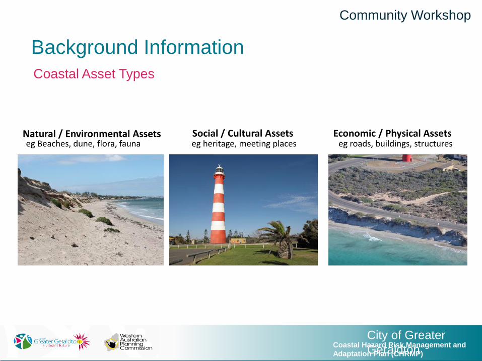
Background Information
Coastal Asset Types
Natural
City of Greater
GeraldtonCoastal Hazard Risk Management and
Adaptation Plan (CHRMP)
City of Greater
GeraldtonCoastal Hazard Risk Management and
Adaptation Plan (CHRMP)
Community Workshop
Background Information
Coastal Asset Types
Natural / Environmental Assets Social / Cultural Assets Economic / Physical Assetseg Beaches, dune, flora, fauna eg heritage, meeting places eg roads, buildings, structures

City of Greater
GeraldtonCoastal Hazard Risk Management and
Adaptation Plan (CHRMP)
City of Greater
GeraldtonCoastal Hazard Risk Management and
Adaptation Plan (CHRMP)
Community Workshop
Questions?
Introductions and Welcome
Project Introduction
Workshop Agenda
Project Background
Task One: Coastal Assets Identification
Consequence Scale Overview
Task Two: Consequence Scale
Short Break
Task Three: Asset Priorities
Preliminary Adaptation Options Presentation
Task Four: Adaptation Strategy
Wrap up and Next Steps

City of Greater
GeraldtonCoastal Hazard Risk Management and
Adaptation Plan (CHRMP)
City of Greater
GeraldtonCoastal Hazard Risk Management and
Adaptation Plan (CHRMP)
Community Workshop
TASK ONE: Coastal Assets Identification
1. What are the coastal assets that are important to you?
2. Why is it important to you?
Categorise as:
• Physical/Economic (road, building)
• Natural/Environmental (vegetation or a reserve)
• Social/Cultural (eg walking, meeting place)
work
individually
20min

City of Greater
GeraldtonCoastal Hazard Risk Management and
Adaptation Plan (CHRMP)
City of Greater
GeraldtonCoastal Hazard Risk Management and
Adaptation Plan (CHRMP)
Community Workshop
Coastal Asset Types
TASK ONE: Coastal Assets Identification
1. What are the coastal assets that are important to you?
2. Why is it important to you?
work
individually
20min
Natural

City of Greater
GeraldtonCoastal Hazard Risk Management and
Adaptation Plan (CHRMP)
City of Greater
GeraldtonCoastal Hazard Risk Management and
Adaptation Plan (CHRMP)
Community Workshop
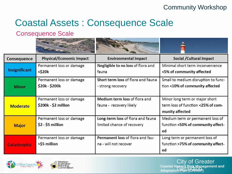
Coastal Assets: Consequence Scale
Lines/Tones On Your Map – What Do They Mean?

City of Greater
GeraldtonCoastal Hazard Risk Management and
Adaptation Plan (CHRMP)
City of Greater
GeraldtonCoastal Hazard Risk Management and
Adaptation Plan (CHRMP)
Community Workshop
Coastal Assets: Consequence Scale
What is Coastal Erosion?
Source: Cardno
Shoreline erosion hazard – ‘Setback’ allowance:
• S1 - current risk of storm erosion
• S2 - historical shoreline movement trends
• S3 - erosion caused by future sea level rise
• Uncertainty

City of Greater
GeraldtonCoastal Hazard Risk Management and
Adaptation Plan (CHRMP)
City of Greater
GeraldtonCoastal Hazard Risk Management and
Adaptation Plan (CHRMP)
Community Workshop
Coastal Assets: Consequence Scale
Source: CardnoDrummond Cove: Coastal Erosion Setback Lines
What is Coastal Erosion?

City of Greater
GeraldtonCoastal Hazard Risk Management and
Adaptation Plan (CHRMP)
City of Greater
GeraldtonCoastal Hazard Risk Management and
Adaptation Plan (CHRMP)
Community Workshop
Coastal Assets : Consequence Scale
What is Storm Surge Inundation?
Storm surge is the rise in the level of the ocean, over and above the regular
astronomical tide, caused by a severe storm such as a tropical cyclone.

City of Greater
GeraldtonCoastal Hazard Risk Management and
Adaptation Plan (CHRMP)
City of Greater
GeraldtonCoastal Hazard Risk Management and
Adaptation Plan (CHRMP)
Community Workshop
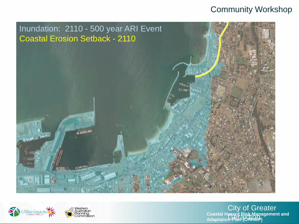
Inundation: 2110 - 500 year ARI Event
Coastal Erosion Setback - 2110
City of Greater
GeraldtonCoastal Hazard Risk Management and
Adaptation Plan (CHRMP)
City of Greater
GeraldtonCoastal Hazard Risk Management and
Adaptation Plan (CHRMP)
Community Workshop
Inundation: 2110 - 500 year ARI Event
Coastal Erosion Setback - 2110
City of Greater
GeraldtonCoastal Hazard Risk Management and
Adaptation Plan (CHRMP)
City of Greater
GeraldtonCoastal Hazard Risk Management and
Adaptation Plan (CHRMP)
Community Workshop
Coastal Assets : Consequence ScaleConsequence Scale

City of Greater
GeraldtonCoastal Hazard Risk Management and
Adaptation Plan (CHRMP)
Coastal Assets : Consequence Scale
Asset Example No.1: Marine Terrace
Community Workshop
Physical/Economic Asset
Erosion: Moderate
Permanent loss or damage $200k - $2
million
Inundation: Minor
Permanent loss or damage $20k - $200k
Loss of connectivity

City of Greater
GeraldtonCoastal Hazard Risk Management and
Adaptation Plan (CHRMP)
City of Greater
GeraldtonCoastal Hazard Risk Management and
Adaptation Plan (CHRMP)
Community Workshop
Coastal Assets : Consequence ScaleAsset Example No.1: Marine Terrace
What is the Consequence of Erosion & Inundation?

City of Greater
GeraldtonCoastal Hazard Risk Management and
Adaptation Plan (CHRMP)
Coastal Assets : Consequence Scale
Asset Example No.2 Foreshore Reserve and Beach
Community Workshop
Environmental Asset
Erosion: Catastrophic
Permanent loss of flora and fauna - will not recover
Inundation: Minor
Short term loss of flora and fauna - strong recovery
Social Asset
Erosion: Catastrophic
Long term or permanent loss of function >75% of
community affected. Loss of recreation space
Inundation: Insignificant
Minimal short term inconvenience <5% of community
affected

City of Greater
GeraldtonCoastal Hazard Risk Management and
Adaptation Plan (CHRMP)
City of Greater
GeraldtonCoastal Hazard Risk Management and
Adaptation Plan (CHRMP)
Community Workshop
Coastal Assets : Consequence ScaleAsset Example No.2 Foreshore Reserve and Beach
What is the Consequence of Erosion & Inundation?

City of Greater
GeraldtonCoastal Hazard Risk Management and
Adaptation Plan (CHRMP)
Coastal Assets : Consequence Scale
Asset Example No.3: Geraldton Surf Life Saving Club
Community Workshop
Social Asset
Erosion: Catastrophic
Long term or permanent loss of function
>75% of community affected loss of
social venue
Inundation: Minor
Permanent loss or damage $20k - $200k

City of Greater
GeraldtonCoastal Hazard Risk Management and
Adaptation Plan (CHRMP)
City of Greater
GeraldtonCoastal Hazard Risk Management and
Adaptation Plan (CHRMP)
Community Workshop
Coastal Assets : Consequence ScaleAsset Example No.3: Geraldton Surf Life Saving Club
What is the Consequence of Erosion & Inundation?

City of Greater
GeraldtonCoastal Hazard Risk Management and
Adaptation Plan (CHRMP)
Coastal Assets : Consequence Scale
Asset Example No.4: The CBD
Community Workshop
Economic Asset
Erosion: Catastrophic
Permanent loss or damage >$5 millionInundation: Catastrophic
Permanent loss or damage >$5 million

City of Greater
GeraldtonCoastal Hazard Risk Management and
Adaptation Plan (CHRMP)
City of Greater
GeraldtonCoastal Hazard Risk Management and
Adaptation Plan (CHRMP)
Community Workshop
Coastal Assets : Consequence ScaleAsset Example No.4: The CBD
What is the Consequence of Erosion & Inundation?

City of Greater
GeraldtonCoastal Hazard Risk Management and
Adaptation Plan (CHRMP)
City of Greater
GeraldtonCoastal Hazard Risk Management and
Adaptation Plan (CHRMP)
Community Workshop
TASK TWO: Coastal Assets Consequence Scale
Examine the coastal assets you identified in Task 1.
For each asset, determine a consequence of erosion and inundation.
Group Work
40min

City of Greater
GeraldtonCoastal Hazard Risk Management and
Adaptation Plan (CHRMP)
City of Greater
GeraldtonCoastal Hazard Risk Management and
Adaptation Plan (CHRMP)
Community Workshop
TASK TWO:
Examine the coastal assets you identified in Task 1.
For each asset, determine a consequence of erosion and inundation.
Consequence Scale
Group Work
40min
City of Greater
GeraldtonCoastal Hazard Risk Management and
Adaptation Plan (CHRMP)
City of Greater
GeraldtonCoastal Hazard Risk Management and
Adaptation Plan (CHRMP)
Community Workshop
Short Break
Please return to your seats in…
5 minutes

City of Greater
GeraldtonCoastal Hazard Risk Management and
Adaptation Plan (CHRMP)
City of Greater
GeraldtonCoastal Hazard Risk Management and
Adaptation Plan (CHRMP)
Community Workshop
TASK THREE: Priority Assets
Re-examine your table’s coastal assets from Task 1.
Use your 5 sticky dots to identify priority assets.
You can spread your dots over five individual assets or
place more than one dot on a single asset.
work individually
10min

City of Greater
GeraldtonCoastal Hazard Risk Management and
Adaptation Plan (CHRMP)
City of Greater
GeraldtonCoastal Hazard Risk Management and
Adaptation Plan (CHRMP)
Community Workshop
Adaptation Options
Consequence ScaleLocate assets in areas not at risk
Avoid foredune / low lying areas
Retreat over time as coastal
hazard realised
Planning Controls
Building design
Emergency Evacuation Planning
Seawalls and Flood Walls
Beach nourishment
Groynes
Offshore Breakwater

City of Greater
GeraldtonCoastal Hazard Risk Management and
Adaptation Plan (CHRMP)
City of Greater
GeraldtonCoastal Hazard Risk Management and
Adaptation Plan (CHRMP)
Community Workshop
Adaptation Options: Avoid
Development planning approvals
take into consideration
• Coastal Erosion setbacks; and
• 500yr ARI inundation extents.
No new developments on the
shoreline side of the identified coastal
hazard extent.
Planning Control Examples
Avoid isn’t applicable to existing or historical developments that are at risk.

City of Greater
GeraldtonCoastal Hazard Risk Management and
Adaptation Plan (CHRMP)
City of Greater
GeraldtonCoastal Hazard Risk Management and
Adaptation Plan (CHRMP)
Community Workshop
Adaptation Options: Planned/Managed Retreat
Eg. notification on title, control of further development, apply easement or planning zones
to allow for rolling change of land use as coastal hazard is realised.
• Time based structures
• Leave assets unprotected
Planning Control Examples
City Asset/ValueRemoval of the Triton Place toilet block
Tourism Asset/ValueTwo part lease to take into account land at risk

City of Greater
GeraldtonCoastal Hazard Risk Management and
Adaptation Plan (CHRMP)
City of Greater
GeraldtonCoastal Hazard Risk Management and
Adaptation Plan (CHRMP)
Community Workshop
Adaptation Options: Accommodate Inundation
• Set minimum floor levels based on structure type (Dome Café, Batavia Marina
Development)
• Locate development on least hazardous portion of site
Planning Control Examples
• Lower portion of structure flood resistant
materials and designed to withstand forces
• Modify building design to allow for future
relocation of building
Building Design Examples
http://www.coastalconference.com/2012/papers2012/Greg%20Giles%20and%20Heather%20Stevens%20Full%20Paper.pdf

City of Greater
GeraldtonCoastal Hazard Risk Management and
Adaptation Plan (CHRMP)
Adaptation Options: Accommodate/Protect - Erosion
Whitehill Road in Drummond Cove, St Georges Beach
• Maintains beach amenity
• Mitigates further erosion
• Requires sediment source
• Temporary or short term measure
Community Workshop
Beach Nourishment/ Geo Textile Containers Example

City of Greater
GeraldtonCoastal Hazard Risk Management and
Adaptation Plan (CHRMP)
Adaptation Options: Protect - Erosion
• Midalias Beach
• The Foreshore
Community Workshop
Groynes Example

City of Greater
GeraldtonCoastal Hazard Risk Management and
Adaptation Plan (CHRMP)
Adaptation Options: Protect - Erosion
Community Workshop
Beresford Foreshore
http://www.watoday.com.au/
http://www.watoday.com.au/http://www.watoday.com.au/
Erosion Protection - Seawall Example

City of Greater
GeraldtonCoastal Hazard Risk Management and
Adaptation Plan (CHRMP)
• Many different types, can be
permanent or temporary
• Engineered Rock Seawalls
• Dikes or Levy Banks
www.elitereaders.com/mobile-flood-walls-austria-machlanddamm/
Community Workshop
Adaptation Options: Protect - Inundation
Flood Protection Sea Walls
www.ukflooddefencealliance.com

City of Greater
GeraldtonCoastal Hazard Risk Management and
Adaptation Plan (CHRMP)
City of Greater
GeraldtonCoastal Hazard Risk Management and
Adaptation Plan (CHRMP)
Community Workshop
TASK FOUR: Priority Areas Adaptation Ideas
Group Work
20min
Adaptation Strategies
First Focus on:
Geraldton Town Centre
(Coastal Hazard – Inundation)
Then: Your Table’s Priority Location / Asset
(if time allows)

City of Greater
GeraldtonCoastal Hazard Risk Management and
Adaptation Plan (CHRMP)
City of Greater
GeraldtonCoastal Hazard Risk Management and
Adaptation Plan (CHRMP)
Community Workshop
TASK FOUR: Priority Areas Adaptation Ideas
Group Work
20min

City of Greater
GeraldtonCoastal Hazard Risk Management and
Adaptation Plan (CHRMP)
City of Greater
GeraldtonCoastal Hazard Risk Management and
Adaptation Plan (CHRMP)
Community Workshop
TASK FOUR: Priority Areas Adaptation Ideas
Group Work
20min
Adaptation Strategies
First Focus on:
Your Table’s No.1 Priority Location / Asset
Then: Your Table’s No.2 Priority Location / Asset
(if time allows)

City of Greater
GeraldtonCoastal Hazard Risk Management and
Adaptation Plan (CHRMP)
City of Greater
GeraldtonCoastal Hazard Risk Management and
Adaptation Plan (CHRMP)
Community Workshop
TASK FOUR: Priority Areas Adaptation Ideas
Group Work
20min

City of Greater
GeraldtonCoastal Hazard Risk Management and
Adaptation Plan (CHRMP)
City of Greater
GeraldtonCoastal Hazard Risk Management and
Adaptation Plan (CHRMP)
Community Workshop
Please watch the City’s Webpage for regular project updates.
SurveyThe deadline to complete the survey is 8am, Monday 23 October 2017.
www.surveymonkey.com/r/GeroCAP
Next Steps
How Can I Be Involved?

City of Greater
GeraldtonCoastal Hazard Risk Management and
Adaptation Plan (CHRMP)
City of Greater
GeraldtonCoastal Hazard Risk Management and
Adaptation Plan (CHRMP)
Community Workshop
Thank you!
Please take the time to fill out the post workshop survey

City of Greater
GeraldtonCoastal Hazard Risk Management and
Adaptation Plan (CHRMP)
City of Greater
GeraldtonCoastal Hazard Risk Management and
Adaptation Plan (CHRMP)
Community Workshop

City of Greater
GeraldtonCoastal Hazard Risk Management and
Adaptation Plan (CHRMP)
City of Greater
GeraldtonCoastal Hazard Risk Management and
Adaptation Plan (CHRMP)
Community Workshop
Background Information
CHRMAP Adaptation Responses
• Adaptation responses to manage coastal hazard risk are developed using the adaptation hierarchy (WAPC)
Avoid new development within an area of Coastal Hazard
Relocation or Removal of Assets over the planning timeframe
Management Strategies to control the risk (eg Bldg Design, Planning)
Protection of assets (eg seawalls, groynes, sand nourishment)

City of Greater
GeraldtonCoastal Hazard Risk Management and
Adaptation Plan (CHRMP)
City of Greater
GeraldtonCoastal Hazard Risk Management and
Adaptation Plan (CHRMP)
Community Workshop
Background Information
Likelihood Probability for ARI Events
Annual Chance of not happpenning 10yrs 20yrs 30yrs 50yrs 100yrs
50 yr 2% 0.02 0.98 18% 33% 45% 64% 87%
100yr 1% 0.01 0.99 10% 18% 26% 39% 63%
500yr 0.20% 0.002 0.998 2% 4% 6% 10% 18%

City of Greater
GeraldtonCoastal Hazard Risk Management and
Adaptation Plan (CHRMP)
City of Greater
GeraldtonCoastal Hazard Risk Management and
Adaptation Plan (CHRMP)
Community Workshop
Background Information
CHRMAP Risk Assessment
• The likelihood of coastal hazard describes the chance of an event occurring in probable terms
• Almost Certain• Likely• Probable• Unlikely
• Recognises likelihood changes over time AND the uncertainty in making future predictions
Almost CertainLikelyPossibleUnlikely
LEGEND: LIKELIHOOD 2070

City of Greater
GeraldtonCoastal Hazard Risk Management and
Adaptation Plan (CHRMP)
City of Greater
GeraldtonCoastal Hazard Risk Management and
Adaptation Plan (CHRMP)
Community Workshop
Background Information
CHRMAP Risk Assessment
• Risk is a product of Likelihood and Consequence
• The risk assessment identifies coastal risks in highest need of response ie risk level Extreme or High
• Adaptation responses are developed to mitigate risk
• Note it is impossible / impractical to mitigate all risks


