COASTAL SEDIMENTATION AND COASTAL MANAGEMENT OF FONGAFALE, FUNAFUTI ATOLL TUVALU Chungting Xue' and Faatasi Malologa2 September 1995 SOPAC Technical Report 221 1 SOPAC Sectetariat *Lands and Survey Department, Tuvalu This project was funded by the Government of the People's Republic of China
Transcript
COASTAL SEDIMENTATION AND COASTAL MANAGEMENT OF FONGAFALE, FUNAFUTI ATOLL
TUVALU
Chungting Xue' and Faatasi Malologa2
September 1995 SOPAC Technical Report 221
1 SOPAC Sectetariat *Lands and Survey Department, Tuvalu
This project was funded by the Government of the People's Republic of China
I Data of the Sections near Vaiaku Lagi Hotel...................................................................51 II Volume of Gravel Needed to replenish the beach and nearshore near Vaiaku Lagi Hotel .............................................................................................................53 III Volume of gravel at the southwest end of Fongafale Island that could be exploited......................................................................................................................54
[4]
[TR221 – Chunting & Malologa]
LIST OF FIGURES
Figure
1 Location map ....................................................................................................................... 9 2 Geographical division, lagoon-side coral flat provinces and beach regions of Fongafale.............................................................................................10 3 The sand beach, lake and surrounding mangrove in central Fongafale.......................................13 4 Lagoon side coastal change of Fongafale in the Second World War .........................................15 5 Coastal geology of the lagoon shore and reef of Fongafale .................................. see back pocket 6 Classification of lagoon-side coral flat of Fongafale..................................................................17 7 Relationship between the "intermittent spring" and incident waves ............................................18 8 Classification and evolution of lagoon-side beaches of Fongafale ..............................................21 9 The lagoon-side sand beach in the central coral flat province of Fongafale ........................................................................................................................22 10 Sand (light) and patch reef (dark) in the central coral flat province.............................................22 11 The beachrock with erosion scarp in the north beach region.....................................................23 12 The sand beach in the north beach region ..............................................................................23 13 Relations between the lagoon-side longshore current direction and wind direction................................................................................................................25 14 The sediments and relative heights of the sediment and ramp surfaces, 225 m southwest of the discussed Vaiaku Wharf......................................................26 15 The sediments beside the disused Vaiaku Wharf (a jetty type wharf) ........................................26 16 Elevations of sediment surface beside the jetty close to Vaiaku Lagi Hotel ................................................................................................................27 17 Sediments beside Funafuti Wharf, a pier type wharf, north arm of Fongafale..................................................................................................................27 18 The retreat of the shoreline (vegetation line) near BS19 since 1973...........................................31 19 The retreat of the shoreline (vegetation line) near Co-op Warehouse since 1973.........................................................................................................31 20 Coastal erosion to northeast of BS3 ......................................................................................33 21 Coastal erosion to northeast of BS3 ......................................................................................33 22 Growth of the south end of Fongafale Island since 1943...........................................................34 23 The gravel accumulation area at the south end of Fongafale Island ...........................................36
[5]
[TR221 – Chunting & Malologa]
24 Cross sections in the gravel accumulation area at the south end of Fongafale Island...............................................................................................................37 25 The oceanside of the gravel accumulation at the south end of Fongafale Island ..................................................................................................................38 26 The lagoonside of the gravel accumulation and the recent accretion with vegetation cover at the south end of Fongafale .................................................................38 27 The south end of Funafara Island and the north end of Telele Island ..........................................39 28 Evolution of Fongafale Island.................................................................................................40 29 A section showing sand coast progradation lagoonward ..........................................................42 30 The concrete seawall and boulders on the beach in front of Vaiaku Lagi Hotel ...........................................................................................................................44 31 The cemented boulder seawall and boulders on the beach in front of Vaiaku Lagi Hotel.............................................................................................................44 32 Piled concrete cubes forming seawall in the southwest of Catalina Ramp.....................................................................................................................45 33 Bathymetry near Vaiaku Lagi Hotel .......................................................................................46 34 Beach and coral flat sections in the central area of Fongafale ..................................................47 35 Accumulation of gravel without vegetation cover at the south end of Funangongo Island ...........................................................................................................48
[6]
[TR221 – Chunting & Malologa]
ACKNOWLEDGEMENTS
Funds for this project were contributed by the Goverment of the People’s Republic of China. The
Department of Lands and Survey of Tuvalu provided a vehicle for field work. Appreciation is
extended to Dr D.L. Forbes for the useful comments on early drafts of the report.
[7]
[TR221 – Chunting & Malologa]
SUMMARY
Fongafale is a long narrow island with a broad "V"-shaped outline and is divided into three
geographical areas: the south arm, the central area and the north arm. This morphology controls
the pattern of the longshore currents on the lagoonside, which transport sand from both the
northeast and southwest towards the central area, resulting in well-established beaches in the
central area before World War II. The coral flat can be classified into two types and divided into
three provinces. The beach is classified into two types and divided into three regions. The good
symmetries of division of coral flat provinces and beach regions are controlled by the longshore
currents. A model for the formation of Fongafale Island is proposed.
Modification of the lagoonside of the island during WWII include a 2.3 km long piece of reclamation
with coral rock seawall, a long borrow pit (often called a channel) beside it, and other channels
normal or parallel to the seashore on the lagoonside. These developments changed the shoreline
and sedimentation patterns. The seawall was placed at about the former low-tide line and suffered
erosion after it was built. The borrow pit or channel has been filled with sand transported by wave
and longshore currents and with sand and gravel eroded from the reclaimed land. The natural
trend is to fill the channel and erode the reclaimed land, as nature attempts to recover the natural
beach gradient.
Beach recovery could be promoted by replenishing gravel on the beach and adjacent nearshore
surface near the Vaiaku Lagi Hotel, to form a slope on which sand many accumulate naturally. In
recent years gravel has accumulated at the southern end of Fongafale and the ends of the other
islands, which can be used to nourish the beach.
[8]
[TR221 – Chunting & Malologa]
OBJECTIVES
The objectives of the survey of the lagoon-side coast in Fongafale, Funafuti,Tuvalu were to:
1. study coastal process with emphasis on coastal erosion, sand transport and sedimentation;
and to
2. study coastal management especially the possibility of beach renourishment i.e. how to get the
nourishment material and if the sand can be kept on the beach.
INTRODUCTION
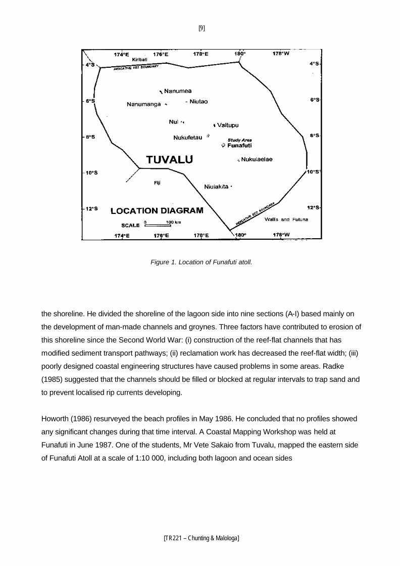
Fongafale is the main island (islet or motu) of Funafuti Atoll in Tuvalu (Figure 1). It is 1.42 km2 in
area, long and narrow with a broad "V" shaped outline and can be divided into three geographical
areas (Figure 2): (i) the south arm, extending southwestward 2.3 km, from 150 m southwest of the
south end of the runway or the point of the lost beach profile base station BS16; (ii) the central
area, from BS16 north approximately 2 km to Teuaea Road; (iii) the north arm, extending
northeastward 4.5 km from Teuaea Road. The central area is relatively wide and the north and
south arms are narrow. The maxium elevation on Fongafale is less than 3 m, and coastal erosion
occurs primarily on the lagoon ( western) side.
Previous Work
The previous work can be summarised as follows: beach profile monitoring from 1982 to 1995;
current measurements (Carter, 1986b; Rearic, 1991).
Fawcett and Partners (1982) documented coastal erosion on Fongafale and established 18 beach
profiles on the lagoon side of Vaiaku, the main residential area in Fongafale. In the same area,
Radke (1985; field work in 1984) established 22 beach profiles. He also completed a bathymetry
survey and a geological map (1:2 500) from the lagoon shoreline out to about 12 m water depth.
He noted that sand was being lost beyond the lagoon reef edge because longshore transport was
disrupted by channels and groynes perpendicular to
[9]
[TR221 – Chunting & Malologa]
Figure 1. Location of Funafuti atoll.
the shoreline. He divided the shoreline of the lagoon side into nine sections (A-I) based mainly on
the development of man-made channels and groynes. Three factors have contributed to erosion of
this shoreline since the Second World War: (i) construction of the reef-flat channels that has
modified sediment transport pathways; (ii) reclamation work has decreased the reef-flat width; (iii)
poorly designed coastal engineering structures have caused problems in some areas. Radke
(1985) suggested that the channels should be filled or blocked at regular intervals to trap sand and
to prevent localised rip currents developing.
Howorth (1986) resurveyed the beach profiles in May 1986. He concluded that no profiles showed
any significant changes during that time interval. A Coastal Mapping Workshop was held at
Funafuti in June 1987. One of the students, Mr Vete Sakaio from Tuvalu, mapped the eastern side
of Funafuti Atoll at a scale of 1:10 000, including both lagoon and ocean sides
[10]
[TR221 – Chunting & Malologa]
Figure 2. Geographical division, lagoon-side coral flat provinces, and beach regions of Fongafale.
[11]
[TR221 – Chunting & Malologa]
of Fongafale, based mainly on aerial photographs and partly on site investigation (Richmond and
Howorth, 1989). The participants also resurveyed the beach profiles on the lagoon side and
concluded that erosion dominated over accretion. Strong westerlies coinciding with the build-up of
Cyclone Tusi in early 1987 caused erosion at many sites (Howorth, 1991).
Because channel and groyne structures come close to, and in some cases intersect the
shoreline, the character of the shoreline has been affected and is still re-equilibrating since they
were constructed. There appears to be a dramatic reduction of sand on the beaches, and a
consequent natural armouring with cobble-boulder material. Most of the shoreline is exposed to
westerly storm conditions that account for a significant proportion of the sediment transport on the
lagoon side (Howorth and Radke, 1991).
Carter (1985, 1986a) studied aspects of the oceonography of Funafuti Atoll. Wave data were
obtained from the ocean side by visual observations of a wave staff erected in the breaker zone,
and for the lagoon side waves were hindcast from the wind data. Two current meter stations were
occupied to observe currents within the lagoon; one was west of the north end of the runway, in 5
m water depth; and the second was located off the end of Funafuti Wharf, in 8 m water depth.
However, the currents observed (during July) were too weak to transport sand, implying that
waves may be more significant for sand transport on the east side of the lagoon than tide- and or
wind-driven currents (Carter, 1986b).
A current meter was placed about 75 m offshore near Vaiaku Lagi Hotel, where there has been
considerable erosion and breakdown of a concrete seawall in recent years. Several short-duration
westerly storms occurred during the deployment of the current meter.
Gillie and Harper (1992) tabulated and plotted data for all available beach profiles over the duration
of the beach profile monitoring program from 1984 to 1991. Since 1987, these data include six
resurveys of the profiles by the Lands and Survey Department between August 1988 and
September 1991. An in-country seminar on beach monitoring was held in Funafuti in 1994,
enabling another survey of the profiles (Howorth and Woodward, 1994). The beach profiles were
most recently surveyed in February 1995 (Woodward, 1995).
[12]
[TR221 – Chunting & Malologa]
Present Study
From 6 April to 15 May 1995, field work was carried out on the lagoon side coast of Fongafale in
order to produce a coastal geological map (scale 1:2500), to study coastal processes with an
emphasis on coastal erosion, sediment transport and to deposition, and to determine the evolution
of Fongafale Island.
Transects were surveyed at 200 m intervals across the reef flat at low tide and observations on
the beach were made along most of the shoreline. From 800 m north of Funafuti Wharf to the
north end of Fongafale, the transects were spaced at 500 m.
The 1:2500 topographic map, published in 1979 by the British Government's Overseas
Development Administration (Directorate of Overseas Surveys) was used for a base map. This
map was produced from aerial photographs taken in July and August 1973 by the Royal Air Force.
Field checking of the map was done by the Tuvalu Land and Surveys Division in August 1978;
however, the map mainly shows the situation in 1973. On the geological map produced during this
study the coastline has been altered only where there was obvious change.
Change in the Lagoon Coastline during the WWII
Senior residents remember that there was a long, low-gradient, sandy beach prior to the Second
World War. David (1904) recorded that there was an extensive sandy beach at the turn of the
century. Aerial photographs taken on 26 June 1941 show most parts of this beach, which extended
from the position of BS16 at least as far north as the present Primary School (Figure 3). The state
of the coastline to the south and north of this beach at that time is unknown. Aerial photographs
taken on 9 July 1943 show that most of the beach had been covered by reclaimed land, with sandy
beach remaining only to the north of the present Teuaea Road (Figure 4). The sandy beach
extending from BS16 to Teuaea Road before 1942, along the central part of Fongafale, was about
30 m wide and 2 km long.
When the US forces arrived in Funafuti in October 1942, there was a lake with surrounding
mangroves in the north part of the central area of Fongafale. In order to build a longer runway, a
large volume of gravel had to be dug from the land area to fill in the lake and
[13]
[TR221 – Chunting & Malologa]
Figure 3. The sand beach, lake and surrounding mangrove in central Fongafale, based on aerial photographs taken 26 June 1941.
[14]
[TR221 – Chunting & Malologa]
mangroves. Sand dug from the lagoon was used for paving the runway, and an area 2 km long
and 25-40 m wide was reclaimed along the lagoon shore to provide an access road. This
extended from 90 m northeast of Catalina Ramp to 370 m southwest of the present runway. A long
borrow pit was dredged, more than 10 m wide, forming a channel parallel to the shore. Another
access road connected the shore and the runway (Figure 4). The Catalina Ramp was the
seaplane base and there was a borrow pit beside and in front of the ramp. A shore-normal channel
35 m wide was dredged 450 m southwest of the south end of the present runway for a petrol
torpedo (P.T.) boat base. A road was built from here to the south end of the shore access road,
using stone and sand dredged from a borrow pit at the toe of the beach. The result was 2.3 km of
reclaimed land with a coral stone seawall and a long borrow pit (often called a channel)
immediately beside it in the reef flat. In the north area, two other channels normal to the shore and
one 125 m long channel parallel to the shore near the present Tuvalu Co-operative Wholesale
Society were also dug.
These developments completely changed the shoreline and sediment transport patterns along the
lagoon side of Fongafale. The seawall was placed at about the former low-tide line and suffered
erosion soon after it was built. The borrow pits or channels have been filled with sand transported
by waves and longshore currents and with sand and gravel eroded from the reclaimed land.
However, land in Fongafale is very limited and valuable, so people have been making efforts to
keep the reclaimed land. This leads to a conflict between the natural processes and the desires of
the people. After destruction of the coral stone seawall built in the Second World War, gabion
basket seawalls were built. Only small parts of these have survived. In recent years, seawalls of
concrete cubes have been built from Teuaea Road south to the disused Vaiaku Wharf, along with
a vertical stone-cemented seawall and concrete seawall in the front of the new Vaiaku Lagi Hotel.
Along the shoreline to the north and south of the central Vaiaku area, few man-made changes
have taken place. Erosion has occurred but the scale is much smaller than that in the central area
of artificial shore.
Lagoon Reef Flat
The lagoon reef flat is 55-350 m wide, including a 15-25 m wide beach. It consists of three
provinces (Figures 2 and 5):
[15]
[TR221 – Chunting & Malologa]
Figure 4. Lagoon side coastal change of Fongafale in the Second World War, based on the aerial photographs taken 9 July 1943 and interviews with senior local residents.
[16]
[TR221 – Chunting & Malologa]
Figure 5. Coastal geology of the lagoon shore and reef of Fongafale. (see pocket at end of the Report)
(i) the south province, south of the disused Vaiaku Wharf;
(ii) the central province, from the disused Vaiaku Wharf to the Catalina Ramp; and
(iii) the north province, north of the Catalina Ramp.
The coral flat is classified into two types :
� Type I: coral reef pavement with beachrock and/or loose sediments;
� Type II: sand and patch coral with sandy beach.
Type I
This occurs in the south and north provinces. The coral reef flat pavement is composed of coral
reef in the outer western part (lagoonward) and beachrock partly coved with sediments or loose
sediments in the inner part (Figures 5 and 6).
Exposed beachrock is mostly conglomerate, about 50 m wide and continuous along the shore.
Because almost all of the beachrock below the low tide level is covered by green algae, accurately
identifying the character of this beachrock is difficult. The outline of the clasts is obscure in a fresh
surface, because both the rubble and the cement (smaller organic fragments) are carbonate. In
places, conglomerate without green algae can be recognised 35 m from the shore at low spring
tide.
The coral pavement itself is not stratified and has some void spaces in the subsurface, as can be
seen to the south of the disused Vaiaku Wharf, and the upper surface is typically uneven. In
contrast, the beachrock is typically stratified, without voids, and always has an even upper surface
except in the beach area. The beachrock may lie on domal and massive coral, or with a thin layer
of green algae and loose sand between. After erosion, some holes ranging in size from a few
centimetres to tens of centimetres may penetrate the beachrock. Water flow produced by waves
entering the space between the beachrock and underlying
[17]
[TR221 – Chunting & Malologa]
Figure 6. Classification of lagoon-side coral flat of Fongafale. See Figure 5 for location of the sections.
[18]
[TR221 – Chunting & Malologa]
coral reef and then exits from the holes, forming "intermittent springs" with the same period as the
incident waves (Figure 7). This phenomenon is common near the outer boundary of the beachrock
and is a good way to differentiate beachrock from the coral pavement.
To build the Fishing Wharf piers in 1982, a section of beachrock, 50 m wide and 150 m long, was
dug away. The stratified beachrock is clearly seen in section here at low spring tide. The
beachrock thickness diminishes lagoonward as shown in Table 1.
Figure 7. The relation between the "intermittent spring" and incident waves. The water surge produced by the incoming wave passes between the beachrock and underlying coral rock and exits through holes in the beachrock.
Table 1. Thickness of beachrock on coral flat near Fishing Wharf.
Distance from seashore (m) 8-11.5 24 31 38 43 49
Thickness of beachrock (m) >1.40 0.43 0.60 0.55 0.25 0.25
Most of the corals on the reef flat are dead but a few corals survive near the western rim of the
coral flat. The reef consists of a domal and massive coral zone or a branching coral zone or both
(Figure 6).
The sand cover is about 20-40% over the zone of domal and massive corals and commonly the
sands are very thin (a few centimetres). Most domal and massive corals are encrusted with green
algae. If there is no branching coral zone outside, a few living stubby branching corals occur near
the rim of the domal and massive zone, the reef face commonly is sloping without a very clear
boundary but in some areas is steep with a clear boundary. If a branching coral zone is present
[19]
[TR221 – Chunting & Malologa]
outside, some dead stubby branching corals and plate-like corals without encrustation can be
seen and there are no living coals in the domal and massive zone.
Stubby branching corals and some fasciculate corals were growing in the branching coral zone
before and only a few living corals are growing there now. There are great void spaces between
corals and no sand on the surface. The face of the reef is vertical and even overhanging. The reef
flat is about 3 m higher than the adjacent lagoon bed.
Type II
This occurs in the central province (Figures 2 and 5). It consists of sand and patch coral reef with
sandy beach (Figure 6). Under natural conditions, all of the beach was covered by sand. Sand and
patch coral reef occurs outside of the beach. The sand cover, which is tens of centimetres or
more thick, is 60-70% of the total area. The remaining 30-40% is occupied by patch reef, mainly
composed of domal and massive corals encrusted by green algae (Figures 6, 9 and 10). Some
stubby branching and fasciculate corals without encrustation occur on the outer part of the flat.
Lagoon Beach
The beach is divided into three regions :
(i) the south region, extending from BS16 to the south end of Fongafale Island. It
coincides with the south arm of Fongafale by geographic division;
(ii) the central region, from BS16 to Teuaea Road. It coincides with the central area
of Fongafale; and
(iii) the north region, extending from Teuaea Road to the north end of Fongafale
Island. It coincides with the north arm of Fongafale.
Relative to the boundaries of the central coral flat province, the central beach region extends
further north and south.
The beach is classified into two types (Figure 8).
� Type 1 : beachrock with partial cover of loose sediment (mostly gravel).
� Type 2 : sand covers all of the beach.
[20]
[TR221 – Chunting & Malologa]
Type 1
Type 1 is distributed throughout the south and north regions (Figures 2 and 5). Most of the
beachrock is poorly cemented conglomerate or conglomerate limestone, composed of various-
sized grains of organic fragments (coral, bivalves, gastropods and others). The conglomerate
beachrock has poor stratification but commonly the rubble in the beachrock can be seen to dip
lagoonward. A limited area of beachrock made up of predominantly sand-size fragments just
south of the High School has good stratification dipping lagoonward.
This type of beach appears in different forms (Figure 8).
Form 1 : The beachrock has an obvious erosion scarp 30-90 cm high. Commonly gravel
accumulates at the foot of the scarp and always gravel accumulates close to the vegetation line
(Figure 11).
Form 2 : Gravel accumulates close to the vegetation line and the rest of the beach is occupied by
bare beachrock without a distinct erosion scarp. This form has evolved from Form 1, as the
erosion scarp gradually becomes lower and lower.
Form 3 : Most parts of the beach are covered with gravel but some beachrock crops out above the
surrounding sediment due to differential erosion. This form has evolved from Form 1.
Form 4 : Most parts of the beach are covered with gravel (mostly cobbles), rarely with sand
(Figure 12) and very little of the beachrock is exposed. This form has evolved from Forms 1 or 2 or
3.
[21]
[TR221 – Chunting & Malologa]
Figure 8. Classification and evolution of lagoon-side beaches of Fongafale.
[22]
[TR221 – Chunting & Malologa]
Figure 9. The lagoon-side sand beach, with sand covered (light) and patch-reef (dark) coral flat in the central
coral flat province of Fongafale.
Figure 10. Sand (light) and patch reef (dark) in the central coral flat province, with sand beach in the foreground.
[23]
[TR221 – Chunting & Malologa]
Figure 11. The beachrock with erosion scarp in the north beach region.
Figure 12. The sand beach in the north beach region. A thin sand layer covers the beachrock.
[24]
[TR221 – Chunting & Malologa]
Type 2
The beach sands are commonly as thick as 2 m. There is no beachrock under the sand, except in
limited parts, in the north end and maybe in the south end of the central beach region. This type of
beach was well developed along the lagoon shore of the central area of Fongafale before the
Second World War (Figures 2 and 3), but now most of the lagoon shore is covered by boulders
and concrete cubes (Figure 5).
The distribution of the beachrock almost coincides with the geographic division of the island and
regional division of the beach. The beachrock is formed mainly along the south and north arms of
the islands. A small length of beachrock (about 75 m) is exposed at the north end of the central
area.
COASTAL SEDIMENTATION
Type I reef flat occurs in the south and north provinces and Type II in the central province, showing
good symmetry. The Type 1 beach is restricted to the south and north regions and the Type 2 to
the central region, with good symmetry too. This pattern results from coastal sedimentation,
closely related to longshore currents, which are controlled by the symmetric island outline.
Fongafale is located on the east rim of Funafuti Atoll. Futato is situated to southwest of Fongafale,
and a 1.5 km long coral flat, of which the middle part is exposed at low tide, has developed
between the two islands. To the north, a 25 m long causeway, which was built during the Second
World War, connects Fongafale and Tengako. The south arm of Fongafale extends about 2.5 km
along a bearing of 235º. The north arm (about 4.5 km) and Tengako extend on a bearing of 342º.
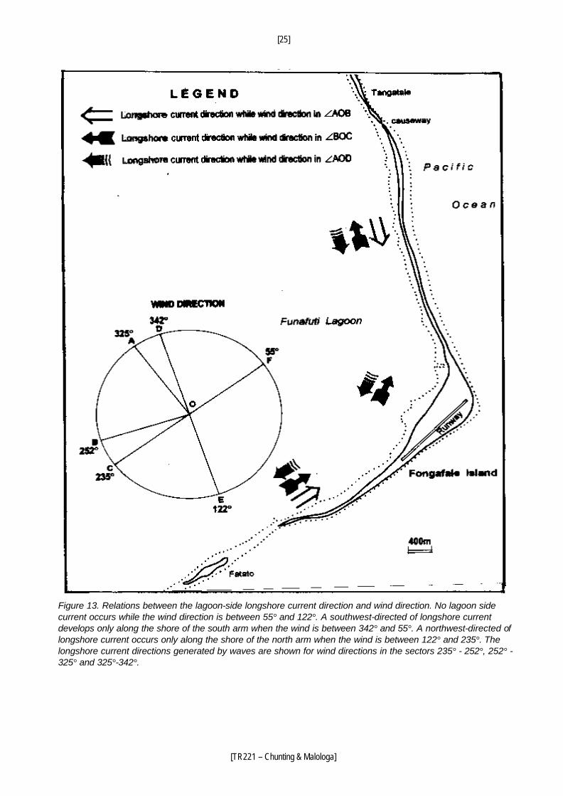
The relation between wind direction and longshore currents, constrained by the atoll morphology,
is shown in Figure 13. During December through March, stronger west and northwest winds occur
(Carter,1984b). The longshore currents on the lagoon side of Fongafale occur mostly in these
seasons.
The differences in beach volume between opposide sides of groynes (jetties and wharfs) show
that the dominant longshore current is southeastward along the north arm and northeastward
along the south arm (Figures 14-17).
[25]
[TR221 – Chunting & Malologa]
Figure 13. Relations between the lagoon-side longshore current direction and wind direction. No lagoon side current occurs while the wind direction is between 55° and 122°. A southwest-directed of longshore current develops only along the shore of the south arm when the wind is between 342° and 55°. A northwest-directed of longshore current occurs only along the shore of the north arm when the wind is between 122° and 235°. The longshore current directions generated by waves are shown for wind directions in the sectors 235° - 252°, 252° - 325° and 325°-342°.
[26]
[TR221 – Chunting & Malologa]
Figure 14. The sediments and relative heights of the sediment and ramp surfaces, 225 m southwest of the discussed Vaiaku Wharf. Accumulation on the southwest side and erosion on the northeast side of the jetty, showing the dominant northeast longshore current.
Figure 15. The sediments beside the disused Vaiaku Wharf (a jetty type wharf). Accumulation on the southwest side and erosion on the northeast side of the wharf, showing the dominant northeast longshore current. The boulders are an erosional lag and the concrete cubes are artificially placed northeast of the wharf.
[27]
[TR221 – Chunting & Malologa]
Figure 16. Elevations of sediment surface beside the jetty close to Vaiaku Lagi Hotel. Accumulation on the southwest side and erosion on the northeast side of the jetty, showing the dominant northeast longshore current.
Figure 17. Sediments beside Funafuti Wharf, a pier type wharf, north arm of Fongafale (see Figure 5 for location). Accumulation on the northwest side and erosion on the southeast side at the base of the wharf, showing the dominant southeast longshore current.
[28]
[TR221 – Chunting & Malologa]
It is clear that the longshore currents control the coral flat and beach sedimentation. The domal
and massive coral zone in the north and south coral flat provinces have a 20-40% cover of thin
sand (a few centimetres thick). Sand is transported to the central coral flat province by longshore
currents. Gravel, commonly in a zone 3-6 m wide, mostly accumulates on the beachrock near the
vegetation line in the north and south arm areas. This results from wave action. Sand usually fills
the void between gravels and is transported to the central region by longshore currents.
Thicker sand (tens of centimeters thick) accumulates on the beachrock only under special
conditions, such as near the High School in the north arm. The underlying beachrock is easily
eroded, forming a shallow basin, in which sand is deposited (Figures 5 and 12).
Sand transported by the longshore and shoreward currents accumulates on the beach in the
central region, especially in the central coral flat province. However, because of human activity
(primarily the changes during the early 1940s), the coast in the central beach region is unstable
and most of the beaches are now covered by boulders and concrete cubes.
After a long interval of erosion, accumulation has begun again in a limited area of the beach 40-140
m southwest of BS5, in the central area of Fongafale. Sand (or gravelly sand) about 30-80 cm
thick covers the gravel in this area. The sand beach is about 26 m wide with a slope of 5º, the
lowest gradient along the beach (Figures 8 and 9). This is the centre to which sediments are
transported by longshore currents from both the northwest and southwest.
Branching corals (which prefer current flow) occur in a zone on the outer flat in the north part of
the north arm and the south part of the south arm, where current activity is more vigorous. Close
to the south end of Fongafale, where some ocean water joins the longshore lagoon current, the
corals are exclusively of branching form.
Effects of Human Activity upon Sedimentation
The only parts of the island to have escaped significant human modification are the outer areas,
from the south end of Fongafale Island to the disused P.T. boat base and from Funafuti Wharf to
the north end of Fongafale.
[29]
[TR221 – Chunting & Malologa]
As mentioned above, a 2.3 km long borrow pit (channel) was dug in World War II along the lagoon
shore. We have no information about the depth. The channel was dug by powerful machines (the
remains of a caterpillar excavator still lie on the coral flat near Catalina Ramp). It can be estimated
that the depth was more than 2 m. Sand and some gravel transported directly by waves and
associated shoreward currents must have been deposited in the channel, which also receives the
sediment transported by longshore currents and backwash. The adjacent beach is in a sediment-
starved condition. Only a small part of the channel has been completely filled, but much of it is
close to being full.
Six channels normal to the shore (at the disused P.T. boat base, the disused Vaiaku Wharf, the
disused seaplane landing ramp-Catalina Ramp, the channel south of Tuvalu Co-operative
Wholesale Society, the channel north of Tuvalu Co-operative Wholesale Society and the Fishing
Wharf) provide good passages for rip currents (Radke, 1985). These currents maintain high
velocities along the channels. If there were no shore-normal channels, rip currents would still form
but the current velocities would dissipate across the coral flat. In contrast to the shore-parallel
channels, these shore-normal channels are still relatively deep.
The jetties and ramps acting as groynes block the longshore transport of sediments on the updrift
side and cause erosion on the downdrift side, as at the disused Vaiaku Wharf, the ramp 230 m
southwest of the wharf and the jetty close to Vaiaku Lagi Hotel (Figures 14, 15 and 16). Funafuti
Wharf and the Fishing Wharf are pier strutures, which have less effect on coastal sedimentation,
except at the base of Funafuti Wharf (Figure 17).
The 2.3 km of reclaimed land with the stone seawall and the long borrow pit (channel) greatly
changed the coastal geomorphology. The foot of the seawall is about at the low-tide level.
Therefore the reclaimed land has suffered more intensive erosion than other parts of the coast.
Now, most of the present shoreline is 5-9 m landward of where the artificial seawall was in the
Second World War. Very big coral stones, some as large as 2 m in diameter, a few beachrock
plates, and some smaller boulders lie on the beach from the disused P.T. boat base to 90 m
northeast of the Catalina Ramp. Most of the gravel (boulders, pebbles and granules) are from the
eroded reclaimed land.
[30]
[TR221 – Chunting & Malologa]
COASTAL EROSION AND PROGRADATION
Beachrock occupies most of the shoreline in the south and north beach regions. These beaches
have changed little for some years. Erosion mainly occurs at the vegetation line, but coastal
changes of 1-2 m are not very clearly seen on aerial photographs and maps. On beach profiles
surveyed from 1985 to 1995 the horizontal intervals commonly are 2 m and do not mark the
vegetation line. There is a shortage of distinctive ground features in most parts of Fongafale,
therefore, it is difficult to determine the range of coastal changes. The following discussion of
erosion and progradation is based on the field investigation, the 1:2500 scale map printed in 1979
(based on 1973 aerial photographs), the aerial photographs of 1943 and 1984, and the beach
monitoring data.
Erosion
There are widely distributed erosion scarps (20-50 cm high) at the vegetation line. Some of them
have been covered or partly covered by gravel, indicating that almost all of the lagoon-side coast
has suffered erosion. The most evident and severe erosion has occurred in the following five
areas.
(i) In the vicinity of BS19: erosion (3-5 m from 1973 to 1995) occurred from 45 m
west of BS19 to 175 m east. BS19 is placed at the northwest corner of a building
foundation, which was built before July 1943. The corner was about 6 m from the old shore
and the old road was on the north side of the building foundation in 1943 and again in 1973.
BS19 was 2.4 m from the vegetation line in 1984 (Gillie and Harper, 1992) but is only 1.9 m
from the present vegetation line. The road had to be removed because of coastal retreat
(Figure 18). Based on the profile survey results (Gillie and Harper, 1992), severe erosion
occurred during the 1987 El Niño and then the erosion scarp was covered by gravel in 1988.
(ii) Southwest of BS18: evident retreat occurred from 15 m to 225 m southwest of BS18.
Three points on the road 7.5, 5.0 and 6.5 m from the present vegetation line were
respectively 19, 15 and 15 m back from the vegetation line in 1973. This means that the
shoretline retreated 11.5, 10.0 and 8.5 m at the three points respectively.
[31]
[TR221 – Chunting & Malologa]
Figure 18. The retreat of the shoreline (vegetation line) near BS19 since 1973.
Figure 19. The retreat of the shoreline (vegetation line) near Co-op Warehouse since 1973.
[32]
[TR221 – Chunting & Malologa]
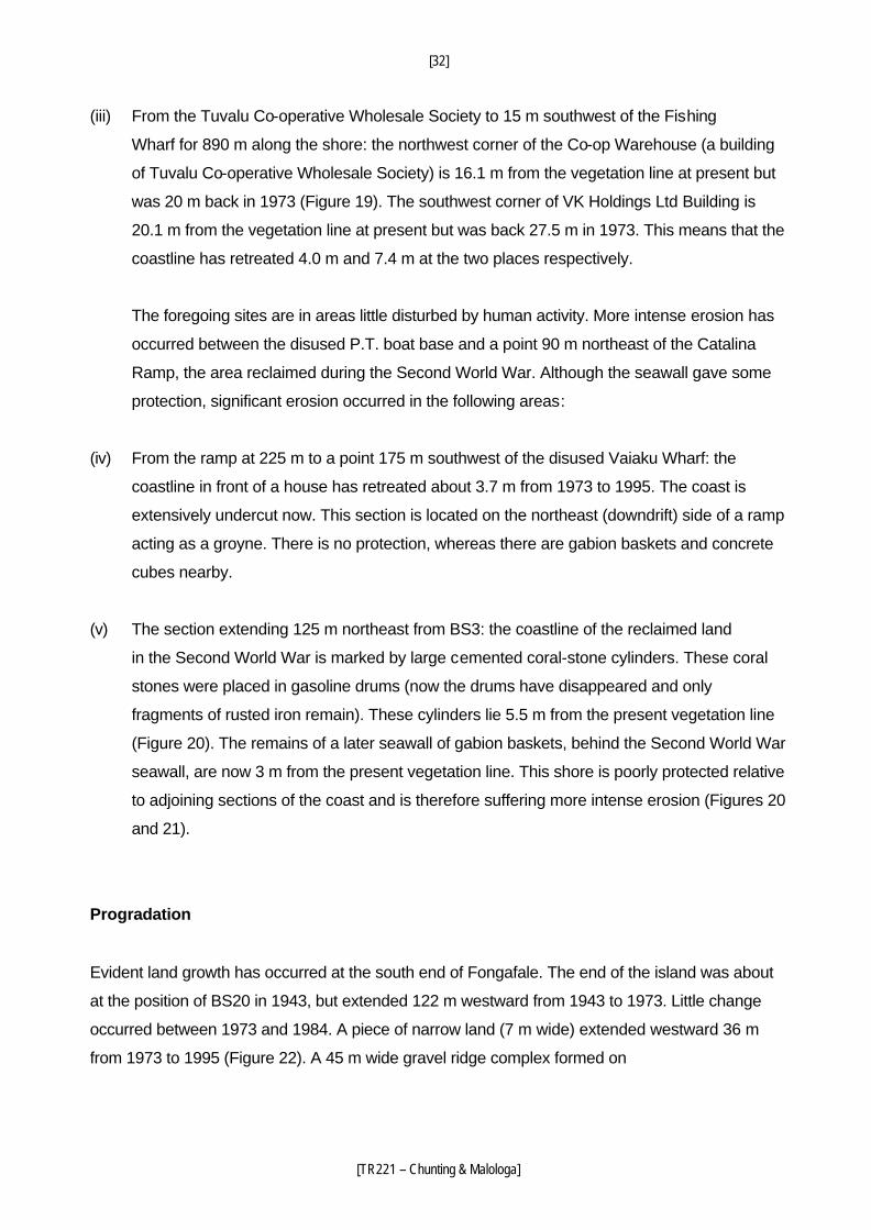
(iii) From the Tuvalu Co-operative Wholesale Society to 15 m southwest of the Fishing
Wharf for 890 m along the shore: the northwest corner of the Co-op Warehouse (a building
of Tuvalu Co-operative Wholesale Society) is 16.1 m from the vegetation line at present but
was 20 m back in 1973 (Figure 19). The southwest corner of VK Holdings Ltd Building is
20.1 m from the vegetation line at present but was back 27.5 m in 1973. This means that the
coastline has retreated 4.0 m and 7.4 m at the two places respectively.
The foregoing sites are in areas little disturbed by human activity. More intense erosion has
occurred between the disused P.T. boat base and a point 90 m northeast of the Catalina
Ramp, the area reclaimed during the Second World War. Although the seawall gave some
protection, significant erosion occurred in the following areas:
(iv) From the ramp at 225 m to a point 175 m southwest of the disused Vaiaku Wharf: the
coastline in front of a house has retreated about 3.7 m from 1973 to 1995. The coast is
extensively undercut now. This section is located on the northeast (downdrift) side of a ramp
acting as a groyne. There is no protection, whereas there are gabion baskets and concrete
cubes nearby.
(v) The section extending 125 m northeast from BS3: the coastline of the reclaimed land
in the Second World War is marked by large cemented coral-stone cylinders. These coral
stones were placed in gasoline drums (now the drums have disappeared and only
fragments of rusted iron remain). These cylinders lie 5.5 m from the present vegetation line
(Figure 20). The remains of a later seawall of gabion baskets, behind the Second World War
seawall, are now 3 m from the present vegetation line. This shore is poorly protected relative
to adjoining sections of the coast and is therefore suffering more intense erosion (Figures 20
and 21).
Progradation
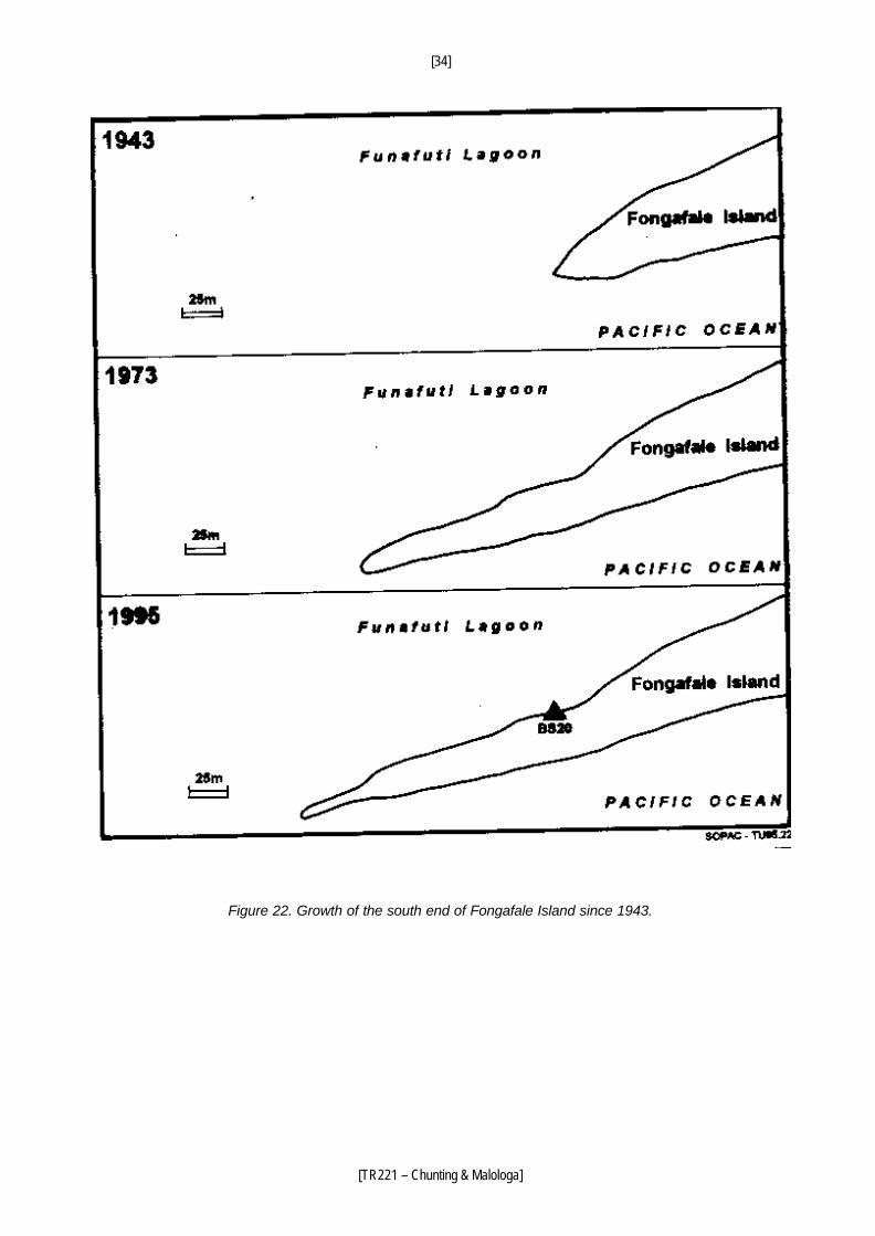
Evident land growth has occurred at the south end of Fongafale. The end of the island was about
at the position of BS20 in 1943, but extended 122 m westward from 1943 to 1973. Little change
occurred between 1973 and 1984. A piece of narrow land (7 m wide) extended westward 36 m
from 1973 to 1995 (Figure 22). A 45 m wide gravel ridge complex formed on
[33]
[TR221 – Chunting & Malologa]
Figure 20. Coastal erosion to northeast of BS3. The shoreline of the reclaimed land in World War II is shown by the cemented coral stone cylinders, which were put in gasoline drums. The remains of a gabion basket seawall lie between the eroded coast and the cylinders.
Figure 21. Coastal erosion to northeast of BS3.
[34]
[TR221 – Chunting & Malologa]
Figure 22. Growth of the south end of Fongafale Island since 1943.
[35]
[TR221 – Chunting & Malologa]
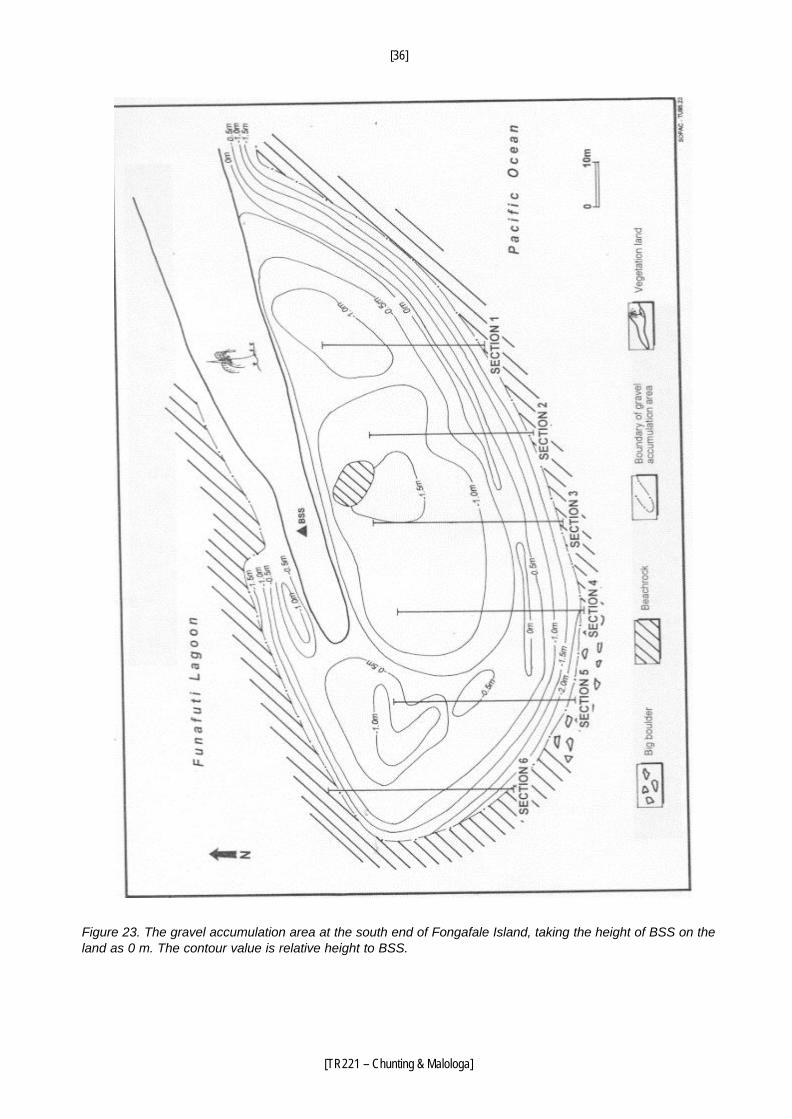
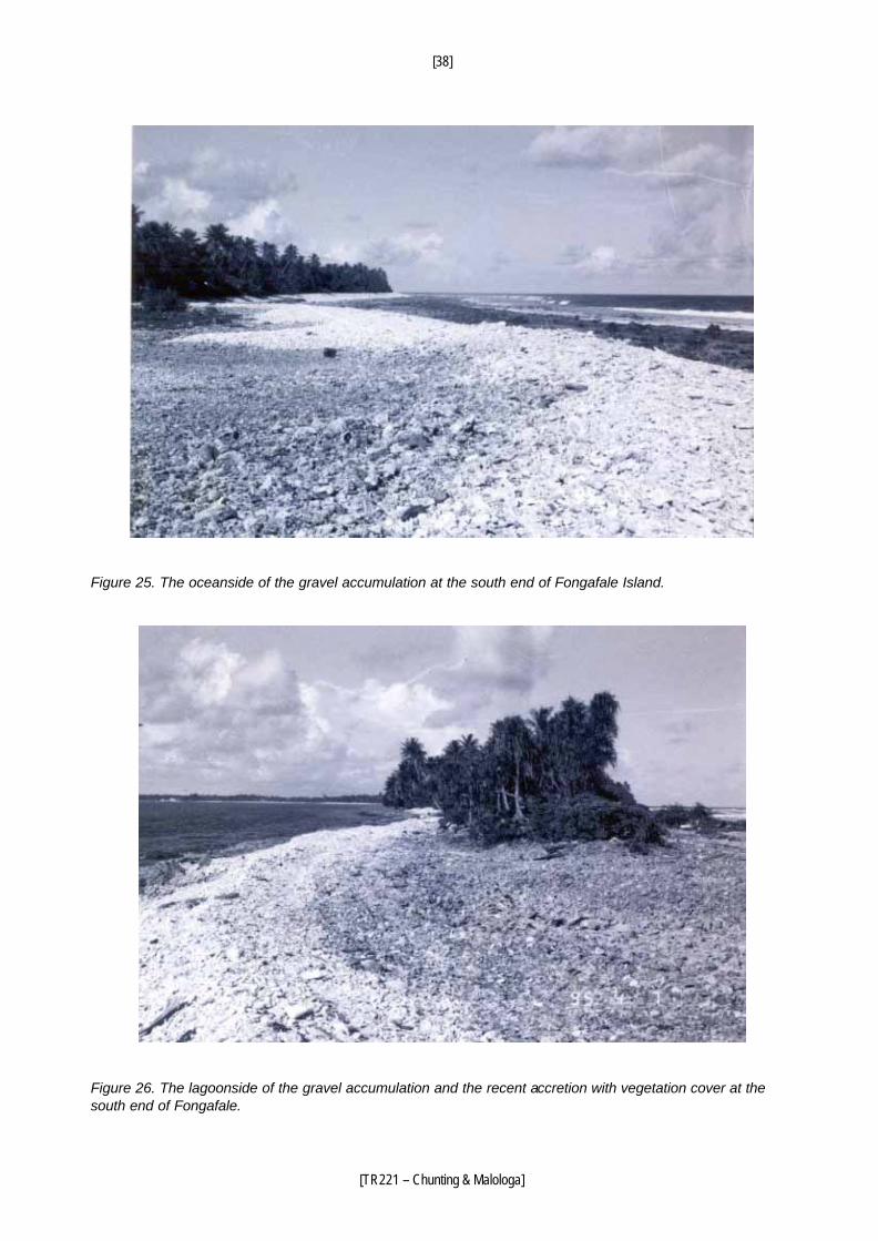
the ocean side, as result of southwestward longshore transport on the outer (ocean side) coast
(Figures 23-25). A 10 m wide gravel beach accumulated on the lagoon side (Figures 23 and 26).
Some gravel was transported into the lagoon and then moved northeast by longshore currents to
be deposited on beachrock.
FORMATION AND EVOLUTION OF FONGAFALE ISLAND
There was a lake with surrounding mangrove swamp in the widest part of Fongafale before 1942.
Most of the lake was shown by the aerial photographs taken in June 1941 (Figure 2). The
northwest part was filled up during the Second World War for building the runway, but the rest still
exists (Figure 5). The lake, not including surrounding mangroves, was drawn on the 1:2500
topographic map published in 1979 by British Government's Overseas Development
Administration.
Before discussing the evolution of Fongafale, we examine Funafara, Telele and adjacent islands in
southern Funafuti Atoll (Figure 27). Mateika, Luamotu, Mafola and Funafara are distributed along a
north-south line and Telele, Motusanapa and Motuloa extend to the southwest. All of these islands
are connected at low tide. The south end of Funafara and the north end of Telele are growing along
four extending headlands (Figure 27). Gravel accumulates on the ocean side beaches. The two
islands are connected by a boulder bar at low tide. A small island has already emerged. Sand
beaches are present on the lagoon side. A sand spit extends southwest from the southwest
headland of Funafara and then turns southeast. At low tide, it almost connects with the sand spit
extending from the northwest end of Telele. There is an almost closed water area surrounded by
land and beach at low tide (Figure. 27). In the future Funafara and Telele Islands are expected to
connect and a lake will form. The north end of Funafara and both (north and south) ends of
Mateika, Luamotu and Mafora are growing and may eventually connect. Telele may similarly
connect with the other southwest islands. Ultimately this will produce a long, narrow, V-shaped
island, similar to Fongafale at present. So, it can be said that today's Fongafale is tomorrow's
Funafara, Telele and other related islands.
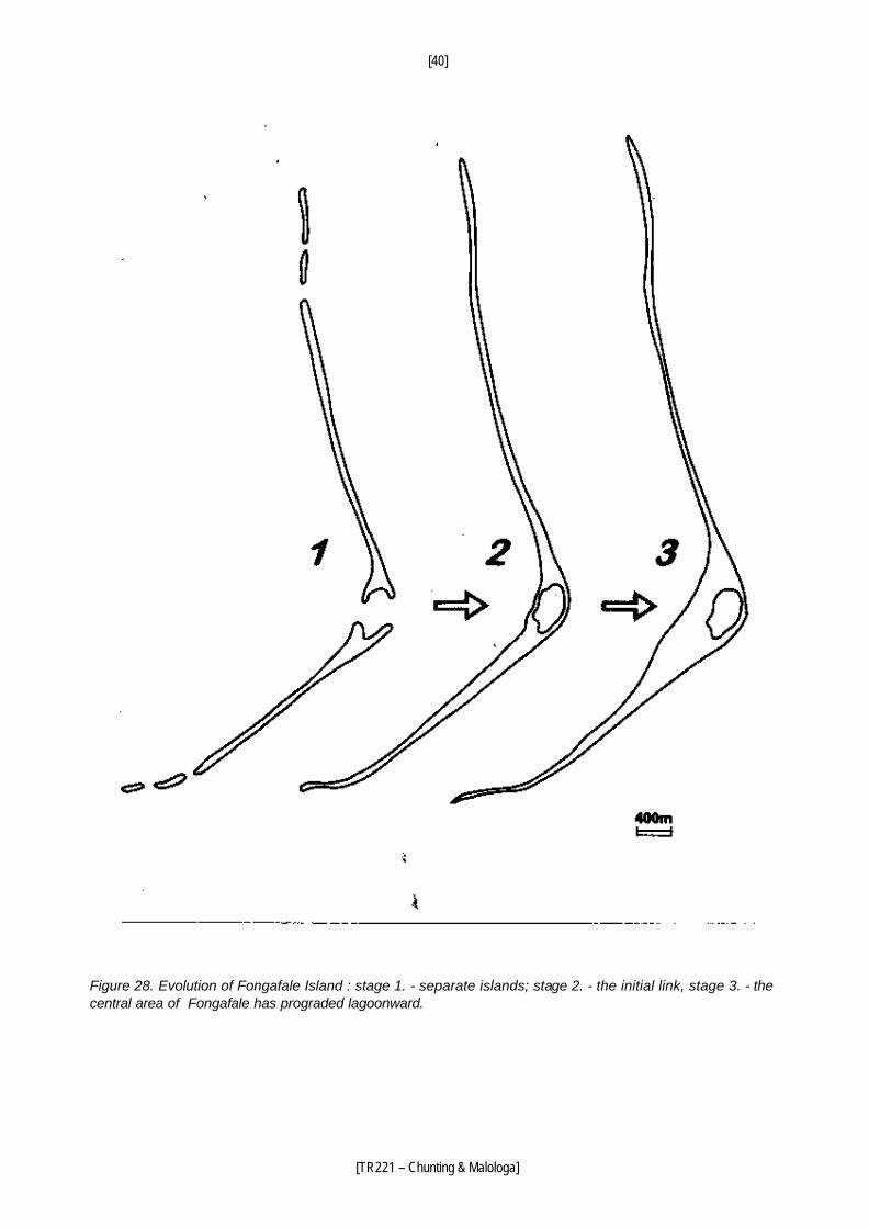
In the past, Fongafale may have been six small islands, three of which were arranged along the
northwest and three along the southwest. Among them, the two central islands had two opposing
headlands respectively, which gradually grew together, leaving the lake (Figure 28). At about the
same time, the remaining islands also became connected to form the broad V-shaped narrow
[36]
[TR221 – Chunting & Malologa]
Figure 23. The gravel accumulation area at the south end of Fongafale Island, taking the height of BSS on the land as 0 m. The contour value is relative height to BSS.
[37]
[TR221 – Chunting & Malologa]
Figure 24. Cross sections in the gravel accumulation area at the south end of Fongafale Island. For location of the sections, see Figure 23.
[38]
[TR221 – Chunting & Malologa]
Figure 25. The oceanside of the gravel accumulation at the south end of Fongafale Island.
Figure 26. The lagoonside of the gravel accumulation and the recent accretion with vegetation cover at the south end of Fongafale.
[39]
[TR221 – Chunting & Malologa]
Figure 27. The south end of Funafara Island and the north end of Telele Island, showing the merging trend.
[40]
[TR221 – Chunting & Malologa]
Figure 28. Evolution of Fongafale Island : stage 1. - separate islands; stage 2. - the initial link, stage 3. - the central area of Fongafale has prograded lagoonward.
[41]
[TR221 – Chunting & Malologa]
island of Fongafale. The bends of the present island, such as close to BS19, and 650 m south of the
High School, and the areas of sand accumulation, such as 330 m northeast of the south end of
Fongafale and the High School, may be the connecting points between former islands. After
formation of the two long northwest and southwest extending arms, more sand was transported to
the central area of Fongafale and accumulated there, forming a long sand beach. The progradation
on the lagoon side of the central area of Fongafale was relatively fast. The lagoon coasts of the two
arms have been relatively stable. On the ocean side, coastal progradation occurred after a very
strong tropical storm, Cyclone Bebe, in 1972 (Maragos et al., 1973; Baines and McLean, 1976).
The natural central depressions of Fongafale are about in the middle of each arm, between the
ridge complex on the ocean side and the ridge complex on the lagoon side. Both ridge complexes
are composed primarily of gravel (much coarser on the ocean side). In the central area of
Fongafale, the distance between the mangrove (the margin of the lake) and the ocean side
vegetation line is only 6-18 m. But the distance between the mangrove surrounding the lake and
the vegetation line on the lagoon side was more than 240 m in 1941.
The beachrock along the south and north arms is located at the present beach and adjacent
nearshore, beside the present vegetation line. This means that the present shore is close to the
shoreline before the sediments in the beachrock became cemented. Because the central area has
no exposed beachrock (except at the north end), the rock is assumed to be buried by beach
accretion, far from the present shoreline.
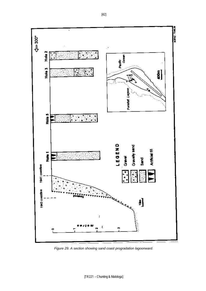
Five shallow boreholes (1.95-2.40 m deep) were made with a hand auger (Figure 29). All of the
sediments are sand, including a little gravelly sand. The easternmost hole is 168 m from the
present shore or about 148 m from the shoreline in 1941 (Figure 29). It shows that sand
accumulation in the central area of Fongafale has a long history.
COASTAL MANAGEMENT AND SAND BEACH RECOVERY
The coastal sedimentation on the lagoon side and evolution of Fongafale show that since the
island formed gravel has accumulated on the beach along the two arms, with only limited sand,
whereas sand has accumulated preferentially in the central area.
[42]
[TR221 – Chunting & Malologa]
Figure 29. A section showing sand coast progradation lagoonward.
[43]
[TR221 – Chunting & Malologa]
The seawall has helped to protect the coast, but it is aesthetically unpleasing and prevents the
sand beach from recovering (Figures 30, 31 and 32), hindering the development of tourism.
Coastal management and coastal protection efforts should therefore aim to recover the natural
scene if possible.
A sand beach was present in the central area of Fongafale from the time of its formation until the
Second World War. This beach disappeared because of the land reclamation in the War and now
most places are covered by relict boulders and seawall. The central area has potential for sand
beach recovery. This is the area of convergence between the southwest and northwest arms,
receiving sand from both directions. Moreover, sand is easily transported to the beach by
shoreward currents because there is a relatively wide zone of thick sand on the reef flat.
There is a shortage of sand in Funafuti Atoll. Moreover, if sand is directly replenished, the
recovered sand would be removed by waves, because the sea-bed slope is too steep to keep
sand (Figures 20, 30, 31 and 32). It is therefore necessary to seek another way.
Half a century has passed since the Second World War. Fortunately the sandy beach has
recovered to a limited extent. The gradients of the beach and adjacent nearshore in other places
are still too steep to stabilise a sand beach. Some parts of the long channel borrow pit have not yet
filled up completely (Figures 33 and 34).
The elevation of the vegetation line on the sand beach at section 95058 is 1.60 m (Appendix 1;
Figure 34). The elevation of a mark (BS2-1) at the southwest corner of the top platform of the jetty
close to Vaiaku Lagi Hotel is 1.65 m. So 1.65 m elevation can be taken as the common elevation of
the vegetation line near the hotel. The contours in Figure 33 are calculated on this assumption.
In order to speed up the sand beach recovery, gravel can be placed on the sea bed at a slope
close to the natural gradient of the sandy beach, and on which sand can naturally accumulate. A
beach nourishment area is proposed around Vaiaku Lagi Hotel, from 55 m southwest of the jetty
close to the hotel, to 60 m northeast of BS3 (257 m total length). The sea bed and beach surface
of section 95058 is stable and all of its surface sediments are sand. The sea bed and beach
surface of section 95059 is rather stable with a 3.5 m wide band of cobbles and pebbles close to
the vegetation line. If the beach and adjacent nearshore surface are made higher, to approach the
elevation and slope of section 95059, sand will naturally accumulate to form a sand beach.
[44]
[TR221 – Chunting & Malologa]
Figure 30. The concrete seawall and boulders on the beach in front of Vaiaku Lagi Hotel.
Figure 31. The cemented boulder seawall and boulders on the beach in front of Vaiaku Lagi Hotel.
[45]
[TR221 – Chunting & Malologa]
Figure 32. Piled concrete cubes forming seawall in the southwest of Catalina Ramp.
The gravel should be built up to a gradient equivalent to section 95059 out to a distance about
60 m from the vegetation line, with a steep slope between 60 m and 70 m.
To change the elevation and gradient, roughly 11 254 m3 of gravel is needed (Figure 34; Appendix
2). Some sand needs to be replenished to fill the voids between the gravel. Gravel accumulated on
the south end of Fongafale can be used for replenishment. This would be economical. However,
there are only 3582 m3 gravel that can be used (Appendix 3). This leaves a shortage of 7672 m3 of
gravel.
[46]
[TR221 – Chunting & Malologa]
Figure 33. Bathymetry near Vaiaku Lagi Hotel. Elevations relative to BS2-1 at 1.65 m on the jetty close to the hotel. This elevation represents the general height of the vegetation line near the hotel.
[47]
[TR221 – Chunting & Malologa]
Figure 34. Beach and coral flat sections in the central area of Fongafale. The broken line represents the beach replenishment limit.
[48]
[TR221 – Chunting & Malologa]
Figure 35. Accumulation of gravel without vegetation cover at the south end of Funangongo Island.
In recent years gravel has accumulated at both ends of the islands south of Fongafale, such as
Futato, Funangongo and Funamanu (Figure 35). Removing the gravel would not produce a
significant environmental impact, except at the southwest end of Funamanu. Taking this gravel
would be more expensive than taking from the southwest end of Fongafale. The jetty close to
Vaiaku Lagi Hotel (at the southwest corner of the hotel) should be demolished or changed to a
pier-type wharf. Otherwise erosion will continue on the downdrift side of the jetty, just in front of the
hotel.
[49]
[TR221 – Chunting & Malologa]
CONCLUSIONS
1. The reef flat is classified into two types and divided into three provinces. The south
province and north province belong to Type I and the central province belongs to Type II,
showing good symmetry.
2. The beach is classified into two types and divided into three regions. The south and
north regions belong to Type 1 and the central region to Type 2, showing good symmetry.
This division coincides exactly with the geographical division of the island.
3. The good symmetries of division of reef flat provinces and beach regions are
controlled by longshore currents, which in turn are closely related to the outline of Fongafale.
4. The longshore currents transport sand from the northwest and southwest towards the
central area, producing a good sand beach before World War II. Because of human activity
initiated during the war, the beach in the central area is now mostly covered by boulders and
concrete cubes. However this area has good potential for sand beach recovery.
5. Fongafale was mainly formed by two islands growing together. After the
connection was established, coastal progradation proceeded rapidly on the lagoon side in
the central area.
6. Beach recovery could be promoted by replenishing gravel on the beach and nearshore
surface near Vaiaku Lagi Hotel, to form a slope on which sand would accumulate naturally.
7. Construction of seawalls should be avoided, as they promote beach erosion.
8. In recent years gravel has accumulated at the south end of Fongafale and the
ends of the other adjacent islands. These deposits of gravel could be used to nourish the
beaches.
[50]
[TR221 – Chunting & Malologa]
REFERENCES
Baines G. B. K. and McLean R. F., 1976. Sequential studies of hurricane deposit evolution at Funafuti atoll. Marine Geology, 21: M1-M8.
Carter R., 1985. Funafuti sea and swell observations. CCOP/SOPAC Technical Report 54, 3 pp.
plus appendices. Carter R., 1986a. Funafuti sea and swell observation, Latitude 8º 31' S Longitude 179º 12' 3" E.
CCOP/ SOPAC Technical Report 56, 4 pp. plus appendices. Carter R., 1986b. Wind and sea analysis, Funafuti lagoon, Tuvalu. CCOP/SOPAC Technical
Report 58, 9 pp. plus appendices. David T. W. E., 1904. The Geology of Funafuti. In: The Atoll of Funafuti. Royal Society of London,
61-124. Fawcett and Partners, 1982. Report on Prevention of Coastal Erosion. 76pp. Gillie R. D. and Harper J. R., 1992. Beach profile survey data 1984 to 1991, Fongafale, Funafuti,
Tuvalu. SOPAC Preliminary Report 50, 15 pp. plus appendices. Howorth R., 1986. Report on visit to Tuvalu, May 19-23, 1986 to resurvey beach profiles on lagoon
side of Fongafale. CCOP/SOPAC Technical Report 68, 3 pp. plus appendices. Howorth R., 1991. Beach profile monitoring programs in Kiribati and Tuvalu. SOPAC Technical
Bulletin 7, 201. Howorth R. and Radke B., 1991. Investigation of historical shoreline change: Betio, Tarawa Atoll,
Kiribati and Fongafale, Funafuti , Tuvalu. SOPAC Technical Bulletin 7, 91-98. Howorth R. and Woodward P., 1994. Tuvalu in-country seminar on beach monitoring, 24-28
January 1994. SOPAC Training Report 62, 8pp. plus appendices. Maragos J. E., Baines G. B. R. and Beveridge P. J., 1973. Tropical Cyclone Bebe creates a new
land formation on Funafuti atoll. Science 181: 1161-1164. Radke B. M., 1985. Bathymetry and beach profiling, Funafuti, Tuvalu, 24 September- 19 October
1984. CCOP/SOPAC Cruise Report 106, 18 pp. plus appendices. Rearic D. M., 1991. Mapping survey and baseline study of coastal erosion on the islands of Tuvalu,
22 August to 9 September 1991. SOPAC Preliminary Report 38, 12 pp. Richmond B. and Howorth R., 1989. Extended summary of techniques used and data collected
during coastal mapping workshop Funafuti, Tuvalu, June 1987. CCOP/SOPAC Technical Report 89, 86 pp.
Volume of gravel needed to replenish the beach and nearshore near Vaiaku Lagi Hotel
The area is divided into 7 blocks. The volume of each block is the product of the cross sectional and the width alongshore. The area of each section is computed as the sum of the areas of several trapezoids and/or triangles, calculated from right to left (Figure 34). These block volumes are given below (from northeast to southwest) (Figure 33). Block 2 Area of section 2 0.9x7.5/2+0.9x42.5/2 = 22.5 (m2) Width of block 2 70 m (60 m to northeast and 10m to southwest from the section) Volume of block 2 22.5x70 = 1575 (m3)
Block 1
Area of section 1 0.8x3/2+(0.6+0.8)x39/2+0.6x10/2 = 31.5 (m2) Width of block 1 20 m (10 m to northeast and 10 m to southwest) Volume of block 1 31.5x20 = 630 (m3) Block 3 Area of section 3 1x16/2+0.7x42/2+0.5x10/2 = 25.2 (m2) Width of block 3 18 m (9 m to northeast and 9m to southwest) Volume of block 3 25.2 x18 = 454 (m3) Block 4 Area of section 4 0.8x2/2+(0.7+0.8)x1/2+(0.8+0.7)x6.5/2+(0.5+0.8)x8/2+(0.6+0.5)x2.5/2 +(0.9+0.6x13/2+(0.6+0.9)x15/2+0.6x10/2 = 37.0 (m2) Width of block 4 23 m ( 9.5 m to northeast and 13.5 m to southwest) Volume of block 4 37.0x23 = 851 (m3) Block 8 Area of section 8 1.0x2/2+(1.2+1.0)x2/2+(0.7+1.2)x14/2+(1.2+0.7)x11/2+(0.8+1.2)x26/2 +0.8x10/2+(10+26)x0.4/2 = 64.15 (m2) Width of block 8 26 m (14 to northeast and 12 to southwest) Volume of block 8 64.15x26 = 1668 (m3) Block 5 Area of section 5 (0.1+0.8)x14/2+(0.2+0.1)x2/2+(1.2+0.2)x7/2+(1.2+1.2)x8/2 +(0.7+1.2)x25/2+0.7x10/2+(15+25)x0.4/2 = 56.35 (m2) Width of block 5 27.5 (m) (12 m to northeast and 15.5 m to southwest Volume of block 5 56.35x27.5 = 1550 (m3) Block 6 Area of section 6 (0.6+0.8)x9/2+(0.5+0.6)x5/2+(1.0+0.5)x8/2+(1.2+1.0)x5/2+(0.7+1.2)x29/2 +0.7x10/2+0.6x39/2 = 63.3 (m2) Width of block 6 25.5 m (15.5 m to northeast and 10 m to southwest) Volume of block 6 63.3x25.5 = 1614 (m3) Block 7 Area of section 7 0.7x4/2+(0.6+0.7)x6/2+(1.3+0.6)x9/2+(0.7+1.3)x33/2+0.7x10/2+(15+43)x0.4/2=61.95 (m2) Width of block 7 47.0 m (12.5 m to northeast and 34.5 m to southwest Volume of block 7 61.95x47 = 2912 (m3) Total volume of gravel that need to be replenish 1575+630+454+851+1668+1550+1614+2912 = 11254 (m3)
[54]
[TR221 – Chunting & Malologa]
APPENDIX III
Volume of gravel at the southwest end of Fongafale Island that could be exploited
The gravel deposits is divided into seven blocks. The volume of each block is the product of the cross-sectional area and the width of the block alongshore (20 m). The section is computed as the sum of the areas of several trapezoids and/or triangles, calculated from left to right in each section (Figure 24). 1. Block 1
Area of section 1 (0.8+1.6)x10/2+1.6x15/2 = 24.2 (m2) Volume of block 1 24.2x20 = 484 (m3)
2. Block 2 Area of section 2 (0.4+0.6)x17/2+(0.6+1.6)x5/2+1.6x9/2=21.7 (m2) Volume of block 2 21.7x20 = 434 (m3)
3. Block 3 Area of section 3 (0.4+1.8)x25/2+1.8x7/2 = 33.8 (m2) Volume of block 3 33.8x20 = 676 (m3)
4. Block 4 Area of section 4 0.6x20/2+(0.6+1.8)x7/2+1.8x9/2 = 22.5 (m2) Volume of block 4 22.5x20 = 450 (m3)
5. Block 5 Area of section 5 (0.4+1.2)x22/2+(1.2+1.8)x4/2+1.8x9/2 = 31.7 (m2) Volume of block 5 31.7x20 = 634 (m3)
6. Block 6 Area of section 6 (0.8+1.8)x20/2+1.8x7.4/2 = 32.7 (m2) Volume of block 6 32.7x20 = 654 (m3)
7. Block 7 Area of section 7 1x4/2+(1+0.8)x10/2+(0.8+1.2)x7/2+1.2x13.4/2 = 26.0 (m2) Volume of block 7 26.0x20 = 520 (m3)