Coastal Systems and Landscapes 1. Coasts as natural systems Key Concept / Key Question Tick when confident Why is the coast an example of an open system? What is an input into a coastal system? What is an output into a coastal system? What is the energy in a coastal system? What are flows and transfers? What is positive feedback in a coastal system? What is negative feedback in a coastal system? What does the term dynamic equilibrium mean? How does the coastal system link to other natural systems?
Transcript
Coastal Systems and Landscapes
1. Coasts as natural systems
Key Concept / Key Question Tick when confident
Why is the coast an example of an open system?
What is an input into a coastal system?
What is an output into a coastal system?
What is the energy in a coastal system?
What are flows and transfers?
What is positive feedback in a coastal system?
What is negative feedback in a coastal system?
What does the term dynamic equilibrium mean?
How does the coastal system link to other natural systems?
The coastal system: The narrow strip where the sea and land interact is shaped and influenced
by both natural and human variables within a powerful system. The action of waves, tides and currents
provides an input of energy which is then used through the processes of erosion, weathering,
transportation and deposition to produce the morphology of the coastal zone above and below the
waves. The coastal system is driven by wave energy within the nearshore (breaker zone) and foreshore
(intertidal) zones. Figure 1 shows how the components of the system are related and interact. The
processes within the system and the appearance of the coastline will be controlled by a number of
physical variables and possibly influenced by human activity.
The coast is an example of an open system. This means that it has inputs that originate from outside the
system (such as sediment carried into the coastal zone by rivers) and outputs to other natural systems
(such as eroded rock material being transported offshore to the ocean).
As an open system, the coast has important links with other natural systems such as the atmosphere
(consider the importance of wind in generating waves), tectonics, ecosystems and oceanic systems.
These natural systems are linked together by flows of energy and by the transfer of material.
It is useful to apply systems terminology to help us understand the connections between processes and
landforms. A really clear example of the application of systems concepts to the coast is the sediment
cell. There are eleven major sediment cells in England and Wales, which form the basis of coastal
management Here, there are clear inputs of sediment (eg. longshore drift), stores (eg. beaches and spits)
and outputs (eg. the transfer to the deep ocean). This is probably the most straight forward way of
understanding the coast using systems terminology.
Key Terminology:
Systems Term Definition Coastal Examples
Input Material or energy moving into the
system from outside.
Precipitation, wind.
Output Material or energy moving from the
system to the outside.
Ocean currents, rip tides, sediment transfer,
evaporation.
Energy Power or driving force.
Energy associated with flowing water, the effects of
gravity on cliffs and moving air (wind energy
transferred to wave energy).
Stores/components The individual elements or parts of
a system.
Beach, sand dunes, nearshore sediment
Flows/transfers The links or relationships between
the components.
Wind-blown sand, mass movement processes,
longshore drift.
Positive feedback Where a flow / transfer leads to
increase or growth.
Coastal management can inadvertently lead to an
increase in erosion elsewhere along the coast.
Groynes trap sediment, depriving area further down
drift of beach replenishment and this can worsen
erosion rates.
Negative feedback Where a flow / transfer leads to
decrease or decline.
When the rate of weathering and mass movement
exceeds the rate of cliff foot erosion a scree slope is
formed. Over time, this apron of material extends up
the cliff face protecting the cliff from subaerial
processes. This leads to a reduction in the
effectiveness of weathering and mass movement.
Dynamic equilibrium This represents a state of balance
within a constantly changing
system.
Constructive waves build up a beach, making it
steeper. This encourages the formation of destructive
waves that plunge rather than surge. Redistribution of
sediment offshore by destructive waves reduces the
beach gradient which, in turn, encourages the waves
to become more constructive. This is a state of
constant dynamic-equilibrium between the type of
wave and the angle of the beach.
Coastal Systems and Landscapes
2. Systems and processes
Key Concept / Key Question Tick when
confident
How is wind a source of energy at the coast?
What is the fetch of a wave?
What are waves and how are they formed?
What do the terms swash and backwash mean?
What are the characteristics of destructive and constructive waves
What is wave refraction and how does it occur?
What are longshore, rip and upwelling currents?
What are the causes of tides?
What are neap tides?
What are spring tides?
What are tidal or storm surges?
What are the differences between high energy and low energy coasts?
What are sediment sources, cells and budgets?
What is sub-aerial weathering (biological, mechanical and chemical)?
How do the different types of marine erosion occur (hydraulic action, wave
quarrying, abrasion, attrition, solution).
How is the rate of coastal erosion affected by wave steepness, fetch, sea
depth, coastal configuration, beach presence, geology and human activity.
What is marine transportation and can you explain the different types
(traction, saltation, suspension, solution)?
What is aeolian deposition and why does it occur?
What are the different types of mass movement and how do they occur?
(landslides, rock falls, mudflows, rotational slip, soil creep)
Systems and Processes
Waves are caused by the surface of the sea exerting frictional drag on the lowest layer of the wind.
Higher layers of the wind then move faster over the lower levels and fall forward, pushing down on the
sea surface, creating a wave. As the wind blows on the back of the small ripple, the wave grows. In the
open sea there is no actual movement of water, just a movement of energy. An imaginary particle would
move in a clockwise direction between wave crest, trough, then back to the crest of the wave, but would
not move forward in the ocean; these are called oscillation waves. The orbit of the particle varies from
circular to elliptical; the base of the orbit is called the wave base (Figure 2). The height of the wave is an
indication of energy and depends on the fetch (the distance over which the wind blows), the strength
of the wind, duration of the wind, and sea depth. Strong winds will create steep waves which, when the
winds ease, will decrease in height and increase in wavelength. These waves are called swell. Swell
waves effect the Atlantic coasts of Britain even in the quieter summer months. Wave refraction occurs
where the undersea topography causes the wave fronts to slow, bend and aim to break parallel to shore.
This effect is most often seen in a headland and bay coastline. Wave energy tends to be concentrated on
the headlands hence more erosion, with lower energy levels occurring within the bays and deposition
occurring. If the waves break at an angle within the bays, then longshore drift occurs.
Constructive Destructive
Long wavelength
Low in height
Strong swash pushes sediment up the beach.
Backwash soaks into beach on return. Sediment
not pulled back
Lower energy waves , commonly swell waves.
6–10/minute
Most effective over a gentle shelving sea bed.
Short wave length Steep wave faces and high wave height Wave crashes downwards into the trough of the wave with little swash Backwash is very strong and drags material back down the beach Backwash interferes with swash of next wave
Higher energy waves generate
Localised storm conditions
11–15/minute
Tides:
The ocean’s tides are controlled by the gravitational pull of the Moon, and to a lesser extent the Sun. The
Moon pulls the water in the ocean towards it, creating a bulge of water; a high tide. The Moon not only
pulls the water but also pulls the Earth towards it, this creates a second bulge of water and the second
high tide on the other side of the Earth. Twice a month the Earth, Moon and Sun are aligned: this puts
an extra gravitational pull on the tidal bulge, to produce an extra high tide called a spring tide. When
the Sun and Moon are at right angles to each other, neap tides occur, when the tidal range is lowest.
When the Earth, sun and moon form a right angle, their gravitational pull interfere with one another and this us when neap tides occur, giving the lowest high tide and highest low tide (lowest tidal range).
Sediment Cells:
There are 11 sediment cells on the England and Wales coastline running around Britain from St Abb’s Head of the north east Scottish Border to the Solway Firth in the west.
A sediment cell (also known as a littoral cell) is defined as a length of coastline that is relatively self-contained
as far as the movement of sand or shingle is concerned, and where interruption to such movement should
not have a significant effect on adjacent sediment cells.
Each major sediment cell is divided into a number of sub-cells.
Coastal sediment budgets:
For a sandy beach or muddy shoreline to come from somewhere and the combination of wave, current
and tide action to be such that the material remains there. This introduces the concept of the coastal
sediment budget. The coastal sediment budget is best thought of as being similar to a bank account, and
is defined as the difference between sediment being added and removed from the coastal system, within
a single sediment cell.
The processes of coastal erosion control the level of the deficit as they remove material from the
shoreline, and if more sediment is removed than added then the coastline will recede. The sediment
budget can alos be used to identify sources that deliver sediment to the cell and to the sites where
sediment is stored, or sediment sinks. Therefore, calculating the sediment budget for a cell requires
identification of all the sedminent added and removed each year. Calculating budgets is extremeley
difficult and most efforts rely on complex models and estimations.
Coastal Processes:
Marine Erosion: This is the wearing away of the land by moving agents such as the sea (in this case),
rivers, wind, glaciers etc. There are several types operating at the coast including:
Hydraulic action - this is where water from a wave enters cracks in the cliff face, compresses air within
the cracks and causes pressure to be exerted on the surrounding rock, which weakens and breaks off.
Corrosion - weak acids within the sea can react with certain rocks types at the coast and cause them to
dissolve slowly, this is particularly important for Limestone and chalk coastlines.
Abrasion - This is where rocks picked up and carried within waves are thrown onto the beach and cliffs,
damaging them.
Attrition - This is where rocks and pebbles carried within the sea hit against one another and break
down into smaller particles.
Wave quarrying – A breaking wave traps air as it hits a cliff face. The force of water compresses this
air into any gap in the rock face, creating enormous pressure within the fissure or joint. As the water
pulls back, there is an explosive effect of the air under pressure being released. The overall effect of this
is to weaken the cliff face. This is sometime referred to as cavitation.
Factors Affecting the Rate of Erosion:
The biggest factor affecting coastal erosion is the strength of the waves breaking along the coastline. A
wave’s strength is controlled by its fetch and the wind speed. Longer fetches & stronger winds create
bigger, more powerful waves that have more erosive power. As waves approach a coastline they lose
energy though because friction with the seabed increases. This means that the bathymetry (the
underwater elevation) of the ocean or sea bed also impacts the strength of waves.
Coastal configuration can influence the rate of erosion. For example headlands attract energy through
wave refraction.
Certain landforms further reduce wave’s erosive power. Beaches increase the distance a wave travels
before it reaches the coastline’s cliffs and so reduces its energy. Headlands refract waves around them,
reducing their erosive power at one location while increasing it at another.
The sea depth can also affect the rate of erosion. A steeply shelving sea bed will create higher and
steeper waves.
Weathering also plays a role in the rate of erosion by creating weaknesses in rocks that are exploited
by the processes of erosion. Freeze-thaw weathering, for example, creates cracks in rocks, increasing
the rock’s susceptibility to hydraulic action.
As always, humans have an impact on coastal erosion. Human activities have a variety of complex effects
on coastal erosion but most commonly the activities increase the strength of waves. One activity,
dredging, is commonly carried out to improve shipping capacities but it reduces the amount of energy
dissipated from incoming waves and so increases erosion.
Lithology
Lithology refers to the physical properties of a rock such as its resistance to erosion. The lithology of a
coastline affects how quickly it’s eroded. Hard rocks (e.g., Gabbro) are resistant to weathering & erosion
so a coastline made of granite (e.g., Land’s End) will change slowly. Soft rocks (e.g., Limestone) are more
susceptible to weathering & erosion so a coastline made of chalk (e.g., Dorset) will change relatively
quickly.
If you looked down on a coastline from above and saw the geology of the area, you’d be able to see that
the rock type changes as you approach the coastline and that the different rocks are arranged in bands.
The angle these bands make with the coastline makes it either a concordant or discordant coastline.
Concordant coasts have alternating layers of hard and soft rock that run parallel to the coast. The hard
rock acts as a protective barrier to the softer rock behind it preventing erosion. If the hard rock is
breached though, the softer rock is exposed and a cove can form (e.g., Lulworth Cove).
On a discordant coastline, alternating layers of hard and soft rock are perpendicular to the coast.
Because the soft rock is exposed, it is eroded faster than the hard rock. This differential erosion creates
Chemical Weathering: Corrosion is technically a form of weathering and not erosion. Processes such
as hydrolysis and oxidation can weather away rocks. Hydrolysis involves the splitting of minerals due
to their reactivity with water. Oxidation is, basically, rusting. Elements such as iron are susceptible to
oxidation and can be found within minerals on coastlines. Hydration is included here as it makes rocks
more susceptible to further chemical weathering, although it involves the addition of water to minerals
in the rock. This causes the rock to expand and disintegrate. Carbonation occurs where Carbon Dioxide
dissolved in rainwater makes a weak carbonic acid. This reacts with calcium carbonate in rocks like
limestone and chalk and dissolves easily in water. Carbonation is more effective in locations with cooler
temperatures as this increases the amount of carbon dioxide that is dissolved in the water. Acid rain
associated with industry and the burning of fossil fuels can make seawater mildly acidic and can react
with rocks to weather them at faster rates.
Mass Movement
Mass movement can be defined as the large scale movement of weathered material in response to
gravity. Essentially, it’s when a cliff or other structure that is not horizontally orientated has been
weathered to the point at which it starts to collapse. There’s five types of mass movement: rockfall, soil
creep, landslides, mudflow and slumping.
Rockfalls: Freeze thaw weathering on a cliff breaks the rocks up into smaller pieces which can then
free fall. This occurs commonly on cliffs with lots of joints as the joints make it easier to break up the
rock. If the cliff is undercut by the sea, it can lose some of its stability, increasing the likelihood that a
rockfall will occur.
Soil Creep: Soil creep is an incredibly slow process. It occurs on very gentle slopes and produces an
undulated (wavy) surface. Damp soil moves very slowly downhill due to the increase in its mass (since
it’s wet).
Landslides: After being soaked by water, cliffs made from soft rock will begin to slip due to the rock
being lubricated. Landslides are very similar to slumps.
Slumping: Slumping happens for similar reasons to landslides. Heavy rainfall makes the rock heavier
due to it absorbing the water and the water also acts as a lubricant. The difference with slumping is that
it happens on a concave surface, which causes the cliff to form a crescent shape.
Mudflow: Mudflow is a very dangerous form of mass movement which occurs on steep slopes with
saturated soil and little vegetation. The lack of vegetation means that there is nothing to bind the soil
together, promoting mass wasting. The saturated soil becomes heavier and is lubricated, leading to the
rapid movement of a lot of mud downhill.
Coastal Landscape Development
Key Concept / Key Question Tick when
confident
How are cliffs and wave cut platforms formed?
How do caves form?
How do arches form?
How do stacks and stumps form?
How do beaches form and what are the different types?
How do simple and compound spits form?
How do tombolos form?
How do offshore bars form?
How do barrier beaches and islands form?
How do sand dunes form over time?
How do estuarine mudflats form?
How do saltmarshes form?
Why are sea levels changing over the past 10,000 years? – Isostatic,
Eustatic and tectonic changes.
Coastlines of emergence and their landforms
Coastlines of submergence and their landforms
Recent predicted climate change and the impacts on coasts
The relationship between process, time and landforms in coastal settings.
Landforms of erosion:
Headlands & Bays (e.g. Swanage Bay)
Headlands and bays, such as Swanage Bay, form on discordant coastlines, where hard and soft rock run
in layers at 90˚ to the water. Alternating layers of hard and soft rock allow the sea to erode the soft rock
faster, forming a bay but leaving hard rock sticking out, known as a headland. The altering rate of
erosion of hard and soft rock is known as differential erosion. As the bay develops, wave refraction
around the headlands begins to occur, increasing erosion of the headlands but reducing the erosion and
development of the bay due to a loss of wave energy. Headlands and bays can form on concordant
coastlines too, as has happened with Lulworth Cove, but this requires the rock to have already been
weakened, possibly during an ice age. Irrespective of whether the coastline is concordant or discordant,
as wave refraction takes place around the headlands and erosion of the bay is reduced, sub-aerial
weathering such as corrosion and corrasion begins to weather the bay, furthering its development.
Cliffs, Wave Cut Notches & Platforms
A wave cut notch is simply a small indent at the base of a cliff formed when a cliff is undercut by the sea.
When a wave breaks on a cliff, all of the wave’s energy is concentrated on one specific point and this
section of the cliff experiences more rapid erosion via corrasion. This eventually leads to the formation
of a wave cut notch, when the cliff has been undercut. As the cliff has been undercut, the section of the
cliff above the notch (the overhanging rock) no longer has any support and will, eventually, collapse.
The repeated process of the collapse of the cliff and then the undercutting of the cliff is often referred
to as the “retreat” of the cliff. As the cliff retreats, a gentle platform (with a gradient less than 5˚),
referred to as a wave cut platform, is left behind. This platform is heavily scarred by erosion from the
transportation of rock across it. As the platform grows, the waves have to travel further to reach the
cliff and they’ll lose more and more of their energy. Once the platform reaches a certain size, the waves
will have too little energy by the time they reach the cliff to undercut it and so there is a physical limit
on the size a wave cut platform can be.
Steep cliffs – tend to occur where the rock is strong and resistant to erosion.
Gentle cliffs – tend to occur where there is weak or unconsolidated rocks that are prone to slumping.
Caves, Stacks, Stumps, Arches, Blowholes & Geos:
Stacks, caves and arches are all iconic features of coastlines. They are also all linked together, along with stumps and arches as they are part of a series of landforms that form as a coast is eroded. Areas on a stretch of coast that have small cracks and joints on them are particularly susceptible to attack from waves, along with bedding planes that lie in line with the direction of the waves. These areas will be eroded very quickly and can be eroded in one of two ways. The first way is simply eroding the crack and causing it to collapse, forming a geo, a steep sided inlet into the side of the coast. Alternatively, the area below the crack or joint is undercut and a small cave will form. If the cave forms on a headland, then on the opposite side of the headland, a second cave can also begin to develop simultaneously. The water erodes the cave via corrosion and hydraulic action, flooding the cave and swilling around it, widening the cave and creating a unique pattern on the surface of the cave. As the two caves are eroded and cut into the headland, they will eventually meet. The resulting, iconic, landform is then referred to as an arch. The roof of the arch has no support however and is highly susceptible to weathering via exfoliation, salt crystallisation and biological weathering. As the weathering continues, the roof of the arch will collapse leaving a stack, a tall, lone piece of land sticking out in the sea. This stack is exposed to the full force of the water and is weathered and eroded heavily. The base of the stack receives a lot
of erosion from hydraulic action and corrosion and, eventually, the stack will collapse into the sea leaving behind a small piece of land called a stump.
A blowhole forms in a cave. As a cave moves inland, the roof above it is weakened and as waves crash into the cave, they can be reflected upwards, eroding the roof of the cave. At the same time, weathering on the roof of the cave will help weaken it further and eventually water will be able to break through it, leaving a blowhole.
In a coastal environment, deposition results in the accumulation of sediment along or near a coastline.
This happens when the forces responsible for transporting sediment in a coastal environment weaken
and can no longer support the sediment. Depending on how and where the sediment is deposited, a
variety of landforms can be produced.
Spits:
A spit is a stretch of sand or shingle extending from the mainland out to sea. They develop where there is a sudden change in the shape of the coastline such as at a headland. Normally, longshore drift transports beach sediment along a coastline. When the shape of the coastline changes substantially however, longshore drift continues to transport material in the same direction rather than following the coastline. This transports the material out to sea. As the strength of the drift weakens away from the coastline, the sediment is deposited. Deposition can be brought about earlier near estuaries. The flow of water into the sea at an estuary is stronger than the drift, forcing the sediment to be deposited.
The deposition of sediment forms a spit but its shape changes as a result of wave refraction. Refraction around the end of a spit curves it into a “hook” forming a recurved spit. As the area behind a spit is sheltered from waves and the wind, it provides the perfect environment for salt marshes to develop.
Spits are eroded by the sea and wind but a constant supply of sediment from longshore drift ensures
their continued existence. Events such as storms change the shape of a spit drastically over short
periods of time though. During a storm event, erosion exceeds deposition so a lot of material is removed
from the spit, changing its shape.
There are two types of spits:
Simple spits -
Are either straight or recurved
Do not have minor spits, recurved ridges, along their landward edge.
Compound spits –
May have similar features to simple spits Have a number of recurved ridges, or minor spits along their landwards side, possibly marking
the position where they terminated in the past.
Bars:
If the bay between two headlands is blocked off by a spit then that spit is known as a bar. The body of water behind the bar is known as a lagoon.
Offshore Bars: Also known as sand-bars, offshore bars ae submerged (or partly exposed) ridges of sand or course sediment created by waves offshore from the coast. Destructive waves erode sand from the beach with their strong backwash and deposit it offshore. Offshore bars act as both sediment sinks and potentially sediment input stores. They can absorb wave energy thereby reducing the impacts of waves on the coastline.
Tombolo:
Sometimes a spit extends far enough out to sea to join a coastal island to the mainland. When it does so, the spit is known as a tombolo. An example of this is Chesil Beach which joins the Isle of Portland to the south of mainland Britain.
Is an elongated bank of deposited sand or shingle lying parallel to the coastline and not submerged by incoming tides. Where the bank is high enough to allow sand dunes to develop is known as a barrier island. Often the sheltered area between the barrier beach and the land becomes a lagoon or coastal marsh, or in tropical locations mangrove swamps may develop. One of the most famous barrier beaches is the Lido of Venice. They may be formed by the breaching of a spit or by constructive waves pushing a bar towards the land.
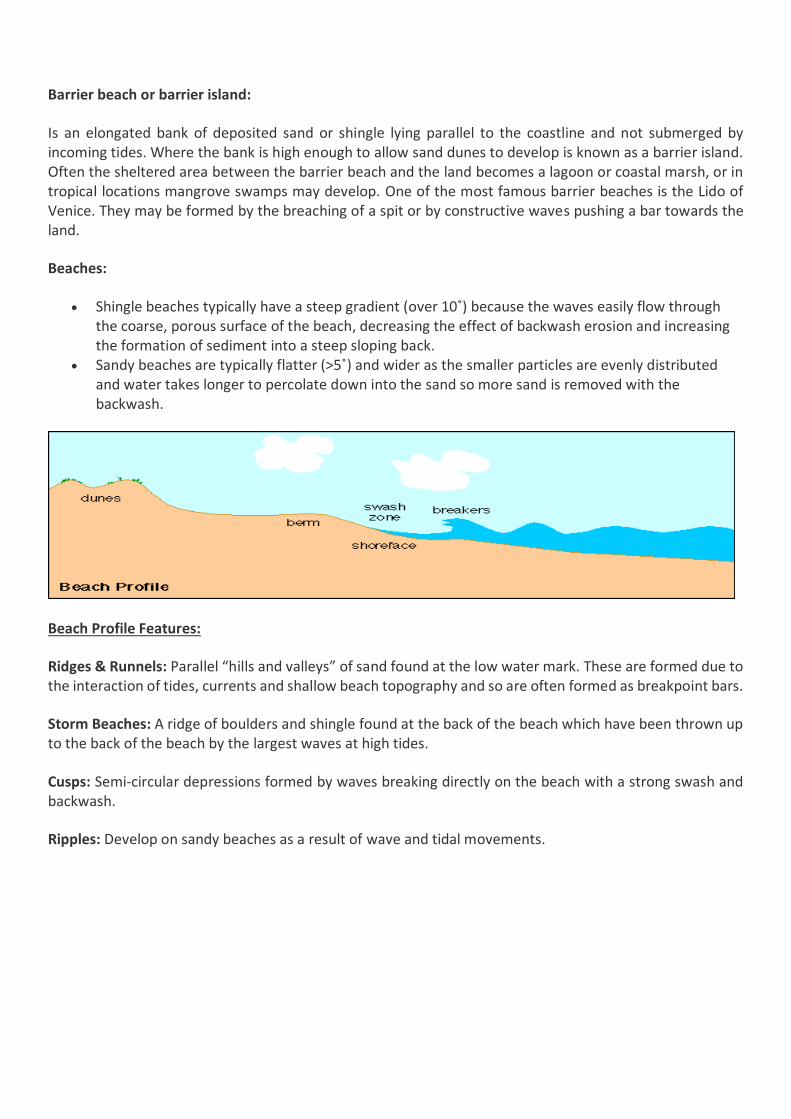
Beaches:
Shingle beaches typically have a steep gradient (over 10˚) because the waves easily flow through the coarse, porous surface of the beach, decreasing the effect of backwash erosion and increasing the formation of sediment into a steep sloping back.
Sandy beaches are typically flatter (>5˚) and wider as the smaller particles are evenly distributed and water takes longer to percolate down into the sand so more sand is removed with the backwash.
Beach Profile Features:
Ridges & Runnels: Parallel “hills and valleys” of sand found at the low water mark. These are formed due to the interaction of tides, currents and shallow beach topography and so are often formed as breakpoint bars.
Storm Beaches: A ridge of boulders and shingle found at the back of the beach which have been thrown up to the back of the beach by the largest waves at high tides.
Cusps: Semi-circular depressions formed by waves breaking directly on the beach with a strong swash and backwash.
Ripples: Develop on sandy beaches as a result of wave and tidal movements.
A beach plan is formed as a product of the angle at which waves approach a beach.
Drift aligned beaches are produced where waves break at an angle to the coast. The swash therefore occurs at an angle but the backwash runs perpendicular to the beach. As a result, material is transported along the beach via longshore drift.
Some beaches show oblique alignments to the dominant wave fronts. This usually occurs where the beach gradient is steep and the wavelength is short. This is because the waves break at different points on the beach.
Swash aligned beaches (e.g. Hell’s Mouth) are produced where the waves break in line (parallel) with the coast. Swash & backwash movements move material up and down the beach producing the aforementioned beach profile features. Swash aligned beaches are smoothly curved, concave beaches. The beach face is orientated parallel to the fronts of the dominant waves. Beaches which face the waves are termed swash aligned.
Saltmarshes:
Salt marshes only form in low energy environments where there is shelter from the wind and waves. Depositional landforms such as spits can help provide this shelter. Salt marshes require a large input of sediment which can arrive from the sea and rivers. The most likely place along a coastline where you’ll find this sort of sediment input is near a tidal flat. The low gradient of a tidal flat means that any rivers that flow into it will very quickly deposit any sediment they’re transporting. At the same time, the periodic flooding of the tidal flat by the tides will deposit even more sediment.
Over time, sediment accumulates and the elevation of the tidal flat increases in a process known as coastal accretion. This reduces the duration of tidal flooding allowing a small selection of plants to grow on the now developing salt marsh. These plants are halophytic—they love salt—and are capable of surviving underwater for several hours a day. They’re often called pioneer species because of their hardy nature and, well, pioneering growth on salt marshes. These plants, which include species of cordgrass (Spartina) and glasswort (Salicornia)1, have several adaptations that not only help them thrive in saline environments but also help aid coastal accretion.
Long blades of cordgrass trap sediment that is too fine to settle out of water in a salt marsh, building up a muddy substrate. At the same time, the roots of the cordgrass plant (that are long to tap into the water table) help stabilise already deposited sediment, aiding coastal accretion. Pioneer species such as Spartina alterniflora (a species of cordgrass) are invasive plants that spread rapidly. Once these plants are introduced to a salt marsh, coastal accretion takes place quickly and the elevation of the salt marsh increases greatly. This creates new environments that are submerged by the tide for shorter periods of time, allowing even more species of plants and animals to colonise the salt marsh.
There are several conditions that need to be met for sand dunes to develop. First, a large supply of sediment is needed. The best place to get this is from a large tidal flat. An area with a large tidal range (a big difference between the high and low tide) will result in a lot of sand being exposed to the wind, ready to be transported. This brings us to our next condition. A (relatively) strong and continuous wind is needed to move sand grains and transport them inland via saltation. The best place to find strong winds that don’t change direction is in areas that face the prevailing wind direction.
With these conditions met, it’s now only a matter of time until a sand dune starts to form. Obstacles such as rocks or human rubbish are deposited at the strandline—essentially the high water mark. These objects block the wind causing sand grains that are being transported to be deposited. Over time, the sand grains will build up and encompass the object forming a very small embryo dune.
Eventually pioneer species of plants will start to grow on the embryo dune. As they do so, they bind the sand together, increasing the stability of the dune. The vegetation itself also traps sand causing the embryo dune to grow even more. As the dune grows it becomes a foredune and a new embryo dune begins to develop in front of it. This is the beginning of a sand dune succession.
Embryo Dunes: As we’ve already discussed, embryo dunes are the first part of a sand dune succession. They form in the shadow of obstacles at the strandline. As sand is deposited, pioneer species such as prickly saltwort (Kali Turgida) colonise the embryo dune and begin to bind the sand together.The conditions on embryo dunes are harsh so plants have to have special adaptations to colonise them. The pH of the soil (which is essentially sand at this point) is very high (~8–8.5). This is because of the large number of marine shells deposited in embryo dunes. The shells are made from the mineral calcite (and sometimes aragonite3) which is also known as calcium carbonate. Calcium Carbonate is an alkaline and so as it is broken down in the soil, it increases its pH.
The high pH limits plant growth to only very hardy species. Growth is further limited by the high salinity of the soil and the lack of fresh water. At the strandline, plants won’t be submerged by the sea but they will be splashed by it and so they have to be halophytic (salt tolerant). The lack of fresh water means they need to have long roots to reach the water table. These long roots help stabilise the embryo dune.
Foredunes/Yellow Dunes: The vegetation that grows in an embryo dune trap sand in their stems and help stabilise the embryo dune. This causes the embryo dune to grow until a new embryo dune starts to form in front of it. At this point, our old embryo dune becomes a foredune. As the dune is still composed mainly of sand, foredunes are also called yellow dunes because of their yellow colour. To make things even more
confusing, because the sand is still relatively un-compacted these dunes, along with embryo dunes, are also called mobile dunes.
Because of the pioneer species that lived on the embryo dune, conditions have changed in the foredune and they’re now more hospitable to life. The vegetation on the embryo dune has decreased the soil’s pH. The soil is still alkaline (pH ~7.5–8) but it is now tolerable to a wider range of plants. Marram grass often grows in foredunes. Like prickly saltworth, marram grass is a halophyte and has long roots to tap into the water table. These roots again help bind the sand, increasing the foredune’s stability. Marram grass grows tall very quickly though. This means that the plant can trap a lot of sand without burying itself in sand, allowing the foredune to grow quite big.
Marram grass has an interesting adaptation for living on foredunes. As it is quite long, to reduce damage from the wind it is made from very thin blades. This makes it more aerodynamic but reduces how much rainwater it can collect. To combat this, during light winds its blades fold outwards to collect more water. Then, as the wind picks up, the blades fold in to protect them from the wind.
Grey Dune: As the plant life on a foredune dies, it forms a layer of humus (not the same thing as hummus). This is an organic layer of soil that is somewhat acidic and helps lower the pH of the soil to ~6–7. The higher organic content of the foredune gives it a grey colour and it is now known as a grey dune. As the soil is now more stable, it is also known as a fixed dune.
The lowered pH allows some new species of plants to develop. Vegetation such as marram grass will still prevail though as grey dunes are still dry and exposed to the wind. The really interesting vegetation grows in dune slacks.
Dune Slacks: Dune slacks are very large depressions in sand dune successions that are often deep enough to expose the water table. There are two ways they can form. If a foredune grows large enough it can form a dune ridge that prevents any further deposition of sediment inland by blocking the wind. The low point behind the ridge is the dune slack. Since there’s little erosion taking place behind the dune ridge, the water table generally isn’t exposed in the dune slack.
The more interesting dune slacks form as a result of blowouts. Excessive trampling and grazing of plants on a dune will reduce the stability of the dune since there’s no roots to bind it together. This makes it easier to erode the dune, producing a deep depression in the succession that often reaches down to the water table.
As fresh water is exposed at the surface, new types of vegetation can grow in the dune slack, in particular reeds and rushes. A dune slack that forms behind a grey dune often contains a variety of vegetation because the humus on the grey dune is blown into the dune slack making it even more hospitable.
Sea Level Change:
The sea level has and continues to fluctuate greatly throughout time. On a day to day basis, the sea level changes according to the tide but the sea level also changes on a much grander time scale too. These changes in sea level are normally caused by ice ages or other major global events.
The sea level changes for a variety of reasons. These reasons can be put into two categories, eustatic and isostatic change, depending on if they have a global effect on sea level or a local effect on the sea level.
Eustatic change is when the sea level changes due to an alteration in the volume of water in the oceans or, alternatively, a change in the shape of an ocean basin and hence a change in the amount of water the sea can hold. Eustatic change is always a global effect. During and after an ice age, eustatic change takes place. At the beginning of an ice age, the temperature falls and water is frozen and stored in glaciers inland, suspending the hydrological cycle. This results in water being taken out of the sea but not being put back in leading to an overall fall in sea level. Conversely, as an ice age ends, the temperature begins to rise and so the water stored in the glaciers will re-enter the hydrological cycle and the sea will be replenished, increasing the sea levels. Increases in temperature outside of an ice age will also effect the sea level since an increasing temperature will cause the ice sheets to melt, putting more water in the sea. The shape of the ocean basins can change due to tectonic movement. If the ocean basins become larger, the volume of the oceans becomes larger but the overall sea level will fall since there’s the same amount of water in the ocean. Conversely, if the ocean basins get smaller, the volume of the oceans decreases and the sea level rises accordingly.
Isostatic sea level change is the result of an increase or decrease in the height of the land. When the height of the land increases, the sea level falls and when the height of the land decreases the sea level rises. Isostatic change is a local sea level change whereas eustatic change is a global sea level change. During an ice age, isostatic change is caused by the build up of ice on the land. As water is stored on the land in glaciers, the weight of the land increases and the land sinks slightly, causing the sea level to rise slightly. This is referred to as compression. When the ice melts at the end of an ice age, the land begins to rise up again and the sea level falls. This is referred to decompression or isostatic rebound. Isostatic rebound takes place incredibly slowly and to this day, isostatic rebounding is still taking place from the last ice age. Isostatic sea level change can also be caused by tectonic uplift or depression. As this only takes place along plate boundaries, this sort of isostatic change only takes place in certain areas of the world.
Emergent landforms:
Raised beaches: Around the coastline there is evidence of relatively higher sea levels in the form of raised beaches. These are deposits of sand and pebbles on gently sloping platforms backed by an old cliff line, which may contain fossil sea caves, wave-cut platforms and even arches. At Westward Ho! in Devon the raised beach is 5m above present sea-level and formed during an interglacial 100,000 years ago, when sea-levels were 10m higher than at present. In Scotland the land has rebounded by 100m since the ice sheets retreated, and with the added factor of sea-level rise the east Scottish coast near St Andrews contains many example of relic beaches, which form terraces along the coastline Base level changes/rejuvenation If the land over which a river flows rebounds and relative sea-level falls, the river’s erosive processes will be rejuvenated as it tries to erode down to a new base level. The base level of a river is the most efficient gradient for the river to flow down. This process will start from the lower reaches of the river near the sea. As the river erodes upstream, a waterfall or steep section will retreat upstream, forming a gorge or deepened valley. This active erosive point is called a knick point. Downstream of the knick point, terraces may form where the river has cut through the old floodplain. Entrenched meanders may occur when vertical erosion is very rapid, e.g. River Wear, Durham. Ingrown meanders occur when uplift is less rapid and the meanders are able to erode laterally.
Submergent landforms:
These are the opposite of emergent landforms. They form when the eustatic rise in sea level takes place faster than the isostatic rebound after an ice age. Basically, the water starts to flood the land and fills up landforms on the land.
One submergent feature is a Ria. This is a river valley that’s been flooded by the eustatic rise in sea level. They’re almost exactly like a typical river valley but they have even more water in them. The cross section of a ria is really similar to the one you’d find for a river in the lower course. One thing to note, the floodplain of the river also gets flooded, altering the cross profile of a ria ever so slightly so that it includes the floodplain.
Another submergent feature is a Fjord. These are steeper and deeper variants of riases that are relatively narrow for their size. They have a u-shaped cross profile and are often found in particularly icy sections of the world. The final submergent feature is a dalmatian coastline. These form in areas of the world where valleys (especially glacial valleys) lie parallel to each other. When the valleys are flooded by the rise in sea level, the tops of the valleys remain above the surface of the sea and appear to be a series of islands that run parallel to the coastline. The best example of a dalmatian coastline is the one from which they get their name, the Dalmatian coast in Croatia.
Recent and predicted climate change and the potential impacts:
Two processes are causing the current sea level changes:
An increase in the volume of oceans due to melting ice caps and thermal expansion
Subsistence of the coast
Predicting climate change is difficult as it involves complex modelling. However, potential impacts of rising sea levels on coasts could include:
Increased coastal flooding, particularly with spring tides and strong onshore winds.
More coastal erosion and cliff erosion as waves attack areas previously above high tide.
Receding coastlines.
An upstream movement of the zone where seawater mixes with fresh water in rivers.
Increased flooding of areas away from the coastline as rivers flood more.
Greater frequency and magnitude of extreme sea level events, such as storm surges.
Increased erosion of dunes, salt marshes and mudflats.
Increased investment in coastal protection for areas of high economic value.
Coastal Management:
Key Concept / Key Question Tick when
confident
What is the difference between hard and soft engineering in terms of
coastal management?
Explain each of the hard engineering approaches
Explain each of the soft engineering approaches
What are the sustainable approaches to flood risk?
What are the sustainable approaches to coastal erosion? (Shoreline
Management Plans and Integrated Coastal Zone Management)
Coastal Management:
It’s becoming increasingly important for councils and governments to start managing coastlines in order to protect them from increasing coastal erosion and flooding due to altering sea levels. The reason for coastal management is obvious, to protect homes and businesses from being damaged and even destroyed by coastal erosion or flooding. Failure to do so can have severe economic and social effects, especially along coastlines which are used for tourism and industry (pretty much all of them).
Management of coastlines is also important to help protect natural habitats, however governments generally don’t engage in coastal management where there isn’t an economic risk as effective coastal management is very expensive.
When engaging in coastal management, there’s four key approaches that can be taken:
1. Hold the line - Where existing coastal defences are maintained but no new defences are set up. 2. Advance the line - New defences are built further out in the sea in an attempt to reduce the stress
on current defences and possibly extend the coastline slightly. 3. Retreat the line (surrender) - Move people out of danger zones and let mother nature unleash take
control. 4. Do nothing - The easy option, deal with the effects of flooding and erosion as they come or just ignore
them. This is generally what happens in areas where there’s no people, and so nothing of “value” (to the government) to protect.
Like most engineering schemes in geography, there’s hard and soft coastal engineering. As usual, hard engineering techniques are high technology, high cost, human made solutions. They do little to work with nature and sustainability is a key issue with them, despite their initial signs of success. Soft engineering techniques are low tech, low cost solutions that work with nature to reduce erosion. They’re nowhere near as effective as hard engineering techniques but they’re far more sustainable.
Sea Walls: These are the most obvious defensive methods. Sea walls are exactly that. Giant walls that span entire coastlines and attempt to reduce erosion and prevent flooding in the process. They’re big, ugly and very expensive requiring constant maintenance so that they don’t fail. They also produce a strong backwash in waves which undercuts the sea wall making their long term sustainability questionable.
Traditionally, sea walls are large flat walls however more modern sea walls have a curved structure that reflects waves back into incoming waves, breaking them up and further reducing erosion.
Groynes: Groynes are relatively soft hard engineering techniques. They’re low lying wooden walls that extend out to sea. The idea of groynes is to capture sand that moves down the beach via longshore drift and help build up a larger section of beach in front of an area that’s experiencing coastal erosion. The new beach will increase the distance that waves have to travel to reach the coast and, in the process, they’ll lose most of their energy, reducing their impact. Groynes are pretty effective but they have one major drawback. Groynes will remove a lot of the sand that’s present down-drift of the beach which will result in a thinner beach at this area. This, in turn, means that sections of the coast will be more exposed to erosion down drift of the groynes which can create new problems relating to coastal management.
Gabions: Gabions are quite simply bundles of rocks in a metal mesh. They’re placed at the base of a cliff in an attempt to reduce the impact of waves on the cliff and prevent the cliff from being undercut. They’re not particularly effective and they’re quite unsightly but they’re sure as hell cheap.
Revetments: Revetments are concrete (or in some cases wooden) structures that are built along the base of a cliff. They’re slanted and act as a barrier against waves not too dissimilar to a sea wall. The revetments absorb the energy of the waves, preventing the cliffs from being eroded. Revetments can be modified so that they have rippled surfaces, which further help to dissipate the wave energy. Revetments are normally successful at reducing coastal erosion but they are expensive to build. Once built however, they don’t require as much maintenance as a sea wall.
Riprap: Riprap are just rocks and stones that have been put against the base of a cliff. They’re similar to gabions in their purpose but they aren’t bound together in a mesh. This makes them look slightly more appealing as they blend into the environment better however the rocks are susceptible to being moved by the sea.
Breakwaters: Breakwaters are offshore concrete walls that break incoming waves out at sea so that their erosive power is reduced to next to none when they reach the coast. Breakwaters are effective but they can be easily destroyed during a storm and they don’t look particularly nice.
Tidal barriers: Big, retractable walls built across estuaries that can be used as a floodgate to prevent storm surges. They’re hugely effective but they’re also hugely expensive.
Soft Engineering Techniques:
Beach Nourishment: This is where sand and shingle are added to a beach in order to make it wider. This increases the distance a wave has to travel to reach the cliffs and so the wave will lose more energy and have less erosive power when it reaches the cliffs. The sand and shingle has to be obtained from elsewhere and is normally obtained from dredging.
Land Management: Land management is often used to help protect and rebuild dunes. Sand dunes act as a good barrier against coastal flooding and erosion and they can be exploited as a natural defence against the sea. In order to do so though, the dunes must be left relatively undisturbed so boardwalks are constructed and sections of sand dune systems are marked as out of bounds to the general public in order to reduce the erosion of the dunes by humans.
Marshland Creation: Marshland can be used to break up the waves and reduce their speed, reducing the waves erosive power. The marshlands also limit the area which waves can reach preventing flooding. The marshlands can be created by encouraging the growth of marshland vegetation such as glassworts.
Beach Stabilisation: The goal of beach stabilisation is the same as beach nourishment’s goal, to widen the beach and dissipate as much wave energy as possible before it reaches the cliffs. Beach stabilisation involves planting dead trees in the sand to stabilise it and lower the profile of the beach while widening the beach too.
Sustainable approaches to coastal flood and erosion risk:
Shoreline Management Plans:
The strategy of a shoreline management plan (SMPs) uses a combination of approaches that aim to be cost effective and long lasting. Hard engineering is used in areas where erosion or flooding could cause greatest economic loss, with soft engineering used where there may be a fragile ecosystem or where it is possible to work with natural processes. The overall management plan aims to be economically, socially and environmentally sustainable.
SMPs comprise three strategies:
Hold the line
No active intervention
Managed realignment
The basic units for SMPs in England and Wales are within the 11 sediment cells. Within these, lengths of coast known as sub-cells are identified for management.
Integrated coastal zone management plans:
Integrated coastal zone management plans (ICZM) originated from the UN Earth Summit, Rio 1992. The aims are set out in agenda 21 documents. ICZM is designed to integrate the views and interests of all stakeholders in a management issues and to coordinate policies that affect the coastal zone, such as fishing, agriculture, industry and offshore energy.
Case Studies
Local UK Case Study = Holderness coast Eastern England
Beyond the UK = Odisha coast in India
Key Concept / Key Question Tick when
confident
Case study of coastal environment(s) at a local scale to illustrate and
analyses fundamental coastal processes, their landscape outcomes as set
out above and engage with field data and challenges represented in their
sustainable management.
Case study of a contrasting coastal landscape beyond the UK to illustrate
and analyses how it presents risks and opportunities for human occupation
and development and evaluate human responses of resilience, mitigation
and adaptation.
Coastal Processes at the Holderness Coast:
The Holderness coast is a well-known stretch of coastline in eastern England. It forms a sub-cell in Sediment
Cell 2 and essentially comprises three distinct coastal units.
Flamborough Head in the north, a chalk promontory that exhibits many typical landforms associated
with coastal erosion.
Bridlington Bay to Spurn Head, an extensive zone of erosion and sediment transfer characterised by
a very rapid rate of cliff retreat.
Spurn Head, a classic spit formed at the estuary of the river Humber.
Within this subcell, the main input is erosion of the weak and unconsolidated till cliffs. Some of the finer
sediment is washed offshore to form an output from the system while the slightly coarser material is moved
southwards as a transfer involving longshore drift. Some sediment is deposited to form Spurn Head, while a
significant amount continues south towards the Wash and East Anglia.
Factors affecting the coastal system:
Rapid rates of erosion occur on this coastline.
Geology is an important affecting the process and landforms of the Holderness coast. Chalk, a
relatively resistant rock, forms a broad arc in the region stretching from the Lincolnshire Wolds to
Flamborough Head.
As sea levels rose at the end of the last glacial period, the North Sea took shape and started to erode
the thick till deposits to help form the present day cliffs.
Long fetch from the north east drives powerful waves.
North east prevailing wind and waves results in north to south longshore drift.
As a result of rapid rates of erosion in the area parts of the coastline have been protected with hard
engineering structures such as sea walls, rock armour and groynes. These have made helped
Mappleton and Hornsea but have deprived areas further south of the sediment resulting in faster
rates of erosion.
Landforms:
Chalk cliffs at Selwick Bay
Headlands, wave cut platforms and stacks at Flamborough Head.
Beaches at Spurn Head
Spit at Spurn Head
Challenges with sustainable management at Holderness:
Long fetch and powerful waves account for the rapid rates of erosion
Weak and unconsolidated till and boulder clay cliffs
Extensive mass movement, especially slumping caused by undercutting and the saturation of clay
Narrow beaches making the cliffs vulnerable to wave attach and undercutting
Lack of coastal defenses as they are expensive to implement and some cost benefit analyses suggest
they should not be implemented.
Management of one area may bring adverse effects to another.
Risk and opportunity for human occupation in Odisha, India
Odisha is a state on the south-east coast of India bordering the Bay of Bengal. It is India’s 9th largest state by area and
11th by population. Odisha has a relatively straight coastline (about 480km long) with few natural inlets or harbors.
The narrow, level coastal strip known as the Odisha Coastal Plains supports the bulk of the states population.
The coastal plain mostly comprises depositional landforms of recent origin, geologically belonging to the post-Tertiary
Period. There are six major deltas on the Odisha coast, which explains why the coastal plan is known locally as the
‘Hexadeltaic region’ or the ‘Gift of Six Rivers’.
The Odisha coast has a wide range of coastal marine flora and fauna (including 1435km2 of mangrove forest). One
well known environment is the Chilka Lake, a brackish salty lagoon, well known for its birdlife. It is a good example of
a temporary store in the water cycle; the beach has created the lake is an important store of water within the coastal
system.
In summary, the Odisha coast is essentially one of deposition, comprising several major deltas. It therefore represents
a significant sediment store, providing a source of sediment for this part of the Bay of Bengal. Rivers provide important
transfers of sediment into the region forming deltaic deposits.
Risks Opportunities
The Shoreline Change Assessment for Odisha Coast, 2011
outlined the following risks to the area:
- Coastal erosion is getting worse in the area in
particular in the south
- Local communities at risk of from possible storm
surges and tsunamis in the future.
- Climate change may lead to rising sea levels
- Hard engineering management approaches are only
shifting the issues to other parts of the coast.
- The coast is changing all the time through deposition
and erosional processes.
- Dense mangrove vegetation bring high levels of
accretion
- Only 14.4% of the coast is classified as being stable.
- Seasonal variations make the area very difficult to
manage.
- Flat land for settlements to be built
- Variety of marine and coastal flora and fauna
including mangroves, sea grasses, salt marshes, sand
dunes, estuaries and lagoons.
- Large stocks of fish for fishermen in the area.
- Many local employed in aquaculture in particular
shrimps.
- Olive Ridley Turtles live in the area.
- Huge potential for offshore wind, tidal and wave
power.
- Lots of clay and limestone resources in the area.
- Tourism bring money to the region with the wildlife
and beaches.
- The Chilka Lake Bird Sanctuary boasts over 150
species of birds.
Human responses of resilience, mitigation and adaptation.