U.S. Department of the Interior Minerals Management Service Gulf of Mexico OCS Region OCS Study MMS 99-0049 Coastal Upwelling and Mass Mortalities of Fishes and Invertebrates in the Northeastern Gulf of Mexico during Spring and Summer 1998 Final Report
Transcript
U.S. Department of the InteriorMinerals Management ServiceGulf of Mexico OCS Region
OCS StudyMMS 99-0049
Coastal Upwelling and Mass Mortalitiesof Fishes and Invertebrates in theNortheastern Gulf of Mexico duringSpring and Summer 1998
Final Report
U.S. Department of the InteriorMinerals Management ServiceGulf of Mexico OCS Region
New OrleansSeptember 1999
OCS StudyMMS 99-0049
Coastal Upwelling and Mass Mortalitiesof Fishes and Invertebrates in theNortheastern Gulf of Mexico duringSpring and Summer 1998
Final Report
Authors
Sneed B. CollardUniversity of West Florida
Alexis Lugo-FernándezMinerals Management Service
Prepared under MMS Cooperative Agreement1435-01-98-CA-30963byUniversity of West Florida1100 University ParkwayPensacola, Florida 32514-5751
ii
DISCLAIMER
This report was prepared under contract between the Minerals Management Service (MMS) andUniversity of West Florida. This report has been technically reviewed by the MMS and approvedfor publication. Approval does not signify that the contents necessarily reflect the views andpolicies of the Service, nor does mention of trade names or commercial products constituteendorsement or recommendation for use. It is, however, exempt from review and compliancewith MMS editorial standards.
REPORT AVAILABILITY
Extra copies of the report may be obtained from the Public Information Office (Mail Stop 5034)at the following address:
U.S. Department of the InteriorMinerals Management ServiceGulf of Mexico OCS RegionPublic Information Office (Mail Stop 5034)1201 Elmwood Park BoulevardNew Orleans, Louisiana 70123-2395
Telephone Number: 1-504-736-25191-800-200-GULF
CITATION
Suggested citation:
Collard, S.B. and A. Lugo-Fernández. 1999. Coastal Upwelling and Mass Mortalities of Fishesand Invertebrates in the Northeastern Gulf of Mexico During Spring and Summer 1998. OCS Study MMS 99-0049. U.S. Department of the Interior, Minerals ManagementService, Gulf of Mexico OCS Region, New Orleans, La. 20 pp.
COVER
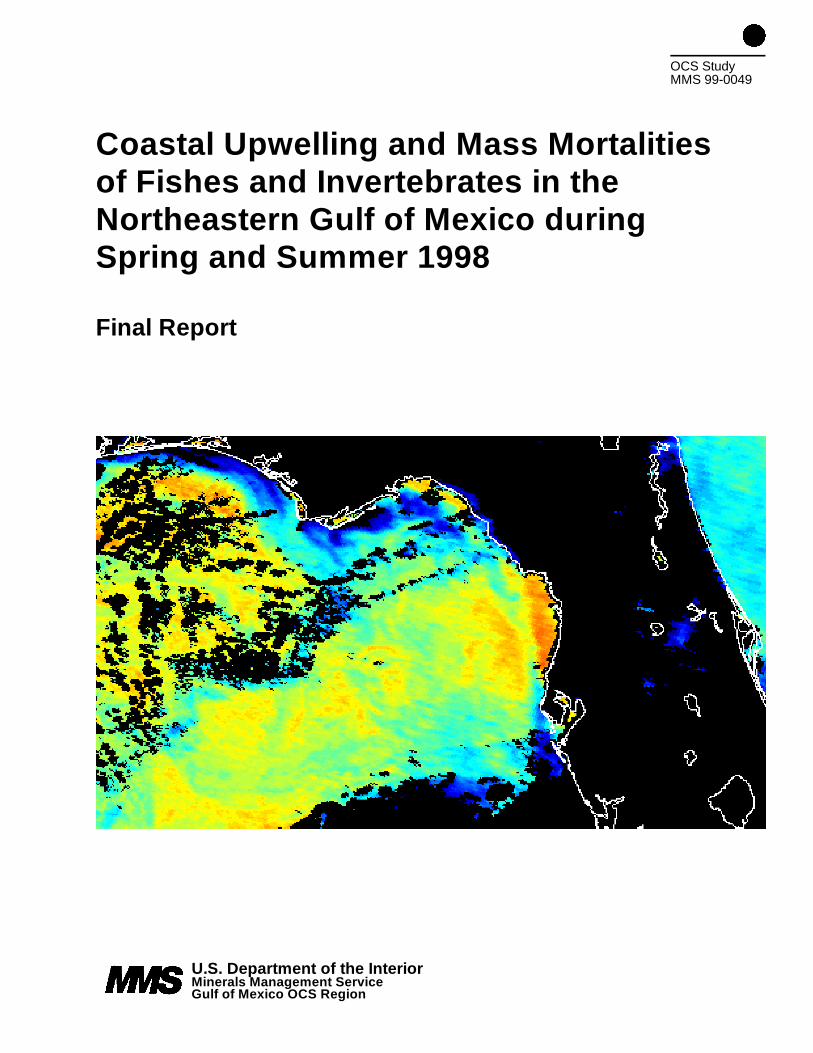
The cover, an AVHRR satellite image, shows a band of cool (blue color) upwelled water over thenearshore region of the northeastern Gulf of Mexico during May 24, 1998. Image courtesy of Dr.Frank Muller-Karger of University of South Florida, St. Petersburg, Florida.
iii
ACKNOWLEDGMENTS
Many people contributed information summarized in this report. The authors are particularlygrateful to Gary Fitzhugh, John Brusher, Rosalie Shaffer and Herb Kumpf (National MarineFisheries Service); Wilton Sturges (Florida State University); Worth Nowlin, Matt Howard andAnn Jochens (Texas A&M University); Frank Muller-Karger, Chuanmin Hu and Tracey Sutton(University of South Florida); Gary Goeke, Jim Price and Walter Johnson (Minerals ManagementService); Will Schroeder (University of Alabama, Dauphin Island Sea Lab); Patrice Edwards(Florida Department of Environmental Protection); Evans Waddell and Peter Hamilton (ScienceApplications International Corporation); John Hitron (Florida State University MarineLaboratory); and Barry A. Vittor (Barry A. Vittor & Associates).
iv
ABSTRACT
Climatic conditions associated with an El Niño event in summer of 1998 resulted in upwellingfavorable winds, with higher than usual rainfall and river discharge of local rivers. This event wasaccompanied by unseasonably cooler water temperatures and elevated concentration of nutrientsin the shelf of the northeastern Gulf of Mexico. Dense algal blooms were observed in response toupwelling and nutrient availability. Freshwater and the near-bottom cool dense waters created ahighly stratified water column that suppressed vertical mixing and aeration of the bottom layer. Sinking dead algae and high biological oxygen demand, in combination with the stable watercolumn led to near anoxic conditions over the mid-shelf bottom. Mass mortalities of fishes andinvertebrates were observed in the region during this event, probably as a result of low oxygen. While certain climatic features were unusual, the area’s prevailing oceanographic regime wasneither unusual nor anomalous. Major long-term consequences of the upwelling event areexpected to be relatively minor.
1 Area affected by the cold water event in the northeastern Gulf of Mexico. 1
2 Tombigbee River discharge in 1998. Mean discharge (solid line) 6plus/minus one standard deviation (broken lines).From Nowlin et al. (1998).
3 Wind vectors from stations around the northeastern Gulf of Mexico 7from May to August 1998. From Nowlin et al. (1998).
4 Near bottom temperature time series from the DeSoto Canyon stations. 8From Nowlin et al. (1998).
5 Sea surface height on the northeast Gulf of Mexico from April to 9August 1998. From Nowlin et al. (1998).
6 Acoustic Doppler Current profiler vectors at 50 m from May 5-16, 1998. 10From Nowlin et al. (1998).
7 Near-bottom dissolved oxygen from May 5-16, 1998. 11From Nowlin et al. (1998).
vii
List of Tables
Table Title Page
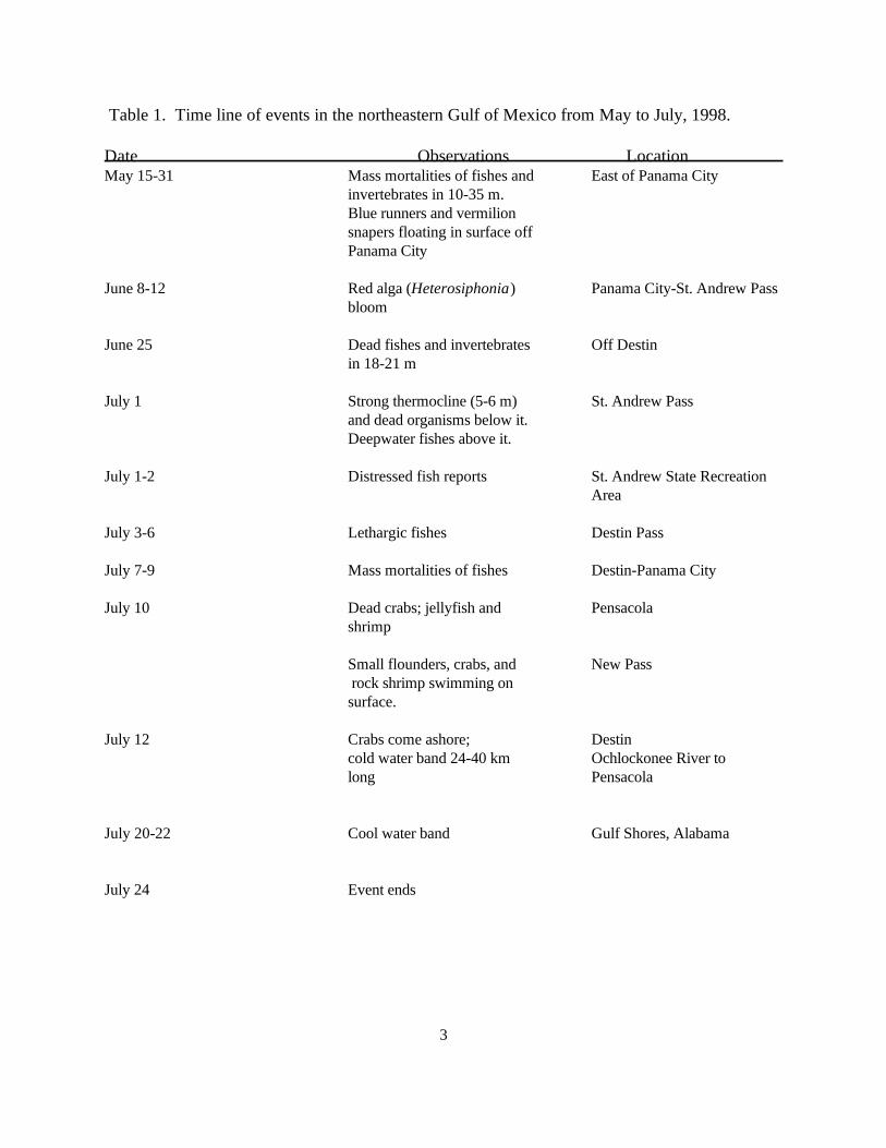
1 Time line of events in the northeastern Gulf of Mexico 3 from May to July, 1998.
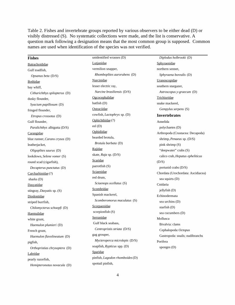
2 Fishes and invertebrate groups reported by various observers to 4 be either dead (D) or visibly distressed (S). No systematic
collections were made, and the list is conservative. A question mark following a designation means that the most common group is supposed. Common names are used when identification of the
species was not verified.
Gulf Shores
Pensacola
DestinPanama City
A-1
C-1
D-1
E-1
Lou i s i ana
Miss i ss ipp i
Mississ ippi R.
Alabama
Flo r ida
50 0 50 100 Kilom e ters
Gulf of Mexico
LakePontchar t ra in St. Andrew
BayApalachee
Bay
C a p e San Blas
Tombi gb ee R .
Ochlo
cone
e R.
ChoctawhatcheeBay
1000m
1000m
100m
100m
1
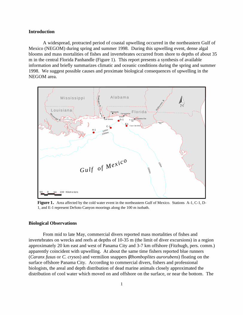
Figure 1. Area affected by the cold water event in the northeastern Gulf of Mexico. Stations A-1, C-1, D-1, and E-1 represent DeSoto Canyon moorings along the 100 m isobath.
Introduction
A widespread, protracted period of coastal upwelling occurred in the northeastern Gulf ofMexico (NEGOM) during spring and summer 1998. During this upwelling event, dense algalblooms and mass mortalities of fishes and invertebrates occurred from shore to depths of about 35m in the central Florida Panhandle (Figure 1). This report presents a synthesis of availableinformation and briefly summarizes climatic and oceanic conditions during the spring and summer1998. We suggest possible causes and proximate biological consequences of upwelling in theNEGOM area.
Biological Observations
From mid to late May, commercial divers reported mass mortalities of fishes andinvertebrates on wrecks and reefs at depths of 10-35 m (the limit of diver excursions) in a regionapproximately 20 km east and west of Panama City and 3-7 km offshore (Fitzhugh, pers. comm.)apparently coincident with upwelling. At about the same time fishers reported blue runners(Caranx fusus or C. crysos) and vermilion snappers (Rhomboplites aurorubens) floating on thesurface offshore Panama City. According to commercial divers, fishers and professionalbiologists, the areal and depth distribution of dead marine animals closely approximated thedistribution of cool water which moved on and offshore on the surface, or near the bottom. The
2
presence of warm near-surface water over cool water created a strong thermocline reported tooccur at depths of 3-12 m. Table 1 presents a time line of this and other biological events in theNEGOM which are discussed below.
On 8 June, following a period of offshore winds and nearshore upwelling (Nowlin et al., inpress), a dense population of a cool water-tolerant filamentous red alga, Heterosiphonia gibbesii(Moncreiff, fide Shaffer, pers. comm.) was reported along and offshore Panama City beaches. Concentrations of Heterosiphonia appeared to move on- and offshore with cool water at irregularintervals, and reports of thick mats of algae in the water column and on the bottom continueduntil 12 July. After 12 July, concentrations of Heterosiphonia markedly decreased when thepopulation died off or was cleared from the area by winds and currents, although algae continuedto wash on beaches episodically the remainder of the summer. Accumulations of algae in St.Andrew Pass, on area beaches, and in coastal waters were usually associated with dead fish andinvertebrates (Shaffer, pers. comm.).
On 25 June, large numbers of dead fishes and invertebrates were reported on reefs offDestin in water depths of 18-21 m. At a depth of about 12 m “colder than normal” (normal T~25 C) water was encountered, and currents were reported to be eastward. On 1 July, NationalMarine Fisheries Service (NMFS) divers reported a strong thermocline at 4.5-7.5 m, in water 14m deep in St. Andrew Pass. Visibility at the bottom was reduced to a few meters by floc and raftsof what appeared to be green algae. At the surface and at 7.5 m depth, respectively (the length ofthe Hydrolab cable), temperatures were 29.0 and 21.4 C; salinities were 32.8 and 35.3; anddissolved oxygen concentrations were 5.91 and 0.37 mg L . NMFS divers reported that all of-1
the organisms seen below 6 m were dead except for crabs, which were moribund. Above thethermocline, fishes generally associated with deeper water or bottom habitats were seen (Table 2). At 14 m depth, bottom water temperature, salinity, and dissolved oxygen concentration were, respectively, 19 C, 35.3, and 0.37 mgL . -1
During low tides on 1-2 July, NMFS biologists observed distressed fish in St. Andrew StateRecreation Area tidal pools; dead juvenile flounders, crabs and lethargic fishes inside the St.Andrew Pass jetties; and dead eels, burrfish, cowfish, crabs, starfish and sea cucumbers outsidethe pass, and on area beaches (Table 2). Water at the beaches was characterized as green andthick with algae. Mass mortalities did not recur (or were not reported) in the Panama City-Destinarea during 3-6 July, and nearshore Gulf waters were reported to be clear and well mixed, withreduced algal densities. While fishkills were not reported during this four day period, largeschools of lethargic fish (Spanish mackerel, “baitfish” and stingrays) were seen in the shallows atDestin Pass.
During the period 26 June-12 July, distressed, moribund and dead fishes and invertebrateswere observed from the intertidal zone to about 30 m depth in the St. Andrew Bay-Destin region. Deepwater animals were observed at the surface offshore and in shallow water near shore duringthis period. Algal densities were observed to be much higher than usual. From 7-14 July, watertemperatures at Panama City beaches varied between 18-20 C. Cool water and mass mortalities— similar in magnitude and species composition to those of 1-2 July, recurred in the Destin-Panama City area from 7-9 July, and fishers reported that highly stratified water, with currentssetting to the east, extended 24 km offshore.
3
Table 1. Time line of events in the northeastern Gulf of Mexico from May to July, 1998.
Date Observations Location May 15-31 Mass mortalities of fishes and East of Panama City
June 8-12 Red alga (Heterosiphonia) Panama City-St. Andrew Pass
June 25 Dead fishes and invertebrates Off Destin
July 1 Strong thermocline (5-6 m) St. Andrew Pass
July 1-2 Distressed fish reports St. Andrew State Recreation
July 3-6 Lethargic fishes Destin Pass
July 7-9 Mass mortalities of fishes Destin-Panama City
July 10 Dead crabs; jellyfish and Pensacola
July 12 Crabs come ashore; Destin
July 20-22 Cool water band Gulf Shores, Alabama
July 24 Event ends
invertebrates in 10-35 m. Blue runners and vermilionsnapers floating in surface offPanama City
bloom
in 18-21 m
and dead organisms below it. Deepwater fishes above it.
shrimp
Small flounders, crabs, and New Pass rock shrimp swimming onsurface.
cold water band 24-40 km Ochlockonee River tolong Pensacola
Area
4
Table 2. Fishes and invertebrate groups reported by various observers to be either dead (D) orvisibly distressed (S). No systematic collections were made, and the list is conservative. Aquestion mark following a designation means that the most common group is supposed. Commonnames are used when identification of the species was not verified.
FishesBatrachoididae
Gulf toadfish,
Opsanus beta (D/S)
Bothidae
bay whiff,
Citharichthys spilopterus (D)
dusky flounder,
Syacium papillosum (D)
fringed flounder,
Etropus crossotus (D)
Gulf flounder, Annelida
Paralichthys albigutta (D/S)
Carangidae
blue runner, Caranx crysos (D)
leatherjacket,
Oligoplites saurus (D)
lookdown, Selene vomer (S)
round scad (cigarfish),
Decapterus punctatus (D)
Carcharhinidae (?)
sharks (D)
Dasyatidae
stingray, Dasyatis sp. (S)
Diodontidae
striped burrfish,
Chilomycterus schoepfi (D)
Haemulidae
white grunt,
Haemulon plumieri (D)
French grunt,
Haemulon flavolineatum (D)
pigfish,
Orthopristias chrysoptera (D)
Labridae
pearly razorfish,
Hemipteronotus novacula (D)
unidentified wrasses (D)
Lutjanidae
vermilion snapper,
Rhomboplites aurorubens (D)
Narcinidae
lesser electric ray,
Narcine brasiliensis (D/S)
Ogcocephalidae
batfish (D)
Ostraciidae
cowfish, Lactophrys sp. (D)
Ophichthidae (?)
eel (D)
Ophidiidae
bearded brotula,
Brotula barbata (D)
Rajidae
skate, Raja sp. (D/S)
Scaridae
parrotfish (S)
Sciaenidae
red drum,
Sciaenops ocellatus (S)
Scombridae
Spanish mackerel,
Scomberomorus maculatus (S)
Scorpaenidae
scorpionfish (S)
Serranidae
Gulf black seabass,
Centropristis striata (D/S)
gag grouper,
Mycteroperca microlepis (D/S)
soapfish, Rypticus spp. (D)
Sparidae
pinfish, Lagodon rhomboides (D)
spottail pinfish,
Diplodus holbrooki (D)
Sphyraenidae
northern sennet,
Sphyraena borealis (D)
Uranoscopidae
southern stargazer,
Astroscopus y-graecum (D)
Trichiuridae
snake mackerel,
Gempylus serpens (S)
Invertebrates
polychaetes (D)
Arthropoda (Crustacea: Decapoda)
shrimp, Penaeus sp. (D/S)
pink shrimp (S)
“deepwater” crabs (S)
calico crab, Hepatus epheliticus
(D/S)
portunid crabs (D/S)
Chordata (Urochordata: Ascidiacea)
sea squirts (D)
Cnidaria
jellyfish (D)
Echinodermata
sea urchins (D)
starfish (D)
sea cucumbers (D)
Mollusca
Bivalvia: clams
Cephalopoda: Octopus
Gastropoda: snails; nudibranchs
Porifera
sponges (D)
5
On 10 July, the water column was weakly stratified (21 C on the surface, and 19 C on thebottom at 12-13 m) in St. Andrew Pass, and strongly stratified 1.6 km offshore (25 C on thesurface and 19 C at 12-13 m). Fishers reported that bottom currents were from west-to-east 16-64 km offshore. On 10 July, dead crabs, jellyfish and sharks washed up on Pensacola beaches, butcorrelation between the deaths of these organisms and upwelling is uncertain.
On 11-12 July, a diver reported surface conditions over the wreck Elvira located 6.4 kmsouth of Destin in water 26 m deep, to be relatively warm (~ 24 C) with 12 m visibility. At about9 m depth a strong thermocline was encountered and the water was turbid, with visibility reducedto about two meters. At a depth of about 14 m, water temperatures ‘evened out’ near 18C, andvisibility increased to about 8 m. Numerous fishes were seen at 24 m, but these appeared to besluggish. Similar conditions were encountered at the wreck Louise in 17 m of water, but“everything was dead — crabs, snails, clams, grouper, batfish, everything...”
On 12 July, fishers reported thousands of small flounders, rock shrimp, ‘regular shrimp’and crabs swimming on the surface in the New Pass area at St. Andrew Bay. At Destin, live,deepwater crabs were observed to be coming ashore in large numbers. Water temperaturesduring this time were reported to be about 6.5-8.5 C colder than surrounding water in a 24-40km wide band of water extending from the Ochlockonee River to Pensacola. Cold waterextended from a depth of 6 m beneath the surface to the bottom, and was reported to be “blackand murky.”
From 13-16 July, charter boat captains and divers reported cool water inshore and warmerwater offshore, with dense algae extending 9-10 km offshore. Surf temperatures were 21.7 C atPanama City, and 25 C at Pensacola. On a line from 8 km south of Panama City to the St. Joesea buoy, surface and bottom (15 m) temperatures were 29.0 C and 20.5 C, respectively(FDEP, pers. comm.). On 17 July a commercial diver reported that large milky clouds ofunknown composition were seen about 9-10 km off Destin Pass, and that similar substances wereobserved in the pass on 4 July.
From 20-22 July, nearshore water became clearer, and surface temperatures increased to27 C in the Panama City area. Satellite images indicated that cool water had moved to the west,and on 19 July, large numbers of lesser electric rays were observed in clear, cool water along a1.6 km-long stretch of beach at Gulf Shores, Alabama (Vittor, pers. comm.). On 23 July, NMFSreported that the cold water event was dissipating and that water clarity was improving. Coastalwinds in the Panama City-Pensacola area shifted to the southeast on 24 July, sea surfacetemperatures increased to 29 C, and fishers reported good catches of sharks, Spanish and kingmackerel, grouper, snapper and redfish from Panama City to St. Joe Bay.
From information collected by NMFS biologists and marine scientists from other state andfederal agencies (Fitzhugh et al., pers. comm.), mass mortalities on reefs appeared to becatastrophic. Offshore areas were apparently affected at different times, as cool water movedfrom east to west. For example, mortalities on reefs 20 km east of Panama City occurred in May,while reefs west of Destin, but not as far west as Pensacola, apparently experienced mortalities inJune-mid July. Reports of dead fish floating on the surface offshore were received throughout theten week period, while dead organisms washed up on beaches in the Panama City area were mostfrequently observed between 27 June and 12 July.
In addition to reports of dead animals, numerous observations were made of fishes andinvertebrates exhibiting symptoms associated with low oxygen stress. Benthic species (e.g.,
6
Figure 2. Tombigbee River discharge in 1998. Mean discharge (solid line)plus/minus one standard deviation (broken lines). From Nowlin et al. (1998).
shrimp, crabs, some fishes) were seen swimming on the surface; lethargic fishes were observedbelow the thermocline; and shrimp and crabs were reported to be “crawling out of the water” —similar to “jubilees” that occur periodically in Mobile Bay due to low dissolved oxygenconcentrations.
Climatic Conditions
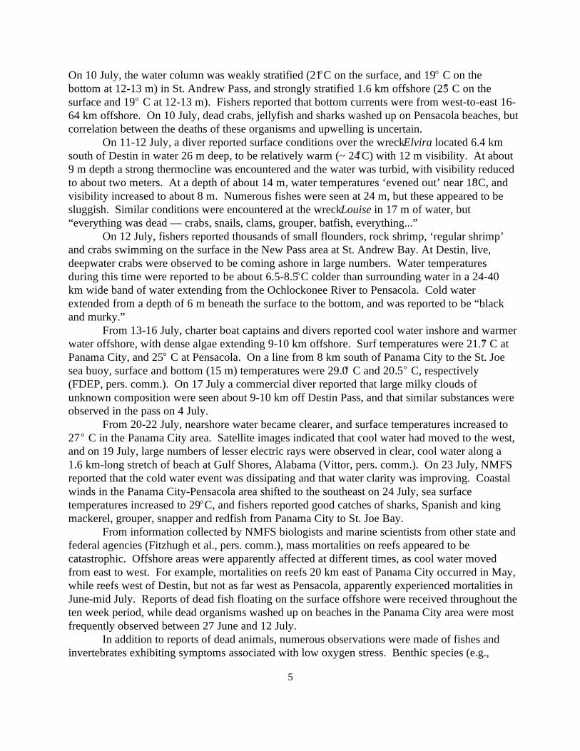
Unusual climatic conditions in the NEGOM from winter 1997 through mid-summer 1998were attributable to complex interactions between a strong 1997-1998 El Niño-SouthernOscillation (ENSO) and a persistent negative phase North Pacific Oscillation (NP) teleconnectionpattern (U.S. Department of Commerce, 1998a). According to the U.S. Department ofCommerce (1998b), from January to February 1998 the southeastern U.S. experienced warm,stormy weather and heavy rainfall in advance of a pronounced, ENSO-related high pressure ridgethat extended over the tropics and subtropics. Rainfall amounts increased as the ridge movednorth. Large volumes of fresh water associated with floods in southern Alabama, Georgia andFlorida entered the northeastern Gulf of Mexico from Mobile Bay to the Big Bend region of theFlorida Panhandle during the second and third weeks of March (U.S. Department of Commerce,1998b and c). During this time, runoff was above the long-term (14-70 years) average flow atmost local rivers (Figure 2).
Peak discharge volumes ofthe Mississippi River (30,583m •s ) did not reach the Gulf until the third week of May, due to the northward reach of its much3 -1
larger watershed (Miller, U.S. Army Corps of Engineers, pers. comm.). In late March, as the highpressure ridge moved northward into the south-central United States, warm, wet weather in the
7
Figure 3. Wind vectors from stations around the northeastern Gulf of Mexico from May toAugust 1998. From Nowlin et al. (1998).
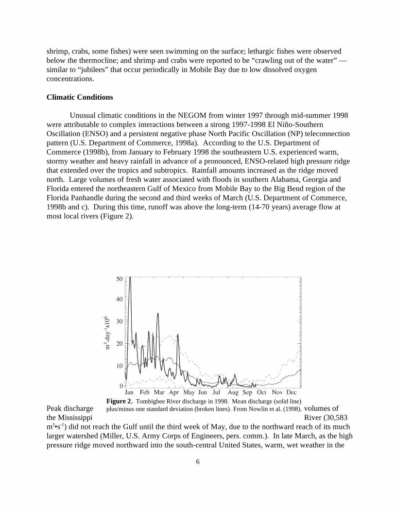
southeast was replaced by record-setting hot, dry conditions that persisted through late July, whenthe residual effects of the 1997-1998 El Niño on NEGOM climatic conditions dissipated (U.S.Department of Commerce, 1998b, c, and d). Coupled with atypical temperature and precipitationpatterns, regional winds were also influenced by the ENSO-ridge system and, after its movementto the north, by a large atmospheric high pressure cell that dominated the Gulf of Mexico throughmost of July.
It is useful to compare descriptions of average (i.e., non-ENSO) winds in the NEGOMwith those observed during spring-summer 1998. According to Blaha and Sturges (1981), windsare westward and relatively calm during spring, and without a dominant east-west componentfrom May to July. Wolfe et al. (1988) and Tanner (1992) characterized prevailing spring-summerwinds as northwestward or northeastward; and SAIC (1997) described late spring and summerwinds as relatively calm and onshore, in agreement with Blaha and Sturges (1981).
Unlike these patterns, upper level and surface winds in the NEGOM were predominantlyeastward and northeastward under the influence of the northern arm of a large atmospheric highpressure cell during spring-summer 1998 (Purdue University, 1998). Nowlin et al. (in press)described regional surface winds from April to August 1998 as generally eastward and onshore,with a strong offshore wind event at the end of the first week in June (Figure 3). Sturges (pers.comm.) found that the alongshore mean winds were predominantly eastward from Januarythrough mid-July, except for a month-long period of weak westward flow from mid-Marchthrough mid-April. Price (pers. comm.) analyzed NEGOM surface winds and demonstrated thatMay-June 1998 winds were more northeastward and eastward than in May-June 1997.
8
Figure 4. Near bottom temperature times series from the DeSotoCanyon stations. From Nowlin et al. (1998).
Oceanography
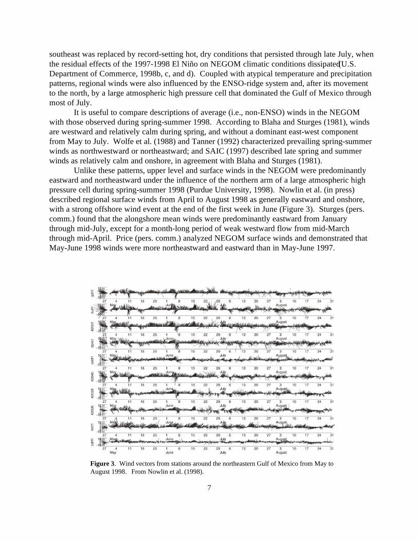
Information presented here was extracted from the results of an extensive investigation ofhydrographic conditions and their evolution in the NEGOM from early April to early August 1998(Nowlin et al., in press). A complete dataset and detailed analyses are found in Nowlin et al.(1998).
In a search for evidence of upwelling prior to cruise N2 in May, Nowlin et al. (1998)examined a time series of near-bottom temperature records from four moorings located near the100 m isobath in the NEGOM (Figure 1). From west to east, mooring locations A-E werelocated, respectively, southeast of the Chandeleur Islands, south of Pensacola Bay, southwest ofChoctawhatchee Bay, and southwest of
St. Andrew Bay, at the head of DeSoto Canyon (SAIC, 1998). Temperature records indicatedthat two pulses of cool bottom water in April at moorings C and D were followed some ten dayslater by a cool water intrusion at mooring E. There was no evidence of cool water at 100 m
9
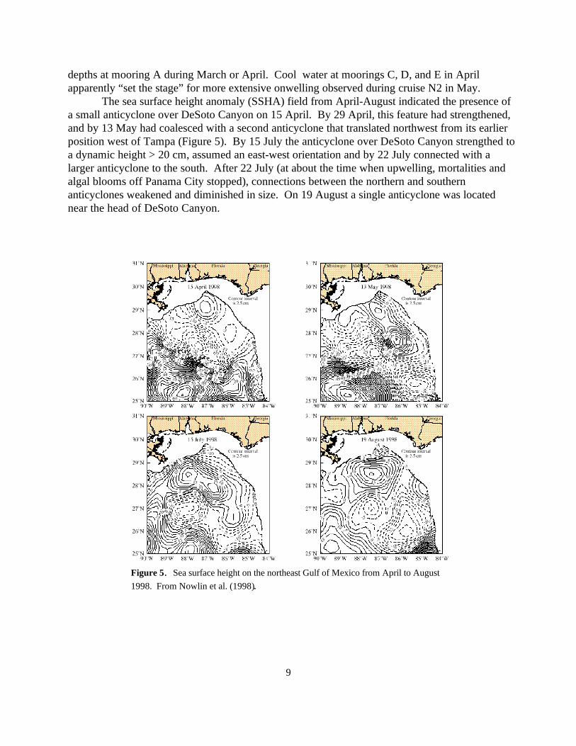
Figure 5. Sea surface height on the northeast Gulf of Mexico from April to August1998. From Nowlin et al. (1998).
depths at mooring A during March or April. Cool water at moorings C, D, and E in Aprilapparently “set the stage” for more extensive onwelling observed during cruise N2 in May.
The sea surface height anomaly (SSHA) field from April-August indicated the presence ofa small anticyclone over DeSoto Canyon on 15 April. By 29 April, this feature had strengthened,and by 13 May had coalesced with a second anticyclone that translated northwest from its earlierposition west of Tampa (Figure 5). By 15 July the anticyclone over DeSoto Canyon strengthed toa dynamic height > 20 cm, assumed an east-west orientation and by 22 July connected with alarger anticyclone to the south. After 22 July (at about the time when upwelling, mortalities andalgal blooms off Panama City stopped), connections between the northern and southernanticyclones weakened and diminished in size. On 19 August a single anticyclone was locatednear the head of DeSoto Canyon.
10
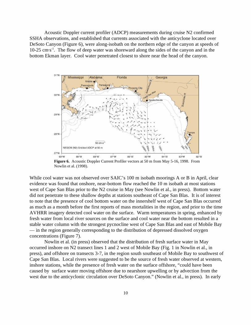
Figure 6. Acoustic Doppler Current Profiler vectors at 50 m from May 5-16, 1998. FromNowlin et al. (1998).
Acoustic Doppler current profiler (ADCP) measurements during cruise N2 confirmedSSHA observations, and established that currents associated with the anticyclone located overDeSoto Canyon (Figure 6), were along-isobath on the northern edge of the canyon at speeds of10-25 cm s . The flow of deep water was shoreward along the sides of the canyon and in the-1
bottom Ekman layer. Cool water penetrated closest to shore near the head of the canyon.
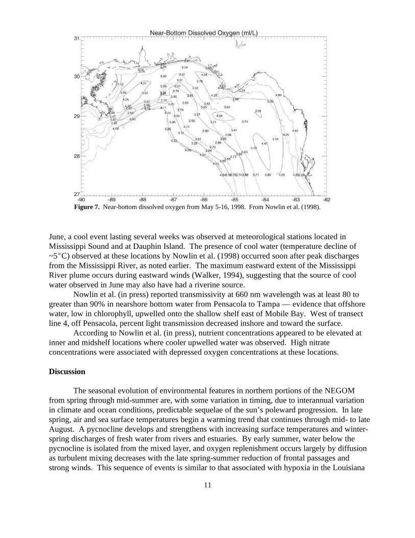
While cool water was not observed over SAIC’s 100 m isobath moorings A or B in April, clearevidence was found that onshore, near-bottom flow reached the 10 m isobath at most stationswest of Cape San Blas prior to the N2 cruise in May (see Nowlin et al., in press). Bottom waterdid not penetrate to these shallow depths at stations southeast of Cape San Blas. It is of interestto note that the presence of cool bottom water on the innershelf west of Cape San Blas occurredas much as a month before the first reports of mass mortalities in the region, and prior to the timeAVHRR imagery detected cool water on the surface. Warm temperatures in spring, enhanced byfresh water from local river sources on the surface and cool water near the bottom resulted in astable water column with the strongest pycnocline west of Cape San Blas and east of Mobile Bay— in the region generally corresponding to the distribution of depressed dissolved oxygenconcentrations (Figure 7).
Nowlin et al. (in press) observed that the distribution of fresh surface water in Mayoccurred inshore on N2 transect lines 1 and 2 west of Mobile Bay (Fig. 1 in Nowlin et al., inpress), and offshore on transects 3-7, in the region south southeast of Mobile Bay to southwest ofCape San Blas. Local rivers were suggested to be the source of fresh water observed at western,inshore stations, while the presence of fresh water on the surface offshore, “could have beencaused by surface water moving offshore due to nearshore upwelling or by advection from thewest due to the anticyclonic circulation over DeSoto Canyon.” (Nowlin et al., in press). In early
11
Figure 7. Near-bottom dissolved oxygen from May 5-16, 1998. From Nowlin et al. (1998).
June, a cool event lasting several weeks was observed at meteorological stations located inMississippi Sound and at Dauphin Island. The presence of cool water (temperature decline of~5 C) observed at these locations by Nowlin et al. (1998) occurred soon after peak dischargesfrom the Mississippi River, as noted earlier. The maximum eastward extent of the MississippiRiver plume occurs during eastward winds (Walker, 1994), suggesting that the source of coolwater observed in June may also have had a riverine source.
Nowlin et al. (in press) reported transmissivity at 660 nm wavelength was at least 80 togreater than 90% in nearshore bottom water from Pensacola to Tampa — evidence that offshorewater, low in chlorophyll, upwelled onto the shallow shelf east of Mobile Bay. West of transectline 4, off Pensacola, percent light transmission decreased inshore and toward the surface.
According to Nowlin et al. (in press), nutrient concentrations appeared to be elevated atinner and midshelf locations where cooler upwelled water was observed. High nitrateconcentrations were associated with depressed oxygen concentrations at these locations.
Discussion
The seasonal evolution of environmental features in northern portions of the NEGOMfrom spring through mid-summer are, with some variation in timing, due to interannual variationin climate and ocean conditions, predictable sequelae of the sun’s poleward progression. In latespring, air and sea surface temperatures begin a warming trend that continues through mid- to lateAugust. A pycnocline develops and strengthens with increasing surface temperatures and winter-spring discharges of fresh water from rivers and estuaries. By early summer, water below thepycnocline is isolated from the mixed layer, and oxygen replenishment occurs largely by diffusionas turbulent mixing decreases with the late spring-summer reduction of frontal passages andstrong winds. This sequence of events is similar to that associated with hypoxia in the Louisiana
12
shelf (Wiseman et al., 1994). Prevailing spring and summer winds in coastal regions of theNEGOM are northerly, easterly, southerly or nearly calm (Blaha and Sturges, 1981; SAIC, 1997),depending on the period of record and distribution of stations selected for analysis. Prevailingwesterly winds (i.e., to the east), as observed through most of the period from January throughlate July 1998, are uncommon in the NEGOM.
In addition to unusual winds, precipitation patterns during the first seven months of 1998were atypical with respect to the 104 year period of record. Above average volumes of freshwater entered east-central portions of the NEGOM throughout winter, and a large, days-long“pulse” of fresh water from heavy rains in coastal watersheds reached this region of the Gulf inmid-March. It is likely that nutrient loading in shelf waters increased during the period of highriver runoff and estuarine flushing. Rainfall ended after mid-March, and unusually warm, dryweather dominated eastern portions of the NEGOM until late July. With increasing temperatures,the cessation of storms and greatly diminished discharges of fresh water, a strong pycnocline mayhave developed in NEGOM shelf waters in late March or April, a month or more earlier than theseasonal norm.
Unusual climatic conditions were temporally correlated with, but probably causallyunrelated to anticyclonic ocean features in the NEGOM described by Nowlin et al. (in press). Asdescribed by these authors, clockwise circulation and cool water upwelling were forced by ananticyclone located over DeSoto Canyon during the period of interest from April through July1998. Nowlin et al. (in press) demonstrated that widespread upwelling occurred prior to their 5-16 May cruise, with the penetration of cool, near-bottom water to, or possibly inshore of the 10 misobath on much of the shelf between Mississippi Sound and Cape San Blas. The maximumpenetration of cool bottom water during the first half of May and in mid-July occurred near thehead of the DeSoto Canyon. Reports of unusually cool water nearshore and observations ofdistressed or dead marine organisms suggest that pulses of cool water also penetrated toinnershelf depths after mid-May, in June and in early July.
Nowlin et al. (in press) presented clear evidence of upwelling prior to early May, howeverAVHRR satellite images of sea surface temperatures indicate that upwelled water did not reachthe surface in nearshore shelf waters until about 11-12 May, after which it was detected (withconsiderable temporal and areal variation), between Mississippi Sound and the southern Big Bendregion through 18-20 July. Remote sensing (Muller-Karger, in press) supported by observationsof commercial divers suggests that upwelling was strong and persistent west of Cape San Blasand east of Pensacola Bay, generally corresponding to the region where mass mortalities occurredand ecological impacts were most pronounced. Ecological conditions were less affected east andwest of what appears to have been the central, or core upwelling area.
Strong innershelf upwelling occurred prior to cruise N2 in May, several weeks beforemass mortalities were first reported. Because cause and effect between upwelling and massmortalities are uncertain, speculative and non-mutually exclusive explanations for the weeks-longlag between upwelling and mass mortalities are offered, with implicit caveats. First, it is possiblethat dissolved oxygen concentrations in upwelled DeSoto Canyon water were higher in April andmid-May than during the last two weeks of May. Dense concentrations of the tropical, coolwater-tolerant alga, Heterosiphonia cf. gibbesii (see Pakker et al., 1995) were not observed untillate May-early June, within the time frame of mass mortality events on reefs off Panama City. The source of Heterosiphonia is not known, but a propagule of some size may have been
13
transported onto the shelf by anticyclonic currents described earlier. According to Nowlin et al.(in press), chlorophyll concentrations beneath the pycnocline were low (80 to >90% transmissionat 660 nm) suggesting that the algal population occupied and increased in the upper layer. Itappears that Heterosiphonia physiological tolerance to cool water is greater than that of thenormal “June grass” bloom of Cladophora, a warm water alga. As nutrients in the upper layerwere depleted by growth of the algal bloom which co-occurred with blooms of non-toxicdinoflagellates and other phytoplankters, the Heterosiphonia population began to die, sankbeneath the pycnocline, and contributed to a positive feedback loop of increasing biologicaloxygen demand (BOD) and decreasing dissolved oxygen concentrations. Wiseman et al. (1997)demonstrated the strong relationship between hypoxia and stratification. Evidence supportingvery low dissolved oxygen concentrations is weak, and based on one credible measurement. Hypoxic oxygen concentrations ( 2 mg L ) were not encountered by Nowlin et al. (1998),-1
although concentrations near 3 mgL were measured during cruise N2 in early May. Mass-1
mortalities attributed to low dissolved oxygen concentrations also occurred after cruise N2,suggesting that hypoxic or anoxic conditions also occurred after mid May. For this view to havemerit, it must be assumed that hypoxia or anoxia developed rapidly — not only in the benthicboundary layer, but a sufficient distance above the bottom to account for the vertical reach ofwrecks and reefs. Under a strong pycnocline it may be possible that respiration in resident benthiccommunities, coupled with the consumption of oxygen by microbial decomposers, could havebeen great enough to rapidly lower dissolved oxygen concentrations to levels stressful or fatal tomarine organisms. Rabalais et al. (1994) states that hypoxia could develop in the lower watercolumn in days, weeks, or months.
A second speculation is coupled with the first. Elevated nutrient concentrations inupwelled water were observed at inner and midshelf depths offshore St. Andrew Bay,Choctawhatchee Bay and Santa Rosa Sound, where organically rich sediments and high nutrientlevels have been well documented (SAIC, 1997). It is possible that Hurricanes Allison, Erin andOpal, which passed over these estuaries in 1995, translocated large amounts of their sediments tothe shelf (see Isphording et al., 1987). With the additional flushing of nutrients and organically-rich sediments during flood conditions in mid-March 1998, chemical oxygen demand (COD), inaddition to an increased biological oxygen demand associated with algal decomposition, may haveconsumed much of the oxygen from upwelling water as it moved shoreward.
Other, somewhat less convoluted explanations are proposed. These suggest that: (1)Hypoxic (< 2 mg L ) or anoxic water believed to be responsible for mass mortalities from mid--1
May through early July may not have originated in DeSoto Canyon, but advected into the regionfrom the west; or (2) Water from DeSoto Canyon upwelled onto the shelf (but not to the surface)in April, where it remained as a relatively cool bottom layer beneath a strong pycnocline. Duringsucceeding weeks (until about mid-May) dissolved oxygen in the relic water mass was graduallydepleted as a result of high BOD/COD demand. It is difficult to attribute mass mortalities tocauses other than oxygen stress. Toxic dinoflagellates were not present in abundance, and resultsof toxic screening by the Florida Marine Research Institute were negative (FMRI, pers. comm.).
Although many marine organisms died during the upwelling event, systematic samplingwas not possible, and neither the numbers of organisms nor the species involved can be known orapproximated with confidence. Divers tend to avoid reefs known to have suffered extensivemortalities, and follow-on observations of benthic, reef-associated organisms, if made, are
14
unknown to the authors. In late July, however, pelagic fishes in the vicinity of reefs were reportedto appear normal in abundance and diversity.
Summary and Conclusions
Atypical climatic conditions in portions of the NEGOM, including eastward winds andearly formation of a pycnocline were related to the 1997-1998 ENSO and atmospheric dynamicconditions (ENSO-NP). Eastward and shoreward shelf currents and the upwelling of deep waterfrom DeSoto Canyon were attributable to a persistent anticyclone located over the canyon.Correlations but not causation between climate and ocean conditions were found. Massmortalities of pelagic and benthic organisms in the Panama City-Destin region are attributed toputative hypoxic, or perhaps anoxic conditions caused by a large biological oxygen demand. BOD was clearly exacerbated by a dense algal population of a tropical, but cool water-tolerantspecies of red alga, Heterosiphonia cf. gibbesii. Resuspension of nutrient-rich sedimentsdeposited on the shelf by floods in 1998, and by hurricanes in 1995 may have contributed toincreased total oxygen demand. Correlations but not causation between cool water upwelling,hypoxia, anoxia, and mass mortalities were found. The ecological consequences of dramatic, butrelatively short-term mass mortalities in populations of adult benthic and pelagic animals, and ofmeroplankters recruiting to shelf habitats could not be adduced from the information available. Major long-term consequences of the upwelling event are expected to be relatively minor.
It is important to notice that oceanographic conditions (e.g. stratification) associated withthis event are similar to those associated with hypoxia events in the Louisiana shelf. While inLouisiana the summer pynocline is essentially a halocline (Wiseman et al., 1994), the 1998NEGOM pynocline resulted from salinity differences due to higher than usual runoff plustemperature differences due to atypical cool-upwelled waters. The nutrient pulse from the highriver discharge and/or sediment resuspension created the algal bloom, driving the high BOD/CODand the ensuing hypoxic conditions.
15
Literature Cited
Blaha, J. and W. Sturges. 1981. Evidence for wind-forced circulation in the Gulf of Mexico. J.Mar. Res. 39(4):711-734.
Isphording, W.C., F.D. Imsand, and G.C. Flowers. 1987. Storm-related rejuvenation of anorthern Gulf of Mexico estuary. Trans. Gulf Coast Assoc. Geol. Soc. 37:357-370.
Muller-Karger, F. 1998. Remote sensing. U.S. Dept. Of the Interior, Minerals ManagementService, 18 Inform. Transfer Mtg. (in press).th
Nowlin, W.D., Jr., A.E. Jochens, M.K. Howard, and S.F. DiMarco. In press. Nearshore, bottomproperties over the northeastern shelves of the Gulf of Mexico as observed during early May1998. U.S. Dept. of the Interior, Minerals Management Service, 18 Inform. Transfer Mtg.th
Nowlin, W.D., Jr., A.E. Jochens, M.K. Howard, and S.F. DiMarco. 1998. Nearshore, bottomproperties over the northeastern shelves of the Gulf of Mexico as observed during early May1998. TAMU Oceanography, Tech. Rpt. No. 98-3-T, 60 pp.
Pakker, H., A.M. Breeman, W.F. P. van Reine, and C. van den Hoek. 1995. A comparative studyof temperature responses of Caribbean seaweeds from different biogeographic groups. J. Phycol.31: 499-507.
Purdue University. 1998. Image and map archive: upper air charts. Online. Internet.Available<http://wxp.eas.purdue.edu/archive/eta_init/> (et seq.).
Rabalais, N.N., W.J. Wiseman, Jr., R.E. Turner, 1994. Comparison of continuous records ofnear-bottom dissolved oxygen from the hypoxia zone along the Louisiana coast. Estuaries17(4):850-861.
Science Applications International Corporation. 1997. Northeastern Gulf of Mexico coastal andmarine ecosystem program: Data search and synthesis; synthesis report. U.S. Dept. Of theInterior, Geological Survey, Biological Resource Division, USGS/BRD/CR-1997-005 andMinerals Management Service, Gulf of Mexico OCS Region, New Orleans, LA, OCS StudyMMS 96-0014, 313 pp.
Science Applications International Corporation. 1998. DeSoto Canyon eddy intrusion study.Statistical data products: set 4. April 1998 - August 1998. Tech. Rep. MMS Contract 1435-01-96-CT-30825. Unpaginated.
Tanner, W.F. 1992. Natural environment. In: Atlas of Florida (E.A. Fernald and E.D. Purdum,eds.). Inst. Sci. Public Affairs, Florida St. Univ., Univ. FL Press, pp. 12-77.
16
U.S. Department of Commerce. 1998a. Teleconnection patterns. National Oceanic andAtmospheric Administration, National Weather Service, National Environmental Satellite, DataInformation Service. Online. Internet. Available<http://nic.fb4.noaa.gov:80/data/teledoc/teleintro.html >
U.S. Department of Commerce. 1998b. January and February, 1998: Warmest and wettest onrecord. National Oceanic and Atmospheric Administration; National Environmental Satellite,Data, Information Service; NESDIS Press Release March 9, 1998. Online. Internet. Available <http://www.ncdc.noaa.gov/ol/climate/warmest.html >
U.S. Department of Commerce. 1998c. Special climate summary 98/1: Atmospheric conditionsaffecting the United States during April - June 1998. National Oceanic and AtmosphericAdministration, National Weather Service, National Centers Environmental Prediction, ClimatePrediction Center. Online. Internet. Available <http://nic.fb4.noaa.gov/products/special_summaries/98_1/ >
U.S. Department of Commerce. 1998d. Special climate summary 98/2: Atmospheric conditionsaffecting the United States during July and early August 1998.National Oceanic and AtmosphericAdministration, National Weather Service, National Centers Environmental Prediction, ClimatePrediction Center. Online. Internet. Available <http://nic.fb4.noaa.gov/products/special_summaries/98_2/ >
Walker, N.D. 1994. Satellite-based assessment of the Mississippi River discharge plume’s spatialstructure and temporal variability. OCS Study MMS 94-0053. U.S. Dept. Of the Interior,Minerals Management Service, Gulf of Mexico OCS Region, New Orleans, LA., 56 pp.
Wiseman, W.J., N.N. Rabalais, R.E. Turner, S.P. Dinnel, and A. MacNaughton, 1997. Seasonaland interannual variability within the Louisiana coastal current: stratification and hypoxia. J. ofMarine System 12:237-248.
Wolfe, S.H., J.A. Reidenauer and D.B. Means. 1988. An ecological characterization of theFlorida Panhandle. U.S. Fish Wildlife Service Biological Rep. 88(12); Minerals ManagementService OCS Study, MMS 88-0063, 277 pp.
The Department of the Interior Mission
As the Nation's principal conservation agency, the Department of the Interior has responsibility formost of our nationally owned public lands and natural resources. This includes fostering sound use ofour land and water resources; protecting our fish, wildlife, and biological diversity; preserving theenvironmental and cultural values of our national parks and historical places; and providing for theenjoyment of life through outdoor recreation. The Department assesses our energy and mineralresources and works to ensure that their development is in the best interests of all our people byencouraging stewardship and citizen participation in their care. The Department also has a majorresponsibility for American Indian reservation communities and for people who live in island territoriesunder U.S. administration.
The Minerals Management Service Mission
As a bureau of the Department of the Interior, the Minerals Management Service's (MMS) primaryresponsibilities are to manage the mineral resources located on the Nation's Outer Continental Shelf(OCS), collect revenue from the Federal OCS and onshore Federal and Indian lands, and distributethose revenues.
Moreover, in working to meet its responsibilities, the Offshore Minerals Management Programadministers the OCS competitive leasing program and oversees the safe and environmentally soundexploration and production of our Nation's offshore natural gas, oil and other mineral resources. TheMMS Royalty Management Program meets its responsibilities by ensuring the efficient, timely andaccurate collection and disbursement of revenue from mineral leasing and production due to Indiantribes and allottees, States and the U.S. Treasury.
The MMS strives to fulfill its responsibilities through the general guiding principles of: (1) beingresponsive to the public's concerns and interests by maintaining a dialogue with all potentially affectedparties and (2) carrying out its programs with an emphasis on working to enhance the quality of life forall Americans by lending MMS assistance and expertise to economic development and environmentalprotection.
Minerals Management ServiceGulf of Mexico OCS Region