30
coastlines, dunes, rivers, mountains, glaciers, deltas, lakes, aquifers, caverns, and/or sinkholes Landforms
| Date post: | 16-Dec-2015 |
| Category: |
Documents |
| Upload: | alban-dalton |
| View: | 218 times |
| Download: | 1 times |
coastlines, dunes, rivers, mountains, glaciers, deltas, lakes, aquifers, caverns, and/or sinkholes
Landforms

Topography refers to the elevation and relief of the Earth’s surface.
Landforms are the topographic features on the Earth’s surface.
Geomorphology is the study of earth surface processes and landforms.
2
The maps above represent the same area on Earth’s surface and they show three different ways we can view landforms. The image on the far left is a clip from a topographic elevation map, the image in the middle is an infrared aerial photo, and the image on the right is the
geologic interpretation of surface sediments and geomorphology. This location is interesting because it contains elements of a natural and human altered physical environment. The lake
in the image, (coded blue in the topographic and geology map, and black in the infrared aerial photo) was formed by artificial damming a stream the flows through this landscape.

Topography
Blue
Ridge
Piedm
ont
Coast
al P
lain

Crustal Orders of Relief
I. First Order or Relief: Continental Landmasses and Ocean Basins
II. Second Order of Relief:Major Continental and Ocean Landforms
III. Third Order of Relief:Genetic Landform Features
Beaches Rivers and Flood Plains Mountains

Constructive Processes Constructive processes build landforms through
tectonic and depositional processes. Tectonic processes include movements at plate
boundaries, earthquakes, orogeny, deformation, and volcanic activity.
Deposition is the accumulation or accretion of weathered and eroded materials.

Destructive Processes Destructive processes break down landforms
through weathering, erosion, and mass wasting. Weathering is the disintegration of rocks by
mechanical, chemical, and biological agents. Erosion is the removal and transportation of
weathered material by water, wind, ice, or gravity.

Folded Mountains Folding occurs when rocks are compressed or
deformed and they buckle under the stress.
7
Table of Contents

Folding
Copyright ©USGS
Anticline exposed along NJ Route 23 near Butler NJ. The man in the bottom of the photo helps show the scale of the folds.
SCGS photo
Overturned folds in the Table Rock gneiss in South Carolina’s piedmont. The rock
hammer in the photo is used for scale.
Copyright ©Michael Lejeune
Syncline valley between mountain peaks.
Recumbent folds in limestone.
Copyright ©Marli Miller, University of Oregon 8Table of Contents

Faulting
9Table of Contents

Lava Domes Lava domes are rounded, steep-sided mounds built by magma that
builds up forming a dome. The magma does not move far from the vent before cooling.
10Copyright©Lyn Topinka
This lava dome began forming after the Mount St. Helen’s eruption in 1980. Geologists set up a
monitoring station to measure the growth of this lava dome and recorded that it is growing
at a rate of about 40 feet per year.
Table of Contents

Caldera Calderas are bowl-shaped collapse depressions
formed by volcanic processes.
11
Crater Lake in Oregon is the collapsed caldera of
Mount Mazama and is now filled in with water. Wizard Island is a volcanic cone in
the middle of the lake. Crater Lake is the deepest lake in the United States
at 1,932 feet deep!
Copyright Larry Fellows, USGSTable of Contents

Lakes
Lake: a basin (lower area) filled with fresh water, surrounded on all sides by land.
Although 70 percent of the earth is covered with water, only about 2.5 percent is freshwater, in lakes and rivers.

Mountain Streams Mountain streams are sourced from springs, rainfall, or
snowmelt. They often contain a v-shaped valley, bedrock stream bottom, rapids, waterfalls, and a very narrow flood plain.
13
Step–pool sequence in the Middle Saluda River, South Carolina
This stream is in the Mountain Bridge
Wilderness Area in South Carolina. It
flows over bedrock and contains
numerous waterfalls and step-pool sequences.
Table of Contents

Waterfalls Waterfalls occur less resistant materials are
weathered more quickly than resistant rocks, creating stair-stepped ledges or drop offs where waterfalls occur.
Copyright © Marli Miller, University of Oregon
This waterfall was formed by differential weathering between the softer shale and
harder more resistant limestone.
Photo: SCGS
Lower White Water Falls in the Jocassee Gorges area of South Carolina drops nearly
200 ft. Here, the Toxaway Gneiss forms
a resistant bedrock that the Lower White
Water River flows over before draining into
Lake Jocasse.

Alluvial Fans Alluvial fans are fan-shaped sediment deposits that
accumulate at the base of stream where it flows out from a steep gradient and enters a flood plain or valley setting.
15Copyright © Marli Miller, University of Oregon
This alluvial fan is carrying a high sediment load from material weathered from the
mountains. The dark line along the edge of the fan is a road. Because the road is not buried by
recent deposits it suggest that this fan is not currently as active as it was in the past.
Table of Contents

Deltas Deltas form where the mouth of a river meets its
ultimate base level at the ocean or sea. As the river’s velocity decreases, it loses the capacity to carry its sediment load and the resulting deposits form a delta.
Deltas are very rich in fertile soil, making them excellent farming areas.
The red line shows where the coast was before the delta

Karst Landforms
Caverns Sinkholes Springs Aquifers
Karst is a term used to describe landscapes that are formed by chemical weathering process controlled by groundwater activity. Karst landscapes are predominantly composed of limestone rock that contains > 70 percent calcium carbonate.
Onondaga Cave in Missouri is a karst landform formed by chemical solution in
carbonate limestone rocks. Features within Onondaga Cave include
stalagmites, stalactites, dripstones and active flowstone deposits. Missouri contains so many caves that it is
nicknamed the “Cave State”.
Copyright© Oklahoma University

Caverns Caverns and caves are large
empty spaces where the rocks has been dissolved by carbonation.
Some caves are formed by lava tubes and others are formed by the erosion.
Which type would we have in Florida?
18
This image of the “Chinese Theatre” in Carlsbad Caverns National Park
illustrates how stalactites and stalagmites can join to form
columns. Notice the person in the lower left for scale!
Table of Contents

Caverns (cont.) As the water flows through the rock it chemically
changes the rock, once it reaches the air of a cavern, the CO2 leave the water, turning the rock back into rock. This results in:
Stalactites: cone shaped protrusions on the ceilings of caverns.
Stalagmites: cone-shaped mounds on the floor of a cavern.

Sinkholes Sinkholes: the water slowly dissolves the
limestone rock below the surface until it eventually becomes unstable and collapses creating a sinkhole.
20Photo: USGS
The left is an aerial view of the Tres Pueblos sinkhole in Puerto Rico. Solution of the underlying rock caused bedrock,
soil, and vegetation to collapse into the sinkhole feature. The images above are from urban areas in Florida where
sinkholes damaged several homes and businesses.
www.sfwmd.state.fl.us
Table of Contents
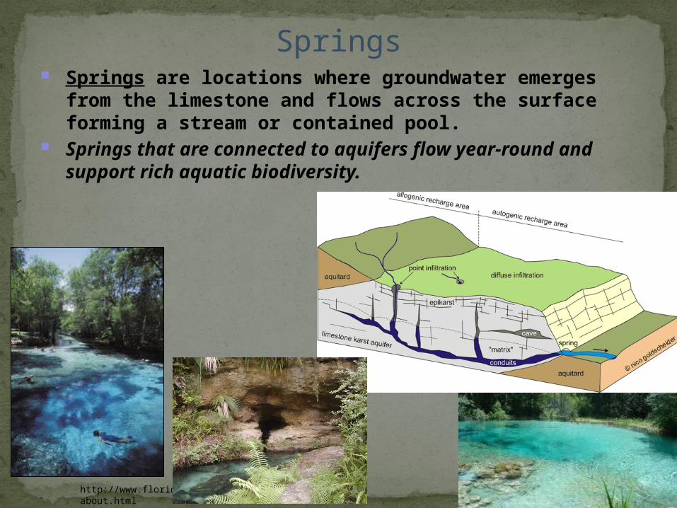
Springs Springs are locations where groundwater emerges
from the limestone and flows across the surface forming a stream or contained pool.
Springs that are connected to aquifers flow year-round and support rich aquatic biodiversity.
http://www.floridasprings.com/about.html

Water Table: Soil is not a solid block. There are spaces between the grains of sediment, filled with air or water. The point where water fills the spaces instead of air is called the water table.
The water table mirrors the shape of the surface terrain, rising and falling with the hills and valleys.

the
Aquifers: water stored underground in cavern and rock systems.

Beaches Coast: (coastline, seashore) where the land meets the
ocean. Beaches are depositional landforms along the coastal
area where sediment is transported and deposited by waves and currents.
Most beaches are dominated by sand-sized quartz grains, and shells or shell fragments.
Photo: SCGS
Beaches often stabilize shorelines by absorbing or deflecting wave and current
energy. During large storms, such as hurricanes, beaches can experience extensive erosion, and it can be years before they are
replenished. Beaches provide numerous recreational activities and are a popular
destination for vacationers.

Dunes Dunes are formed as mounds or ridges of sand
deposits and are then sculpted by the wind. Beach Dunes: are important to protectthe shore from storms and waves erodingaway the land.
25
Barchan Dunes
http://www.nps.gov/archive/grsa/resources/images/lgformat/barchan.jpg
John McCauley, USGS
Wind
Transverse Dunes
John McCauley, USGS
WindWind direction
slip face
Sand avalanche
Dune movement
Table of Contents

Barrier Islands Barrier islands, also referred to as barrier beaches, are
long, narrow, depositional landforms, that form parallel to the coastline and may or may not connect to the mainland. They are the first line of protection against hurricane storm surge.
The landward side of the barrier islands may contain tidal flats, marshes, swamps, lagoons, coastal dunes, and beaches.
Image: NOAA

Continental Shelf and Slope The continental shelf is a submerged extension of the
continental crust that slopes gently outward from the modern shoreline to the deep ocean basin.
On average it extends outward for about 80 kilometers (50 miles) and has an average slope of about 1 degree (2 meters/kilometer or 10 feet/mile).
Ocean floor features including continental shelf and slope. This diagram provides a good illustration of how the shelf is a shallow
extension of the continental crust.
A digital elevation model (DEM) of the continental shelf and slope near Los
Angeles, California.
Source: NASA, Visible Earth

Glacial “U-Shaped” Valleys Glacial valleys are formed by the abrasive action of
glacial ice as it slowly carves a “u-shaped” path through the mountainous valleys.
The Alaska's Woodworth Glacier, on the left is beginning to retreat and expose a glacial
u-shaped valley beneath the melting ice. The Sierra Nevada landscape with Yosemite
Valley pictured below, presently only contains glaciers in the highest elevations,
but many of the prominent u-shaped valleys, reveal past evidence of glacial erosion.
Copyright ©Bruce Molnia, Terra PhotographicsSource: Wikimedia Commons

29Source: Wikimedia Commons
Yosemite Valley is littered with glacial erratics, like the example below, perched on Lambert Dome. This erratic is quite
angular suggesting it was only transported by the glacier for a short
distance or amount of time.
The image above is from a recently deposited glacial erratic. Notice how the
erratic is still perched atop glacial ice, and there is a glacier retreating in the lower right corner of the image. The person in
front of the erratic provides a relative scale for size. Table of Contents
These rocks were deposited by moving glaciers. The glacier froze around them, then moved hundreds of miles to depositThese rocks in place they would not normally be found.

Resources and References
30Table of Contents
Christopherson, R. W. 2004. Elemental Geosystems. 4th Ed. Prentice Hall. Upper Saddle River, New Jersey.
Lutgens, F. K. and E. J. Tarbuck 2003. Essentials of Geology, 8th Ed. Prentice Hall. Upper Saddle River, New Jersey.
Smith, G. A. and Pun, A. 2006. How does Earth Work? Physical Geology and the Process of Science. Prentice Hall. Upper Saddle River, New Jersey.


