37
Coffs Harbour Local Growth Management Strategy 2020 Coffs Harbour to 2040 and beyond. JANUARY 2020
Coffs HarbourLocal Growth Management Strategy 2020 Coffs Harbour to 2040 and beyond.
JANUARY 2020
Coffs Harbour Local Growth Management Strategy
January 2020 © Coffs Harbour City Council
DisclaimerWhilst every reasonable effort has been made to ensure that this document is correct at the time of printing, Coffs Harbour City Council disclaim any and all liability to any person in respect of anything done or omitted to be done in reliance or upon the whole or any part of this document.
Copyright NoticeWith the exception of coats of arms, emblems, other third party material or devices protected by a trademark, the content of this document is licensed under the Creative Commons Australia Attribution 3.0 Licence.We request attribution as: © Coffs Harbour City Council. All other rights are reserved. Coffs Harbour City Council has undertaken reasonable enquiries to identify material owned by third parties and secure permission for its reproduction. A number of images have been supplied by Coast Studios and are reliant on their licencing arrengements. Permission may need to be obtained from third parties to re-use their material.Cover images: © P. Bellingham; G2Architects.
ABBREVIATIONS USED IN THIS PLAN
CSP Community Strategic Plan
LGMS Local Growth Management Strategy
CHCC Coffs Harbour City Council
DPIE Department of Planning, Industry and Environment
LEP Local Environmental Plan
DCP Development Control Plan
LGA Local Government Area
LGMS Local Growth Management Strategy
Actions Endorsed by Department of Planning, Industry and Environment
Chapters 1 - 4 of the Coffs Harbour Local Growth Management Strategy 2020 were adopted by Coffs Harbour City Council on 28 November 2019. The NSW Department of Planning, Industry and Environment (DPIE) endorsed these chapters on 13 January 2020. They are now able to be used by Coffs Harbour City Council for growth work to 2040 and to inform Council's Local Strategic Planning Statement 2020.
In endorsing Chapters 1-4, NSW DPIE advised that their endorsement is subject to detailed assessment of site-specific development constraints for the release areas at the structure plan or planning proposal stage, to confirm the overall suitability of the land for development as well as consistency with relevant State Environmental Planning Policies and Section 9.1 Directions, particularly in relation to issues such environmental value, agricultural significance, land use conflict, hazards, cultural heritage and infrastructure. Only when these investigations have been completed can it be determined whether the identified lands will be appropriate for more intensive development and rezoning.
DPIE further advised that the employment land investigation area post 2040 south of Bonville identified in Chapter 4 is not approved. This area has been excluded as it is inconsistent with the North Coast Regional Plan 2036 urban growth boundaries and is also beyond the scope of Council’s 20-year strategy.
Contents.1. Introduction 1.1 Overview ..........................................................................................1
1.2 Purpose of the Local Growth Management Strategy ..............2
1.3 Context ...........................................................................................2
1.4 Global Tends Influencing Local Responses ..............................8
1.5 Methodology ................................................................................ 12
1.6 Community Consultation ............................................................ 12
2. Supply and Demand Analysis 2.1 Residential Demand Analysis ................................................... 15
2.2 Residential Supply Analysis...................................................... 18
2.3 Balancing Residential Demand and Supply ........................... 19
3. Strategic Approach 3.1 Growth Management Philosophy .............................................. 21
3.2 Vision .......................................................................................... 24
3.3 Placemaking Framework .......................................................... 25
3.4 Directions, Actions and Implementation ................................ 40
4. Compact City Program 4.1 Growth, Infill and Renewal Program ........................................ 45
4.2 Delivery of the Compact City Program .................................. 46
4.3 Future Residential Growth to 2050 .........................................70
4.4 Directions, Actions and Implementation ..................................71
4.5 Resourcing the Compact City Program...................................76
5. Rural Lands SEPARATE CHAPTER ............................................................................
6. Large Lot Residential Lands SEPARATE CHAPTER ............................................................................
7. Residential Lands SEPARATE CHAPTER ............................................................................
8. Employment Lands SEPARATE CHAPTER ............................................................................
9. Resources SEPARATE CHAPTER ......................................................................
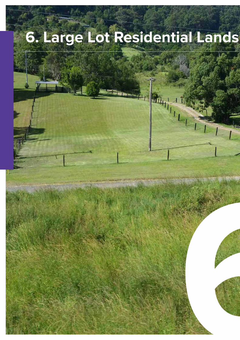
6. Large Lot Residential Lands
6
Chapter 6 Large Lot Residential 1
6. Large Lot Residential Lands
6Executive SummaryThe purpose of this revised and updated Large Lot Residential Lands chapter of the Coffs Harbour Local Growth Management Strategy (LGMS) is to ensure that Council can facilitate the delivery of well-planned large lot residential housing areas that are not located in the coastal strip.
As the region grows over the next twenty years, Council’s aim is to develop well-designed communities that support and enhance the local character, provide active lifestyles and engender current and new residents with an ongoing sense of wellbeing and belonging. Large lot residential land will contribute to the residential lifestyle options available within the LGA and play a part (albeit a minor one) in meeting the housing needs of the Coffs Harbour LGA.
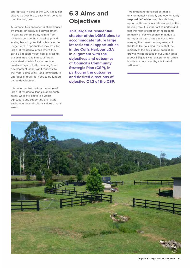
There is, however, also a need for balance and choice in housing opportunities, and Council recognises there is a legitimate demand for rural lifestyle lots that may be appropriate in parts of the Local Government Area (LGA). It may not always be possible to satisfy this demand over the long term.
While rural lifestyle living opportunities remain a relevant part of the housing mix, it is important to understand that this form of settlement represents primarily a ‘lifestyle choice’ that, due to its larger lot size, plays a minor role in meeting the overall housing needs of the Coffs Harbour LGA. Given that the majority of the city’s future population growth will be housed in our urban areas (about 85%), it is vital that potential urban land is not consumed by this form of settlement.
Applying the Compact City approach to large lot residential development might be characterised by smaller lot sizes, infill development in existing zoned areas, hazard-free locations outside the coastal strip, and scaling back of greenfield sites over the longer term. Opportunities may exist for large lot residential areas where they can be adequately serviced by existing or committed road infrastructure at a standard suitable for the predicted level and type of traffic resulting from development, at no significant cost to the wider community. Road infrastructure upgrades (if required) need to be funded by the development. Large lot residential development should not come at the expense of viable agriculture and should support the natural environmental and cultural values of rural areas.
Coffs Harbour LGA has relatively large stocks of unsubdivided land within Zone R5 Large Lot Residential that can supply new land to satisfy legitimate demand for approximately 13.5 years. This land is the short-term supply that can proceed subject to a successful development application for subdivision. However, this land is concentrated at Bonville and Korora. There is a perceived demand for large lot residential opportunities to reinforce the small communities of Nana Glen, Coramba and Karangi. There is also a long history of Council supporting additional large lot residential land at Korora, Moonee and Sapphire west of the Pacific Highway.
This chapter identifies five areas located both east and west of the coastal range (but all west of the Pacific Highway) that should add sufficient land to deliver equilibrium between large lot residential land supply and demand over the life of this strategy.
Collectively, the candidate areas in this chapter could contribute a further 158 lots (approximately) representing about 4.5 years’ supply at average annual demand rates. The objectives of this large lot residential land chapter are to:
• provide a strategic approach to large lot residential development in the LGA in line with state planning strategies and the MyCoffs Community Strategic Plan;
• outline potential future locations and extent of large lot residential development in the LGA beyond existing zoned land and up to 2040; and
• inform other key Council documents that influence or are affected by future land use directions.
This Chapter was reported to Council on 22 August 2019. it has been updated in response to the resolution of that meeting (Resolution Number 2019/126).
2 Coffs Harbour Local Growth Management Strategy To 2040
Chapter 6 Coffs Harbour Local Growth Management Strategy January 2020 © Coffs Harbour City Council
DisclaimerWhilst every reasonable effort has been made to ensure that this document is correct at the time of printing, Coffs Harbour City Council disclaim any and all liability to any person in respect of anything done or omitted to be done in reliance or upon the whole or any part of this document.
Copyright NoticeWith the exception of coats of arms, emblems, other third party material or devices protected by a trademark, the content of this document is licensed under the Creative Commons Australia Attribution 3.0 Licence.We request attribution as: © Coffs Harbour City Council. All other rights are reserved. Coffs Harbour City Council has undertaken reasonable enquiries to identify material owned by third parties and secure permission for its reproduction. A number of images have been supplied by Coast Studios and are reliant on their licencing arrengements. Permission may need to be obtained from third parties to re-use their material.
This Report has been prepared by MikeSvikisPlanning for Coffs Harbour City Council MikeSvikisPlanning
Actions Endorsed by Department of Planning, Industry and Environment
ABBREVIATIONS USED IN THIS PLAN
CSP Community Strategic Plan
LGMS Local Growth Management Strategy
CHCC Coffs Harbour City Council
DPIE Department of Planning, Industry and Environment
LEP Local Environmental Plan
DCP Development Control Plan
LGA Local Government Area
LGMS Local Growth Management Strategy
Chapter 6 of the Coffs Harbour Local Growth Management Strategy 2020 were adopted by Coffs Harbour City Council on 28 November 2019. The NSW Department of Planning, Industry and Environment (DPIE) endorsed this chapter on 13 January 2020. Chapter 6 is now able to be used by Coffs Harbour City Council for growth work to 2040 and to inform Council's Local Strategic Planning Statement 2020.
In endorsing Chapter 6, NSW DPIE advised that their endorsement is subject to detailed assessment of site-specific development constraints for the release areas at the structure plan or planning proposal stage, to confirm the overall suitability of the land for development as well as consistency with relevant State Environmental Planning Policies and Section 9.1 Directions, particularly in relation to issues such environmental value, agricultural significance, land use conflict, hazards, cultural heritage and infrastructure. Only when these investigations have been completed can it be determined whether the identified lands will be appropriate for more intensive development and rezoning.
Chapter 6 Large Lot Residential 3
Executive Summary ....................................................................................................................... 1
6.1 Strategic and Statutory Framework ............................................................................................4
6.2 Vision .............................................................................................................................................4
6.3 Aims and Objectives .....................................................................................................................5
6.4 Supply and Demand Analysis ......................................................................................................6
6.4.1 Large Lot Dwelling Approvals Method ..............................................................................6
6.4.2 Large Lot Subdivision Approvals Method .........................................................................6
6.4.3 Population Growth Method ................................................................................................6
6. 4.4 Large Lot Land Supply .......................................................................................................6
6.4.5 Balancing Demand and Supply ..........................................................................................7
6.5 Constraints, Infrastructure and Services ....................................................................................8
6.5.1 Physical Catchment Assessment .......................................................................................8
6.5.2 Social and Servicing Catchment Assessment ..................................................................9
6.6 Land Use Conflict ........................................................................................................................ 10
6.7 Lot Size ......................................................................................................................................... 11
6.8 User Pays ..................................................................................................................................... 12
6.9 Large Lot Selection Principles ................................................................................................... 12
6.10 Land Release Program .............................................................................................................. 12
6.10.1 Korora, Sapphire and Moonee Beach Candidate Area .................................................. 12
6.10.2 Nana Glen Candidate Areas ............................................................................................ 16
6.10.3 Coramba Candidate Area ................................................................................................ 21
6.10.4 Karangi Candidate Area ................................................................................................. 23
6.10.5 Previously Omitted Bonville Land ..................................................................................27
6.11 Recommendations ..................................................................................................................... 28
6.12 Implementation Direction, Actions and Review ..................................................................... 30
6.12.1 Implementation ................................................................................................................ 30
6.12.2 Monitoring and Review ................................................................................................... 33
6.13 Resourcing Policy Changes ..................................................................................................... 33
Contents.
4 Coffs Harbour Local Growth Management Strategy To 2040
The overarching community vision for the future development of Coffs
Harbour is as articulated in the MyCoffs Community Strategic Plan:
Connected, Sustainable and Thriving
6.1 Strategic and Statutory Framework This Chapter was reported to Council on 22 August 2019. It has been updated in response to the resolution of that meeting (Resolution Number 2019/126).
Council adopted the Coffs Harbour City Rural Residential Strategy in 2009 as part of its Local Growth Management Strategy (LGMS). The 2009 strategy included a two-stage land release program that looked at supplying land to the market over twenty years.
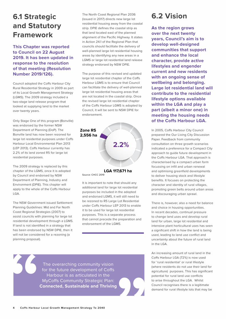
Only Stage One of this program (Bonville) was endorsed by the former NSW Department of Planning (DoP). The Bonville land has now been rezoned for large lot residential purposes under Coffs Harbour Local Environmental Plan 2013 (LEP 2013). Coffs Harbour currently has 2.2% of its land zoned R5 for large lot residential purposes.
The 2009 strategy is replaced by this chapter of the LGMS, once it is adopted by Council and endorsed by NSW Department of Planning, Industry and Environment (DPIE). This chapter will apply to the whole of the Coffs Harbour LGA.
The NSW Government issued Settlement Planning Guidelines: Mid and Far North Coast Regional Strategies (2007) to assist councils with planning for large lot residential development through a LGMS. If land is not identified in a strategy that has been endorsed by NSW DPIE, then it will not be considered for a rezoning (a planning proposal).
The North Coast Regional Plan 2036 (issued in 2017) directs new large lot residential housing away from the coastal strip. DPIE defines the coastal strip as that land located east of the planned alignment of the Pacific Highway. It states in Action 24.1 of the Regional Plan that councils should facilitate the delivery of well-planned large lot residential housing areas by identifying any new areas in a LGMS or large lot residential land release strategy endorsed by NSW DPIE.
The purpose of this revised and updated large lot residential chapter of the Coffs Harbour LGMS is to ensure that Council can facilitate the delivery of well-planned large lot residential housing areas that are not located in the coastal strip. Once the revised large lot residential chapter of the Coffs Harbour LGMS is adopted by Council, it will be sent to NSW DPIE for endorsement.
It is important to note that should any additional land for large lot residential purposes be included in the adopted and endorsed LGMS, it will still need to be rezoned to R5 Large Lot Residential under Coffs Harbour LEP 2013 to enable it to be used for large lot residential purposes. This is a separate process that cannot precede the preparation and endorsement of the LGMS.
6.2 Vision As the region grows over the next twenty years, Council’s aim is to develop well-designed communities that support and enhance the local character, provide active lifestyles and engender current and new residents with an ongoing sense of wellbeing and belonging. Large lot residential land will contribute to the residential lifestyle options available within the LGA and play a part (albeit a minor one) in meeting the housing needs of the Coffs Harbour LGA.
In 2005, Coffs Harbour City Council prepared the Our Living City Discussion Paper. Feedback from community consultation on three growth scenarios indicated a preference for a Compact City approach to guide future development in the Coffs Harbour LGA. That approach is characterised by a compact urban form focussing on infill and urban renewal and optimising greenfield developments to deliver housing stock and lifestyle benefits. It focuses on protecting the character and identity of rural villages, promoting green belts around urban areas and discouraging urban sprawl.
There is, however, also a need for balance and choice in housing opportunities. In recent decades, continual pressure to change land uses and develop rural land for urban, large lot residential and intensive plant horticultural uses has seen a significant shift in how the land is being used, leading to land use conflict and uncertainty about the future of rural land in the LGA.
An increasing amount of rural land in the Coffs Harbour LGA (72%) is now used for ‘rural residential’ or rural lifestyle (where residents do not use their land for agriculture) purposes. This has significant potential for rural land use conflicts to arise throughout the LGA. Whilst Council recognises there is a legitimate demand for rural lifestyle lots that may be
2.2%
LGA 117,671 ha
Zone R52,556 ha
Source: CHCC 2019
Chapter 6 Large Lot Residential 5
appropriate in parts of the LGA. it may not always be possible to satisfy this demand over the long term.
A Compact City approach is characterised by smaller lot sizes, infill development in existing zoned areas, hazard-free locations outside the coastal strip, and scaling back of greenfield sites over the longer term. Opportunities may exist for large lot residential areas where they can be adequately serviced by existing or committed road infrastructure at a standard suitable for the predicted level and type of traffic resulting from development, at no significant cost to the wider community. Road infrastructure upgrades (if required) need to be funded by the development.
It is important to consider the future of large lot residential lands in appropriate areas, while still delivering viable agriculture and supporting the natural environmental and cultural values of rural areas.
6.3 Aims and ObjectivesThis large lot residential chapter of the LGMS aims to accommodate future large lot residential opportunities in the Coffs Harbour LGA in alignment with the objectives and outcomes of Council’s Community Strategic Plan (CSP), in particular the outcomes and desired directions of objective C1.2 of the CSP:
“We undertake development that is environmentally, socially and economically responsible”. While rural lifestyle living opportunities remain a relevant part of the housing mix, it is important to understand that this form of settlement represents primarily a ‘lifestyle choice’ that, due to its larger lot size, plays a minor role in meeting the overall housing needs of the Coffs Harbour LGA. Given that the majority of the city’s future population growth will be housed in our urban areas (about 85%), it is vital that potential urban land is not consumed by this form of settlement.
6 Coffs Harbour Local Growth Management Strategy To 2040
6.4 Supply and Demand Analysis Large lot residential demand can be estimated using a variety of methods, with each having merit. The outcomes of each are influenced by the assumptions made, and these need to be stated. The three methods included in this LGMS are large lot dwelling approvals, large lot subdivision approvals and a population growth method.
The supply of land to meet future large lot residential demand will come from a combination of sources:• vacant subdivided lots within existing
R5 Large Lot Residential zoned land;
• R5 Large Lot Residential zoned land that is yet to be subdivided; and
• new “greenfield” sites that are not yet zoned R5 Large Lot Residential and are in this LGMS (and are endorsed by the Department of Planning, Industry and Environment).
6.4.1 Large Lot Dwelling Approvals Method
This approach identifies the number of large lot residential dwelling approvals over a set period such as the previous five years to give an annual average, and then projects that forward over a given timeframe to provide an estimate of future demand. The former North Coast Regional Environmental Plan (DoP, 1988) suggested that an additional 30% can be added to the projected dwelling demand to account for the difficulty in accurately predicting demand and the need to account for how past constraints on lot supply can impact on the rate of dwelling approvals.
Over the last five years, Council has approved approximately 107 dwellings on land within zone R5 Large Lot Residential. That is an average of 21.4 dwellings per year or 28 dwellings per year inclusive of an additional 30%.
6.4.2 Large Lot Subdivision Approvals Method
This approach identifies the number of large lot residential allotments produced over a set period such as the previous five years to give an annual average, and then projects that forward over a given timeframe to provide an estimate of future demand. The North Coast Regional Environmental Plan (DoP, 1988) suggested that an additional 30% can be added to the projected lot demand to account for the difficulty in accurately predicting demand and the need to account for how past constraints on the amount and location of zoned land can impact on the rate of lot production.
Over the last five years, Council has approved approximately 150 lots on land within zone R5 Large Lot Residential. That is an average of 30 lots per year or 39 lots per year inclusive of an additional 30%.
6.4.3 Population Growth Method
Another approach is to assess the proportion of large lot residential dwelling approvals against overall dwelling approvals over a set period such as the previous five years. This can then be used to estimate the percentage of the overall predicted demand for dwellings based on projected population growth that would be taken up by large lot residential dwellings.
Over the last five years, Council has approved approximately 1,180 dwellings in its residential and large lot residential zones (not counting secondary dwellings or medium density housing). Approximately 107 of these were on land within zone R5 Large Lot Residential. This represents 9% of approved dwellings. Based on population forecasts (from 2016 to 2040),
Coffs Harbour will need between 10,650 and 13,267 new dwellings to meet projected growth over this twenty-year period. This is an average of between 444 and 497 dwellings per year. Assuming that 40% of these are in some form of medium density housing then that leaves between
266 and 298 as dwelling houses. If 9% of these were in a R5 zone then demand would equate to between 24 and 26 large lot residential dwellings per year, on average, over the long term.
6.4.4 Large Lot Land Supply
Vacant Subdivided R5 Lots
In some cases where significant areas of land within zone R5 Large Lot Residential have been subdivided and remain available on the market for purchase, it is appropriate to account for this land specifically in estimating land supply.
An analysis of land within zone R5 Large Lot Residential indicates there are no significant registered large lot subdivisions being held back from the market. Recent trends in land subdivision suggest that developers are creating lots in smaller stages than in the past in order to minimise the upfront infrastructure costs (particularly roads, electricity, etc). This means that smaller numbers of vacant lots exist at any one time and the numbers change rapidly over time. It is assumed that there will always be some vacant lots available, but this number is not that significant. Vacant subdivided lots have been discounted from the supply assessment.
Vacant Unsubdivided R5 Lots
Existing land within zone R5 Large Lot Residential has been assessed for its subdivision potential. An important aspect of the review of supply has been to assess if any land within the zone is not delivering significant lots to the market.
These sites give the impression that Council has plenty of land that could be supplied to the market but it does not get there for a variety of reasons. Those reasons may be the physical characteristics of the land, the cost of development or just that owners are not currently interested in developing the land. It is appropriate that these areas be discounted from the supply estimates. Discounting is not back-zoning and, if
Chapter 6 Large Lot Residential 7
circumstances change, development may occur.
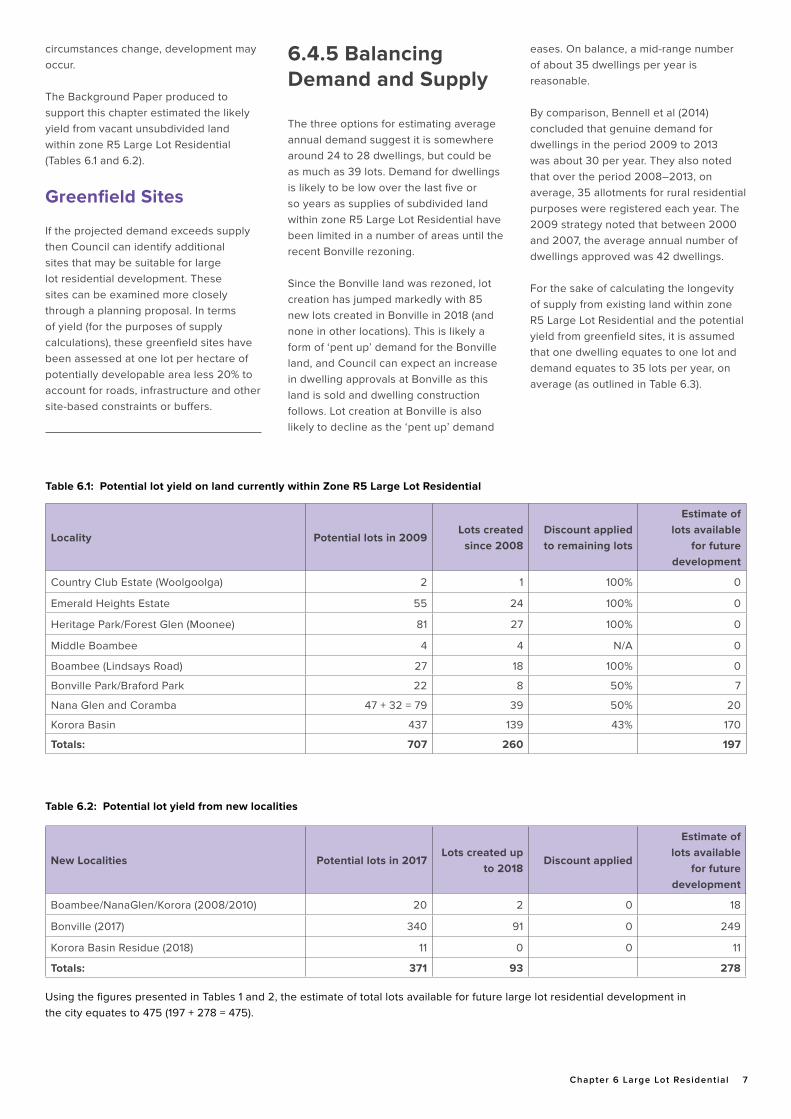
The Background Paper produced to support this chapter estimated the likely yield from vacant unsubdivided land within zone R5 Large Lot Residential (Tables 6.1 and 6.2).
Greenfield Sites
If the projected demand exceeds supply then Council can identify additional sites that may be suitable for large lot residential development. These sites can be examined more closely through a planning proposal. In terms of yield (for the purposes of supply calculations), these greenfield sites have been assessed at one lot per hectare of potentially developable area less 20% to account for roads, infrastructure and other site-based constraints or buffers.
Locality Potential lots in 2009Lots created
since 2008Discount applied to remaining lots
Estimate of lots available
for future development
Country Club Estate (Woolgoolga) 2 1 100% 0
Emerald Heights Estate 55 24 100% 0
Heritage Park/Forest Glen (Moonee) 81 27 100% 0
Middle Boambee 4 4 N/A 0
Boambee (Lindsays Road) 27 18 100% 0
Bonville Park/Braford Park 22 8 50% 7
Nana Glen and Coramba 47 + 32 = 79 39 50% 20
Korora Basin 437 139 43% 170
Totals: 707 260 197
Table 6.1: Potential lot yield on land currently within Zone R5 Large Lot Residential
New Localities Potential lots in 2017Lots created up
to 2018Discount applied
Estimate of lots available
for future development
Boambee/NanaGlen/Korora (2008/2010) 20 2 0 18
Bonville (2017) 340 91 0 249
Korora Basin Residue (2018) 11 0 0 11
Totals: 371 93 278
Table 6.2: Potential lot yield from new localities
Using the figures presented in Tables 1 and 2, the estimate of total lots available for future large lot residential development in the city equates to 475 (197 + 278 = 475).
6.4.5 Balancing Demand and Supply
The three options for estimating average annual demand suggest it is somewhere around 24 to 28 dwellings, but could be as much as 39 lots. Demand for dwellings is likely to be low over the last five or so years as supplies of subdivided land within zone R5 Large Lot Residential have been limited in a number of areas until the recent Bonville rezoning.
Since the Bonville land was rezoned, lot creation has jumped markedly with 85 new lots created in Bonville in 2018 (and none in other locations). This is likely a form of ‘pent up’ demand for the Bonville land, and Council can expect an increase in dwelling approvals at Bonville as this land is sold and dwelling construction follows. Lot creation at Bonville is also likely to decline as the ‘pent up’ demand
eases. On balance, a mid-range number of about 35 dwellings per year is reasonable.
By comparison, Bennell et al (2014) concluded that genuine demand for dwellings in the period 2009 to 2013 was about 30 per year. They also noted that over the period 2008–2013, on average, 35 allotments for rural residential purposes were registered each year. The 2009 strategy noted that between 2000 and 2007, the average annual number of dwellings approved was 42 dwellings.
For the sake of calculating the longevity of supply from existing land within zone R5 Large Lot Residential and the potential yield from greenfield sites, it is assumed that one dwelling equates to one lot and demand equates to 35 lots per year, on average (as outlined in Table 6.3).
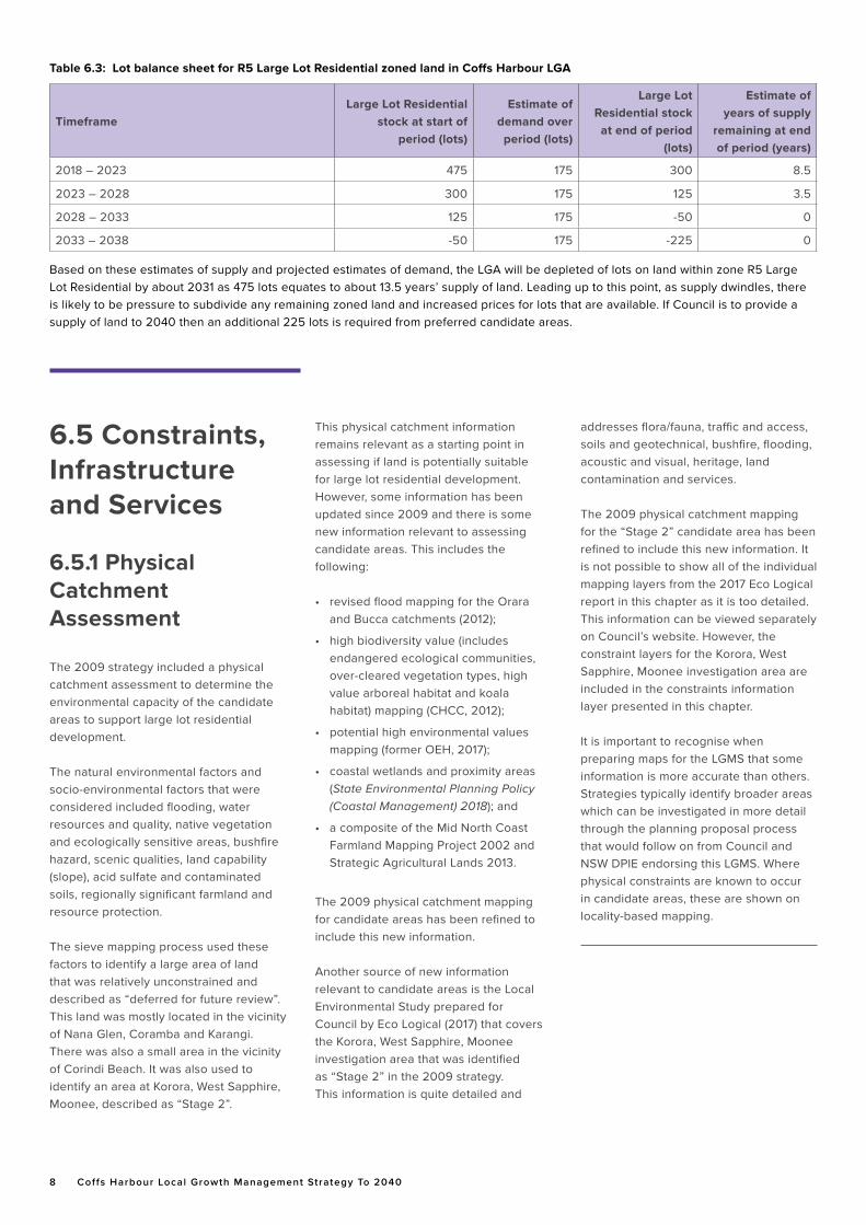
8 Coffs Harbour Local Growth Management Strategy To 2040
TimeframeLarge Lot Residential
stock at start of period (lots)
Estimate of demand over
period (lots)
Large Lot Residential stock
at end of period (lots)
Estimate of years of supply
remaining at end of period (years)
2018 – 2023 475 175 300 8.5
2023 – 2028 300 175 125 3.5
2028 – 2033 125 175 -50 0
2033 – 2038 -50 175 -225 0
Table 6.3: Lot balance sheet for R5 Large Lot Residential zoned land in Coffs Harbour LGA
Based on these estimates of supply and projected estimates of demand, the LGA will be depleted of lots on land within zone R5 Large Lot Residential by about 2031 as 475 lots equates to about 13.5 years’ supply of land. Leading up to this point, as supply dwindles, there is likely to be pressure to subdivide any remaining zoned land and increased prices for lots that are available. If Council is to provide a supply of land to 2040 then an additional 225 lots is required from preferred candidate areas.
6.5 Constraints, Infrastructure and Services
6.5.1 Physical Catchment Assessment
The 2009 strategy included a physical catchment assessment to determine the environmental capacity of the candidate areas to support large lot residential development.
The natural environmental factors and socio-environmental factors that were considered included flooding, water resources and quality, native vegetation and ecologically sensitive areas, bushfire hazard, scenic qualities, land capability (slope), acid sulfate and contaminated soils, regionally significant farmland and resource protection.
The sieve mapping process used these factors to identify a large area of land that was relatively unconstrained and described as “deferred for future review”. This land was mostly located in the vicinity of Nana Glen, Coramba and Karangi. There was also a small area in the vicinity of Corindi Beach. It was also used to identify an area at Korora, West Sapphire, Moonee, described as “Stage 2”.
This physical catchment information remains relevant as a starting point in assessing if land is potentially suitable for large lot residential development. However, some information has been updated since 2009 and there is some new information relevant to assessing candidate areas. This includes the following:
• revised flood mapping for the Orara and Bucca catchments (2012);
• high biodiversity value (includes endangered ecological communities, over-cleared vegetation types, high value arboreal habitat and koala habitat) mapping (CHCC, 2012);
• potential high environmental values mapping (former OEH, 2017);
• coastal wetlands and proximity areas (State Environmental Planning Policy (Coastal Management) 2018); and
• a composite of the Mid North Coast Farmland Mapping Project 2002 and Strategic Agricultural Lands 2013.
The 2009 physical catchment mapping for candidate areas has been refined to include this new information.
Another source of new information relevant to candidate areas is the Local Environmental Study prepared for Council by Eco Logical (2017) that covers the Korora, West Sapphire, Moonee investigation area that was identified as “Stage 2” in the 2009 strategy. This information is quite detailed and
addresses flora/fauna, traffic and access, soils and geotechnical, bushfire, flooding, acoustic and visual, heritage, land contamination and services.
The 2009 physical catchment mapping for the “Stage 2” candidate area has been refined to include this new information. It is not possible to show all of the individual mapping layers from the 2017 Eco Logical report in this chapter as it is too detailed. This information can be viewed separately on Council’s website. However, the constraint layers for the Korora, West Sapphire, Moonee investigation area are included in the constraints information layer presented in this chapter.
It is important to recognise when preparing maps for the LGMS that some information is more accurate than others. Strategies typically identify broader areas which can be investigated in more detail through the planning proposal process that would follow on from Council and NSW DPIE endorsing this LGMS. Where physical constraints are known to occur in candidate areas, these are shown on locality-based mapping.
Chapter 6 Large Lot Residential 9
6.5.2 Social and Servicing Catchment Assessment
The 2009 strategy included a social and servicing catchment assessment to ensure that candidate areas identified to support large lot residential development.
This assessment required that candidate areas:• are consistent with projected
population changes;
• take into account the social and community services available to be provided to the community; and
• do not result in development that will exceed the carrying capacity of service infrastructure.
It assessed population growth and age structure; education, health and emergency facilities; urban expansion areas; road network; shopping; Aboriginal cultural heritage; and feedback from community consultation.
The 2009 strategy noted that most
community facilities and services are
located in urban areas where they serve a
larger proportion of the population. Given
that large lot residential areas are typically
distant from urban centres, reduced
access to many of the services located in
these urban centres can be problematic.
As the private car will remain the
predominant form of transport for large
lot residential households, the capacity of
the road network will present a significant
factor in determining the best location for
large lot residential development.
From a strategic planning perspective, the
closer large lot residential development
is able to be located to the nearest
urban centre, the greater the range of
accessibility benefits such as reduced
journeys to work, school, shopping,
services, recreation and the like. This
leads to lower greenhouse gas emissions,
less impact on roads and less congestion
and associated vehicular impacts. This
supports objective C1.2 of the MyCoffs
Community Strategic Plan: “We undertake
development that is environmentally,
socially and economically responsible”.
The 2009 social and servicing catchment information remains relevant in assessing land that is potentially suitable for large lot residential development. However, some information has been updated since 2009 and there is some new information relevant to assessing candidate areas. This includes the following:
• Current road access quality assessments• Revised Pacific Highway alignment• High Speed Rail corridor options• 132 kV electricity transmission line corridor• Updated Aboriginal heritage site records (AHIMS) and Aboriginal cultural heritage values1
Four other social and servicing factors that have been used to assess the suitability of land for large lot residential development are:
• Distance to the nearest primary school• Multiple land ownership/locations (creates competition)• Proximity to existing or proposed large lot residential areas (clustering to make better use of services)• Interest from land owners in proceeding with a planning proposal and subdivision (to minimise land banking)• Prospective lot yield of ten or more lots (to spread development costs).
The 2009 social and servicing catchment mapping for the “deferred for future review” candidate areas has been refined to include this new information.
1 At the time of preparing this chapter, cultural heritage mapping was not available to the public and cannot be shown in locality mapping in this chapter. It has been considered and remains a factor requiring further assessment if a planning proposal for any locality is contemplated.
10 Coffs Harbour Local Growth Management Strategy To 2040
Residential. The primary objective of the Large Lot Residential Zone is to provide residential housing in a rural setting while preserving, and minimising impacts on environmentally sensitive locations and scenic quality. Supporting this, is the objective to minimise land use conflicts within this zone and adjoining zones.
It is considered appropriate that local planning controls be amended to remove landuses that do not accord with the objectives of Zone R5 Large Lot Residential. This would provide greater certainty for the community and rural landholders to manage future land use conflicts, and uphold the residential objectives of the zone.
Submissions made to draft Chapter 6 – Large Lot Residential Lands of the LGMS and community feedback received during community consultation activities associated with Council’s review of its LGMS relate to significant land use conflict issues between Large Lot Residential uses and Horticulture (in particular Intensive Plant Agriculture). Community feedback received by Council on an Intensive Plant Agriculture Discussion Paper which was publicly exhibited in 2019 also identified significant land use conflict issues between Large Lot Residential uses and Intensive Plant Agriculture.
Recent studies undertaken by Coffs Harbour City Council and Southern Cross University have verified many of the land use conflict issues reported by the wider community in relation to Intensive Plant Agriculture. These issues are more pronounced in large lot residential areas due to the close proximity of dwellings to Intensive Plant Agriculture. Frequent issues relate to pesticide spray drift, impacts on water quality, noise, worker’s accommodation, traffic and parking, waste
management, chemical use, storage and handling, land contamination, sediment and erosion control, native vegetation loss, burning and water extraction and storage. The degree of land use conflict associated with Intensive Plant Agriculture and large lot residential land use is also highlighted as an issue for Coffs Harbour in the 2018 report by the University of Technology Sydney, ‘Right to Farm - Agricultural Land Use Survey: Final Report.’
Based on the issues raised by submissions made to draft Chapter 6 – Large Lot Residential and broader community feedback on this matter, it has been determined that Horticulture is potentially in conflict with the objectives of Zone R5 Large Lot Residential, which is to provide residential housing in a rural setting while preserving and minimising impacts on environmentally sensitive locations and scenic qualities.
This matter was reported to Council on 22 August 2019, at which time it was resolved that Council retain the existing requirement for Horticulture on land within zone R5 Large Lot Residential of Coffs Harbour LEP 2013 (that is, requiring development consent).
Council will undertake a review of other existing permissible land uses within Zone R5 Large Lot Residential to ensure that they are consistent with the objectives of the zone.
Chapter 6 – Large Lot Residential of the LGMS includes an action to determine whether any lands currently zoned R5 Large Lot Residential (and predominantly used extensively for horticultural uses) are more suited to an RU4 Primary Production Small Lots zoning.
6.6 Land Use ConflictIn recent decades, continual pressure to change land uses and develop rural land for urban, rural lifestyle, large lot residential and intensive plant agricultural uses has seen an increase in land use conflict and uncertainty about the future of rural land in the LGA.
The presence of agriculture and non-rural land uses in the one location can generate conflict due to their potential incompatibility. This is particularly evident with intensive plant agriculture. Issues of conflicts have been raised in relation to waste, noise, chemical and water pollution, and the need for buffers, from nearby agricultural activities on neighbouring large lot residential land uses. Between 2017 and 2019 Council prepared an Intensive Plant Agriculture Discussion Paper to inform Chapter 5 - Rural Lands of the Coffs Harbour Local Growth Management Strategy. The Discussion Paper explored options to minimise impacts specific to this type of land use relating to Zone RU2 Rural Landscape and on surrounding land uses. The Intensive Plant Agriculture Discussion Paper has been finalised and forms an appendix D of Chapter 5 of this Strategy.
Coffs Harbour Local Environmental Plan (LEP) 2013 provides objective and categories of permissible development for land uses within Zone R5 Large Lot
A lot size for any R5 location will need to be consistent with the objectives of the R5 Large Lot Residential zone of Coffs Harbour LEP 2013 as follows:
• To provide residential housing in a rural setting while preserving, and minimising impacts on, environmentally sensitive locations and scenic quality.
• To ensure that large residential lots do not hinder the proper and orderly development of urban areas in the future.
• To ensure that development in the area does not unreasonably increase the demand for public services or public facilities.
• To minimise conflict between land uses within this zone and land uses within adjoining zones.
Chapter 6 Large Lot Residential 11
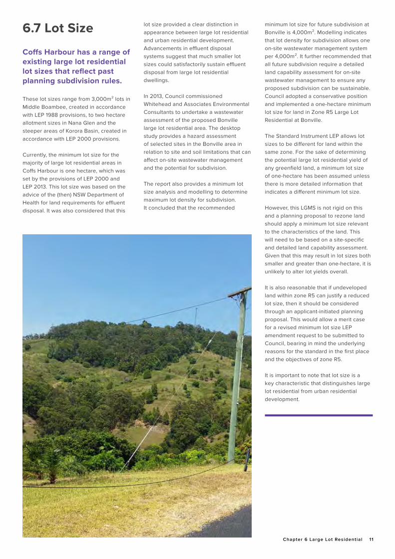
6.7 Lot Size
Coffs Harbour has a range of existing large lot residential lot sizes that reflect past planning subdivision rules.
These lot sizes range from 3,000m² lots in Middle Boambee, created in accordance with LEP 1988 provisions, to two hectare allotment sizes in Nana Glen and the steeper areas of Korora Basin, created in accordance with LEP 2000 provisions.
Currently, the minimum lot size for the majority of large lot residential areas in Coffs Harbour is one hectare, which was set by the provisions of LEP 2000 and LEP 2013. This lot size was based on the advice of the (then) NSW Department of Health for land requirements for effluent disposal. It was also considered that this
lot size provided a clear distinction in appearance between large lot residential and urban residential development. Advancements in effluent disposal systems suggest that much smaller lot sizes could satisfactorily sustain effluent disposal from large lot residential dwellings.
In 2013, Council commissioned Whitehead and Associates Environmental Consultants to undertake a wastewater assessment of the proposed Bonville large lot residential area. The desktop study provides a hazard assessment of selected sites in the Bonville area in relation to site and soil limitations that can affect on-site wastewater management and the potential for subdivision.
The report also provides a minimum lot size analysis and modelling to determine maximum lot density for subdivision. It concluded that the recommended
minimum lot size for future subdivision at Bonville is 4,000m². Modelling indicates that lot density for subdivision allows one on-site wastewater management system per 4,000m². It further recommended that all future subdivision require a detailed land capability assessment for on-site wastewater management to ensure any proposed subdivision can be sustainable. Council adopted a conservative position and implemented a one-hectare minimum lot size for land in Zone R5 Large Lot Residential at Bonville.
The Standard Instrument LEP allows lot sizes to be different for land within the same zone. For the sake of determining the potential large lot residential yield of any greenfield land, a minimum lot size of one-hectare has been assumed unless there is more detailed information that indicates a different minimum lot size.
However, this LGMS is not rigid on this and a planning proposal to rezone land should apply a minimum lot size relevant to the characteristics of the land. This will need to be based on a site-specific and detailed land capability assessment. Given that this may result in lot sizes both smaller and greater than one-hectare, it is unlikely to alter lot yields overall.
It is also reasonable that if undeveloped land within zone R5 can justify a reduced lot size, then it should be considered through an applicant-initiated planning proposal. This would allow a merit case for a revised minimum lot size LEP amendment request to be submitted to Council, bearing in mind the underlying reasons for the standard in the first place and the objectives of zone R5.
It is important to note that lot size is a key characteristic that distinguishes large lot residential from urban residential development.
12 Coffs Harbour Local Growth Management Strategy To 2040
2 To 7 These principles are consistent with the settlement planning principles for rural residential development identified in Settlement Planning Guidelines (Department of Planning , 2007).
6.9 Large Lot Selection Principles The principles on which the greenfield large lot residential sites in this chapter are selected are substantially the same as those which influenced the 2009 strategy:
• Strengthen the hierarchy of existing settlements in the LGA.2
• Located close to existing centres (within two kilometres).3
• Located away from areas that may, in the future, be needed for urban expansion.4
• Future large lot residential development should be clustered with existing large lot residential areas to encourage a sense of community and for the efficient provision of services and access to higher order services.5
• Fragmented development over the landscape will not be permitted.6
• Located away from regionally significant farmland and intensive plant agriculture areas to minimise conflict.7
• Located on land with few environmental or cultural constraints including High Environmental Value lands, High Aboriginal Cultural Heritage Value lands and land subject to hazards.
• Located with frontage to class 1 or 2 sealed roads (or roads capable of that classification at minimal cost to Council).
• Large lot residential development will not be permitted east of the Pacific Highway alignment.
• Large lot residential development will not be permitted in the Eastern Dorrigo locality (Lowanna and Ulong).
• Provide sufficient land release to deliver equilibrium between land supply and demand.
• Land owners have some interest in proceeding with a planning proposal to enable lots to be created.
• Prospective lot yield of ten or more lots.
6.10 Land Release ProgramA land release program is required to guide the location of future large lot residential development over the next twenty years. The identification of potential candidate areas ensures that future opportunities are located and linked to enable efficient infrastructure provision and to build on the existing settlement patterns of our rural areas.
The following section identifies five areas located both east and west of the coastal range, but west of the Pacific Highway that should add sufficient land to deliver equilibrium between large lot residential land supply and demand over the life of this LGMS chapter.
6.10.1 Korora, Sapphire and Moonee Candidate Area
This area correlates approximately with the area nominated as Stage 2 in the 2009 strategy. Council has undertaken detailed studies of this area resulting in it originally being considered as five precincts as follows:
• Precinct 1 – Korora Basin. On 10 November 2016, Council resolved to progress a Planning Proposal for residual land within the Korora Basin to be zoned R5 Large Lot Residential. This has now been finalised. It has an estimated lot yield of eleven;
• Precinct 2 – Tiki Road. On 10 November 2016, Council resolved not to proceed with the rezoning of any land within Precinct 2 due to prevailing environmental constraints;
• Precinct 3 – Maccues Road;
6.8 User PaysLarge lot residential development does not generally require the same level of reticulated services, eg water and sewerage, as urban development.
In some cases, subdivision can be undertaken as a Community Title subdivision, which allows for sharing of some services between land owners, eg some access roads. Communications and energy are the responsibility of the developer. Water and wastewater are the responsibility of future land owners.
However, Council does expect that when land is rezoned to permit large lot residential development, all public access roads and intersections are to be upgraded to a standard consistent with Council’s development specifications. The cost of infrastructure improvements to bring roads and intersections up to standard should be met by individuals who seek to subdivide their property and not by Council. Council will expect a voluntary planning agreement to ensure that road infrastructure does not become a burden on Council. Depending on the circumstances, agreements may involve multiple land owners. It may also require reimbursement of other costs, eg environmental studies, etc.
Assuming that land identified in this Strategy is to proceed by way of planning proposals on a precinct or proponent basis, then Council will also expect its costs for processing these planning proposals to be provided by the proponent (in accordance with Council’s adopted fees and charges). The user pays principle will be applied.
Chapter 6 Large Lot Residential 13
• Precinct 4 – Wakelands Road/Fairview Road/Sugarmill Road; and
• Precinct 5 – Gaudrons Road/The Mountain Way.
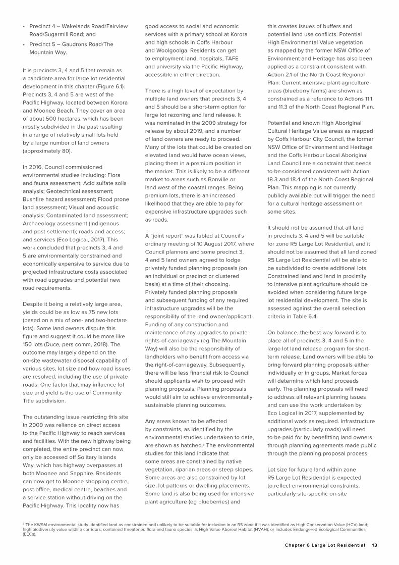
It is precincts 3, 4 and 5 that remain as a candidate area for large lot residential development in this chapter (Figure 6.1).Precincts 3, 4 and 5 are west of the Pacific Highway, located between Korora and Moonee Beach. They cover an area of about 500 hectares, which has been mostly subdivided in the past resulting in a range of relatively small lots held by a large number of land owners (approximately 80).
In 2016, Council commissioned environmental studies including: Flora and fauna assessment; Acid sulfate soils analysis; Geotechnical assessment; Bushfire hazard assessment; Flood prone land assessment; Visual and acoustic analysis; Contaminated land assessment; Archaeology assessment (Indigenous and post-settlement); roads and access; and services (Eco Logical, 2017). This work concluded that precincts 3, 4 and 5 are environmentally constrained and economically expensive to service due to projected infrastructure costs associated with road upgrades and potential new road requirements.
Despite it being a relatively large area, yields could be as low as 75 new lots (based on a mix of one- and two-hectare lots). Some land owners dispute this figure and suggest it could be more like 150 lots (Duce, pers comm, 2018). The outcome may largely depend on the on-site wastewater disposal capability of various sites, lot size and how road issues are resolved, including the use of private roads. One factor that may influence lot size and yield is the use of Community Title subdivision.
The outstanding issue restricting this site in 2009 was reliance on direct access to the Pacific Highway to reach services and facilities. With the new highway being completed, the entire precinct can now only be accessed off Solitary Islands Way, which has highway overpasses at both Moonee and Sapphire. Residents can now get to Moonee shopping centre, post office, medical centre, beaches and a service station without driving on the Pacific Highway. This locality now has
8 The KWSM environmental study identified land as constrained and unlikely to be suitable for inclusion in an R5 zone if it was identified as High Conservation Value (HCV) land; high biodiversity value wildlife corridors; contained threatened flora and fauna species; is High Value Aboreal Habitat (HVAH); or includes Endangered Ecological Communities (EECs).
good access to social and economic services with a primary school at Korora and high schools in Coffs Harbour and Woolgoolga. Residents can get to employment land, hospitals, TAFE and university via the Pacific Highway, accessible in either direction.
There is a high level of expectation by multiple land owners that precincts 3, 4 and 5 should be a short-term option for large lot rezoning and land release. It was nominated in the 2009 strategy for release by about 2019, and a number of land owners are ready to proceed. Many of the lots that could be created on elevated land would have ocean views, placing them in a premium position in the market. This is likely to be a different market to areas such as Bonville or land west of the coastal ranges. Being premium lots, there is an increased likelihood that they are able to pay for expensive infrastructure upgrades such as roads.
A “joint report” was tabled at Council's ordinary meeting of 10 August 2017, where Council planners and some precinct 3, 4 and 5 land owners agreed to lodge privately funded planning proposals (on an individual or precinct or clustered basis) at a time of their choosing. Privately funded planning proposals and subsequent funding of any required infrastructure upgrades will be the responsibility of the land owner/applicant. Funding of any construction and maintenance of any upgrades to private rights-of-carriageway (eg The Mountain Way) will also be the responsibility of landholders who benefit from access via the right-of-carriageway. Subsequently, there will be less financial risk to Council should applicants wish to proceed with planning proposals. Planning proposals would still aim to achieve environmentally sustainable planning outcomes.
Any areas known to be affected by constraints, as identified by the environmental studies undertaken to date, are shown as hatched.8 The environmental studies for this land indicate that some areas are constrained by native vegetation, riparian areas or steep slopes. Some areas are also constrained by lot size, lot patterns or dwelling placements. Some land is also being used for intensive plant agriculture (eg blueberries) and
this creates issues of buffers and potential land use conflicts. Potential High Environmental Value vegetation as mapped by the former NSW Office of Environment and Heritage has also been applied as a constraint consistent with Action 2.1 of the North Coast Regional Plan. Current intensive plant agriculture areas (blueberry farms) are shown as constrained as a reference to Actions 11.1 and 11.3 of the North Coast Regional Plan.
Potential and known High Aboriginal Cultural Heritage Value areas as mapped by Coffs Harbour City Council, the former NSW Office of Environment and Heritage and the Coffs Harbour Local Aboriginal Land Council are a constraint that needs to be considered consistent with Action 18.3 and 18.4 of the North Coast Regional Plan. This mapping is not currently publicly available but will trigger the need for a cultural heritage assessment on some sites.
It should not be assumed that all land in precincts 3, 4 and 5 will be suitable for zone R5 Large Lot Residential, and it should not be assumed that all land zoned R5 Large Lot Residential will be able to be subdivided to create additional lots. Constrained land and land in proximity to intensive plant agriculture should be avoided when considering future large lot residential development. The site is assessed against the overall selection criteria in Table 6.4.
On balance, the best way forward is to place all of precincts 3, 4 and 5 in the large lot land release program for short-term release. Land owners will be able to bring forward planning proposals either individually or in groups. Market forces will determine which land proceeds early. The planning proposals will need to address all relevant planning issues and can use the work undertaken by Eco Logical in 2017, supplemented by additional work as required. Infrastructure upgrades (particularly roads) will need to be paid for by benefitting land owners through planning agreements made public through the planning proposal process.
Lot size for future land within zone R5 Large Lot Residential is expected to reflect environmental constraints, particularly site-specific on-site
14 Coffs Harbour Local Growth Management Strategy To 2040
Assessment criteriaYes | No |
PartlyComment
Strengthen the hierarchy of existing settlements in the LGA.
YesFuture residents will relate to northern beach areas such as Korora, Sapphire and Moonee Beach.
Located close to existing centres (within 2 km). PartlyThe northern precinct is less than 1 km from Moonee Beach commercial centre. The southern precinct is about 6 km north of Coffs Harbour (Park Beach Plaza).
Located away from areas that may, in the future, be needed for urban expansion.
YesThis site is not an urban expansion area. It does not have access to reticulated water and sewerage.
Future large lot residential development should be clustered with existing large lot residential areas to encourage a sense of community and for the efficient provision of services and access to higher order services.
YesThe area abuts land within zone R5 Large Lot Residential at its southern boundary and is an extension of this area.
Located away from regionally significant farmland and intensive plant agriculture areas to minimise conflict.
Partly
This site does not include regionally significant farmland but some parts of it are north facing and used for intensive plant agriculture. Avoiding conflict with intensive plant agriculture (eg blueberries) is an issue to be addressed by planning proposals.
Located on land with few environmental or cultural constraints including potential High Environmental Value lands, High Aboriginal Cultural Heritage Value lands and land subject to hazards.
Partly
The site does have some constraints (eg HEV, steep slopes) and these have been documented in the environmental studies undertaken so far. It is also affected by known and potential High Aboriginal Cultural Heritage values mapping and this will need to be addressed by planning proposals.
Located with frontage to class 1 or 2 sealed roads (or roads capable of that classification at minimal cost to Council).
Partly
Local roads are in various condition, with some needing significant work. Ensuring roads are capable of upgrades to meet agreed standards will be a key factor in lot yield. This will require private funding by those creating lots.
Large lot residential development will not be permitted east of the Pacific Highway alignment.
YesThe land is west of the Pacific Highway in its upgraded alignment.
Large lot residential development will not be permitted in the Eastern Dorrigo locality (Lowanna and Ulong).
Yes The land is not in the Eastern Dorrigo locality.
Provide sufficient land release to deliver equilibrium between land supply and demand.
Yes The land will add about 75 lots to the existing supply.
Land owners have some interest in proceeding with a planning proposal to enable lots to be created.
YesMany land owners have been vocal in support of inclusion in this chapter of the LGMS and proceeding with rezoning of the land.
Prospective lot yield of ten or more lots. YesIndividual properties may yield less than 10 lots due to past subdivision, but each of the precincts will yield considerably more.
Table 6.4: Site selection criteria assessment of Korora, Sapphire and Moonee Beach candidate area
wastewater studies, if lot sizes less than one-hectare are proposed. The Korora, Sapphire and Moonee Beach candidate area is shown at Figure 6.1. It is predicted that it will yield at least 75 new lots, which can proceed by land owner driven planning proposals in the short term. This is estimated to be about two years’ supply of land, but this will depend on site-specific studies, lot size and
market forces. Pent up demand will see some planning proposals and subsequent subdivision proceed quickly and then slow down to a lesser rate.
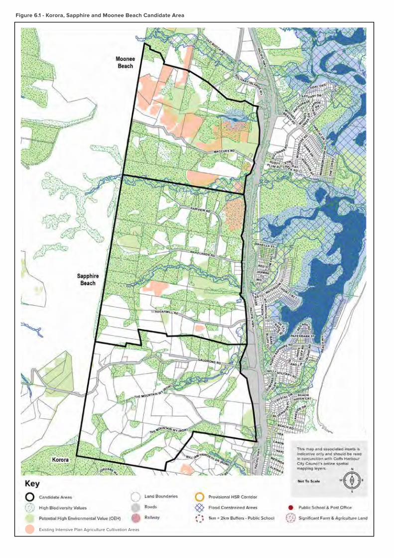
Figure 6.1 - Korora, Sapphire and Moonee Beach Candidate Area
Existing Intensive Plan Agriculture Cultivation Areas
16 Coffs Harbour Local Growth Management Strategy To 2040
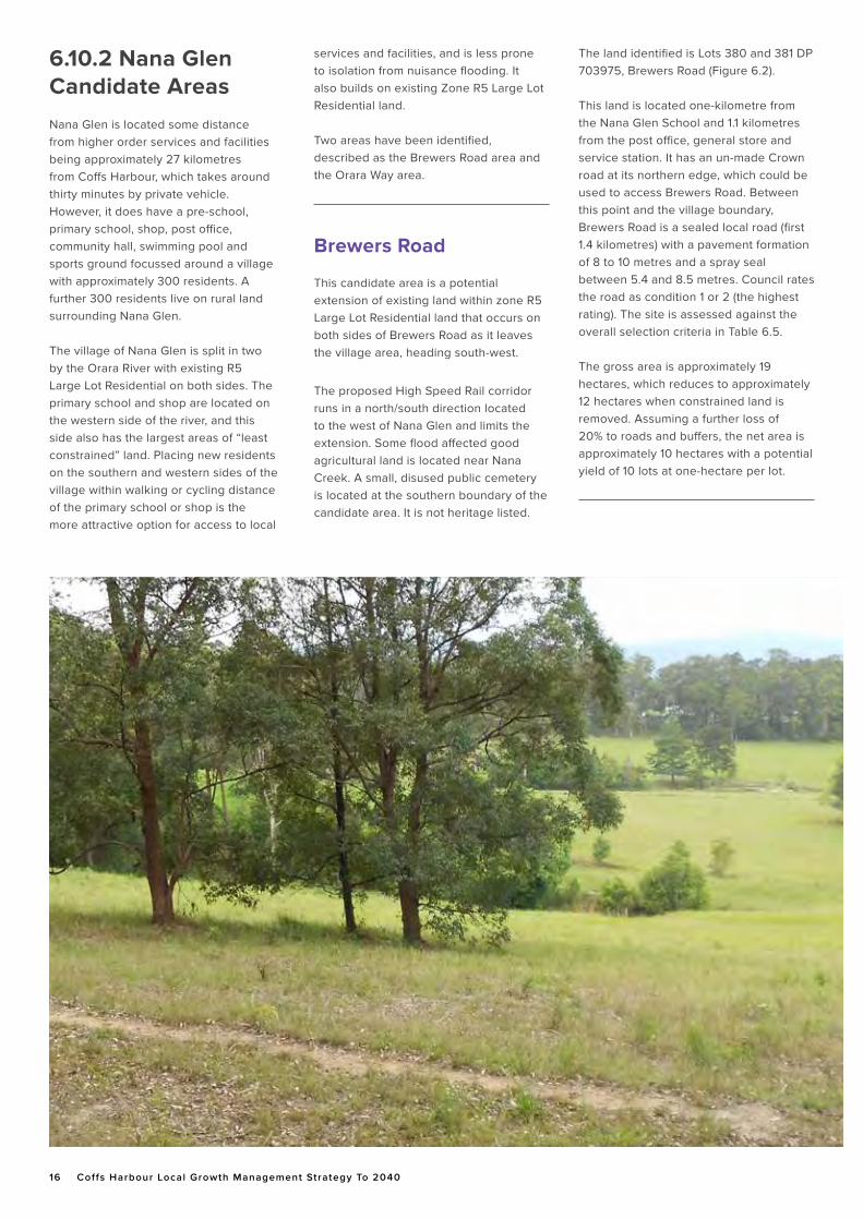
6.10.2 Nana Glen Candidate Areas
Nana Glen is located some distance from higher order services and facilities being approximately 27 kilometres from Coffs Harbour, which takes around thirty minutes by private vehicle. However, it does have a pre-school, primary school, shop, post office, community hall, swimming pool and sports ground focussed around a village with approximately 300 residents. A further 300 residents live on rural land surrounding Nana Glen.
The village of Nana Glen is split in two by the Orara River with existing R5 Large Lot Residential on both sides. The primary school and shop are located on the western side of the river, and this side also has the largest areas of “least constrained” land. Placing new residents on the southern and western sides of the village within walking or cycling distance of the primary school or shop is the more attractive option for access to local
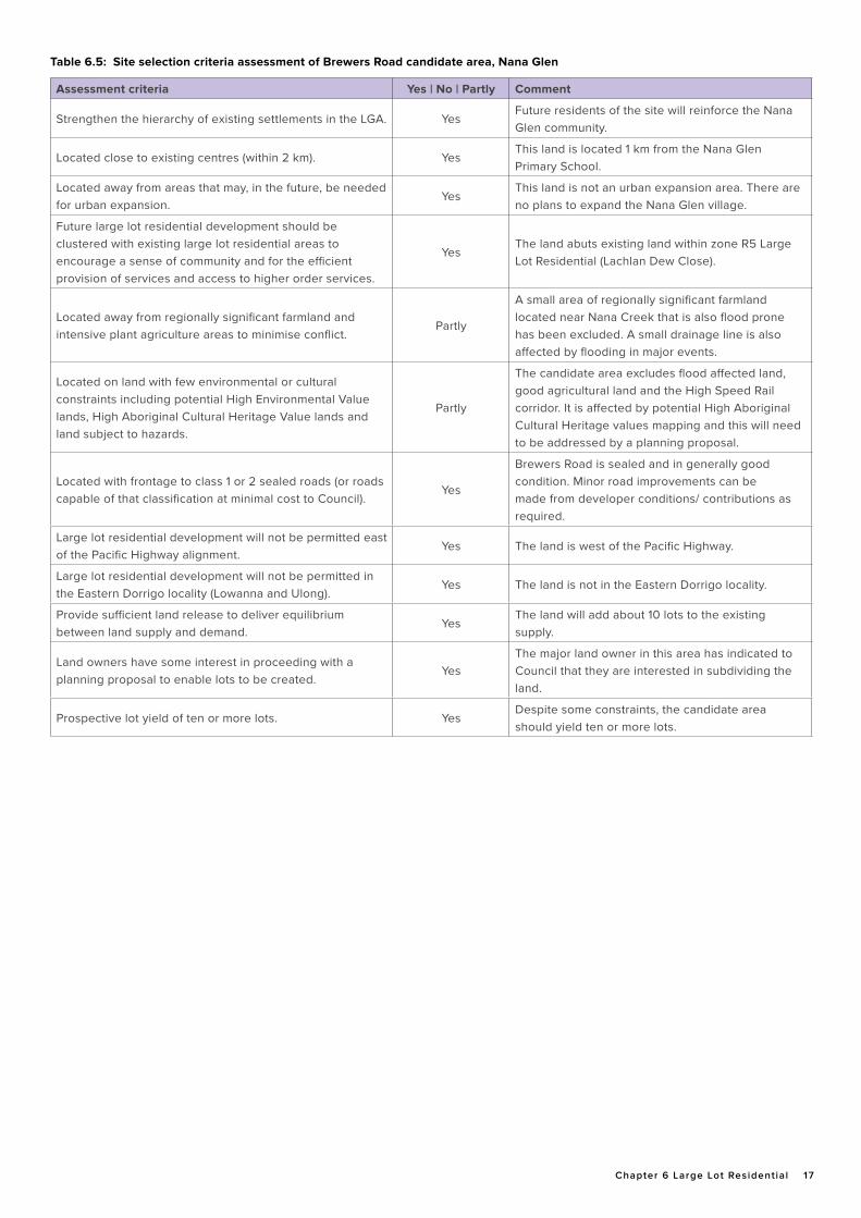
The land identified is Lots 380 and 381 DP 703975, Brewers Road (Figure 6.2).
This land is located one-kilometre from the Nana Glen School and 1.1 kilometres from the post office, general store and service station. It has an un-made Crown road at its northern edge, which could be used to access Brewers Road. Between this point and the village boundary, Brewers Road is a sealed local road (first 1.4 kilometres) with a pavement formation of 8 to 10 metres and a spray seal between 5.4 and 8.5 metres. Council rates the road as condition 1 or 2 (the highest rating). The site is assessed against the overall selection criteria in Table 6.5.
The gross area is approximately 19 hectares, which reduces to approximately 12 hectares when constrained land is removed. Assuming a further loss of 20% to roads and buffers, the net area is approximately 10 hectares with a potential yield of 10 lots at one-hectare per lot.
services and facilities, and is less prone to isolation from nuisance flooding. It also builds on existing Zone R5 Large Lot Residential land.
Two areas have been identified, described as the Brewers Road area and the Orara Way area.
Brewers Road
This candidate area is a potential extension of existing land within zone R5 Large Lot Residential land that occurs on both sides of Brewers Road as it leaves the village area, heading south-west.
The proposed High Speed Rail corridor runs in a north/south direction located to the west of Nana Glen and limits the extension. Some flood affected good agricultural land is located near Nana Creek. A small, disused public cemetery is located at the southern boundary of the candidate area. It is not heritage listed.
Chapter 6 Large Lot Residential 17
Assessment criteria Yes | No | Partly Comment
Strengthen the hierarchy of existing settlements in the LGA. YesFuture residents of the site will reinforce the Nana Glen community.
Located close to existing centres (within 2 km). YesThis land is located 1 km from the Nana Glen Primary School.
Located away from areas that may, in the future, be needed for urban expansion.
YesThis land is not an urban expansion area. There are no plans to expand the Nana Glen village.
Future large lot residential development should be clustered with existing large lot residential areas to encourage a sense of community and for the efficient provision of services and access to higher order services.
YesThe land abuts existing land within zone R5 Large Lot Residential (Lachlan Dew Close).
Located away from regionally significant farmland and intensive plant agriculture areas to minimise conflict.
Partly
A small area of regionally significant farmland located near Nana Creek that is also flood prone has been excluded. A small drainage line is also affected by flooding in major events.
Located on land with few environmental or cultural constraints including potential High Environmental Value lands, High Aboriginal Cultural Heritage Value lands and land subject to hazards.
Partly
The candidate area excludes flood affected land, good agricultural land and the High Speed Rail corridor. It is affected by potential High Aboriginal Cultural Heritage values mapping and this will need to be addressed by a planning proposal.
Located with frontage to class 1 or 2 sealed roads (or roads capable of that classification at minimal cost to Council).
Yes
Brewers Road is sealed and in generally good condition. Minor road improvements can be made from developer conditions/ contributions as required.
Large lot residential development will not be permitted east of the Pacific Highway alignment.
Yes The land is west of the Pacific Highway.
Large lot residential development will not be permitted in the Eastern Dorrigo locality (Lowanna and Ulong).
Yes The land is not in the Eastern Dorrigo locality.
Provide sufficient land release to deliver equilibrium between land supply and demand.
YesThe land will add about 10 lots to the existing supply.
Land owners have some interest in proceeding with a planning proposal to enable lots to be created.
YesThe major land owner in this area has indicated to Council that they are interested in subdividing the land.
Prospective lot yield of ten or more lots. YesDespite some constraints, the candidate area should yield ten or more lots.
Table 6.5: Site selection criteria assessment of Brewers Road candidate area, Nana Glen
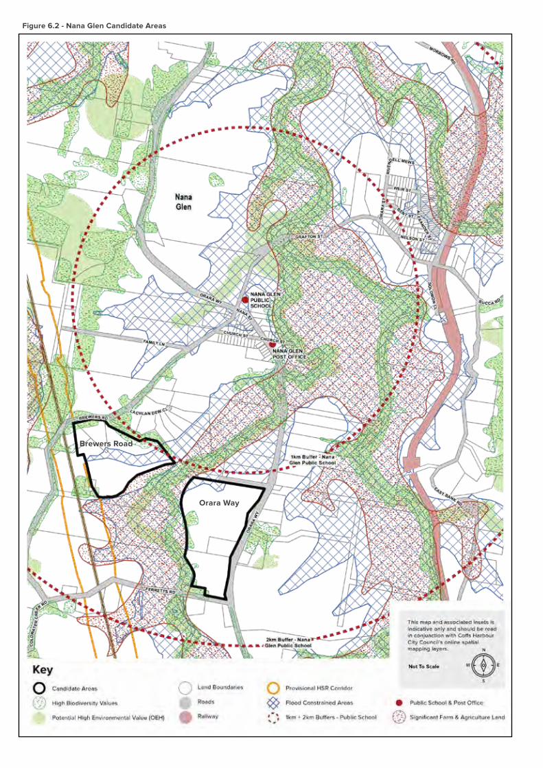
Figure 6.2 - Nana Glen Candidate Areas
Orara Way
Brewers Road
Chapter 6 Large Lot Residential 19
Orara Way
This candidate area is a potential new area of R5 Large Lot Residential along Orara Way at the southern entry to Nana
Glen. It would share a boundary to the west with the proposed Brewers Road extension area.
The land comprises three lots located between a partly made Crown road at the northern edge, where the Nana Glen Rural Fire Service shed is located, and Ferretts Road at the southern edge. The western boundary is Nana Creek and the eastern boundary is Orara Way.
Some flood affected good agricultural land is located near Nana Creek. A 132 kV overhead powerline traverses the site (roughly north/south). Part of the land is identified as potential High
Aboriginal Cultural Heritage Value and this may further constrain yields. The land identified is Lot 96 DP 134712 (Orara Way), Lot 841 DP 626741 (Ferretts Road) and Lot 7003 DP 93112 (Orara Way) (Figure 6.2). Lot 7003 is Council land (approximately 1.5 hectares) that is zoned RE1 Public Recreation but is currently not being used actively for recreation purposes.
The candidate area is located 1.2 kilometres from the Nana Glen School (at its closest point) and one-kilometre from the post office, general store and service station. It has 680 metres frontage to Orara Way and both the 70 kilometres per hour and 50 kilometres per hour speed zones are located along this frontage. Orara Way, along the candidate area frontage to the village boundary, is a sealed minor arterial road with a pavement formation of 8.4 metres and a spray seal of 6 metres. Council
rates the road as condition 4 (the second lowest rating). It is important that any future development of this site gain access from either Ferretts Road or the unnamed RFS shed access as no private driveway access along Orara Way will be acceptable. Intersection design for access points will need to meet appropriate design standards for the level of traffic anticipated. The cost of intersection upgrades needs to be considered as part of any future planning proposal.
The site is assessed against the overall selection criteria in Table 6.6.
The gross area is approximately 23 hectares, which reduces to approximately 16 hectares when constrained land is removed. Assuming a further loss of 20% to roads and buffers, the net area is approximately 13 hectares with a potential yield of 13 lots at one-hectare per lot.
Assessment criteria Yes | No | Partly Comment
Strengthen the hierarchy of existing settlements in the LGA. YesFuture residents of the site will reinforce the Nana Glen community.
Located close to existing centres (within 2 km). YesThis land is located 1.2 km from the Nana Glen Primary School.
Located away from areas that may, in the future, be needed for urban expansion.
YesThis land is not an urban expansion area. There are no plans to expand the Nana Glen village.
Future large lot residential development should be clustered with existing large lot residential areas to encourage a sense of community and for the efficient provision of services and access to higher order services.
NoIt abuts the proposed extension to the Brewers Road candidate area that is yet to be zoned.
Located away from regionally significant farmland and intensive plant agriculture areas to minimise conflict.
PartlyA small area of regionally significant farmland located near Nana Creek that is also flood prone has been excluded.
Located on land with few environmental or cultural constraints including potential High Environmental Value lands, High Aboriginal Cultural Heritage Value lands and land subject to hazards.
Partly
The candidate area excludes flood affected land and good agricultural land. It is affected by potential High Aboriginal Cultural Heritage values mapping and this will need to be addressed by a planning proposal.
Located with frontage to class 1 or 2 sealed roads (or roads capable of that classification at minimal cost to Council).
No
Orara Way is a minor arterial road and capable of dealing with additional traffic but it is currently not classified as a class 1 or 2 road. It is capable of being brought up to that standard. Intersection standards will need to be addressed by a planning proposal.
Large lot residential development will not be permitted east of the Pacific Highway alignment.
Yes The land is west of the Pacific Highway.
Large lot residential development will not be permitted in the Eastern Dorrigo locality (Lowanna and Ulong).
Yes The land is not in the Eastern Dorrigo locality.
Provide sufficient land release to deliver equilibrium between land supply and demand.
YesThe land will add about 13 lots to the existing supply.
Land owners have some interest in proceeding with a planning proposal to enable lots to be created.
YesThe major land owner in this area has indicated to Council that they are interested in subdividing the land.
Prospective lot yield of ten or more lots. YesDespite some constraints, the candidate area should yield ten or more lots.
Table 6.6: Site selection criteria assessment of Orara Way candidate area, Nana Glen
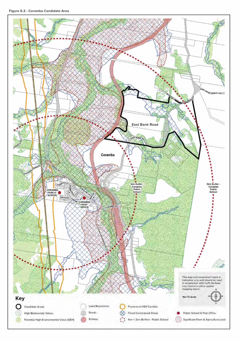
Figure 6.3 - Coramba Candidate Area
East Bank Road

Chapter 6 Large Lot Residential 21
6.10.3 Coramba Candidate Area
Coramba is located some distance from
higher order services and facilities being
approximately 15 kilometres from Coffs
Harbour, which takes around 15 minutes
by private vehicle. However, it does
have a pre-school and long day care
centre, primary school, shops, post office,
hotel, police station, community hall and
sports ground focussed around a village
with approximately 400 residents. A
further 400 residents live on rural land
surrounding Coramba.
The village of Coramba is split in two by
the Orara River and the North Coast Rail
Line with existing R5 Large Lot Residential
on both sides. The primary school and
shops, etc, are located on the western
side of the river and rail line. The smaller
eastern village area has a direct link via a
footbridge across the river. Although there
are areas of “least constrained” land on
both sides, the High Speed Rail corridor
traverses most of the potential land on
the western side, and the balance is flood
prone. Land to the south of the village
is constrained by the floodplain, rail line
and vegetated steep land, resulting in
small pockets with individual frontage to
Coramba Road. Placing new residents
on the northern and eastern sides of the
village within walking or cycling distance
of the primary school and shops is the
preferred option.
East Bank Road
This candidate area is a potential extension of land within zone R5 Large Lot Residential that occurs on both sides of East Bank Road as it leaves the eastern village area, heading north.
The land identified is part Lots 54, 55 and 56 DP 752834 (East Bank Road) and Lots 1 and 2 DP 1093448 (East Bank Road) (Figure 6.4). It is limited on one side by the North Coast Rail Line. The candidate area is located 1.5 kilometres from the Nana Glen School (at its closest point) via the footpath river crossing and 2 kilometres from the school via East Bank Road and Orara Way. It is 1.1 kilometres from the post office and shops via the footpath river crossing and 1.6 kilometres via East Bank Road and Orara Way. It has 1.2 kilometres combined frontage to East Bank Road with some of the candidate area located on either side. The Coramba Historic Cemetery is also located along this frontage.
East Bank Road, along the candidate area frontage to the village boundary, is a sealed rural collector road with a pavement formation between 7.8 and 10.2 metres and a spray seal between 5.4 and 6.2 metres. It is speed limited with the 50 kilometres per hour zone starting approximately 200 metres out from the eastern village area. Council rates the road as condition 1 or 2. It is important that any future development of this site gain access from a limited number of points as no private driveway access along East Bank Road will be acceptable. Intersection design for access points will need to meet appropriate design standards for the level of traffic anticipated. The cost of intersection establishment needs to be considered as part of any future planning proposal.
The site is assessed against the overall selection criteria in Table 6.7.
The gross area is approximately 54 hectares, which reduces to approximately 44 hectares when constrained land is removed. Assuming a further loss of 20% to roads and buffers, the net area is approximately 35 hectares with a potential yield of 35 lots at one-hectare per lot.
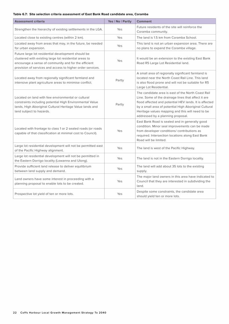
22 Coffs Harbour Local Growth Management Strategy To 2040
Assessment criteria Yes | No | Partly Comment
Strengthen the hierarchy of existing settlements in the LGA. YesFuture residents of the site will reinforce the Coramba community.
Located close to existing centres (within 2 km). Yes The land is 1.5 km from Coramba School.
Located away from areas that may, in the future, be needed for urban expansion.
YesThis land is not an urban expansion area. There are no plans to expand the Coramba village.
Future large lot residential development should be clustered with existing large lot residential areas to encourage a sense of community and for the efficient provision of services and access to higher order services.
YesIt would be an extension to the existing East Bank Road R5 Large Lot Residential land.
Located away from regionally significant farmland and intensive plant agriculture areas to minimise conflict.
Partly
A small area of regionally significant farmland is located near the North Coast Rail Line. This land is also flood prone and will not be suitable for R5 Large Lot Residential.
Located on land with few environmental or cultural constraints including potential High Environmental Value lands, High Aboriginal Cultural Heritage Value lands and land subject to hazards.
Partly
The candidate area is east of the North Coast Rail Line. Some of the drainage lines that affect it are flood affected and potential HEV lands. It is affected by a small area of potential High Aboriginal Cultural Heritage values mapping and this will need to be addressed by a planning proposal.
Located with frontage to class 1 or 2 sealed roads (or roads capable of that classification at minimal cost to Council).
Yes
East Bank Road is sealed and in generally good condition. Minor seal improvements can be made from developer conditions/ contributions as required. Intersection locations along East Bank Road will be limited.
Large lot residential development will not be permitted east of the Pacific Highway alignment.
Yes The land is west of the Pacific Highway.
Large lot residential development will not be permitted in the Eastern Dorrigo locality (Lowanna and Ulong).
Yes The land is not in the Eastern Dorrigo locality.
Provide sufficient land release to deliver equilibrium between land supply and demand.
YesThe land will add about 35 lots to the existing supply.
Land owners have some interest in proceeding with a planning proposal to enable lots to be created.
YesThe major land owners in this area have indicated to Council that they are interested in subdividing the land.
Prospective lot yield of ten or more lots. YesDespite some constraints, the candidate area should yield ten or more lots.
Table 6.7: Site selection criteria assessment of East Bank Road candidate area, Coramba
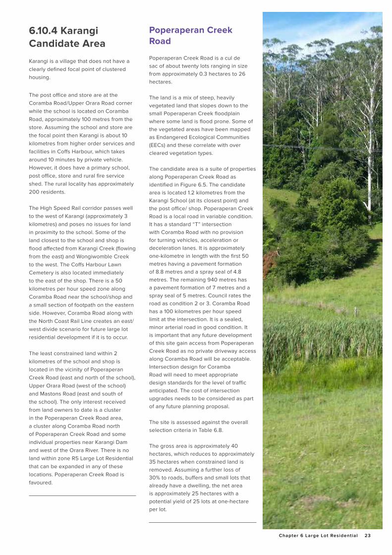
Chapter 6 Large Lot Residential 23
6.10.4 Karangi Candidate Area
Karangi is a village that does not have a clearly defined focal point of clustered housing.
The post office and store are at the Coramba Road/Upper Orara Road corner while the school is located on Coramba Road, approximately 100 metres from the store. Assuming the school and store are the focal point then Karangi is about 10 kilometres from higher order services and facilities in Coffs Harbour, which takes around 10 minutes by private vehicle. However, it does have a primary school, post office, store and rural fire service shed. The rural locality has approximately 200 residents.
The High Speed Rail corridor passes well to the west of Karangi (approximately 3 kilometres) and poses no issues for land in proximity to the school. Some of the land closest to the school and shop is flood affected from Karangi Creek (flowing from the east) and Wongiwomble Creek to the west. The Coffs Harbour Lawn Cemetery is also located immediately to the east of the shop. There is a 50 kilometres per hour speed zone along Coramba Road near the school/shop and a small section of footpath on the eastern side. However, Coramba Road along with the North Coast Rail Line creates an east/west divide scenario for future large lot residential development if it is to occur.
The least constrained land within 2 kilometres of the school and shop is located in the vicinity of Poperaperan Creek Road (east and north of the school), Upper Orara Road (west of the school) and Mastons Road (east and south of the school). The only interest received from land owners to date is a cluster in the Poperaperan Creek Road area, a cluster along Coramba Road north of Poperaperan Creek Road and some individual properties near Karangi Dam and west of the Orara River. There is no land within zone R5 Large Lot Residential that can be expanded in any of these locations. Poperaperan Creek Road is favoured.
Poperaperan Creek Road
Poperaperan Creek Road is a cul de sac of about twenty lots ranging in size from approximately 0.3 hectares to 26 hectares.
The land is a mix of steep, heavily vegetated land that slopes down to the small Poperaperan Creek floodplain where some land is flood prone. Some of the vegetated areas have been mapped as Endangered Ecological Communities (EECs) and these correlate with over cleared vegetation types.
The candidate area is a suite of properties along Poperaperan Creek Road as identified in Figure 6.5. The candidate area is located 1.2 kilometres from the Karangi School (at its closest point) and the post office/ shop. Poperaperan Creek Road is a local road in variable condition. It has a standard “T” intersection with Coramba Road with no provision for turning vehicles, acceleration or deceleration lanes. It is approximately one-kilometre in length with the first 50 metres having a pavement formation of 8.8 metres and a spray seal of 4.8 metres. The remaining 940 metres has a pavement formation of 7 metres and a spray seal of 5 metres. Council rates the road as condition 2 or 3. Coramba Road has a 100 kilometres per hour speed limit at the intersection. It is a sealed, minor arterial road in good condition. It is important that any future development of this site gain access from Poperaperan Creek Road as no private driveway access along Coramba Road will be acceptable. Intersection design for Coramba Road will need to meet appropriate design standards for the level of traffic anticipated. The cost of intersection upgrades needs to be considered as part of any future planning proposal.
The site is assessed against the overall selection criteria in Table 6.8.
The gross area is approximately 40 hectares, which reduces to approximately 35 hectares when constrained land is removed. Assuming a further loss of 30% to roads, buffers and small lots that already have a dwelling, the net area is approximately 25 hectares with a potential yield of 25 lots at one-hectare per lot.

24 Coffs Harbour Local Growth Management Strategy To 2040
Figure 6.4 - Karangi Candidate Area
Poperaperan Creek Road
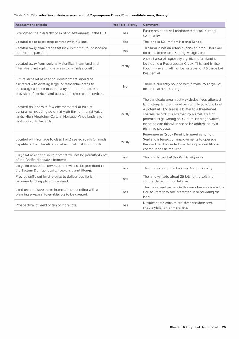
Chapter 6 Large Lot Residential 25
Assessment criteria Yes | No | Partly Comment
Strengthen the hierarchy of existing settlements in the LGA. YesFuture residents will reinforce the small Karangi community.
Located close to existing centres (within 2 km). Yes The land is 1.2 km from Karangi School.
Located away from areas that may, in the future, be needed for urban expansion.
YesThis land is not an urban expansion area. There are no plans to create a Karangi village zone.
Located away from regionally significant farmland and intensive plant agriculture areas to minimise conflict.
Partly
A small area of regionally significant farmland is located near Poperaperan Creek. This land is also flood prone and will not be suitable for R5 Large Lot Residential.
Future large lot residential development should be clustered with existing large lot residential areas to encourage a sense of community and for the efficient provision of services and access to higher order services.
NoThere is currently no land within zone R5 Large Lot Residential near Karangi.
Located on land with few environmental or cultural constraints including potential High Environmental Value lands, High Aboriginal Cultural Heritage Value lands and land subject to hazards.
Partly
The candidate area mostly excludes flood affected land, steep land and environmentally sensitive land. A potential HEV area is a buffer to a threatened species record. It is affected by a small area of potential High Aboriginal Cultural Heritage values mapping and this will need to be addressed by a planning proposal.
Located with frontage to class 1 or 2 sealed roads (or roads capable of that classification at minimal cost to Council).
Partly
Poperaperan Creek Road is in good condition. Seal and intersection improvements to upgrade the road can be made from developer conditions/ contributions as required.
Large lot residential development will not be permitted east of the Pacific Highway alignment.
Yes The land is west of the Pacific Highway.
Large lot residential development will not be permitted in the Eastern Dorrigo locality (Lowanna and Ulong).
Yes The land is not in the Eastern Dorrigo locality.
Provide sufficient land release to deliver equilibrium between land supply and demand.
YesThe land will add about 25 lots to the existing supply, depending on lot size.
Land owners have some interest in proceeding with a planning proposal to enable lots to be created.
YesThe major land owners in this area have indicated to Council that they are interested in subdividing the land.
Prospective lot yield of ten or more lots. YesDespite some constraints, the candidate area should yield ten or more lots.
Table 6.8: Site selection criteria assessment of Poperaperan Creek Road candidate area, Karangi
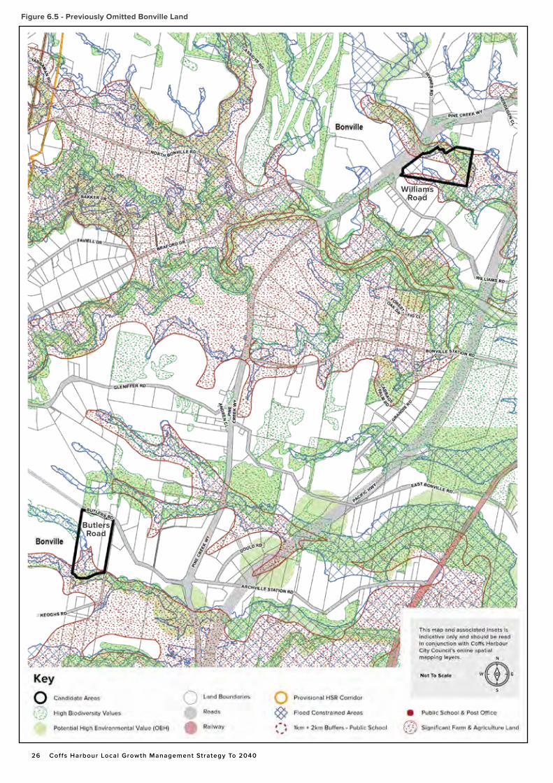
26 Coffs Harbour Local Growth Management Strategy To 2040
Figure 6.5 - Previously Omitted Bonville Land
Butlers Road
Williams Road
Chapter 6 Large Lot Residential 27
6.10.5 Previously Omitted Bonville Land
Council at its Ordinary Meeting of 8 December 2016 resolved to adopt a planning proposal to rezone suitable land within the Bonville Large Lot Residential Investigation Area for large lot residential purposes.
Three land parcels within this planning proposal were included post exhibition to address submissions made during the formal exhibition period for the Planning Proposal. These lands are located as shown on Figure 6.5
The subject land parcels formally known as Lot 4 DP 41228 (81 Butlers Road), Lot
5 DP 41228 (75-77 Butlers Road), and Lot 222 DP 852558 (1 – 1A Williams Road) were not identified within the Bonville Large Lot Residential Candidate area of Council’s endorsed Rural Residential Strategy 2009. Despite this, Council at its Meeting of 8 December 2016 endorsed the inclusion of this land in the Planning Proposal.
When seeking endorsement from the former NSW Planning and Environment for the planning proposal, Council was advised by the Department that it was not able to endorse the inclusion of these land parcels as they had not been subject to community consultation in accordance with the Gateway Determination. It was suggested by the Department at this time, that consideration of these land parcels for large lot residential purposes could
be addressed by individual proponent led planning proposals.
On the basis of this advice, an action is provided within Section 6.12.1 of this Chapter to enable proponent initiated planning proposals to be submitted to Council seeking the rezoning of suitable land within the subject lots. Such planning proposals are to be suitably justified based on site specific land capability assessments relative to the characteristics of the land, including detailed consideration of regionally significant farmland and flood hazard.
The likely resulting lot yield from these sites is minor due to the characteristics of the land and thus inclusion of these lots is unlikely to impact on the demand and supply calculations within this Chapter.
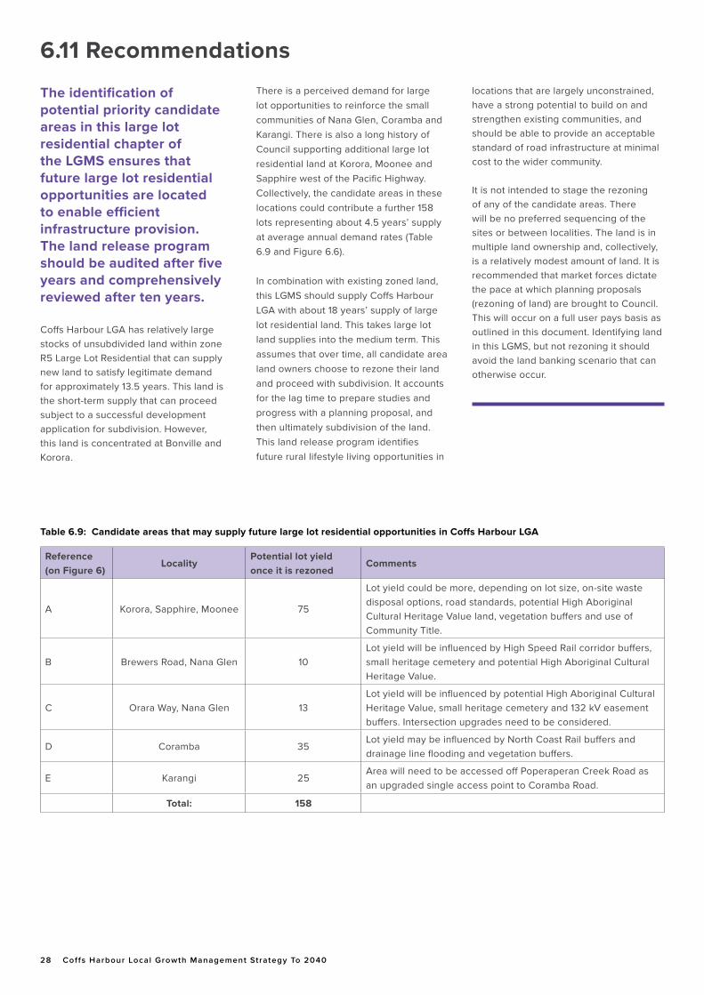
28 Coffs Harbour Local Growth Management Strategy To 2040
The identification of potential priority candidate areas in this large lot residential chapter of the LGMS ensures that future large lot residential opportunities are located to enable efficient infrastructure provision. The land release program should be audited after five years and comprehensively reviewed after ten years.
Coffs Harbour LGA has relatively large stocks of unsubdivided land within zone R5 Large Lot Residential that can supply new land to satisfy legitimate demand for approximately 13.5 years. This land is the short-term supply that can proceed subject to a successful development application for subdivision. However, this land is concentrated at Bonville and Korora.
There is a perceived demand for large lot opportunities to reinforce the small communities of Nana Glen, Coramba and Karangi. There is also a long history of Council supporting additional large lot residential land at Korora, Moonee and Sapphire west of the Pacific Highway. Collectively, the candidate areas in these locations could contribute a further 158 lots representing about 4.5 years’ supply at average annual demand rates (Table 6.9 and Figure 6.6).
In combination with existing zoned land, this LGMS should supply Coffs Harbour LGA with about 18 years’ supply of large lot residential land. This takes large lot land supplies into the medium term. This assumes that over time, all candidate area land owners choose to rezone their land and proceed with subdivision. It accounts for the lag time to prepare studies and progress with a planning proposal, and then ultimately subdivision of the land. This land release program identifies future rural lifestyle living opportunities in
locations that are largely unconstrained, have a strong potential to build on and strengthen existing communities, and should be able to provide an acceptable standard of road infrastructure at minimal cost to the wider community.
It is not intended to stage the rezoning of any of the candidate areas. There will be no preferred sequencing of the sites or between localities. The land is in multiple land ownership and, collectively, is a relatively modest amount of land. It is recommended that market forces dictate the pace at which planning proposals (rezoning of land) are brought to Council. This will occur on a full user pays basis as outlined in this document. Identifying land in this LGMS, but not rezoning it should avoid the land banking scenario that can otherwise occur.
Reference(on Figure 6)
LocalityPotential lot yield once it is rezoned
Comments
A Korora, Sapphire, Moonee 75
Lot yield could be more, depending on lot size, on-site waste disposal options, road standards, potential High Aboriginal Cultural Heritage Value land, vegetation buffers and use of Community Title.
B Brewers Road, Nana Glen 10Lot yield will be influenced by High Speed Rail corridor buffers, small heritage cemetery and potential High Aboriginal Cultural Heritage Value.
C Orara Way, Nana Glen 13Lot yield will be influenced by potential High Aboriginal Cultural Heritage Value, small heritage cemetery and 132 kV easement buffers. Intersection upgrades need to be considered.
D Coramba 35Lot yield may be influenced by North Coast Rail buffers and drainage line flooding and vegetation buffers.
E Karangi 25Area will need to be accessed off Poperaperan Creek Road as an upgraded single access point to Coramba Road.
Total: 158
Table 6.9: Candidate areas that may supply future large lot residential opportunities in Coffs Harbour LGA
6.11 Recommendations
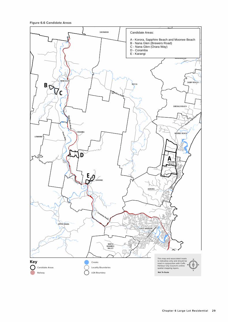
Chapter 6 Large Lot Residential 29
WOOLGOOLGA
NANA GLENBUCCA
LOWANNA
SANDY BEACH
CORAMBA
KARANGI
SAPPHIREBEACH
UPPER ORARA
KORORA
COFFS HARBOUR
NORTHBOAMBEE
VALLEY
UPPER CORINDISHERWOOD
MOONEE BEACH
EMERALD BEACH
Candidate Areas:
A - Korora, Sapphire Beach and Moonee BeachB - Nana Glen (Brewers Road)C - Nana Glen (Orara Way)D - CorambaE - Karangi
A
B
D
E
C
Pacifi
c Hig
hway
Pacific Highway
Bucca Road
Orara W
ay
Coramba Road
East Bank R
oad
Candidate Areas
Railway
Key Creeks
Locality Boundaries
LGA Boundary
N
S
EW
Not To Scale
This map and associated insets is indicative only and should be read in conjunction with Co�s Harbour City Council’s online spatial mapping layers.
Figure 6.6 Candidate Areas
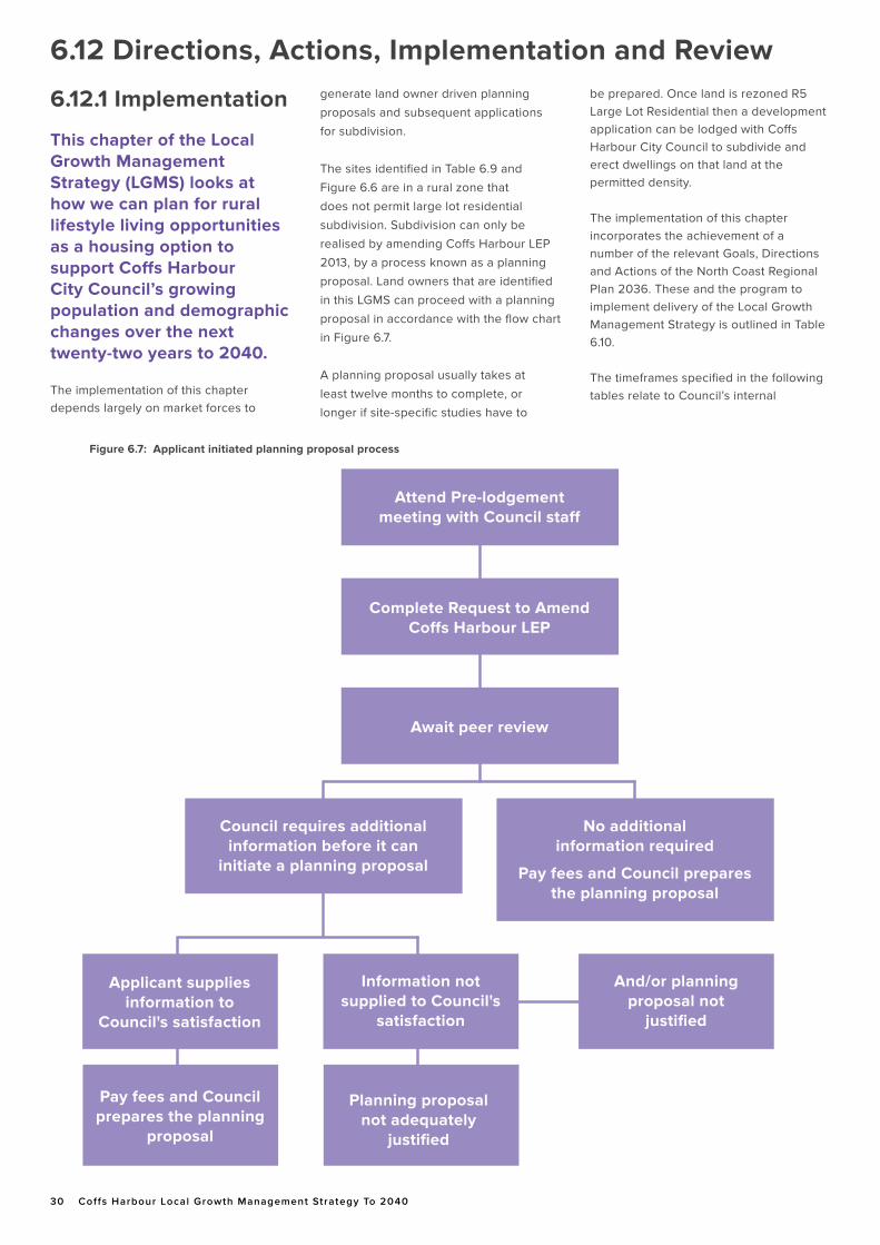
30 Coffs Harbour Local Growth Management Strategy To 2040
6.12.1 Implementation
This chapter of the Local Growth Management Strategy (LGMS) looks at how we can plan for rural lifestyle living opportunities as a housing option to support Coffs Harbour City Council’s growing population and demographic changes over the next twenty-two years to 2040.
The implementation of this chapter depends largely on market forces to
generate land owner driven planning
proposals and subsequent applications
for subdivision.
The sites identified in Table 6.9 and
Figure 6.6 are in a rural zone that
does not permit large lot residential
subdivision. Subdivision can only be
realised by amending Coffs Harbour LEP
2013, by a process known as a planning
proposal. Land owners that are identified
in this LGMS can proceed with a planning
proposal in accordance with the flow chart
in Figure 6.7.
A planning proposal usually takes at
least twelve months to complete, or
longer if site-specific studies have to
be prepared. Once land is rezoned R5 Large Lot Residential then a development application can be lodged with Coffs Harbour City Council to subdivide and erect dwellings on that land at the permitted density. The implementation of this chapter incorporates the achievement of a number of the relevant Goals, Directions and Actions of the North Coast Regional Plan 2036. These and the program to implement delivery of the Local Growth Management Strategy is outlined in Table 6.10.
The timeframes specified in the following tables relate to Council’s internal
Figure 6.7: Applicant initiated planning proposal process
Complete Request to AmendCoffs Harbour LEP
Attend Pre-lodgementmeeting with Council staff
Await peer review
Applicant supplies information to
Council's satisfaction
Information not supplied to Council's
satisfaction
And/or planning proposal not
justified
Council requires additional information before it can
initiate a planning proposal
Pay fees and Council prepares the planning
proposal
Planning proposalnot adequately
justified
No additional information required
Pay fees and Council prepares the planning proposal
6.12 Directions, Actions, Implementation and Review
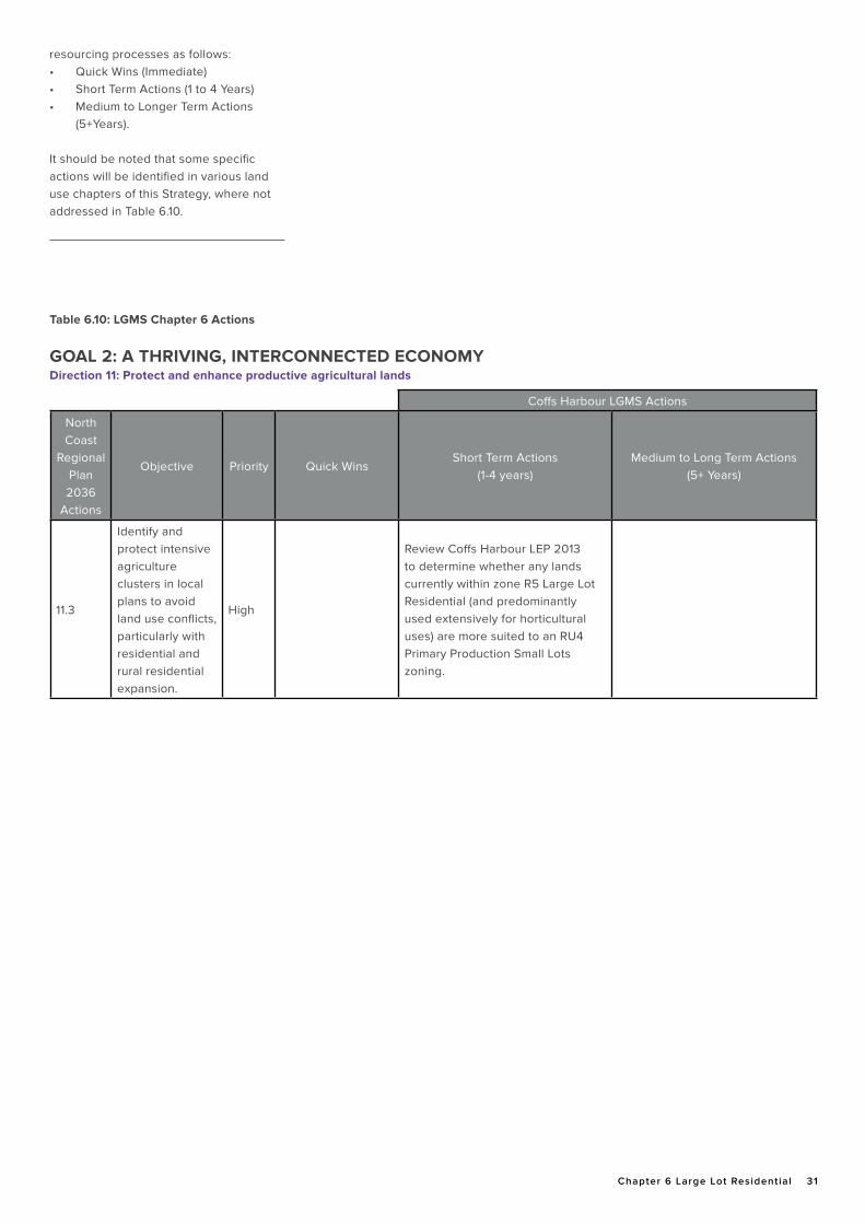
Chapter 6 Large Lot Residential 31
resourcing processes as follows:• Quick Wins (Immediate)• Short Term Actions (1 to 4 Years)• Medium to Longer Term Actions
(5+Years).
It should be noted that some specific actions will be identified in various land use chapters of this Strategy, where not addressed in Table 6.10.
Coffs Harbour LGMS Actions
North Coast
Regional Plan 2036
Actions
Objective Priority Quick WinsShort Term Actions
(1-4 years)Medium to Long Term Actions
(5+ Years)
11.3
Identify and protect intensive agriculture clusters in local plans to avoid land use conflicts, particularly with residential and rural residential expansion.
High
Review Coffs Harbour LEP 2013 to determine whether any lands currently within zone R5 Large Lot Residential (and predominantly used extensively for horticultural uses) are more suited to an RU4 Primary Production Small Lots zoning.
Table 6.10: LGMS Chapter 6 Actions
GOAL 2: A THRIVING, INTERCONNECTED ECONOMYDirection 11: Protect and enhance productive agricultural lands
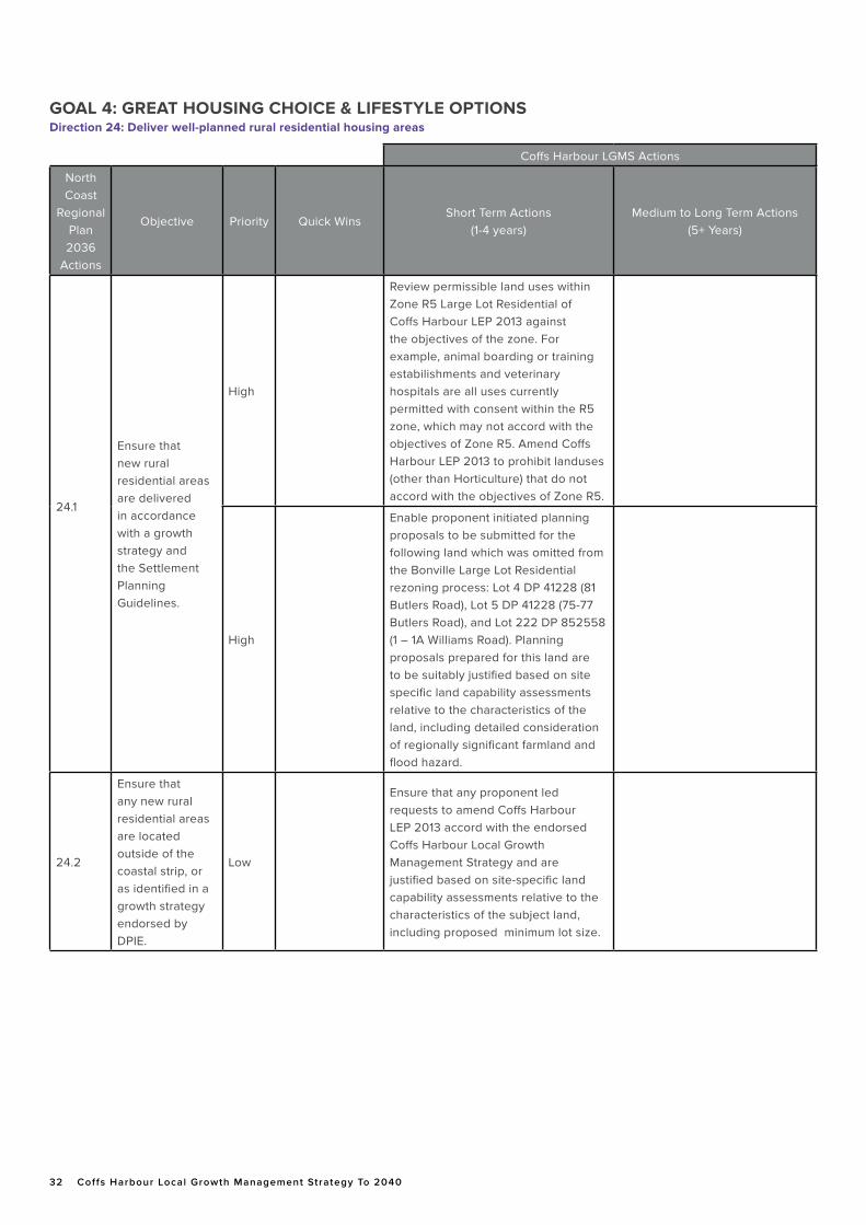
32 Coffs Harbour Local Growth Management Strategy To 2040 DRAFT Chapter 6 Large Lot Residential 32
Coffs Harbour LGMS Actions
North Coast
Regional Plan 2036
Actions
Objective Priority Quick WinsShort Term Actions
(1-4 years)Medium to Long Term Actions
(5+ Years)
24.1
Ensure that new rural residential areas are delivered in accordance with a growth strategy and the Settlement Planning Guidelines.
High
Review permissible land uses within Zone R5 Large Lot Residential of Coffs Harbour LEP 2013 against the objectives of the zone. For example, animal boarding or training estabilishments and veterinary hospitals are all uses currently permitted with consent within the R5 zone, which may not accord with the objectives of Zone R5. Amend Coffs Harbour LEP 2013 to prohibit landuses (other than Horticulture) that do not accord with the objectives of Zone R5.
High
Enable proponent initiated planning proposals to be submitted for the following land which was omitted from the Bonville Large Lot Residential rezoning process: Lot 4 DP 41228 (81 Butlers Road), Lot 5 DP 41228 (75-77 Butlers Road), and Lot 222 DP 852558 (1 – 1A Williams Road). Planning proposals prepared for this land are to be suitably justified based on site specific land capability assessments relative to the characteristics of the land, including detailed consideration of regionally significant farmland and flood hazard.
24.2
Ensure that any new rural residential areas are located outside of the coastal strip, or as identified in a growth strategy endorsed by DPIE.
Low
Ensure that any proponent led requests to amend Coffs Harbour LEP 2013 accord with the endorsed Coffs Harbour Local Growth Management Strategy and are justified based on site-specific land capability assessments relative to the characteristics of the subject land, including proposed minimum lot size.
GOAL 4: GREAT HOUSING CHOICE & LIFESTYLE OPTIONSDirection 24: Deliver well-planned rural residential housing areas
Chapter 6 Large Lot Residential 33
6.12.2 Monitoring and Review
There will be ongoing monitoring of the LGMS with the aim of making further improvements as additional information becomes available. This includes reporting every two years on approvals for lots and dwellings in zone R5 Large Lot Residential.
The large lot residential chapter of the LGMS should be reviewed within ten years to assess supply and demand assumptions and the way owners of candidate areas have responded to inclusion in the LGMS. It should not be assumed that a future LGMS will contain a large lot residential chapter. The Department of Planning, Industry and Environment advises North Coast Councils that it should not be considered an essential component of the LGA’s future housing needs; the majority of which should be provided in urban areas (DPIE, 2018).
6.13 Resourcing Policy ChangesResourcing implications need to be considered with the adoption by Council of Chapter 6.
This Strategy identifies that local planning controls should be amended to remove landuses that do not accord with the objectives of Zone R5 Large Lot Residential, excluding Horticulture; and to review whether any existing horticultural clusters would be more suited to Zone RU4 Primary Production Small Lots.
The potential land use conflicts associated with land zoned R5 Large Lot Residential will continue to have some resourcing implications for Council to achieve the desired outcomes of this Strategy. This is because Council will need to undertake some compliance work to enforce these land use conflict issues. However, the benefits to residents living in these areas will outweigh the costs of this additional compliance resource.
It is currently anticipated that some additional part-time development assessment and compliance positions would be required to resource work generated by these policy changes.


