Colchester Local Highway Panel Meeting Agenda Date: Tuesday 10 th January 2017 Time: 14:00 hrs Venue: County Hall, Chelmsford, Committee Room 3 Chairman: CC Member Anne Brown Panel Members: Colchester Cllr Lyn Barton (Deputy), CC Member Kevin Bentley, CC Member Julie Young, CC Member Sue Lissimore, CC Member Anne Turrell, Cllr Brian Jarvis, Colchester Cllr Dennis Willetts, Parish Representative Cllr John Gili-Ross. Other Attendees: EH Sonia Church - Highways Liaison Manager EH Joe Hazelton - Highways Liaison Officer Secretariat: EH Jasmine Wiles – Highways Liaison Apprentice Page Item Lead Papers 1 Welcome & Introductions Chairman Verbal 2 Apologies of Absence Declarations of Interest Chairman Verbal 3 Minutes of meeting held on 10 th October 2016 to be agreed as a correct record Chairman Report 1 4 Approved Works Programme 2016/17 Joe Hazelton Report 2 5 Potential Schemes for consideration of Panel in 2016/17 Safer Roads Traffic Management Walking Passenger Transport Cycling Public Rights of Way Joe Hazelton Report 3 Appendix S106 Update Rangers Report Completed Designs Joe Hazelton Report 4 AOB Joe Hazelton Verbal Date of next meeting: To be confirmed All Verbal * Any member of public wishing to attend the Colchester LHP meeting must arrange a formal invitation from the LHP Chairman. Any public questions should be submitted no later than Friday 23 rd December 2016 to [email protected]
Transcript
Colchester Local Highway Panel Meeting Agenda
Date: Tuesday 10th January 2017
Time: 14:00 hrs
Venue: County Hall, Chelmsford, Committee Room 3
Chairman: CC Member Anne Brown
Panel Members: Colchester Cllr Lyn Barton (Deputy), CC Member Kevin Bentley, CC Member Julie Young, CC Member Sue Lissimore, CC Member Anne Turrell, Cllr Brian Jarvis, Colchester Cllr Dennis Willetts, Parish Representative Cllr John Gili-Ross.
Other Attendees: EH Sonia Church - Highways Liaison Manager
Present: County Councillor Anne Brown (Chairman), Colchester Cllr Lyn Barton (Vice), County Councillor Sue Lissimore, County Councillor Julie Young, Cllr Brian Jarvis, Cllr Anne Turrell and Cllr Dennis Willetts and Parish Cllr John Gili-Ross. Apologies: County Councillor Kevin Bentley.
Other Attendees: Sonia Church - SC (Highways Liaison Manager), Joe Hazelton - JH (Highways Liaison Officer), Jasmine Wiles (Highways Liaison Apprentice), Cllr Harris, Cllr Cope, Major Nick Berry and Ms Laurel Juniper
Item Action Action Owner
1. Welcome and Introductions Cllr Brown welcomed everyone to the meeting. All present introduced themselves.
2. Declarations of Interest/ Election of Chairman and Vice Chairman
3. Minutes of Meeting held on 10th October 2016 Cllr Brown led the panel through the minutes. Matters Arising Action- JH to forward link to Traffweb to Cllr Turrell All of the pervious actions from the last panel meeting have been addressed. Major schemes JH managed to get Alan Lindsey to the LHP meeting to talk about the major schemes around Colchester. Resurfacing the roads
JH
Report 1
1
Cllr Bentley asked SC if she has received a response from the Capital Maintenance Department. SC states that she has not received a suitable response and this has been escalated. Cllr Bentley gives an example of Church Road, Stanway where the kerb is level to the road. This leads to flooding, luckily the bricks are aerated in this location. SC emailed Cllr Bentley with a response to these questions from the previous meeting (kept above) and is awaiting a response. Cllr Young’s missing schemes Cllr Young mentioned that Vine Drive is still missing from the potential schemes list. Action- JH to add scheme to the PSL Passenger Transport JH explained that he brought more PT schemes to the previous panel meeting and are looking to have a more robust list by January. Questioned if the panel would like a member of Passenger Transport to attend the panel. A majority of the panel members were happy with the update that JH provided. Safer Roads LCOL152161- Mile End Road, Nayland Road, Defoe Crescent, Mill Road West and associated Cul-de-sacs, Colchester JH stated that there has been a change of name it is now Mill end. They are currently waiting to hear about possible S106 funding. Walking LCOL152017 - Western Bypass, Stanway SC told the panel that she is waiting for the analysis and suggested leaving on the minutes for discussing within the next panel meeting. AL indicated that there are currently two possible interests in the bridge. Cllr Young questioned how these decisions get determined. Cllr Brown asked if the bridge was owned by the LHP or County. SC mentioned that they would have to wait to hear back from the analysis. Cllr Young raised that Tesco with the Hythe could be another location for the bridge. Approved Work Programme
JH
2
LCOL152006 - Dedham, Stratford Road JH mentioned that a CMA has been started and is yet to speak to Cllr Johnson. LCOL001010 - Glen Avenue and A133 Cymbeline Way Colchester Cllr Jarvis mentioned that the scheme has slipped to Quarter 4. SC explained to the panel that the permitting team cannot book the road space due to the other works being carried out. Cllr Jarvis claimed that there has been no road works carried out down Glen Avenue and questioned how there could be possible conflict. SC explained that there are no works in the vicinity of Glen Avenue however the current works down Colne Bank Avenue and the Albert Roundabout would cause conflict with Glen Avenue. Action- JH to keep the panel up to date with this scheme LCOL152084 - The Strood, Mersea SC mentions that a press release will be done however currently when the scheme was implemented the company who installed made sure that most of the elements were salt water protected apart from the switch and a couple of pins. JH explained that he is in contact with the relevant member of staff and is awaiting a formal response. SC stated that the issue with the light being straight and not flashing making it seem navigational has been raised. Action- Cllr Jowers to come back with answers LCOL158002 - Footpath 8 Wivenhoe - Adjacent to Wivenhoe train station JH mentioned that he had met Cllr Young on site and discussed the scheme. Also raised that he has spoken to the manager of the PROW team who has mentioned that the ditch clearance works have been completed and everything has now been passed to Network Rail. LCOL162004 - Lower Road / St Ives Road, Stanway Cllr Bentley explains to JH that he has the incorrect location, that it should be Peldon not Stanway. Cllr Bentley also mentioned that the Parish Council have emailed him to talk about the location. JH states that he is just waiting for a Highway Boundary. Action - Cllr Bentley to tell parish council that they are waiting on a Highway Boundary. LCOL168001 - Braiswick Lane, Mile End FP41 JH mentioned that it is the back of FP41 which is why it is incorporated in the title. Stated that he can look into changing the name of this scheme in the future if it still causes confusion.
JH Cllr Jowers Cllr Bentley
3
Missing VAS in Wivenhoe Cllr Brown stated that they wanted this to go ahead. JH mentioned that the design is in process and it is just being finalised. Cllr Gili-Ross requested an update on VAS maintenance. SC confirmed that since the beginning of this financial year the VAS maintenance is being funded by the revenue budget, due to the street lighting budget being cut. Action- JH to provide the panel members with a list of VAS signs that have maintenance issues. Panel to return with any they believe are missing from the list. Cllr Lissimore questioned if anyone knew about the VAS signs that were implemented before the LHP budget, are the panel financing there maintenance. SC stated that when a VAS sign needs maintenance a speed survey is done to see if the sign still meets the criteria. Action- SC to circulate VAS practice note. Cllr Gilli-Ross questioned how much VAS sign costs. SC confirmed that if the pole is already in place then they cost around £3,500. If it is a new sign it would require a design and would cost around £8,000. SC suggested that when the panel members go to the parishes to see which VAS signs they believe need maintenance work to mention that the speeds are set at 34mph. Cllr Willetts exclaimed he was glad to know there was a practice note and suggested that if it is now within the revenue budget to consider VAS maintenance then the panel members should have a clearer understanding and should be aware of the criteria for VAS signs so they are aware of when one needs maintenance or removing. Cllr Brown asked JH to search and find out more information and to put on the agenda for next time. JH to find out more info on VAS maintenance and to provide information at the next panel. S106 Update JH explained that he has some S106 schemes within the panel report and they will be looked at when the panel reach the appendix. However there is not a lot of information on the schemes. Cllr Turrell mentioned that Colchester Borough Council have had basic information on S106 schemes. Cllr Barton to find out the necessary person to contact about S106 schemes within Colchester Borough Council.
JH SC JH Cllr Barton
4
AL stated that he may be able to help SC with this issue. Cllr Lissimore mentioned that schemes they say have been completed actually haven’t. Stated that there is no point involving the list if it is inaccurate. Action- JH to liaise with SC and AL to find a better update and if one is not available to not include within the panel reports for discussion. Rangers Cllr Brown explained that SC has done a lot of work on the Colchester Rangers since the previous panel meeting and has found out that the member of staff who does the rangers work is on long term sick leave. Cllr Brown stated that she has spoken to Cllr Bentley previous to the panel meeting and asked him to raise and see if Colchester could take over rangers. Action- Cllr Brown stated that Cllr Bentley would have until the next panel meeting to report about rangers. Cllr Gilli-Ross noticed a mistake within the previous minutes stating that the parishes are uninsured. Action- JH to correct the previous minutes. Cllr Gilli- Ross mentioned the scheme within West Bergholt the 20mph limit near the school and stated that it has been going on for ages and there was a sign made within a competition but nobody is going to say it is enforceable. SC explained that it would be a 20’s plenty it wouldn’t be a limit it would be a suggested speed around the schools location and stated that if they are to put it on their own land they do not have to go through Essex County Council and can just implement the sign.
JH Cllr Bentley JH
4. Major Projects The Local Growth Fund (LGF) packages are:
Colchester Park and Ride and Bus Priority Measures AL mentioned that the Colchester Park and ride has been completed and on the second day of it running officers were riding on the buses to make sure they were running accurately.
Colchester Integrated Transport Package (Town Centre Traffic and Access Strategy)
5
High Street - Removing the uncontrolled pedestrian crossing point located outside the George Hotel - Minor alterations to the existing bank of bus stops - Drainage and the relocation of bus stop flags and bus shelters - Improvements to footway surfaces Colchester Town Centre Passageways Improvements - New paving, lighting and accessibility improvements to Bank Passage, Pelham’s Lane and St Nicholas passage - Improved route signage
Middleborough Bus Stops - Minor carriageway and footway widening Northbound and Southbound - New bus kerbs and an additional Park and Ride bus shelter - Will be localised changes to existing loading restrictions Head Street - Full length raised bus stop kerbs - Further improvements to associated drainage, relocation of bus stop flags, bus service shelters and footway surfaces.
Colchester Local Sustainable Transport Programme Lexden Road Scheme Proposal - Improvements to the London Road/Straight Road junction - Improvements to the Norman Way junction with Lexden Road - Introduction of a 'no waiting' zone adjacent to the Lexden Crown - New bus laybys to assist with school and regular bus services - New or adapted crossings - Improvements to the approach to the Maldon Road roundabout
Colchester Integrated Transport Package (Borough Wide)
A133 Ipswich Road Scheme - Junction improvements to the existing Ipswich Road and Harwich Road roundabouts - Widening of St Andrew’s Avenue carriageway - Localised improvements to the surrounding local road network. Colne Bank Avenue Widening
6
- Carriageway being widened to two lanes each way between Colne Bank roundabout and the Albert roundabout. - Strengthening works to Temple Bridge and Temple Subway - Re-waterproofing the bridge deck - Introduction of an enhanced shared footway/ cycleway to the southern side of Colne Bank Avenue
5. Public Questions Cllr Harris and Major Berry Cllr Harris asked the panel for support for a crossing in Berechurch Hall Road as there are a lot more houses in that location and is becoming a more urban area. The residents and military would like a crossing due to a huge foot fall. Major Berry stated that there is a decent cycling network and around 500 troops cross the road on a daily basis. The crossing point is essentially shown in the hand out that was provided. Also mentioned that they could look at moving the military corrective training centre boundary and clear the path to allow access for walkers and cyclists the only thing the military couldn’t address would be the crossing point. JH explained that he is currently speaking to the ITS team and a design is underway and working closely with developers as unsure of current location. Action- JH to liaise with the ITS team. Cllr Turrell mentioned that there may possibly be another method for funding the scheme. Cllr Young stated that it would be a matter of Cllr Harris submitting a request. Also mentioned that it is a pot of £20,000 and has sent off a request on behalf of Cllr Harris. SC mentioned that there is nothing saying that they cannot pull different pots of money together to help fund this scheme. SC mentions that the scheme has been looked into before and there is no footway on the other side of the carriageway, it also did not meet the criteria. SC also questioned Cllr Harris that if the military were to give up some of their boundary would they later be looking to make it highway land. Cllr Harris replied that they would then like highway to take ownership of the land. Cllr Turrell stated that a time scale should be given so that people realise it may take some time to get the scheme installed. Cllr Brown questioned if JH had the correct contacts to be able to get in contact with the military.
JH
7
Action- JH to liaise with Cllr Harris to make sure he has the correct details for the military. Cllr Harris- Meyrick Crescent Cllr Harris explained that a petition has been signed and sent through to JH. Most residents are in favour of the design and feel strongly about it and would like the scheme to be re considered by the LHP. Cllr Turrell stated that the panel have been told before that they cannot have speed bumps. SC mentioned that the scheme got to the design stage and it wasn’t chosen for implementation by the panel. The speed bumps would make noise and the residents may not approve of this if they were to get commissioned and installed. It is down to the panel to re decide if it was not a policy issue. Cllr Barton asked to be made aware of the policy/criteria for speed bumps Action- JH to look into criteria/ policy and bring back to next LHP. Decision on scheme to be made at next panel meeting. Cllr Cope- Request for tiger crossing, North Circle Road Cllr Cope mentioned that parents are having to cross a busy road to help get their children to the play area on the opposite side. Cllr Cope questioned if this scheme is yet on the list and if not how could he get it on the list. JH stated that he is aware of this request and it is on the PSL. However awaiting for the design to come back regarding the Goojerat Road tiger crossing and make sure when implemented it is successful before going ahead with funding this scheme. SC mentioned that the tiger crossing currently being worked on is complicated as the grass verge is not highway maintainable and cannot proceed until they have spoken to the land owner and have got permission. Also stated that they may have to take on maintenance of that verge. Cllr Cope exclaimed that the traffic calming measure is dangerous. SC mentioned that at the time it was discussed and the reason for the feature is to slow down the traffic in order for a zebra crossing to meet the criteria. Action- JH to provide Cllr Cope with an image of a tiger crossing.
JH JH JH
8
Cllr Lissimore raised that there is an issue with speeds down North Circle Road and suggested carrying out the PV2 at a certain time of year when more people would be crossing the road. JH stated that once the first tiger crossing is implemented then he will liaise with Cllr Cope to find out when they would like the PV2 to take place.
6. Maldon Rd 20mph Ms Juniper 20mph limit Errington Road/ Constantine Road/ Hamilton Road Ms Juniper mentioned that in February last year the panel agreed a 20mph limit down Errington Road however it has now been rejected by highways. There is currently only one 30mph sign down the road which is situated behind a tree and apparently the pavements are not wide enough for a 20mph limit. Ms Juniper exclaimed that she feels strongly that signage is being prioritised instead of safety and feels extremely let down and would like the panel to come up with a solution. Cllr Lissimore explained that it has been an increasingly long process. Once SC explained the problem Cllr Lissimore and JH went out on site. Cllr Lissimore mentioned that no one said it was difficult to sign it would just not be enforceable. Highway Enquiries have stated that the signs cannot be put in if they are unenforceable. SC apologised for the mistake that had been made, when the speed survey data had come back they met the criteria. When the contractors went to implement the scheme there was no space to put the 20mph signs where they would be legally enforceable. There needs to be 45m of clear visibility for people to be able to see the signage from a distance. If the scheme was to go ahead down Errington Road two trees would need to be removed, a lamp column and also the parking partnership sign would also need to be moved or removed which would make the scheme costly. Ms Juniper mentioned that as the same as other areas there is an increase in traffic and want some traffic calming measures down the road. SC explained that the 20mph limit is self-enforcing and it would be down to the panel to implement one road and see if it reduces the speeds. Suggested looking into 20 plenty. Ms Juniper explained that this is not a solution and that the last survey undertaken was in 2014 and the amount of traffic has increased since then and Errington Road should not be a default 30mph.
9
Cllr Lissimore explains that they have to look at the statistics and that there have been many surveys carried out within the locations in question and they have all came back the same and mentioned that Constantine Road and Hamilton Road were the priorities due to the school. However this could lead to an increase of traffic to different roads. Suggested a solution to put the 20mph limit down Constantine Road, Hamilton Road and Errington Road and not tell anyone that it is unenforceable and then put surveys down six months later to see if there is a reduction in speeds. Stated her concern due to the scheme getting so far and now it is not getting anywhere. Cllr Lissimore questioned if they could look into speed bumps down these roads however would need to see if this is a solution the residents would be happy with. Cllr Turrell questioned as to why they cannot just block these roads off. SC stated that there is a policy over Essex to keep the traffic flowing and blocking off roads may stop this. Cllr Lissimore mentioned that it is a one way system and you have to allow vehicles through and there will still be an increase of traffic in the future. Cllr Jarvis stated that he would be amazed if anyone could travel over 20mph. Cllr Lissimore explained that they need a definite answer need research to be done on speed bumps. Cllr Brown mentioned that they should have an open discussion once the public have gone and she can see how much of an issue it is and questioned how big the primary school was. Cllr Young stated that there will be around 420 pupils. Cllr Brown explained that she understands the issue however stated that the panel are going to have an open discussion. Members of the public leave Cllr Lissimore questioned if the panel believe putting in a 20mph limit would reduce signs. Panel Majority stated no. Cllr Lissimore explained that the school locations are different and they should be protected by a 20mph limit. Cllr Barton questioned the criteria for a 20mph limit. SC explained that it would be speeds of less than 24mph and as a panel the officers would go with what they decide. Cllr Willetts stated that they would have to put all of the 20mph limits in within that location. SC explained that some of the locations cannot physically fit the signs in. Cllr Jarvis mentioned that there is no need for a 20mph limit as there is parking each side and cars cannot go over 20mph anyway.
10
Cllr Brown suggested consulting the residence that there is no space for signage and see who would want speed bumps. Cllr Lissimore explained that she does not want to go down that route, they need to check the speed bump policy before going ahead and speaking to the residence. SC mentioned that if they were to do this they could compromise and implement both Hamilton Road and Constantine Road and not implement anything down Errington Road and check if this reduces the speeds down Constantine Road and Hamilton Road before going ahead and installing within the other locations. Majority vote to implement both Constantine Road and Hamilton Road. Spring Lane funding JH explained that the current state of the road has pot holes and the vegetation is over growing suggested that resurfacing the road may be possible due to an under spend on other schemes. Cllr Lissimore stated that the scheme is not about resurfacing they were told that S106 funding was available from Mile End that was unspent and they were told they could have village gateway signage. However the money was given back to Mile End and was told the money was still available through LHP funding. SC explains that’s she is aware of the issue and Questioned if they want the same gateways as down Bakers Lane. Mentioned that it came about following Lexdon Bridge thought it was for resurfacing. Cllr Lissimore explains that the residents have been promised something they are now not going to be given. Has now been told the scheme has to go through the LHP and the residents now believe that they are going to be getting a gateway feature with flowers. SC mentioned that some schemes are not going ahead this financial year and they have made some cost funding so there is possible funding available. Cllr Brown questioned the cost of this particular scheme. SC explained that it could come to £25,000. Cllr Brown explained that they should have a look at the list first before making decisions on this scheme and suggested maybe putting it through the validation process for funding next financial year. End of Part 1 5:00pm
7. Date of next meeting 08/11/2016 9:30am
11
Date: 08TH November 2016
Present: County Councillor Anne Brown (Chairman), County Councillor Sue Lissimore, Cllr Anne Turrell and Cllr Dennis Willetts and Parish Cllr John Gili-Ross. Apologies: County Councillor Kevin Bentley, Colchester Cllr Lyn Barton (Vice),
County Councillor Julie Young, Cllr Brian Jarvis.
Other Attendees: Sonia Church - SC (Highways Liaison Manager), Joe Hazelton -JH (Highways Liaison Officer), Jasmine Wiles (Highways Liaison Apprentice).
8. Approved Works Programme JH explained that the terms of reference is going to be on the agenda for the January panel meeting. Cllr Gilli- Ross questioned how the interested parties are made aware of the completed schemes. JH mentioned that a completion notice should be send out to the county member. As the design team should be creating one of these for each scheme once it has been completed. Cllr Brown questioned how long it should take to get the completion notices back from the design team. JH explained that it should be roughly 2 weeks after the scheme has been completed. Cllr Turrell stated that it is then down to the county member to go back to the relevant requestor/s with the completion notice. Cllr Brown questioned JH as to whether the parishes should be using the toolkit to help themselves with the information. JH explained that parishes would be able to do this if they had the schemes code they would be able to look it up for themselves. JH explained that the new online tool is in the final stages before being released as they are having final discussions within as to whether it should be send out to members of the public as every scheme would still need county member support. Cllr Willetts mentioned that there is no possible way of monitoring then if the request had come in and had county member support as people could just tick the box that states they have county member approval. JH explained that the form will come through to the Local Highways Panel inbox. Cllr Turrell mentioned that it should have support from the relevant county member by district and stated that people could add the name of the county member without consulting them on the request and the county member and Highways Liaison Officer would be unaware. Cllr Lissimore stated that everything should now go through the country member as schemes on the highway are clashing with the parking partnership schemes.
12
LCOL162001- Dropped Kerbs, District Wide JH explained that location one will be installed within the next quarter as he did a letter drop to resident in the area himself and they all seemed happy with the installation of drop kerbs. Location three is still awaiting a highway boundary check before the instillation can go ahead. Location four is going to be removed from the list as this would cause safety issues. Action - JH to re- visit with Cllr Harris Cllr Lissimore questioned why Trafalgar and Collin Wood Road had been missed off the list. JH stated that it should be on the list somewhere. Action - JH to make sure the scheme is on the list LCOL142010- Mill Road, Outside school, Colchester Cllr Turrell explained that every time they go back to this scheme it keeps getting pushed back and that the location is outside a school and is a safety issue. JH mentioned that the scheme has been held up due to the stats as they expired before they could get the contractors in and are now just awaiting on stats before the scheme can go ahead. Cllr Turrell questioned why they didn’t book the contractors before so that they do not get this issue. JH explained that they cannot do this due to booking the road space. Cllr Willetts requested going over a policy that should see 20mph limits/ zones outside every school. Cllr Brown suggested taking this forward with Cllr Johnson in January after the next panel meeting where more members will be in attendance. Cllr Willetts stated that at the moment all schools are different some have a lolly-pop lady to help the children cross the road and some have traffic calming measures to slow traffic whereas some schools have nothing which is a safety issue. Cllr Turrell questioned why they could not put this forward before the next panel meeting as they have a quorum. Cllr Gilli Ross queried if this would come out of the panels budget every year. Cllr Brown explained that they should be looking to push new school developments to put in the 20mph when they are building the school itself which would come out of S106 funding. Cllr Turrell stated that they should be going ahead with a 20mph package outside every school. Cllr Willets suggested pushing it as a policy and it would be down to the Council what budget comes from the Local Highways Panel. Cllr Brown requested that JH would write a brief to send through to Cllr Johnson. Action- JH to speak to SC about writing a new policy.
JH JH JH
13
Cllr Gilli- Ross questioned what would be in the 20mph package as they would need to work through a 20mph spec to get the package correct. Cllr Turrell stated that it should just be a principle. Cllr Brown asked JH to create a brief to explain the principle to the cabernet member. Action- JH to compose a brief principle on 20mph limit/zones outside schools. LCOL142069- Dale Close, Colchester JH stated that this scheme is unofficially complete and is yet to receive a completion notice. LCOL152085- Riverside Estate 20mph Feasibility, Colchester JH mention that they are expecting the feasibility to be completed by December so by the next panel meeting this should be complete. Action- JH to check who sent in the scheme request LCOL168006- Footpath 4&5, Copford, LCOL168004- Footpath 13, Peldon JH mentioned that he believes the designs for both schemes are complete. LCOL001010- Glen Avenue and A133 Cymbeline Way, Colchester JH stated that they covered this scheme briefly within the last panel meeting. Cllr Willetts explained that they said the works being done on Colne Bank would affect booking the road space. JH mentioned that as soon as major schemes have finished the delivery this scheme will go ahead. Cllr Turrell explained that they are going to lose this money due to the major scheme not being complete by the end of this financial year. Cllr Brown stated that this scheme has been ongoing for six to seven years before the panel existed. Action- JH to speak to AL to find out if they can incorporate this scheme within their major project. Cllr Brown explained that the panel expect to see this scheme on the ground by the end of this financial year. LCOL142061- London Road, Copford JH explained to the panel that the design has been completed and a problem was found with the drainage. Design team are having to do a separate drainage design to make sure there will not be a water build up on the crossing. This will all be included within the current cost of the scheme. LCOL142075- Severalls Lane near the Honorius Drive bus stop
JH JH JH
14
Cllr Turrell questioned whether the design was on track to be completed within quarter 4. JH stated that the design should be complete by quarter 4. LCOL152002- A134 Roundabout x3, Great Horkesley Cllr Gilli-Ross queried whether this scheme was still on track. JH stated that this is on track. LCOL152006- Dedham, Stratford Road Cllr Brown questioned the progress with the CMA. JH explained that it has to be checked by SC and then he will be taking it to the delivery board. LCOL154002- Rowhedge Road Cycleway widening JH mentioned that there is a few suggested routes forward with this scheme and is planning to meet with Cllr Bentley to discuss. Action- JH to organise a meeting with Cllr Bentley LCOL162012- Mill Road, Fordham JH explained that the target costing has now come back they just haven’t yet booked the road space. Cllr Turrell stated that they do not want this scheme to come back and that the road space should be booked. LCOL162004- Lower Road/ St Ives Road, Peldon JH explained that this scheme needs to be discussed with Cllr Bentley as it looks to be getting knocked off the approved works programme for this financial year. Cllr Turrell stated that there will then be more money available and that the panel need to think strategically. JH explained that he would speak to Cllr Bentley first before looking at commissioning another scheme. LCOL161008- CR Scheme- B1022 Maldon Road, on the approach to Colchester Zoo, Stanway JH explained to the panel that the design is now complete and they are just awaiting target costing. Cllr Brown questioned if the Passenger Transport schemes close to that location would be done at the same time. JH explained that he is not too sure due to the schemes all being different. Cllr Turrell stated that they would need to think about when booking the road space the heavy traffic by the Zoo at Christmas due to the events that they hold. LCOL168001- Braiswick Lane, Mile End FP41 Cllr Turrell stated that she believes this scheme is complete. Action- JH to check if this scheme is complete. LCOL164002- Rowhedge Road Cycleway widening, Rowhedge Cllr Brown Queried if this was the same as the scheme that has been commissioned LCOL154002- Rowhedge Road Cycleway Widening. JH explained that the money under this code has been
JH JH
15
commissioned to progress land negotiations and is linked to LCOL154002- Rowhedge Road Cycleway widening. LCOL002001- Brinkley Grove Road, Mill Road, Colchester Cllr Turrell stated the description of the scheme. JH explained that they are going to have to design done at least as they are still awaiting confirmation from place services so the scheme may have to roll over. Cllr Gilli-Ross questioned if LCOL168003- Footpath 3, Layer De La Haye, LCOL168002- North end of footpath 7, Layer De La Haye, LCOL162045- Colchester Road, Wivenhoe- Replacement VAS are all on track to be completed by Quarter 4. JH explained that these schemes are all on track and should be completed.
9. Potential Schemes List JH explained the RAG system to the panel and that the total cost of potential schemes for next financial year come to £225,750. Safer Roads LCOL161011- A133 Colne Bank JH explained that there is still no change with this schema and they are still awaiting the design LCOL161012- A134 Westway JH stated to the panel that the design is now complete. Action- JH to communicate the design to panel members Traffic Management JH explained to the panel that there are a few red schemes which for some means there is no revenue budget left for speed surveys and others that they are against ECC criteria. Cllr Lissimore stated that if there is a reason for the scheme to come off the list then it should be removed whereas if it is just awaiting speed survey funding then it should be kept on as they are unsure if there is a problem within that location. LCOL142009- The Village of Stanway, Colchester JH explains to the panel that this is for Scrim tests on all zebra crossings within Stanway. Cllr Brown mentioned that if they were to do this in Stanway they would have to do it with all zebra crossings in Colchester. Panel agree to remove scheme from the list. Action- JH to remove scheme from the Potential Schemes List.
JH JH
16
Cllr Willetts queried if the local community or parishes could pay for speed surveys. Action- JH to find out if other parties can fund speed surveys LCOL152039- Finchingfield Way, Colchester JH explained that Cllr Harris has been made aware that the land is not highway maintainable. Cllr Turrell suggested that due to the land not being maintainable the scheme should be removed off the list. Unanimous decision to remove scheme from the list. Action- JH to remove scheme from the Potential Schemes List. LCOL152008- Broome Grave, Colchester Cllr Turrell stated that this should be removed from the list due to it being a visibility issue if there was a crossing point installed. Unanimous decision Action – JH to remove scheme from the Potential Schemes List Cllr Brown stated that they need to have a different colour for the schemes that are awaiting speed surveys. Action- JH to amend the colours on the Potential Schemes List LCOL152143- Tuffnell Way/ Littlewoods Mews Junction JH mentioned that the validation has now been completed. Cllr Turrell stated that all they wanted was for a hard verge as people are mounting the kerb. LCOL162013- High Street, High Street North, Barfield Road, West Mersea JH stated to the panel members that he has spoken to Cllr Jowers about this scheme. LCOL152161- Mill Road, Traffic Calming, 20mph Limit JH explained that he has spoken to the S106 officer and is expecting the feasibility study to be completed by March. Cllr Turrell stated that the money is already there and the scheme shouldn’t be on the potential schemes list as there is S106 funding for the whole scheme they just cannot afford to lose the funding. LCOL152162- Ponders Road, Fordham Cllr Brown stated that they need to get these signs put in. LCOL162019- Halstead Road, Stanway Cllr Lissimore mentioned that she is not sure on the scheme as it hasn’t come through her and would like it carried over to next financial year, also that there is a parking partnership scheme in the same location that she has just found out about. Cllr Turrell stated that it would be a good idea if someone got all of the Halsted Road schemes together to make sure that nothing is clashing to help know when schemes can and cannot go ahead.
JH JH JH JH
17
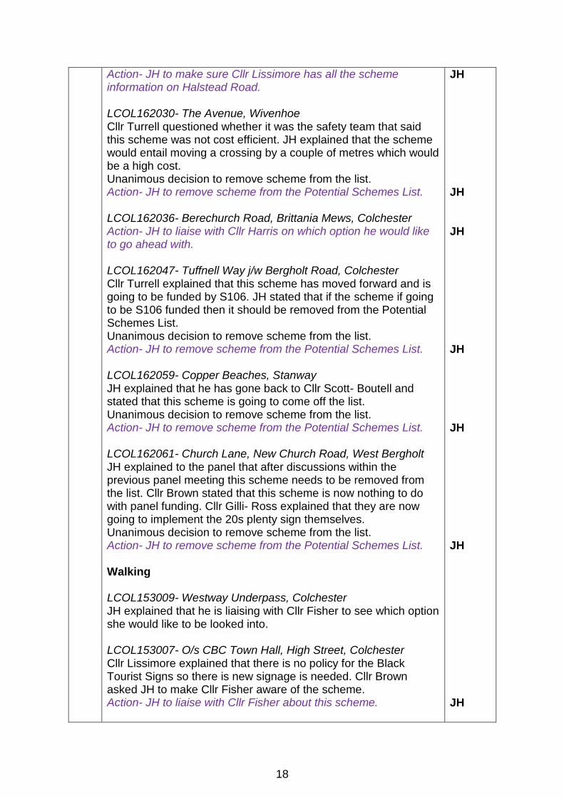
Action- JH to make sure Cllr Lissimore has all the scheme information on Halstead Road. LCOL162030- The Avenue, Wivenhoe Cllr Turrell questioned whether it was the safety team that said this scheme was not cost efficient. JH explained that the scheme would entail moving a crossing by a couple of metres which would be a high cost. Unanimous decision to remove scheme from the list. Action- JH to remove scheme from the Potential Schemes List. LCOL162036- Berechurch Road, Brittania Mews, Colchester Action- JH to liaise with Cllr Harris on which option he would like to go ahead with. LCOL162047- Tuffnell Way j/w Bergholt Road, Colchester Cllr Turrell explained that this scheme has moved forward and is going to be funded by S106. JH stated that if the scheme if going to be S106 funded then it should be removed from the Potential Schemes List. Unanimous decision to remove scheme from the list. Action- JH to remove scheme from the Potential Schemes List. LCOL162059- Copper Beaches, Stanway JH explained that he has gone back to Cllr Scott- Boutell and stated that this scheme is going to come off the list. Unanimous decision to remove scheme from the list. Action- JH to remove scheme from the Potential Schemes List. LCOL162061- Church Lane, New Church Road, West Bergholt JH explained to the panel that after discussions within the previous panel meeting this scheme needs to be removed from the list. Cllr Brown stated that this scheme is now nothing to do with panel funding. Cllr Gilli- Ross explained that they are now going to implement the 20s plenty sign themselves. Unanimous decision to remove scheme from the list. Action- JH to remove scheme from the Potential Schemes List. Walking LCOL153009- Westway Underpass, Colchester JH explained that he is liaising with Cllr Fisher to see which option she would like to be looked into. LCOL153007- O/s CBC Town Hall, High Street, Colchester Cllr Lissimore explained that there is no policy for the Black Tourist Signs so there is new signage is needed. Cllr Brown asked JH to make Cllr Fisher aware of the scheme. Action- JH to liaise with Cllr Fisher about this scheme.
JH JH JH JH JH JH JH
18
10. Rangers Cllr Brown explained that she had a meeting with Cllr Johnson and he has sent and officer off to see what was being done. It has also been mentioned that they are going to provide an officer for the January Panel Meeting to discuss the rangers work. As members need to understand where there revenue budget is being spent and that works are actually being completed. Cllr Willets explained that Colchester Borough Council did not wish to take on the rangers unless it was a fixed five year contract so they decided not to go ahead. Cllr Gilli-Ross stated that he does not believe they want anything to do with the rangers as they normally offer a three year contract.
11 Date of next panel meeting 10th January 2017
19
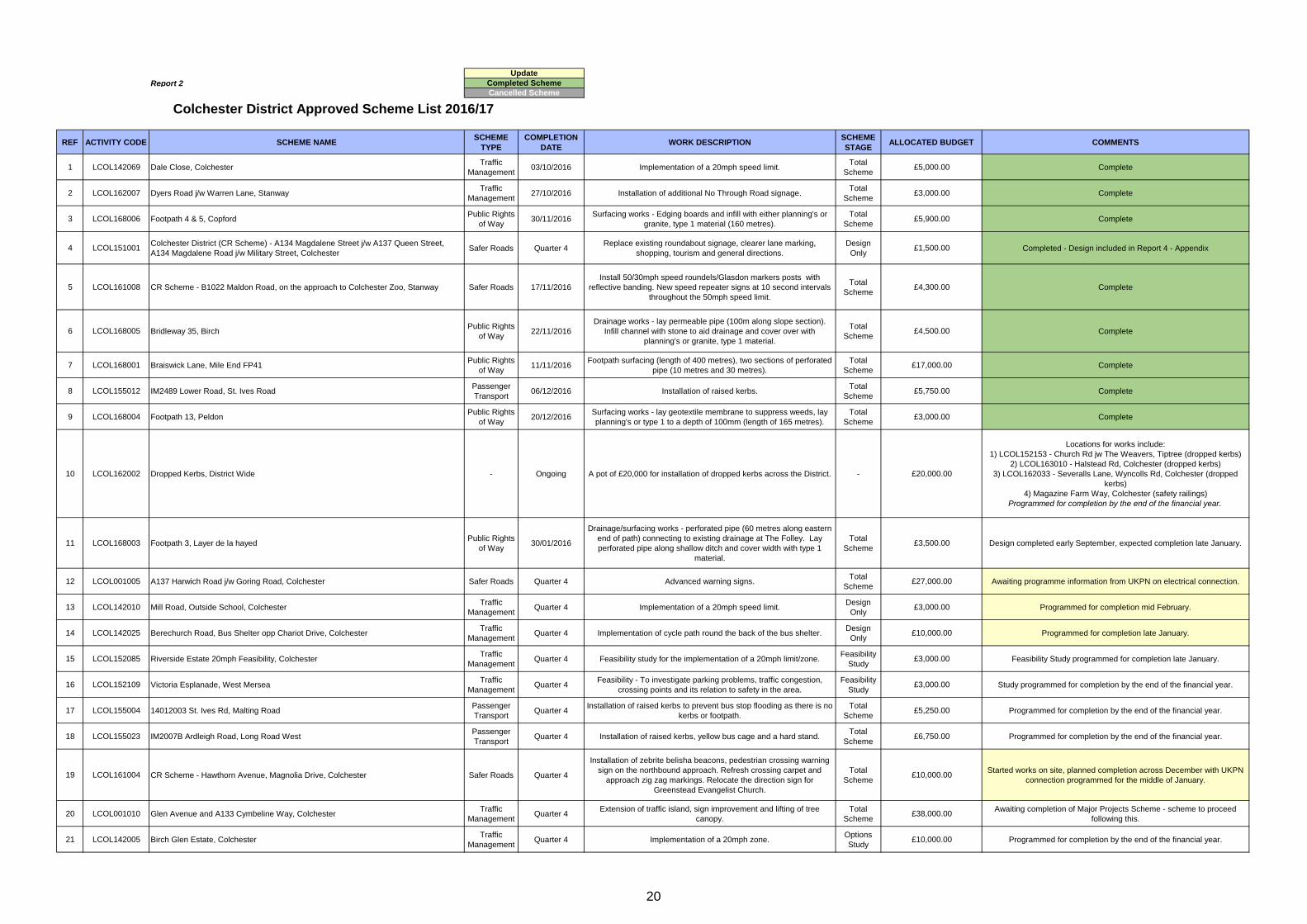
Report 2
REF ACTIVITY CODE SCHEME NAMESCHEME
TYPE
COMPLETION
DATEWORK DESCRIPTION
SCHEME
STAGEALLOCATED BUDGET COMMENTS
1 LCOL142069 Dale Close, ColchesterTraffic
Management03/10/2016 Implementation of a 20mph speed limit.
Design of cycle route between Thomas Lord Audley School to
Gurdon Road.
Design
Only£10,000.00 Scheme to progress 2017/18
56 LCOL162008 Brook Road, Great TeyTraffic
Management
2017/18
Financial Year
Installation of carriageway roundels/dragons teeth markings at
gateway.
Total
Scheme£3,000.00 Scheme to progress 2017/18
57 LCOL155005 TEMP0018 St. Ives Rd, Church RoadPassenger
Transport-
Installation of raised kerbs to prevent bus stop flooding as there is no
kerbs or footpath.
Total
Scheme£5,250.00
Scheme cancelled - Kerbing unable to be installed due to flooding
aspects.
22
COLCHESTER DISTRICT COUNCIL WITH ESSEX COUNTY COUNCIL
LOCAL HIGHWAY PANEL – 10TH JANUARY 2017 2016/17 POTENTIAL CAPITAL SCHEMES
As part of the Essex County Council 2017/18 budget it is believed that the Capital budget for the Colchester District Local Highways Panels (LHP) will remain the same as that for 2016/17. This would mean for Colchester District LHP the available 2017/18 capital budget would be £500,000. It is recommended for 2017/18 that the Panel make further scheme funding recommendations to create a £700,000 rolling programme of highway improvement works.
2017/18 Budget Summary
Item Amount
Capital Funding 2017/18 £500,000
Recommended Rolling Programme 2017/18 (140%)
£700,000
Programmed Works re-profiled from 2016/17 into 2017/18
£88,000
Capital funding available to make recommendations against in 2017/18
£612,000
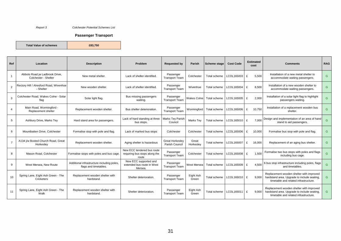
Report 3
23
COLCHESTER DISTRICT COUNCIL WITH ESSEX COUNTY COUNCIL
LOCAL HIGHWAY PANEL – 10TH JANUARY 2017 2016/17 POTENTIAL CAPITAL SCHEMES
This Potential Scheme List identifies all the scheme requests which have been received for the consideration of the Colchester District Local Highways Panel. The Panel are asked to review the schemes on the attached Potential Scheme List, making funding recommendations against those they wish to see implemented and remove any schemes the Panel would not wish to consider for future funding. On the Potential Schemes List, there are currently potential schemes with an estimated £258,250 as shown in the summary below:
Potential Schemes List
Scheme Type Total Estimated Costs
Safer Roads £12,000
Traffic Management £105,000
Passenger Transport £83,750
Cycling £18,000
Public Rights of Way £22,000
Walking £17,500
Total £258,250
RAG Status Description of RAG Status
G The scheme has been validated as being feasible and is available for consideration.
A The scheme has previously been approved for design only/feasibility study and the results are awaited before the scheme can be fully considered.
R The scheme request is against ECC criteria.
A scheme request has been received and is in the initial validation process/awaiting survey information.
Report 3
24
Report 3 Colchester Potential Schemes List
Safer Roads
Total Value of schemes £12,000
Ref Location Description Requested by Parish Scheme stage Cost CodeAllocated
BudgetComments RAG
1
A133 Colne Bank Road j/w A134
Westway/Cowdray Avenue/North
Station Road, Colchester - Traffic
management improvements
Signing and lining improvements. Road Safety Team Abbey Implementation LCOL161011 TBC
Awaiting RSA 1 & 2 as well as Level 1 Estimate.
Expected to be presented to the Panel at the end
of April 2017.
A
2
A134 Westway, 200m North West
of jct with Middleborough
Roundabout - Traffic management
improvements
Signing and lining improvements. Road Safety Team Abbey Implementation LCOL161012 £ 12,000
Implementation of new yellow backed 40mph
repeater signs with junction ahead warning sign.
40mph carriageway roundels and SLOW markings
to be placed on the carriageway.
G
25
Report 3 Colchester Potential Schemes List
Traffic Management
Total Value of schemes £105,000
Ref Location Description Problem Requested by Parish Scheme stage Cost CodeEstimated
costComments RAG
1Wash Corner, Fordham - Traffic
calming measuresSpeed reduction measures.
Accidents involving cars leaving
the road have been identified.Cllr Brown Fordham Total scheme LCOL152022 £ 3,000
Validation - Following a meeting on site, the Parish
agreed that an additional chevron warning sign would
assist. Accompanied by vegetation removal.
G
2Church Lane, Stanway - Weight
restrictionWeight limit restriction.
HGV's travelling down narrow
Lane.Cllr Scott Boutell Stanway Feasibility LCOL152023 TBC In validation
3Church Road near Asda Store, Tiptree -
Ped crossing
Design and implementation of
controlled crossing point.Pedestrians crossing the road.
Tiptree Parish
CouncilTiptree Design LCOL152156 TBC In validation
4Mill Road, Mile End - Implementation of
20mph limit
Design and implementation of a
20mph speed limit.Speeding outside the school. Cllr Turrell Myland Implementation LCOL162041 TBC Awaiting completed design. Expected mid February. A
Street, Colchester - SignageTown house youth centre signage.
Lack of signs to encourage
people to walk to Youth
Centre
Cllr HarrisColchester
Town CentreTotal scheme LCOL153007 £ 2,500
Validation - Recommended to design & implement requested
signage.G
7The Commons, Colchester -
Ped crossing
Design and implementation of
controlled crossing point.
Pedestrians have expressed
difficulty crossing the road.Cllr Lissimore Prettygate Implementation LCOL163004 TBC
Survey budget exhausted. To leave on the Potential Schemes
List until the budget has refreshed.
8Stable Road, Colchester -
BollardInstallation of two bollards. Vehicles using the footway. Cllr Lissimore Christ Church Total scheme LCOL163009 N/A
DYL are present along North Circular Road. Other dropped
kerb locations have been identified. Vehicles can bump up the
kerb line at any point or use the other dropped kerb locations
to access the grass verges. The installation of bollards here is
likely to have little to no effect.
R
9Berechurch Hall Road,
Colchester - Footpath
Design and implementation of
footpath link.Lack of footway identified. Cllr Harris Colchester Design LCOL163014 TBC In validation
10
Circular Road North opp Stable
Road, Colchester - Crossing
point
A lack of pedestrian and cycling
crossing facilities is causing issues
when attempting to cross Circular
Road North.
Pedestrians and cyclist alike
experiencing difficulties
crossing the road.
Cllr Cope Colchester
LCOL163015 TBC
Information to be compiled and validation request to be sent to
officer.
30
Report 3 Colchester Potential Schemes List
Passenger Transport
Total Value of schemes £83,750
Ref Location Description Problem Requested by Parish Scheme stage Cost Code Estimated
cost Comments RAG
1Abbots Road jw Ladbrook Drive,
Colchester - ShelterNew metal shelter. Lack of shelter identified.
Passenger
Transport TeamColchester Total scheme LCOL165003 £ 5,500
Installation of a new metal shelter to
accommodate waiting passengers.G
2Rectory Hill / Alresford Road, Wivenhoe
- ShelterNew wooden shelter. Lack of shelter identified.
Passenger
Transport TeamWivenhoe Total scheme LCOL165004 £ 8,500
Installation of a new wooden shelter to
accommodate waiting passengers.G
3Colchester Road, Wakes Colne - Solar
flagSolar light flag.
Bus missing passengers
waiting.
Passenger
Transport TeamWakes Colne Total scheme LCOL165005 £ 2,000
Installation of a solar light flag to highlight
passengers waiting.G
4Main Road, Wormingford -
Replacement shelterReplacement wooden shelter. Bus shelter deterioration.
Passenger
Transport TeamWormingford Total scheme LCOL165006 £ 10,750
Installation of a replacement wooden bus
shelter.G
5 Ashbury Drive, Marks Tey Hard stand area for passengers.Lack of hard standing at three
bus stops.
Marks Tey Parish
CouncilMarks Tey Total scheme LCOL165010 £ 7,000
Design and implementation of an area of hand
stand to aid passengers.G
6 Mountbatten Drive, Colchester Formalise stop with pole and flag. Lack of marked bus stops Colchester Colchester Total scheme LCOL165006 £ 10,000 Formalise bus stop with pole and flag. G
7A134 j/w Boxted Church Road, Great
HorkesleyReplacement wooden shelter. Aging shelter is hazardous
Great Horkesley
Parish Council
Great
HorkesleyTotal scheme LCOL165007 £ 16,000 Replacement of an aging bus shelter. G
8 Mason Road, Colchester Formalise stops with poles and bus cage.
New ECC tendered bus route
requiring bus stops along the
route
Passenger
Transport TeamColchester Total scheme LCOL165008 £ 1,500
Formalise two bus stops with poles and flags
including bus cage.G
9 West Mersea, New RouteAdditional infrastructure including poles,
flags and timetables.
New ECC supported and
extended bus route in West
Mersea.
Passenger
Transport TeamWest Mersea Total scheme LCOL165009 £ 4,500
6 bus stop infrastructure including poles, flags
and timetables.G
10Spring Lane, Eight Ash Green - The
Cricketers
Replacement wooden shelter with
hardstand.Shelter deterioration.
Passenger
Transport Team
Eight Ash
GreenTotal scheme LCOL165010 £ 9,000
Replacement wooden shelter with improved
hardstand area. Upgrade to include seating,
timetable and related infrastructure.
G
11Spring Lane, Eight Ash Green - The
Walk
Replacement wooden shelter with
hardstand.Shelter deterioration.
Passenger
Transport Team
Eight Ash
GreenTotal scheme LCOL165011 £ 9,000
Replacement wooden shelter with improved
hardstand area. Upgrade to include seating,
timetable and related infrastructure.
G
31
Report 3 Colchester Potential Schemes List
Cycling
Total Value of
schemes£18,000
Ref Location Description ProblemRequested
byParish
Scheme
stageCost Code
Estimated
cost Comments RAG
1
Blackberry Road /
Holly Road,
Stanway - Cycling
furniture
Implementation of staggered
barriers, mirror and signage.
Pedestrians and
cyclists colliding on
link footway.
Stanway
Parish
Council
Stanway Total scheme LCOL154004 £ 18,000
Validation - Recommended staggered barriers, making
cyclists slow down at these sections or even dismount.
Mirrors and signage is preferred by the Parish to allow
forward visibility around the corners, giving pedestrians
and cyclists the chance to see what’s coming and
signage could be installed asking cyclists to dismount.
G
2
Circular Road North
by jw Flagstaff Rd,
Colchester - Tiger
Crossing
Possibility of a tiger crossing. Cycle
routes either sides of the junction,
would be useful to link up the
routes.
Cyclists having
issues crossing the
road. Lack of cycle
route link identified.
Cllr Barton Colchester Design LCOL164004 TBCAwaiting implementation of Circular Road North jw
Goojerat request before proceeding with the request.
32
Report 3 Colchester Potential Schemes List
Public Rights of Way
Total Value of schemes £22,000
Ref Location Description Problem Requested by ParishScheme
stageCost Code
Allocated
BudgetComments RAG
1RBY 243, Colchester - Access
to Roach Vale School
Implementation of blacktop surfacing
and gully's.Byway deterioration. Cllr Smith Colchester Total scheme LCOL168007 £ 6,000
150m excavation in the over-run, bedding and pipe, 8
gully's, blacktop over piping, overrun to give required
width of 0.5m.
G
2FP20, West Mersea - Surfacing
works
Implementation of blacktop surfacing
for entire length.
Large water deposits are
often found along the
surface. Request calls for
resurfacing, possible
drainage.
PROW Team West Mersea Total scheme LCOL168008 £ 6,000 1.5m in width, approx. 365m in length, vegetation cut
back with blacktop resurface.G
3 Byway 47, Dedham
Remove damaged brick bridge and
replace with piped culvert crossing.
Repair/install drainage running
between the northern end and Black
Brook, lay plainings same length.
Build up the existing culvert crossing
and pipe the adjacent ditch.
Poor drainage, overgrown
vegetation, damaged
bridge, unsuitable surface
condition.
PRoW Team Dedham Total scheme LCOL168011 £ 10,000
Remove damaged brick bridge and replace with a
piped culvert crossing.
Repair/install drainage running between the northern
end and Black Brook and lay plainings along the the
same length.
Build up the existing culvert crossing and pipe the
adjacent ditch (18m) so it is wide enough to
accommodate a vehicle.
G
33
Report 4 – Appendix
1) Section 106 Update
2) Colchester Ranger Report
3) Completed Designs
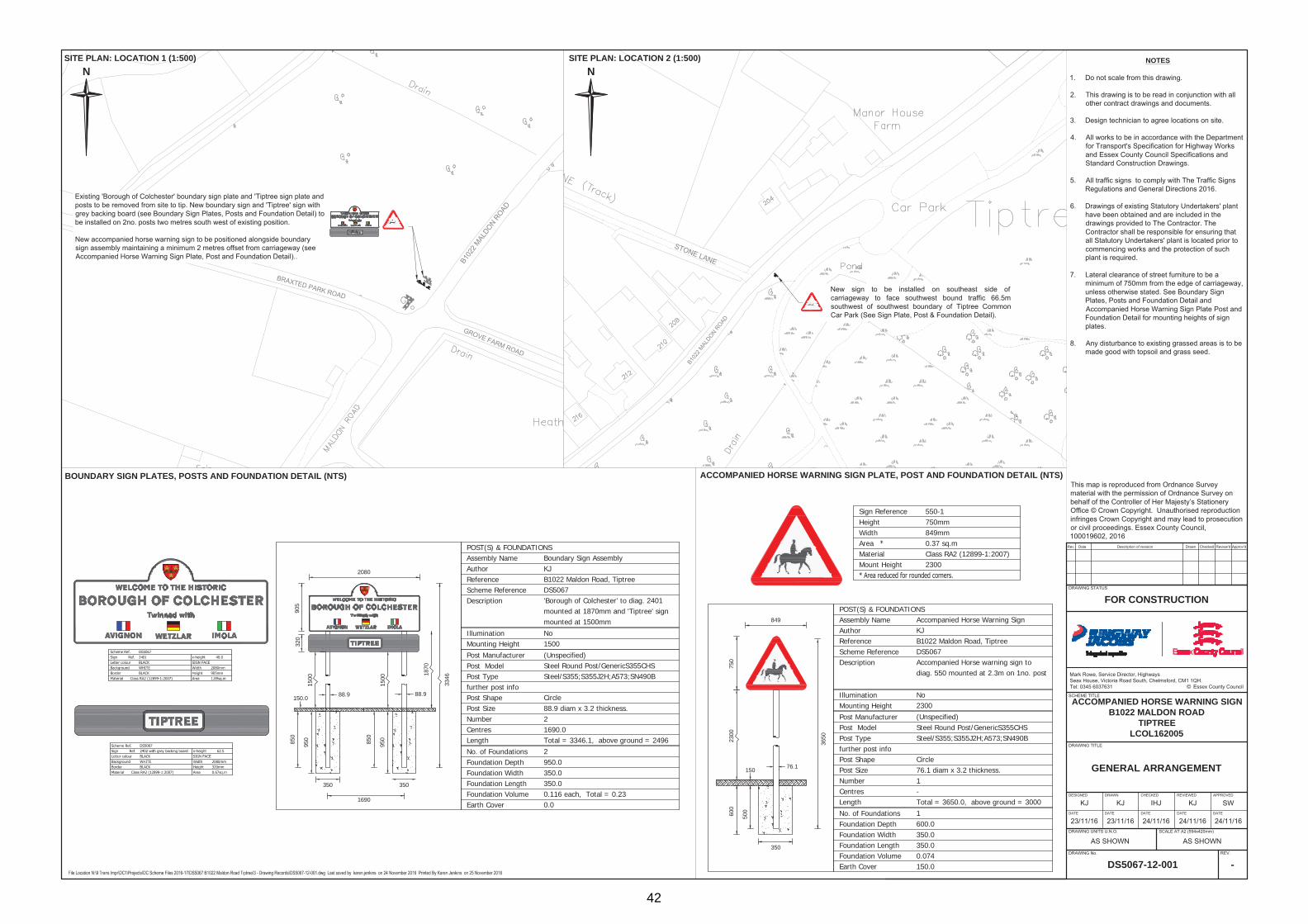
- LCOL151001 - Artillery Street, Colchester
- LCOL151002 - A134 Southway w bound app to RABT with B1022 -
A1124
- LCOL162005 - B1022 Maldon Road, Tiptree
34
Colchester LHP Section 106 Update
Current Stage Task Name Cost Code Delivery Method Works Description Comments
In ProgressNorthfields to Turner Road Link,
ColchesterHB13056 Supply Chain Partner
New pedestrian / cycle link from Northfields to Turner Road,
Colchester.Start date 5th December 2016.
In ProgressPassenger Transport infrastructure
improvementsHB16016 Supply Chain Partner
To carry out PT improvements as necessary in vicinity of
site.
To be delivered by the end of the 2016/17
financial year.
In ProgressBoadicea Way to Drury Road,
cyclewayHB16017 Design only Provide a cycleway from Boadicea Way to Drury Road. In validation.
In Progress
Rectory Road, Wivenhoe Passenger
Transport infrastructure
improvements
HB16018 Design onlyTo carry out PT improvements as necessary in vicinity of
site.Design in progress.
In Progress Mill Road, Colchester HB12053 Design only Mill road, mile end - traffic calming measuresDesign in progress. To be completed by the
end of the financial year.
35
Report 4
Colchester LHP Rangers Report
Ref Site Name Area Name Defect Description Defect Location Job Entry DateJob Completion
Date
1 Peldon Road Abberton Rangers sign post obscured by vegetation which require cleaning. Opposite Abbey Wood. 03/07/2015 10/10/2016
2 Coast Road West Mersea Vegetation encroaching footpath and barrier. Coast Inn to opposite No. 102. 06/08/2015 13/10/2016
3 Straight Road Boxted Overgrown trees obscuring sight of school warning sign. Approx. 100 x 3 x 2. Opposite Avocet. 30/10/2015 14/11/2016
4 Factory Hill Tiptree Approx. 40m weeds and bushes encroaching on footway. Between Brook Hall and The Brook. 13/11/2015
7 Church Road Tiptree Vegetation encroaching on footway. Approx. 30m. Between Grove Road and St. John's Catholic Church. 13/11/2015 10/11/2016
8 Church Road Tiptree Vegetation encroaching over highway. Traffic management required foe flailing. Outside No. 6. 13/11/2015 10/11/2016
9 Kelvedon Road Messing Cum Inworth Vegetation encroaching 30mph signage. Vegetation partially cut back by inspectors. Between Inworth Hall Villa and The Laurels. 19/11/2015 11/11/2016
10 Glebe View West Mersea Loose block. On the junction of Glebe View and Bower Grove. 19/11/2015 15/11/2016
11 Colchester Road Chappel Cut back vegetation around 30mph signage. Entrance to Ford Street. 24/08/2016 11/11/2016
12 Halstead Road Stanway Overgrown vegetation on footway. From Lucy Lane North to Iron Latch Lane . 31/08/2016 25/10/2016
13 Broom Way Abberton Vegetation encroaching on footway. Along footway side of 4 Kingfisher Cottage to side of No. 26 Broomway. 09/09/2016 11/10/2016
14 Ford Street Aldham Cut back vegetation at the back of the footway 100. Opposite The Shoulder of Mutton. 09/09/2016 12/10/2016
15 Luard Way Birch Clearance of moss from the footway. Outside No. 19. 09/09/2016 14/10/2016
16 Birch Park Birch Weight restriction signage reported dirty. Adjacent bridge on the layer side. 09/09/2016 14/10/2016
17 Garlands Road Birch Weed growth on verge, restricting sight line when turning into Birch Park . Approx. 20yards. Opposite junction with Birch Park. 09/09/2016 13/10/2016
18 Cross Cottages Boxted Hedge overgrown over footway. Approx. 40 x 2 x 2. To the side of No. 24. 09/09/2016 10/10/2016
19 London Road Copford Leaf mould and dirt along back edge. Approx. 25m Adjacent to Hall Road by The Kipps. 09/09/2016 10/10/2016
20 East Road Colchester Overgrown vegetation. 16m requires cutting back past kerb. Opposite No. 8. 12/09/2016 25/10/2016
21 East Road East Mersea 30mph speed limit sign sprayed over, to be cleaned. Opposite Latimer. 12/09/2016 27/10/2016
22 Wood Lane Eight Ash Green Cut back vegetation in site line. Approx. 8 x 0.4. Outside Briars. 12/09/2016 14/10/2016
23 Coach Road Great Horkesley Overgrown vegetation over signage. Approx. 60 x 2 x 2. Opposite Wood House Lodge. 12/09/2016 18/10/2016
24 Coach Road Great Horkesley Vegetation over footway. Approx. 15 x 5 x 1. Opposite the entrance to Bishop William Ward School. 12/09/2016 18/10/2016
25 Nayland Road Great Horkesley 30mph sign obscured by vegetation. Approx. 1 x 1 x 1. Junction with Green Lane. 12/09/2016 14/10/2016
26 Horkesley Hill Great Horkesley Vegetation overgrown over footway. Approx. 150 x 1 x 3. 200m south of Rose and Crown. 12/09/2016 19/10/2016
27 Ivy Lodge Road Great Horkesley Overgrown vegetation, obscuring village sign. Approx. 20 x 2 x 1. 20m from Laburnum House. 12/09/2016 28/10/2016
28 Grange Road Great Horkesley Hedge overgrown over footway. Approx. 40 x 2 x 1. Opposite No. 17. 12/09/2016 28/10/2016
29 Blackbrook Road Great Horkesley Overgrown vegetation over footway hedging. Approx. 25 x 2 x 1. Opposite Helm Close. 12/09/2016 19/10/2016
30 Park Road Great Horkesley Stones pile on carriageway. Approx. 2 x 1 x 50. Junction with The Causeway. 12/09/2016 14/10/2016
31 The Causeway Great Horkesley Grass growing on footway. Approx. 1 x 1 x 30. Opposite No. 18. 13/09/2016 18/10/2016
36
Report 4
Colchester LHP Rangers Report
Ref Site Name Area Name Defect Description Defect Location Job Entry DateJob Completion
Date
32 The Causeway Great Horkesley Vegetation overgrown over footway. Approx. 120 x 1 x 3. Opposite Gulf Garage, Tile House Lane. 13/09/2016 18/10/2016
33 The Causeway Great Horkesley Verge overgrown over footway. Approx. 10 x1 x 1. Outside Rookery House. 13/09/2016 18/10/2016
34 Chrismund Way Great Tey Cut back vegetation. Approx. 8 x 0.8. At the side of No. 7. 13/09/2016 13/10/2016
35 St Clare Road Colchester Weeds at kerb edge throughout the road. Throughout the entire road. 14/09/2016 17/10/2016
36 Sheepen Road ColchesterOvergrown vegetation and leaf debris on footway / cycleway.
Heavy foot traffic as path between rail station and Sixth Form College.Side of school football pitches between lamp column 22 - 25. 14/09/2016 14/11/2016
37 Arbour Way Colchester Tree overgrown near lamp column. Approx. 6 x 3 x 4. Opposite No. 22. 14/09/2016 02/11/2016
38 Cowdray Avenue Colchester Remove debris and side out cycleway / footway to full width of metalled path. Approx. 150m. From service road exit. Opposite No. 340. 14/09/2016 24/10/2016
39 Bracken Way Abberton Vegetation encroaching on footway. Approx. 4.0m. Between No. 22 and The School. 15/09/2016 11/10/2016
40 Grosvenor Close Tiptree Weed growth, brambles, stinging nettles. Approx. 50yards. Entire length of footway. 15/09/2016 14/10/2016
41 Grove Road Tiptree Vegetation restricting sight line of pedestrians entering road from the footway. Close to the barrier where Tew Close has a pedestrian exit into Grove Road. 15/09/2016 17/10/2016
42 Grove Road Tiptree Vegetation encroaching on highway. Between No. 73 and No. 79. 15/09/2016 17/10/2016
43 Grove Road Tiptree Vegetation starting to encroach on footway. Approx. 15 yards. Between No. 17 and Green Lane. 15/09/2016 17/10/2016
44 Balkerne Hill Colchester No Cycling sign requires cleaning and removal of stickers. Entrance to Middleboro subway, northbound on Roman Wall side. 16/09/2016 10/10/2016
45 Church Lane Colchester Overgrown vegetation on footway. From the entrance to the Country Park to Parsons Hill. 16/09/2016 03/11/2016
46 Newcomen Way Colchester Hegde overgrown over footway. Approx. 30 x 5 x 1. Opposite Ford Garage. 16/09/2016 20/10/2016
47 Albert Street Colchester Clear weed growth from both sides of footpath. Approx. 25m. Entire length on both sides of Albert Street. 16/09/2016 10/10/2016
48 Wyncolls Road Colchester Vegetation overgrown on footway 20 x 1 x 2. Outside N & C. 19/09/2016 02/11/2016
49 Haven Road Colchester Siding out needed at back of the footway. Approx. 150 x 0.5 x 20.Between Distillery Lane and the roundabout at the Colne Causeway.
Opposite new build at the Maltings.19/09/2016 10/10/2016
50 Bromley Road Colchester Vegetating overgrown over footway. Approx. 80 x 2 x 2. Opposite Longridge. 19/09/2016 19/10/2016
51 Mossfield Close Colchester Weeds at kerb edge throughout the road. Entire length of road. 19/09/2016 07/11/2016
53 Birch Road Layer De La Haye Vegetation encroaching onto highway. Approx. 5m. Land adjacent to No. 1 Mulberry Cottage towards the cross roads. 19/09/2016 16/11/2016
54 Church Lane Marks Tey Verge area with weed growth . Approx. 35m. Between junction and entrance to Global. 20/09/2016 13/10/2016
55 Kelvedon Road Messing Cum Inworth Vegetation encroaching on footway. Approx. 20 yards. Adjacent to Well Cottage. 20/09/2016 17/10/2016
56 Thornton Drive Myland Weeds growing at side of footway. Approx. 200 x 1. Entire length of Thornton Drive. 20/09/2016 08/11/2016
57 Northern Approach Road Myland Hedge overgrown over footway. Approx. 70 x 2 x 1. Either side of Gruff Close junction. 20/09/2016 20/10/2016
58 Oxley Parker Drive Myland Hedge overgrown over footway 15 x 2 x 1. Outside No. 2 - 6 / junction with Mill Road. 20/09/2016 01/11/2016
59 Peto Avenue Myland Hedges and weeds overgrowing at the side of the footway. Approx. 200 x 1. Entire length of Peto Avenue. 20/09/2016 25/10/2016
60 Bartholomew Court Myland Overgrown vegetation over footway. Approx. 10 x 2 x 1. Opposite lamp column 3. 20/09/2016 01/11/2016
61 Axial Way Myland Tree overgrown over footway / cycleway. Approx. 2 x 1 x 1. 10m from Severalls Lane junction. 20/09/2016 11/10/2016
62 Stanford Road Myland Overgrown vegetation over footway hedge. Approx. 20 x 2 x 1. Outside No. 2. 20/09/2016 08/11/2016
37
Report 4
Colchester LHP Rangers Report
Ref Site Name Area Name Defect Description Defect Location Job Entry DateJob Completion
Date
63 Cornflower Close Stanway Overgrown vegetation at kerb edge throughout the whole road. Entire length of road. 20/09/2016 03/11/2016
64 Chitts Hill Stanway Overgrown vegetation on footpath. Approx. 35m. From junction with Halsted Road to corner of the footbridge. 20/09/2016 12/10/2016
65 Warren Lane Stanway 30mph totally obscured by vegetation upon entrance to speed limit. 100m from junction with Maldon Road. 20/09/2016 13/10/2016
66 Warren Lane Stanway Dirty double S bend and 30mph signage. Opposite No. 24. 20/09/2016 13/10/2016
67 Mill Road Myland Hedge overgrown over footway / cycleway. approx. 30x 3 x 1. By the roundabout with Maximus Drive. 21/09/2016 21/10/2016
68 Mill Road Myland Vegetation over footway. Approx. 10 x 5 x 2. Opp Bedford Road, opposite No. 190. 21/09/2016 21/10/2016
69 Mill Road Myland Vegetation overgrown over footway. Approx. 50 x 1 x 3. At the junction with Maximus Drive. 21/09/2016 21/10/2016
70 London Road Stanway Overgrown hedges on footway.London Road from junction with Lucy Lane, south to bus shelter opposite
Millers Lane.21/09/2016 21/10/2016
71 Layer Road Stanway Overgrown vegetation obscuring vision for resident exiting driveway. Outside entrance to Kingsgrove. 21/09/2016 24/10/2016
72 Bailey Drive Stanway Overgrown vegetation obstructing street lamp. Bailey Dale, tree near to lamp column 2. 21/09/2016 07/11/2016
73 Maldon Road Tiptree Vegetation encroaching on footway, trim and side approx. 15m.Opposite pedestrian gate into school playground. Between bus stop and
Peakes Close.21/09/2016 17/10/2016
74 Maldon Road Tiptree Vegetation starting to encroach footway. Approx. 3m Between Brook Meadows and Clarksmead. 21/09/2016 17/10/2016
75 Messing Road Tiptree Vegetation starting to encroach footway. Approx. 3m Between Elms Farm and junction with Maypole Road. 21/09/2016 13/10/2016
76 Colchester Road Wakes Colne Cut back vegetation at the back of the footway. Approx. 300m. Between Lane Road and The Village Hall. 21/09/2016 04/11/2016
77 Firs Chase West Mersea Part of verge encroaching on the carriageway. From the Yacht Club to City Road. 21/09/2016 11/10/2016
78 Firs Chase West Mersea Clear growth at back of the footway by the fence line. Side of No. 25 Rosebank Road. 21/09/2016 11/10/2016
79 Firs Road West Mersea Cut back overgrown nettles. Junction of Firs Chase and Rosebank Road. 21/09/2016 10/10/2016
80 Firs Hamlet West Mersea Remove moss from footway surface and side out to clear weed growth. Outside No. 5 & 6. 21/09/2016 10/10/2016
81 Victory Road West Mersea Footway requires siding out and moss growth removal. Approx. 30m. Side of Victory Public House. 21/09/2016 26/10/2016
82 Wellhouse Avenue West MerseaCut back shrub beds both sides of path. Approx. 50m. Overgrowing path and narrowing to
about 2ft in places.
Path to the right hand side of Wellhouse Avenue from East Road up to
garage entrance of No. 2.21/09/2016 11/10/2016
83 East Mersea Road West Mersea Sign needs cleaning, spray paint removal. 50m before junction with the The Strood. 21/09/2016 27/10/2016
84 Brinkley Grove Road Colchester Vegetation overgrown over footway. Approx. 45 x 2 x 1. Outside No. 7. 21/09/2016 21/10/2016
85 Great Tey Road Marks Tey Vegetation encroaching on footway. Approx. 5 m. At junction with Coggeshall Road. 21/09/2016 13/10/2016
86 Circular Road North Colchester Overgrown vegetation on traffic island. Junction with Circular Road West. 21/09/2016 28/10/2016
87 Circular Road North Colchester Overgrown vegetation at kerb edge. From the junction with Le Cateau Road to the junction with Flagstaff Road. 21/09/2016 28/10/2016
88 Circular Road North Colchester Overgrown vegetation from trees obstructing the footway and carriageway. From junction with Le Cateau road to junction with Stable Road. 21/09/2016 28/10/2016
89 Churnwood Road Colchester Overgrown vegetation over footway. Approx. 40 x 2 x 1. Opposite No. 15. 21/09/2016 31/10/2016
90 Rowhedge Road Colchester Back of footway requires siding out. From No. 171 to Rowhedge Village. 21/09/2016 18/11/2016
91 Gavin Way Colchester Overgrown vegetation over footway. Approx. 10 x 4 x 2. Opposite Park Church. 21/09/2016 14/10/2016
92 Brinkley Lane Colchester Vegetation overgrown over footway. Approx. 110 x 2 x 1. Opposite No. 8 - 20. 21/09/2016 26/10/2016
93 Footpath 200 Colchester Colchester Overgrown vegetation on footpath. Entire length of footway. 04/10/2016 10/11/2016
38
Report 4
Colchester LHP Rangers Report
Ref Site Name Area Name Defect Description Defect Location Job Entry DateJob Completion
Date
94 Gavin Way Colchester Hegde over footway. Approx. 50 x 3 x 1. 10m north of Asquith Drive. 06/10/2016 17/11/2016
95 Gavin Way Colchester Hegde over footway. Approx. 3 x 3 x 1. Outside No. 55. 06/10/2016 17/11/2016
96 Southway Westbound Colchester Overgrown vegetation obstructing footway. Approx. 12m. Close to pedestrian crossing at bottom of Hospital Lane. 17/10/2016 21/11/2016
97 Myland Hall Chase Colchester Hegde over footway. Approx. 10 x 3 x 1. Outside No. 2. 17/10/2016 21/11/2016
98 Sage Walk Tiptree Vegetation growth over footway Approx. 20m. Between No.10 and No. 16. 17/10/2016 18/11/2016
99 Maldon Road Birch Vegetation encroaching footway. Approx. 100yards. Between Heckford Cottage and Fountain Lane. 17/10/2016 18/11/2016
100 Launceston Close Colchester Moss growing on footway. Approx. 50 x 1.8. Outside No. 20. 18/10/2016 15/11/2016
101 Launceston Close Colchester Moss growing on footway. Outside No. 4 to No. 6. 18/10/2016 15/11/2016
102 Braiswick Colchester Vegetation overgrown over footway. Approx. 10 x 2 x 1. Opposite No. 12. 19/10/2016 21/11/2016
103 High Road Layer De La Haye Vegetation overhanging, brambles and stinging nettles. New cut/Highroad. 19/10/2016 09/11/2016
104 Colne Causeway ColchesterShrubs overgrowing footway section by up to 70%. Required to cut back and side out for
approx. 120m.
North side between the bridge and Travis Perkins at Hawkins Road
roundabout.21/10/2016
105 Church Road Tiptree Vegetation encroaching on highway. Approx. 60 yards. Opposite underwood's garage towards Mill Close. 21/10/2016
106 Cleveland Close Colchester Hedge and vegetation overgrown over footway. Approx. 100 x 1 x 1. Entire length of Clevand House. 25/10/2016 09/11/2016
107 Chinook Colchester Vegetation overgrown on footway. Approx. 15 x 3 x 2. Outside No. 14. 26/10/2016
108 Berechurch Road Colchester Overgrown vegetation nearside of road. Between Gurdon road and Queen Mary Avenue. 01/11/2016 17/11/2016
109 Berechurch Road Colchester Overgrown vegetation on verge at entrance to the gym. At junction for Corporal Budd Gym Merville Barracks. 01/11/2016 17/11/2016
110 Church Road Tiptree Vegetation encroaching on and around bench. Adjacent to No. 1. Opposite No. 32. Close to Station Road. 01/11/2016
111 Queensland Drive Colchester Footway requires siding out / moss removal on both sides. Approx. 40m. Whole length , remote path running to No. 147 from main footway. 02/11/2016 15/11/2016
112 Townsend Road Tiptree Vegetation encroaching on highway and covering sign. Approx. 4m. Opposite No. 40. 03/11/2016 16/11/2016
113 Vine Road Tiptree Vegetation encroachment on highway. Approx. 120m. Between Vine Barn and Grange Road. 07/11/2016
114 Northern Approach Road Myland 40mph sign reported as dirty. 20m from roundabout with Boxted Road. 15/11/2016
115 Herrick Place Colchester Overgrown vegetation on footpath. Footway beside No. 4 close to Herrick Place to Church Lane. 16/11/2016
117 Braiswick Colchester Give way and roundabout signage reported dirty. Outside No. 86. 28/11/2016
118 Braiswick Colchester Vegetation over footway. Approx. 5 x 2 x 1. Opposite No. 18. 28/11/2016
119 St Andrews Gardens Colchester Vegetation, brambles and nettles over footway. Approx. 15 x 2 x 2. Towards the back of No. 43. 08/12/2016
120 King Coel Road ColchesterOvergrown vegetation hedge bordering No. 26 protruding into carriageway for a distance of
48m.Outside No. 26. 08/12/2016
121 Cleveland Close Colchester Overgrown hedge, obscuring street light. Approx. 5 x 2. Outside No. 442 Ipswich Road. 08/12/2016
122 Cooks Hill Boxted Weeds & vegetation over footway. Approx. 100 x 0.3 x 30. Entire length of Cooks Hill. 08/12/2016
123 Cowdray Avenue Colchester Verge encroaching onto footway. Approx. 10 x 0.8 x 30. By mobile telephone mast, side of Grahams builders merchants. 08/12/2016
124 Bardfield Road Colchester Overgrown vegetation on footway. Weeds growing through footway surface. Behind garages outside No. 39/35 to No. 29. 08/12/2016
125 Cymbeline Way Colchester Vegetation issues, leaves covering footway /cycleway unable to see footway in places. From Glenn Avenue to Spring Lane roundabout. 08/12/2016
39
8.0m
10.0m
6.7m
10.0m
2m
2m
2m
2m
This map is reproduced from Ordnance Survey material with the
permission of Ordnance Survey on behalf of the Controller of Her