24
Collaborative Water- Quality Monitoring in the Big Thompson Watershed Juliane B. Brown USGS-BTWF Liaison Colorado District Rob R. Buirgy BTWF Coordinator Loveland,
| Date post: | 02-Jan-2016 |
| Category: |
Documents |
| Upload: | grant-campbell |
| View: | 215 times |
| Download: | 0 times |
Collaborative Water-Quality Monitoring in the Big Thompson Watershed
Juliane B. BrownUSGS-BTWF LiaisonColorado District
Rob R. BuirgyBTWF CoordinatorLoveland, Colorado

Where is the Big Thompson Watershed?
The Big Thompson River originates in Rocky Mountain National Park, and flows east to the South Platte River, through the city of Loveland.
It supplies water for much of NE Colorado.
Receives and delivers west-slope water through the Bureau of Reclamation (BOR) Colorado Big Thompson project.
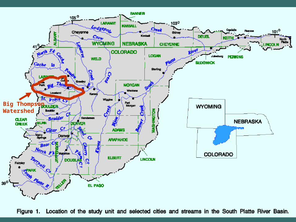
Big Thompson Watershed


Who is the Big Thompson Watershed Forum?
A group of water providers and other interested parties who are concerned about water quality in the Big Thompson Watershed.
The Forum’s mission is to assess and protect water quality in the Big Thompson Watershed.

Why is the BTWF interested in Water Quality?
Some reservoirs currently have elevated concentrations of nutrients and manganese.
Fish kills occur with some frequency.
Effects of forest fires on water quality.
Impacts from growth and development within the extended basin could further affect water quality.
Safe Drinking Water Act and Clean Water Act affect water providers and dischargers.

Increasing Need for Water-Quality Monitoring
Clean Water Action PlanSource Water ProtectionWatershed GroupsGrowth and DevelopmentConversion of Water Supplies from Agricultural to MunicipalIncreased Recreational Use

Past Water-Quality Monitoring Efforts
&V
$T$T
$T$T$T$T
$T$T$T$T$T$T$T
$T$T$T
$T$T
$T$T$T
$T
$T
$T$T
%U %U
%U %U
%U %U %U
%U%U
%U %U%U%U %U
'W'W
&V
&V&V&V&V
&V&V &V
&V&V &V
&V&V
&V
&V
#S
#S#S#S
#S
#S#S$T$T
$T
$T
%U %U
%U
%U %U
%U
%U
#S#S
#S
#S
#S
#S#S
#S
#S#S#S
#S#S#S#S
#S#S
#S #S#S#S#S
#S
#S
#S
#S
#S
#S
#S
&V City of Ft.Collins$T Ft. Collins, SWAT
%U USGS'W Upper Thompson SD
&V City of Greeley#S City of Loveland
$T NCWCD%U DWR#S Forum Sites

Past Water-Quality Monitoring EffortsVariability in sample collection, analytical methods, and data management.
Data were not shared among all parties.
Duplication of sampling was common.
Limited geographic scope of monitoring.

Current Status
Partners: BTWF, Ft. Collins, Greeley, Loveland, Tri-District Water Utility, BOR, NCWCD, CDWR, CSU.
Funding: Voluntary contributions from participants on a cost-shared basis.
Budget: $280,000 annually.

Current Status19 Professional Sites.22 Volunteer Sites.
Monthly / Bi-Monthly sampling.NWIS / In-house STORET data management.Password protected web-delivered data.

Future ActivitiesMerged Professional / Volunteer program.
Development of interactive data base/Web page.
Interpretation and analysis of water-quality data.
Reports on water-quality conditions and trends.
Coordinated monitoring with west slope portion of the basin.

Why did BTWF ask USGS to be involved?
USGS can work with the many partners involved with the effort.
USGS involvement lends increased credibility to data produced.
USGS already involved in monitoring in the watershed.
USGS can offer matching funds.

Why did BTWF ask USGS to be involved?
USGS has well recognized and documented sampling and analysis protocols.
USGS National Water-Quality Laboratory (NWQL) has highly regarded QA/QC procedures.
USGS NWQL has capability to run low-level nutrients.
USGS has capability to measure streamflow.

USGS Involvement – When? Where? How?
When and WhereAugust 2001Spring 2001
HowSampling and measurement.Low-level nutrient analysis.Data management and review.

Big Thompson
Big Thompson
Little Thompson
Buckhorn Creek
Sou
th P
latt
e
Estes Park
Fort Collins
Berthoud
M20
M10
M30
M40
North Fork
Loveland
M50 M60 M70
M80 M90
T10
M130 M150
C50
C20C30
C40
C120
C10
M10
T20 Tributary
Main Stem
Canal
Site Symbols
C10
15/yr
15/yr
Site Type
Sampling Frequency
15/yr BTWF Professional Monitoring Program
Watershed Boundary & Sampling Site Locations
Big Thompson
Watershed
M140
I-25
Pinewood Spgs
Johnstown
Drake
Milliken
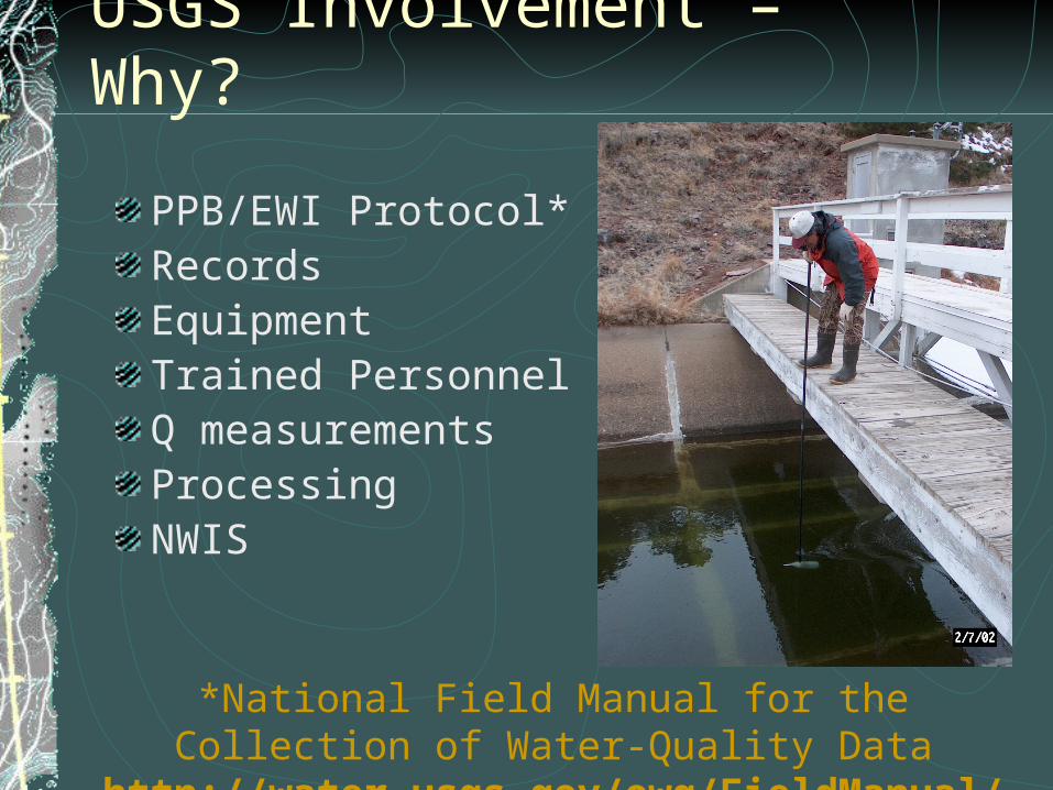
USGS Involvement – Why?
PPB/EWI Protocol*RecordsEquipmentTrained PersonnelQ measurementsProcessingNWIS
*National Field Manual for the Collection of Water-Quality Datahttp://water.usgs.gov/owq/FieldManual/

Sites and Sampling
Cross-sectionsSeasonsMixingLow/high flowsSafetyAccessBTWF objectives
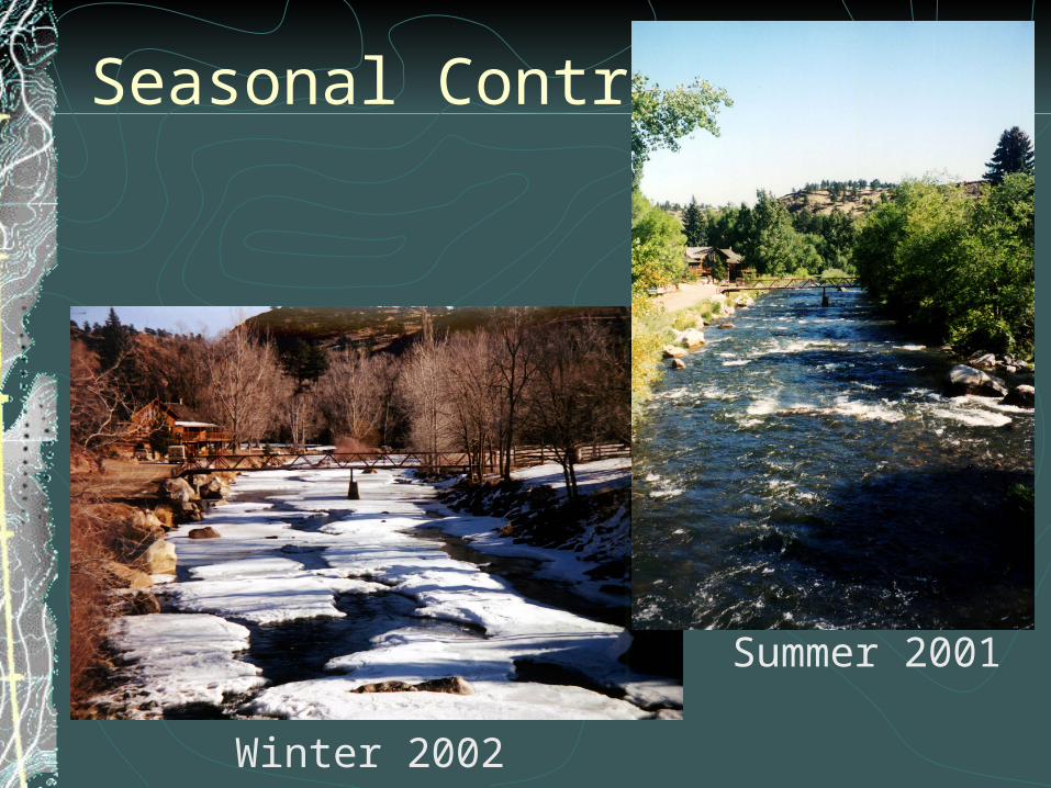
Seasonal Contrasts
Winter 2002
Summer 2001

Equipment Contrasts
Bridge board and AA Flow meter w/ 30 lb weight.
DH-81 sample wand and 1-L Teflon-nozzle sample bottle.

Challenges Overcome
Route & delivery logistics.Difficult field conditions.Multi-lab coordination.Data management.Overall program coordination.

Future Considerations…Monitoring program publication.
Stage-discharge ratings.
Expanded program.
Data analysis?
Turn-around times.
Coordination with other monitoring.

BTWF Professional and Volunteer Monitoring
Sampling Site Locations
Big Thompson
Big Thompson
Little Thompson
Buckhorn Creek
Sou
th P
latt
e
Estes Park
Fort Collins
Berthoud
M20
M10
M30
M40
North Fork
Loveland
M50M60
M110
M70
M80
M90
T10
M130
M140
C50
C20
C30
C40
C120
R40
C10
VT30
VT20
VT10
VT40
VM10VM20
VM30
VM40VM50
C10
M10
T10 Tributary
Main Stem
Canal
ReservoirR40
Site Symbols
15/year
15/year
18/year
Site TypeSampling Frequency
15/year
Volunteer 12/yearVT10
Milliken
I-25
Drake
Pinewood Spgs
M150
Watershed Boundary
Johnstown
Parting Thoughts...•Collaborative monitoring programs can work.
•Establishing a collaborative monitoring program has many challenges -- most of which can be overcome.
•Federal agencies play a critical role to ensure comparable, high quality data are collected in collaborative efforts.
•Successful collaborative professional-volunteer efforts could benefit from further study and recognition in peer-reviewed literature.


