83
Collect, Manage, Produce, Share Paul Hardy Estonia UC, Tallin, 2011
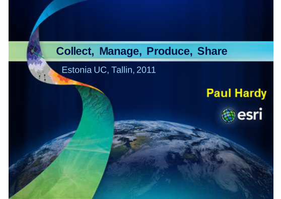
Collect, Manage, Produce, Share
Paul Hardy
Estonia UC, Tallin, 2011

We Live in a Rapidly Changing WorldIncreasingly Driven by Population Growth & Human Ac tion
Impacting
• Environment
• Society
• Economy
Challenging Sustainability . . . . . . For All of Us
2Esri Estonian UC 2011

Creating Unprecedented Issues
Climate ChangeClimate Change
PollutionPollution
Energy Energy
Natural Resources Natural Resources
FoodFood PovertyPoverty
SecuritySecurity
UrbanizationUrbanization
3Esri Estonian UC 2011

Our World Needs a New ApproachA Framework that Helps Us Understand Relationships and Patterns . . . . .
. . . And Lets Us Lets Us Chart a Better Future
Western Hemisphere
CO2 Emissions in the Atmosphere Population Density
Europe & Africa
4Esri Estonian UC 2011
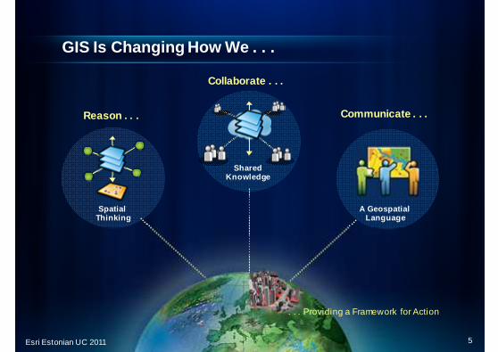
GIS Is Changing How We . . .
SpatialThinking
Reason . . .
SharedKnowledge
Collaborate . . .
Communicate . . .
A Geospatial Language
. . . Providing a Framework for Action
5Esri Estonian UC 2011

Environmental Change Monitoring
Polar Bear Tracking
Forest Changes
Kenya
Polar Ice Change
Ocean Monitoring
California
Performance Management
Chesapeake Bay
Sea Surface Temperature
Naval Oceanographic Office
Norway
Coal Mine Sludge
Germany
6Esri Estonian UC 2011

Natural Resource Management
Agriculture Production
United States
Carbon Accounting
Australia
Groundwater
California
Forest Carbon Management
Canada
Surficial Geology
Children’s Forest
United States
Petroleum ExplorationColumbia
ExplorationGeology
Northern Europe
Antarctica
Wetlands
United States
Geochemical Visualization
Alaska
7Esri Estonian UC 2011

Renewable Energy
Geothermal Resources
Solar Rooftop Model
Canada
Wind OffshoreSuitability
Solar Potential
Darmstadt, Germany
Renewable Energy Potential
South Korea
Renewable Energy Planning
Slope
Hawaii
Land Use
Hydro Power Potential
Mexico
Sun IntensityAnalysis - LIDAR
8Esri Estonian UC 2011

Planning for and Responding to Natural Disasters
Tsunami Modeling
South Asia
Sea Level Rise
New Hampshire
Volcanic Eruption
Eyjafjallajökull, Iceland
Earthquake
Haiti
Forest Fire History
California
Gulf of Mexico
Oil Spill
Dam Failure
Luzon, Philippines
Flooding
Nashville, Tennessee
Hurricane
Alabama
9Esri Estonian UC 2011

Land Administration
Multipurpose Cadastral System
Integrated Land Info Systems
Property Tax Assessment
Online Development Submissions
Online Auditor
Ohio
Parcel Notification
Ukraine
Houston, TX
Ireland
Hong KongBerkeley, CA
10Esri Estonian UC 2011

GIS Implementations Follow Common PatternsSupporting Enterprise and Pervasive Computing
All These Patterns Are Necessary. . . . . . To Enable SDI
Cloud / Web GISDesktop Serv er Federated
Individuals
• Ad Hoc Projects
• Analysis/Modeling
• Mapping
W orkgroups
• Shared Database
• Fixed Applications
• Transactions
Organizations
• Shared Services
• Integration
• Collaboration
New
Desktop Mobile Web
11Esri Estonian UC 2011

The ArcGIS System
Cloud
Enterprise
Local
Web
Mobile
Desktop
• Collect• Manage• Produce
• Share
Servers
12Esri Estonian UC 2011

SmartPhones
• iPhone / iPad• Windows• Android
Tablet
Mobile GIS is Growing RapidlyConnecting Mobile Workers, The Public . . . Everyon e
Supporting Citizen Engagement . . .. . . Providing Real-Time Situational Awareness
Photo Capture
ServerSituation Awareness
13Esri Estonian UC 2011

Cloud Computing
14Esri Estonian UC 2011

GIS is in the CloudProviding New Platform Flexibility
. . . Extending Existing Deployments
Miami
Recov ery.gov
Gulf
• Immediate Infrastructure
• Fast Deployment
• Scalability / Elasticity
Explorer
On-Premise
EnterpriseIntegration
Rich Clients Mobile
OpenStandards
Desktop
Cloud
15Esri Estonian UC 2011

Elastic Cloud Computing with AmazonEC2, ELB, EBS
Prebuilt AMIs
16Esri Estonian UC 2011
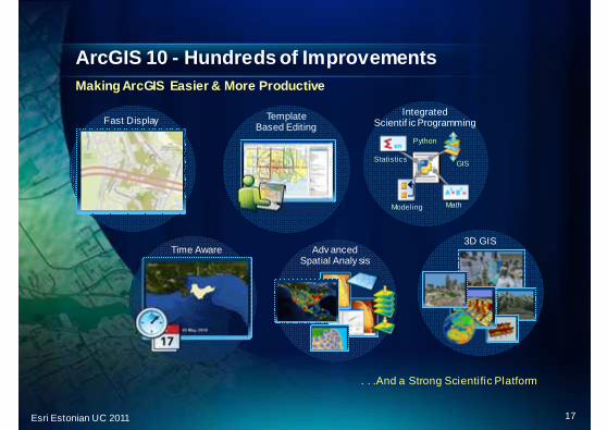
ArcGIS 10 - Hundreds of ImprovementsMaking ArcGIS Easier & More Productive
. . .And a Strong Scientific Platform
Adv anced Spatial Analy sis
Math
IntegratedScientif ic Programming
Python
GIS
Modeling
Statistics
3D GIS
Template Based Editing
Fast Display
Time Aware
17Esri Estonian UC 2011

GIS has become a Strong Scientific Platform
Time Aware
Advanced SpatialAnalysis
Math
IntegratedScientific Programming
Python
GIS
Modeling
Statistics
3D GIS
18Esri Estonian UC 2011

ArcGIS Has Integrated Dynamic Imagery ServicesHelping People See Issues Quickly
A Single Integrated Platform . . . . . . For Visualization, Analysis, Management and Di ssemination
On the FlyProcessing
Dynamic Mosaicking
Adv anced Processing and
Analysis
Imagery
Visualization
Fast Display
Analysis
Massiv ely Scalable
GIS
New Technologies
19Esri Estonian UC 2011

Many Forces Are Converging Enabling a Pervasive Geospatial Platform
. . . Opening Our World to Everyone
20Esri Estonian UC 2011

Collect, Manage, Produce, Share

Geodatabase
Collect once, use many timesMove away from linear, isolated, workflows
Maps/Charts Data Products Web Services
22Esri Estonian UC 2011
“The principle of collecting data once to the most appropriate quality and then reusing that data in all suitable contexts is fundamental to good data management and use.”

Transactional GIS WorkflowArcGIS System and the Geodatabase is at the heart
ArcGIS
Standards & Interoperability Job Tracking
Customer Requirements
Quality Control
23Esri Estonian UC 2011
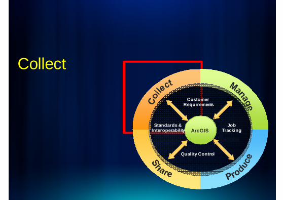
Collect
ArcGISStandards &
InteroperabilityJob
Tracking
Customer Requirements
Quality Control

Map/Text Docs
Vector/CAD Data
GeoImagery/Raster
Photogrammetry& LIDAR
GNSS & Field SurveyManage
ProduceShare
Collect
GIS
Mobile & Crowdsourced

Water Resources
Water Resources
TrafficTraffic
Population Census
Population Census
TweetTweet
Ozone LevelOzone LevelTemperatureTemperature Marine PollutionMarine
Pollution
Energy ConsumptionEnergy Consumption
Collect:Measuring everything, particularly anything that mo ves or changes
26Esri Estonian UC 2011

ConnectGeography is the connection between data layers
27Esri Estonian UC 2011

Crowd Sourcing and Social Media Are Being Integrate dProviding New Sources of Geospatial Information . . .
. . . Creating New Opportunities and Challenges
Situation Awareness
Analysis
Community Awareness
• SMS• E-mail• Twitter• Browser
Social Media
Volunteered Geographic Information (VGI)
Enriching GIS Systems withDiverse Observations,Perceptions and Opinions
Enriching GIS Systems withDiverse Observations,Perceptions and Opinions
28Esri Estonian UC 2011

OpenStreetMap VGIHaiti Port au Prince content in days following eart hquake
29Esri Estonian UC 2011

3D Data Collection
Elevation Imagery
Types of Data
Local Regional Global
Topographic (2 or 3D)
Subsurface
Models and Multipatches
Across Scales
Additional Features

Photogrammetry direct into ArcGIS (swisstopo)
31Esri Estonian UC 2011

Manage
ArcGISStandards &
InteroperabilityJob
Tracking
Customer Requirements
Quality Control
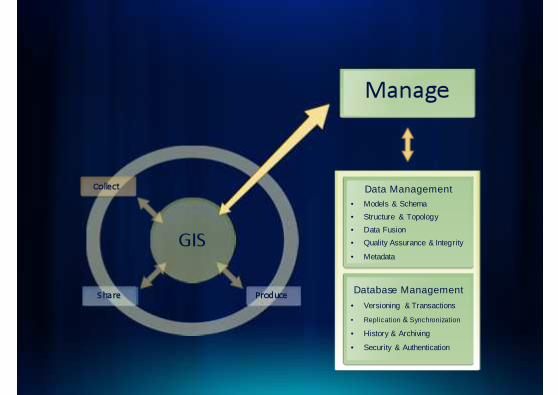
Manage
ProduceShare
Collect Data Management• Models & Schema
• Structure & Topology
• Data Fusion
• Quality Assurance & Integrity
• Metadata
Database Management
• Versioning & Transactions
• Replication & Synchronization
• History & Archiving
• Security & Authentication
GIS

Scaling up the databaseFrom MB, through GB, TB, to PB
34
Dimensions
Parcel Fabric
NetworksSurveys
Addresses
AnnotationVectors
3D Objects
Topology
CAD
Images
Terrain
Attribute
Cartography
Geodatabase
Scalable Data Management
Full GeoSpatial Data Model
File
Personal
Work Group
Enterprise
Esri Estonian UC 2011

Parcel Data ModelSpecifically for managing cadastral parcels
• Organizes lines and points into a connected parcel fabric
• Replaces Cadastral Fabric and Cadastral Editor of A rcGIS 9.x

Managing Distributed DataReplication of Geographic Information
Supports• Collaborating Agencies• Co-Data Producers• Central & Regional Offices• Mobile Units
OneWay
Two
WayRead /Write
ReadOnly Web Serv ices
Read /Write
• Change Only Updates• Synchronized Periodically• Works on the Web or Courier
National
Regional
Local
Hierarchy
Central
36Esri Estonian UC 2011

ArcGIS Workflow Manager
• Projects
• Products
• Data Quality
• Job Assignment/Tracking
• Staff and Contractors
37
Create job
Assign job
Define AOI
Create version
Edit version
Quality control
Reconcile &post version
Close job
Was JTX
Esri Estonian UC 2011

Produce
ArcGISStandards &
InteroperabilityJob
Tracking
Customer Requirements
Quality Control

Produce
Share
Collect Manage
Data Production• Editing
• Rule Based Validation
• Generalization
• Data Packaging
Cartographic Production• Design & Authoring
• Symbology & Representations
• Generalization
• Automated Text Placement
• Layout & Finishing
Analy sis and Reporting• Geographic Overlays
• Terrain
• Image & Raster
• Geostatistical
• Network
• Reports & Charting
Visualization and Modeling• 3D Visualization
• 4D Time Series
• Scientific Modeling
• Geoprocessing Models
GIS

Integrated Data for Analysis
• Geophysical and environmental• Census and Demographic• Business• Infrastructure• Surveying• Real time• Twitter and Facebook• Mobile• Many more…
Analysis:GIS is the hub of integration and analysis
40Esri Estonian UC 2011

GIS has increasing Cartographic capabilitiesNo longer need separate graphical finishing systems
41
PDF and prepress
WYSIWYG editing
Cartographic editing
Masking
Geometric Effects
Contour labeling
Text placement(Maplex)
Symbology rules
Automation ModelBuilder
ProductionMapping
Overrides forclarity
Esri Estonian UC 2011

42
• A richer way to symbolize data- Can convert existing symbology into representation rules- Then extend rules to get more control over symbolog y
• Rules held in the database- Invoke multiple layers of fills, strokes, and marke rs
• Overrides for exceptions- Graphic overrides – colour, width, angle, …- Geometry overrides – shape or position
Cartographic Representations

Maplex has given the publisher a powerful solution to a time-consuming and laborious process...text placement. Using Maplex, HarperCollins has automated this process and finds it is now ten times faster than before.
Images copyright 2008 HarperCollins Publishers
Maplex Labelling and Text Placement

New Generalization tools in ArcGIS 10Contextually aware
• New Tools Process Multiple Layers Contextually- Maintain patterns, density, & character of features
- Resolve conflicts between symbolized features at sc ale
- Support print & Web cartography workflows
441:9 000
1:18 000
Esri Estonian UC 2011

Thin Road Network toolReduce feature count
• Maintain pattern and density while retaining connectivity
45
1:18 000
1:36 000
Esri Estonian UC 2011

Resolve Building Conflicts toolSimplify building distribution
• Separate buildings from each other and from barrier s- Retain relative density and pattern
- Adjust visibility, size, and spacing to meet scale specification
461:9 000
1:18 000
Esri Estonian UC 2011
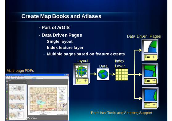
• Part of ArGIS
• Data Driven Pages- Single layout
- Index feature layer
- Multiple pages based on feature extents
Create Map Books and Atlases
Data Driven Pages
Layout IndexLayerData
End User Tools and Scripting Support47
Multi-page PDFs
Esri Estonian UC 2011

3D is a Key Aspect of Analysis and Visualization
Your Work Is Becoming Fundamentally 3D 48Esri Estonian UC 2011

Esri Mapping Solutions(was PLTS)
49Esri Estonian UC 2011
Includes• Tools• Templates• Data Models• Workflows• Cartography
For• Workflow Management• Mapping• QA/QC
Nautical Solution
Production MappingDefense Solution
Aeronautical Solution

Share
ArcGISStandards &
InteroperabilityJob
Tracking
Customer Requirements
Quality Control

Collect Manage
Produce
Share
Maps/Charts• Maps
• Charts
• Atlases
Data• Vector
• Imagery
• Raster (Grids, Terrains, Surfaces)
• Point Clouds
Serv ices• 2D Map & 3D Globe (WMS,KML)
• Feature (WFS)
• Image & Raster (WCS)
• Geoprocessing
Portals• SDI Catalog
• Services Portal
• E-Commerce
Metadata
GIS
51Esri Estonian UC 2011
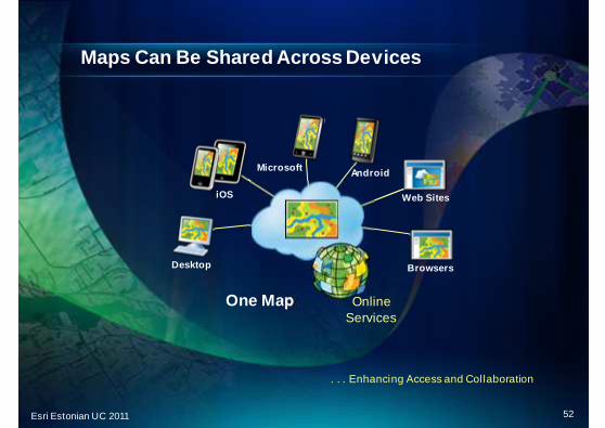
Maps Can Be Shared Across Devices
. . . Enhancing Access and Collaboration
One Map
Desktop
iOS
Microsoft Android
Web Sites
Browsers
OnlineServices
52Esri Estonian UC 2011

Environmental impact of Oil Spill
53Esri Estonian UC 2011

Japan Disaster Mapping
54Esri Estonian UC 2011

Social Media Mapping
55Esri Estonian UC 2011

Tsunami Mapping
56Esri Estonian UC 2011

Earth Shift Mapping
57Esri Estonian UC 2011
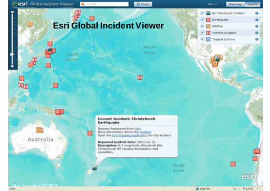
Esri Global Incident Viewer
58Esri Estonian UC 2011

Put the database at the center of the enterpriseFor efficient, versatile workflow
Manage
Map & DataProducts
Map ServicesField Edits &Crowd Sourcing
Produce
Collect Share
Sensors &Data
People &W orkflows
… Real Time Data Management
59Esri Estonian UC 2011

ArcGIS Online and ArcGIS.com

ArcGIS.com
• ArcGIS.com - the main interface to ArcGIS Online- Maps – Find, use, create, publish, share
- Apps – Web, mobile
- Tools - Geocoding
Discovery
Sharing
Mashups
Applications
Maps, Dataand Analysis
CommunitiesMultipleClients
61Esri Estonian UC 2011

Thousands of Ready-to-Use Maps and Services
Topographic
Imagery
Streets Socio-Economic Data
National Geographic
User Maps
Bing Maps
OpenStreetMap
(A-16 Lay ers)
Thematic
Bathymetry
(Coming)
Provided by Esri and …. . . Shared by Users
62Esri Estonian UC 2011
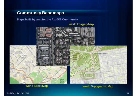
Community Basemaps
World Street Map
World Imagery Map
World Topographic Map
63Esri Estonian UC 2011

Community Topographic Basemap is GrowingCrowd Sourced Authoritative Content
• Template Based
• Collaborative
• Multi-Scale
• Authoritative Source
• Many Participants
A Free Community Service
64Esri Estonian UC 2011

Not one map, but many
• Multi-scale web mapping- Not just one map but 20 zoom levels of
increasing content, all consistent
- Compatible with Google and Bing Maps tiling scheme
65Esri Estonian UC 2011

Italy
World-wide coverage - small scales
San Diego
Hong Kong Canada66Esri Estonian UC 2011

World-wide coverage - medium scales
San Diego
Hong Kong
Rome
Canada67Esri Estonian UC 2011

World-wide coverage - large scales
San Diego
Hong Kong
Vatican, Rome
Canada68Esri Estonian UC 2011

New British content for Community Map
69Esri Estonian UC 2011

SDI & INSPIRE

SDI – Spatial Data InfrastructureCreating Common GIS Infrastructure To Support Multi ple Activities
. . . Improving Collaboration
. . . Providing Up to Date Information
• Land Use• Zoning
• Permits• Inspections• Addresses
• W ater And Sewers • Storm Drains • Streets
• W ater Resources
• Droughts• Pollution
• Crime Analysis• Public Safety
• Infrastructure• Public Safety• Hazardous
Materials
• Streets• Parcels• Utilities• Air Photos• Addresses• Topo
Public Access
• License• Owner Address• Utility Meters
Security
Public W orks
Environment
EmergencyMgmt.
Building
Planning
Business
71Esri Estonian UC 2011

What is INSPIRE?
• INSPIRE is an EC Directive- In force since 15 May 2007
- Process on-going
• Laying down general rules to establish an infrastructure for spatial information in Europe- “for the purposes of Community environmental policies and
policies or activities which may have an impact on the environment”
72Esri Estonian UC 2011

7373
INSPIRE Data (1)
• Whose data?
- Spatial data held by or on behalf of a public authority
• Which data?
- covering 34 spatial data themes laid down in 3 annexes
- “required to build environmental information systems”

7474
INSPIRE Data (2)
• Annex I
- Coordinate reference systems
- Geographical grid systems
- Geographical names
- Administrative units
- Addresses
- Cadastral parcels
- Transport networks
- Hydrography
- Protected sites
• Annex II
- Elevation
- Land cover
- Ortho-imagery
- Geology
• Annex III– Statistical units– Buildings– Soil– Land use– Human health and safety– Utility and governmental services– Environmental monitoring facilities– Production and industrial facilities– Agricultural and aquaculture facilities– Population distribution – demography– Area management/restriction/ regulation
zones & reporting units– Natural risk zones– Atmospheric conditions– Meteorological geographical features– Oceanographic geographical features– Sea regions– Bio-geographical regions– Habitats and biotopes– Species distribution– Energy Resources– Mineral resources

ArcGIS for INSPIRELeveraging ArcGIS to Provide an INSPIRE Solution
• Compliant Services
• Data Models
• Integrated Tools
• Extending ArcGIS Server(and Desktop)
ArcGIS
ArcGIS for INSPIRE
View
Discovery
Download
Enabling GIS Powered Solutions for INSPIRE Stakeholders
75Esri Estonian UC 2011

ArcGIS for INSPIRE Extends ArcGIS
Discov ery Serv ices, View Serv ices, Download Serv ice s, Metadata, Data Models
INSPIRE Geoportal Desktop GISWeb GIS Mobile GIS
- ESA- Eurostat- EEA- …
National & Regional Agencies EU Agencies
NLD
FGB
E
PI
…
View Services
Download Services
Discovery Services
MonitoringServices
76Esri Estonian UC 2011
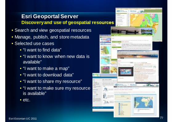
• Search and view geospatial resources
• Manage, publish, and store metadata• Selected use cases
• “I want to find data”• “I want to know when new data is
available”• “I want to make a map”• “I want to download data”• “I want to share my resource”
• “I want to make sure my resourceis available”
• etc.
Esri Geoportal ServerDiscovery and use of geospatial resources
77Esri Estonian UC 2011

Meet INSPIRE compliance in a timely manner
2010
2011
2019
78Esri Estonian UC 2011

Future?

ArcGIS9.3.1
Quality Improv ementPatch
ArcGIS Releases
Serv ice Pack 2(April/May)
ArcGIS 10
•Beta June 2011?
•Release Late 2011 or Early 2012
ArcGIS 10.1
Ongoing ReleasesWeb APIs, Explorer, Viewers, Online, Mobile (iOS, Android,Windows Phone & Mobile)
ArcGIS Next
80Esri Estonian UC 2011

3DBuffer
DynamicLegends iPhone
Generalization
HTML 5
W PF
Java
LIDARMosaic
Linux
Space-time clusters
10.1 Includes Many Projects
. . . Focused on User Needs
ArealKriging
3D CampusEditing W eb
Printing
Clustered Deployment
ImprovedKML
Geodesic Buffer
VisibilityVolume
DisconnectedMobile
Native 64-BitServers
MicrosoftAzure
KeyNumbering/
Labeling
W indowsPhone
Android
Content
DBMsTable Access
LightweightServer
Advanced Map
Automation
StatisticalHeatMaps
GDBAdminTools
ShadowVolume
Edit Tracking
Amazon W indows&Ubutu
ImageMensuration
LightweightRuntime
Performance
Net CDFImprovements
W ebThematic Mapping
81Esri Estonian UC 2011

Application of GIS – Limited only by our Imagination ?
A Collaborative Platform for Sustainable Development…..
Thousands
100’s of Thousands
Millions
Billions
ApplicationUsers
GIS Professionals
Research
Society
Sharing Our Indiv idual Knowledge…
82Esri Estonian UC 2011