TS13 State of the Art and Best Practice in SIM Chryssy Potsiou and Tassos Labropoulos TS13.3 Collection, Standardization, Visualization and Knowledge Sharing of Information about NSDI Activity in Various Countries FIG Working Week 2003 Paris, France, April 13-17, 2003 1/15 Collection, Standardization, Visualization and Knowledge Sharing of Information about NSDI Activity in Various Countries Chryssy POTSIOU and Tassos LABROPOULOS, Greece Key words: Spatial Information Management, State of the Art, National reports, Knowledge sharing, Web inventory. SUMMARY The field of interest of the FIG Commission 3 Working Group 3.3 is the monitoring of the development and the state of the art of Spatial Information Management (SIM) in participating countries. The objective of this paper is an analysis of the progress at national level and the establishment of a worldwide metadata inventory of “Best Practice” of institutional infrastructures and contents of data bases. The WG 3.3 Web Inventory major features so far include: - Contact information on WG members, contributors or international experts. - Schedule of WG 3.3 up to the year 2004. - National Reports collected since the year 1998, as well as related literature. - Useful global, regional and national SDI links. - Proposed structure for standardized country reports so that uniform, easy to analyze SIM information will be collected in the future. - References to recent workshops and proceedings and to future meetings and symposiums. - Information about future related inter-commission activity within FIG. So what’s new in the upgraded version of the Web Inventory? - National reports indexed by continent and accessed either through a traditional hypertext list of countries / continent or geographically through a graphical environment (i.e.: a world map, scalable to predefined steps) - A revised proposal for the standardization of the national reports together with a typical report as an example and an easy-to-fill form, in order to motivate and facilitate the participating delegates. - Research and invitation for co-operation with other SDI specialists to develop algorithms for quantification of descriptive data. The objective is to categorize and rank data in the descriptive fields of the Reports. - Geographic display of information contained in the National Reports, in a graphic environment, according to the field type of each field: Boolean, number (original or quantified), string or date, for better supervision and easier comparative analysis.
Transcript
TS13 State of the Art and Best Practice in SIM Chryssy Potsiou and Tassos Labropoulos TS13.3 Collection, Standardization, Visualization and Knowledge Sharing of Information about NSDI Activity in Various Countries FIG Working Week 2003 Paris, France, April 13-17, 2003
1/15
Collection, Standardization, Visualization and Knowledge Sharing of Information about NSDI Activity in Various Countries
Chryssy POTSIOU and Tassos LABROPOULOS, Greece
Key words: Spatial Information Management, State of the Art, National reports, Knowledge sharing, Web inventory. SUMMARY The field of interest of the FIG Commission 3 Working Group 3.3 is the monitoring of the development and the state of the art of Spatial Information Management (SIM) in participating countries. The objective of this paper is an analysis of the progress at national level and the establishment of a worldwide metadata inventory of “Best Practice” of institutional infrastructures and contents of data bases. The WG 3.3 Web Inventory major features so far include: - Contact information on WG members, contributors or international experts. - Schedule of WG 3.3 up to the year 2004. - National Reports collected since the year 1998, as well as related literature. - Useful global, regional and national SDI links. - Proposed structure for standardized country reports so that uniform, easy to analyze SIM
information will be collected in the future. - References to recent workshops and proceedings and to future meetings and symposiums. - Information about future related inter-commission activity within FIG. So what’s new in the upgraded version of the Web Inventory? - National reports indexed by continent and accessed either through a traditional hypertext
list of countries / continent or geographically through a graphical environment (i.e.: a world map, scalable to predefined steps)
- A revised proposal for the standardization of the national reports together with a typical report as an example and an easy-to-fill form, in order to motivate and facilitate the participating delegates.
- Research and invitation for co-operation with other SDI specialists to develop algorithms for quantification of descriptive data. The objective is to categorize and rank data in the descriptive fields of the Reports.
- Geographic display of information contained in the National Reports, in a graphic environment, according to the field type of each field: Boolean, number (original or quantified), string or date, for better supervision and easier comparative analysis.
TS13 State of the Art and Best Practice in SIM Chryssy Potsiou and Tassos Labropoulos TS13.3 Collection, Standardization, Visualization and Knowledge Sharing of Information about NSDI Activity in Various Countries FIG Working Week 2003 Paris, France, April 13-17, 2003
2/15
Collection, Standardization, Visualization and Knowledge Sharing of Information about NSDI Activity in Various Countries
Chryssy POTSIOU and Tassos LABROPOULOS, Greece
1. IDENTIFICATION OF THE NEED A great effort towards the establishment of National Spatial Data Infrastructures (NSDIs) has been made worldwide. The target for this is to eliminate fragmentation, gaps and duplication in data collection and to facilitate the availability, dissemination and appropriate use of spatial data. Spatial Information is now considered an important asset and should be managed appropriately. Much progress has been achieved in this field during the recent years, yet at different levels in various countries. The result is the existence of many kinds of legislation, structures and policies regulating the development and the flow of spatial data in various countries. In parallel, a major effort has also been made towards the creation of Regional Spatial Data Infrastructures (RSDIs), e.g. Europe, USA, etc. Usually structures within a region are as varied as the cultures, economies and politics in which they operate. The target for creating RSDIs is to harmonize formats, contents, conditions for access and measures within the countries of the same geographic and administrative region; to adopt more cost effective approaches and to develop better coordination mechanisms and common rules for building and handling the network of National Spatial Data Infrastructures which are under the responsibility of the “Member States” (INSPIRE 2002). Moreover, the activity towards establishing the Global Spatial Data Infrastructure as a response to the need for a common set of data layers at smaller scales such as transportation, hydrography, soils, land use, etc, to handle major global and regional commercial, political, environmental and humanitarian issues, has already made good progress (Potsiou et al 2001). Yet despite the progress achieved so far, at different levels of SDI activity, national-regional-global, many emerging issues remain to be faced; these issues are: organizational, strategic and institutional aspects, educational aspects, administrative and cultural concepts, coordination and cooperation between participating agencies towards multi-purpose data integration, reliability of products and services, access, privacy, national security, copyright, liability, ownership of data, pricing and cost recovery approaches. Although there have been a growing number of successes in NSDI implementation, there is also a considerable record of failures. In many cases the monopoly of the national public sectors as producers of spatial information to meet special requirements most frequently affects their pricing policies and thus reduces the possibilities of open and free access and multiple use of the collected data by other potential environmental users. There is a need for a customer-oriented approach. Individual national mapping agencies vary greatly in tasks for which each is made responsible, and the ability they have to customize their products to meet
TS13 State of the Art and Best Practice in SIM Chryssy Potsiou and Tassos Labropoulos TS13.3 Collection, Standardization, Visualization and Knowledge Sharing of Information about NSDI Activity in Various Countries FIG Working Week 2003 Paris, France, April 13-17, 2003
3/15
needs beyond those of their principal employers. The real needs of those most in need should drive the developments (Leonard 2000). Governments need help to understand what their societies require of SDI and to introduce changes of policy that will affect both users and suppliers. The application of intellectual property rights on spatial data and the limited degree of public access and commercialization of spatial information generated by the public sector are some of the main factors hindering the development of spatial data dissemination projects and the creation of NSDIs. Moreover, the costs for developing comprehensive National Spatial Data Infrastructures are high and usually the period needed for clear cost recoverability results is comparatively long. The need for developing mechanisms to facilitate experience and knowledge sharing in this field has been emphasized in many regional and international forums and conferences and some initiatives have already been taken. Under the same concept FIG Com3 WG3.3 is focusing on the monitoring of the development and the state of the art of Spatial Information Management (SIM) in participating countries (Potsiou 2002). For the better visualization and dissemination of the WG’s products it is proposed that it would be for the common benefit to establish a sophisticated Web-Inventory with all related information. The main purpose of this proposal is the experience and knowledge-sharing concerning “Good Practice” examples about progress in establishing National Spatial Data Infrastructures in all participating countries (Potsiou et al 2002). 2. OBJECTIVES, IMPACTS AND DESCRIPTION OF THE PROJECT The proposal for the creation of the “State of the Art in SIM” Web-Inventory has the following aims: - To increase cooperation between different jurisdictions, disciplines, professional groups,
public-private partnerships, public-public partnerships - To positively influence organizing and business models as well as procedures - To raise awareness and encourage participation regarding:
- institutional structures and Spatial Information Infrastructure - data availability and Spatial Data Infrastructure
- To work towards capacity building and transfer of experience mainly within FIG Com3, by providing information easily accessed, simply structured and annually updated
- To facilitate the development of NSDIs Based on cooperation both with WG 3.3 members and with other WGs, FIG Commissions and sister organizations, the project for the implementation of the proposed knowledge sharing Web-Inventory follows a step-wise approach. The following steps have already been accomplished: - The creation and maintenance of an up-to-date metadata base with information about the
State of the Art of SIM at national level and best practice examples on the managerial level. Recent information, collected through international meetings since the year 1998, about NSDI activity in twenty-two countries is included so far into the data-base
- Providing useful global, regional and national SDI links
TS13 State of the Art and Best Practice in SIM Chryssy Potsiou and Tassos Labropoulos TS13.3 Collection, Standardization, Visualization and Knowledge Sharing of Information about NSDI Activity in Various Countries FIG Working Week 2003 Paris, France, April 13-17, 2003
4/15
- Providing updated links with main relative organizations, projects, proceedings of workshops, relative literature, similar inventories, national delegates and international experts
- Providing information about the incoming activities and relative workshops and future action program of the project
Gradually, a research is made in analyzing the collected information and harmonizing data for better statistical analysis and visualization of information. As a next step, it has been decided to publish the collected information on the web site connected with the map. The benefits of such an approach are: - It allows the integration of various types of information - It provides better visualization of information - It provides a much more dynamic tool than a static text display - It improves and supports better analysis of information and facilitates the creation of new
information The web-site address is: http://www.fig.net/figtree/commission3/wgroups/WG_3/index.htm Some consideration and research is made towards providing GIS-structure data through the web site in the future. Web-enabled GIS lets the user deliver interactive query capabilities, such as searching for specific site locations, displaying and viewing multiple data sets and conducting queries for specialized analysis. The value of such a structure is: - Real-time integration of data, derived from multiple sources, from around the world - A common platform for this exchange - A cost-effective method for reaching a vast audience - Simplicity: everyone can use the web to access maps 3. NSDI SEARCH ENGINE
The first new component of the recently upgraded WG3.3 Web Inventory, is the NSDI archive section. The National Reports used to be alphabetically indexed according to the corresponding country and the user should browse the index to reach the NSDI report of his/her interest (Fig.1).
Fig.1: Alphabetical index of the National Reports
TS13 State of the Art and Best Practice in SIM Chryssy Potsiou and Tassos Labropoulos TS13.3 Collection, Standardization, Visualization and Knowledge Sharing of Information about NSDI Activity in Various Countries FIG Working Week 2003 Paris, France, April 13-17, 2003
5/15
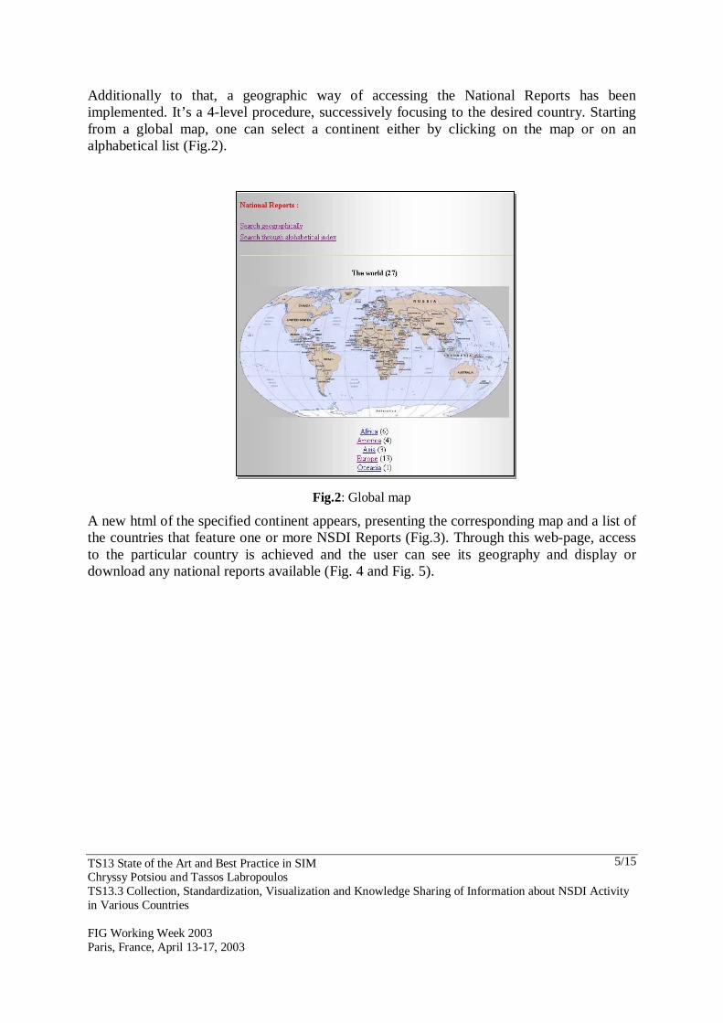
Additionally to that, a geographic way of accessing the National Reports has been implemented. It’s a 4-level procedure, successively focusing to the desired country. Starting from a global map, one can select a continent either by clicking on the map or on an alphabetical list (Fig.2).
Fig.2: Global map
A new html of the specified continent appears, presenting the corresponding map and a list of the countries that feature one or more NSDI Reports (Fig.3). Through this web-page, access to the particular country is achieved and the user can see its geography and display or download any national reports available (Fig. 4 and Fig. 5).
TS13 State of the Art and Best Practice in SIM Chryssy Potsiou and Tassos Labropoulos TS13.3 Collection, Standardization, Visualization and Knowledge Sharing of Information about NSDI Activity in Various Countries FIG Working Week 2003 Paris, France, April 13-17, 2003
6/15
Fig.4: Map & NSDI of Greece
Fig.3: Map of Europe
Fig.5: Hellenic SDI Report
4. STANDARDIZATION OF NATIONAL REPORTS In order to optimize the use of National Reports, a proposal (Potsiou et al 2002) was presented about how standardized national reports might be carried out in the future. A revised structure of nine sections is suggested, each having a different theme: - Section 1: General information-statistical indicators - Section 2: Short description of the state of the art in NSDI - Section 3: Legal Framework - Section 4: Basic characteristics of organizations/agencies - Section 5: Technical aspects of the data sharing system
TS13 State of the Art and Best Practice in SIM Chryssy Potsiou and Tassos Labropoulos TS13.3 Collection, Standardization, Visualization and Knowledge Sharing of Information about NSDI Activity in Various Countries FIG Working Week 2003 Paris, France, April 13-17, 2003
7/15
- Section 6: Pricing policy-financial issues - Section 7: Future plans/strategies & research - Section 8: International activity - Section 9: Identity data of the author The full form for the standardized reports is available on the web site together with more explanation about the expected content for each section. The initial completion of all sections of the suggested form, is of great value for the further development of the web inventory and for the dissemination of information. We request all countries to fill out this form regardless of whether they have submitted data previously on a fully textual national report. The information included in the standardized form will be used for further analysis and visualization of similar information; the textual national report will provide with more detailed information and will focus on issues of particular importance according to the specific country and the experience of the author. Once delivered at future annual meetings only an update of the standardized form will be asked annually so that users will be provided with all current trends and developments. In addition, the standardized National Report of Greece is given in the Appendix as an example to show how the form should be completed. The web inventory will have a modular structure so that delegates will be able to add new information incrementally. A similar effort has recently been started through a “State of the Art” WG belonging to the INSPIRE activities. Its aim is to collect similar information about the European countries. To date there is little information collected but the target of the present project will be the harmonization of both efforts and activities, as far as this is possible, for achieving better results. 5. GEOGRAPHIC DISPLAY OF QUANTITY INFORMATION “A picture is worth a thousand words”. It’s true. Imagine how instantly and deeply one could understand the overall status of SDI in each country of a continent, or in each continent on a world map. This is almost impossible at this time considering the majority of descriptive data a National Report contains. Thus, a need arises to find a way to convert descriptive information into indicators expressing either the level of each National Report field or it’s “yes/no” condition. The table below presents some of the fields of the “Uniformed” National Reports that can be “numerized”. The three major field categories that we come across are the following: - Fields that are already in a numeric format (i.e: Area & Population) - Fields, which are descriptive text, is corresponded to a 1-5 level. For example in SDI
specialists education: − “1” is equivalent to “not existing” − “2” is equivalent to “basic education”
TS13 State of the Art and Best Practice in SIM Chryssy Potsiou and Tassos Labropoulos TS13.3 Collection, Standardization, Visualization and Knowledge Sharing of Information about NSDI Activity in Various Countries FIG Working Week 2003 Paris, France, April 13-17, 2003
8/15
− “3” is equivalent to “mid-level education” − “4” is equivalent to “high-level education” − “5” is equivalent to “very specialized education”, and
- Fields that can be covered with a yes/no answer. For example ‘Legislation on SIM’, either exists or not in a country.
Field Type Width Definition Area N 10 Country area Population N 10 Country population Education N 1 Level of education of SDI specialists (1-5) Internet Access (%)
N 2 Internet access of local population
Publications N 3 Number of National SIM publications
Necessity B 1 Is NSDI necessary for sustainable Land Administration? (y/n)
Agency B 1 Is there a responsible Agency for NSDI implementation? (y/n)
Policy B 1 Does an established policy on SIM development exist? (y/n)
Laws B 1 Does legislation on SIM exist? (y/n) Associations N 2 Existence of National GIS/SIM associations Infrastructure N 1 Level of SIM infrastructure (1-5)
Availability N 1 Level of availability of SIM data on the Internet (1-5)
International B 1 Co-operations, support, international project exist? (y/n)
This way, any type of information provided can be visualized. An example is given in Fig. 6, where the Continent of Europe is presented differentiated on whether a Country’s National Report exists on the WG3.3 Web-Site or not.
TS13 State of the Art and Best Practice in SIM Chryssy Potsiou and Tassos Labropoulos TS13.3 Collection, Standardization, Visualization and Knowledge Sharing of Information about NSDI Activity in Various Countries FIG Working Week 2003 Paris, France, April 13-17, 2003
9/15
Fig.6: Map of Europe showing the coverage achieved so far with collected National reports 6. CONCLUSIONS The FIG Com3 interest in the “State of the Art of SIM” is now supported by a useful tool which enables easy access to the collected information. It is up to the interest of all individual delegates to contribute more information according to their great experience in the field of implementing NSDIs. The more the input of information, the better research and experience and knowledge sharing it will bring. New technological developments like GIS structure of the data through the web site will be the challenge for the future.
TS13 State of the Art and Best Practice in SIM Chryssy Potsiou and Tassos Labropoulos TS13.3 Collection, Standardization, Visualization and Knowledge Sharing of Information about NSDI Activity in Various Countries FIG Working Week 2003 Paris, France, April 13-17, 2003
10/15
REFERENCES Coleman D. J., McLaughlin J., 1997. Defining Global Geospatial Data Infrastructure
(GGDI): Components, Stakeholders and Interfaces, Department of Geodesy and Geomatics Engineering, University of New Brunswick, Fredericton N.B., Canada, http://eurogi.org/gsdi/ggdiwp1.html
INSPIRE, 2002. Preliminary Assessment Statement, Proceedings of INSPIRE (Infrastructure
for Spatial Information in Europe) Expert Group Meeting, 30-31 Oct. 2002, Athens, Greece.
Leonard J., 2000. Europe’s Official Mappers-Quo Vadis?, Proceedings of the FIG Working
Week (in CD), Prague. Potsiou C., 2001. National Report: Existing Activity in Geoinformatics and the Need for
establishing a NSDI in Greece, http://www.fig.net/figtree/com3 Potsiou C., Volakakis M., Doublidis P., 2001. Hellenic Cadastre: State of the Art,
Experience, Proposals and Future Strategies. Computers, Environment and Urban Systems, vol. 25 (2001), pp. 445-476.
Potsiou C., 2002. Spatial Information Management: Knowledge, Organizations and Tools,
Proceedings of the XXII FIG International Congress (in CD), Washington D.C., USA. Potsiou C., Labropoulos T., 2002. Spatial Information Management State of the Art -
Developing the FIG Com3 WG3.3 Web-Inventory, Proceedings of the FIG Com3 Annual Meeting and Symposium on GIS (in CD), Istanbul, Turkey, http://www.fig.net/figtree/com_3_istanbul/index.htm
BIOGRAPHICAL NOTES Chryssy Potsiou Dr. Surveying Engineer, Special Teaching and Research Scientist, Lab. of Photogrammetry, School of Rural and Surveying Engineering, National Technical University of Athens (NTUA), Greece. Graduated from NTUA in 1982, Phd in the field of Spatial Cadastral Information collection and management: ‘Digital Spatial Data for the Hellenic Cadastre’, from NTUA, in 1995. Since 1982, she works as Private Surveying Engineer - consultant, mainly in Photogrammetry and Urban Planning studies. Since 1986, she works at the Lab. of Photogrammetry of NTUA, teaching Photogrammetry, Cadastre and Cartography and participating in research programs. Her research activity focuses on the fields of Cadastre, Land Administration, SIM, terrestrial and digital Photogrammetry. Since 1982 she participated in many FIG (Com7 and Com3), CIPA and ISPRS meetings presenting her work. 1992-96 and 1996-2000 elected member of the Bureau and Treasurer of the Hellenic Society for Photogrammetry and Remote Sensing.
TS13 State of the Art and Best Practice in SIM Chryssy Potsiou and Tassos Labropoulos TS13.3 Collection, Standardization, Visualization and Knowledge Sharing of Information about NSDI Activity in Various Countries FIG Working Week 2003 Paris, France, April 13-17, 2003
11/15
1994-97 she worked for CIPA Bureau (International Society for Architectural Photogrammetry), as secretary to the President. 1998-2001 Technical consultant at Ktimatilogio SA (Hellenic Cadastre) Since 1998 she participates in UN-ECE WPLA and CERCO meetings 1998-2001 chair of WG3.1 of FIG Com3 (organized the Athens 2000 Com3 annual meeting) Since 1999 national delegate of the Technical Chamber of Greece in FIG general assembly 2001-2003 elected member of the Bureau UN-ECE WPLA 2001-2004 Vice-chair of FIG Com3, chair of WG3.3 of Com3 2002-2004 elected member of the Bureau of the Hellenic Society for GIS 2003-2004 Secretary General of the Organizing Committee for the FIG WW2004 She speaks: Greek, English and German. She has organized national and international meetings and seminars in Greece. Tassos Labropoulos Surveying Engineer. He graduated from the National Technical University of Athens, Greece, in 1997 and is now a Ph.D. Student in the field of “Land Valuation & Information Systems”. He has a 6-year field & office working experience in the private sector, as well as educational experience through lectures, seminars & field practice at the University. Also he has participated in research projects and has many publications in international & Hellenic conference proceedings and scientific magazines. CONTACTS Dr Chryssy Potsiou Special Research & Teaching Scientist, School of Rural and Surveying Engineering, Lab. of Photogrammetry, National Technical University of Athens 9 Iroon Polytechniou St. 157 80 Athens GREECE Tel. +30 210 7722686 Fax +30 210 7722677 Email: [email protected] Tassos Labropoulos School of Rural and Surveying Engineering, Lab. of Photogrammetry, National Technical University of Athens 9 Iroon Polytechniou St. 157 80 Athens GREECE Tel. +30 210 7722652 Fax +30 210 7722677 Email: [email protected]
TS13 State of the Art and Best Practice in SIM Chryssy Potsiou and Tassos Labropoulos TS13.3 Collection, Standardization, Visualization and Knowledge Sharing of Information about NSDI Activity in Various Countries FIG Working Week 2003 Paris, France, April 13-17, 2003
12/15
APPENDIX
Standardized Report Country: GREECE
Section 1: General information - Basic statistical indicators • Country area, population
13.2 Mhectares, 10,500,000 inhabitants
• Brief description about education in geoinformatics (post graduation courses - on going training in SIM - number of GeoInfo specialists/year – number of Universities – level of education in SIM/GIS)
National Technical University of Athens: Geoinformatics postgraduate course, 1 year duration, 20 students per year Aristotle University of Thessaloniki: Postgraduate course of Surveying School, 1.5 year Technical Chamber of Greece: ongoing seminars in GIS Ministry of Labour: ongoing seminars in GIS
• The role of Surveyor in SIM
Since 1990, a large number of Surveying engineers are involved in GIS and SIM activity
• Percentage of Internet access of the local population and increasing rate
Internet access 9% of the population
• Main publications in the field of SIM (magazines, conference proceedings)
- Section 2: Short description of the state of the art in NSDI -vision • Has the government so far reached the consensus that NSDI is necessary for
sustainable Land Administration?
Yes, The “Information Society” public agency has already established a committee to work on that issue
• Does a working system for SD exchange at national/ local/ or experimental level already exist at your country? Is there a responsible agency/ organisation?
No, a working system does not exist. Neither is there a responsible agency established especially for that. The Hellenic Mapping and Cadastre Organization (HEMCO) is by Law the official NMA of the country. The Hellenic Military Geographical Service (HMGS) has done the most cartographic activity for a hundred and thirteen years.
• Is there a National SIM policy (access, pricing, privacy, liability, copyright) already developed?
TS13 State of the Art and Best Practice in SIM Chryssy Potsiou and Tassos Labropoulos TS13.3 Collection, Standardization, Visualization and Knowledge Sharing of Information about NSDI Activity in Various Countries FIG Working Week 2003 Paris, France, April 13-17, 2003
13/15
At HEMCO and HMGS there is a traditional pricing policy, access - restrictions and copyright regulations for the map series and airphotos that are commercialised
• Description of existing problems, barriers (i.e. lack of infrastructure, education, funds, coordination, legal framework)
Lack of appropriate legal framework, lack of awareness and strong political will
Section 3: Legal Framework for NSDI
• Political support, brief description of existing legislation for the establishment of a responsible agency/ operational regulation/ strategy
Some political support started since the year 2000, were a relevant proposal was prepared by the management of HEMCO
• Protection of databases, copyright, Internet services
No such information available
• Existing Legislation relevant to Spatial Data
The regulations that protect and rule both the collection and use of data (restrictions) and the operation of the responsible for that agencies like: HEMCO, HMGS, and Ministries dealing with collection and dissemination of spatial data .
Section 4: Basic info about NSDI organisations/agencies/associations
• Web address, organisational plan, human resources, data providers/ users
www.okxe.gr, www.ktimatologio.gr, nfp-gr.eionet.eu.int, www.minenv.gr/ Such information is available at the individual web-sites
• Main agencies responsible for spatial data production and main projects under development
Hellenic Ministry of Environment, Physical Planning and Public Works - Hellenic Mapping and Cadastre Organization (HEMCO) and other divisions Hellenic Ministry of Agriculture Hellenic Ministry for the Development - Institute of Geology and Mineral Exploration Hellenic Ministry of National Economy – National Statistical Service of Greece Hellenic Ministry of Defense – Hellenic Military Geographical Service (HMGS) and Hydrgraphic Service Details about the running projects are mentioned at the extended national report
TS13 State of the Art and Best Practice in SIM Chryssy Potsiou and Tassos Labropoulos TS13.3 Collection, Standardization, Visualization and Knowledge Sharing of Information about NSDI Activity in Various Countries FIG Working Week 2003 Paris, France, April 13-17, 2003
14/15
Section 5: Technical aspects of the data sharing system
• Brief description of the structure, software/hardware, data modelling, standards/
technical specifications, metadata, compilation time, updating frequency, data capturing/updating methods, quality control
--
• Map series included in NSDI (scales & coverage)
There is plenty of digital spatial information at various scales, available in various agencies but there is no data sharing system for the metadata and the facilitation of data dissemination
• Types of products, value-added products / services, if existing
--
• Clearinghouses, delivery mechanisms
--
• Accessibility
--
• Internet (data / services)
-- Section 6: Pricing policy - financial issues
• Partnerships – privatisation - customers
Some pilot mapping work is commissioned to the Private Sector as it is with the Cadastral Surveys
• Price of data - services
Comparatively low prices of mapping data and airphotos. Not many services are provided
• Profit - self recoverability
No such information available Section 7: Future plans/strategies & research activity within the agency
There is available information (it is included in the extended national report) about: - the Information Society Committee
TS13 State of the Art and Best Practice in SIM Chryssy Potsiou and Tassos Labropoulos TS13.3 Collection, Standardization, Visualization and Knowledge Sharing of Information about NSDI Activity in Various Countries FIG Working Week 2003 Paris, France, April 13-17, 2003
15/15
- the Hellenic Cadastre Project Section 8: International co-operation, participation to international or