20
COLOMBIA GOLD SYMPOSIUM November 2017 QUEBRADONA EXPLORATION PROJECT Pablo Noriega – Geology Manager

COLOMBIA GOLD SYMPOSIUM
November 2017
QUEBRADONA EXPLORATION PROJECT
Pablo Noriega – Geology Manager

PROJECT SUMMARYPROJECT SUMMARYPROJECT SUMMARYPROJECT SUMMARYOwnership:
� AngloGold Ashanti (93.45%)
� B2Gold (6.55%)
Location:
� Middle Cauca Region, 110 Km
south of Medellin
Deposit Type:
� Porphyry Cu – Au.
Commodities:
� Copper, Gold, Silver, Molybdenum
Status:
� Actually in PFS phase.
Most probable Mining Method:
� Underground caving.
Most probable process:
� Flotation.
Medellín
Bogotá
Gramalote
La Colosa
Quebradona
Other AngloGold Ashanti projects
City
Colombia
Cali
Quebradona

LOCATIONLOCATIONLOCATIONLOCATIONMiddle Cauca region of Colombia near the town of Jericó, in the Department of
Antioquia, 110 km south of Medellín. The town of Jericó which houses c.7,500
residents is located 7 km from the project area. Religious and cultural center,
strong historical and agricultural (coffee).
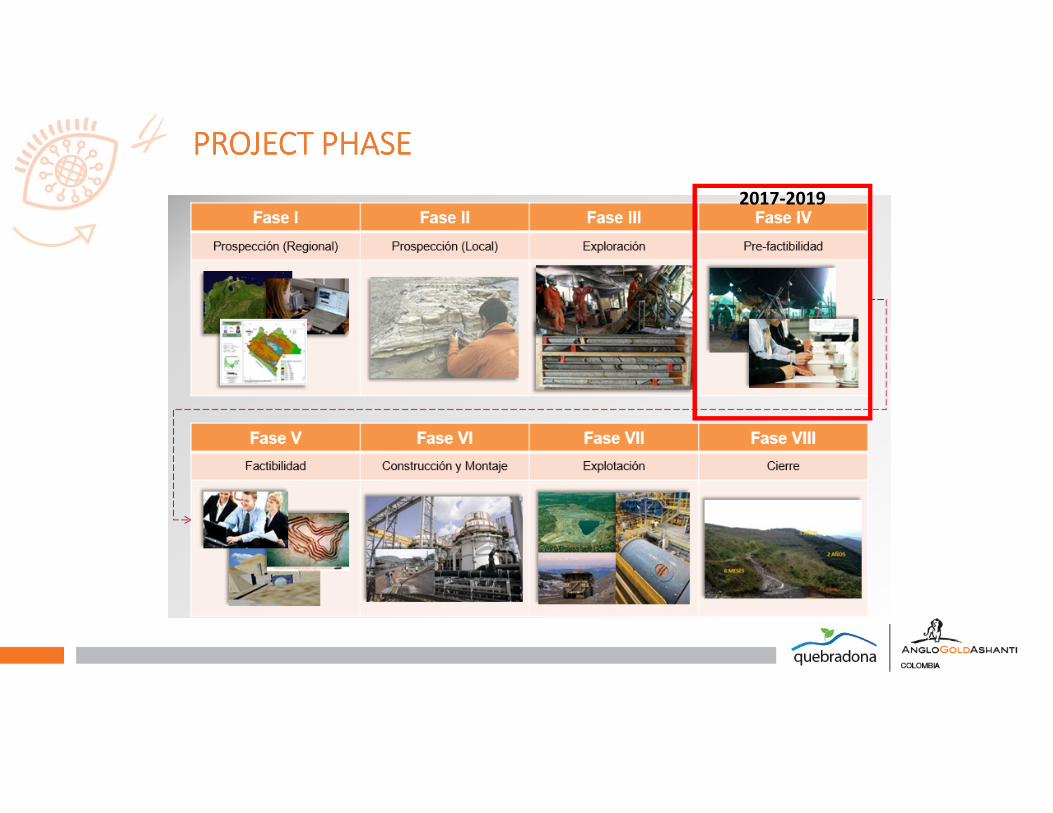
2017-2019
PROJECT PROJECT PROJECT PROJECT PHASEPHASEPHASEPHASE
DISCOVERY HISTORYDISCOVERY HISTORYDISCOVERY HISTORYDISCOVERY HISTORY
� 2004 Regional exploration AGA.
� 2006/2007 Gold targets definition (B2 Gold).
� 2008/2009 Drilling B2 Gold.
� 2010 AGA resume operational control.
� 2011 Nuevo Chaquiro Discovery drill hole. (Nuevo Chaquiro is a target in Quebradona Project)
� 2013 CHA-039 drill hole in medium grade zone.
� 2014 CHA-048 High grade zone definition.
� 2014 Resource Statement – actually about 90 Km drilling (617 Mt @ 0.63 % Cu – 0.31 g/t Au – 4.27 g/t
Ag – 128 g/t Mo) – 100 % basis.
� 2015 � 2017 Estimation update. Geology-hydrogeology, geotechnical, metallurgical &
geometallurgical work.

DISCOVERY HISTORYDISCOVERY HISTORYDISCOVERY HISTORYDISCOVERY HISTORY
�Stream sediment � Modest gold and copper anomalies localized in Chaquiro Area.
�Follow up and face to face with stockwork outcrop.
Original picture from 2015 by Timoleón Garzón.
NE SW
Low grade limit
High grade limit
Discovery Outcrop

DISCOVERY HISTORYDISCOVERY HISTORYDISCOVERY HISTORYDISCOVERY HISTORY
2006 – 2008 Status2005 Discovery outcrop
�Soil and rock sampling, mapping and initial drill testing. Later Geophysics.
�Started from the obvious. From Chaquiro to Nuevo Chaquiro.
�Key: First mover advantage, multiple technical approach, perseverance, management involvement and support.

REGIONAL REGIONAL REGIONAL REGIONAL GEOLOGY GEOLOGY GEOLOGY GEOLOGY NUEVO CHAQUIRO REGIONAL SETTING
�Pull–apart basin situated between two major regional
N-S fault systems
�Basin filled with andesitic volcaniclastics, tuffs, and
flows (Combia Formation)
�Toward end of Combia volcanism, there were a series
of diorite and quartz diorite intrusions –many
mineralized (porphyry Au, Cu, Mo and porphyry
related ISS veins)
�Mid-Cauca Belt : at least 9 districts/deposits known
�Age of Combia Formation: 6-11 Ma
�Age of Miocene Intrusives: 7- 8.5 Ma
�Age of Nuevo Chaquiro: 7.47 +/- 0.1 Ma
Map Source: Modified from Gonzalez H, 2001. Ingeominas.
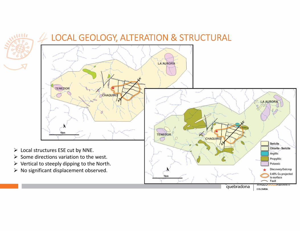
LOCAL GEOLOGY, ALTERATION & STRUCTURALLOCAL GEOLOGY, ALTERATION & STRUCTURALLOCAL GEOLOGY, ALTERATION & STRUCTURALLOCAL GEOLOGY, ALTERATION & STRUCTURAL
� Local structures ESE cut by NNE.
� Some directions variation to the west.
� Vertical to steeply dipping to the North.
� No significant displacement observed.
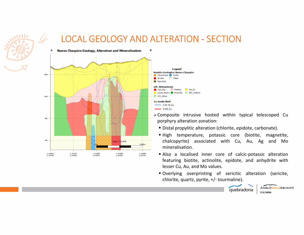
LOCAL LOCAL LOCAL LOCAL GEOLOGY AND ALTERATION GEOLOGY AND ALTERATION GEOLOGY AND ALTERATION GEOLOGY AND ALTERATION ---- SECTION SECTION SECTION SECTION
�Composite intrusive hosted within typical telescoped Cu
porphyry alteration zonation:
� Distal propylitic alteration (chlorite, epidote, carbonate).
� High temperature, potassic core (biotite, magnetite,
chalcopyrite) associated with Cu, Au, Ag and Mo
mineralisation.
� Also a localised inner core of calcic-potassic alteration
featuring biotite, actinolite, epidote, and anhydrite with
lesser Cu, Au, and Mo values.
� Overlying overprinting of sericitic alteration (sericite,
chlorite, quartz, pyrite, +/- tourmaline).
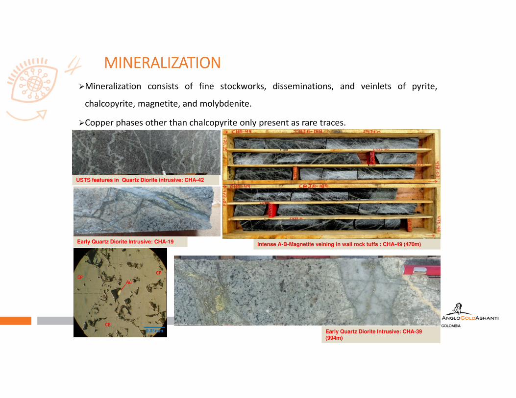
MINERALIZATIONMINERALIZATIONMINERALIZATIONMINERALIZATION
USTS features in Quartz Diorite intrusive: CHA-42
Early Quartz Diorite Intrusive: CHA-39 (994m)
Intense A-B-Magnetite veining in wall rock tuffs : CHA-49 (470m)Early Quartz Diorite Intrusive: CHA-19
�Mineralization consists of fine stockworks, disseminations, and veinlets of pyrite,
chalcopyrite, magnetite, and molybdenite.
�Copper phases other than chalcopyrite only present as rare traces.
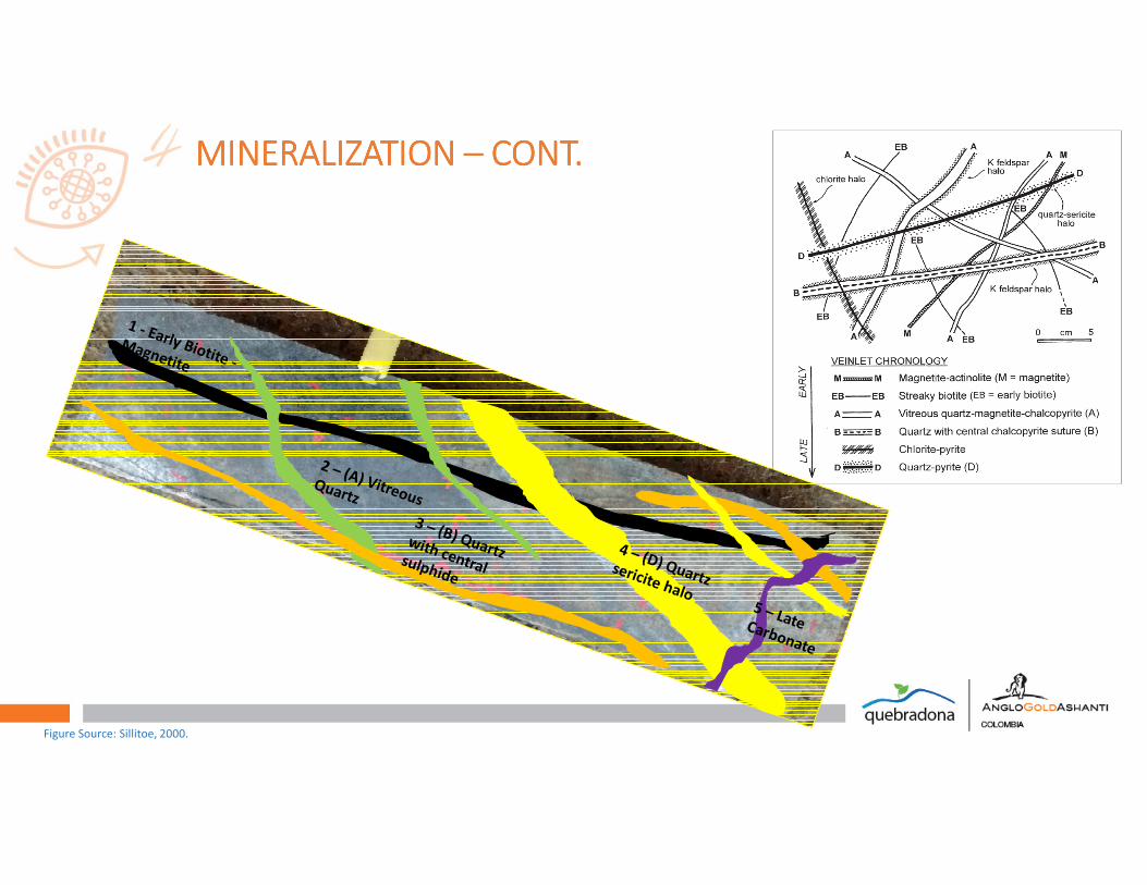
MINERALIZATION MINERALIZATION MINERALIZATION MINERALIZATION –––– CONT.CONT.CONT.CONT.
Figure Source: Sillitoe, 2000.
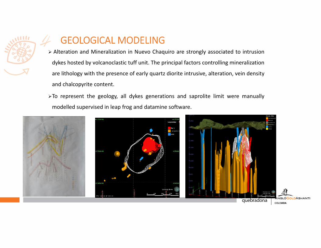
GEOLOGICAL GEOLOGICAL GEOLOGICAL GEOLOGICAL MODELINGMODELINGMODELINGMODELING� Alteration and Mineralization in Nuevo Chaquiro are strongly associated to intrusion
dykes hosted by volcanoclastic tuff unit. The principal factors controlling mineralization
are lithology with the presence of early quartz diorite intrusive, alteration, vein density
and chalcopyrite content.
�To represent the geology, all dykes generations and saprolite limit were manually
modelled supervised in leap frog and datamine software.

GRADE GRADE GRADE GRADE MODELINGMODELINGMODELINGMODELING
�Separate set of volume were manually generated in datamine software for: 0.6 % CU,
0.45 % CU, >100 ppm Mo, 6 % S and 3 % S.
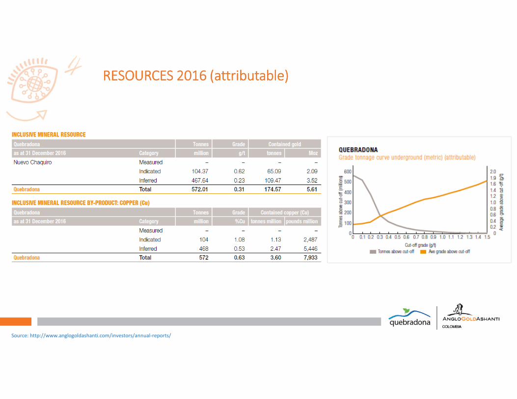
RESOURCES 2016 (attributable)RESOURCES 2016 (attributable)RESOURCES 2016 (attributable)RESOURCES 2016 (attributable)
Source: http://www.anglogoldashanti.com/investors/annual-reports/
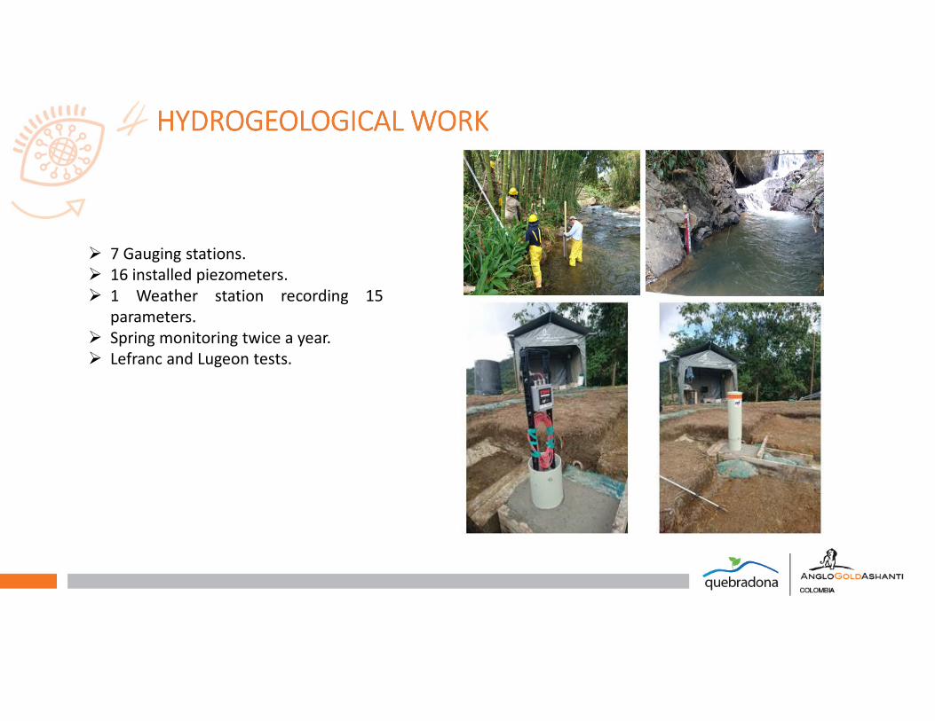
� 7 Gauging stations.
� 16 installed piezometers.
� 1 Weather station recording 15
parameters.
� Spring monitoring twice a year.
� Lefranc and Lugeon tests.
HYDROGEOLOGICAL HYDROGEOLOGICAL HYDROGEOLOGICAL HYDROGEOLOGICAL WORK WORK WORK WORK
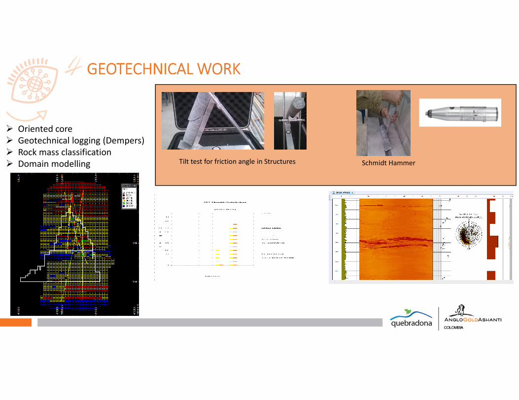
� Oriented core
� Geotechnical logging (Dempers)
� Rock mass classification
� Domain modelling
GEOTECHNICAL GEOTECHNICAL GEOTECHNICAL GEOTECHNICAL WORK WORK WORK WORK
Tilt test for friction angle in Structures Schmidt Hammer

DRILLING PROCESS AND RECOVERYDRILLING PROCESS AND RECOVERYDRILLING PROCESS AND RECOVERYDRILLING PROCESS AND RECOVERY
PROJECT HIGHLIGHTPROJECT HIGHLIGHTPROJECT HIGHLIGHTPROJECT HIGHLIGHT
�Options to place project layout in and off mountain.
�Highly competitive clean concentrate.
�No issues with Artisanal miners.
�Changing social & political scenarios.
�Endowment to explore.
THANKS THANKS THANKS THANKS ---- GRACIASGRACIASGRACIASGRACIAS


