Colorado Plateau Coring Project (CPCP) Workshop 2007 Field Trip November 15, 2007 FIELD TRIP LEADERS 1 Andrew R. C. Milner, 2 James I. Kirkland, and 1 Sarah Z. Spears 1 St. George Dinosaur Discovery Site at Johnson Farm 2 Utah Geological Survey Early Jurassic outcrops in Warner Valley, Washington County, Utah. From bottom to top: Dinosaur Canyon (red-brown ledges in foreground) and Whitmore Point (purplish, gray, and green slopes) members, Moenave Formation; Springdale Member of Kayenta Formation (yellowish sandstone at base and remainder of resistant ledge); and "silty facies" and "transition zone" of Kayenta Formation into the lower part of the Navajo Sandstone. Photo by Sarah Z. Spears.
Transcript
Colorado Plateau Coring Project (CPCP)
Workshop 2007
Field Trip November 15, 2007
FIELD TRIP LEADERS 1Andrew R. C. Milner, 2James I. Kirkland, and 1Sarah Z. Spears
1St. George Dinosaur Discovery Site at Johnson Farm
2Utah Geological Survey
Early Jurassic outcrops in Warner Valley, Washington County, Utah. From bottom to top: Dinosaur Canyon (red-brown ledges in foreground) and Whitmore Point (purplish, gray, and green slopes) members, Moenave Formation; Springdale Member of Kayenta Formation (yellowish sandstone at base and remainder of resistant ledge); and "silty facies" and "transition zone" of Kayenta Formation into the lower part of the Navajo Sandstone. Photo by Sarah Z. Spears.
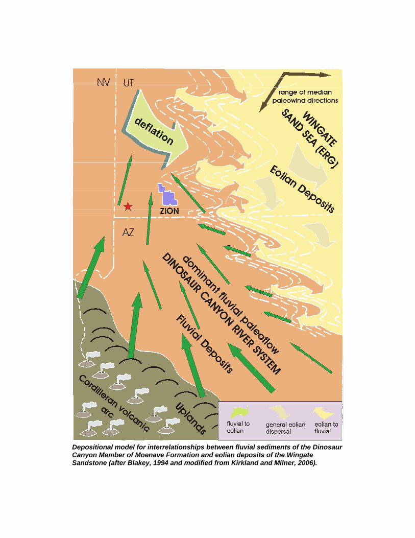
Depositional model for interrelationships between fluvial sediments of the Dinosaur Canyon Member of Moenave Formation and eolian deposits of the Wingate Sandstone (after Blakey, 1994 and modified from Kirkland and Milner, 2006).
Structural setting for deposition of uppermost Triassic and Lower Jurassic eolian deposits in the southwestern United States (after Blakey, 1994 and modified from Kirkland and Milner, 2006).
Structural setting for deposition of uppermost Triassic and Lower Jurassic eolian deposits in the southwestern United States (after Blakey, 1994 and modified from Kirkland and Milner, 2006).
LOWER CHINLE FORMATION ON LAND HILL WEST OF IVINS, UTAH
Generalized stratigraphic section showing the position of the Land Hill Tracksite on the top of a 7 to 8 m thick conglomerate dominated by chert clasts. The upper sandstone unit varies in thickness, and is the unit covered by petroglyphs on Land Hill (from Lockley and Milner, 2006).
View to the west of the Land Hill tetrapod and petroglyph sites. The Anisian upper red member of the Moenkopi Formation is poorly exposed on Land Hill, but tracksites have been found nearby. The red line marks the approximate unconformity between the top of the Moenkopi Formation and the Shinarump Member of the Chinle Formation (Carnian; Upper Triassic). The Land Hill Tracksite is indicated by the blue arrow. Petroglyphs are present along the west and northwest side of Land Hill in the upper sandstone unit of the Shinarump, overlooking the Santa Clara River. From Milner and Spears, 2007.
ST. GEORGE DINOSAUR DISCOVERY SITE AT JOHNSON FARM FIGURES
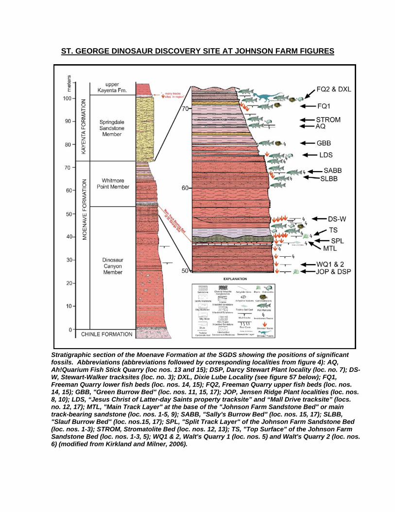
Stratigraphic section of the Moenave Formation at the SGDS showing the positions of significant fossils. Abbreviations (abbreviations followed by corresponding localities from figure 4): AQ, Ah!Quarium Fish Stick Quarry (loc nos. 13 and 15); DSP, Darcy Stewart Plant locality (loc. no. 7); DS-W, Stewart-Walker tracksites (loc. no. 3); DXL, Dixie Lube Locality (see figure 57 below); FQ1, Freeman Quarry lower fish beds (loc. nos. 14, 15); FQ2, Freeman Quarry upper fish beds (loc. nos. 14, 15); GBB, "Green Burrow Bed" (loc. nos. 11, 15, 17); JOP, Jensen Ridge Plant localities (loc. nos. 8, 10); LDS, “Jesus Christ of Latter-day Saints property tracksite” and “Mall Drive tracksite” (locs. no. 12, 17); MTL, "Main Track Layer" at the base of the "Johnson Farm Sandstone Bed" or main track-bearing sandstone (loc. nos. 1-5, 9); SABB, "Sally's Burrow Bed" (loc. nos. 15, 17); SLBB, "Slauf Burrow Bed" (loc. nos.15, 17); SPL, "Split Track Layer" of the Johnson Farm Sandstone Bed (loc. nos. 1-3); STROM, Stromatolite Bed (loc. nos. 12, 13); TS, "Top Surface" of the Johnson Farm Sandstone Bed (loc. nos. 1-3, 5); WQ1 & 2, Walt's Quarry 1 (loc. nos. 5) and Walt's Quarry 2 (loc. nos. 6) (modified from Kirkland and Milner, 2006).
Basal Moenave Conglomerate at Warner Valley.
Dinosaur Canyon Member below Middleton Black Ridge south of Museum
Main track layer and below during excavation for Museum.
Road cut through tracksite.
Map and paleoenvironmental interpretation of the SGDS MTL surface. A, Transect from museum site (A) on SGDS property (in gray) to swim track quarries (B) on WCSD and former DS (or Bodega Bay, LLC Property) properties. The estimated position of the paleoshoreline is indicated (hatched line) for the MTL based on orientation and preservation types of tracks, invertebrate traces, and sedimentary structures. B, Cross-section of transect A-B in A showing variation in bed thicknesses of the MTL and Top Surface. The estimated shoreline is for the MTL only. C, Map of the swim track quarries showing position of trough and transect A'-B' in B. D, Cross-section showing trough containing abundant swim tracks on the MTL surface, the variability in thickness of the MTL sandstone, and the Top Surface topography. Modified from Milner et al., 2006b; from Milner and Spears, 2007.
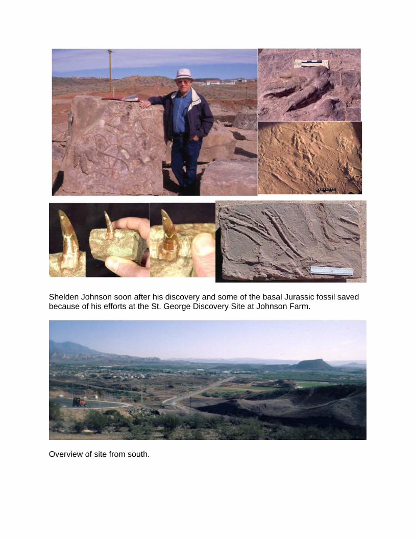
Shelden Johnson soon after his discovery and some of the basal Jurassic fossil saved because of his efforts at the St. George Discovery Site at Johnson Farm.
Overview of site from south.
Grallator-type swim tracks from the SGDS MTL. A, Block showing high density of parallel swim tracks (Field # SW.29). B, Down-current swim track set (Field # SW.104). C, “Normal” Grallator track in a down-current orientation (Field # SW.90). D, Elongate, up-current swim tracks (SGDS 167-4). E, Shorter, up-current swim tracks (Field # SW.103). F, Swim track set cross-cutting current in a more up-current direction (Field # SW.77). G, Grallator-type swim track showing claw mark, claw tip and scale scratch lines (SGDS 361). H, Close-up of claw tip, from G showing possible cuticle details (SGDS 361). Abbreviations: CFD, current flow direction; CT, claw tip; DT, direction of travel; PP, distal phalangeal pad; SD, swim direction; SSL, scale scratch lines. Scale in cm (from Milner and others, 2006b).
Some common sedimentary structures from the SGDS and vicinity. A, mud-crack natural casts (SGDS 10); B, Eubrontes and Grallator trackways with current ripples and joints (SGDS 18.T1); C, symmetrical wave-formed ripples (SGDS 620); D, tool marks (SGDS 262), sedimentary structures formed by objects such as mud clasts, rock, plant fragments, etc., bouncing and scraping along a submerged substrate; E, scratch circles (specimen number pending); F, sulfate salt-crystal casts (SGDS 40); G, raindrop impressions around a Pagiophyllum conifer branch (SGDS 491). From Milner and Spears, 2007.
Track cut by scour at base of main sandstone.
Map of the in situ SGDS “Top Surface” tracksite and portion of the “Main Track Layer” (MTL) (no. 1 on figure 4). Note the difference between lower MTL level, showing block outlines (top right), as map of the underside of the JFSB, and upper level, or “Top Surface” (bottom; catalog no. SGDS 18), which remains in situ. For clarity, cf. Gigandipus trackway with tail and crouching traces is shown separately (upper left) in the same orientation as it appears on the map. Note ridge and swale topography (erosive megaripples) and black arrows indicating selected local flow indicators on the “Top Surface.” The yellow arrows and dots represent a long Batrachopus trackway following the crest top of an erosive megaripple. Joints directed N57°E. From Milner and others, 2006c.
Erosive megaripples pre-museum.
Diagram showing the most likely model of erosive megaripple formation of the JFSB at SGDS museum site (based on Reineck and Singh, 1975, figure 8). Dinosaur track distribution and other associated sedimentary structures indicated (modified from Kirkland and Milner, 2006, figure 14E).
Lower Whitmore Point across from Museum.
Bedding plane view of Whitmore Point fish debris site under Fossil Ridge Intermediate School.
DIXIE LUBE SITE, BLUFF STREET, ST. GEORGE
Figure 57. The Dixie Lube Site along Bluff Street in St. George. A, Photo of the Dixie Lube locality. Lacustrine deposits of the Early Jurassic (Hettangian) Whitmore Point Member (Jw) of the Moenave Formation containing abundant fish and some thin stromatolite beds. Here a fluvial channel (Ch) cuts into the lacustrine deposits probably during a regressive period in Lake Dixie. The Whitmore Point is unconformably overlain by the Springdale Member (Js) of the Kayenta Formation (Sinemurian). B, Down section from A near the base of the Whitmore Point Member, the JFSB (described at SGDS on Day 1) is preserved, and natural casts of tracks are present. G = Grallator; SW = swim tracks. C, Close-up of an articulated fish in sideritic concretion (F) in cross-section and a thin stromatolite bed (S) among mudstone, shale and shale of lacustrine the Whitmore Point. From Milner and Spears, 2007.
Whitmore Point – Springdale contact and Springdale outcrop southwest of Museum.
I-15 ROAD CUT THROUGH MIDDLETON BLACK RIDGE, ST. GEORGE
Road cut on the southbound side of I-15 through Middleton Black Ridge. Early Jurassic silty facies of the Kayenta Formation is capped by Quaternary fluvial deposits (light brown outcrops), which are in turn overlain by a late Pleistocene basalt flow (black) that originally flowed down the channel of a tributary of the Virgin River (photo courtesy J. D. Harris). From Milner and Spears, 2007.
Type area of Whitmore point in northern Arizona.
Triassic-Jurassic Section at Zion National Park is pretty steep.
Photograph from Land Hill looking east toward the town of Ivins, and the Red and Pine Valley mountains. The photographer is standing on the top of the Shinarump Member of the Chinle Formation. The Petrified Forest Member of the Chinle and the entire Moenave Formation are covered by Quaternary alluvium in the valley. The lower part of Red Mountain consists of the Kayenta Formation (Jk), with the silty facies at the base and the “transition zone” between the Kayenta Formation and Navajo Sandstone (Jn) at the top. The Navajo Sandstone further to the east is above Snow Canyon State Park, and is capped by the late Pleistocene Santa Clara flow. In view below the Pine Valley Mountains is the Upper Cretaceous Iron Springs Formation (Kis) and the late Paleocene to late Eocene or early Oligocene Claron Formation (Tcl). From Milner and Spears, 2007.
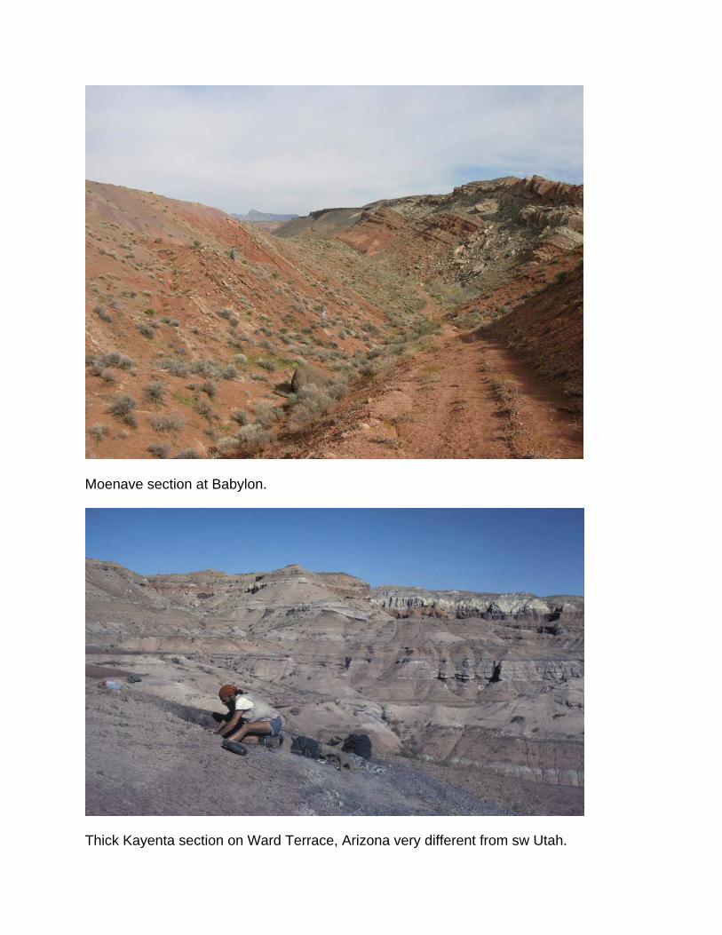
Moenave section at Babylon.
Thick Kayenta section on Ward Terrace, Arizona very different from sw Utah.
REFERENCES
Blakey, R.C., 1994, Paleogeographic and tectonic controls on some Lower and Middle
Jurassic erg deposits, Colorado Plateau, in Caputo, M.V., Peterson, J.A., and Franczyk, K.J., eds., Mesozoic systems of the Rocky Mountain region, USA: Denver, Rocky Mountain Section of the SEPM, p. 273-298.
Kirkland, J.I., and Milner, A.R.C., 2006, The Moenave Formation at the St. George
Dinosaur Discovery Site at Johnson Farm, St. George, southwestern Utah: New Mexico Museum of Natural History and Science Bulletin, v. 37, p. 289-309.
Lockley, M.G., and Milner, A.R.C., 2006, Tetrapod tracksites from the Shinarump
Formation (Chinle Group, Upper Triassic) of southwestern Utah: New Mexico Museum of Natural History and Science Bulletin, v. 37, p. 257-262.
Lucas, S.G., and Tanner, L.H., 2006, The Springdale Member of the Kayenta
Formation, Lower Jurassic of Utah-Arizona: New Mexico Museum of Natural History and Science Bulletin, v. 37, p. 71-76.
Lucas, S.G., Tanner, L.H., and Heckert, A.B., 2005, Tetrapod biostratigraphy and
biochronology across the Triassic-Jurassic boundary in northeastern Arizona: New Mexico Museum of Natural History and Science Bulletin, v. 29, p. 84-94.
Miller, W.E., Britt, B.B., and Stadtman, K., 1989, Tridactyl tracks from the Moenave
Formation of southwestern Utah, in Gillette, D.D., and Lockley, M.G., Dinosaur tracks and traces: Cambridge, Cambridge University Press, p. 209-215.
Milner, A.R.C., Ferris-Rowley, D., and Kirkland, J.I., 2006a, A BLM paleontological site
stewardship program for Washington County, southwestern Utah – the beginning of a nationwide program?: New Mexico Museum of Natural History and Science Bulletin, v. 34, p. 145-151.
Milner, A.R.C., Lockley, M.G., and Kirkland, J.I., 2006b, A large collection of well-
preserved theropod dinosaur swim tracks from the Lower Jurassic Moenave Formation, St. George, Utah: New Mexico Museum of Natural History and Science Bulletin, v. 37, p. 315-328.
Milner, A.R.C., Lockley, M.G., and Johnson, S.B., 2006c, The story of the St. George
Dinosaur Discovery Site at Johnson Farm – An important Lower Jurassic dinosaur tracksite from the Moenave Formation of southwestern Utah: New Mexico Museum of Natural History and Science Bulletin, v. 37, p. 329-345.
Milner, A.R.C., and Spears, S.Z., 2007. Mesozoic and Cenozoic paleoichnology of
southwestern Utah: Utah Geological Association Publication, v. 5, p. 1-85.