West Wide Climate Risk Assessments Columbia River Basin Climate Impacts Assessment FY2013 - 2016 Revised Scope of Work Pacific Northwest Region March 21, 2014 Toni E. Turner, Study Manager Bureau of Reclamation [email protected]
Transcript
West Wide Climate Risk Assessments
Columbia River Basin Climate Impacts Assessment FY2013 - 2016 Revised Scope of Work
2.8 Produce Technical Memorandum............................................................................................................. 6
2
TASK 3. IDENTIFICATION OF GROUNDWATER DOMINATED SYSTEMS .................... 7
3.1 Compile existing data relevant to understanding groundwater dominated systems ........... 7
3.2 Conduct a qualitative analysis of small basins in the Columbia River Basin to document groundwater influence ............................................................................................................................................ 7
3.3 Produce Technical Memorandum............................................................................................................. 8
4.1 Conduct reservoir modeling on the upper Snake River sub-basin and others sub-basins . 8
4.2 Update Pisces software as needed to evaluate Columbia River Basin results ...................... 10
4.3 Produce Technical Memorandum.......................................................................................................... 10
TASK 5. APPLICATION OF VIC ROUTED FLOW TO OTHER PN REGION NEEDS ......... 10
5.1 Conduct 1D hydraulic modeling using an existing, fully functional model (Design) .......... 11
5.2 Conduct 2D hydraulic modeling using an existing, fully functional model (Geology and River Analysis Systems Group) ......................................................................................................................... 12
5.3 Produce Technical Memorandum.......................................................................................................... 12
8.3 Internal PN Region review by participants ........................................................................................ 16
8.4 Edit internal draft report and produce Final Draft Report .......................................................... 17
8.5 Regional Director and other external review of the Final Draft Report .................................. 17
8.6 Finalize Final Report................................................................................................................................... 17
TASK 9. CLOSE OUT/LESSONS LEARNED ............................................................... 18
9.1 Host meeting to review process and discuss lessons learned ..................................................... 18
9.2 Produce close-out report .......................................................................................................................... 18
Table of Tables
Table 1: Columbia River Basin Impacts Assessment Methodology Selections. ................ 1
Table of Figures
Figure 1: HD quantile map features two empirical cumulative distribution function (CDFs), one of simulated flow during the bias identification period and another of the reference observed flows during this period. ...................................................................... 5
4
Introduction Revised Scope Overview This revision to the approved 2013 Scope of Work (SOW) and associated budget resulted from an unexpected issue with the daily Upper Snake River RiverWare model (R/W). The primary purpose for using R/W instead of the existing Upper Snake MODSIM model was the generation of daily data, which was seen as added value over the monthly data provided by MODSIM. During the performance of Task 4 described in the 2013 SOW, Pacific Northwest Region (PN Region) staff identified internal software issues in R/W, the resolution of which is beyond the programmatic scope of the Impacts Assessment. This revised SOW describes the modifications to work necessitated by the use of Modsim rather than R/W.
In addition to the modeling changes, the original Study Manager selected for this Assessment has been reassigned to other activities. As such, the Technical Lead identified in the SOW will now assume both roles. This SOW has been revised to adjust the responsibilities.
This SOW provides a mechanism to incorporate updates on Basin Study efforts in the PN Region, describes an opportunity for collaboration with Bonneville Power Administration (BPA) and the US Army Corps of Engineers (USACE) on recently funded research associated with generating future climate change flows using multiple hydrologic models, some of which will have an added glacier component, and downscaling and bias correction methods. It further identifies opportunities to fill the need for education on climate change basics principles and procedures to Regional staff.
Background The Columbia River Basin Climate Impacts Assessment (Assessment) is an activity of the West Wide Climate Risk Assessments (WWCRA), which is part of the Bureau of Reclamation’s (Reclamation) WaterSMART Basin Study Program (WaterSMART Program). This Program is authorized to address Section 9503 of the SECURE Water Act (SECURE) and Secretarial Orders 3289 and 3297 supporting the Department of Interior’s coordinated response to the changing climate and the WaterSMART Program. SECURE authorizes Reclamation to assess the risks to water supplies posed by climate change, including changes in snowpack, changes in timing and quantity of runoff, changes in groundwater recharge and discharge as well as changes in demands and consumptive usage within major river basins in the Western United States. SECURE further authorizes Reclamation to evaluate the impacts of climate change on specific components including water deliveries, hydropower, fish and wildlife habitat, Endangered Species
5
Act (ESA) species, water quality, flood control, flow and water dependent ecologic resiliency, and recreation at Reclamation facilities. It also directs Reclamation to work with appropriate stakeholders to develop and evaluate the feasibility of appropriate adaptation strategies.
Assessments establish baseline risks to water supplies and demands in each major Reclamation river basin. Assessments establish a foundation for more in-depth analyses and development of adaptation strategies through Basin Studies, operations planning, feasibility level analyses, or any other activity that can benefit from the Assessments.
This Assessment will quantitatively evaluate the impacts associated with climate change as they relate to the mission of Reclamation including risks to water supplies (change in snowpack, changes in timing and quantity of runoff, and changes in groundwater recharge and discharge) and any increase in the demand for water as a result of increasing temperatures and the reservoir evaporation rates for the Columbia River Basin. This Assessment will analyze the impacts of these changes on water delivery, power generation, recreation at Reclamation facilities, flood control, and ecological resources (fish and wildlife habitat, ESA species, water quality, and flow and ecological resiliency) to the extent possible. To identify the risks and impacts, the Assessment will use the best available science and climate information within a planning context at the reconnaissance level.
Specific implementation activities in this Assessment will include:
a) Generation of future flows at to-be-determined locations across the Columbia River Basin using the 1/16th degree Variable Infiltration Capacity (VIC) model to project future changes in water supply, analyze the impacts of those changes, and use these data as input to other water resource models.
b) Evaluation of the recently completed evapotranspirative (ET) depletions generated by the Technical Services Center (TSC) in FY2012 for the PN Region;
c) Simulation of impacts of future climate change flows on operations of Reclamation projects using the upper Snake River MODSIM model;
d) Simulation of impacts of future climate change flows on Reclamation activities other than operations including (e.g., engineering design, habitat restoration) using simulated historical and future climate change flows developed in (a);
e) Regular communication with the Regional Director, Regional Staff, and coordination with external stakeholders, potentially including BPA, USACE, United States Fish and Wildlife Service (USFWS), National Marine Fisheries Service (NMFS), the Federal Columbia River Power System (FCRPS) Caucus (Caucus), and interested Tribes to inform them of Reclamation’s activities in fulfillment of our mission, become aware of sensitivities of external stakeholders
6
due to their ongoing efforts to fulfill objectives specific to their missions, and coordinate as necessary to meet Reclamation’s study objective.
The results of Tasks 1-9, which are summarized below and described in detail on the following pages and specific activities (a) – (e) will then be used to identify the potential impacts of climate change, at specified time periods in the future, on water delivery, hydroelectric power generation, recreation, fish and wildlife habitat, endangered, threatened, or candidate species under the ESA, water quality, ecological resiliency, and flood control as identified in SECURE.
Tasks 1-9 are as follows:
Task 1: Project Management
Task 2: Climate Change Analysis and Hydrologic Modeling
Task 3: Identification of Groundwater Dominated Systems
Task 4: Reservoir Modeling
Task 5: Application of VIC Routed Flow to Other PNRO Needs
Task 6: Meetings/Public/Stakeholder Outreach
Task 7: GIS Coordination and Assistance
Task 8: Final Report
Task 9: Close out/Lessons Learned
Climate change analyses on some activities, such as hydropower production on the mainstem Columbia River, will be obtained from previously completed efforts (e.g., River Management Joint Operating Committee (RMJOC) Climate Change Study 2011) and reported in this Assessment. The RMJOC Climate Change Study results have also been used in more detailed Basin Studies. The Ecological Resources Framework, currently being finalized by the WWCRA Implementation Team, will help establish sideboards for the level of analysis of the four ecosystem related components of SECURE (fish and wildlife habitat, ESA species, water quality, and ecological resiliency).
Several WaterSMART Basin Studies have been or are being conducted in the Columbia River Basin. These include:
7
• Yakima River Basin. This Basin Study was completed in 2011 as part of an integrated effort to understand the water supply and demand issues in that sub-basin. A Yakima Basin Integrated Water Resource Plan (Integrated Plan) addresses water resource and ecosystem issues focusing on seven elements that include fish passage, structural and operational changes to the reservoir system, surface and ground water storage, habitat protection and enhancement, enhanced water conservation, and market reallocation options.
• Henrys Fork Basin. This Basin Study is a tributary to the Snake River, selected in 2010 and is planned for completion in April 2014.
• Hood River Basin. This Basin Study was selected in FY2011 and is planned for completion in June 2014.
• Willamette River Basin. This Plan of Study was initiated in FY2013 and is planned for completion in September 2014.
Results of these efforts will continue to be monitored and results reported in this Assessment as appropriate.
Objective The objective of the Assessment is to analyze how climate change may affect future water supply, alter demands and impact Reclamation’s responsibilities related to water delivery, hydroelectric power generation, recreation, ecological resources (fish and wildlife, water quality, and ecological resiliency), ESA species (endangered, threatened and candidate), and flood control management in the Columbia River Basin. In addition to an analysis of these impacts, the completed Assessment also will result in identification of basins in the Columbia River Basin to be considered for future Basin Studies in the PN Region under the WaterSMART program.
Deliverables In addition to a series of technical memorandums (TM) completed in the identified Tasks, a Final Columbia River Basin Impacts Assessment Report (Report) summarizing the work conducted for the Assessment and detailing the methods and results of the analysis will be provided. Details about the Report process are in Task 8.
1
Task Descriptions
Task 1. PROJECT MANAGEMENT
1.1 Meetings, notes, management details, prep for meetings
Project meetings will consist of both internal and external stakeholder meetings.
A PN Region Project Team will be established early in the process to include major participants in the completion of the Tasks identified in this SOW. This may include staff from the PN Regional Office, Cascades-Columbia Area Office, Snake River Area Offices, and Field Offices as appropriate. The PN Region Project Team meetings are scheduled by the Study Manager to occur bi-weekly for brief group-wide updates, to seek collaborative input and guidance on multi-disciplinary questions, and identify issues as they may arise.
In addition to regular meetings with PN Region Project Team members, the Study Manager will provide briefings to Regional Management on a regular basis or as issues arise.
External meetings will be held via teleconference with interested external stakeholders, potentially including BPA, the USACE, USFWS, NMFS, the Federal Caucus, and interested Tribes. Points of contact for the agencies and the Federal Caucus will be requested to attend at least twice-yearly telephonic conference calls with the Study Manager. The purpose of these meetings will be to inform specific external stakeholders of Reclamation’s Assessment activities, be aware of sensitivities of external stakeholders due to their ongoing efforts to fulfill objectives specific to their missions, and coordinate as necessary to meet Reclamation’s Assessment objectives.
All meetings held for the purpose of advancing this Assessment, whether internal or external, will be documented by written notes prepared by the Study Manager. Draft meeting summaries will be disseminated to meeting attendees within three days of the meeting and a final version filed no more than two weeks of the meeting. These meeting summaries will be posted to the Reclamation website (Task 6) as well.
2
1.2 Progress reports The Study Manager will be responsible for overseeing the administration of the Assessment (scope, schedule, budget, etc.). The Study Manager for this Assessment is the WWCRA Implementation Team POC and will provide verbal progress updates to that team in accordance with the standing agenda at their current bi-weekly calls.
A written status update will be provided to WWCRA Implementation Team on a quarterly basis
The WWCRA Implementation Team will be responsible for providing feedback on the technical conduct of the Assessment during the updates provided by the Study Manager. Following each quarterly report, the WWCRA Implementation Team will provide feedback to the Study Manager about the technical approach, the level of detail of the analysis, and may suggest adjustments if appropriate. The Study Manager will be responsible for keeping the Regional Director and Regional management informed of the progress of the Assessment and any feedback received from the WWCRA Implementation Team. The WWCRA Implementation Team is ultimately responsible for overseeing and approving the technical aspects of the Assessment in cooperation with the Regional technical staff.
1.3 Scope/budget development, updating This document, along with the attached budget and schedule, comprise the proposed Scope of Work (SOW) for this Assessment. The PN Regional Director will continue to be briefed on the SOW’s contents and her/his role in this process.
Should issues arise with execution of the SOW relating to the scope, budget, schedule, or overall quality control, the Study Manager will discuss them immediately with the PAO point of contact to ensure timely completion of a quality study that meets program objectives. The Study Manager will be responsible for completing and disseminating all SOW revisions to the PN Region Project Team, WWCRA Implementation team, and PAO.
1.4 Overall coordination in the PN Region, Denver TSC, and Denver PAO
The communications management plan is broadly framed to meet the study objectives but will also have specific metrics as described throughout this SOW. The PN Region
3
Project Team will coordinate on technical and administrative issues in the PN Region, Technical Services Center (TSC), and the Policy and Administration Office (PAO) through the Study Manager. PN Region staff will provide updates to the three Landscape Conservation Cooperatives (LCCs) associated with the PN Region, specifically, the Great Basin, Great Northern, and Northern Pacific LCCs and to the PNW Climate Science Center.
Because of the on-going work that the TSC and the Research and Development Offices are doing related to improving the hydroclimate datasets, methods for their use, and approaches to generating useable, planning scale hydroclimate data that may affect this Assessment, frequent communication between the Study Manager and Denver staff is expected. No formal meetings are scheduled, but this may be adjusted if the advancement in technology warrants it.
Task 2. CLIMATE CHANGE ANALYSIS AND HYDROLOGIC MODELING
Task 2 includes reviewing and reporting climate change study results on the mainstem Columbia River Basin using the RMJOC Climate Change Study, collaborating with the PN Region Project Team to determine and prioritize the sub-basins in the Columbia River Basin in which analyses from the Assessment will take place, obtaining PN Region Project Team concurrence on the overall methodology and future windows of interest (in collaboration with PAO) and generating future flow at prioritized locations as a result of those determinations.
2.1 RMJOC Climate Change Study review for mainstem Columbia River
The Columbia River Basin is almost 260,000 square miles and 1,250 miles long including part of Canada and states in the Pacific Northwest. The Federal Columbia River Power System (FCRPS) has 14 facilities, two of which are owned and operated by Reclamation, including Grand Coulee, the largest hydropower generating facility in the United States. BPA markets the power generated by FCRPS facilities. FCRPS facilities are located on the mainstem and tributaries. Many other projects are located on tributaries and are authorized for uses such as water delivery, flood control, ecological resource support, and recreation. These facilities are primarily owned and/or operated by Reclamation, the USACE, other agencies, PUDs, and private entities.
To document the impact of climate change on the Federal hydropower system and
4
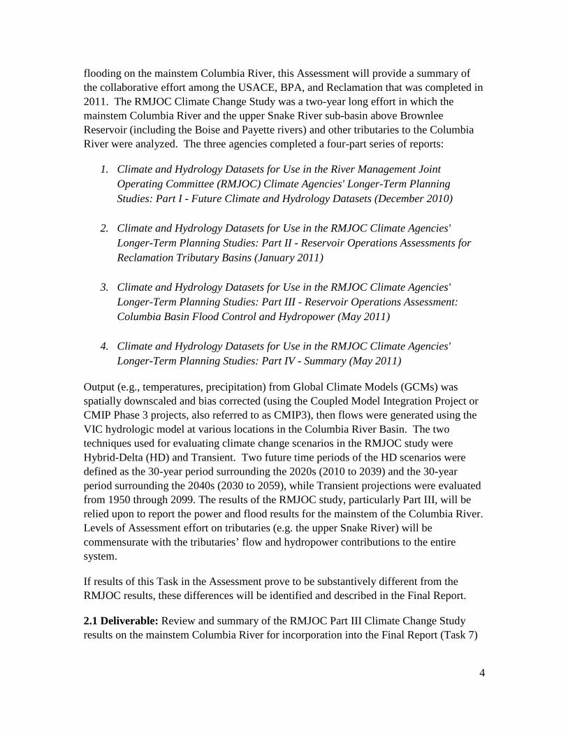
flooding on the mainstem Columbia River, this Assessment will provide a summary of the collaborative effort among the USACE, BPA, and Reclamation that was completed in 2011. The RMJOC Climate Change Study was a two-year long effort in which the mainstem Columbia River and the upper Snake River sub-basin above Brownlee Reservoir (including the Boise and Payette rivers) and other tributaries to the Columbia River were analyzed. The three agencies completed a four-part series of reports:
1. Climate and Hydrology Datasets for Use in the River Management Joint Operating Committee (RMJOC) Climate Agencies' Longer-Term Planning Studies: Part I - Future Climate and Hydrology Datasets (December 2010)
2. Climate and Hydrology Datasets for Use in the RMJOC Climate Agencies' Longer-Term Planning Studies: Part II - Reservoir Operations Assessments for Reclamation Tributary Basins (January 2011)
3. Climate and Hydrology Datasets for Use in the RMJOC Climate Agencies' Longer-Term Planning Studies: Part III - Reservoir Operations Assessment: Columbia Basin Flood Control and Hydropower (May 2011)
4. Climate and Hydrology Datasets for Use in the RMJOC Climate Agencies' Longer-Term Planning Studies: Part IV - Summary (May 2011)
Output (e.g., temperatures, precipitation) from Global Climate Models (GCMs) was spatially downscaled and bias corrected (using the Coupled Model Integration Project or CMIP Phase 3 projects, also referred to as CMIP3), then flows were generated using the VIC hydrologic model at various locations in the Columbia River Basin. The two techniques used for evaluating climate change scenarios in the RMJOC study were Hybrid-Delta (HD) and Transient. Two future time periods of the HD scenarios were defined as the 30-year period surrounding the 2020s (2010 to 2039) and the 30-year period surrounding the 2040s (2030 to 2059), while Transient projections were evaluated from 1950 through 2099. The results of the RMJOC study, particularly Part III, will be relied upon to report the power and flood results for the mainstem of the Columbia River. Levels of Assessment effort on tributaries (e.g. the upper Snake River) will be commensurate with the tributaries’ flow and hydropower contributions to the entire system.
If results of this Task in the Assessment prove to be substantively different from the RMJOC results, these differences will be identified and described in the Final Report.
2.1 Deliverable: Review and summary of the RMJOC Part III Climate Change Study results on the mainstem Columbia River for incorporation into the Final Report (Task 7)
5
and documentation of any differences between Assessment results and the RMJOC work.
2.2 Geographic scale The PN Region has a significant presence throughout the CRB, with several programs conducted in response to actions affecting hydrology, power generation, and ecological resources. These include the Columbia Snake Salmon Recovery Office Tributary Habitat Program (THP), Regional Resource and Technical Services (RTS) programs, and various programs at the Snake River Area Office (Boise and Burley field office locations) and Columbia-Cascades Area Office (CCAO). CCAO has field offices Washington (Yakima and Ephrata) and Oregon (Bend and Umatilla/Hermiston).
A key aspect of this Assessment is to generate future flow at locations throughout the Columbia River Basin, with specific areas of focus for further analysis in this Assessment to be determined by the PN Region Project Team in coordination with Regional staff. As described in Sub-Task 2.1, the RMJOC Climate Change Study results will be used to report results on the mainstem Columbia River system. Along with this mainstem information and in response to the required elements of 9503(b) in SECURE, tributary flow locations and future flows will be determined in collaboration with PN Region staff. Future flow results will be incorporated into existing water resource models to analyze the impacts of water supply changes on reservoir operations and ecological resources (Task 4 and Task 5).
Specific sub-basins will be selected with existing, fully-functional impacts models to which future flows will be applied to better understand the impacts of integrating future flow into the PN Region’s ongoing activities, such as reservoir operations and habitat rehabilitation design activities in the THP.
Another key outcome of the Assessment will be identification of sub-basins suitable for more adaptation analyses in the Basin Study Program through Basin Studies. The method for identifying potential sub-basins will be developed collaboratively in the PN Region.
2.2 Deliverable: PN Region Project Team will provide a map indicating the geographic scale of Assessment including identification of all sub-basins of interest to PN Region management for concurrence. Those sub-basins that could be considered in more detailed Basin Studies will also be identified. Locations at which naturalized flow is developed or VIC simulated historical and simulated future climate change flows are developed will be mapped as well.
6
2.3 Determine methodology Decisions needed to assess climate change impacts include selection of climate change characterization methods, future time periods of interest, range of projection, and preferred project approach. The PN Region Project Team will discuss the list of choices provided in Table 1 that frame the methodology needed to address climate change in this Assessment. While some of these choices have already been resolved, the PN Region Project Team members will be provided with an opportunity to learn and comment on the selected methodologies. Table 1 provides a summary of the steps and methodology selections that have been made or are yet-to-be determined.
1
Table 1: Columbia River Basin Impacts Assessment Methodology Selections.
Step
Description of Step
Choices Selection for use in Assessment Guidance for
Selection Decisions
Steps Resolved (yes/no)
1 Select Global Climate
Projection Context
CMIP3 or CMIP5 CMIP5
WWCRA, R&D
Yes
2 Select how future
climate will be
characterized
Period-change (Delta or Hybrid Delta) or transient Period change Delta method with sensitivity informed by HD
WWCRA & R&D
Yes
3
Select number of
change scenarios
Selections by 10/90 percent, 25/75 percent
leading to MW/W, MW/D, LW/W, LW/D, C
– do we use them all or some?
Selecting five change scenarios bracketed by Less Warming/Drier (LW/D), Less Warming/Wetter (LW/W), More Warming/Wetter (MW/W), and More (MW/D) Warming/Drier. A fifth scenario
indicating the central change (50 percent) will be selected as well.
For sensitivity analysis, two to three HD change scenarios with greatest change (tbd) will be selected for comparison to the Delta results (it is not expected that these will be processed through the
impacts models).
WWCRA, R&D, PNRO
Mostly, but a Project Team discussion is needed to confirm percentiles of
interest.
4 Select whether change
Single projection or ensemble Ensemble (nearest 5 or 10 to intersection)
R&D, PNRO
Yes (ten)
2
scenarios informed by
a single projection or an ensemble
of several
5 Depending on the above
decisions, determine options for generating hydrology
Use existing available future hydrology or generate new future
hydrology consistent with climate assumptions made
above with original modeling?
Generate new future hydrology
WWCRA, PNRO
Yes
5a
If generating new
hydrology, select model
VIC 1/16th or 1/8th degree grid and routing tool
(other hydrologic models are available)
Select VIC 1/16th degree grid model and routing tool for routing flow to selecting locations (VIC model has been applied to CRB already
through the RMJOC Climate Change Study)
For generating future climate-adjusted weather under each climate change scenario, 1/8th degree P and T changes computed from the
1/8th degree BCSD CMIP5 climate projections will have to be interpolated to 1/16th degree before being used to adjust the 1/16th
degree "base historical" weather data developed by UW CIG.
WWCRA, PNRO
Yes (1/16th)
3
5b
If generating new
hydrology, determine
flow routing locations of
interest
Identify locations in the sub-basin of interest that
have gages with long term PORs to “train” simulated
historical and future climate change flows to
Several key locations have been identified in previous efforts (RMJOC Climate Change Study) and will continue to be used.
Additional sites will be identified by the PN Region Project Team.
WWCRA, R&D, PNRO
Partially. As a result of recent collaboration with
BPA and the USACE, naturalized flows have been
generated for input into VIC for the upper Snake, Deschutes, and Yakima
rivers. Also, the other two agencies have developed
over 300 additional points Columbia River Basin-
wide. Because of this new development, Reclamation
will generate VIC simulated historical and simulated future climate change flows using the approaches identified in previous steps at all of
these locations for use by our stakeholders. Areas
outside of the Reclamation study areas will not be
evaluated further in this Assessment, but differences
between the CMIP3 data generated in the RMJOC
Climate Change Study and this effort will be compared as stated in Sub-Task 2.1.
1
Additional information on each step is provided as follows:
1. Select Global Climate Projection Context (CMIP3 or CMIP5 or a mix of both) 2. Due to the timing of the Assessment initiation, the World Climate Research
Programme's (WCRP's) Coupled Model Intercomparison Project Phase 5 (CMIP5) will be available for use. Reclamation’s Technical Service Center (TSC) is bias correcting and downscaling over 100 GCMs with two Representative Concentration Pathways (RCPs) at 1/8th degree. These data should be available for use by Assessment initiation.
3. The Period change technique (i.e., Delta with sensitivity conducted using Hybrid-Delta) will be selected.
4. Ensembles of future climate will be selected centered on a specific percentile change in T and P (e.g., 10/90 percent or 25/75 percent change in T and P) or use of a single projection that is the nearest to that percentile of choice.
5. Five bracketing scenarios will be selected that represent the intersections of the percentile changes. Selection of the percentile of choice will be determined by the PN Region team (#4). The bracketing scenarios will include Less Warming/Drier (LW/D), Less Warming/Wetter (LW/W), More Warming/Wetter (MW/W), and More Warming/Drier (MW/D). A fifth scenario indicating the central or median change (50 percent) will be selected as well.
a. To address sensitivity of the Delta ensemble method, between two and three additional scenarios reflecting the greatest change in mean annual temperature (T) and mean annual precipitation (P) will be scoped using the Hybrid-Delta ensemble method. Use of these additional sensitivity scenarios in water resource modeling is not planned.
6. Hydrology Model a. An existing VIC 1/16th degree gridded model has been used in the past in
the Columbia River Basin (House Bill 2860). This model and routing tool will be used in this Assessment, except future climate-adjusted weather will be interpolated to 1/16th before being used. The available options for future hydrologic analysis include using those that have been generated for the RMJOC Climate Change Study. This RMJOC effort was completed using CMIP3 climate data at 1/16th degree grid that were generated through the Washington State House Bill 2860 work.
b. Flow routing locations of interest will be determined in Task 2.4.
A known limitation of the RMJOC Climate Change Study also will be addressed in the Assessment. In the RMJOC Climate Change Study, the climate change projections that were selected for use in the study were spatially downscaled over the Columbia River Basin. This selection process led to the unintentional selection of primarily wetter future scenarios in the upper Snake River sub-basin. Other climate change projections will be selected to ensure that drier climate futures are evaluated in the upper Snake River sub-basin as a result of this Assessment.
2.3 Deliverable: Technical documentation of the approach, projections selected, and results.
2.4 Determine flow routing locations Locations for future flow routing will be identified and prioritized in collaboration with PN Region staff. The results and methods will be documented after the PN Region Project Team has provided their input. These locations will be based on the needs of the MODSIM operations’ model in the upper Snake River and its major tributaries in addition to those needs identified by other regional participants (e.g., RTS, Area Offices, and Columbia-Snake River Office).
One of the other participants identified in this Assessment is Columbia-Snake River Office’s THP. In addition to this already identified collaborator, RTS groups such as Design, Ecosystems Analysis, River and Reservoir Operations, Geology and River Analysis System, and Facilities along with staff from the Area Offices will coordinate to fully scope this Task to ensure that flow routing locations are identified, prioritized, and simulated flows generated so this Assessment may support the needs of the entire PN Region as resources allow.
2.4 Deliverable: Identification of flow routing locations by the PN Region Project Team to be analyzed in the Assessment. This task’s deliverable is built upon previous tasks discussed earlier in Section 2.
3
2.5 Hydrologic model calibration, natural flow generation
As described in Table 1, Step 5a, the 1/16th degree (~8 kilometer grids) VIC model was selected for use in this Assessment. This model was calibrated at a number of locations across the Columbia River Basin as part of the RMJOC Climate Change Study (2011). This calibration effort will not be repeated at this scale.
Reclamation generated observed historical flows in the upper Snake, Deschutes, and Yakima river basins in response to BPA’s research and the USACE. Of these basins, the VIC model will be re-calibrated in the upper Snake River Basin prior to generating simulated historical and simulated future climate change flows. In addition, other small basins identified for inclusion in this Assessment by the PN Region Project Team will be re-calibrated as appropriate.
The recent collaboration with BPA and the USACE has also resulted in the generation of almost 400 naturalized flow time series throughout the Columbia River Basin. Additional naturalized flow will be generated based on the PN Region Project Team needs.
2.4 Deliverable: Produce observed historical flows that have the effect of operations, depletions, etc., removed throughout the Columbia River Basin and in smaller basins identified by the PN Region Project Team. Recalibrate upper Snake River Basin and other basins in which water resource modeling will occur as part of this Assessment. Comparison of the results with previous study results (e.g., RMJOC Climate Change Study) will be conducted. This task’s deliverable is built upon previous tasks discussed earlier in Section 2.
2.6 Generate simulated historical and simulated future climate change flows and bias correction
The locations and their associated time series of observed historical naturalized flow will be used in the current VIC model to generate simulated historical and future climate change flows throughout the Columbia River Basin using approaches outlined in this Assessment. As described in Task 2.5, the VIC model will be used to generate flows Columbia River Basin-wide. In addition, this hydrologic model will be re-calibrated in the upper Snake River basin and other small basins identified for further analysis in this Assessment. However, additional steps to remove biases in the simulated flows may be
4
needed. This is because the routed VIC monthly stream flows generated have a high degree of relative accuracy, but a much lower degree of absolute accuracy. This is, in part, because the VIC model routes only surface flow, and does not account for interactions of surface flow with groundwater systems or withdrawal of surface water for agricultural use. The simulated historical stream flow, therefore, needs to be corrected for bias by comparing them with observed historical flows.
Due to a significant variance in stream flow distributions among the tributary nodes, bias correction will be performed independently for each tributary inflow location (rather than through bias correction to one index location, and applying that bias correction to all locations). Bias correction will be performed on the output Columbia River Basin-wide and after re-calibration of the upper Snake River and other small basins within the Columbia River Basin.
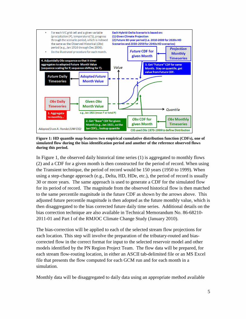
In this process, simulated historical VIC flows will be mapped (or “trained”) to observed historical gaged flow that has been naturalized (has had the impacts of operations, depletions, etc. removed) generated for the water resource modeling using quantile mapping (Figure 1). In this procedure the quantile map features two empirical cumulative distribution function (CDFs), one of which is the simulated historical flow generated by using the bias identification period (to be selected) and another of the “reference” historical observed flows (that are naturalized) during the gaged period of record (the time periods do not have to match). The CDFs are constructed at a given runoff location, first on a month-specific basis to characterize bias on monthly mean flows and then on an annual basis to characterize bias in the annual mean flow. After defining these CDFs, bias correction of simulated historical flow to observed historical is conducted. The quantile maps are used to generate VIC simulated stream flow simulation bias for a given stream-flow magnitude.
5
Figure 1: HD quantile map features two empirical cumulative distribution function (CDFs), one of simulated flow during the bias identification period and another of the reference observed flows during this period.
In Figure 1, the observed daily historical time series (1) is aggregated to monthly flows (2) and a CDF for a given month is then constructed for the period of record. When using the Transient technique, the period of record would be 150 years (1950 to 1999). When using a step-change approach (e.g., Delta, HD, HDe, etc.), the period of record is usually 30 or more years. The same approach is used to generate a CDF for the simulated flow for its period of record. The magnitude from the observed historical flow is then matched to the same percentile magnitude in the future CDF as shown by the arrows above. This adjusted future percentile magnitude is then adopted as the future monthly value, which is then disaggregated to the bias corrected future daily time series. Additional details on the bias correction technique are also available in Technical Memorandum No. 86-68210-2011-01 and Part I of the RMJOC Climate Change Study (January 2010).
The bias-correction will be applied to each of the selected stream flow projections for each location. This step will involve the preparation of the tributary-routed and bias-corrected flow in the correct format for input to the selected reservoir model and other models identified by the PN Region Project Team. The flow data will be prepared, for each stream flow-routing location, in either an ASCII tab-delimited file or an MS Excel file that presents the flow computed for each GCM run and for each month in a simulation.
Monthly data will be disaggregated to daily data using an appropriate method available
6
for the site. For example, one method uses a reference site to pattern daily flows after while another (if the reference site is not available) use an average of the monthly flow. The PN Region Project Team will determine the most appropriate approach for disaggregation of monthly flows.
Based on input from PN Region Project Team representatives, the VIC routing tool will be updated to generate flow at key areas of interest in the PN Region. The number of locations and the sub-basins selected will be based on the amount of time required to update the routing tool and generate flows. This process will be automated to the greatest extent possible so that flow can be more easily generated in those sub-basins that are potential candidates for future Basin Studies.
2.5 Deliverable: Simulated historical and future climate change flows will be generated throughout the Columbia River Basin. Bias correction of simulated flows will be performed. Methods and results will be documented for inclusion in Task 2.8.
2.7 GIS Coordination Significant coordination will take place with GIS staff to initiate the development of an interactive map that regional staff can refer to and download observed historical, simulated historical, and simulate future climate change flow data for their location of interest. This work is being coordinated with the Policy and Administration Office to establish an approach that will be used west-wide. See Task 7 for more information on GIS efforts and deliverables.
2.8 Produce Technical Memorandum A Technical Memorandum documenting and summarizing the methodology, approach, and results of the Task 2 efforts will be prepared as the deliverable for Task 2.8 for inclusion as an appendix to the Final Report (Task 7).
7
Task 3. IDENTIFICATION OF GROUNDWATER DOMINATED SYSTEMS
3.1 Compile existing data relevant to understanding groundwater dominated systems
There are Reclamation-influenced basins that have significant groundwater-surface water interaction and are expected to be impacted by climate change in the Columbia River Basin (e.g., Deschutes River Basin, Snake River Plain adjacent to the Snake River). Because VIC does not capture groundwater flow well, this aspect of water supply will not be fully evaluated in this Assessment. However, any available electronic, paper, or digital data available (e.g., geology, soils, vegetation, aquifer information) will be assembled to conduct a qualitative evaluation of groundwater influence in basins in the Columbia River Basin.
The Deschutes River sub-basin is currently being studied by the Department of Energy. Their current scope does not include studying the impacts of climate change, however Reclamation is anticipating using already-constructed models or those generated as part of that work to conduct climate change analyses in FY2014 under a Basin Study. Modeling that considers the impacts of groundwater interaction with surface water is being conducted, which is more appropriate for the Deschutes River given its dominance by groundwater. Results of this effort will included in the compilation of data as appropriate and reported as necessary.
3.2 Conduct a qualitative analysis of small basins in the Columbia River Basin to document groundwater influence
The PN Region Project Team in collaboration with Regional staff will identify and summarize pertinent information for basins in the Columbia River Basin that are dominated by groundwater.
In addition, a groundwater subgroup to the WWCRA Implementation Team is currently evaluating how groundwater dominated basins can be included in the future WWCRA activities. Any applicable results that are available during the performance of this Assessment will be documented.
8
3.3 Produce Technical Memorandum A Technical Memorandum documenting and summarizing the methodology, approach, and results of the Task 3 efforts will be prepared as the deliverable for inclusion as an appendix to the Final Report (Task 8).
Task 4. RESERVOIR MODELING
4.1 Conduct reservoir modeling on the upper Snake River sub-basin and others sub-basins
In 2011, Reclamation completed the RMJOC Climate Change Study (2011), which was a collaborative effort with the USACE and BPA. The upper Snake River MODSIM model (v8.1) was used to determine the potential effects of 19 climate change projections (six HD 2020s, six HD 2040s, and six Transient plus a historical simulation) on five major metrics in the upper Snake River sub-basin (i.e., inflow to reservoirs, reservoir elevation and volume, flow at specific locations, and flow augmentation impacts).
This task includes using the observed historical (naturalized), the simulated historical, and the simulated future climate change flows generated in Task 2 as input to the upper Snake River MODSIM and conducting an analysis of associated output (from the models with and without operations). This Task also includes a more robust, detailed analysis of the output at areas including and upstream of Brownlee Reservoir on the Snake River and at key locations upstream. Some of these additional locations might include facilities on the Boise and Payette river systems as well.
Possible output parameters to be analyzed in this Assessment include:
• Change in winter or cool season flows • Change in annual flow • Change in summer or warm season flows and precipitation (indication of
monsoon) • Change in spring flows • Reservoir elevations, inflow, outflow • Flow augmentation • Ecological resources connected to reservoir operations
For the upper Snake River above Brownlee Reservoir, significant time and resources
9
were invested in the RMJOC Climate Change Study to verify that the output parameters at Brownlee Reservoir were correct, given the new climate change inflow at Brownlee Reservoir and upstream. It was known at that time that areas further upstream in the watershed (e.g., Henrys Fork) would need additional analysis and would likely require more routed inflow locations in the basin to better capture potential future changes. This additional analyses is included in this Assessment.
In addition to additional analyses as described above, the following subtasks will be completed to update the existing monthly MODSIM model (latest version) prior to its use in execution of this SOW.
• Water right priority dates in the MODSIM model will be verified against the State of Idaho’s records.
• Water right priority dates downstream of a control point (Milner Dam) will be adjusted so they do not compete with upstream priorities, or the model structure will be altered so competition cannot occur.
• Custom code controls various model operations. Validation of the objectives and logic in the custom code for current operations will be conducted.
• Verify that custom code control of flow augmentation requirements is being correctly performed, and verify that flow augmentation water is not modeled as being diverted by any downstream water user.
• Determine whether the hydrologic state may remain based only on a volume forecast or should be modified to also be based on reservoir contents; execute as necessary.
• Calibrate and validate modeled reservoir operations/targets using more recent period of record data subsets to be representative of current operations.
• Verify the embedded "mini-networks" that "watch" model operations or distribute flow.
• Upgrade the hydropower units to the new model structure and verify that hydropower calculations are being correctly performed.
• Update the network integer solver to decimal precision, which may require adjustments to existing custom code.
• Convert static groundwater responses to dynamic responses to be calculated within MODSIM.
The PN Region is working with the developer of MODSIM to obtain the software code so that Reclamation no longer relies on the developer for technical support.
4.1 Deliverables: The MODSIM simulations will generate a monthly time series of flow that will be evaluated including regulated stream flow at specific locations, reservoir elevations, reservoir releases, crop consumptive use, etc. The PN Region Project Team
10
will develop a specific list of variables to evaluate using the simulated VIC generated flows.
4.2 Update Pisces software as needed to evaluate Columbia River Basin results
Pisces is a desktop application created by the PN Region River and Reservoir Operations staff and is designed to organize, graph, and analyze natural resource data that varies with time such as gauge height, river flow, and water temperature. Pisces provides convenient access to time series model results and the ability to easily compare many different scenarios or alternatives. Unique to Pisces is a scenario selector that converts massive amounts of output data into a summary form for each time series by scenario/alternative. Minor updates or revisions may be necessary to incorporate selection of CMIP5 data and flow results. This task provides time and resources for those revisions to the software to be completed.
4.2 Deliverables: Documentation and delivery of updated Pisces software package.
4.3 Produce Technical Memorandum A Technical Memorandum documenting and summarizing the methodology, approach, and results of the Task 4 efforts will be prepared as the deliverable for inclusion in the Final Report (Task 8).
Task 5. APPLICATION OF VIC ROUTED FLOW TO OTHER PN REGION NEEDS
In addition to understanding the impacts of water supply changes due to climate change on reservoir operations, this Assessment will include application of simulated historical and simulated future climate change flows in water resource models other than reservoir operations’ models (e.g., hydraulic models, ecosystem models). This step is significant because simulated flows can vary from time step to time step more so than in historical flows that were developed assuming stationarity. This variance can cause major instabilities in a water resource model that requires the development of work-arounds to continue to use the model. The process of identifying inflow locations, generating naturalized flow, and incorporating simulated historical and simulated future climate change flow into a hydraulic model (for example) also has a learning curve.
11
As described in Task 2, using simulated future climate change flow in water resource impacts models that are constructed using the observed historical record requires adjustment be made to standard input processes and analyses. However, those adjustments needed are not known until future flow analyses are attempted using flows simulated using VIC or another hydrologic model.
As a result of performing this Task, other groups in the PN Region will have the opportunity to prepare for the mainstreaming of climate change in all Reclamation programs, projects, and activities. This effort will help Regional employees in the paradigm shift that is incorporating future climate change flows into work products and understanding climate change analyses becomes more prevalent in all of Reclamation activities (DOI Climate Change Policy December 20, 2012).
Two groups that extensively use water resource models other than those constructed for determination of reservoir operations impacts in the PN Region’s Resources and Technical Services group have been approached to ascertain their interest in performing this analysis. Both the Design and River Analysis Systems groups have agreed to perform the appropriate modeling to support this exercise.
5.1 Conduct 1D hydraulic modeling using an existing, fully functional model (Design)
The Design Group completes conceptual, draft, and final designs and specifications that may be affected by climate change. To complete these designs, the use of hydraulic modeling, usually one-dimensional models such as HEC-RAS, are used to understand base case conditions and to evaluate proposed changes to that base case. This group currently does not currently include evaluation of simulated climate change flows as part of these activities.
The Design Group will evaluate how changes in flow due to climate change may affect a design project that is yet-to-be selected. Using the results from Task 2.6, a study location with an existing, fully functional hydraulic model will be selected to incorporate daily simulated historical and future climate change flow. A comparison of these results compared to those generated using the assumption of stationarity will be made and results reported.
12
5.2 Conduct 2D hydraulic modeling using an existing, fully functional model (Geology and River Analysis Systems Group)
The Geology and River Analysis Systems Group conduct geomorphology studies to understand the potential impacts of habitat restoration/rehabilitation projects as part of the Tributary Habitat Program. This group currently does not currently include evaluation of simulated climate change flows as part of these activities.
The Geology and River Analysis Systems Group will evaluate how changes in flow due to climate change may affect a design project to be selected. Using the results from Task 2.6, a study location with an existing fully functional two-dimensional hydraulic model will be selected to incorporate daily simulated historical and future climate change flow. A comparison of these results compared to those generated using the assumption of stationarity will be made and resulted reported and documented.
5.3 Produce Technical Memorandum Staff from Design and Geology and River Analysis Systems groups will produce a Technical Memorandum documenting the methodology, approach, and results. Any data results generated will be incorporated into Task 7 results (GIS). A summary of the technical report will be provided in the Final Report (Task 8).
Task 6. MEETINGS/PUBLIC/STAKEHOLDER OUTREACH
6.1 Determine stakeholder outreach goals The Study Manager will work with the Public Affairs staff to coordinate outreach efforts to external stakeholders. External stakeholders potentially include BPA, USACE, USFWS, NMFS, the Federal Caucus, and interested Tribes. Points of contact for the agencies and the Federal Caucus will be requested to attend at least twice-yearly telephonic conference calls for Reclamation to obtain feedback, report study updates, and schedule document reviews. The Study Manager will schedule advance reviews of draft report sections with external stakeholders.
As mentioned before, the PN Region is collaborating with BPA and the USACE on their
13
funded proposals for two projects from three universities to research multiple hydrologic models and multiple downscaling and bias correction procedures. The University of Washington and Oregon State University are partnering to conduct one project and Portland State University is conducting the other. Results (i.e., future climate change flows at selected locations) will not be made available until FY16 and FY17, but the work conducted as part of this Assessment will prepare the PN Region to assimilate the resulting research products more efficiently because of these collaborative efforts.
Tribes will be engaged through a one-page letter to each Tribal Chairman prepared by the Study Manager and approved by the PN Region’s Tribal liaison or designated representative requesting their coordination relative to the study objective and identification of a Tribal point of contact. It is anticipated that at least one or two Tribes will reply in the affirmative. Upon receipt of responses, follow-up will consist of contact by the Study Manager and the PN Region’s designated Tribal liaison to better understand and assist in a detailed statement of each participating Tribe’s goals relative to the objective of this study. Interested Tribes may be engaged separately from other external stakeholders, at the Region’s discretion.
6.2 Attend outreach/public meetings The Study Manager in collaboration with the Public Affairs Office will attend at least two meetings in the Region that are external to Reclamation. The meetings will be selected based on their ability to briefly educate interested, but otherwise disengaged members of the public in Reclamation’s efforts without added travel or new meeting dates. Target audiences may include local governments and districts, State agencies, and professional societies at their regularly scheduled meetings throughout the PN Region.
6.3 Develop fact sheets and update website The PN Region’s Public Affairs Office will develop a fact sheet at the onset of the study in cooperation with the Study Manager and Public Affairs point of contact. The fact sheet will be posted on the PN Region’s external website and linked to Reclamation’s climate change website. The fact sheet will focus on general Assessment outcomes and potential uses of the material to be generated during the Assessment process while taking into consideration potential specific scope changes that may occur during the course of the Assessment. The fact sheet will include Regional contact information. Additional fact sheets related to the Assessment will be generated as the need arises.
Presentation materials, such as individual Microsoft PowerPoint slides and an Assessment abstract, will be made available to internal and external stakeholders during
14
regularly scheduled meetings. The purpose of these materials is to maintain updated Assessment information that may be presented at external venues throughout the two-year Assessment period.
PN Region’s current climate change website will be revised to include a link to all of the information generated as part of this effort.
An additional benefit of these products will be the opportunity to provide internal informal educational opportunities to familiarize PN Region staff with basic climate change principles and procedures to prepare for upcoming integration of climate change considerations into Reclamation-wide programs. Examples of such activities may include short plain language webinars or lunchtime brown bags.
6.4 Produce Technical Memorandum A Technical Memorandum will be prepared as the deliverable for Task 6 describing the outreach process, outreach documents, and summaries of the public meetings for inclusion in the Final Report (Task 8).
Task 7. GIS COORDINATION AND ASSISTANCE (IN COLLABORATION WITH PAO)
7.1 Incorporate modeling results into a database and conduct review, testing
GIS staff will coordinate with the PN Region Project Team members to develop requirements for design and implementation of a geospatial database(s) to store and serve modeling results, including VIC model results and VIC routing tool results. Because potential users of modeling results are located in offices throughout the Region, a web-based approach will developed to deliver data and possibly interactive analysis capabilities. Specific interactive capabilities will be determined in coordination with the PN Region Project Team (Task 2.7).
15
7.2 GIS staff develop database in collaboration with PAO and others
GIS staff will develop and test a geospatial database design based on requirements identify in the previous task. The geospatial database(s) will be designed to support storage of VIC modeling results, as well as results generated by the VIC routing tool. Database design will focus on facilitating ease of use for direct data access, and access through a web mapping application. Specific structure, naming conventions, and internal organization will be determined in coordination with the PN Region Project Team.
In addition, PN Region GIS staff will collaborate with the point of contact in PAO to develop a GIS website Reclamation-wide that can provide context for visualizing and evaluating modeling results and will leverage existing Bureau and Region geospatial libraries. Some contextual data include, but are not limited to: Reclamation features (dams, diversions, hydropower plants, reservoirs, canals, etc.), hydrography, terrain, imagery, jurisdictional boundaries, and watershed boundaries. This work will be coordinated with PAO and reported at the PN Region Project Team meetings.
Techniques for providing remote users with direct data access will be explored. For continuous data, a delivery solution for users that require direct data access could use a “clip-zip-ship” approach. The delivery solution will be designed to allow remote users to identify locations where flows have been generated by the VIC routing tool and download. A possible future expansion of this capability would be to support user-defined location and routing tool parameterization to generate flows interactively (similar to the United States Geological Survey StreamStats web application).
7.3 Produce Technical Memorandum A Technical Memorandum documenting the geospatial database(s) design and structure will be prepared for inclusion in the final report (Task 8). The memorandum will detail database structure, schema, naming conventions, and organization. Methods, functions, and code developed for the interactive web-based delivery of data and basic analysis functionality will also be documented in the technical report as the deliverable for this Task.
16
Task 8. FINAL REPORT
8.1 Write an Interim Report An Interim Report will be prepared by the Study Manager in collaboration with the PN Region Project Team to summarize the results and implications of the results completed to date. These results, either qualitative or quantitative, will include for impacts of climate change on water deliveries, power, fish and wildlife, water quality, flood control, ecological resiliency, and recreation.
The Interim Report will be provided to the Regional Director for inclusion in the 2016 SECURE Report to Congress.
8.2 Write draft report A detailed initial Draft Columbia River Basin Impacts Assessment report (Draft Report) will be prepared by the PN Region Project Team to describe the approach, methods, and results of this Assessment. The Study Manager, with the assistance of a Technical Writer, will be responsible for pulling the document’s chapters together into a cohesive document, which is consistent from chapter to chapter with the overall study objective in style and content.
The Draft Report will describe the results and implications of the results, either qualitatively or quantitatively, for impacts of climate change on water deliveries, power, fish and wildlife, water quality, flood control, ecological resiliency, and recreation, and any findings on the feasibility of appropriate adaptation strategies.
The Assessment may provide recommendations for further, more in-depth analyses and the potential for development of strategies for adaptation or mitigation of project impacts through Basin Studies, operations planning, feasibility level analyses, or other Reclamation activities.
8.3 Internal PN Region review by participants All PN Region Project Team members and interested internal participants will be provided the opportunity to review the internal draft. Internal reviewers will also include the WWCRA Implementation team. Any conflicting information or statements will be resolved prior to preparation of the Final Draft Report.
17
8.4 Edit internal draft report and produce Final Draft Report
Edits obtained from the internal participants will be reviewed for incorporation into the Final Draft Report by the Study Manager and associated PN Region Project Team members.
8.5 Regional Director and other external review of the Final Draft Report
The Regional Director and the PAO will review the Final Draft Report. The Final Draft Report also will be reviewed by external stakeholders who self-identify as those who need to maintain a role in execution of this document. PAO will be responsible for coordination the Department of Interior’s document review process, with input from the PN Region’s Washington, D.C. Liaison. The Study Manager will incorporate comments. Any conflicts will be resolved with their input. A briefing will be scheduled if necessary to resolve any conflicts that may arise.
8.6 Finalize Final Report Upon completion of all reviews and incorporation of comments, the Final Report will be prepared. This version will be compliant with all American Disabilities Act (ADA) access requirements and made available on the Assessment website managed by the PN Region’s Public Affairs staff. In preparation of the Final Report, the Study Manager will direct all participants to the document’s public location.
External stakeholders who had indicated that their review of draft versions as not being necessary will, as a courtesy, also be directed by the Study Manager to the location of the Final Report on Reclamation’s website.
This task will also include the preparation of an MS PowerPoint-based presentation summarizing the contents of the Final Report. This presentation will guide preparation of future oral presentations of all or part of this work by both internal and external stakeholders.
18
Task 9. CLOSE OUT/LESSONS LEARNED
9.1 Host meeting to review process and discuss lessons learned
During project closeout, the Study Manager will conduct a meeting with the PN Region Project Team and other active participants in the Assessment to review both technical and managerial processes. The purpose of the meeting will be to obtain internal feedback that will be summarized for dissemination in the close-out report.
9.2 Produce close-out report The Study Manager will provide a summary summarizing key project outcomes and feedback received in Task 9.1 to the PAO and PN Region regarding the project management metrics of this Assessment. This summary will include information obtained from the PN Region Project Team in Task 9.1 including comments during the internal closeout meeting.
The proposed budget, task list, and schedule are attached.