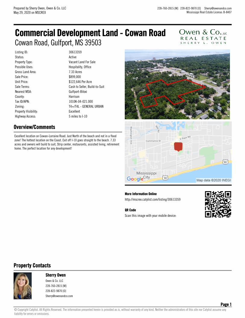
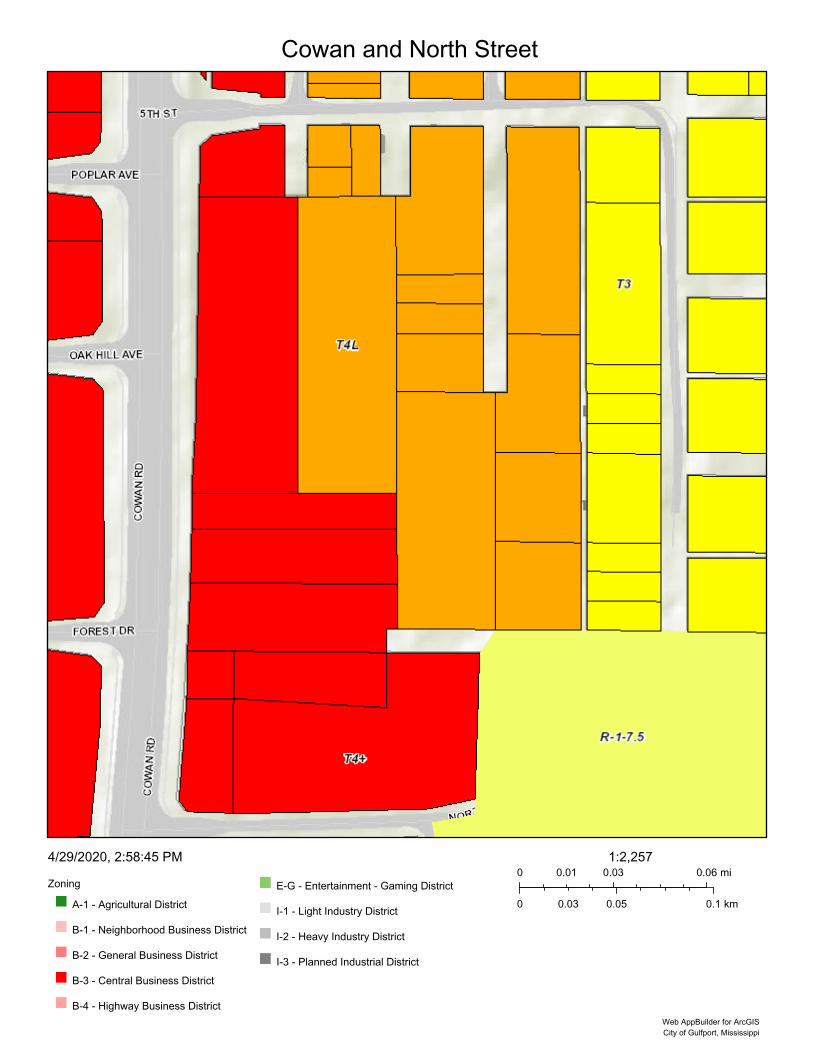
Listing ID: 30613359Status: ActiveProperty Type: Vacant Land For SalePossible Uses: Hospitality, OfficeGross Land Area: 7.33 AcresSale Price: $899,000Unit Price: $122,646 Per AcreSale Terms: Cash to Seller, Build-to-SuitNearest MSA: Gulfport-BiloxiCounty: HarrisonTax ID/APN: 1010K-04-021.000Zoning: T4+/T4L - GENERAL URBANProperty Visibility: ExcellentHighway Access: 5 miles to I-10
Overview/CommentsOverview/CommentsExcellent location on Cowan-Lorraine Road. Just North of the beach and not in a floodzone! The hottest location on the Coast. Exit off I-10 goes straight to the beach. 7.33acres and owners will build to suit, Strip center, restaurants, assisted living, retirementhome. The perfect location for any development!
Commercial Development Land - Cowan RoadCommercial Development Land - Cowan RoadCowan Road, Gulfport, MS 39503
40' RIGHT-OF-WAY AS PER HARRISON COUNTY TAX MAP (UNIMPROVED SURFACE)
AutoCAD SHX Text
DEED INSTRUMENT NUMBER 2014-0009229-D-J1.
AutoCAD SHX Text
NOW OR FORMERLY COLUMBUS MANAGEMENT LLC PROPERTY
AutoCAD SHX Text
TAX PARCEL NUMBER: 1010K-04-010.000
AutoCAD SHX Text
40' RIGHT-OF-WAY AS PER HARRISON COUNTY TAX MAP (SOUTHERN END HAS AN UNIMPROVED SURFACE)
AutoCAD SHX Text
10' ALLEY AS PER HARRISON COUNTY TAX MAP (UNIMPROVED SURFACE) (PLATTED 10')
AutoCAD SHX Text
TAX PARCEL NUMBER: 1010K-04-009.000
AutoCAD SHX Text
TAX PARCEL NUMBER: 1010K-04-008.000
AutoCAD SHX Text
TAX PARCEL NUMBER: 1010K-04-007.000
AutoCAD SHX Text
TAX PARCEL NUMBER: 1010K-04-006.000
AutoCAD SHX Text
TAX PARCEL NUMBER: 1010K-04-006.000
AutoCAD SHX Text
TAX PARCEL NUMBER: 1010K-04-006.001
AutoCAD SHX Text
TAX PARCEL NUMBER: 1010K-04-011.000
AutoCAD SHX Text
TAX PARCEL NUMBER: 1010K-04-005.000
AutoCAD SHX Text
35' PLATTED RIGHT-OF-WAY AS PER EUREKA ADDITION SUBDIVISION. THIS ROAD NAME IS ILLEGIBLE ON THE RECORDED PLAT AND IS SHOWN AS NORTH STREET ON HARRISON COUNTY TAX MAPS. THIS RIGHT-0F-WAY IS WOODED AND UNIMPROVED AT THE TIME OF SURVEY. NO DOCUMENTATION WAS FOUND OR FURNISHED SHOWING THAT THIS STREET HAS BEEN VACATED.
AutoCAD SHX Text
DEED INSTRUMENT NUMBER 2014-0009229-D-J1.
AutoCAD SHX Text
NOW OR FORMERLY COLUMBUS MANAGEMENT LLC PROPERTY
AutoCAD SHX Text
DEED INSTRUMENT NUMBER 2014-0009229-D-J1.
AutoCAD SHX Text
DEED INST# 2014-0009229-D-J1.
AutoCAD SHX Text
N/F COLUMBUS MANAGEMENT LLC PROPERTY
AutoCAD SHX Text
DEED INST. No. 2014-0009229-D-J1.
AutoCAD SHX Text
NOW OR FORMERLY COLUMBUS MANAGEMENT LLC PROPERTY
AutoCAD SHX Text
40' RIGHT-OF-WAY AS PER HARRISON COUNTY TAX MAP (UNIMPROVED SURFACE)
AutoCAD SHX Text
PLATTED 47.8' RIGHT-OF-WAY AS PER RECORDED PLAT (PLATTED AS HARMONSON AVENUE)
AutoCAD SHX Text
VACATED IN CHANCERY COURT CAUSE # 58,404; DATED MARCH 10, 1970, RECORDED IN MB 221 AT PAGE 195/198 AND DB 643 AT PAGE 134/138.
AutoCAD SHX Text
DEED BOOK 643 AT PAGE 76.
AutoCAD SHX Text
NOW OR FORMERLY GULF SOUTH CAPITAL CORP PROPERTY
AutoCAD SHX Text
TAX PARCEL NUMBER: 1010K-04-017.000
AutoCAD SHX Text
NOW OR FORMERLY BABIN PROPERTY
AutoCAD SHX Text
TAX PARCEL NUMBER: 1010K-04-016.000
AutoCAD SHX Text
DEED INSTRUMENT NUMBER 2012-0006277-D-J1.
AutoCAD SHX Text
NOW OR FORMERLY MOSEBAY PROPERTY
AutoCAD SHX Text
TAX PARCEL NUMBER: 1010K-04-012.000
AutoCAD SHX Text
DEED INSTRUMENT NUMBER 2017-0000119-D-J1.
AutoCAD SHX Text
TAX PARCEL NUMBER: 1010K-04-002.000
AutoCAD SHX Text
DEED INSTRUMENT NUMBER 2016-0000971-D-J1.
AutoCAD SHX Text
TAX PARCEL NUMBER: 1010K-04-003.000
AutoCAD SHX Text
DEED BK. 1143 AT PG. 632.
AutoCAD SHX Text
NOW OR FORMERLY PARKER PROPERTY
AutoCAD SHX Text
TAX PARCEL NUMBER: 1010K-04-004.000
AutoCAD SHX Text
DEED BK. 1321 AT PG. 677.
AutoCAD SHX Text
DEED INST. No. 2005-0013993-D-J1.
AutoCAD SHX Text
NOW OR FORMERLY CORNELSON PROPERTY
AutoCAD SHX Text
PLAT=125'
AutoCAD SHX Text
PLAT=125'
AutoCAD SHX Text
P=25'
AutoCAD SHX Text
PLAT=500'
AutoCAD SHX Text
P=25'
AutoCAD SHX Text
P=25'
AutoCAD SHX Text
PLAT=125'
AutoCAD SHX Text
N81°00'44"W 69.83'
AutoCAD SHX Text
S88°25'04"W 88.41'
AutoCAD SHX Text
1/2" IRON ROD FOUND
AutoCAD SHX Text
L=194.15', R=5351.05' CH=N02°55'38"E 194.13'
AutoCAD SHX Text
N87°04'24"W 100.02'
AutoCAD SHX Text
S89°53'08"W 83.58'
AutoCAD SHX Text
PS=S89°26'42"W 83.58'
AutoCAD SHX Text
PS=S87°31'58"W 88.35'
AutoCAD SHX Text
PS=N81°39'11"W 69.83'
AutoCAD SHX Text
PS=N87°43'19"W 100.12'
AutoCAD SHX Text
PS=N01°05'37"W 76.17'
AutoCAD SHX Text
PS=S01°10'42"E 129.40'
AutoCAD SHX Text
D=S87°32'48"W 88.43'
AutoCAD SHX Text
D=N81°31'20"W 69.85'
AutoCAD SHX Text
D=N87°37'52"W 100.00'
AutoCAD SHX Text
DEED OVERALL= S89°32'21"W 170.59'
AutoCAD SHX Text
1/2" IRON ROD FOUND
AutoCAD SHX Text
3/4" IRON PIPE FOUND AT T-BAR
AutoCAD SHX Text
1/2" IRON ROD FOUND
AutoCAD SHX Text
1/2" IRON ROD FOUND
AutoCAD SHX Text
1/2" IRON ROD FOUND
AutoCAD SHX Text
1/2" IRF
AutoCAD SHX Text
1/2" IRON ROD FOUND
AutoCAD SHX Text
D=L=194.05', R=5351.05' CH=N02°55'30"E 194.05'
AutoCAD SHX Text
DEED BOOK 1279, PAGE 226
AutoCAD SHX Text
NOW OR FORMERLY LACUESTA PROPERTY
AutoCAD SHX Text
NOW OR FORMERLY YOUNG PROPERTY
AutoCAD SHX Text
S00°30'26"E 92.55'
AutoCAD SHX Text
S00°30'26"E 36.78'
AutoCAD SHX Text
D=S01°04'45"E 92.55'
AutoCAD SHX Text
S89°41'16"E 329.17'
AutoCAD SHX Text
PS=N89°40'12"E 329.16'
AutoCAD SHX Text
D=N89°43'24"E 431.20'
AutoCAD SHX Text
PS=L=194.29', R=5351.85' CH=N02°16'29"E 194.28'
AutoCAD SHX Text
PLATTED 38.8' RIGHT-OF-WAY COLLECTIVELY FROM PLAT OF EUREKA ADDITION (23.8') AND THE PLAT OF ABYSSINIA SUBDIVISION (15.0')
AutoCAD SHX Text
50' RIGHT-OF-WAY PER HARRISON COUNTY TAX MAPS
AutoCAD SHX Text
10' ALLEY AS PER HARRISON COUNTY TAX MAP (UNIMPROVED SURFACE) (PLATTED 10') (VACATED)
AutoCAD SHX Text
47' RIGHT-OF-WAY PER PLAT AND HARRISON COUNTY TAX MAPS
AutoCAD SHX Text
40' RIGHT-OF-WAY PER PLAT AND HARRISON COUNTY TAX MAPS
AutoCAD SHX Text
N00°19'55"E 88.93'
AutoCAD SHX Text
N47°47'12"E 27.07'
AutoCAD SHX Text
N81°12'01"E 83.04'
AutoCAD SHX Text
N04°13'36"W 5.67'
AutoCAD SHX Text
N89°52'24"E 42.04'
AutoCAD SHX Text
S89°34'26"E 366.38'
AutoCAD SHX Text
S00°09'19"E 125.07'
AutoCAD SHX Text
NOW OR FORMERLY GULF SOUTH CAPITAL CORP PROPERTY
AutoCAD SHX Text
TAX PARCEL NUMBER: 1010K-04-025.000
AutoCAD SHX Text
DEED BOOK 643 AT PAGE 79
AutoCAD SHX Text
NOW OR FORMERLY BELLWETHER LLC PROPERTY
AutoCAD SHX Text
TAX PARCEL NUMBER: 1010K-04-024.000
AutoCAD SHX Text
DEED INSTRUMENT NUMBER 2014-0003866-D-J1.
AutoCAD SHX Text
NOW OR FORMERLY MCQUEEN ESTATE PROPERTY
AutoCAD SHX Text
TAX PARCEL NUMBER: 1010K-04-023.001
AutoCAD SHX Text
DB 717 / PG 520
AutoCAD SHX Text
NOW OR FORMERLY COLE PROPERTY
AutoCAD SHX Text
TAX PARCEL NUMBER: 1010K-04-022.000
AutoCAD SHX Text
DEED BOOK 693 AT PAGE 314
AutoCAD SHX Text
NOW OR FORMERLY OWENS PROPERTY
AutoCAD SHX Text
TAX PARCEL NUMBER: 1010K-04-013.000
AutoCAD SHX Text
DEED INSTRUMENT NUMBER 2016-0003511-D-J1.
AutoCAD SHX Text
NOW OR FORMERLY MOORE PROPERTY
AutoCAD SHX Text
TAX PARCEL NUMBER: 1010K-04-014.000
AutoCAD SHX Text
DEED INST.# 2012-0004660-D-J1.
AutoCAD SHX Text
NOW OR FORMERLY PARSONS PROPERTY
AutoCAD SHX Text
TAX PARCEL NUMBER: 1010K-04-015.000
AutoCAD SHX Text
DEED BOOK 604 AT PAGE 100
AutoCAD SHX Text
NOW OR FORMERLY GULF SOUTH CAPITAL CORP PROPERTY
AutoCAD SHX Text
TAX PARCEL NUMBER: 1010K-04-021.000
AutoCAD SHX Text
DEED BOOK 643 AT PAGE 76
AutoCAD SHX Text
LOT 25
AutoCAD SHX Text
LOT 24
AutoCAD SHX Text
LOT 23
AutoCAD SHX Text
LOT 22
AutoCAD SHX Text
LOT 21
AutoCAD SHX Text
LOT 20
AutoCAD SHX Text
LOT 19
AutoCAD SHX Text
LOT 18
AutoCAD SHX Text
LOT 17
AutoCAD SHX Text
LOT 16
AutoCAD SHX Text
LOT 15
AutoCAD SHX Text
LOT 14
AutoCAD SHX Text
LOT 13
AutoCAD SHX Text
LOT 12
AutoCAD SHX Text
LOT 11
AutoCAD SHX Text
LOT 10
AutoCAD SHX Text
LOT 9
AutoCAD SHX Text
LOT 8
AutoCAD SHX Text
LOT 7
AutoCAD SHX Text
LOT 6
AutoCAD SHX Text
LOT 5
AutoCAD SHX Text
LOT 4
AutoCAD SHX Text
LOT 3
AutoCAD SHX Text
LOT 2
AutoCAD SHX Text
VACATED IN CHANCERY COURT CAUSE # 58,404; DATED MARCH 10, 1970, RECORDED IN MB 221 AT PAGE 195/198 AND DB 643 AT PAGE 134/138.
AutoCAD SHX Text
VACATED IN CITY OF GULFPORT ORDINANCE #1760; DATED DECEMBER 16, 1986, RECORDED IN MB 168 AT PAGE 520 AND DB 1069 AT PAGE 145. (AS HAND WRITTEN ON THE FACE OF THE RECORDED SUBDIVISION PLAT)
AutoCAD SHX Text
VACATED IN CHANCERY COURT CAUSE # 58,404; DATED MARCH 10, 1970, RECORDED IN MB 221 AT PAGE 195/198 AND DB 643 AT PAGE 134/138.
AutoCAD SHX Text
VACATED IN CHANCERY COURT CAUSE # 58,404; DATED MARCH 10, 1970, RECORDED IN MB 221 AT PAGE 195/198 AND DB 643 AT PAGE 134/138.
VACATED IN CHANCERY COURT CAUSE # 58,404; DATED MARCH 10, 1970, RECORDED IN MB 221 AT PAGE 195/198 AND DB 643 AT PAGE 134/138.
AutoCAD SHX Text
PLAT=125'
AutoCAD SHX Text
S00°13'07"W 400.41'
AutoCAD SHX Text
S00°09'02"W 349.44'
AutoCAD SHX Text
1/2" IRON ROD FOUND
AutoCAD SHX Text
PUBLIC RIGHT-OF-WAY (VARIES IN WIDTH) (ASPHALT SURFACE)
AutoCAD SHX Text
N00°11'37"E 224.76'
AutoCAD SHX Text
N00°13'29"E 175.15'
AutoCAD SHX Text
PLAT=225'
AutoCAD SHX Text
PLAT=175'
AutoCAD SHX Text
DEED=EAST 164.4'
AutoCAD SHX Text
DEED=SOUTH 325'
AutoCAD SHX Text
DEED=EAST 164.4'
AutoCAD SHX Text
S89°58'01"E 164.44'
AutoCAD SHX Text
PLAT=SOUTH 400'
AutoCAD SHX Text
DEED=WEST 168.4'
AutoCAD SHX Text
CONCRETE MONUMENT FOUND
AutoCAD SHX Text
CONCRETE MONUMENT FOUND
AutoCAD SHX Text
156.78'
AutoCAD SHX Text
171.21'
AutoCAD SHX Text
1/2" IRON ROD FOUND AT T-BAR
AutoCAD SHX Text
CAPPED 1/2" IRON ROD SET
AutoCAD SHX Text
1/2" IRON ROD FOUND
AutoCAD SHX Text
1/2" IRON ROD FOUND AT T-BAR
AutoCAD SHX Text
S89°44'06"W 168.44
AutoCAD SHX Text
CAPPED 1/2" IRON ROD SET
AutoCAD SHX Text
NOW OR FORMERLY COLUMBUS MANAGEMENT LLC PROPERTY
AutoCAD SHX Text
CHAIN LINK FENCE POST IS 0.4'± NORTH AND 0.4'± WESTOF PROPERTY CORNER
AutoCAD SHX Text
CHAIN LINK FENCE LINE
AutoCAD SHX Text
CHAIN LINK FENCE POST IS 0.3'± NORTH AND 0.4'± EASTOF PROPERTY CORNER
AutoCAD SHX Text
PLAT=350'
AutoCAD SHX Text
P=25'
AutoCAD SHX Text
P=25'
AutoCAD SHX Text
PLAT=125'
AutoCAD SHX Text
N00°08'06"E 226.03'
AutoCAD SHX Text
(OVERALL) DEED=NORTH 225'
AutoCAD SHX Text
3/4" IRON PIPE FOUND AT PROPERTY CORNER (BENT)
AutoCAD SHX Text
3/4" IRON PIPE FOUND 2.6'± SOUTH OF LINE(BENT)
AutoCAD SHX Text
3/4" IRON PIPE FOUND (BENT)
AutoCAD SHX Text
1" IRON PIPE FOUND IS 3.7'± SOUTH AND 4.4'±EAST OF PROPERTY CORNER (BENT)
AutoCAD SHX Text
3/4" IRON PIPE FOUND (BENT)
AutoCAD SHX Text
1/2" IRON ROD FOUND IS NORTH 0.27' AND WEST 1.54' OF PROPERTY CORNER
AutoCAD SHX Text
TRACES OF WIRE FENCE LINE ON PROPERTY LINE
AutoCAD SHX Text
END OF WIRE FENCE LINE IS 0.9'± EAST OF PROPERTY LINE
AutoCAD SHX Text
4"x6" WOOD POST IS 0.9'±EAST OF PROPERTY CORNER
AutoCAD SHX Text
TRACES OF WIRE FENCE LINE
AutoCAD SHX Text
3/4" IPF
AutoCAD SHX Text
3/4" IPF
AutoCAD SHX Text
3/4" IPF
AutoCAD SHX Text
3/4" IRON PIPE FOUND
AutoCAD SHX Text
1/2" IRON ROD FOUND (P.O.L.)
AutoCAD SHX Text
CHAIN LINK FENCE LINE
AutoCAD SHX Text
PLAT=15'
AutoCAD SHX Text
PLAT=23.8'
AutoCAD SHX Text
PLAT=23.8'
AutoCAD SHX Text
N89°50'36"E 23.79
AutoCAD SHX Text
PRIOR SURVEY BY FLOYD HOVAS DATED MARCH 27, 1974.
AutoCAD SHX Text
PLAT=125'
AutoCAD SHX Text
PLAT=135'
AutoCAD SHX Text
PLAT=135'
AutoCAD SHX Text
N89°32'42"E 127.15
AutoCAD SHX Text
N00°16'37"W 49.88'
AutoCAD SHX Text
S00°09'07"E 50.14'
AutoCAD SHX Text
CAPPED 1/2" IRON ROD SET
AutoCAD SHX Text
ASPHALT SURFACE PUBLIC ROADWAY
AutoCAD SHX Text
NOW OR FORMERLY GULF STATES CONFERENCE ASSOCIATION PROPERTY
AutoCAD SHX Text
PLAT=149.65'
AutoCAD SHX Text
PLAT=156.03'
AutoCAD SHX Text
PLAT=75'
AutoCAD SHX Text
PLAT=75'
AutoCAD SHX Text
PLAT=75'
AutoCAD SHX Text
PLAT=75'
AutoCAD SHX Text
PLAT=75'
AutoCAD SHX Text
PLAT=75'
AutoCAD SHX Text
PLAT=102'
AutoCAD SHX Text
PLAT=75'
AutoCAD SHX Text
PLAT=75'
AutoCAD SHX Text
PLAT=75'
AutoCAD SHX Text
PLAT=75'
AutoCAD SHX Text
PLAT=75'
AutoCAD SHX Text
PLAT=75'
AutoCAD SHX Text
PLAT=102'
AutoCAD SHX Text
PLAT=75'
AutoCAD SHX Text
PLAT=75'
AutoCAD SHX Text
PLAT=150.41'
AutoCAD SHX Text
PLAT=151.18'
AutoCAD SHX Text
PLAT=151.94'
AutoCAD SHX Text
PLAT=152.70'
AutoCAD SHX Text
PLAT=153.47'
AutoCAD SHX Text
PLAT=154.23'
AutoCAD SHX Text
PLAT=155.27'
AutoCAD SHX Text
50' RIGHT-OF-WAY AS PER RECODED PLAT OF LAKE FOREST SUBDIVISION
AutoCAD SHX Text
PLAT=148.89'
AutoCAD SHX Text
20' DRAINAGE AND UTILITY EASEMENT
AutoCAD SHX Text
N00°35'28"E
AutoCAD SHX Text
225.00'
AutoCAD SHX Text
10' DRAINAGE AND UTILITY EASEMENT
AutoCAD SHX Text
3/4" IRON PIPE FOUND
AutoCAD SHX Text
3/4" IRON PIPE FOUND
AutoCAD SHX Text
PLAT=225'
AutoCAD SHX Text
PLAT=75'
AutoCAD SHX Text
PLAT=75'
AutoCAD SHX Text
PLAT=75'
AutoCAD SHX Text
PLAT=75'
AutoCAD SHX Text
PLAT=169'
AutoCAD SHX Text
PLAT=50'
AutoCAD SHX Text
1" IRON ROD FOUND (BENT)
AutoCAD SHX Text
40' RIGHT-OF-WAY AS PER PLAT AND HARRISON COUNTY TAX MAP (UNIMPROVED SURFACE)
AutoCAD SHX Text
40' RIGHT-OF-WAY AS PER PLAT AND HARRISON COUNTY TAX MAP (UNIMPROVED SURFACE)
AutoCAD SHX Text
PLAT=125'
AutoCAD SHX Text
P=25'
AutoCAD SHX Text
PLAT=125'
AutoCAD SHX Text
P=25'
AutoCAD SHX Text
PLAT=125'
AutoCAD SHX Text
P=25'
AutoCAD SHX Text
PLAT=125'
AutoCAD SHX Text
P=25'
AutoCAD SHX Text
PLAT=200'
AutoCAD SHX Text
UNIT 2
AutoCAD SHX Text
UNIT 1
AutoCAD SHX Text
NOW OR FORMERLY DOLLAR GENERAL PROPERTY
AutoCAD SHX Text
PLAT=40'
AutoCAD SHX Text
P=25'
AutoCAD SHX Text
1" IRON PIPE FOUND (BENT)
AutoCAD SHX Text
P=10'
AutoCAD SHX Text
PLAT=135'
AutoCAD SHX Text
TAX DIVISION LINE (TYPICAL)
AutoCAD SHX Text
TAX DIVISION LINE (TYPICAL)
AutoCAD SHX Text
10.4'
AutoCAD SHX Text
P=10'
AutoCAD SHX Text
S00°03'44"W 199.82'
AutoCAD SHX Text
PLAT=200'
AutoCAD SHX Text
PLAT=150'
AutoCAD SHX Text
PLAT=150'
AutoCAD SHX Text
PLAT=125'
AutoCAD SHX Text
S87°51'29"E 10.43'
AutoCAD SHX Text
CAPPED 1/2" IRON ROD SET
AutoCAD SHX Text
1" IPF AT PROPERTY CORNER
AutoCAD SHX Text
PLAT=23.8'
AutoCAD SHX Text
PLAT=23.8'
AutoCAD SHX Text
CAPPED 1/2" IRON ROD SET
AutoCAD SHX Text
END OF WIRE FENCE LINE IS 0.9'± EAST OFPROPERTY LINE
AutoCAD SHX Text
PLAT=47.8'
AutoCAD SHX Text
PLAT=47.8'
AutoCAD SHX Text
P=10'
AutoCAD SHX Text
CHAIN LINK FENCE LINE
AutoCAD SHX Text
CAPPED 1/2" IRON ROD SET
AutoCAD SHX Text
PLAT=150'
AutoCAD SHX Text
DEED INST# 2016-0004794-D-J1.
AutoCAD SHX Text
N/F BABIN PROPERTY
AutoCAD SHX Text
DEED INST# 2015-0008937-D-J1.
AutoCAD SHX Text
N/F PRESS PROPERTY
AutoCAD SHX Text
DEED BK. 1602 PG. 622
AutoCAD SHX Text
N/F WEBSTER PROPERTY
AutoCAD SHX Text
S89°33'30"E 108.35'
AutoCAD SHX Text
PRIOR SURVEY BY PATRICK M. MARTINO, DATED JUNE 21, 2016.
AutoCAD SHX Text
3/4" IRON PIPE FOUND
AutoCAD SHX Text
PLAT=125'
AutoCAD SHX Text
PLAT=50'
AutoCAD SHX Text
PLAT=50'
AutoCAD SHX Text
PLAT=10'
AutoCAD SHX Text
EAST MARGIN OF RIGHT-OF-WAY
AutoCAD SHX Text
CHRD=N00°52'38"E 149.98'
AutoCAD SHX Text
D=90.4'
AutoCAD SHX Text
D=60'
AutoCAD SHX Text
50
AutoCAD SHX Text
0
AutoCAD SHX Text
50
AutoCAD SHX Text
100
AutoCAD SHX Text
150
AutoCAD SHX Text
GRAPHIC SCALE - FEET
AutoCAD SHX Text
NO FLOOD ZONE DETERMINATION WAS PERFORMED AS A PART OF THIS SURVEY. AN ACCURATE DETERMINATION CAN BE MADE BY ORDERING A FEMA ELEVATION CERTIFICATE.
AutoCAD SHX Text
U
AutoCAD SHX Text
P.L.S. 2838
AutoCAD SHX Text
M
AutoCAD SHX Text
S
AutoCAD SHX Text
M
AutoCAD SHX Text
S
AutoCAD SHX Text
O
AutoCAD SHX Text
D
AutoCAD SHX Text
F
AutoCAD SHX Text
P
AutoCAD SHX Text
C
AutoCAD SHX Text
R
AutoCAD SHX Text
L
AutoCAD SHX Text
I
AutoCAD SHX Text
N
AutoCAD SHX Text
A
AutoCAD SHX Text
E
AutoCAD SHX Text
F
AutoCAD SHX Text
O
AutoCAD SHX Text
K
AutoCAD SHX Text
A
AutoCAD SHX Text
P
AutoCAD SHX Text
T
AutoCAD SHX Text
S
AutoCAD SHX Text
T
AutoCAD SHX Text
A
AutoCAD SHX Text
R
AutoCAD SHX Text
E
AutoCAD SHX Text
T
AutoCAD SHX Text
R
AutoCAD SHX Text
V
AutoCAD SHX Text
S
AutoCAD SHX Text
O
AutoCAD SHX Text
N
AutoCAD SHX Text
P
AutoCAD SHX Text
T
AutoCAD SHX Text
I
AutoCAD SHX Text
I
AutoCAD SHX Text
S
AutoCAD SHX Text
P
AutoCAD SHX Text
Y
AutoCAD SHX Text
O
AutoCAD SHX Text
S
AutoCAD SHX Text
E
AutoCAD SHX Text
I
AutoCAD SHX Text
S
AutoCAD SHX Text
N
AutoCAD SHX Text
S
AutoCAD SHX Text
I
AutoCAD SHX Text
O
AutoCAD SHX Text
M
AutoCAD SHX Text
.
AutoCAD SHX Text
I
AutoCAD SHX Text
I
AutoCAD SHX Text
A
AutoCAD SHX Text
A
AutoCAD SHX Text
L
AutoCAD SHX Text
R
AutoCAD SHX Text
R
AutoCAD SHX Text
1/25/2018
AutoCAD SHX Text
P18042
AutoCAD SHX Text
-- (CMS) CONCRETE MONUMENT SET
AutoCAD SHX Text
-- (CMF) CONCRETE MONUMENT FOUND
AutoCAD SHX Text
-- (IRS) IRON ROD SET
AutoCAD SHX Text
-- (IPF) IRON PIPE FOUND
AutoCAD SHX Text
-- (IRF) IRON ROD FOUND
AutoCAD SHX Text
1.) HARRISON COUNTY GIS WEBSITE AND TAX MAP, CURRENT EDITION. 2.) SPECIAL WARRANTY DEED INSTRUMENT NUMBER 2014-0009229-D-J1. 3.) WARRANTY DEED BOOK 714 AT PAGE 524. 4.) WARRANTY DEED BOOK 643 AT PAGE 76. 5.) WARRANTY DEED BOOK 1427 AT PAGE 429. 6.) FINAL DECREE BOOK 643 AT PAGE 134. 7.) WARRANTY DEED INSTRUMENT NUMBER 2008-0001171-D-J1. 8.) WARRANTY DEED INSTRUMENT NUMBER 2008-0001169-D-J1. 9.) PLAT OF ABYSSINIA SUBDIVISION, RECORDED IN COPY BOOK 3 AT PAGE 219. 10.) PLAT OF EUREKA ADDITION SUBDIVISION, RECORDED IN COPY BOOK 4 AT PAGE 279. 11.) PLAT OF LAKE FOREST SUBDIVISION UNIT ONE, RECORDED IN PLAT BOOK 21 AT PAGE 23. 12.) PLAT OF LAKE FOREST SUBDIVISION UNITY TWO, RECORDED IN PLAT BOOK 21 AT PAGE 29. 13.) PRIOR SURVEY PERFORMED BY FLOYD HOVAS, DATED MARCH 27, 1974.
AutoCAD SHX Text
LOTS TWENTY-THREE TO TWENTY-EIGHT (23-28) INCLUSIVE, THIRTY-FIVE TO FIFTY-FOUR (35-54) INCLUSIVE, BLOCK SIX (EUREKA ADDITION TO THE CITY OF GULFPORT, ACCORDING TO THE OFFICIAL MAP OR PLAT THEREOF; ON FILE AND OF RECORD IN THE OFFICE OF THE CHANCERY CLERK OF THE FIRST JUDICIAL DISTRICT OF HARRISON COUNTY, MISSISSIPPI IN PLAT BOOK 9 AT PAGE 8 (COPY BOOK 4 AT PAGE 279) THEREOF; REFERENCE TO WHICH IS HEREBY MADE IN AID OF AND AS PART OF THIS DESCRIPTION.
AutoCAD SHX Text
DEED = DEED DIMENSION PRIOR = PRIOR SURVEY PLAT = PLATTED DIMENSION C/L = CENTERLINE P.O.B. = POINT OF BEGINNING P.O.C. = POINT OF COMMENCEMENT P.O.L. = POINT ON LINE R.O.W. = RIGHT-OF-WAY N90°00'00"E 435.00' = ACTUAL FIELD MEASUREMENT
AutoCAD SHX Text
DATE OF FIELD SURVEY
AutoCAD SHX Text
1/24/2018
AutoCAD SHX Text
PATRICK M. MARTINO
AutoCAD SHX Text
THIS IS TO CERTIFY THAT I HAVE MADE A SURVEY OF THE PROPERTY SHOWN HEREON AND THAT ALL DIMENSIONS AND OTHER DATA SHOWN ARE TRUE AND CORRECT TO THE BEST OF MY KNOWLEDGE AND BELIEF.
AutoCAD SHX Text
BOUNDARY SURVEYS ARE BASED UPON THE RECORDED SUBDIVISION PLAT IN CASES OF REGULAR SUBDIVISIONS LOTS. BOUNDARY SURVEYS OF PROPERTIES NOT A PART OF A REGULAR SUBDIVISION ARE BASED UPON TITLE INFORMATION PROVIDED BY THE PARTY REQUESTING THE SURVEY. BOUNDARY SURVEY PLATS REFLECT INFORMATION DISCOVERED BY THE SURVEYOR IN THE NORMAL COURSE OF WORK AND DOES NOT NECESSARILY SHOW EVERY POSSIBLE CONDITION AFFECTING THE PROPERTY. EASEMENTS, SERVITUDES, BUILDING ORDINANCES, ZONING, AND OTHER LEGAL ENCUMBERMENTS MAY EXIST. CONSULT A TITLE ATTORNEY IF YOU WISH TO DISCOVER ALL THE LEGAL ENCUMBERMENTS ATTACHED TO ANY PROPERTY.
AutoCAD SHX Text
P
AutoCAD SHX Text
A
AutoCAD SHX Text
T
AutoCAD SHX Text
R
AutoCAD SHX Text
I
AutoCAD SHX Text
C
AutoCAD SHX Text
K
AutoCAD SHX Text
M
AutoCAD SHX Text
.
AutoCAD SHX Text
M
AutoCAD SHX Text
A
AutoCAD SHX Text
R
AutoCAD SHX Text
T
AutoCAD SHX Text
I
AutoCAD SHX Text
N
AutoCAD SHX Text
O
AutoCAD SHX Text
P
AutoCAD SHX Text
R
AutoCAD SHX Text
O
AutoCAD SHX Text
F
AutoCAD SHX Text
E
AutoCAD SHX Text
S
AutoCAD SHX Text
S
AutoCAD SHX Text
I
AutoCAD SHX Text
O
AutoCAD SHX Text
N
AutoCAD SHX Text
A
AutoCAD SHX Text
L
AutoCAD SHX Text
L
AutoCAD SHX Text
A
AutoCAD SHX Text
N
AutoCAD SHX Text
D
AutoCAD SHX Text
S
AutoCAD SHX Text
U
AutoCAD SHX Text
R
AutoCAD SHX Text
V
AutoCAD SHX Text
E
AutoCAD SHX Text
Y
AutoCAD SHX Text
O
AutoCAD SHX Text
R
AutoCAD SHX Text
-- (FCP) FENCE CORNER POST
AutoCAD SHX Text
1.) THIS SURVEY AND PLAT WERE PREPARED ONLY FOR THE CLIENT NAMED HEREON AND NO THIRD PARTY CERTIFICATION IS EXPRESSED OR IMPLIED. 2.) A COPY OF THIS PLAT IS VALID ONLY IF IT IS COMPLETE AND INTACT, HAS AN ORIGINAL SIGNATURE AND DATE, AND HAS THE ORIGINAL EMBOSSED OR COLORED (NOT BLACK) STAMPED SURVEYOR'S SEAL. 3.) THIS SURVEY IS SUBJECT TO ALL APPLICABLE GOVERNMENTAL REGULATIONS, BUILDING OR OTHER RESTRICTIONS, LEGAL RESTRICTIONS OF ANY NATURE AND FURTHER SUBJECT TO ANY AND ALL EASEMENTS, RESTRICTIVE COVENANTS, AND RIGHTS-OF-WAY OF RECORD. 4.) REDIVISION OF THIS PROPERTY IS SUBJECT TO CURRENT SUBDIVISION AND ZONING REGULATIONS AND ET CETERA. APPROVAL NEEDS TO BE OBTAINED FROM THE APPROPRIATE GOVERNING BODIES.
GEODETIC NORTH BY GPS OBSERVATION; ALL LINES RELATIVE TO.
AutoCAD SHX Text
BEARINGS SHOWN HEREON ARE DERIVED BY:
AutoCAD SHX Text
SCALE: 1"=50'
AutoCAD SHX Text
SURVEY CLASS "B"
AutoCAD SHX Text
THIS SURVEY WAS PREPARED FROM INFORMATION PROVIDED BY CLIENT, WITHOUT THE BENEFIT OF A CURRENT TITLE REPORT OR AN ENVIRONMENTAL STUDY.
AutoCAD SHX Text
CLIENT:
AutoCAD SHX Text
REVISED:
AutoCAD SHX Text
PMM, PTPD
AutoCAD SHX Text
PMM, BF
AutoCAD SHX Text
DATE:
AutoCAD SHX Text
JOB#:
AutoCAD SHX Text
DRAWN BY:
AutoCAD SHX Text
CREW CHIEF:
AutoCAD SHX Text
PARCEL ADDRESS:
AutoCAD SHX Text
OLD JOB#:
AutoCAD SHX Text
LOTS 6 AND 7 AND LOTS 10 THROUGH 13, INCLUSIVE, BLOCK 4 ABYSSINIA SUBDIVISION, A SUBDIVISION ACCORDING TO A MAP OR PLAT THEREOF ON FILE AND OF RECORD IN PLAT BOOK 7 AT PAGE 4, IN THE OFFICE OF THE CHANCERY CLERK OF HARRISON COUNTY, MISSISSIPPI.
AutoCAD SHX Text
LOTS 8 AND 9, LOTS 14 THROUGH 25, INCLUSIVE, LOTS 41 THROUGH 50, INCLUSIVE, BLOCK 4; AND LOTS 6 THROUGH 25, INCLUSIVE, OF BLOCK 3; ABYSSINIA SUBDIVISION, ACCORDING TO A MAP OR PLAT THEREOF ON FILE AND OF RECORD IN THE OFFICE OF THE CHANCERY CLERK OF HARRISON COUNTY, MISSISSIPPI. AND ALSO: LOTS 19 THROUGH 34, INCLUSIVE, OF BLOCK 7, EUREKA SUBDIVISION, ACCORDING TO THE OFFICIAL MAP OF PLAT THEREOF ON FILE AND OF RECORD IN THE OFFICE OF THE CHANCERY CLERK OF HARRISON COUNTY, MISSISSIPPI; TOGETHER WITH ALL INTEREST THE GRANTORS NOW HAVE OR MAY HEREINAFTER ACQUIRE IN THE STREETS AND ALLEYS JOINING THE ABOVE DESCRIBED LAND AND PROPERTY.
AutoCAD SHX Text
LOTS 31 - 40 INCLUSIVE OF BLOCK 4, ABYSSINIA SUBDIVISION, A SUBDIVISION LOCATED IN THE CITY OF GULFPORT, FIRST JUDICIAL DISTRICT OF HARRISON COUNTY, MISSISSIPPI, ACCORDING TO THE OFFICIAL MAP OR PLAT THEREOF ON FILE AND OF RECORD IN THE OFFICE OF THE CHANCERY CLERK IN PLAT BOOK 7 AT PAGE 4, AND ALSO: BEGINNING AT THE NORTHEAST CORNER OF LOT 6, BLOCK 4 OF ABYSSINIA SUBDIVISION AND FROM SAID POINT RUN THENCE SOUTH TO THE SOUTHEAST CORNER OF LOT 25, FROM SAID POINT RUN THENCE EAST 10 FEET TO THE SOUTHWEST CORNER OF LOT 50, FROM SAID POINT RUN THENCE NORTH TO THE NORTHWEST CORNER OF LOT 31, FROM SAID POINT RUN THENCE WEST A DISTANCE OF 10 FEET TO THE POINT OF BEGINNING. SAID PROPERTY BEING LOCATED IN THE FIRST JUDICIAL DISTRICT OF HARRISON COUNTY, MISSISSIPPI.
AutoCAD SHX Text
SURVEYOR NOTE: : THE RECORDED SUBDIVISION PLAT OF EUREKA SUBDIVISION, BEING RECORDED IN PLAT COPY BOOK 4, AT PAGE 279, SHOWS A 10 FOOT ALLEY RUNNING THROUGH THE CENTER OF BLOCK 6. WHEN SURVEYING ALL PARCEL STARTING FROM THE WEST SIDE OF THE SUBJECT PARCEL AND RUNNING TO THE EAST, IT WAS DISCOVERED THAT THERE WAS AN ADDITIONAL 10 FOOT, MORE OR LESS, OF LAND LYING WEST OF THE ESTABLISHED, POSSESSED TO, AND MONUMENTED WEST LINE OF LOTS 17 THROUGH 34, BLOCK 6, EUREKA SUBDIVISION. ADDITIONAL SURVEY TIES WERE MADE TO ESTABLISH THE EAST LINE OF EUREKA SUBDIVISION AND THEN MEASURE TOWARD TO THE WEST TO CONFIRM THIS EXCESS 10 FEET, AND WAS CONFIRMED. PLEASE CONSULT A LAND TITLE ATTORNEY FOR CLARIFICATION ON VACATING THE EXISTING 10 FOOT ALLEY AND ALSO RESOLVING THE ADDITIONAL 10 FOOT PARCEL LYING WEST OF THE ESTABLISHED, POSSESSED TO, AND MONUMENTED WEST LINE OF LOTS 17 THROUGH 34, EUREKA SUBDIVISION, BLOCK 6.
Cowan and North Street
U.S. Fish and Wildlife Service, National Standards and Support Team,wetlands_team@
fws.gov
WetlandsEstuarine and Marine DeepwaterEstuarine and Marine Wetland
This page was produced by the NWI mapperNational Wetlands Inventory (NWI)
This map is for general reference only. The US Fish and Wildlife Service is not responsible for the accuracy or currentness of the base data shown on this map. All wetlands related data should be used in accordance with the layer metadata found on the Wetlands Mapper web site.
Harrison County GIS Department
Elevation & Flood Map
HARRISON COUNTY, MISSISSIPPIDISCLAIMER: THIS MAP IS FOR PROPERTY TAX ASSESSMENT PURPOSES ONLY. IT WAS CONSTRUCTED FROM PROPERTY INFORMATION RECORDED IN THE OFFICE OF THE REGISTER OF DEEDS AND IS NOT CONCLUSIVE AS TO LOCATION OF PROPERTY OR LEGAL OW
Petroleum and petroleum products, manufacturing, processing
— —
Plastic fabrication — — Plastics manufacture — —
Potash works — —
Poultry (live) storage and/or dressing — —
Printing, publishing and allied industries — —
Rubber or gutta-percha manufacture, processing or reclaiming
— —
Sawmill or planing mill — — Shoe manufacture — —
Shoe polish or stove polish manufacture — —
Soda and washing compound manufacture — —
Sporting goods manufacture — —
Sugars and starches manufacture — —
Syrup manufacture — — Tar manufacture or distillation — —
Textile mill — — Tire grinding: Entirely within the confines of an
enclosed building — —
Tool manufacture — — Toy manufacture — —
Trailer manufacture — — Water distillation — —
Welding shop — — Wood preserving by creosote or other
impregnation treatment — —
Commercial—Uses permitted in B-2, with additional setbacks
— —
Airport, accessory uses and support services — —
COMMUNICATION, TRANSPORTATION, AND UTILITIES
Automobile storage (commercial) including parking lots*
— —
Bus benches, bus shelters; may be considered for only those locations that have been designated by
the appropriate transit authority as bus stops (Coast Transit Authority stop)
P P
Electric power generating station — —
Electric substation: Must be enclosed within a fence ten (10) feet high designed in such a
manner as to render the facility inaccessible to unauthorized persons and screened to protect the
aesthetic character of the area*
P P
Electric substation: Must be enclosed within a chainlink or similar fence, or raised above ground so as to be inaccessible to unauthorized persons*
— —
Freight depot, railway and/or truck — —
Garbage dumping/landfill* — — Gas regulator station P P Modular structures — —
Parking lot — —
Pipeline or electric transmission line: Rights-of-way for pipelines or transmission lines of 44KV potential and above, over and across private
property*
P P
Radio and television broadcasting transmitter or relay tower
— —
Radio and television broadcasting studio — —
Radio towers — — Railroad facilities* — —
Railroad facilities; except shops* — —
Railroad rights-of-way; but not including shops, yards, and team trucks*
P P
Seaport and related port activities — —
Sewage disposal plant — — Telephone exchange; not including shops or
garages — —
Telephone exchange; including shops and garages — —
Truck fleet storage (commercial) — —
Utility warehouse or storage facility* — —
Water storage* P P
Water or sewage pumping station P P
Commercial—Uses permitted in B-2, with additional setbacks
— —
Air conditioning sales and service — —
Antique store; not including refinishing or repairing
R R
Apparel and accessory store — R Appliance store; including radio, TV and air
conditioning — —
Apothecary: Limited to the sale of pharmaceuticals and medical supplies
— R
Automobile and truck sales and repair; but not including commercial wrecking, dismantling or auto salvage yard. The unenclosed part shall
comply with the requirements for maintenance of off-street parking facilities, except the prohibition of sales.* The unenclosed part must be enclosed within a fence at least ten (10) feet high and at maximum opacity to obstruct view, noise and
passage or persons; chainlink or similar fence will be permitted if screen planting which provides
maximum opacity is provided
— —
Auto sales of less than 50 vehicles, etc. — —
RETAIL AND WHOLESALE TRADE
Automobile wrecking, dismantling or salvage: Must be enclosed within a fence at least ten (10)
feet high and at maximum opacity to obstruct view, noise and passage of persons; chainlink or similar fence will be permitted if screen planting
which provides maximum opacity is provided
— —
Bait store or sales (live) — — Bakery, retail — R
Bakery, wholesale — —
Barber and beauty supplies and equipment sales — —
Bicycle and/or lawn mower sales and repair — —
Boat sales, accessories and service* — —
Book store R R Building specialties store — — Business machines store — —
Butane and other LP gas products storage and sales*
— —
Camera and photographic supplies — R
Candy, nut and confectionery — R Catering shop — R
Garden supplies store: Handling packaged fertilizer and no other type fertilizer
— —
Gift shop R R Glass store — —
Grocery store, retail — R Hardware store, retail — R
Hardware, wholesale storage and sales — —
Hobby supply store — R
Jewelry store; including repairing of jewelry, watches and clocks
— R
Landscape garden sales* — R Leather or luggage store — —
Liquor stores and/or free-standing lounges, provided that no liquor store and/or free standing
lounges or any part of such establishment or facility, including any parking lot used thereby,
shared or otherwise, shall be located closer than one thousand (1,000) feet to any church, school,
kindergarten, funeral home, day-care center, museum or learning center, educational facility, library, night club, dance hall, or other same or similar establishment or use as a liquor store
and/or free-standing lounge or tavern, with the sole exception that a "free-standing lounge" or
"tavern" that has a "customer service area" equal to or less than one thousand eight hundred
(1,800) square feet or one hundred twenty five (125) person or less occupancy load as
determined by the city's building official can be located within one thousand (1,000) feet of
another free-standing lounge or tavern that has a "customer service area" equal to or less than one thousand eight hundred (1,800) square feet or a
one hundred twenty five (125) person or less occupancy load as determined by the city's building official if both or all are completely
located or found within the B-3 (central-business) district but all shall still satisfy, meet, and comply
with all other locations and distance requirements This distance shall be measured
— —
Lounge: For consumption of alcoholic beverages on premises as accessory use only to hotel, motel
or multiple-family dwelling containing fifty (50) units or more
— R
Lumber yard and building materials* — —
Machinery, tools and construction equipment sales and service
— —
Mail-order house — — Marina — —
Marine stores and supplies — — Medical supplies, retail — —
Medical supplies, wholesale — —
Microbrewery/Craft brewery—a small or independent brewery that annual produces no more than 15,000 US beer barrels (1,800.000
L),provided that no part of such establishment or facility, including any parking lot used thereby,
shared or otherwise, shall be located closer than one thousand (1,000) feet to any church, school,
kindergarten, funeral home, day-care center, museum or learning center, educational facility,
library, night club, dance hall, with the sole exception that a " Microbrewery / Craft brewery " located within the (central business) district shall not be subject to the distance requirements from
the above mention uses. The applicant must provide written certification that the proposed
Microbrewery / Craft brewery meets the distance requirements set forth herein.
— —
Mobile home sales — — Modular structures — —
Motorcycle sales and service — — Music store — R
Newsstand — R
Night clubs/dance halls, provided that no night club and/or dance hall or any part of such
establishment or facility, including any parking lot or space used thereby, shared or otherwise, shall be located closer than six hundred (600) feet to any church, school, kindergarten, funeral home,
day-care center, museum or learning center, education facility, library, liquor store, free-standing lounge or tavern, or other same or similar establishment or use as a night club
and/or dance hall. This distance shall be measured from closest point on structure to
closest point on adjacent or nearby structure or closest point on parking lot or space to closest
point on adjacent or nearby parking lot or space, whichever is closer. The applicant must provide
written certification that the proposed night club and/or dance hall meets the distance
requirement set forth herein, (Note: The use is specifically prohibited in the B-4 zoning district.)
— —
Nursery, day-care, kindergarten X X
Office equipment and supplies, retail — R
Office supplies, printing 2,500 sq. ft. — —
Oil well supplies and machinery* — —
Optical goods, wholesale — — Paint and wallpaper store — R Paper supplies, wholesale — —
Pawn shop — — Pet shop — —
Pet shop: Fish and related materials — R
Petroleum and petroleum products bulk storage and distribution
— —
Restaurant — R
Restaurant, drive-in — —
Restaurant, drive-through where there is ingress and egress from a major thoroughfare
— —
Restaurant, supplies sales — — Roofing and sheet metal shop — —
Seafood store, retail — R Seafood store, wholesale — —
Stone monument sales, retail; may include cutting and processing of merchandise sold at retail on
site — —
Surgical or dental supplies store — — Tile shop — — Tire shop — —
Tobacco store — — Toy store — R
Trailer or mobile homes sales* — —
Variety store: Limited to the sale of items which may be sold by any other use in this district
— R
Vegetable and/or fruit store — R Warehouse — —
Commercial—Uses permitted in B-2, with additional setbacks
— —
Air conditioning sales and services — —
Animal kennel — — Armory — —
Automobile and truck fleet maintenance shops and garages
— —
SERVICES
Automobile filling station: Where primary function is retail sale of gasoline, oil, grease, tires, batteries and accessories and where services are
limited to installation of items sold, washing, polishing, tire changing and greasing; fuel pumps
need not be enclosed
— —
Automobile filling station, service and repair: But not including commercial wrecking, dismantling
or auto salvage yard; need not be enclosed within structure provided the unenclosed part shall
comply with requirements for maintenance of off-street parking facilities except prohibition of
sales*
— —
Automobile laundry: Where primary function is washing automobiles and/or pickups, but not including trucks or tractor trailers; operations [shall be conducted only within an enclosed structure, and all wastes] shall be discharged directly into the sewer. (Shall be used only by vehicles up to eight thousand (8,000) pounds
gross weight, and having wheels not exceeding seventeen (17) inches in diameter.)
— —
Automobile and truck body repair conducted within an enclosed structure. The storage yard for vehicles awaiting repair or delivery to owner must
be enclosed within a fence at least ten (10) feet high and at maximum opacity to obstruct view,
noise and passage or persons; chainlink or similar fence will be permitted if screen planting which
provides maximum opacity is provided
— —
Bank — R Barbershop or beauty shop — R
Blood banks/Plasma centers>Tc>— — —
Blueprinting and photostating — — Business college — —
Carting, express, crating, hauling and storage — —
Cemetery — —
Church; including parish house, community house and educational building
P P
City hall, police station, courthouse, federal office building, post office
— —
Clinic, dental or medical R R Cold storage plant — —
College or university — P College student center — R
Contractors' office, including limited indoor storage of equipment, materials and/or supplies
— —
Contractors' storage yard for vehicles, equipment, materials, and/or supplies*
— —
Correctional, detention or penal institution — —
Diesel engine repair — — Dog pound* — —
Dry-cleaning, self-service — — Dry-cleaning — —
Electric repair shop — —
Elevator maintenance and service — —
Exterminators — — Fire station P P
Fix-it shop: Including small appliance repairs — R
Food locker plant: Renting only individual lockers for customer storage of food; cutting and
packaging of meats and game, but not including slaughtering or eviscerating thereof
— —
Funeral home, mortuary or undertaking establishment
— —
Furniture repair; including upholstering and refinishing
— —
Hospital or sanitarium — P Incinerator — —
Interior decorating shop — R
Junkyard; including storage, baling or sale of rags, paper, iron or junk; must be enclosed within a
fence at least seven (7) feet high and adequate to obstruct view, noise, and passage of persons; chainlink or similar fence will be permitted if
screen planting is provided*
— —
Laboratory — —
Laboratory: dental, medical or optical — —
Laundry, self-service — R
Laundry and/or dry-cleaning pickup station — R
Laundry, linen supply or diaper service — —
Loan office — — Locksmith — R
Machine shop — — Miniwarehouse — —
Modular structures — —
Nursery, day-care or kindergarten X X
Nursing home — P Office R R
Optician — R
Painting and decorating contractor — —
Passenger depot, railway or bus — —
Photographic studio and/or processing — —
Picture framing and/or mirror silvering — —
Pipe storage yard — — Plumbing shop — —
Police substation, including highway patrol — —
Post office, branch — P
Pressing, altering and repair of wearing apparel — —
Radio and television repair shop — —
Reducing salon — R Rug cleaning — —
Sand and travel storage yard* — —
Schools, elementary and/or secondary; meeting all requirements of the law of the State of Mississippi pertaining to public education
P P
Shoe repair shop — R Sign shop — —
Small animal clinic — —
Small animal clinic with boarding facilities — —
Studio for professional work or teaching of fine arts, such as photography, drama and speech
R R
Studio for dance or music R R Tailor shop — R
A tattoo parlor will be allowed with planning commission approval in B-2 and B-4 zoning
districts and allowed by right in an I-2 zoning district under the "services" category. Conditions:
Any part of such establishments or facilities, including any parking lot or space used thereby, shared or otherwise, shall not be located closer than one thousand (1,000) feet to any church, school kindergarten, funeral home, day care
center, museum or learning center, educational facility, or library. This distance shall be measured
from closest point on the nearby structure or closest point on parking lot or space to closest
point on adjacent or nearby parking lot or space, whichever is closer. The applicant must provide written certification that the proposed tattoo
parlor meets the distance requirement set forth herein.
— —
Taxidermist — —
Towing and wrecker services; conducted within an enclosed structure.
The storage yard for vehicles awaiting repair or delivery to owner must be enclosed within a
fence at least ten (10) feet high and a maximum opacity to obstruct view, noise and passage or
persons; chainlink or similar fence will be permitted if screen planting which provides
maximum opacity is provided
•See section VI. Off-street Parking, (6) Wrecker Yard for specific requirements.
Trailer park. (Specific provisions for this use are contained in Chapter 26 of the Code of
Ordinances of the City of Gulfport.)
Trade school — —
Transit vehicle storage and servicing — —
Urban banks (cash advance/payday loans) — —
Venetian blind and metal awning fabrication and cleaning
— —
Veterinary hospitals Vulcanizing shop, including retreading and
recapping — —
Commercial—Uses permitted in B-2, with additional setbacks
— —
Amusement, indoor commercial: Must be conducted entirely within a completely enclosed
structure — —
Amusement, outdoor commercial* — —
Art gallery or museum R R Auditorium — X
Billiards and pool halls
CULTURAL, ENTERTAINMENT, RECREATION
— —
Carnival or circus: As a temporary use or permit issued by the building official, such permit to be
good for period not exceeding three (3) days and renewal for not more than one such period
— —
Club or lodge, private P P
Fairgrounds, baseball park and stadium — —
Fortune telling, etc. — —
Gaming establishment. Any gaming establishment located wholly on property owned by the State of Mississippi shall not receive approval by the City of Gulfport of the proposed use but the gaming establishment shall meet all other supplemental gaming regulations. Any gaming establishment shall be located on property that is adjacent to
and contiguous with U.S. Highway 90 or in some part adjacent to and contiguous with the
Mississippi Sound or adjacent harbor areas. This use only applies to properties eligible for gaming
establishments based on applicable state laws and is limited to properties or areas that have a minimum of seven (7) contiguous acres of land,
which minimum acreage is comprised of uplands or fastlands only and not bottomlands or
tidelands.
— —
Golf course: But not including commercial miniature course or commercial driving ranges*
— —
Gymnasium — — Library or reading room R R
Modular structures — — Park or playground (public)* R R Recreation centers (public) R R
Shooting range — — Theater, indoor — R
Theater, outdoor* — —
Recreational uses — —
Harbors and their customary accessory uses — —
Piers — — Boat launches — —
Land based fueling docks — — Land based bait stores — —
Land based concessions — — Land based restrooms — —
YMCA, YWCA, or similar institution P R
Agricultural uses — — Aviary* — —
Hatchery: Poultry — —
Natural production uses; including extraction of oil, gas or other natural mineral deposit, such as