Committee PLANNING COMMITTEE A Report Title 1 SILVER ROAD, LONDON, SE13 7BQ Ward Lewisham Central Contributors Elisabeth Glover Class PART 1 27 SEPTEMBER 2018 Reg. Nos. DC/17/102703 Application dated 11.08.2017 [as revised on 22.05.2018] Applicant DP9 Ltd Mr M Deam on behalf of London Square Development Ltd Proposal Demolition of existing buildings (Axion House), 1 Silver Road, SE13 and the construction of buildings ranging from ground level plus 4 to 15 storeys in height, to provide 136 residential units, and flexible B1/A1/A3/D2 commercial uses, associated landscaping works, vehicular access, cycle and car parking (Amended description - revised scheme). Background Papers (1) This is Background Papers List (2) Case File LE/812/B/TP (3) Local Development Framework Documents (4) The London Plan Designation Area of Archaeological Priority, PTAL 6a, Major District Centre, Site of Nature Conservation Importance, Local Open Space Deficiency, Flood Risk Zone 2/3 Screening The Local Planning Authority (LPA) advised that an Environmental Statement (ES) would not be required to support a planning application in response to a scoping request made under Regulation 13 of the Town and Country Planning (EIA) Regulations 2011 (as amended) decision dated 24.05.2017.
Transcript
Committee PLANNING COMMITTEE A
Report Title 1 SILVER ROAD, LONDON, SE13 7BQ
Ward Lewisham Central
Contributors Elisabeth Glover
Class PART 1 27 SEPTEMBER 2018
Reg. Nos. DC/17/102703
Application dated 11.08.2017 [as revised on 22.05.2018] Applicant DP9 Ltd Mr M Deam on behalf of London
Square Development Ltd Proposal Demolition of existing buildings (Axion House), 1
Silver Road, SE13 and the construction of buildings ranging from ground level plus 4 to 15 storeys in height, to provide 136 residential units, and flexible B1/A1/A3/D2 commercial uses, associated landscaping works, vehicular access, cycle and car parking (Amended description - revised scheme).
Background Papers (1) This is Background Papers List
(2) Case File LE/812/B/TP (3) Local Development Framework Documents (4) The London Plan
Designation Area of Archaeological Priority, PTAL 6a, Major
District Centre, Site of Nature Conservation Importance, Local Open Space Deficiency, Flood Risk Zone 2/3
Screening The Local Planning Authority (LPA) advised that an Environmental Statement (ES) would not be required to support a planning application in response to a scoping request made under Regulation 13 of the Town and Country Planning (EIA) Regulations 2011 (as amended) decision dated 24.05.2017.
- 2 -
2.0 Summary
1.1 This report sets out officer’s recommendation in regard to the above proposal. 1.2 The report has been brought before members for a decision as:
The decision relates to a development of importance within Lewisham Town Centre;
There are 3 or more valid planning objections; and
There is 1 or more objection from a recognised residents’ association or community/amenity group within their area
1.3 On 25th July 2017, the Council received an application for full planning permission
from DP9 on behalf of London Square Development Ltd (the Applicant) for the demolition of existing buildings (Axion House) and the construction of buildings ranging from ground level plus 4 to 15 storeys in height, to provide 136 residential units, and flexible B1/A1/A3/D2 commercial uses, associated landscaping works, on-site energy centre vehicular access, cycle and car parking. The application was received on 24th July 2017.
1.4 The submission of this application follows extensive pre-application discussions between the Council and the Applicant regarding development opportunities for the site. Revisions have been submitted to respond to issues raised by officers (which has resulted in a reduction of residential units, affordable housing and massing).
1.5 The proposed new buildings will comprise 136 residential units (a reduction from 153 originally submitted) and 740sqm of flexible commercial floorspace, and associated car, cycle parking, refuse and landscaping. The scheme revisions are discussed further in Paragraph 3.22, however, the original scheme would have had an unduly harmful impact on the amenity of neighbouring occupiers in terms of Sunlight and Daylight reductions along Smead Way and Odell Walk, as the scheme was too bulky.
1.6 This resulted in a reduction of affordable accommodation from 29% to 20.5%, which has been rigorously tested through viability. The current scheme proposes 4 Shared ownership unit and 24 Affordable Rent units capped at the London Affordable Rented Benchmark:
Bedsit and one bedroom £144.26 per week
Two bedrooms £152.73 per week
Three bedrooms £161.22 per week
1.7 However, following further discussions with the Council and the Mayor of Lewisham, the applicant team is currently reviewing the affordable housing offer to establish whether an alternative mix, or affordable housing product can improve the offer overall. Should an alternative mix and tenure provide an increased percentage of affordable housing, members will be given the opportunity to choose which affordable housing offer will be taken.
- 3 -
1.8 This report considers the proposals in light of relevant planning policy and guidance, representations received and other material considerations. Officers recommendation is that planning permission should be granted, subject to obligations which would be secured by way of an agreement made under S.106 of the Town and Country Planning Act 1990 (and other relevant powers) and conditions which are set out in the recommendations section of this report.
3.0 Property/Site Description
3.1 The site measures 0.49ha and lies on the south side of Silver Road and is bound to the east by the River Ravensbourne, and to the south and west by the Kent to London terminals railway line.
3.2 The site is located on the western edge of Lewisham Town Centre (defined by the Lewisham Town Centre Local Plan) and falls within the Lewisham, Catford and New Cross Opportunity Area.
3.3 Presently on site there is a two storey warehouse building and two- smaller L-shaped single storey buildings. All buildings are currently vacant, with the last lawful use of the site by Bike Alert Plc as their headquarters for their storage and distribution of motorcycle parts (Use Class B8). Most recently, the site was used on a temporary basis by V22, who used the buildings to temporarily house artists and creative industries, although no relevant permissions were sought for this use.
3.4 The site is located within 400m of the Lewisham DLR and National Rail stations is well serviced by 13 bus routes within 600m serving destinations in central, south-east and north-east London. Overall the application site has a PTAL rating of 6a (excellent), where on a scale of 1-6 where 1 is lowest and 6 is highest.
3.5 The site falls within Flood Risk Zone 2/3 and an area of archaeological priority, local open space deficiency and is a site of nature conservation importance.
- 4 -
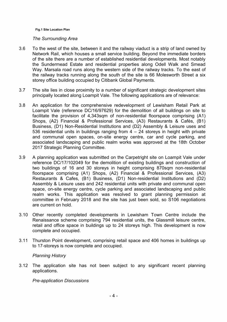
Fig.1 Site Location Plan
The Surrounding Area
3.6 To the west of the site, between it and the railway viaduct is a strip of land owned by Network Rail, which houses a small service building. Beyond the immediate borders of the site there are a number of established residential developments. Most notably the Sundermead Estate and residential properties along Odell Walk and Smead Way. Marsala road runs along the western side of the railway tracks. To the east of the railway tracks running along the south of the site is 66 Molesworth Street a six storey office building occupied by Citibank Global Payments.
3.7 The site lies in close proximity to a number of significant strategic development sites principally located along Loampit Vale. The following applications are of relevance:
3.8 An application for the comprehensive redevelopment of Lewisham Retail Park at Loampit Vale (reference DC/16/97629) for the demolition of all buildings on site to facilitate the provision of 4,343sqm of non-residential floorspace comprising (A1) Shops, (A2) Financial & Professional Services, (A3) Restaurants & Cafés, (B1) Business, (D1) Non-Residential Institutions and (D2) Assembly & Leisure uses and 536 residential units in buildings ranging from 4 – 24 storeys in height with private and communal open spaces, on-site energy centre, car and cycle parking, and associated landscaping and public realm works was approved at the 18th October 2017 Strategic Planning Committee.
3.9 A planning application was submitted on the Carpetright site on Loampit Vale under reference DC/17/102049 for the demolition of existing buildings and construction of two buildings of 16 and 30 storeys in height comprising 870sqm non-residential floorspace comprising (A1) Shops, (A2) Financial & Professional Services, (A3) Restaurants & Cafes, (B1) Business, (D1) Non-residential Institutions and (D2) Assembly & Leisure uses and 242 residential units with private and communal open space, on-site energy centre, cycle parking and associated landscaping and public realm works. This application was resolved to grant planning permission at committee in February 2018 and the site has just been sold, so S106 negotiations are current on hold.
3.10 Other recently completed developments in Lewisham Town Centre include the Renaissance scheme comprising 794 residential units, the Glassmill leisure centre, retail and office space in buildings up to 24 storeys high. This development is now complete and occupied.
3.11 Thurston Point development, comprising retail space and 406 homes in buildings up to 17-storeys is now complete and occupied.
Planning History
3.12 The application site has not been subject to any significant recent planning applications.
Pre-application Discussions
- 5 -
3.13 Pre-application discussions started between the Applicant and Council Officers in November 2016 and continued up until submission of the application in July 2017. A Planning Performance Agreement (PPA) was entered into between the Council and the Applicant to agree appropriate timescales for delivery.
3.14 Four pre-application meetings, three Design Review Panels and meetings with stakeholders including the GLA, Environment Agency, Secure by Design Officer, Flood Officer and the Council’s Housing Officers were held prior to submission of th detail planning applicaion. Details of the meetings and consultation feedback are set out in Section 5 Below.
4.0 Current Planning Applications
The Proposed Development
4.1 The application seeks full planning permission for the demolition of all existing buildings on site and construction of an employment and residential-led mixed use scheme consisting of three development plots linked at upper floors, separated by new pedestrian routes, shared surfaces and interspersed landscaped walkways. In total, the scheme will provide 740sqm (GIA) of commercial floorspace for use as office, retail or performance space (Use Classes B1, A1, A3 and D2) and 136 residential units across three cores.
4.2 The three buildings will be linked from first floor level, and are separated at ground floor to improve access, views and permeability through the site. The development will open up access and views to the River Ravensbourne to the east. The building is a broken “S” in shape to reflect the unusual shape of the land parcel along the curve of the River Ravensbourne to the east, with elevation articulations at ground and first floor level. The east facing part of the scheme is residential in character fronting the riverside public realm, while the west elevation fronting the railway is proposed to be commercial in character.
4.3 The built form is split into four distinct portions. The entrance to the site (north) is proposed to comprise five storeys, with a cut out at ground floor and first floor level. The mid-portion of the building will have a highpoint of 9 storeys, and steps down to 7 storeys towards the north. A further five storey portion links the mid-section with the 16 storey residential tower at the south end of the site.
4.4 The proposal includes enhancements to the River Ravensbourne, as the site lies close to the existing culvert.
4.5 Commercial: The scheme proposes approximately 740sqm of flexible employment uses at ground and first floor. The proposed commercial space is subdivided into six units all located at the ground floor of each of the buildings on the western edge of the development facing out towards the railway embankment. Five of the six units will be flexible B1/A1/A3 and the end (southernmost) unit will be flexible B1/A1/A3/D2 use. Each unit is designed to be adaptable, with the ability to subdivide the units further dependent on the future occupiers need, appealing to smaller businesses and creative industries. The proposal considers that the unit to the far south of the site has the potential to be a performance arts space.
- 6 -
4.6 Housing: The scheme proposes to deliver 136 residential units spread over ground to sixteenth floor, ranging from one bedroom apartments to three bedroom duplexes and a mixture of tenures. The scheme comprises 130 apartments and 6 duplexes. The duplexes are located at ground and first floor level on the eastern side of the building and are clearly articulated through a ‘corrugated’ façade. All residents have access to private amenity space, landscaped riverside gardens and children’s play space at ground floor level.
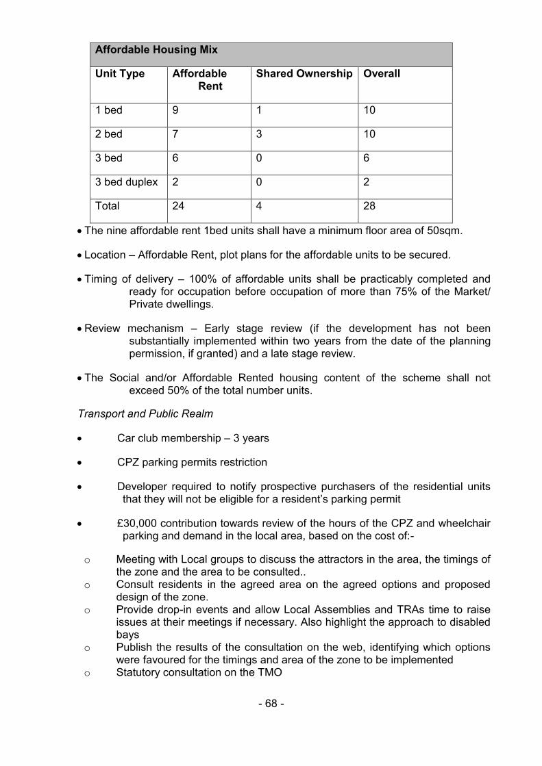
4.7 A total of 28 affordable homes are proposed which equates to approximately 21.6% (by habitable room) or 20.6% (by unit number) of the overall provision. The affordable housing tenure will be split between affordable rent (17.6% in total by unit) and shared ownership (2.9% in total by unit) and is set out further in Table 1 below. The split equates to an affordable split of 86% Affordable Rent, 14% Shared Ownership. This is not a policy compliant split, however the Council’s Strategic Housing team have confirmed that a higher proportion of Affordable Rent is acceptable as these units will meet an identified need.
4.8 The affordable rent is to be located off Core A at the entrance to the site, closest to Lewisham’s amenities, furthest from railway noise and with views of the river. The shared ownership is located off Core B in the mid-portion of the scheme. There is currently no identified Registered Provider proposed.
4.9 The scheme has been designed to be tenure blind and a large proportion of the affordable offer will be family sized units (2+ bed). More specifically, 33% of the Affordable Rented units will be three bedrooms.
Unit Size Affordable Rent
Shared Ownership
Private Market
Total %
1 bed 9 1 38 48 35.3
2 bed 7 3 58 68 50
3 bed 8 0 12 20 14.7
Total 24 4 108 136 100%
Table 1. Proposed Dwelling and Tenure Mix
4.10 Amenity Spaces: All units will have a private inset balcony, with larger units benefiting from a corner balcony. The scheme also roof terraces and podium gardens. The communal terrace on the link building between the tower and the middle section will also incorporate three private terraces, defensible space, childrens’ play equipment, trees, seating and planning.
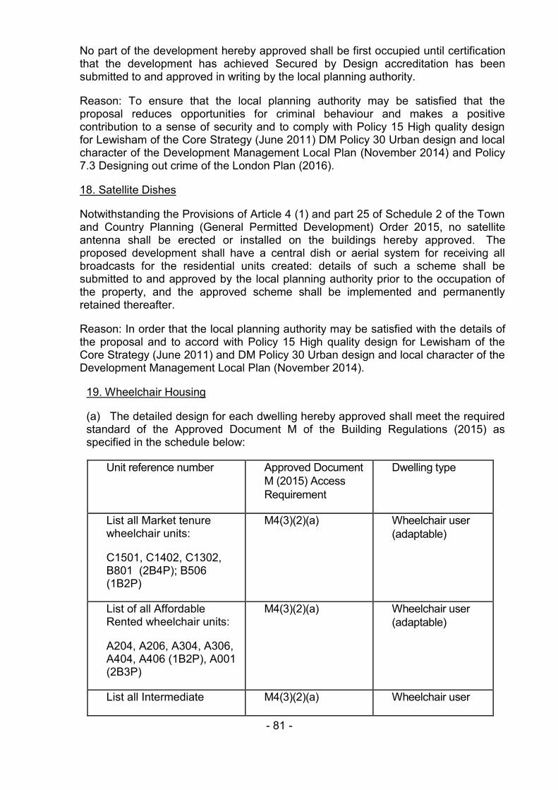
4.11 Accessible Housing: All residential units will be designed to achieve M4(2) housing, with 10% of these being designed to meet M4(3) standards. In total there will be 13 wheelchair accessible apartments.
4.12 Refuse and Recycling: Each core will have a residential bin store which residents can access internally, adjacent to the cores. Each store will be mechanically ventilated and will be equipped with floor drains for regular cleaning. A separate, larger bin store is to be located on the west side of the
- 7 -
site adjacent to the railway where the refuse and recycling bins will be collated by the estate management team ahead of collection by the Council. Commercial refuse collection will be privately managed by the employment units.
4.13 Public realm and landscaping: The proposed landscape aims to create a series of lined routes and spaces which are legible, active and green, maximising access to the river front and creating new public spaces for residents, workers and nearby neighbours. A timber decked terrace will border the development creating a level access around the building, creating defensible space and amenity for the duplex apartments.
4.14 The proposal seeks to create a variety of different public and open spaces including an Arrival Square, a Mews fronting the commercial units, a Riverside Square, and a Workspace Garden. Children’s playspace and playable equipment will be built into communal terraces, podiums and squares.
4.15 Materials: The proposed development will comprise brickwork in ‘Mystique’ soldier course with a bucket handle mortar at upper floors and bronze metal cladding at ground and first floor level. The metal panelling will comprise elements of flat and profiled aluminium cladding.
4.16 Pre-cast concrete coping bands (Portland Stone colour) are proposed to create a distinction between the commercial uses on the residential units above. The banding is proposed to repeat up the building, widening with every other floor to emphasise horizontal form giving way to a slender tower and verticality.
4.17 Composite door and windows are proposed, with openings being simple and regular to express the residential nature of the upper floors.
4.18 Car Parking: The onsite car parking provision is limited to providing no.8 wheelchair accessible car parking spaces. This will be allocated as 3 spaces to the market housing and 5 spaces to the affordable housing and will be provided for within the S106. 20% of the car parking spaces will be active electric vehicle charging. The remainder of the development will be car free.
4.19 Cycle Parking: The proposed development will provide a total of 284 cycle parking spaces, which will be distributed as follows:
Residential 256 internal spaces, which includes 12 short stay
Commercial – 8 long stay spaces and 12 short stay
4.20 Energy and Sustainability: A CHP plant is proposed to provide energy to the development. The single energy centre located on the ground floor west side of the building. All commercial units will meet BREEAM Excellent. Mechanical plant will be built into the communal roof terraces and planting beds and clad in timber. A biodiverse roof incorporating solar photovoltaic roof panels is proposed to the northernmost terrace to restrict access and views overlooking the existing residential properties to the north. The lift over-runs are proposed to be built into the communal and private roof terraces.
- 8 -
4.21 River Ravensbourne Enhancements: The scheme proposes to retain the existing culvert and improve public access next to the river wall in the form of a new riverside space and route alung the site with potential for future links to adjacent sites. The proposed development will be positioned generally in excess of 8m from the edge of the river; however there is a pinchpoint of approximately 6m from the building façade to the river.
4.22 Scheme Revisions: Following a review of the original scheme, officers considered that the height, scale bulk and massing were unacceptable. The original scheme of 156 units, the proposal would have an unacceptable impact on the amenity of the neighbouring occupiers as such the scheme was revised to address concerns raised by officers. The following key design refinements form the basis of the revised submission:
The reduction in massing of the proposals; the northern-most building by a single storey and the middle potion of the building by two storeys.
A reduction in the overall residential accommodation and change to tenure mix.
Updates to the elevation design following changes to massing.
The addition of photovoltaic panels to the northern- most terrace to serve the non-residential uses.
4.23 As well as receiving a revised set of drawings, the following documents were revised in May 2018 to reflect the changes made to the scheme:
Affordable Housing Statement
BREEAM Pre-assessment Report
Daylight, Sunlight and Overshadowing report
Energy Strategy ad LZC Report
Heritage, Townscape and Visual Impact Assessment
Air Quality assessment
Design And Access Statement Addendum
Noise and Vibration Assessment
Transport Assessment
Wind Microclimate
Financial Viability Assessment
Supporting Documents
- 9 -
4.24 In addition to the plans and drawings, a number of supporting documents have been submitted (and subsequently revised) with the application. The supporting documents are briefly summarised below.
4.25 Design and Access Statement (DAS) and DAS Addendum (incorporating crime prevention, landscaping, accessible and adaptable dwellings, lighting, materials, open space, photographs, river impact and corridor study, site waste management and wheelchair statement) (prepared by PRP architects) The DAS provides an overview of the proposals. It starts by describing the context before outlining the design process and consultation (including public consultation, pre-application discussions with Lewisham, GLA and TfL officers and discussions at Lewisham Design review Panels) and the design response.
4.26 Planning Statement (prepared by DP9). The Planning Statement provides a summary of the development and the nature and structure of the planning application. It also sets out the policies that the Applicant considers relevant to the proposals and sets out the policy justification for the proposal. Financial Viability is the subject of a separate Financial Viability Assessment.
4.27 Heritage, Townscape and Visual Impact Assessment dated May 2018 (prepared by WYG). This report considers the physical context of the site and its surrounding through an in-depth Heritage, Townscape and Visual Impact Assessment. It provides an assessment of the proposal and their impact on the townscape and local views. The report advises that the redevelopment of the site would provide significant improvements to the local area, would contribute positively to the skyline, open up the riverside and improve connectivity between river side and surrounding area. Due consideration has been given to the proposals relationship with the existing surrounding residential development.
4.28 Affordable Housing Statement and Addendum (prepared by DS2). This document sets out the affordable housing offer for the proposed development and addresses policy priorities for affordable housing delivery. It confirms that the affordable housing offer has been calculated on the basis of the maximum viable and sets out the breakdown between proposed tenures and mix.
4.29 Employment Land Report dated March 2017 (prepared by JLL). This document provides an objective assessment of employment land issues in the context of the proposed mixed use redevelopment of the site. The report concludes that the existing site is no longer suitable for industrial uses and that the alternative use of the site and re-provision of high quality employment space should be supported.
4.30 Daylight, Sunlight and Overshadowing Report V.03 dated May 2018 (prepared by Point 2 Surveyors). This document provides an assessment of the internal daylight and sunlight amenity within the proposed scheme. The methodology follows BRE guidance. The daylight assessment is calculated using Vertical Sky Component (VSC), No-Sky Line Contour (NSC) and Average Daylight Factor (ADF). For sunlight the Annual Probably Sunlight Hours (APSH) is detailed. The report confirms that the quality of daylight within the scheme 92% of the rooms analysed meet their respective ADF requirements, which shows that 94% of rooms across the proposed development will meet the
- 10 -
relevant standard which is considered typical of a central London development. The report confirms that the overshadowing of the proposed development upon surrounding properties falls within the guideline recommendations on all cases.
4.31 Energy Strategy and LZC Report dated May 2018 (prepared by Desco). This report sets out the development strategy for meeting local and strategic energy and emission targets. The site proposes a site wide district heating with gas fired CHP and that overall the site missions provide a 38% improvement on combined building regulations L1 and L2 target emissions. The report confirms that further payments will be met by way of a cash in lieu payment.
4.32 Noise and Vibration Assessment dated May 2018, (prepared by WSP). This document considers the likely impact on the proposed development from plant serving the adjacent buildings and from noise and vibration generated by the surrounding roads and railways. The report also sets out plant noise emission criteria which new items of building services proposed for the development must meet. The report concludes that the external noise ingress criteria can be achieved with typical double glazing and the proposed mechanical ventilation and the probability of train-induced vibrations is predicted to be low and would not cause any significant disturbance or annoyance to future occupiers.
4.33 Air Quality Assessment dated May 2018 (prepared by WSP). This document provides an overview and assessment of the potential air quality impacts arising from the proposed redevelopment of Axion House during the construction phase and the potential exposure of future residents to poor air quality given the sites location within an Air Quality Management Area; and emissions to air from the proposed energy centre. Generally, the residual effects of the development on future residents would be insignificant, with some slight adverse effects. The report concludes from preliminary findings that the scheme is not air quality neutral as the performance against the Building Emission Benchmark for NOx emissions was found to be deficient. The report recommends that once the exact CHP plant specifications for the energy centre are confirmed that the air quality neutral assessment should be revisited.
4.34 Sustainability Statement Rev 3 dated May 2018 (prepared by Hilsdon Holmes). This document makes an assessment of the proposed development against a number of sustainability policies and indicators, notably energy and carbon dioxide emissions, water efficiency, materials, waste, nature conservation and biodiversity and sets out mitigation against climate change, and pollution management.
4.35 BREEAM Pre-assessment Report Rev 3 dated August 2018 (prepared by Hilsdon Holmes). This report provide a route to a minimum BREEAM score of 70% which, if minimum standards are met will achieve an ‘Excellent’ rating. The report assumes that the proposed use of the commercial units with be light industrial and the pre-assessment has been completed on this basis. Based on the pre-assessment the development is predicted to obtain a score of 71.9
- 11 -
4.36 Statement of Community Involvement (SCI) dated May 2018 (prepared by Four Communications). This document summarises the process of public consultation that has been undertaken to date.
4.37 Archaeological Desk Based Assessment dated June 2017 (prepared by CgMS). This document is a review of the archaeological potential of the application site, and concludes that the site is thought to have a medium theoretical potential for Anglo-Saxon, Medieval and Post Medieval period but the overall significant of the archaeological deposits present on site are low/local. The recommendation is that no further archaeological work is required.
4.38 Construction Management Plan dated June 2017 (prepared by Chapman and Chapman Construction Consultants). The CMP details how the critical construction activities will be undertaken, managed and constructed efficiently under controlled environmental conditions.
4.39 Extended Phase 1 Ecology Survey dated June 2017 (prepared by Richard Graves Associates Ltd). This document details the findings of a Phase 1 habitat survey and desktop study, undertaken at the site. The report details that the majority of the site comprises buildings and hard standing in a good state of repair and is low ecological value. No evidence of roosting bats. The site has potential habitats for nesting birds and common reptiles and there is evidence of Japanese knotweed. It concludes that the proposed development does would be acceptable with regard to ecology.
4.40 Flood Risk Assessment dated June 2017 (prepared by Heyne Tillett Steel). The FRA makes an assessment of the proposed development within the context of the site falling within Flood Risk Zone 3a. The floor level of the proposals will be raised 300mm above peak flood water levels, with dry access/egress provided via a raised walkway. The report considerd the proposed the development to be acceptable and to have passed both the sequential and exception tests. The proposed development will not result in a loss of flood water storage. The report sets out a drainage strategy with surface water discharging to the River Ravensbourne.
4.41 Phase 1 Environmental Assessment dated March 2017 (prepared by AP Geotechnics). This report details the walk-over survey and historic map assessment for contamination on the site. The report concludes that previous activities on the site represent a moderate to high risk of contamination on the site, which is to be expected on an inner city site. A moderate to high risk of ground gas emissions has also been identified.
4.42 Phase 2 Environmental Assessment dated May 2017 (prepared by AP Geotechnics). This report details the result of the contamination investigation. The purpose of the investigation was to establish the presence of any contaminants and to provide recommendations in respect of any necessary remediation. Chemical analysis revealed significant lead and polyaromatic hydrocarbon contamination across the site and a 600mm clean cap is recommended in areas of soft landscaping.
- 12 -
4.43 Tree Survey dated 22nd November (prepared by Ian Keen Limited). This document notes that there are four Category C trees on site, none are protected by a TPO.
4.44 Ventilation Report dated July 2017 (prepared by DESCO). This report sets out the proposed mechanical ventilation systems and location of proposed louvres associated with the redevelopment of the site.
4.45 Wind Microclimate report dated June 2017 (prepared by Urban Microclimate Ltd). This document details the wind modelling and assessment undertaken of the proposed development. It report concludes that the proposed development creates a wide obstruction to the south-westerly prevailing winds and is no expected to have any significant impact on the pedestrian level wind conditions in the surrounding area and that occupiers will be able to enjoy a safe environment for all users.
4.46 Wind Microclimate addendum letter dated May 2018 (prepared by Urban Microclimate Ltd). This letter reassesses the scheme in light of the revisions undertaken, specifically the reduction in height of the central Block (Core B) from 11storeys to 9 storeys and the north block (Core C) from 6 storeys to 5 storeys. The letter concludes that the reductions in height are unlikely to affect the suitability of conditions for the planned activities and the conclusions of the June 2017 report remain valid.
4.47 Transport Assessment dated May 2018 (prepared by WSP). This document includes a PERS Audit of pedestrian routes around the proposed development site and assess the proposed developments impact on the surround transport network infrastructure. It also sets out information relating to the stopping up of Silver Road, cycle and car parking and Delivery and servicing.
4.48 Framework Travel Plan dated May 2018 (prepared by WSP). The Travel Plan describe the site’s accessibility for pedestrians, cyclists and public transport users and outlines travel planning measures and initiatives to encourage future occupiers/visitors/residents to use sustainable modes of transport. They also set out monitoring and review arrangements and management and co-ordination issues.
4.49 Financial Viability Assessment dated May 2017 and Financial Viability addendum dated May 2018 (prepared by DS2).
5.0 Consultation
5.1 This section outlines the consultation carried out by the Applicant prior to submission of the planning application and by the council following its receipt and summarises the responses received.
Pre-Application Consultation
5.2 The Applicant held two public consultation exhibitions at the pre-application stage. The first exhibition was held at the Ecclesia Church Hall on 7 and 1- December 2016 and attracted 12 people. The second was held on 10 and 11 February 2017 at the Glass Mill Leisure Centre and attracted approximately 70 attendees. Attendees at the exhibitions included ward councillors, onsite
- 13 -
occupiers, representatives from local businesses and residents on neighbouring streets.
5.3 An e-mail address has been made available to the local community. The applicant also met with Vicky Foxcroft MP to give a private presentation. Full details are included within the submitted Statement of Community Involvement.
Council Consultation
5.4 The Council’s consultation was undertaken in accordance with the minimum statutory requirements and those required by the Council’s adopted Statement of Community Involvement.
5.5 Letters were sent to residents and businesses in the surrounding area. Emails providing a link to the application details were sent to the relevant ward Councillors, site notices were erected around the site and a press notice in the local newspaper.
5.6 The following statutory consultees and stakeholder were also consulted:
Transport for London Surface
Network Rail
Historic England
Greater London Authority
Environment Agency
Historic England – Areas of Archaeological Priority
Thames Water
Natural England
Met Police Designing Out Crime Officer
5.7 The following local groups were consulted:
The Ladywell Society
Lewisham Cyclists
Lewisham Deptford Constituency GC
5.8 The following Council services were consulted:
Lead Local Flood Authority (LLFA)
Ecological Regeneration
Environmental Health
- 14 -
Urban Design
S106/CIL
Planning Policy
Legal Services
Highways
Drainage
District Surveyor
Road Safety and Sustainable Transport
5.9 Consultation on the minor revisions to the reduction in height was carried out in June 2018 in the form of site notices and a press notice in the local newspaper. Consultation letters were sent to the neighbours.
Written Responses received from Local Residents and Organisations
5.10 At the time of writing of this report a total of 242 representations have been received. A petition signed by 162 local residents has been submitted in objection of the application.
5.11 Objections received are addressed within the planning considerations section of the report. A summary of the comments received is set out below:
Environmental – contaminated land, intrusive, wind tunnel effect, increase in air pollution as a result of increased traffic and congestion
Location –dead end at the end of a road.
Affordable Housing; not enough proposed; doubt that 30% of units will be shared ownership/affordable.
Scale and massing – Too big when considered against the scale of neighbouring residential properties along Odell Walk, Smead Way and Marsala Road; proposal will not help the housing crisis, too dense and should be low-rise social housing like Cornmill Gardens; too dense; overdevelopment of the site and intrusive.
Network Rail site should be developed at the same time; masterplan approach
Tall Building – overbearing on small scale neighbouring properties; inappropriate for this part of Lewisham, setting a precedent for future developments; this site falls within the sensitive area and is not suitable for a tall building; should be five storeys maximum.
Design – poor quality
- 15 -
Amenity - Overlooking and privacy of gardens along Odell Walk. Affect right to quiet enjoyment of the gardens along Odell Walk; Overshadowing and impact on sunlight and daylight to existing properties; Lack of amenities, e.g. greenspace, impact on school places and medical care facilities; unacceptable impact existing residents as a result of increased noise and evening activity from commercial activities.
Riverside – dead end cycle path/walkway id not making the river publicly accessible and does not meet the Council’s aspirations in the River Ravensbourne Corridor Improvement Plan
Traffic – increase congestion in an area of heavy traffic; impact on already oversubscribed transport infrastructure; increase in cyclists
Connectivity - No clear links to the town centre, along the river or the Ladywell Fields.
Trees and Landscape – Silver Road has no planting or trees, also loss of existing trees and planting on site,
Flooding – proximity to the river Ravensbourne will increase risk of flooding. No flood storage areas
Skyline – unacceptable impact on the London Skyline and views from residential properties.
The scale is incompatible with the Lewisham Town Centre Masterplan.
Ecology – Impact on local and rare wildlife; Overshadowing the river affecting biodiversity
No public benefits
Noise, pollution, traffic and disturbance from construction and related vehicular movements
How will commercial units be viable where new commercial premises in town centre remain vacant
Impact of foundations on existing railway and river infrastructure
5.12 Local objections relating to non-material planning considerations can be summarised as follows:
Health – high rise blocks increase risk of mental health issues include depression and stress
Developers are building for greed not need – money making.
Loss of visual amenity and views from surrounding properties
Violation of human rights
- 16 -
Procedure – consultation responses required during school holidays.
Too many developments being constructed concurrently
Paint the railway bridge on Ellerdale Road and re-landscape Silver Road.
Current fly tipping due to the eviction of the creative industries and artists.
Anti –social behaviour from older school children, lingering around the site.
Land not suitable for development due to subsidence.
The questions asked by developers during public consultation were weighted in their favour.
Development will increase amount of litter
Build more council housing
5.13 Local support can be summarised as follows:
Glad to see more housing prioritised
5.14 A petition signed by 162 local residents has also been received.
5.15 In addition to the original consultation responses, petition and further responses, many objectors have submitted a completed Silver Road Complaint Letter which provides a template to object on the grounds of:
Car Parking, Shadowing, Flooding, Over-crowding, Lack of Amenities, Aesthetics, Noise, Lack of Public Provision, Lack of Affordable Housing, Building Disruption, Speculator Profits, Out of place, Pollution, Subsidence, Disabled Parking, Building Nuisance.
The Ladywell Society
5.16 It is regrettable that yet another tall building is proposed for central Lewisham. The 16 storey tower would overpower the houses in Odell Walk and other low rise residential buildings in Smead Way, Pine Tree Way etc. It would also intrude into the airspace of Marsala Road. The CGI of the view from the Ladywell Road bridge (fig. 72 of the Visual Impact Statement) also shows that the 16 storey tower would be another unwelcome addition to the skyline, but the lower building appears to be more acceptable.
5.17 The Society notes that the applicant is suggesting that 29% of the units in the proposed development are “affordable”, with the majority being “affordable rent”. Although the term “affordable” can be regarded as a misnomer, given the level of market rent charges in central Lewisham, the Society feels that this is a step in the right direction. It would be a disappointment and a cause for concern if the applicant subsequently applies to reduce the number of units.
The Ladywell Labour Party
- 17 -
5.18 The ward notes the proposed development for the construction of 4, 6, 9 and 15 storey flats on Silver Road (backing onto Marsala Road, Smead Way and Odell Walk). It further notes the considerable local opposition to the scheme.
5.19 The ward believes that such a development is not in the interests of the local residents and will severely damage their quality of life through; shadowing, extra traffic and cars, the lack of appropriate amenities etc.
5.20 There is a more general issue about the scale of development in Lewisham centre the high rise there is a fait accompli which has put pressure on the local infrastructure. More development of this nature on the Silver Road site and other areas such as the wear side depot is not acceptable or appropriate to a residential area such as Ladywell.
Lewisham Cyclists
5.21 We would like to see the developers build (or fund) a link towards Ladywell/Molesworth Street either under or over the railway which has always been a long term objective for National Cycle Network 4. A bridge was built across the river by the 256 Lewisham High Street, London, SE13 6JX development and a similar link would help in achieving this aim.
5.22 The transport assessment does state that Ladywell is a useful public transport link and this application part funding the link would assist future residents to travel sustainably which is key to many Lewisham Council policies.
Lewisham Deptford Contitutency GC
5.23 No representations recevied
Local Meeting
5.24 Given the level of local interest in the proposals, those people that had commented on the proposals at the end of the three-week local consultation period were invited to a local meeting, which took place on 16th October 2017 at the Ladywell Centre, Ladywell Road, SE13 7EP at 6.30pm. The meeting was chaired by Cllr Joan Reid, ward member for Lewisham Central. A copy of the minutes is attached as an Appendix.
5.25 The key points raised at the meeting included:
Why were residents not informed of the proposals at the pre-application stage?
Consultation being undertaken during school holidays.
Design led approach is welcomed but the development is too high.
High-rise development is unacceptable in a sensitive area, this will allow encroachment and extension from the Gateway.
Loss of sunlight, which does not meet legal requirements.
- 18 -
Increase risk of flooding.
Loss of privacy is against the Human Rights Act.
Concerns about impact on local infrastructure, schools and GP’s.
Impacts on transport infrastructure and parking demand in the local area.
The affordable offer is not affordable, what is the definition of affordable?
Requests for a condition restricting who is eligible to buy the units.
Written Responses received from Statutory Agencies
Greater London Authority
5.26 The application is one of potential strategic importance under Category 1A, 1B, and 1C of the Town and Country Planning (Mayor of London) Order 2008. The application is therefore required to be notified to the Mayor of London.
5.27 The GLA provided its Stage 1 response letter on the proposals on 30th October 2017. The letter states that the Mayor considers that the application does not comply with the London Plan, but that possible remedies could address these deficiencies.
5.28 Principle of development: Whilst the loss of the existing lawful B8 use is acceptable, the applicant should investigate the re-provision of creative industries as part of the flexible commercial proposal.
5.29 Housing: The [original] affordable housing offer of 29.4% is unacceptable, given the high-density nature of the proposal on an existing low-grade industrial site. GLA officers will robustly interrogate the applicant’s viability assessment.
5.30 Design: access and connections should be reviewed to ensure this high density proposal is appropriately knitted into the public realm network. Residential cores should be repositioned. High number of north-facing units.
5.31 Energy: overheating and cooling information is required; passive design and energy efficiency measures for the commercial elements must be investigated; and details of the CO2 emissions offset payment
5.32 Flood Risk: further flood resilience across the site is required and a green SuDS system should be secured.
5.33 Transport: the proposals will increase pressure on the DLR network therefore a contribution towards upgrading capacity must be secured.
5.34 Following submission of the revised scheme, the GLA has provided an updated response to the Stage 1 response.
5.35 Affordable Housing: The reduction in affordable housing offer from 29% to 20% will be difficult for the Mayor to support and requested further details of
- 19 -
the rationale behind the proposed affordable housing tenure split. Preferred original submission as higher quantum of affordable housing would be achieved.
5.36 A number of concerns relating to energy efficiency, overheating, cooling, passive design and carbon emissions have been sufficiently addressed through additional information provided to the GLA and updated reports with the revised submission.
Transport for London
5.37 In summary, TfL have no objections to the principle of this development and provided specific comments below:
5.38 Trip Generation/ Mode Share: TfL considered the increase in two-way person trip generation is reasonable and acceptable. No adverse impact on local bus capacity, however the DLR is now operating over capacity and the additional demand generated from this development would place further strain on the DLR network.
5.39 TfL request a Grampian condition preventing the occupation of the development prior to May-2022 to allow for upgrading works and increase in capacity. This will be addressed further in the Transport section of the Planning Considerations.
5.40 Cycle Parking: Accords with London Plan policy and should be secured via condition.
5.41 Car Parking: Blue Badge disabled parking and no permits for the surrounding CPZ is strongly supported and should be secured by planning obligation. Electric Vehicle Charging Points should be secured by condition and encourages the developer to consider 80% passive charging spaces.
5.42 Deliveries & Servicing: TfL welcomes that all deliveries and servicing can be accommodated on site however have some concern over the potential legibility of the scheme from the perspective of delivery or service vehicles. Request for a pre-occupation condition for a Delivery and Servicing Plan incorporating a signage strategy.
5.43 Construction Logistics: TfL supports the matters covered in the Construction Management Plan, however would still like to see final construction logistics arrangements prior to any demolition or construction work onsite, which include details on anticipated vehicle numbers/ timings) to be developed with reference to other schemes proposed to commence in the area.
5.44 TfL has ongoing concerns with the level of construction being undertaken (and proposed) in Lewisham Town Centre and the impact this is having on walking, cycling and bus services in the area.
Environment Agency
5.45 The Environment Agency raised no objection to the planning application as submitted, subject to a number of conditions, informatives and planning
- 20 -
obligations being imposed should planning permission be granted. Without the proposed conditions, the proposed development on this site poses an unacceptable risk and the EA would object to the planning application.
5.46 Detailed technical comments pertaining to flood risk, flood mitigation measures, proximity to watercourse, ecology and biodiversity, including opportunities for river restoration, ground water and land contamination were provided. The EA consider there is missed opportunity for river restoration within the development.
5.47 The following conditions have been requested:
Finished floor levels shall be set no lower than 9.53m above Ordnance Datum (AOD)
No permanent structure within 6m of the river wall and that non-permanent structure could reasonably be removed to permit maintenance and improvements works to the river wall.
Details of Tree planting, root containment and protection.
Method statement and loading plan for any works within 8m of the river wall.
Development shall be carried out in accordance with the recommendations and enhancements set out in the ecological survey.
Remediation strategy
Verification report
5.48 The Environment Agency have also requested a bespoke planning obligation to be included within the S106 Agreement due to the close proximity of the river wall to the proposed development:
‘In the event that River Wall Works are required that, in the reasonable opinion of the Environment Agency or the Council, necessitate the temporary removal of any of the River Wall Structures, the Environment Agency or the Council shall serve a River Wall Notice upon the Owner/Developer.
Following receipt of a River Wall Notice the Owner/Developer shall submit for the Council's approval (in consultation with the Environment Agency) a timetable for the removal and re-instatement of the relevant River Wall Structures, such removal to occur within two months of receipt of the River Wall Notice or within such longer period of time as may be approved by the Council in consultation with the Environment Agency such approval not to be unreasonably withheld, with all costs associated with compliance with the River Wall Notice to be at the Owner/Developer’s expense’
Historic England (Greater London Archaeological Advisory Service)
5.49 The GLAAS raised no objection to the proposed development, and having considered the submitted archaeological information in the submitted
- 21 -
archaeological desk-based assessment report dated June 2017 could recommend its approval. No further assessment or conditions are therefore necessary.
Network Rail
5.50 No representations were received
Lead Local Flood Authority
5.51 Raised an objection to the planning application as insufficient information was provided to determine if the site drainage meets the requirements of the NPPF and the London Plan Policy 5.13.
5.52 The LLFA will consider reviewing this objection if the following issues are adequately addressed:
Provide justification for the site impermeable area and/or updated runoff calculations if required.
Provide revised calculations considering appropriate freeboard in the drainage system.
Provide further supporting evidence to demonstrate that overland exceedance flows will be safely managed, without increasing flood risk to surrounding areas.
Metropolitan Police Designing Out Crime Officer
5.53 Raised no objection to the application. The DOCO confirmed that pre-application meetings were held and the principles of Secured by Design were discussed, and welcomed the inclusion of SBD within the development. Request for the development to achieve Secured by Design accreditation by condition.
Natural England
5.54 No comments to make on this application
Thames Water
5.55 Waste Comments: The proposed development is location within 15m of a strategic sewer. Advise that with regard to waste water network and waste water proves infrastructure capacity, raise no objection. Conditions requested.
5.56 Surface Water Drainage Comments: If the developer follows the sequential approach to the disposal of surface water raise no objection. Where the developer proposes to discharge to a public sewer, prior approval from Thames Water Developer Services will be required.
5.57 Water Comments: Thames Water has identified an inability of the existing water network infrastructure to accommodate the needs of this development proposal. Thames Water have contacted the developer in an attempt to agree a position on water networks but have been unable to do so in the time
- 22 -
available and as such Thames Water request that the following condition be added to any planning permission. Conditions requested.
5.58 Following initial investigations Thames Water has identified that the proposed development is located within Source Protection Zone of a groundwater abstraction source. These zones are used for potable water sources for public water supply for which Thames Water has a statutory duty to protect. Thames Water have contacted the developer in an attempt to agree a Source Protection Strategy but have been unable to do so in the time available. Conditions requested.
Historic England
5.59 No representations received
Lewisham Design Panel
5.60 The LDRP considered emerging proposals on three separate occasions during the pre-application stage (28th September 2016, 17th January 2017, 29th March 2017) The comments of the Panel following its last review of the scheme at the pre-application stage can be summarised as follows:
LDRP Summary Officer Comment
The Panel were of the view that the scheme had in general progressed well since the January 2017 review, and that the simplified form and architectural treatment was working well. In particular the latest iteration of the project was closer to the elegance of the original (first review) concept and the slab like quality which had emerged at second review, had been largely eliminated.
Noted. The architectural treatment will be discussed further within the Planning Considerations section.
At earlier review, the Panel felt that the justification for scale and height of the proposals was not wholly clear in the scheme’s current form. The new structures will be considerably taller than the surrounding buildings typically two to six storeys and therefore the rationale for its setting and positive contribution to the surrounding townscape needs to be clearly articulated. The Panel debated LBL’s concerns on scale and height, and whilst the buildings proposed were considerably taller than those around and that the site was not designated for tall buildings, the careful townscape analysis, the study models and the distant view studies and the high quality CGIs showed that the site and its context could accommodate buildings of the size and high quality envisaged.
Noted. The full planning application has been submitted with a supporting Heritage, Townscape Visual Impact Assessment to justify the height and scale of the proposed development. This will be addressed further in the planning considerations section of this report.
As noted at earlier review, employment space on An Employment Land Report
- 23 -
the site is clearly an important planning policy, and demand for the project’s commercial spaces needs to be properly market tested. Given the somewhat remote nature of the site from a commercial perspective, plans must be put in place to ensure that the spaces are viable and occupied. In particular, some concern was expressed over the viability of the most southerly of the commercial units located in the acute angle of the site formed by the two railway lines at their crossover. Various alternate uses were suggested including artists studios or theatre/events space. Further work is needed by the applicant team to put forward convincing viable proposals for this space.
has been prepared in support of the planning application, and assessed within the Planning Considerations.
Further work is needed in the Panel’s view to communicate the distinction between residential and commercial spaces, in particular the clarity of means of access for the visitor to ensure that the commercial and residential spaces can both operate successfully independent from one another.
The proposal has incorporated signage and materiality to distinguish the two elements of the scheme. This is discussed further in the Planning Considerations section.
At earlier review, the Panel remarked that the deck width to separate private amenity space from the communal deck was too narrow, comprising the privacy of the ground level duplex occupants. Further work is also needed to resolve the division between private amenity space and the public realm on the riverside, including further investigation into the section and the
It is considered that sufficient progress has been made on the defensible space. The walkways have been set at the lowest level above the flood plain. The depth of defensible space is circa 1.75m and is typical for new London developments. A fairly low footfall along these walkways is also expected.
The Panel supported LBL officers’ view with regard to defining a strategy and delivery mechanism with EA to develop the naturalisation of the River Ravensbourne.
This is discussed further within the Planning Considerations, however due to the constraints of the site, full naturalisation of the River Ravensbourne has not been proposed within this application.
Table 2: Lewisham Design Review Comments
Strategic Housing
5.61 In terms of the percentage of affordable housing, we are pleased that there is on site provision and that the applicant states that the development is tenure blind.
- 24 -
5.62 Looking at the affordable mix, it is noted that the policy position of 70:30 is not being met, however with approx. 9600 households on the Council’s housing register the larger provision of affordable rent (86:14) is acceptable.
5.63 In terms of the unit size mix, the demand for 1 beds is far lower than larger accommodation. It is therefore disappointing that 38% of the affordable rent mix is for 1 bed properties and we would very much like to see less 1 beds in favour of more larger homes.
5.64 Following negotiation, the affordable rent levels are now agreed.
5.65 In regards to the intermediate offer, there are no further comments.
Sustainability Manager
5.66 No representations were received.
Highways and Transportation
5.67 The Councils Highways team were consulted on the application and raised no objection to the scheme in principle though requested clarifications and S106 obligations to mitigate the anticipated highways impacts:
Swept path analysis showing two-way vehicle movements within the site and between the site access and Elmira Street. Awkward pedestrian environment when vehicles are manoeuvring. No loading bay within the site for servicing the commercial units and residential deliveries.
Quantum of disabled parking does not meet London plan policy, also need to demonstrate that overspill car parking does not have impact on the surrounding streets at the time when the CPZ is not in operation. Request for an overnight parking survey to be secured by condition.
Financial contributions sought towards review of CPZ and blue badge parking survey in the local area.
Clarification on controlling number of HGV’s on site at a time and delivery vehicles. Will there be a booking system?
Delivery and servicing plan should set out the servicing strategy
A waste management strategy should be provided and it should include/differentiate between residential and commercial bins store
Bike stores aren’t conveniently located, there are 3 sets of doors to go through for Cycle store A.
The doors to the bike store are not wide enough, the doors should be at least 1m wide. Require details of the cycle stands that will be used in the stores.
o The Applicants Transport Consultant has submitted an additional information note including swept path analysis. Officers considered
- 25 -
the information suffiently addresses concerns raised by Highways, and the note will form part of the approved documents list.
5.68 Highways officers also requested the following S106 planning obligations and conditions to secure the following:
Residents being excluded from obtaining CPZ permits
Contribution towards a review of the CPZ
3 year free membership for a Car Club and a car club strategy is required for the development, It should include an assessment of the existing car club infrastructure in the vicinity of the site to determine if another car club bay is required. And confirmation that membership will be provided for residents for 3 years
Meeting the cost of improvements to the pedestrian environment identified in the PERS audit
Improvements to the lighting under the bridge on Link 13 (Elmira Street)
Tactile paving on Link 18 (Elmira Street)
Improvements to the footway which currently is not wide enough for wheelchair users (Link 12 –Silver Road to Elmira Street)
A full Residential Travel Plan and Commercial Travel Plan Statement.
Given the nature of the area and the number of other schemes coming forward at a similar time a draft Construction Logistics Plan/Construction Management Plan should be included as a chapter within the Transport Assessment. The Construction Logistics Plan should consider the construction phasing of committed developments in the Town Centre, particularly Lewisham Gateway. It should also confirm that the applicant will participate in Lewisham Town Centre zonal CLP.
o The above requests will be reviewed as part of the planning S106 negotiations.
Other
Environmental Health Contamination
5.69 The Environmental Site Assessment indicates that the ground is substantially contaminated, there is a risk that piled foundations will transfer ground water and contaminants between strata. The developer should have to prove that all necessary measures have been taken to prevent this occurring.
5.70 The Council’s Contamination Officer raised the following queries and requests for additional information/clarification:
How will the development prevent run off from the site ansferring contaminants to the River Ravensbourne?
- 26 -
Although groundwater was encountered there does not appear to have been any sampling or chemical analysis undertaken, which would be expected given its proximity to controlled waters.
o The Applicant submitted a Phase III Geoenvironmental Assessment setting out the sampling and chemical analysis undertaken. EHO accepted reports findings with respect to groundwater but advised that EA should be consulted on the information. It is considered that these matters can be dealt by condition.
A full assessment for potential Unexploded Objects (UXO’s) should be undertaken.
o The Applicant provided a full UXO report, the findings of which were accepted by the Council’s EHO. EHO requested recommendations in UXO report should be undertaken. UXO report to be included within list of approved documents.
Given the presence of a vehicle workshop and other commercial processes clarification is requested whether any above/below ground storage tanks are present on site, and whether any associated drainage interceptor systems were present?
o The Applicant confirmed that no above or below ground storage tanks were found, and that interceptor traps were found on site. The Councils EHO requested details of whether contamination was found in the interceptors and details of any remediation measures. To be secured by condition.
It is not clear whether specific testing was targeted in the location of vehicle testing for potential hydrocarbon contamination? Also VOC testing associated with the industrial paint spraying.
o The Applicant provided a Phase III Environmental Assessment confirming the results of Bore Hole testing. EHO raised further queries. These matters can be dealt with by condition following approval.
Asbestos Survey Details of asbestos and what measures will be undertaken should this material be encountered during works.
o The Applicant provided a Phase III Environmental Assessment. The Council’s EHO was not satisfied with the report with respect to asbestos. These matters can be dealt with by condition following approval, in conjunction with consultation with the HSE.
Clarification is required as to what materials are in the containers, alarmingly what is in the grave, and were there any contaminative processes associated with the brickworks?
o The applicant confirmed the containers were water tanks, which were converted into a performance space and a café. The grave referred to an animal (cat). EHO was satisfied with response.
- 27 -
Clarification on whether there will be any private gardens/communal areas where fruit and vegetables could be grown for consumption?
o The Applicant confirmed that no facilities for fuit and vegetable growing would be provided. The Council’s EHO requests remediation strategy, this will be controlled by condition.
Environmental Health Air Quality Assessment
5.71 The application site falls within an Air Quality Management Area. There therefore needs to be a proportionate cost towards the management of air quality and where development increases the number of people being exposed to poor air quality and/or increases transport trips to and from the area.
5.72 The Council has an existing air quality-monitoring network, which allows for verification and validation of air quality prediction models.
5.73 In order to meet the construction management responsibilities that the Environmental Protection Team have made a request for a financial contribution of £15,000 costs towards these expenses. The costs are based on £100 per residential unit and £100 per 100m2 non-residential floor space.
5.74 This will be secured within the S106.
5.75 A further comment was received during the re-consultation noting that the proposed developments performance against the BEB for NOx emissions was found to be deficient. A condition was requested to ensure that the air quality neutral assessment be revisited as outlined.
Ecological Regeneration
5.76 The Councils ecology officer raised no objection to the proposed development and recommended conditions and number of informatives. The following conditions were requested:
The recommendations made in the ecology report to be implemented in full.
Prior to occupation, a “lighting design strategy for biodiversity” for 1 Silver Road development and its relationship with the River Ravensbourne shall be submitted to and approved in writing by the local planning authority. The strategy shall:
o a) identify those areas/features on site that are particularly sensitive for bats and that are likely to cause disturbance along important routes used to access key areas of their territory, for example, for foraging; and
o b) show how and where external lighting will be installed (through the provision of appropriate lighting contour plans and technical specifications) so that it can be clearly demonstrated that areas to be lit will not disturb or prevent the above species using their territory or having access to their breeding sites and resting places.
- 28 -
All external lighting shall be installed in accordance with the specifications and locations set out in the strategy, and these shall be maintained thereafter in accordance with the strategy. Under no circumstances should any other external lighting be installed without prior consent from the local planning authority
Bird and Bat boxes
Lighting if used during construction and or operation should be directed away from vegetation, trees and wildlife corridors, minimise impact on bats.
Any clearance of scrub and trees within the site should be timed to avoid the bird nesting season (March to August).
A pre-construction survey
Prior to the start of works on site the contractor should receive a ‘toolbox’ talk to describe the ecological features and species present, their legal protection and responsibilities towards them and what to do if wildlife is encountered.
6.0 Policy Context
Introduction
6.1 Section 70(2) of the Town and Country Planning Act 1990 (as amended) sets out that in considering and determining applications for planning permission the local planning authority must have regard to:-
(a) the provisions of the development plan, so far as material to the application,
(b) any local finance considerations, so far as material to the application, and
(c) any other material considerations.
6.2 Section 38(6) of the Planning and Compulsory Purchase Act (2004) makes it clear that ‘if regard is to be had to the development plan for the purpose of any determination to be made under the planning Acts the determination must be made in accordance with the plan unless material considerations indicate otherwise’. The development plan for Lewisham comprises the Core Strategy, the Development Management Local Plan, the Site Allocations Local Plan and the Lewisham Town Centre Local Plan, and the London Plan. The NPPF does not change the legal status of the development plan.
National Planning Policy Framework (NPPF) 2018
6.3 The NPPF, originally published in 2012, was revised on 24th July 2018 and is a material consideration in the determination of planning and related applications.
6.4 It contains at paragraph 11, a ‘presumption in favour of sustainable development’. Annex 1 of the NPPF provides guidance on its implementation. In summary, this states in paragraph 213, that policies in the development plan should not be considered out of date just because they were adopted prior to the publication of the revised NPPF and in regard to existing local policies, that ‘…due weight should be given to them, according to their degree
- 29 -
of consistency with this Framework (the closer the policies in the plan to the policies in the Framework, the greater the weight that may be given)’.
6.5 Officers have reviewed the Core Strategy and Development Management Local Plan for consistency with the NPPF and consider there is no issue of significant conflict. As such, full weight can be given to these policies in the decision making process in accordance with paragraphs 211, and 215 of the revised NPPF.
National Planning Practice Guidance ‘NPPG’ (2014 onwards)
6.6 On 6th March 2014, DCLG launched the National Planning Practice Guidance (NPPG) resource. This replaced a number of planning practice guidance documents, and is subject to continuous periodical updates in difference subject areas
The Development Plan
6.7 The London Plan, Lewisham’s Core Strategy, together with the Site Allocations DPD, the Lewisham Town Centre Local Plan and the Development Management Local Plan and together constitute the borough's Development Plan.
London Plan (March 2016)
6.8 The London Plan was updated on the 14 March 2016 to incorporate Housing Standards and Parking Stanards Minor Alterations to the London Plan (2015). The new, draft London Plan was published by the Mayor of London for public consultation on 29 November 2017 (until 2 March 2018). However, given the very early stage in this process, this document has very limited weight as a material consideration when determining planning applications, and does not warrant a depature from the existing policies of the development plan in ths instance and is therefore not referred to in this report. The policies in the current adopted London Plan (2016) relevant to this application are:
Policy 1.1 Delivering the strategic vision and objectives for London Policy 2.3 Growth areas and coordination corridors Policy 2.13 Opportunity areas and intensification areas Policy 3.1 Ensuring equal life chances for all Policy 3.2 Improving health and addressing health inequalities Policy 3.4 Optimising housing potential Policy 3.5 Quality and design of housing developments Policy 3.7 Large residential developments Policy 3.8 Housing choice Policy 3.9 Mixed & Balanced Communities Policy 3.10 Definition of Affordable Housing Policy 3.11 Affordable Housing Targets Policy 3.12 Negotiating affordable housing on private residential and mixed use schemes Policy 3.13 Affordable housing thresholds Policy 3.14 Existing housing Policy 3.15 Co-ordination of housing development and investment Policy 4.2 Offices
- 30 -
Policy 4.3 Mixed use development and offices Policy 4.12 Improving opportunities for all Policy 5.2 Minimising carbon dioxide emissions Policy 5.3 Sustainable design and construction Policy 5.5 Decentralised energy networks Policy 5.7 Renewable energy Policy 5.9 Overheating and cooling Policy 5.10 Urban greening Policy 5.11 Green roofs and development site environs Policy 5.12 Flood risk management Policy 5.13 Sustainable drainage Policy 6.2 Providing public transport capacity and safeguarding land for transport Policy 6.3 Assessing effects of development on transport capacity Policy 6.9 Cycling Policy 6.10 Walking Policy 6.12 Road network capacity Policy 6.13 Parking Policy 7.1 Building London’s neighbourhoods and communities Policy 7.2 An inclusive environment Policy 7.3 Designing out crime Policy 7.4 Local character Policy 7.5 Public realm Policy 7.6 Architecture Policy 7.7 Location and design of tall and large buildings Policy 7.8 Heritage assets and archaeology Policy 7.12 Implementing the London View Management Framework Policy 7.14 Improving air quality Policy 7.21 Trees and woodlands
Policy 8.2 Planning obligations Policy 8.3 Community infrastructure levy Policy 8.4 Monitoring and review for London
London Plan Supplementary Planning Guidance (SPG)
6.9 The London Plan SPG’s relevant to this application are:
Planning for Equality and Diversity in London (October 2007)
London View Management Framework (March 2012)
Play and Informal Recreation (September 2012)
Sustainable Design and Construction (April 2014)
The control of dust and emissions during construction and demolition (July
2014)
Accessible London: Achieving an Inclusive Environment (October 2014)
Housing (March 2016)
Crossrail Funding (March 2016)
Homes for Londoners: Affordable Housing & Viability (August 2017)
6.11 The following lists the relevant strategic objectives, spatial policies and cross cutting policies from the Lewisham Core Strategy as they relate to this application:
Spatial Policy 1 Lewisham Spatial Strategy Spatial Policy 2 Regeneration and Growth Areas Core Strategy Policy 1 Housing provision, mix and affordability Core Strategy Policy 5 Other employment locations Core Strategy Policy 6 Retail hierarchy and location of retail development Core Strategy Policy 7 Climate change and adapting to the effects Core Strategy Policy 8 Sustainable design and construction and energy
efficiency Core Strategy Policy 9 Improving local air quality Core Strategy Policy 10 Managing and reducing the risk of flooding Core Strategy Policy 11 River and waterways network Core Strategy Policy 12 Open space and environmental assets Core Strategy Policy 13 Addressing Lewisham’s waste management
requirements Core Strategy Policy 14 Sustainable movement and transport Core Strategy Policy 15 High quality design for Lewisham Core Strategy Policy 16 Conservation areas, heritage assets and the historic
environment Core Strategy Policy 17 The protected vistas, the London panorama and local
views, landmarks and panoramas Core Strategy Policy 18 The location and design of tall buildings Core Strategy Policy 21 Planning obligations Development Management Local Plan (November 2014)
6.12 The following lists the relevant strategic objectives, spatial policies and cross cutting policies from the Development Management Local Plan as they relate to this application:
DM Policy 1 Presumption in favour of sustainable development
DM Policy 7 Affordable rented housing
DM Policy 9 Mixed use employment locations
DM Policy 13 Location of main town centre uses
DM Policy 17 Restaurants and cafés (A3 uses) and drinking establishments (A4 uses)
DM Policy 19 Shopfronts, signs and hoardings
DM Policy 22 Sustainable design and construction
DM Policy 23 Air quality
DM Policy 24 Biodiversity, living roofs and artificial playing pitches
DM Policy 25 Landscaping and trees
DM Policy 26 Noise and vibration
DM Policy 27 Lighting
DM Policy 28 Contaminated land
DM Policy 29 Car parking
DM Policy 30 Urban design and local character
- 32 -
DM Policy 32 Housing design, layout and space standards
DM Policy 35 Public realm
DM Policy 36 New development, changes of use and alterations affecting designated heritage assets and their setting: conservation areas, listed buildings, schedule of ancient monuments and registered parks and gardens
DM Policy 37 Non designated heritage assets including locally listed buildings, areas of special local character and areas of archaeological interest
DM Policy 38 Demolition or substantial harm to designated and non-designated heritage assets
DM Policy 41 Innovative community facility provision Lewisham Town Centre Local Plan (February 2014)
6.13 The following policies are considered to be relevant to this application:
Policy LTCP0 Presumption in favour of sustainable development
6.15 This document sets out guidance and standards relating to design, sustainable development, renewable energy, flood risk, sustainable drainage, dwelling mix, density, layout, neighbour amenity, the amenities of the future occupants of developments, safety and security, refuse, affordable housing, self containment, noise and room positioning, room and dwelling sizes, storage, recycling facilities and bin storage, noise insulation, parking, cycle parking and storage, gardens and amenity space, landscaping, play space, Lifetime Homes and accessibility, and materials.
6.17 This document sets out guidance and standards relating to the provision of affordable housing within the Borough and provides detailed guidance on the likely type and quantum of financial obligations necessary to mitigate the impacts of different types of development.
7.0 Planning Considerations
7.1 This application proposes a high density, mixed use development of the former Axion House to provide flexible employment floorspace, new housing
- 33 -
and revived public realm improving public access to the River Ravensbourne. The proposal raises a large number of planning considerations. The application has also generated a significant amount of interest and objection. The planning considerations are set out and examined in the following section of this report.
7.2 The main issues to be considered in respect of this application are:
o Principle of Development o Layout, Scale and Design o Housing – Mix and Tenure o Standard of Accommodation o Impact on Adjoining Properties o Heritage, Townscape and Visual Impacts o Transport Impact o Sustainability and Energy o Ecology and Landscaping o Flood risk o Waste o Planning Obligations
Principle of Development
7.3 The revised National Planning Policy Framework (NPPF) at paragraph 11 states, that there is a presumption in favour of sustainable development and that proposals should be approved without delay so long as they accord with the development plan.
7.4 There is strong policy support for development in Lewisham Town Centre in general and for the redevelopment of the application site. London Plan Policy 2.13 identifies the Lewisham, Catford and New Cross Opportunity Area, which includes the site, and Annex 2 provides an indicative employment capacity for the Area of 6,000 and a minimum number of homes of 8,000 up to 2031.
7.5 London Plan Policy 2.15 identifies Lewisham as a Major Town Centre which should be a focus of new development, ensuring retail and residential development makes a positive contribution to the vitality and viability of the Centre. London Plan Policy 4.7 seeks to focus retail, commercial, culture and leisure floorspace in town centres, Policy 4.8 encourages additional comparison goods retailing in Major centres and Policy 4.9 calls on boroughs to consider using conditions/seek contributions to promote the retail offer, attractiveness and competitiveness of centres.
7.6 Lewisham’s Core Strategy Spatial Policy 1 identifies the site as being within a Regeneration and Growth Area and Spatial Policy 2 seeks to focus growth in these Areas, including wanting to grow Lewisham Town Centre in to a Metropolitan Town Centre which accommodates up to 40,000sqm additional retail space, 4,300sqm leisure space and 1,550 additional homes up to 2016 and a further 1,000 additional homes by 2026. Core Strategy Policy 6 designates Lewisham as a Major Town Centre, seeks to focus retail, leisure and cultural uses in town centres and commits to designating ‘primary’ and secondary frontages.
- 34 -
7.7 The Lewisham Town Centre Local Plan (LTCLP) seeks to support and manage growth in the Town Centre. Policy LTC 1 identifies the application site as falling within an ‘edge of centre’ location as the crow flies. Lewisham’s Development Management Local Plan DM Policy 11 seeks to retain employment uses on sites in residential areas, and will look favourably on a scheme which delivers a mix of uses including residential providing the appropriate level of amenity and suitability for the site. The site is not identified within Fig 4.3 of the LTCLP as potential to deliver a mixed-use development but this does not preclude the site from being able to deliver a high quality, sustainable mixed-use development and the application will be assessed on its merits. The scheme has been through detailed discussions at the pre-application stage and the Council supports the redevelopment of the site in principle.
7.8 The site is fairly constrained bordered by two London-Kent railways along the south-east and south-west and the River Ravensbourne to the north-east. The site is previously developed brownfield land and the current building is currently unoccupied and is therefore suitable for redevelopment. Following the completion of the Sundermead Estate in the late C20th, the existing Axion House warehouse/storage unit is now an irregular feature of the area as industrial related industries and warehousing have moved elsewhere inside or outside of the borough. Moreover, the narrow roads of the Sundermead Estate are no longer suitable for extensive HGV usage, and therefore alternative uses should be considered.
7.9 The proposed residential-led mixed-use development and range of non-residential uses generally accord with the key relevant development plan policies outlined above and is, in principle, an appropriate use of this highly accessible site. The proposed uses are discussed in more detail below.
Land Use: Non-residential Uses
7.10 As demonstrated above under principle of development, national, regional and local policies support mixed uses (B1/A1/A3/D2) close to Lewisham Town Centre, and just outside the Loampit Vale Policy Area. The site is not designated within the retail policy area. DM Policy 19 makes clear that where applications require a new shop front, in addition to new residential or commercial units, an appropriate level of shop front fit-out will be required. Commercial fit –out will be secured by planning obligation with in the S106 Legal Agreement.
7.11 The existing site accommodates approximately 2171.6sqm of warehouse/storage (B8 Use Class). The site was previously lawfully in use by ‘Bike Alert.’ Meanwhile, the site has been used informally as studio space by V22 however we understand now that the site is currently vacant. During the time of occupation it is understood that the existing water tank was temporarily used as a performing art space.
7.12 The proposal is for 6 flexible use commercial units all of which are include a mezzanine level which amount to 740sqm of commercial floorspace (a net reduction in non-residential floorspace of (1431sqm). The range of proposed uses are B1 (Office/Employment), A1 (shops), A3 (restaurants), and D2
- 35 -
(assembly and leisure). The southernmost unit has been identified as potential performance space (D2 Use) to replace the water tank performance space. The units are designed with mezzanine floors in order to allow the units to be split into smaller units to ensure maximum flexibility for future occupiers. The units are intended to appeal to smaller businesses such as makers, crafts people, social enterprises, creative industries and small service style industries. The Council are seeking to encourage growth and opportunities within these employment areas. The unit sizes are summarised in Table 3 below.
Type and Location (including mezzanine)
Uses Area Sqm (GIA)
W0001 B1/A1/A3 188.6
W002 B1/A1/A3 103.7
W003 B1/A1/A3 112.4
W004 B1/A1/A3 78.3
W005 B1/A1/A3 94.6
W006 B1/A1/A3/D2 162.7
Table 3: Proposed Non-residential uses
7.13 All of the proposed non-residential uses are appropriate for a sit in close proximity to the town centre and the proposed net reduction in non-residential space is considered acceptable, given the site’s peripheral town centre location, and taking into account the other benefits to the scheme such as the opening up the river frontage for public access and delivery of housing.
7.14 Affordable workspace. Discussions were held between the Council’s Economic Development Officers and the Applicant during the pre-application stages to discuss the integration of affordable, flexible workspaces similar to the last informal users V22. Presently there is no formal local policy requirement to provide affordable workspace. Given the location of the site is situated some distance from Lewisham Town Centre, the supporting Financial Viability Appraisal indicates that the likely rental value for the commercial aspect of the development will be £17sqft which is considered affordable by virtue.
7.15 Unit and shop front fit-out. In accordance with London Plan Policy 4.9 and DM Policy 19, it is recommended that a planning obligation requires the Applicant to fit-out of the units to shell and core and internal fittings and install shop fronts prior to the occupation of any residential unit. Detailed design of the commercial units will be secured by way of planning condition.
7.16 Removing permitted development rights. The Town and Country Planning (Use Classes) Order 1987 (as amended) puts uses of land and buildings into
- 36 -
various categories known as 'Use Classes'. Planning permission is usually required to change between the different uses but in some instances, the General Permitted Development Order (GPDO) allows some changes to take place without the benefit of express planning permission. For example, this allows a change in use from A1 (retail) to C3 (residential) in some cases. The proposed range of uses provides a good degree of flexibility for marketing/letting the proposed commercial units and it is recommended that a planning condition removes permitted development rights to change from these permitted uses to enable the Council to manage the use of these units in an appropriate way.
7.17 Hours of Opening. London Plan Policy 4.6 and Core Strategy Policy 6 support the night-time economy, particularly in secondary frontages. DM Policy 17 makes clear that, amongst other things, soundproofing and opening hours will be taken in to account when considering applications for cafes/restaurants and DM Policy 26 seeks to ensure that new noise sensitive uses, such and residential, are located away from existing or planned sources of noise pollution. A balance needs to be struck between encouraging cafes/restaurants along around the proposed town centre square and safeguarding residential amenity. It is recommended that a planning conditions restricts opening hours of all permitted uses within the A and D use classes in the commercial units to 07.00 to 23.00 hours. This would not apply to B use classes in order to ensure maximum flexibility of the commercial units.
Employment and Local Labour
7.18 DM Policy 11 seeks financial contributions towards training and/or local employment schemes. The Council’s Planning Obligations SPD requires a financial contribution to support the capital and revenue costs of services provided by the Local Labour and Business Scheme which benefits both the residential population and local economy. Guidance in the SPD splits the contributions between residential and commercial uses and to seek an equal amount (calculated at £530 per dwelling/job). A calculation based on 136 dwellings and the creation of 740sqm of employment floorspace equates to a financial contribution of £92,750 which will be secure by planning obligation within the S106 Agreement.
Land Use: Housing
7.19 The following paragraphs address the acceptability of housing in principle and the proposed residential density. Affordable housing and the standard of the proposed residential accommodation is addressed under the heading ‘Housing mix, tenure and standard of accommodation.
7.20 The revised NPPF states that housing applications should be considered in the context of the presumption in favour of sustainable development. Paragraphs 59 to 64 of the revised NPPF recognise the need to deliver a wide choice of high quality homes, widen opportunities for home ownership and create sustainable, inclusive and mixed communities.
7.21 London Plan Policy 3.3 (Increasing housing supply) recognises the pressing need for more homes in London, Table 3.1 sets a target of 13,847 additional
- 37 -
homes to be built in Lewisham in the 10 years from 2015-2025 with an annual monitoring target of 1,385 per year. A significant increase in this target is to be applied based upon revised methodology to establish housing need in London (2,117 per year). London Plan Policy 3.7 (Large residential developments) encourages large residential developments in areas of high public transport accessibility and Policy 3.8 (Housing choice) calls for a range of different sizes and types of dwellings.
7.22 Core Strategy Policy 1 makes clear that development should not result in a net loss of housing and supporting text notes the overwhelming housing need within Lewisham. The numbers referred to drew on the Strategic Housing Market Assessment (SHMA) (2007-2008), which have been superseded by the South-East London Housing Market Assessment (2014) and most recently by the London Plan.
7.23 Whilst the site is not allocated within the local plan for redevelopment, it is a brownfield site located within a predominantly residential area and benefits from a high PTAL rating. In light of the above, the proposed housing use is considered acceptable in principle and will contribute to delivering the Council’s strategic housing target.
Residential Density
7.24 London Plan Policy 3.4 (Optimising Housing Potential) states that taking into account local context and character development should optimise housing output for different types of location within the relevant density range shown in Table 3.2. It makes clear that proposals which compromise this policy should be resisted. The site is within a Central location with a PTAL of 6a/6b, where the density matrix sets an indicative density range of 650-1100 habitable rooms (or 140-405 units) per hectare.
7.25 Core Strategy Policy 15 (High quality design for Lewisham) seeks to ensure a high quality of development in Lewisham, including residential schemes and that densities should be those set out in the London Plan.
7.26 The proposal is for 136 new dwellings, and the site measures 0.49 hectares. Not taking account of the proposed non-residential floorspace to allow comparison with nearby approved schemes, this results in a density of 278 dwellings per hectare (dph) or 776 habitable rooms per hectare (hrha). Both levels sit comfortably within the indicative density range set out in London Plan Policy 3.4 for a Central location.
7.27 A number of recent applications have been approved in the locality at considerably higher densities than that which is proposed, including 52-54 Thurston Road (544 dph) Lewisham Gateway (484 dph), Retail Park (478dph), Renaissance (464 dph), and Thurston Point (393 dph).
7.28 The Sundermead Estate is an example of a late C20th development, which is low-rise and low-density. Lewisham has undergone significant change in the last ten years as a result of substantial regeneration and increasing housing targets, amongst other development pressures. In October 2017 the London Mayor increase the boroughs housing targets to deliver 2,117 units per annum over the next ten years, and 136 dwellings would make a valuable contribution
- 38 -
to meeting this target. As such, officers consider the development proposed an acceptable density.
Layout, Scale and Design
7.29 Urban Design is a key consideration in the planning process. The NPPF makes it clear that Government places great importance on the design of the built environment. In determining applications, great weight should be given to outstanding or innovative designs which promote high levels of sustainability, or help raise the standard of design more generally in an area, so long as they fit in with the overall form and layout of their surroundings. Good design is a key aspect of sustainable development, is indivisible from good planning, and should contribute positively to making places better for people. The revised NPPF states that it is important to plan positively for the achievement of high quality and inclusive design for all development, including individual buildings, public and private spaces and wider area development schemes.
7.30 London Plan Policy 7.6 Architecture requires development to positively contribute to its immediate environs in a coherent manner, using the highest quality materials and design. Core Strategy Policy 15 High quality design for Lewisham repeats the necessity to achieve high quality design but also confirms a requirement for new developments to minimise crime and the fear of crime. DMLP Policy 30, Urban design and local character states that all new developments should provide a high standard of design and should respect the existing forms of development in the vicinity. The London Plan, Core Strategy and DMLP policies further reinforce the principles of the NPPF setting out a clear rationale for high quality urban design.
7.31 The Lewisham Design Review Panel considered the evolution of the proposal, including the building footprint and ground plan responds successfully to the constraints of the sites and establishes a more generous public realm, though queries were raised regarding the development potential of the Network Rail (NRIL) substation and surrounding land to the south west of the development site. The LDRP advised in their response that any future development should be carefully designed to knit well into the scheme proposed under this planning application.
7.32 Due consideration has been given to the Network Rail parcel of land throughout the pre-application and design review process. A number of massing options have been presented, and whilst it would be preferable for the two sites be developed comprehensively, officers are of the view that the proposed development would not preclude or prejudice a development proposal coming forward on NRIL land in the future.
Layout
7.33 The existing site has a single access point directly from the Sundermead Estate and is bound by impermeable edges of the River Ravensbourne to the East, and two mainline rail routes to the South and West. The site lies at the end of Silver Road, and is presently afforded limited views from the public realm and Elmira Street. Views to the River Ravensbourne are presently obscured by high level metal fencing, overgrown shrubbery and the concrete
- 39 -
culvert. The land surrounding the existing warehouse building is predominantly hard landscaped with a substantial amount of overgrowth. There are no TPO trees within the site.
7.34 General arrangement. The scheme has sought to open up the river frontage and create new vibrant, publicly accessible spaces. The DRP and the GLA welcomed this element of the proposals as a positive feature which responds well to the ambitions of the London Plan Policy 7.24 Blue Ribbon network and the enhancement of the environment of the River Ravensbourne.
7.35 The building has been designed in response to a number of site constraints, which include the curve of the River Ravensbourne and extensive railways to the south west and east of the site and the sites close and sensitive relationship to nearby low-rise residential properties along Odell Walk and Smead Way. The concertina shaped building has evolved to make most efficient use of the site layout, providing pockets of publicly accessible space, whilst minimising the pinch point separating distances between the proposed development and the existing residential properties along Smead Way and Odell Walk. Separation distances will be discussed in more detail in assessment of privacy and overlooking Paragraphs 6.136-6.140.
7.36 The design has been developed specifically to show a clear delineation between the western commercial side and the ground floor residential units facing the river to the east. This is achieved through a signage strategy, the details of which shall be secured by condition.
7.37 To ensure adequate permeability through the site, two covered walkways will penetrate through the footprint of the building, in order to improve river access for the users and occupiers of the commercial units and other pedestrians.
7.38 Residential. The proposed residential accommodation would be located on the ground floor facing east, and above the commercial units from floor 2 to 16. The ground floor level units are proposed to be duplex, and would benefit from private outdoor terraces, with defensible planting incorporated. The duplexes propose a square bay protruding windows to improve daylight penetration and improved outlook. Standard of accommodation and privacy will be discussed in the standard of accommodation section.
7.39 The flats located on floors 2 to 16 have been designed to a standard unit layout, and would contain no more than 8 units per core. All balconies are inset. A communal roof terrace is to be provided at level 5, this terrace would provide some designated children’s play equipment, furniture and a raised lawn. A number of units will benefit from access to podium gardens, these are proposed at floors 6, 9, 10 and 15 and would benefit from timber decking and lawned area. Each of the three residential cores will benefit from a bin and cycle store, and two lifts.
7.40 Commercial: The commercial units are proposed along the west side of the building facing the railway embankment, and ground and mezzanine/first floor level only. The scheme has been designed in such a way to ensure that the best outlook is retained for the residential units.
- 40 -
7.41 The general arrangement of the building layout has been well received at the Design Review Panel and the GLA’s Stage 1 response, confirming that the concertina layout is an appropriate response to the site and its immediate context.
7.42 Arrival Square: The eight disabled parking bays marked by metal studs are strictly contained to the entrance of the site, alongside substation and the single storey concertina shaped bin store lies along the western boundary of the site. Vehicles will only be able to access the entrance area of the site in order to undertake servicing. Further details will be secured by way of condition through a Delivery and Servicing Management Plan.
7.43 Workspace Garden: This space has been designed to provide respite for workers of the commercial units. The proposed decking would wrap around the edge of the building providing clear and flush access to building entrances. The workspace garden would provide, seating, green spaces and planting. The decking is raised to incorporate flood alleviation measures. Around the boundary of the site new planting will be incorporated to encourage biodiversity.
7.44 Riverside Square: Situated adjacent to the river edge, this space is designed to create a cascading effect comprising timber decked walkways, seating areas, planting and porous paving affording views to the river. A small lawn and designated equipped children’s playspace is proposed to be located in the south eastern corner of the application site.
7.45 Connectivity: Further details were requested from the GLA and the Design Review Panel to demonstrate how the public realm/landscaping works to the river edge could contribute to creating a river path connection in the future and how accessible connections could be secured between the site and the river path. Urban Design is paramount to establishing successful sustainable development, however on this occasion it is the Officer’s view that to request further details of a future riverside walkway is beyond the scope of this application. To request amends to the scheme to incorporate these changes would require the developer to commit to delivering an element of the scheme which may not be delivered, it would be impertinent to withhold approval for these matters.
7.46 It should be noted that whilst no direct links to Lewisham Town Centre over the railway tracks are proposed, the proposal would open up the site to allow for public access along the riverfront, which was previously inaccessible. It is considered on balance that given the cul-de-sac nature of the development plot, single access point and the impermeable physical barriers of the railways and River Ravensbourne, there are limited opportunities to improve the site’s relationship with the wider public realm from within the boundary of the application site.
7.47 In conclusion, officers are satisfied that considering the constraints of the site, the proposed layout makes the most efficient use of the site, offering an innovative design solution with respect to both internal and external layout.
Scale (Massing and Height)
- 41 -
7.48 London Plan Policy 7.7 states that tall and large buildings should be part of a plan-led approach to changing or developing an area by the identification of appropriate, sensitive and inappropriate locations. Tall buildings should not have an unacceptably harmful impact on their surroundings. To this end, the Council has prepared a Lewisham Tall Buildings Study (September 2010, updated 2012) which formed part of the Core Strategy evidence base and informed the Lewisham Town Centre Local Plan, detailed below. London Plan Policy 7.7 further states that applications for tall and large buildings should include an urban design analysis meeting strict design criteria including form, proportion, composition, urban grain, architecture, uses and its contribution to local regeneration.
7.49 Policy 18 of the Core Strategy Core Strategy Policy 18 relates to the location and design of tall buildings and identifies Lewisham Town Centre as an appropriate location for tall buildings. The policy also states that tall buildings will be considered inappropriate where they would cause harm to the identified qualities of the local character, heritage assets, landscape and open space features of amongst other designations the World Heritage Site of Maritime Greenwich including its setting and Buffer Zone, the setting of the World Heritage Site and its Buffer Zone; conservation areas and their settings, and local views and landmarks. Tall buildings will need to be of the highest design quality.
7.50 Policy LTC19 (Tall buildings) in the LTCLP states that Applicants will need to comply with Core Strategy Policy 18 and then satisfy the specific requirements of Policy LTC19. The policy states that tall buildings in the town centre must be in the most sustainable town centre locations with access to transport, shops and services; increase the amount of local amenity space and improve its quality in order to accommodate tall buildings; add positively to the existing and emerging overall Lewisham town centre skyline through sensitive and high quality design providing positive landmarks from all angles of view; be part of a varied size, scale and height of development; and be sensitive to the surrounding environment. All applications should provide detailed modelling to assess the appropriate building height in relation to scale and massing.
7.51 The height of the tower was raised in numerous consultation responses as being overbearing and out of context and inappropriate for this location. It is acknowledged that local policies direct tall building towards Lewisham Town Centre as the most appropriate location. However, local planning policies do not restrict tall buildings to town centre locations only. The scheme being considered for approval has been subject to extensive design review throughout the pre-application process. The GLA and Lewisham’s Design Review Panel have carefully considered the height of the proposals and raised no objection in principle subject to design of the highest quality.
Townscape and Visual Impact
7.52 The application is supported with the Heritage, Townscape Visual Impact Assessment (HTVIA). Due consideration has been given to the developments proposed impacts on the local townscape and local heritage/ conservation areas when viewed from various points within the borough. The HTVIA
- 42 -
established 15 viewpoints from surrounding conservation areas, important viewing corridors and sensitive receptors.
7.53 The assessment demonstrates that 16 storey’s is the optimum height in order to balance the massing at the lower levels. The height sits well in context with other taller buildings in long views. Officers consider the scheme responds positively to the emerging townscape within Lewisham Town Centre, and the supporting HTVIA provides contextual analysis. Whilst officers disagree with the Applicant insofar as that this is a gateway site to Lewisham Town Centre, it is noted the site is located on a prominent bend in the railway on the approach to Lewisham Station and would be highly visible when arriving from the south. Officers consider that the quality of the architectural design and detailing is sufficient to justify the additional height.
Appearance and Architectural Design
7.54 Façade treatments and articulation: The application includes a comprehensive set of large scale bay studies, plans, sections, architectural details and detailed material palette which satisfy Officers’ requirements to secure a building of high quality design for the site. The proposed external material palette is considered acceptable in general although officers note that full details of the materials have not been provided. A condition will be attached to the consent requiring full details of materials to be submitted and approved in writing prior to construction of the above ground works.
7.55 Windows and doors configuarations have been carefully considered to create aligned and ordered facades. All balconies are proposed to be inset on all facades.
7.56 Materiality: With regard to the proposed Rose-Gold metal cladding, details of the colour, material and durability will be secured by way of planning condition to ensure that the scheme is built with high quality materials which will stand the test of time with minimum maintenance. Further details will be required to demonstrate the panelling’s longevity and durability.
7.57 At the third Design Review Panel, the Panel felt that whilst the visual material was strong, the supporting narrative in terms of scale, height and proportion was not fully developed, and needed to be more compelling as part of any future planning application. This has been adequately addressed through the final drawings, HTVIA and supporting documents.
7.58 Overall, Officers consider that the proposed architecture is well considered, responsive to its environment and appropriate for the site. The proposals would deliver a high quality building, which sufficiently justifies the sensitive location outside of the designated tall bulding area. The scheme therefore meets the objectives of design policies, Core Strategy Policy 15 (high quality design), Policy 17 (Protecting Views), and Policy 18 (Tall building)and Development Management Policy 20 (Urban Design and local Character).
Public Realm and Landscaping
- 43 -
7.59 London Plan Policy 2.18 states that development should make the public realm comprehensive with gateways and focal points and that architecture should contribute to a coherent streetscape and wider cityscape.
7.60 Various paving types and styles are proposed to delineate between the different areas/ types or uses. These details have been set out in previous sections and are considered appropriate.
7.61 Officers recommend that full details of hard and soft landscaping, including external lighting, furnitures, river rescue posts, terrace planter and bird and bat boxes; and a management and maintenance plan are reserved by condition.
7.62 Trees: London Plan policy 7.21 (Trees and woodlands) states that existing trees of value should be retained and any lost as the result of development should be replaced. A preference for trees with large canopies was referred to in the policy. Core Strategy Policy 12 (Open space and environmental assets) states that public realm greening can help mitigate against pollution and therefore the Council will protect existing trees and require replacements where a loss does occur.
7.63 A total of four Category C trees were identied as part of the Arboricultural Survey submitted in support of the application. The development would result in the removeal of all four existing trees from the site. As these are all Category C, and do not benefit from a Tree Preservation Order there is no objection to their loss. Their losses would be offset by the planting of several trees around the borders of the site to soften the visual appearance of the railways and within the Riverside Public Square as part of the comprehensive landscape strategy.
Conservation and Heritage Assets
7.64 Section 66 Planning (Listed Buildings and Conservation Areas) Act 1990 imposes a statutory duty on local planning authorities when considering whether to grant planning permission for development which affects a listed building or its setting. In such cases, the local planning authority must have special regard to the desirability of preserving the building or its setting or any features of special architectural or historic interest which it possesses. Similarly, Section 72 of the Act requires that local planning authorities pay special attention in the exercise of planning functions to the desirability of preserving or enhancing the character or appearance of a conservation area. ‘Preserving’ in the context of the statutory duty means doing no harm.
7.65 The revised NPPF states at paragraph 8 that preserving and enhancing the historic environment is one of the core principles of sustainable development. London Plan Policy 7.8 (Heritage assets and archaeology) states that developments that could affect the setting of heritage assets should be developed with a scale and design sympathetic to the heritage assets. Core Strategy Policy 16 and DMLP Policy 36 both require designated and non-designated heritage assets and Conservation areas and their settings to be protected, preserved and/or enhanced through new development and changes of use.
- 44 -
7.66 The revised NPPF gives guidance on the approach when considering the impact of proposals on heritage assets. Paragraphs 189 -202 to of the revised NPPF sets out the assessment criteria decision makers must follow when considering the impact of a proposed development on the significance of a designated heritage asset, reaffirming that great weight should be given the asset’s conservation. The more important the asset, the greater the weight should be. Paragraph 196 advises that where a development will lead to less than substantial harm to the significance of a designated heritage asset, this harm should be weighed against the public benefits of the proposal, including securing its optimum viable use. Paragraph 197of the revised NPPF requires that ‘The effect of an application on the significance of a non-designated heritage asset should be taken into account in determining the application. In weighing applications that affect directly or indirectly non-designated heritage assets, a balanced judgement will be required having regard to the scale of any harm or loss and the significance of the heritage asset’.
7.67 Officers have reviewed the HTVIA submitted in support of the planning application and are satisfied that the proposed development would not have any significant harm on the local designated heritage assets, and is acceptable with respect to local and strategic planning policies. The HTVIA confirms that the proposal would have negligible impact on the views to and from the Ladywell, St Mary’s, St Stephens.and Brockley Conservation Areas.
7.68 The scheme would not affect the setting of the Grade II listed Prentergast Primary School on Elmira Street, and would be afforded very limited views from Cornmill Gardens .
7.69 The upper floors of the 16 storey tower would be visible within the wider setting of the Grade II listed church of St Saviour and St John the Baptist and evangelist presbytery tall square campanile of 1925-9. This tower features an open arcaded top floor and figure of Saint as a finial, providing a focal point along the horizon line but is not considered to harm the significant of the designated heritage asset or townscape views.
Housing – Tenure, Mix and Standard of Accommodation
Affordable Housing and Tenure Mix
7.70 The revised NPPF recognises the need to deliver a wide choice of high quality homes, widen opportunities for home ownership and create sustainable, inclusive and mixed communities. The revised NPPF specifies that local planning authorities should plan for a mix of housing based on current and future demographic trends, identify the size, type, tenure and range of housing that is required in particular locations. This should reflect local demand, and where a need for affordable housing is identified, local planning authorities should set policies for meeting this need on site, unless off-site provision or a financial contribution of broadly equivalent value can be robustly justified and the agreed approach contributes to the objective of creating mixed and balanced communities. Such policies should be sufficiently flexible to take account of changing market conditions over time.
- 45 -
7.71 Given that the application site is within close proximity to local services and to the necessary social infrastructure, it is considered suitable for affordable housing in accordance with Core Strategy Policy 1 and London Plan Policies 3.11 and 3.12. The Core Strategy Policy 1 sets out the Council’s position that 50% affordable housing is the starting point for all negotations subject to financial viability. This application is supported by a Financial Viability Appraisal (FVA).
7.72 With regard to tenure mix, Core Strategy Policy 1 states that the affordable housing component is to be provided as 70% social rented and 30% intermediate housing although it also states that where a site falls within an area which has existing high concentrations of social rented housing, the Council will seek for any affordable housing contribution to be provided in a way which assists in securing a more balanced social mix. The London Plan has a 60%-40% split to allow a higher percentage of intermediate housing or other arrangements as considered appropriate.
7.73 In terms of dwelling sizes Core Strategy Policy 1 also states that the provision of family housing (3+ bedrooms) will be expected as part of any new development with 10 or more dwellings and, in the case of affordable housing, the Council will seek a mix of 42% as family dwellings (3+ bedrooms), having regard to criteria specified in the Policy relating to the physical character of the site, access to private gardens or communal areas, impact on car parking, the surrounding housing mix and the location of schools and other services.
7.74 The proposed development would provide 136 new dwellings, of which 28 would be affordable. This amounts to 20.5% by unit and 21.6% by habitable rooms. The proposed tenure mix is 86% Affordable Rent and 14% Intermediate (Shared Ownership) and the proposed dwelling mix is set out in Table 4 below:
7.75 The proposed tenure split was discussed with Officers in November 2017 when the scheme was under review. The applicant’s rationale for over-providing affordable rented accommodation is down to the the layout arrangements, as the affordable rented block (Core A) has been reduced by a single storey, results in the loss of six units. The affordable rent units have a separate core, which is required by Registered Providers (RP) in order to effectively manage and control the service provision and charges. The reduction in the Shared Ownership provision is driven by viability.
7.76 The scheme would generate 33% family size units in the affordable rent provision. This is welcomed by officers, and will make a valuable contribution towards the boroughs affordable rented housing stock.
- 46 -
7.77 In terms of the smaller unit size mix, the Council’s strategic housing team has advised that the demand for one bedroom units is far lower than larger accommodation. It is therefore disappointing that 38% of the affordable rent mix is for one-bedroom properties. Officers would prefer a bigger proportion of larger homes, however officers would not be inclined to refuse the scheme on this basis.
7.78 On balance, Officers consider that whilst the scheme does not offer a policy compliant tenure split, and a higher number of one bedroom units than desired, the higher proportion of affordable rented units to shared ownership is welcomed, considering that approx. 9600 households on the Council’s housing register, the larger provision of affordable rent (86:14) is supported.
7.79 The proposed affordable rental levels put forward by the Applicant assume that rented units will be let at a maximum of 80% of local market rent and capped at Local Housing Allowance:
One bedroom: £210 per week
Two bedrooms: £273 per week
Three bedrooms: £331 per week
7.80 The proposed rents initially put forward by the applicant were significantly higher then the preferred levels put forward by the Council’s Strategic Housing team and the GLA. There has been a push away from ‘discounted rent’ i.e. less than 80% of market rent in favour of the Mayor’s drive towards ‘London Affordable Rent’ which is substantially lower being linked to social rents. In the Mayor’s Affordable Homes Programme 2016-2021, the following are the benchmarks:
Bedroom size 2017-18 Benchmark (weekly rents, exclusive of service charge)
Bedsit and one bedroom £144.26
Two bedrooms £152.73
Three bedrooms £161.22
Four bedrooms £169.70
Five bedrooms £178.18
Six or more bedrooms £186.66
7.81 It is noted in the Applicants Affordable Housing Addendum that the applicant does not yet have a Registered Provider on board. With RP’s working in the borough having access to the GLA funding through the Affordable Homes Programme 2016-2021, there should be no reason not to agree the rent levels at the benchmark. The Applicant has agreed to the reduced rent levels, as such Officers consider the proposed Affordable Rented units will provide genuinely affordable accommodation and these levels will be secured in the S106 Agreement.
- 47 -
7.82 The development has been designed so that it is tenure blind; this is welcomed by the Council. The affordable rented units would be located in Core A, between ground floor and level 4 on the northern-most side of the site. The ground floor units will have their own separate entrances.
7.83 The four shared ownership units would be located on levels 1-2 on the south side of Core B. The entrance to the Shared Ownership units runs off Core B, which can be accessed, from either the east or western side of the building. The proposed Shared Ownership offer is considered to be acceptable by officers.
7.84 The applicants have proposed an annual income threshold £90,000 for the Shared Ownership eligibility. This reflects the GLA’s income thresholds as set out in the draft London Plan. This is not an accurate reflection of Lewisham’s annual income thresholds which are significantly lower:
One bedroom - £36,795
Two bedrooms - £42,663
Three bedrooms – £59,810
7.85 This was raised with the Applicant, who advised that the value generated by applying the GLA’s income thresholds is one of the ways they are able to underpin the affordable housing offer. Lower income thresholds will result in a reduced price for the Shared Ownership homes. This position is not accepted by Officers, as the Council’s Planning Obligation’s SPD clearly sets out Lewisham’s S/O thresholds and these should have informed the viability considerations.
7.86 Accordingly, Officers seek that Lewisham S/O annual income thresholds are secured and marketed at the local thresholds for a period of at least three months before the scheme can be considered eligible for any amendments to the Shared Ownership thresholds. This would be secured by an appropriately worded S106 clause.
7.87 Following further discussions with the Council and the Mayor of Lewisham, the applicant team is currently reviewing the affordable housing offer to establish whether an alternative mix, or affordable housing product can improve the offer overall. Should an alternative mix and tenure provide an increased percentage of affordable housing, members will be given the opportunity to choose which affordable housing offer will be taken.
7.88 Scheme Viability. As already noted the 50% figure is a starting point for negotiations and is subject to viability. In line with guidance set out in the Council's Planning Obligations SPD the Applicant submitted a Financial Viability Appraisal Report (FVA) (May 2018), prepared by DS2.
7.89 The application as original submitted (156 units) proposed 44 affordable units (30 Affordable rent and 14 Shared Ownership) which amounted to 28.7% affordable housing by units or 29.4% by habitable room. The original scheme was deemed unacceptable by officers due to the bulk and height of the middle section of the scheme, appearing overly dominant to the low-rise housing
- 48 -
along Odell Walk and Smead Way and would lead to an unduly harmful impact on the amenity of the neighbouring local residents. Accordingly, the scheme was revised and the viability was retested at the request of Officers.
7.90 The revised scheme proposes 136 residential units, which translates to a loss of 16 affordable units and 1 market sale unit (24 Affordable Rent and 4 Shared Ownership units are proposed) which amounts to 20.5% by unit number and 21.6% by habitable room. The viability report concludes that the scheme offers the maximum quantum of affordable housing.
7.91 The Applicants full updated Financial Viability Appraisal was submitted in support of the application and is available to view on the Council’s website.
7.92 The Council commissioned Urban Delivery to undertake a development appraisal of the revised scheme. Their original November 2017 report challenged a number of assumptions (including Benchmark Land Value, build costs, CIL payments). These challenges remained valid in the revised viability review.
7.93 The Applicants assumed Benchmark Land Value is £5,284,500 based on the Current Use Value and allowing a 30% developers premium. Urban Delivery have challenged the Benchmark Land Value based on evidence supplied, they have reservations that the site would not achieve the value if restricted to its current use, and the potential for residential development is disregarded. Urban Delivery have undertaken their own assessment and in their view, the Existing Use Value is in the order of £2,200,000. Urban Delivery also applied a 30% developer premium (as is typical), resulting in a Benchmark Land Value of £2,860,000.
7.94 The GLA agree that the based on the findings of both DS2 and Urban Delivery’s review of the scheme that no additional affordable housing can be delivered at this stage, however disagree with a number of assumptions made by both DS2 and Urban Delivery. Based on the condition of the building and its recent occupation by V22, a developer profit of 10% should be applied, instread of 30%. The GLA advise a blended profit target of 17.5% is more apprioriate than 18.8%. There have been ongoing discussions between the Council, the GLA and the applicants to agree a position on viability.
7.95 The Urban Delivery review report was revised to factor in the requests made by the GLA and concludes that the proposal continues to provide the maximum amount of affordable housing which is viable and cannot support an improved offer. The report also identified opportunities to improve added value to the sum of £4,543,535 of either cost reductions or added value which could boost the viability of the proposed scheme. A copy of the Urban Delivery’s Viability Review report has been included in full in Appendix 2 of this report.
7.96 Officers have agreed the revised assumptions and findings within the Urban Delivery review report (September 2018) with the applicant and the GLA. Urban Delivery’s opinion is that based on a Benchmark Land Value of 2,860,000 and provision of 20.5% affordable housing the scheme generates a profit of £5,638,000, which reflects a return of 9.52% based on Gross
- 49 -
Development Value. In order to achieve a target developer return of 16.79% profit, the scheme would generate a deficit of £4,309,000.
7.97 The Urban Delivery review report (Appendix 2) has been agreed by all parties and adopts the assumptions requested by the GLA, the low affordable rent benchmarks and reduced developer profit, as set out above. It is generally accepted that on the basis of viability, the scheme is currently providing the maximum amount of on-site affordable housing at this time. However, as noted in paragraph 6.89, the applicant team is currently reviewing the affordable housing offer.
7.98 The proposed development would give rise to additional demands on existing social infrastructure such as schools and health services. Funding of the provision, improvement, replacement, operation or maintenance of infrastructure to support the development of the Borough is now secured through Community Infrastructure Levy (CIL) payments. Borough CIL payments for the residential element are expected to be around £781,302.4 and Mayoral CIL requirements (to help fund Crossrail 1) amount to about £390,651.20 inclusive of indexation and social housing relief. The commercial floorspace may also be CIL liable, though it is not possible to confirm the quantum of each proposed land use, as the Council do not charge CIL on B1 office floorspace. The most recent viability appraisal work takes account of the likely CIL payments and the site-specific mitigation measures that require financial contributions, as set out in Section 8 of this report.
7.99 Taking account of guidance in the Mayor of London’s Affordable Housing and Viability SPG, officers recommend that s106 obligations require the proposed level of affordable housing is subject to review. The precise terms of the review will be negotiated with the Applicant. However, these should secure an early stage review (triggered if the development has not been substantially implemented within two years from the date of the planning permission, if granted) and a late stage review (when 75% of homes are sold or occupied and where developer returns meet or exceed an agreed level).
Housing Mix and Quality
7.100 Core Strategy Policy 1 ‘Housing provision, mix and affordability’ makes clear that in order to ensure that proposed housing development responds to local need, the provision of family housing (3+bedrooms) will be expected as part of any new development with 10 or more dwellings. In the case of affordable housing, the policy seeks 42% of new homes as family dwellings. In terms of private housing, the objective is to enable families to remain in an area and therefore provide long term sustainability for local communities. This policy further states that an appropriate mix of dwellings within a development will be sought having regard to:
a. the physical character of the site or building and its setting;
b. the previous or existing use of the site or building;
c. access to private gardens or communal garden areas for family dwellings;
- 50 -
d. the likely effect on demand for car parking within the area;
e. the surrounding housing mix and density of population;
f. the location of schools, shops, open space and other infrastructure requirements.
7.101 The proposed development comprises 136 self-contained residential units and the table below provides a breakdown of the proposed accommodation:
Private Intermediate
Shared
Ownership
Affordable
Rented
Total Percentage
1-bed 38 1 9 48 35%
2-bed 58 3 7 68 50%
3-bed 12 - 8 20 15%
Total 108 4 24 136 100
Table 4: Residential Mix
7.102 CS Policy 1 does not set out a preferred unit mix but does state that family housing (3+ bedrooms) will be expected. The 20 proposed 3 beds complies with this. The proposed mix of unit sizes is considered to be acceptable in and in accordance with local policy, and will deliver a suitable range of unit sizes to meet the local market demand.
Standard of Accommodation
7.103 London Plan Policy 3.5 sets out the minimum floor space standards for new homes relative to the number of occupants. It outlines that the design of all new dwellings should include adequately sized rooms, convenient and efficient room layouts and meet the changing needs of Londoners’ over their lifetimes.
7.104 DM Policy 32 ‘Housing design, layout and space standards’ and Policy 3.5 ‘Quality and design of housing developments’ of the London Plan requires housing development to be of the highest quality internally, externally and in relation to their context. These policies set out the requirements with regards to housing design, seeking to ensure the long-term sustainability of the new housing provision.
7.105 Nationally Described Space Standards (NDSS) were released by the Department of Communities and Local Government in March 2015 to replace the existing different space standards used by local authorities. It is not a building regulation requirement, and remains solely within the planning system as a new form of technical planning standard. The national housing standards are roughly in compliance with the space standards of the London Plan and its Housing Supplementary Planning Guidance (2016).
- 51 -
7.106 In addition to this, DM Policy 32 seeks to ensure that new residential development provides a satisfactory level of privacy, outlook, direct sunlight and daylight. It also states that new housing should be provided with a readily accessible, secure, private and usable external space and includes space suitable for children’s play.
7.107 Standard 31 of the London Plan Housing SPG states that “A minimum ceiling height of 2.5 metres for at least 75% of the gross internal area is strongly encouraged”.
7.108 All proposed homes meet the minimum NDSS and would be provided with bedrooms and dedicated storage areas, which meet the minimum requirements. The proposed plans have also been annotated with essential furniture which demonstrates that all units could comfortably accommodate the necessary furniture and circulation spaces. Internal floor to ceiling heights would be a minimum of 2.5 metres, which meets London Plan requirements. It is considered that adequate internal living spaces would be provided for the future occupiers.
7.109 Standard 4.10.1 of the Mayor’s Housing SPG sets out the baseline requirements for private open space. The standard requires a minimum of 5sqm to be provided for 1-2-person dwellings and an extra 1sqm for each additional occupant. All private amenity spaces (where provided) adhere to the policy requirements in terms of their sizes.
7.110 Both the Mayor’s Housing SPG and DM Policy 32 ‘Housing design, layout and space standards’ details specific considerations in relation to outlook and daylight and sunlight. The Housing SPG states that developments should avoid single aspect dwellings that are north facing, exposed to noise levels above which significant adverse effects on health and quality of life occur, or contain three or more bedrooms.’
7.111 The proportion of single aspect units in the submitted scheme is 38%, which is relatively high but not uncommon for a development within the dense urban context of London. Of the 24 affordable rented units, 87% of the two and three bedroom units units are dual aspect. All three-bedroom units in the scheme are dual aspect. Through the extensive design review process, the proportion of dual aspect units has increased. The application is supported by a Sunlight and Daylight Assessment, which is discussed further in detail below. Officers’ acknolwege that the orientation and shape of the land parcel is fairly challenging and consider that the proposal provides an adequate standard of accommodation with respect to maximimising the proportion of dual aspect units. The scheme would result in two single aspect north facing units, and whilst this is undesirable, the units would exceed the minimum ADF thresholds and as such, officers are satisfied that the number of single aspect north facing units is acceptable within this urban context.
7.112 Internal Sunlight and Daylight: The BRE guidelines outline that where a group of dwellings are proposed, site layout and design should maximise the number of dwellings that have main living areas which receive the recommend amount of sunlight. The supporting Sunlight and Daylight Assessment sets out the proposed developments potential effects for the application site in terms of
- 52 -
daylight, sunlight and overshadowing effects. The impact of the proposed development on the surrouding area will be assessed within the section Impacts on Neighbouring Amenity.
7.113 The London Plan Housing SPG recognises the potential difficulties of fully complying with British Research Establishment (BRE) guidelines and calls for standards to be applied flexibly given the London Plan’s strategic approach to optimise housing output (Policy 3.4) and the need to accommodate additional housing supply in locations with good accessibility which are suitable for higher density development. Overall, Officers are satisfied that considering the urban setting of the proposed development and the need to optimise development potential the proposed development would receive an acceptable level of direct sunlight.
7.114 Sunlight received in the proposed amenity areas witin the proposed development shows that all three of the ground floor amenty areas will exceed the minimum thresholds, with the chilren’s play area in the south east corner receiving 99.8% sunlight on 21st March. The proposals are therefore acceptable in terms of sunlight on the ground.
7.115 All habitable rooms from ground floor to floor 6 have been assessed for internal daylight. The internal daylight assessment shows that 92% (251 out of 274) of the habitable rooms meet the releat ADF standards. All rooms above the 6th floor meet standards which results in 94% (358 out of 381) of all habitable rooms meeting ADF standards. Of the 23 rooms which are below the 2% guidance, 22 are open plan living/kitchen/dining rooms which exceed 1.5% ADF and just 1 bedroom would fall just short (0.9%) of the 1% ADF Standard.
7.116 Overall, Officers consider that a development of this scale would inevitably result in some dwellings not achieving the recommended internal daylight and sunlight levels but overall the proposal achieves a very good level of residential amenity.
7.117 Privacy and overlooking between units. The concertina shape design of the building results in a scheme which has very little opportunity for overlooking between the units. Where balconies are adjacent to one another, details of the privacy screening will be secured by condition.
Accessible housing
7.118 With effect from 1 October 2015, the standards for wheelchair accessible housing are covered by Part M of the Building Regulations and new residential development is no longer required to meet the Lifetime Homes Criteria at planning stage. However, this remains a matter to consider at this stage to ensure that a scheme is capable of meeting this standard.
7.119 Part M is divided into three categories; M4(1) ‘visitable dwellings’, M4(2) ‘accessible and adaptable dwellings’ and M4(3) ‘wheelchair user dwellings’. Policy 3.8 of the London Plan required that 90 per cent of new build homes in London should meet M4(2) with the remaining 10 percent meeting M4(3). This means that 100 per cent of new build homes should be accessible.
- 53 -
7.120 Core Strategy Policy 1 requires major schemes to provide 10% of all units and each tenure type to be constructed as accessible. Development Management Policy 32 states that the Council will require new build housing to be designed to ensure that internal layout and external design features provides housing that is accessible to all intended users.
7.121 The development has been designed to comply with Part M of the Building Regulations and part 7 of the accompanying Design and Access statement outlines the proposed development has been designed to meet the required regulations both in terms of access to and movement within the proposed buildings and in regard to the internal layout of the proposed units. In accordance with policy, 10% of the proposed residential units (13 one and two-bed units) would be capable of being fitted-out as ‘wheelchair accessible dwellings’ while all other units would be ‘accessible and adaptable dwellings.’ Of the ‘wheelchair accessible dwellings’, 7 would be Affordable Rent, 1 would be Shared Ownership and 5 would be Private units.
7.122 All homes have been designed to conform fully with the requirements of M4(2) with a further 10% designed to M4(3) standards in order to be wheelchair-use dwellings, either adaptable or accessible. The decisions whether to fit out to full wheelchair-accessible standard will depend on the tenure. If Members were minded to grant planning permission, the wheelchair units would be secured by condition to ensure that the Affordable Rent wheelchair units are to be fitted out (subject to need demonstrated by Council waiting list).
7.123 Overall, the proposed standards of accommodation, including the private amenity space proposed for each of the units proposed are considered to be acceptable for the reasons set out above. The amount and standard of residential accommodation to be provided is considered to be appropriate for this town, albeit edge of, centre location.
7.124 Communal Amenity Space. Standard 4 of the Housing SPG states that, where communal open space is provided, development proposals should demonstrate that the space:
is overlooked by surrounding development;
is accessible to disabled people including people who require level access and wheelchair users;
is designed to take advantage of direct sunlight; has suitable management arrangements in place.
7.125 The scheme would provide ample communal amenity space provided at both ground floor around the building and within roof terraces. The communal roof terraces would not be accessible to the affordable rented units, however officers consider that the quantum of communal and publicly available amenity space within the Riverside Square is suffient to meet the developments needs.
7.126 Officers recommend that a condition requires details of the proposed screens, hedges and canopies and requires that the landscaping of the terraces is completed prior to the occupation of any of the flats which they are intended to serve.
- 54 -
7.127 Play Space: Table 5 below sets out the estimated child yield of the proposed development, based on the GLA’s SPG play-space requirement calculator.
Age Group No. of Children Percentage of total
Under 5 18 50
5-11 11 31
12+ 7 19
Total 35 100
Table 5: Estimated Child Yield
7.128 The Mayor’s Shaping Neighbourhoods: Play and Informal Recreation SPG requires 10sqm of child play space to be provided per child for new developments, equating to 400sqm. London Plan policy 3.6 (Children and young people’s play and recreation) requires all necessary play-space to be provided on site where feasible.
7.129 Communal doorstep play space for children under 5’s (which needs to be less than 100m from the dwellings) would be provided on the level 5 podium deck and at ground floor level on the Riverside Square. The expected child yield for the scheme requires 354qsm of children’s play space and the scheme proposes to provide 360sqm of designated children’s play space. 260sqm of the space is to be provided in the Riverside Square with a 40sqm designated play space incorporating play equipment, and 100sqm will be provided on the communal podium, incorporating some play equipment. Details of the play equipment will be controlled by condition.
7.130 The Design and Access Statement identifies Cornmill Gardens (320m away) and Hilly Field Park (640m away) as alternative locations for play, particularly for older children. Hilly Fields Park also has publicly accessible sports pitches and MUGA courts.
7.131 The ground floor play space has been modelled as part of the Wind and Microclimate assessment and is expected to enjoy suitable conditions for doorstep play.
7.132 The scheme therefore meets the minimum for required floorspace and the Mayor’s London Plan: Shaping neighbourhoods: Play and informal recreation SPD (2012) allows for off-site provision, including creation of new facilities and as such no further contributions will be requested.
Noise and Vibration
7.133 A Noise and Vibration Assessment has been submitted in support of the proposals, which details that the major noise and vibration sources that would likely impact the proposed development would be from the neighbouring railway lines.
7.134 A noise survey was undertaken, the report concludes that the proposal can achieve the acoustic standards for external noise ingress through double
- 55 -
glazing and mechanical ventilation. This is considered to be standard of new residential developments in urban areas. The Council’s Environmental Health team have requested further details on the types of glazing the applicant intends to use to achieve the noise standards, and officers consider that this can be secured by way of condition. It is recommended that conditions be attached requiring the development to meet the relevant noise standards, seek approval of details with respect to glazing, and to undertake the development in accordance with the mitigation measures set out in the submitted Noise and Vibration Assessment.
Impact on Neighbouring Amentiy
7.135 A substantial proportion of objections recevied for the scheme pertained the perceived impact of the proposed development on the surrounding occupiers, particularly with regard to increase opportunities for overlooking and impact on sunlight and daylight. This section assesses the proposed development on the sensitive receptors.
Privacy, Overlooking and Outlook
7.136 The Council’s Residential Standards (updated 2012) states that the acceptable distance between front elevations should normally be determined by the character of road widths in the area. It adds that normally, unless it can be demonstrated that privacy can be maintained through design, there should be a minimum separation of 21 metres between directly facing habitable room windows on main rear elevations (with a greater separation distance being required for higher buildings – noting that this is a general rule that will be applied flexibly.
7.137 London Plan Policy 3.5 (Quality and Design of Housing Developments) focuses on standards in new development, with the Mayor of London’s Housing SPG (March 2016) noting that former commonly used minimum separation distances between habitable rooms of 18 – 21m may be useful yardsticks, but advocates a more flexible approach to managing privacy.
7.138 The proposed development would face onto existing homes on Odell Walk and Smead Way to the east. At its nearest point, the proposed development would be approximately 21m between habitable windows.
7.139 The properties along Marsala Road, beyond the railway border the south-west of the application boundary are considered to be of a sufficient distance (63m at its closest point) to not be adversely affected with regard to privacy and overlooking.
7.140 Officers consider that the above proposed separation distances and detailed arrangements are appropriate and should adequately safeguard the privacy of occupiers of existing and approved neighbouring homes.
Sunlight and Daylight
7.141 In relation to levels of daylight and sunlight, the British Research Establishment (BRE) guidelines “Site Layout Planning for Daylight and Sunlight: A guide to good practice” recommends best practice standards of
- 56 -
new development. Similarly, Standard 32 of the Housing SPG details that “All homes should provide for direct sunlight to enter at least one habitable room for part of the day.” The Housing SPG further states that where direct sunlight cannot be achieved in line with Standard 32, developers should demonstrate how the daylight standards proposed within a scheme and individual units will achieve good amenity for residents. The existing Axion House site is two-storey warehouse with smaller single storey buildings around the periphery. This is low rise, brownfield and undeveloped, an unusual parcel of land infrequently found within a town centre boundary. The surrounding residential properties have benefited from unusually high levels of sunlight and daylight given the urban town centre context.
7.142 Several properties along Smead Way, Odell Walk and Marsala Road have been identified by the Applicant’s consultants as sensitive receptors for the daylight and sunlight assessment and have been quantitatively assessed.
7.143 It should be noted that there are limitations when applying the established BRE guidelines to new developments in London, as the guidelines are predicted upon lower rise suburban environments and do not translate accordingly when applied to denser urban environments. Accordingly, a relative change reduction in internal daylight in excess 20% would typically fail BRE guidelines, despite still providing an acceptable internal daylight level of e.g. 30% Vertical Sky Component (VSC).
7.144 Officers acknowledge that there will be some loss of sunlight and daylight above the existing situation. However, the detailed results show that in the vast majority of cases the existing levels of daylight retained to the surrounding residential properties, even on the lowest floors, are in excess of the 27% VSC minimum, and typically are in excess of 30% VSC.
7.145 The detailed assessment confirms that a number of windows serving habitable rooms would be adversely affected by the proposed development. A number of windows serving habitable rooms at 12-16 Smead Way, Bellflower Court and 11-21 Odell Walk would receive reduced levels of internal sunlight and daylight to their properties, below the recommended BRE guidelines. However, the most affected properties along Odell Walk would still achieve an ADF of 1.32% (with 1.5% being the threshold) to all living rooms which is not uncommon in an urban environment.
7.146 A number of living rooms in 16 Smead Way and Bellflower Court would suffer notable reductions, below 15% VSC. However, it should be noted that these are due in part to the design and orientation of the existing flats and projecting balconies. These rooms currently experience much lower levels of daylight than the BRE 27% VSC minimum guideline. Moreover, the existing living rooms already suffer from an Average Daylight Factor of circa 0.3 before the proposed development, which is significantly below the 1.5 ADF guideline.
7.147 All properties along Odell Walk affected would retain a minimum of 19% VSC. All properties along Marsala Road would retain in excess of 30% VSC.
7.148 The findings of the Sunlight and Daylight Assessment of current scheme represent a significant improvement upon the results of the original scheme.
- 57 -
The reduction in height and massing within the middle section of the proposal ensures that the number of properties adversely affected by the proposed development is minimised.
7.149 Given the very high existing levels of daylight and sunlight received by the surrounding properties to the application site, a number of habitable rooms would result in reduced levels of daylight and sunlight but on the basis of the Sunlight and Daylight Assessment submitted in support of the aplciation, the reduction is considered to be reasonable and commensurate. Officers are satisfied that the surrounding properties will retain an acceptable level of amenity commensurate to the urban context. The overall benefits of the scheme outweight the harm, and is not sufficient to warrant a refusal on this basis.
Overshadowing
7.150 A quantitative sun on ground analysis was undertaken in support of the application to establish the degree of overshadowing caused by the proposed development upon the gardens for the surrounding poperties on Smead Way, Odell Walk and Marsala Road. The BRE recommends that ideally at least 50% of any amenity space should receive at least 2 hours of sunlight on 21st March.
7.151 The results show that all properties along Odell Walk will retain in excess of 59% of their area receiving at least two hours of sunlight, with the typical retention being 69%. The typical reduction on Marsala Road is 1%.
7.152 16 Smead Way currently fails to achieve the BRE threshold receiving 38.3% in the communal outdoor space serving the flats. As a result of the proposed development which would drop to 35.9%, a relative change of 3.7% which officers considered is acceptable, and not amounting to adverse harm in these circumstances.
7.153 14 Smead Way currently achieves 56.3% of the communal outdoor amenity space associated with the block of flats. As a result of the proposed development, this would drop to 47.1%, a relative change of 16.3%, which is below the BRE 50% threshold but is not considered to result in an unduly harmful impact given the urban location.
7.154 Officers consider that proposed development would result in an acceptable impact on the neighbouring amenity of surrounding properties with respect to overshadowing.
7.155 Transport
General
7.156 The revised NPPF recognises that transport policies have an important role to play in facilitating sustainable development but also in contributing to wider sustainability and health objectives. All developments that generate significant amounts of movement should be supported by a Transport Statement or Transport Assessment. Plans and decisions should take account of whether the opportunities for sustainable transport modes have been taken up and that (depending on the nature and location of the site), safe and suitable access to
- 58 -
the site can be achieved for all people. It should be demonstrated that improvements could be undertaken within the transport network that cost effectively limit the significant impacts of the development. The revised NPPF clearly states that development should only be prevented or refused on highways grounds where the residual cumulative impacts of development are severe.
7.157 Core Strategy Policy 14 (Sustainable Movement and Transport) states that there will be a managed and restrained approach to car parking provision to contribute to the objectives of traffic reduction while protecting the operational needs of major public facilities, essential economic development and the needs of people with disabilities. A network of high quality, connected and accessible walking and cycling routes across the Borough will be maintained and improved.
7.158 Servicing: London Plan Policy 6.13 requires schemes to provide for the needs of businesses and residents for delivery and servicing and London Plan Policy 6.14 states that development proposals should promote the uptake of Delivery and Service Plans. Vehicular access will be restricted to the north of the site by automatic bollards in order to create a secure environemtnal for pedestrians. It is the applicants intent to stop up Silver Road.
7.159 Stopping up Silver Road: The application proposed to stop up part of Silver Road in otder to reduce the area required within the site for vehicular access. The entrance to the site is not proposed to be gated, in order to maximise the quantum of public realm and accessible river frontage. A stopping up order would be required following the grant of planning consent, and an informative will be included to this effect.
7.160 Cycle parking. London Plan Policy 6.9 sets out to bring a significant increase in cycling to at least 5% of modal share by 2026, supported by the implementation of Cycle Superhighways and the central London cycle hire scheme and provision of facilities for cyclists including secure cycle parking and on-site changing and shower facilities for cyclists. The proposed scheme also includes 20 cycle parking spaces for the non-residential elements, split into 8 long stay spaces within the proposed commercial units and 12 short stay spaces within the surrounding public realm. The application scheme proposes 264 cycle parking spaces for the residential elements, split into 252 long stay spaces and 12 short stay spaces within internal cycle stores. The proposed number of spaces complies requirements set out in the London Plan. Double stacker-style cycle racks are proposed for the secure storage areas, and visitor cycle parking is proposed to be Sheffield stands. Details of the stackers will be controlled by condition.
7.161 Car Parking: Core Strategy policy CS14 states that the car parking standards contained within the London Plan will be used as a basis for assessment. Policy 6.13 supports car-free developments that provide for disabled people in locations with high public transport accessibility, seeks to prevent excessive car parking provision that may undermine cycling, walking and public transport use. In addition to setting out maximum parking standards in Table 6.2, it requires that developments must provide for the needs of disabled users. The site has a PTAL rating of 6a (Excellent) and is within a short walking distance
- 59 -
of Lewisham Station, and the low car parking provision is acceptable in principle.
7.162 The scheme proposes 8 onsite disabled parking bays the wheelchair unit, 3 reserved for the affordable units and 5 for the private market units. DM Policy 29 requires wheelchair parking to be provided in accordance with best practice standards and London Plan Standard 18 requires designated wheelchair accessible dwellings to have a designated disabled car parking space. It is proposed that the Blue Badge spaces will be leased to residents on a 28-day rolling lease and this approach has been welcomed by TfL. Officers consider that a reduced number of Blue Badge bays is acceptable, on the basis of the excellent public transport links and step free access of Lewisham Station.
7.163 The scheme proposes that 20% of the parking spaces will be provided with active Electric Vehicle Charging Points, with a further 30% to provide passive provision. This is considered to be in accordance with London Plan policies.
7.164 Numerous objections raised the issue of overspill parking generated from the development putting pressure on the car parking capacity on surrounding streets. The Council’s Highways team have have requested the applicant fund a review of the CPZ which has been agreed in principle and will be secured by S106 obligation.
7.165 Car Capping. It is recommended that a planning obligation ensures that residential occupiers of the scheme (with the exception of disabled drivers) would not be eligible to apply for on-street parking permits. This restriction is common to major new developments within the Borough within existing/potential controlled parking zones and is considered appropriate in view of the high PTAL of the development and the need to protect the amenity of existing residents who need to park on-street. The restriction is also supported by TfL, as it would reduce traffic generated by the application scheme.
7.166 Car Club Membership. A Zipcar car club operates throughout the Borough with a mixture of on-street and off-street parking spaces provided. Tehre are four car club bays within a five minute walk of the site. The Applicant is willing to pay car club membership for 3 years for the first occupiers of all the residential units. It is recommended that these measures are secured as part of a S106 agreement.
7.167 Trip Generation: The supporting Transport Assessment predicts that the proposed development would result in an addition 133 two-way person trips being made in te AM peak and 64 in the PM peak. Officers and TfL consider the increase in two-way person trip generation is reasonable and acceptable. The majority of trips to/from site will be made by public transport.
7.168 Public Transport Impact: Concerns have been raised by local people about overcrowding on rail services at Lewisham station. The development is anticipated to increase usage of public transport (rail, buses and DLR). TfL has reviewed the current and planned capacity of the DLR network and this indicates that the Lewisham branch between Bank and Stratford is now operating over capacity, meaning that in some instances users are unable to
- 60 -
board trains during the morning peak. It also finds that additional demand from this and other planned development would place further strain on the DLR network and extend capacity constraints further south along the network during morning peak. To help address this issue, TfL is proposing to buy additional rolling stock to help increase frequencies of services and has requested that the Applicant makes a financial contribution of £80,000 towards DLR capacity enhancements, this would be added to other financial contributions from adjacent developments if approved. The additional trains are due to come in to service in May 2022, and the DLR station is currently operation over capacity. TfL have requested a Grampian condition preventing occupation of the site prior to May 2022 however, it is the officers view that the inclusion of a Grampian condition is unreasonable.
7.169 Delivery and Servicing: London Plan Policy 5.16 seeks to minimise waste and, amongst other things, exceed recycling and reuse levels in construction, excavation and demolition waste of 95% by 2020. The Mayor of London’s Sustainable Design and Construction SPG (2014) makes clear that developers should maximise the use of existing resources and materials and minimise waste through the implementation of the waste hierarchy.
7.170 As previously set out, each core will have a residential bin store which residents can access internally, adjacent to the lift cores. Each store will be mechanically ventilated and will be equipped with floor drains for regular cleaning. A separate, larger bin store is to be located on the west side of the site adjacent to the railway where the refuse and recycling bins will be collated by the estate management team ahead of collection by the Council. Commercial refuse collection will be privately managed by the employment units.
7.171 The Applicants have included a Framework Delivery and Servicing Plan, within the Transport Assessment. This strategy provides indicative details for the collections of waste and recycling. It is proposed that the Estate Management Company will employ a private waste management company to transfer the bins to the concertina shaped external bin store ahead of collection day. Refuse is to be collected by LBL Waste, and a swept path analysis has been provided to demonstrate that the bins can be collected with less than a 10m drag distance, and the refuse truck will egress in a forward gear. Refuse collection oepratives will be provided by a remote control key fobs.
7.172 The details provided are considered acceptable and it is recommended that a detailed Delivery and Servicing Stategy shall be submitted for approval by as a pre-occupation condition.
Wind and Microclimate
7.173 A Wind and Microclimate assessment has been undertaken in support of the proposals in order to predict and analyse the wind environment at the site, following development and identify required mitigation. The report concludes that, despite the developments relatively modest height, the orientation is such that it will create a wide obstruction to the prevailing south-westerly winds. The report concludes that the development would create a suitable environment for pedestrian activity, sitting, enjoyment and use of the children’s playspace with
- 61 -
no mitigation measures required. The finished development is not considered to have any significant impact on the pedestrian level wind conditions within the surrounding areas. The development is therefore considered acceptable in respect to wind and microclimate and in accordance with Core Strategy Policy 18 (Tall Buildings)
Air Quality
7.174 The application site falls within the Air Quality Management Area, accordingly an Air Quality Assessment has been submitted in support of the proposed development. The assessment identifies a medium risk for dust soiling impacts and increases in particulate matter concentrations within the construction phase. These risks can be mitigated through various construction management measures. Accordingly, a condition requiring details for approval of a Construction Environmental Management Plan will be included.
7.175 The results of the air quality assessment confirmed that post-construction all pollutant concentrations are predicted to be lower than the relevant objectives and do not require further mitigations.
7.176 The proposed development would not be air quality neutral due to performance against the Building Emission Benchmark for NOx emissions was found to be deficient and the Air Quality Assessment recommends being reviewed once details of the plant to be installed in the energy centre is confirmed. The Council’s EHO has requested a revised air quality neutral assessment once the details of plant and machinery have been confirmed. This will be secured via condition.
7.177 The proposed development, subject to appropriate mitigation secured by condition is considered to be in accordance with Core Strategy Policy 7 and DM Policy 23.
Energy and Sustainability
Energy
7.178 The London Plan approach is reflected in Core Strategy Policies 7 (Climate change and adapting to the effects) and 8 (Sustainable design and construction and energy efficiency) which states that the Council will explore opportunities to improve the energy standards and other sustainability aspects involved in new developments and that it will expect all new development to reduce CO2 emissions through a combination of measures including maximising the opportunity of supplying energy efficiently by prioritising decentralised energy generation for any existing or new developments and meet at least 20% of the total energy demand through on-site renewable energy.
7.179 Core Strategy Policy 8 also requires compliance with Code for Sustainable Homes (CfSH) Level 6 from April 2016 and that non-residential development will be required to achieve a minimum of Building Research Establishment Environmental Assessment Method ‘Excellent’ standard, or any future national equivalent. DMLP Policy 22 (Sustainable design and construction) gives further guidance on energy efficiency. However, the CfSH was withdrawn in
- 62 -
March 2015, although the Ministerial Statement makes clear that LPAs may continue to apply requirements relating to energy.
7.180 Policy LTC24 (Carbon dioxide emissions) calls for all major developments to incorporate communal heating and sets out detailed guidance on energy centre location and energy networks. It also highlights the potential for the Loampit Policy Area to support a cluster of decentralised energy.
7.181 The Energy and Sustainability Assessments submitted in support of the applciation afress the proposals in relation to the energy hierarchy of ‘be lean’, lean’ (use less energy), ‘be clean’ (supply energy efficiently) and ‘be green’ (use renewable energy). It also sets out an assessment of proposed measures to reduce the risk of overheating and reduce reliance on air conditioning.
7.182 Be lean. The façade design includes high performance building fabric, airtightness and low thermal bridging to reduce winter heat loss. The scheme proposes a mechanical ventilation system with heat recovery to warm the fresh air ventilating the new units.
7.183 Be Clean. The scheme incorporates an on site Combined Heat and Power (CHP) for egernating energy to the residential and commercial units.
7.184 Be Green. In response to comments raised by the GLA in their Stage 1 response, when reducing the height of the scheme the applicant also sought the inclusion of a solar PV array on roof. The proposal now includes 11.5kW of photovoltaic roof panels to achieve 35% reduction target on the commercial units.
7.185 The lean, clean and green measures together would deliver about 38% carbon savings compared to the 2013 Regulations. This meets the requirements of London Plan Policy 5.2 and Core Strategy Policy 8. It is recommended that the delivery of these on-site measures and the achievement of the identified carbon savings is secured by way of a planning obligation.
7.186 This application was received after the London Plan ‘zero carbon’ policy came in to force on 1st October 2016. The Applicant proposes a financial contribution of £243,360 as a carbon reduction payment calculated at £104 per tonne to off-set the shortfall of tonnes per year (for 30 years). This contribution would be paid into the Council’s carbon offset fund which would be used to reduce carbon emissions and improve sustainability across the borough.
Environmental Sustainability
7.187 Environmental sustainability is a cross-cutting theme that is also considered under a number of other headings in this report, including Layout Scale and Design, Transport and Standard of Residential Accommodation.
7.188 London Plan Policy 5.3 (Sustainable Design and Construction) and Core Strategy Policies 7 and 8 advocate the need for sustainable development. Policy LTC25 (Adapting to climate change) also calls for all developments to adapt to the potential of climate change and incorporate appropriate measures (including living roofs and walls, water saving measures, SUDS, planning etc.). The Mayor’s Sustainable Design and Construction SPG (April 2014) sets out
- 63 -
targets and provides guidance as to how to achieve those targets as efficiently as possible.
7.189 As outlined above in relation to Energy, the Government has withdrawn the CfSH and Core Strategy 8’s requirement that new homes meet Level 6 from April 2016 cannot be secured. However, the Ministerial Statement withdrawing the CfSH makes clear that LPAs may continue to apply requirements relating to water efficiency. As such, Officers recommend that a planning condition secures compliance with the standard set out in the Mayor’s SPG of 105 litres per person per day – which is equivalent to the former CfSH Level 4.
7.190 However, Core Strategy 8’s requirement that non-residential development should achieve a minimum of BREEAM ‘Excellent’ standard or any future national equivalent still stands.
7.191 The Applicant has submitted a revised BREEAM Pre-assessment which confirms that all the commercial units and their respective uses can achieve an ‘Excellent’ rating to Shell and Core. Confirmation that the Excellent standard is achieved will be controlled by condition.
7.192 Water: Thames Water have advised that there is currently insufficient capacity in the existing water network to accommodate the needs of the proposal. It is understood that the Applicant is currently working with Thames Water to agree a position ofwater networks but have been unable to do so in the time available. Thames Water have requested a condition restricting the occupation of the units until the network update required to accommodate the additional flows from the development have been completed. This condition has been agreed with the applicant.
7.193 Drainage. London Plan Policy 5.13 requires development to utilise SUDS, unless there are practical reasons for not doing so. The supporting text to the policy recognises the contribution ‘green’ roofs can make to SUDS. The hierarchy within Policy 5.11 of the London Plan confirms that development proposals should include ‘green’ roofs and that Boroughs may wish to develop their own green roof policies. To this end, Core Strategy Policy 7 specifies a preference for Living Roofs (which includes bio-diverse roofs) which in effect, comprise deeper substrates and a more diverse range of planting than plug-planted sedum roofs, providing greater opportunity for bio-diversity.
7.194 The Applicant’s Drainage Strategy is based on a water discharge rate of 5.0l/s. To achieve this, the surface water discharge rate would be attenuated by the use of SuDS measures bvia an attenuated underground storage tank adjacent to the sites weeastern boundary. The total volume of the storage tank would be 200m3. Foul water will drain into Thames Water.
7.195 The proposed drainage strategy complies with key relevant policies and is considered acceptable and it is recommended that its delivery is secured by planning condition. It is also recommended that a planning condition reserves the details of the proposed living roofs for approval by the Council to ensure that the details are acceptable.
- 64 -
7.196 Living Roofs: Areas of bio-diverse roof are incorporated into the 6th, 10th and 15th floors. The details of quantum and types of living roof materials will be secured by way of condition.
7.197 Officers and the GLA have robustly interrogated the Applicant’s Energy and Sustainability Assessment and consider that given the constraints of the site and the slender forms of the proposed buildings, the proposed on-site savings and off-site financial contribution are acceptable .
7.198 Flood Risk and the River Ravensbourne
7.199 The River Ravensbourne, runs adjacent to boundary of the site to the north. The site falls within Flood Risk Zone 2/3. The scheme has developed through extensive discussions with the Environment Agency throughout the duration of the application and pre-application period.
Flood Risk
7.200 The site lies directly adjacent to the west of the River Ravensbourne is wholly sited within Flood Zone 3 and has a high risk of flooding. The applicant has worked extensively with the Environment Agency throughout the pre-application stages and during the planning application process. The Environment Agency have raised no objections to the scheme subject to a number of conditions and planning obligations.
7.201 The proposed development has been modelled against the most up to date flood mapping and makes allowances for climate change. The report states that the worst case flood level is 9.22m AOD. Accordingly a condition requiring all vulnerable uses, including residential sleeping accommodation, the substation and the CHP energy centre to a have a finished floor level of no less than 9.53m AOD.
7.202 The exsiting building on the site ha a footprint of 2,350m2. The proposed building will have a footprint of 1,811m2, as such the development will result in a reduced impermeable area and will not result in a loss of water storage. Moreover, the existing site is currently covered with extensive impermeable hardstanding.
7.203 The proposed drainage strataegy will comprise a piped network with a 200m3 attenutation tank provided in a buried geocellular storage. Surface water is proposed to diuscharge into the River Ravensbourne attenuated to a greenfield runoff rate of 5.0l/s. Permeable landscaping has also been designed into the scheme to encourage natural infiltration. The Lead Local Flood Authority objected to the application citing insufficient information though officers consider that these matters can be adequately dealt with by condition
7.204 On the basis of the above, it is considered that the scheme is acceptable in terms of flood risk, subject to the appropriate information being secured by condition and planning obligation.
River Wall
- 65 -
7.205 The Environment Agency seek an 8m buffer to be kept between the built development and watercourses to allow for flood defence inspection, maintenance and replacement work, whilst allowing a suitable margin to support ecology and biodiversity. The Environment Agency have identified a pinch point of 6.5m between the river wall and the façade of the building which falls below the minimum 8m buffer. Given the constraints of the site the EA have requested a condition requiring a scheme to demonstrate that no permanent structures will be located within 6m of the river wall and that any non-permanent structures could reasonably be removed to permit maintenance and improvements works to the river wall.
River Ravensbourne
7.206 The River Ravensbourne runs adjacent to the site. This main river, is identified in the River Corridor Improvement Plan as being of importance for ecology and environmental improvements. The current concrete channel offers little in the way of ecology or visual benefit.
7.207 Core Strategy Policy 11: (River and Waterways Network) and The Ravensbourne River Corridor Improvement Plan, in conjunction with London Plan policies relevant to climate change and water The Council therefore has an aspiration to naturalise as much as possible the river corridor thereby offering significant environmental improvements, or partial restoration and channel enhancements.
7.208 The current scheme proposes to enhance the setting of the River Ravensbourne but concludes it in unfeasible to reinstate the naturalisation of the River Ravensbourne. This is due to a number of factors including ownership of the river wall, the naturalisation’s effect on the structural stability of the river wall and in order to achieve naturalisation would require a gradient which would result in a plot of land too small to develop. Moreover, emergency vehicle access needs to be maintained around the site. Officers consider that the proposal would introduce extensive planting, and climbing plants to green the edges of the river wall, whilst opening up the site to provide access to the river frontage. Based on the information and justification provided, officers consider that sufficient measures have been taken to improve the setting of the River Ravensbourne
7.209 Ecology
7.210 The application site is located adjacent to a Site of Importance for Nature Conservation. The site itself primarily comprises existing buildings and hard standing which remain in a good state of repair and is of low ecological value. The applicant’s submitted Ecology Survey sets out the findings of an extended Phase 1 habitat survey of the site, the buildings were assessed to have negligible potential for roosting bats. The survey identified Japanese Knotweed on the site, but showed no record or evidence of protected species during the field visit. The report goes on to recommend the following mitigation measures:
Measures for protecting the adjacent Site of Nature Importance Conservation (SINC) from impacts during construction including noise and dust and any
- 66 -
other pollution to be included within the Construction Environmental Management Plan (CEMP).
Lighting impacts during construction and operation of the new development should be directed away from vegetation, trees and wildlife corridors and minimise any impacts on bats.
Checking for nests if the building is to be demolished and/or trees to be felled during the bird breeding season (March to end August);
Removal of Japanese Knotweed by specialist contractor
Pre-construction survey to be completed immediately prior to the start of development works on site.
Enhancement works to include: use of native species in new landscape planting, living roofs and walls and installation of bit and bat boxes.
7.211 The proposed scheme makes provisions for the inclusion of a biodiverse roof,
and substantial soft landscaping. It is recommended that the following conditions are included:
Details of bird and bat boxes
Details of external lighting
Construction Environmental Management Plan (CEMP and the approval and implementation of a Habitat Creation Management Plan (HCMP) to ensure that the above mitigation measures and potential enhancements are realised
Details and delivery of the living roofs
Soft landscaping details.
7.212 Contamination
7.213 The application is supported by a Phase I and Phase II Environment Asessment. A contamination assessment was carried out to establish whether there was a presence of contaminant. The findings of the report confirmed that the ground was substantially contaminated by lead and polyaromatic hydrocarbons across the site. The Council’s EHO raised several concerns with the Phase II and Phase III assessment (which was later submitted) and requested that further investigations were undertaken prior to any remediation strategy being agreed. The Environment Agency also requested further soil testing to be undertaken. Officers are satisfied that the matters can be satisfactorily dealt with by way of a planning condition requiring further ground investigations, a remediation strategy and verification report to be submitted for approval.
8.0 Planning Obligations
8.1 The revised National Planning Policy Framework (NPPF) states that in dealing with planning applications, local planning authorities should consider whether otherwise unacceptable development could be made acceptable through the use of conditions or planning obligations. Planning obligations should only be used where it is not possible to address unacceptable impacts through a planning condition. The NPPF further states that where obligations are being sought or revised, local planning authorities should take account of changes in market conditions over time and, wherever appropriate, be sufficiently flexible
- 67 -
to prevent planned development being stalled. The revised NPPF also sets out that planning obligations should only be secured when they meet the following three tests:
(a) Necessary to make the development acceptable
(b) Directly related to the development; and
(c) Fairly and reasonably related in scale and kind to the development
8.2 Paragraph 122 of the Community Infrastructure Levy Regulations (April 2010) puts the above three tests on a statutory basis. A planning obligation cannot be a reason for granting planning permission, unless it satisfies the tests set out in Regulation 122.
8.3 The obligations secured need to be considered in the context the infrastructure payments covered by the Community Infrastructure Levy CIL). The matters covered by CIL are set out in the Council’s Regulation 123 List and include the following:
State education facilities
Public health care facilities
Strategic transport enhancements (excluding site-specific, highways and public transport matters
Publicly accessible open space, allotments and biodiversity
Strategic flood management infrastructure
Publicly owned leisure facilities
Local community facilities including community but excluding places of worship)
Public Emergency Services (this is intended to apply to physical projects by the police, fire or ambulance services)
Legal Agreement
8.4 Officers have been in negotiations with the Applicant regarding the Section 106 requirements arising from the redevelopment proposals. In this case, as well as securing the various elements required to deliver the project (such as highway infrastructure works) and commitments made in the application itself (such as affordable housing), a range of other contributions and obligations are considered necessary to make the development acceptable in planning terms.
8.5 The following S106 requirements have been identified in respect of the scheme:
Dwelling mix: London Affordable Rent 24 units and Shared Ownership 4 units. The mix of such units are as follows:
- 68 -
Affordable Housing Mix
Unit Type Affordable Rent
Shared Ownership Overall
1 bed 9 1 10
2 bed 7 3 10
3 bed 6 0 6
3 bed duplex 2 0 2
Total 24 4 28
The nine affordable rent 1bed units shall have a minimum floor area of 50sqm.
Location – Affordable Rent, plot plans for the affordable units to be secured.
Timing of delivery – 100% of affordable units shall be practicably completed and ready for occupation before occupation of more than 75% of the Market/ Private dwellings.
Review mechanism – Early stage review (if the development has not been substantially implemented within two years from the date of the planning permission, if granted) and a late stage review.
The Social and/or Affordable Rented housing content of the scheme shall not exceed 50% of the total number units.
Transport and Public Realm
Car club membership – 3 years
CPZ parking permits restriction
Developer required to notify prospective purchasers of the residential units that they will not be eligible for a resident’s parking permit
£30,000 contribution towards review of the hours of the CPZ and wheelchair parking and demand in the local area, based on the cost of:-
o Meeting with Local groups to discuss the attractors in the area, the timings of the zone and the area to be consulted..
o Consult residents in the agreed area on the agreed options and proposed design of the zone.
o Provide drop-in events and allow Local Assemblies and TRAs time to raise issues at their meetings if necessary. Also highlight the approach to disabled bays
o Publish the results of the consultation on the web, identifying which options were favoured for the timings and area of the zone to be implemented
o Statutory consultation on the TMO
- 69 -
Financial contribution to improving the toucan crossing on Loampit Vale £25,000 to widen the crossing from 4-6m closest to the Elmira Street junction. Works would include:
o Moving one signal post o Moving one press button post o Installing 30m2 paving / tactiles o Extending the dropped kerb by 2m o Reviewing signal timings o Renewing the PROM o Changing the signal timings
Applicant to enter into a S.278 agreement to secure the following:
o Meet the cost of improvements to the pedestrian environment identified in the PERS Audit
o £20,000 financial contribution towards lighting under the bridge on Elmira Street
o Tactile Paving on Elmira Street
o Footway Improvements to widen the path
Employment & Training
Local labour and business contribution of £92,750 prior to commencement
Carbon Offset Payment
Financial contribution of £243,360, calculated as follows:
(104 x 30) = £3120
(3120 x 78 tonnes shortfall) = £243,360
Air Quality Management
Financial contribution of £15,000 towards the cost of air quality management and monitoring.
Commercial unit fit out
Developer to undertake initial fit-out of the commercial unit prior to any occupation of the residential unit to include:
o Service connections for gas, electricity, water and foul drainage; o Provision for telecommunication services and broadband services; o Wall and ceiling finishes; o Wheelchair accessible entrances; o Screed floors; o Glazing solution.
- 70 -
Marketing strategy to be submitted for approval 6 months prior to first occupation of any part of the development setting out the measures for marketing of the commercial unit, which shall include rent levels, marketing methods and period of marketing. The agreed marketing measures shall be implemented at least 4 months prior to occupation of any part of the development.
Details of affordable workspace models such as co-working space, incubators and accelerators which can support growth in new and micro businesses
Provision of co-working/incubator space or details of affordable rent for the commercial units.
DLR
Financial contribution of £80,000 towards planned station capacity improvements.
River Wall Works
In the event that River Wall Works are required that, in the reasonable opinion of the Environment Agency or the Council, necessitate the temporary removal of any of the River Wall Structures, the Environment Agency or the Council shall serve a River Wall Notice upon the Owner/Developer;
Following receipt of a River Wall Notice the Owner/Developer shall submit for the Council's approval (in consultation with the Environment Agency) a timetable for the removal and re-instatement of the relevant River Wall Structures, such removal to occur within two months of receipt of the River wall Notice or within such longer period of time as may be approved by the Council in consultation with the Environment Agency such approval not to be unreasonably withheld, with all costs associated with compliance with the River Wall Notice to be at the Owner/Developer’s expense;
Monitoring and Costs
Meeting the Council's reasonable costs in preparing and monitoring the legal obligations
The monitoring costs in this instance would equate to £3,000 as per the Planning Obligations SPD.
8.6 As set out elsewhere in this Report, the obligations outlined above are directly related to the development. They are considered to be fairly and reasonably related in scale and kind to the development and to be necessary and appropriate in order to secure policy objectives, to prescribe the nature of the development, to compensate for or offset likely adverse impacts of the development, to mitigate the proposed development’s impact and make the development acceptable in planning terms. Officers are therefore satisfied the proposed obligations meet the three legal tests as set out in the Community Infrastructure Levy Regulations 2010
- 71 -
9.0 Local Finance Considerations
9.1 Under Section 70(2) of the Town and Country Planning Act 1990 (as amended), a local finance consideration means:
(a) a grant or other financial assistance that has been, or will or could be, provided to a relevant authority by a Minister of the Crown; or
(b) sums that a relevant authority has received, or will or could receive, in payment of Community Infrastructure Levy (CIL).
9.2 The weight to be attached to a local finance consideration remains a matter for the decision maker.
9.3 The Mayor of London's CIL is therefore a material consideration. The anticipated CIL contributions are in the region of:
Residential (inclusive of social housing relief)
Local CIL: £781,302.40
MCIL: £390,651.20
Total : £1,171,953.60
Non-residential
LCIL: £65,920.70
MCIL: £28,840.30
9.4 CIL is payable on this application and the applicant has completed the relevant form. The exact CIL contribution will be confirmed following the grant of planning permission.
10.0 Equalities Considerations
10.1 The Equality Act 2010 (the Act) introduced a new public sector equality duty (the equality duty or the duty). It covers the following nine protected characteristics: age, disability, gender reassignment, marriage and civil partnership, pregnancy and maternity, race, religion or belief, sex and sexual orientation.
10.2 In summary, the Council must, in the exercise of its function, have due regard to the need to:
(a) eliminate unlawful discrimination, harassment and victimisation and other
conduct prohibited by the Act;
(b) advance equality of opportunity between people who share a protected
characteristic and those who do not;
(c) foster good relations between people who share a protected characteristic
and persons who do not share it.
- 72 -
10.3 The duty continues to be a “have regard duty”, and the weight to be attached to it is a matter for the decision maker, bearing in mind the issues of relevance and proportionality. It is not an absolute requirement to eliminate unlawful discrimination, advance equality of opportunity or foster good relations.Officers are satisfied that equalities issues have been appropriately considered through the assessment of the application.
11.0 Summary of representations
11.1 The proposals have generated considerable interest amongst local residents, interest groups and other consultees. The representations received cover a range of topics but can be grouped into eight broad categories:
Excessive height and resultant negative impacts;
11.2 The most common concern raised by those objecting to the proposals is excessive building height. The proposed development would include a taller 16 stoirey element. Objections include the resultant cluster of tall buildings in Lewisham and its negative impact to the skyline, negative impact on townscape and undue prominence from the surrounding area, negative impact on views. Section 6 (Layout, Scale and Design) addresses these issues, with officers concluding that the proposed taller element would be acceptable due to its slender form.
Negative impact on residential amenity
11.3 Most people objecting to excessive height voice concerns about the impact on residential amenities in terms of loss of outlook, loss of sunlight, loss of daylight, loss of privacy and wind. As discussed in Section 6 (Neighbour Amenity) of this report, separation distances between existing and proposed habitable rooms are considered to be acceptable and officers consider that the proposed relationships would enable a reasonable level of outlook, privacy, sunlight and daylight to be maintained and that the resultant wind environment would be acceptable. Some local residents have also raised concerns about increased air pollution. The proposals would have a negligible impact on traffic, the main source of poor air quality. Nevertheless, it is recommended that financial contributions are secured to further work to improve air quality in the area. A number of people have voiced concerns about the loss of views from their flats/communal terrace, which is not a material consideration.
Ability of public transport to cope with additional demand;
11.4 A number of concerns raised the issue of future occupiers of the proposed development placing increased pressure on the existing transport infrastructure. TfL also raised concerns that the the DLR is currently operating over capacity and will not have additional train capacity until 2022. TfL requsted a Grampian condition preventing occupation of the residential units until 2022, however, Officers felt that this was an exceptionally onerous condition and consider that the development would unlikely to be occupied much sooner than this regardless. The Applicant has agreed to a financial contribution of £80,000. Aside from the DLR capacity, the Applicants Transport Assessment in agreement with TfL considered that the proposals would have
- 73 -
no adverse on the local bus capacity. Overall, the proposal would not have an impact sufficient to warrant a refusal.
Increased pressure on local services;
11.5 A number of concerns about the adverse impact that the proposed number of dwellings and their residents would have on local services – including schools, health facilities and emergency services. In accordance with the CIL Regulations, the Applicant is required to pay a local community infrastructure levy to meet the demand associated to the proposed development. The CIL payments would be used to fund local instructress including education, public health care facilities, publicly owned leisure facilities, local community facilities and emergency services
Traffic and car parking;
11.6 A number of local people have raised concern about increased traffic and increased pressures for car parking in the area. As outlined in Section 6 (Transport) of the report, the proposed car-free scheme would not have an unduly harmful impact on the existing transport infrastructure. It s recommended that planning obligations prohibit future residents obtaining a parking permit (other than blue badge holders). The council have also request contributions towards widening a toucan crossing on Loampit Vale and undertaking a review of the existing CPZ to see whether an extension of hours is require, to ensure that parking stress on surrounding streets is not further exacerbated. Recommended Condition 28 requires a Highway Agreement to secure various mitigation works.
12.0 CONCLUSION
12.1 This Report provides Officers comprehensive consideration of the planning application and it supporting documentation, including the further/additional information submitted and representations received.
Key Considerations
12.2 This Report has considered the proposals in light of adopted development plan policies and other material considerations or representations relevant to the environmental effects of the proposals.
12.3 The application site is located within Lewisham Major Distric Centre where Spatial Policy 2 of the Core Strategy encourages mixed-use redevelopment. DMLP Policy 1 (Presumption in favour of sustainable development) repeats the ambitions of the revised NPPF and confirms that the Council will take a positive approach to sustainable development and will work proactively with Applicants to find solutions which mean that proposals secure development that improves the economic, social and environmental conditions in the Borough. Lewisham Spatial Strategy Policy 1 states that all new development will need to contribute positively to the delivery of the vision for Lewisham which includes the provision of new homes, good design in new buildings a net increase in open spaces and for developments to mitigate that impact where appropriate.
- 74 -
12.4 The proposed residential-led mixed-use development would achieve a number of the urban design and spatial planning objectives set out in the Core Strategy and Lewisham Town Centre Local Plan. The proposed development would:
Provide a range of non-residential uses at ground and first floor level that would ensure active frontages;
Provide a range of type and sizes of new homes, including affordable housing;
Open up a publicly accessible space fronting the River Ravensbourne
River Ravensbourne enhancements and create a potential future riverside walkway;
Comprise appropriate scaled buildings that take account of the existing and likely future context; and
Incorporate communal heating network.
12.5 Given the above, the proposed development would deliver a number of key elements of the Council' strategy for the wider Town Centre area. It is considered that the scale of the proposed development has been justified and is acceptable, that the proposed building and associated public realm have been designed to respond to the context, constraints and potential of the site and that the development would provide a high standard of accommodation.
12.6 Officers have agreed a position on the viability with the applicant and the GLA. The Urban Delivery report attached at Appendix 2 has been agreed by all parties and adopts the assumptions requested by the GLA, the lower affordable rent benchmarks and reduced developer profit. It is generally accepted that on the basis of viability the scheme is currently providing the maximum amount of on-site affordable housing at this time.
12.7 Following further discussions with the Council and the Mayor of Lewisham, the applicant team is currently reviewing the affordable housing offer to establish whether an alternative mix, or affordable housing product can improve the offer overall. Should an alternative mix and tenure provide an increased percentage of affordable housing, members will be given the opportunity to choose which affordable housing offer will be taken.
12.8 The proposals have attracted a significant number of objections on a wide range of issues. Those material concerns expressed by local residents and local groups have been considered and where appropriate, addressed in earlier sections of this report and in provisions set out in the recommended conditions and Section 106 agreement.
12.9 Given the acceptability of the proposed use as well as the totality of the policy compliance, the proposals are considered to be in accordance with the development plan as a whole.
12.10 The revised NPPF is underpinned by a presumption in favour of sustainable development. Officers consider that with the recommended mitigation, planning conditions and obligations in place, the scheme is consistent with national policy. For the reasons addressed in this report, there are no other material considerations which Officers consider outweigh the grant of planning
- 75 -
permission. In light of the above, on balance, the application is therefore recommended for approval.
RECOMMENDATION (A)
Agree the proposals and refer the application and this Report and any other required documents to the Mayor for London (Greater London Authority) under Article 5 of the Town and Country Planning (Mayor of London) Order 2008 (Categories 1A, 3E and 3F of the Schedule of the Order).
RECOMMENDATION B
Subject to no direction being received from the Mayor of London, to authorise officers to negotiate and complete a legal agreement under Section 106 of the 1990 Act (and other appropriate powers) to cover the following principal matters including such other amendments as considered appropriate to ensure the acceptable implementation of the development:
The following S106 requirements have been identified in respect of the scheme, as details in paragraph 7.5
RECOMMENDATION C
Subject to completion of a satisfactory legal agreement, authorise the Head of Planning to GRANT PERMISSION subject to conditions, including those set out below and with such amendment as are considered appropriate to ensure the acceptable implementation of the development:
1. Time Limit
The development to which this permission relates must be begun not later than the expiration of THREE years beginning with the date on which the permission is granted.
Reason: As required by Section 91 of the Town and Country Planning Act 1990.
2.Compliance with approved details
The development shall be carried out strictly in accordance with the following application plans, drawings and documents which are hereby approved:
AA6189-2000 REV A, AA6189-2001 REV A, AA6189-2002 2002, AA6189-2003, AA6189-2005 REV A, AA65189-2220 REV A, AA6189-2221 REV A, AA6189-2222 REV A, AA6189-2223 REV A, AA6189-2224 REV A, AA6189-2225, AA6189-2226 REV A, AA6189-2227 REV A, AA6189-2228 REV A, AA6189-2229 REV A, AL6189-2100, AL6189-2101 – Received 24th July 2017.
Application Form and Ownership Certificates, Tree Constraints Plan 9228/01 dated November 2016, Tree Survey dated November 2016, Wind Microclimate Report dated June 2017, Archaeological Desk Based Assessment dated June 2017, Construction Management Plan dated June 2017, Design and Access Statement dated July 2017, Employment Land Report dated June 2017, Extended Phase I Ecology Survey dated June 2017, Flood Risk Assessment dated June 2017,
- 76 -
Financial Viability Assessment dated May 2017, Phase I Environmental Assessment dated March 2017, Phase II Environmental Assessment dated March 2017,
Affordable Housing Statement Addendum dated May 2018, BREEAM Pre-assessment Report Rev 3 dated August 2018, Daylight, Sunlight and Overshadowing Report dated May 2018, Energy Strategy and LZC Report dated May 2018, Heritage, Townscape and Visual Impact Assessment dated May 2018, Noise and Vibration Assessment dated May 2018, Revised Statement of Community Involvement dated May 2018, Sustainability Statement Rev 3 dated May 2018, Transport Assessment dated May 2018, Air Quality Assessment dated May 2018, Design and Access Statement Addendum dated May 2018, Addendum to the Financial Viability Assessment dated May 2018, Framework Travel Plan dated May 2018, Wind
Microclimate Letter Addendum dated 17th May 2018, Accommodation Schedule split by Tenure dated 29.03.2018, Area Schedule Rev E dated 16.04.2018 - Received on
22nd May 2018
Reason: To ensure that the development is carried out in accordance with the approved documents, plans and drawings submitted with the application and is acceptable to the local planning authority.
3. Removal of Permitted Development rights
Notwithstanding the Town and Country Planning (General Permitted Development) Order 2015 (or any Order revoking, re-enacting or modifying that Order), the B1/A1/A3/D2 ‘commercial units’ hereby approved shall be used for uses falling within these use classes and for no other purposes of the Schedule to the Town and Country Planning (Use Classes) Order 1987, or in any provision equivalent to that Class in any statutory instrument revoking and re-enacting that Order.
Reason: To ensure that the development hereby permitted contributes positively to the vision for Lewisham Town Centre and the objectives for the Loampit Vale Policy Area as required by Policies LTC2 and LTC4 in the Lewisham Town Centre Local Plan (February 2014), Policy CS 5 Other employment locations of the Core Strategy (June 2011) and DM Policy 11 Other employment locations of the Development Management Local Plan (November 2014).
4. External Pipes
Notwithstanding the Town and Country Planning (General Permitted Development) Order 2015 (or any Order revoking, re-enacting or modifying that Order), no plumbing
- 77 -
or pipes, including rainwater pipes, shall be fixed on the external facades of any building hereby approved.
Reason: In order that the local planning authority may be satisfied with the details of the proposal and to accord with Policy 15 High quality design for Lewisham of the Core Strategy (June 2011) and DM Policy 30 Urban design and local character of the Development Management Local Plan (November 2014).
5. Shop Front Design
No development shall commence above 2nd floor level on site until plans, elevations and sectional details at a scale of 1:10 or 1:20 showing the proposed frontages to the commercial units have been submitted to and approved in writing by the local planning authority.
(b) The development shall be constructed in full accordance with the approved details.
Reason: In order that the local planning authority may be satisfied with the details of the proposal and to accord with Policy 15 High quality design for Lewisham of the Core Strategy (June 2011) and Development Management Local Plan (November 2014) DM Policy 19 Shop fronts, signs and hoardings.
6. Opening Hours
The A1/A3/D2 ‘commercial units’ hereby approved shall not be used other than between the hours of 07.00 and 23.00 on any day of the week.
Reason: To safeguard the amenities of the adjoining premises and the area generally and to comply with Paragraph 120 of the National Planning Policy Framework, DM Policy 26 Noise and Vibration and DM Policy 32 Housing design, layout and space standards of the Development Management Local Plan (November 2014).
7. Noise break-out
No music, amplified sound system or other form of loud noise shall be used or generated which is audible outside any of the A1/A3/D2 ‘commercial units’ hereby approved.
Reason: To safeguard the amenities of the adjoining premises and the area generally and to comply with Paragraph 120 of the National Planning Policy Framework, DM Policy 26 Noise and Vibration and DM Policy 32 Housing design, layout and space standards of the Development Management Local Plan (November 2014).
8. Ventilation
(a) The specification of the appearance of and the equipment comprising a ventilation system which shall include measures to alleviate noise, vibration, fumes and odours (and incorporating active carbon filters, silencers and anti-vibration mountings where necessary) in respect of any A3 use of a Commercial Unit shall be
- 78 -
submitted to and approved in writing by the local planning authority prior to first occupation of any Commercial Unit for A3 purposes.
(b) No non-residential unit shall be first occupied for A3 purposes until the ventilation systems as approved under part (a) of this condition has been installed in that Commercial Unit in accordance with the plans and specification approved under the said part (a) and such ventilation systems shall thereafter be permanently retained and maintained in accordance with the approved specification.
Reason: To safeguard the amenities of the adjoining premises and the area generally and to comply with DM Policy 17 Restaurants and cafes (A3 uses) and drinking establishments (A4 uses) of the Development Management Local Plan (November 2014).
9. Screens/hedges - communal terraces and walkways
(a) Prior to occupation of any residential dwelling, full details of proposed screens, hedges around the edges/entrance, ground floor duplex, and private terraces of the approved terraces on Levels 5, 7, 8 and 15 shall be submitted to and approved in writing by the local planning authority.
(b) The approved screens, hedges and canopies for the terraces shall be implemented before the relevant residential dwellings are first occupied.
(c) The approved screens, hedges and canopies shall be maintained thereafter.
Reason: In order to protect the amenities of the future occupiers of the relevant residential dwellings in accordance with DM Policy 32 Housing design, layout and space standards of the Development Management Local Plan (Novemebr 2014).
10. Balcony separation details
(a) Prior to occupation of residential dwellings A206, A201, B203, B206, B205, B204, C203, C202, C201, A301, A306, B303, B304, B305, B306, C301, C302, C303, A401, A406, B405, B406, B403, B404, C402, C401 full details of proposed balcony separation to the dwellings sharing balconies shall be submitted to and approved in writing by the local planning authority.
(b) The approved balcony separation treatment shall be implemented before any of the residential dwellings listed in (a) are first occupied.
(c) The approved balcony separation treatment shall be maintained thereafter.
Reason: In order to protect the amenities of the future occupiers of the relevant residential dwellings in accordance with DM Policy 32 Housing design, layout and space standards of the Development Management Local Plan (Novemebr 2014).
11. Children’s Play Equipment
(a) Notwithstanding the details approved on drawings AL6189-2100 and AL6189-2101 identified in the Design and Access Statement (July 2017) and Design and Access Statement Addendum (May 2018) prior to occupation of the development
- 79 -
details of the proposed children’s play equipment will be submitted to and approved in writing by the local planning authority.
(b) All children’s play equipment will bw installed in accordance with the information approved under part A and retained and maintained in perpetuity.
Reason: In order to ensure adequate and appropriate children’s play equipment is provided in accordance with Policy 3.6 of the London Plan (March 2016)
12. External Materials – Buildings
The building hereby approved shall be finished in materials identified in the Design and Access Statement Addendum (May 2018).
Reason: In order that the local planning authority may be satisfied as to the external appearance of the proposal in accordance with Policy 15 High quality design for Lewisham of the Core Strategy (June 2011) and DM Policy 30 Urban design and local character of the Development Management Local Plan (November 2014) and Policies 7.4 Local character and 7.6 Architecture of the London Plan (2016).
13. External Materials – Buildings (Details and Samples)
(a) Prior to completion of the superstructure, a detailed schedule, drawings including samples of all external materials and finishes including bricks, cladding, windows, balustrades for balconies, including details of fixings and handrails where applicable, and external doors and roof coverings to be used on the buildings, cladding to commercial units, including soffit finish and provision to handle rainwater, shall be submitted to and approved in writing by the local planning authority. The development shall be carried out in accordance with the approved details
(b) The brick samples to be submitted under part (a) shall be multi-tonal textured bricks, submitted on a sample board including the proposed mortar as referred to on page 10 of the Design and Access Statement Addendum (PRP, May 2018).
Reason: To ensure that the design is delivered in accordance with the details submitted and assessed so thath the development achieves the necessary high standard and detailing in accordance with Policy 15 High quality design of Lewisham of the Core Strategy (June 2011) and DM Policy 30 Urban design and local character of the Development Management Local Plan (November 2014) and Policies 7.4 Local character and 7.6 Architecture of the London Plan (2016).
14. Landscaping (a) Notwithstanding the generality of the details showing on drawing and including with the approved Design and Access Statement, prepared by PRP dated July 2017 and Design and Access Statement addendum dated May 2018, full details of the proposed hard and soft landscaping of all areas (including details of external materials, tree, tree pits and root containment, soft landscaping and furniture) and entry bollards to the entrance, shall be submitted to and approved in writing by the local planning authority within 6 months of commencement of the development.
- 80 -
(b) All hard landscaping will be made of porous and permeable materials (c) The approved hard and soft landscaping shall be implemented and thereafter retained in accordance with the approved details.
Reason: In order that the local planning authority, and Environment Agency may be satisfied as to the external appearance of the proposal, ensure a well integrated and successful public realm and to ensure that the structural integrity of, and limit any damage to, the river wall and to provide an option for the removal of trees should access and maintenance be required in accordance with Policy 15 High Quality Design of the Lewisahm Core Strategy (June 2011) and DM Policy 30 Urban design and local character and DM Policy 35 Public Realm of the Development Management Local Plan (November 2014).
15. External Lighting
(a) Prior to first occupation of the development, a scheme for ‘lighting design for biodiversity’ that is to be installed at the site, including measures to prevent light spillage, shall be submitted to and approved in writing by the local planning authority and such details shall include evidence to demonstrate that the proposed lighting is the minimum needed for security and working purposes and that the proposals minimise pollution from glare and spillage, following the Institute of Lighting Engineer’s guidance and shall not exceed 2 lux at any window of a habitable room.
(b) Any such approved external lighting shall be installed in accordance with the scheme approved under part (a) of this condition and shall thereafter only be retained in accordance with the scheme approved under the said part (a).
(c) Any lighting if used during construction and or operation should be directed away from vegetation, trees, and wildlife corridors to minimise impact on bats.
Reason: In order that the local planning authority may be satisfied that the lighting is installed and maintained in a manner which will minimise possible light pollution to the night sky and neighbouring properties and to comply with DM Policy 27 Lighting of the Development Management Local Plan (November 2014).
16. Open Space Management & Maintenance Plan
(a) An Open Space Management & Maintenance Plan shall be submitted to and approved in writing by the Local Planning Authority within 6 months of commencement of development. These shall include management & maintenance and responsibilities for all communal play spaces/communal terraces and the publicly accessible areas.
(b) Once provided, these spaces shall be managed and maintained in accordance with the approved Plan.
Reason: To ensure that the podium garden and public realm landscaping areas are adequately managed in accordance with Policy 15 High quality design for Lewisham of the Core Strategy (June 2011) and DM Policy 25 Landscaping and trees in the Development Management Local Plan (November 2014).
17. Secured by Design
- 81 -
No part of the development hereby approved shall be first occupied until certification that the development has achieved Secured by Design accreditation has been submitted to and approved in writing by the local planning authority.
Reason: To ensure that the local planning authority may be satisfied that the proposal reduces opportunities for criminal behaviour and makes a positive contribution to a sense of security and to comply with Policy 15 High quality design for Lewisham of the Core Strategy (June 2011) DM Policy 30 Urban design and local character of the Development Management Local Plan (November 2014) and Policy 7.3 Designing out crime of the London Plan (2016).
18. Satellite Dishes
Notwithstanding the Provisions of Article 4 (1) and part 25 of Schedule 2 of the Town and Country Planning (General Permitted Development) Order 2015, no satellite antenna shall be erected or installed on the buildings hereby approved. The proposed development shall have a central dish or aerial system for receiving all broadcasts for the residential units created: details of such a scheme shall be submitted to and approved by the local planning authority prior to the occupation of the property, and the approved scheme shall be implemented and permanently retained thereafter.
Reason: In order that the local planning authority may be satisfied with the details of the proposal and to accord with Policy 15 High quality design for Lewisham of the Core Strategy (June 2011) and DM Policy 30 Urban design and local character of the Development Management Local Plan (November 2014).
19. Wheelchair Housing
(a) The detailed design for each dwelling hereby approved shall meet the required standard of the Approved Document M of the Building Regulations (2015) as specified in the schedule below:
(b) No development shall commence above ground level until written confirmation from the appointed building control body has been submitted to and approved in writing by the local planning authority to demonstrate compliance with part (a).
(c) The development shall be carried out in accordance with the details approved under part (b)
Reason: In order to ensure an adequate supply of accessible housing in the Borough in accordance with Policy 1 Housing provision, mix and affordability and Policy 15 High quality design for Lewisham of the Core Strategy (June 2011) and DM Policy 32 Housing design, layout and space standards of the Development Management Local Plan (November 2014).
20. Air Quality
(a) No development shall commence until an updated Air Quality Assessment has been submitted to and approved in writing by the local planning authority, demonstrating the development is capable of achieving air quality neutral, as the site is located within an Air Quality Management Area. (b) The boilers to be provided for space heating and domestic hot water shall have ‘ultra-low’ dry NOx emissions not exceeding 40 mg/kWh.
(c) The updated Air Quality Assessment will need to utilise an appropriate air quality model and/or emissions assessment tool to predict air quality concentrations at agreed receptor locations. Data should be presented for the first year of occupation as ‘with development’ and ‘without development’ to allow comparisons to be made. Reason: In order that the local planning authority may be satisfied that the development is not going to result in significant health impacts to existing and future residents from a deterioration in local air quality and to comply with Development Management Local Plan (November 2014) Policy 23 Air quality.
21. Site wide CHP Network
(a) No development shall commence until details of the proposed heat networks and Combined Heat and Power (CHP) system, including exact specification of the plant to be installed within the energy centre has been submitted to and approved in writing by the local planning authority.
(b) The details shall include the commissioning of the networks and CHP system and details of the catalytic converter if required.
- 83 -
(c) The networks and systems shall be provided in accordance with the approved details and maintained thereafter.
Reason: To comply with Policies 5.1 Climate change and mitigation, 5.2 Minimising carbon dioxide emissions, 5.3 Sustainable design and construction, 5.5 Decentralised energy networks and 5.7 Renewable energy in the London Plan (March 2016) and Core Strategy Policy 7 Climate change and adapting to the effects and Core Strategy Policy 8 Sustainable design and construction and energy efficiency (2011).
22. Protection against external noise – Buildings
(a) The residential units herby approved shall be designed and constructed so as to provide sound insulation against external noise and vibration, to achieve levels not exceeding 30dB LAeq (night) and 45dB LAmax for bedrooms (measured with F time weighting), 35dB LAeq (day) for other habitable rooms, with windows shut and other means of ventilation provided;
(b) The evaluation of human exposure to vibration within the buildings shall not exceed the vibration dose values criteria ‘Low probability of adverse comment’ as defined BS6472.
(c) Development of residential units in either Block shall not commence until details of a sound and vibration insulation scheme complying with part (a) of this condition and a Mechanical Ventilation and Heat Recovery (MVHR) system for that Block have been submitted to an approved in writing by the local planning authority.
(d) The residential units shall not be occupied until the sound insulation scheme and MVHR system approved pursuant to part (b) of this condition for that Block has been implemented in its entirety and a report demonstrating the effectiveness of the scheme in meeting the standards in part (a) of this condition has been submitted to and approved in writing by the Local Planning Authority. Thereafter, the sound insulation scheme shall be permanently maintained in accordance with the approved details.
Reason: To safeguard the amenities of the occupiers of the proposed dwellings and to comply with DM Policy 26 Noise and vibration, DM Policy 32 Housing design, layout and space standards of the Development Management Local Plan (November 2014).
23. Fixed Plant Noise
(a) The rating level of the noise emitted from fixed plant on the site shall be 5dB below the existing background level at any time. The noise levels shall be determined at the façade of any noise sensitive property. The measurements and assessments shall carried out in accordance with BS4142:2014.
(b) Other than demolition, site clearance and ground works, development shall not commence until details of a scheme complying with part (a) of this condition have been submitted to and approved in writing by the local planning authority.
- 84 -
(c) The development shall not be occupied until the scheme approved pursuant to part (b) of this condition has been implemented in its entirety. The scheme as approved shall be permanently retained thereafter.
Reason: To safeguard the amenities of the occupiers of the proposed dwellings and to comply with DM Policy 26 Noise and vibration, DM Policy 32 Housing design, layout and space standards of the Development Management Local Plan (November 2014).
24. Electric Vehicle Charging Points (a) A minimum of 2 of the car parking spaces hereby approved shall be fitted with electric vehicle charging points (active) and a further 2 spaces fitted with passive charging points in accordance with Policy 6.13 of the London Plan 2015 . Details of the location of the electric vehicle charging points and a programme for their installation and maintenance shall be submitted to and approved in writing by the local planning authority prior to construction of the above ground works.
(b) The electric vehicle charging points as approved shall be installed prior to occupation of the Development and shall thereafter be retained and maintained in accordance with the details approved under (a). Reason: To reduce pollution emissions in an Area Quality Management Area in accordance with Policy 7.14 Improving air quality in the London Plan (July 2015), and DM Policy 29 Car parking of the Development Management Local Plan (November 2014).
25. Cycle Parking
(a) Prior to commencement of development (other than demolition), details of the proposed double-stacker cycle storage and section drawing demonstrate there is sufficient height to accommodate the stackers for 260 long-stay cycle parking spaces (including 5% ‘accessible/adaptable’ spaces) as shown on drawing AA6189-2100 Rev F shall be submitted to and approved in writing by the local authority.
(b) The cycle storage approved under (a) above shall be implemented and made ready for use
(c) Prior to commencement of development (other than demolition), plans shall be submitted to and approved in writing by the local authority identifying the location and details of the 24 short-stay cycle parking spaces within the public realm.
(d) The short-stay cycle parking arrangements approved under (c) above shall be implemented and made ready for use prior to the first occupation of the development.
Reason: To accord with Policy 14 Sustainable movement and transport in the Lewisham Core Strategy (June 2011) and Policy 6.13 of the London Plan (2016).
26. Delivery and Servicing Management Plan
(a) Prior to the first occupation of the development, a Delivery and Servicing Management Plan, including the proposed location of delivery and service areas,
- 85 -
shall be submitted to and approved in writing by the local authority, to include details of how deliveries and servicing will be effectively managed at the development bays and any required changes to parking restrictions surrounding the development.
(b) The Delivery and Servicing Plan approved under part (a) shall be implemented in accordance with the approved document.
Reason: To accord with Policy 14 Sustainable movement and transport in the Lewisham Core Strategy (June 2011) and Policy 6.3 of the London Plan (2016).
27. Surface Water Drainage
(a) No development shall commence on site until a scheme for surface water management, including specifications of the surface treatments and sustainable urban drainage solutions including attenuation tank as referenced in the approved Flood Risk Assessment prepared by Heyne Tillett Steele, and demonstrates the scheme can a achieve greenfield run off rates, has been submitted to and approved in writing by the local planning authority. (b) The development shall be carried out in accordance with the approved scheme and thereafter the approved scheme is to be retained in accordance with the details approved therein. Reason: To prevent the increased risk of flooding and to improve water quality in accordance with Policies 5.12 Flood risk management and 5.13 Sustainable drainage in the London Plan (July 2011) and Objective 6: Flood risk reduction and water management and Core Strategy Policy 10:Managing and reducing the risk of flooding (2011).and to comply with Development Management Local Plan (November 2014) DM Policy 28 Contaminated land.
28. River Ravensbourne: No Permanent Structures
(a) Prior to the commencement of the development hereby permitted, a scheme to demonstrate that no permanent structures will be located within 6m of the river wall and that any non-permanent structures including the timber decked walk away could reasonably be removed to permit maintenance and improvement works to the river wall shall be submitted to, and approved in writing by the local planning authority in consultation with the Environment Agency. All structures should have regard to the need to provide a wildlife corridor at the top of the river bank.
(b) Prior to any works commencing within 8m of the river wall, a method statement and loading plan for any works within 8m of the river all shall be submitted to and approved in writing by the local planning authority in consultation with the Environment Agency.
The scheme shall be undertaken in accordance with the details approved under (a) and (b).
Reason: to ensure the operational access to the river wall and thereby prevent an increased risk of flooding and to protect and enhance the biodiversity of the river corridor in accordance with Policies 5.12 Flood Risk Management of the London
- 86 -
Plan (2016), Policies 10 (Managing and reducing the risk of flooding) and 11 (River and waterways network) of the Lewisham Core Strategy (2011).
29. Living (Bio-Diverse) Roofs
(a) Within 6 months of commencement of development above slab level, details of the biodiversity living roofs, which shall allow for a substrate depth of 150 mm and shall be designed to support a water load of 12litres/m2 (=12kg/m2) and a soil load of 150mm depth minimum (circa 225kg/m2) shall be submitted to and approved in writing by the local planning authority.
(b) The biodiversity living roofs shall be provided in accordance with the details approved under part (a) of this condition before any dwelling is first occupied and such biodiversity living roofs shall thereafter be permanently retained and maintained in accordance with the approved details.
(c)The biodiversity living roofs shall not be used as an amenity or sitting out space of any kind whatsoever.
Reason: To comply with Policies 5.10 Urban greening, 5.11 Green roofs and development site environs, 5.12 Flood risk management, 5.13 Sustainable Drainage and 7.19 Biodiversity and access to nature conservation in the London Plan (2016), Policy 10 managing and reducing flood risk and Policy 12 Open space and environmental assets of the Core Strategy (June 2011), and DM Policy 24 Biodiversity, living roofs and artificial playing pitches of the Development Management Local Plan (November 2014).
30. Ecology
(a) Prior to above ground works, a Habitat Creation Management Plan (HCMP) shall be submitted to and approved in writing by the Local Planning Authority and include:
(i) Planting of trees and shrubs in the public spaces, covering a variety of species, including those of benefit to wildlife;
(ii) Installation of two bird boxes and two bat boxes; and
(iii) The creation of an invertebrate logger/installation of insect boxes
(b) Approved details are to be implemented and maintained as approved.
(a) Any clearance of scrub and trees within the site should be timed to avoid the bird nesting season (March to August).
(b) Prior to the start of works on site the contractor should receive a ‘toolbox’ talk to describe the ecological features and species present, their legal protection and responsibilities towards them and what to do if wildlife is encountered.
Reason: To comply with Policy 7.19 Biodiversity and access to nature conservation in the London Plan (2016), Policy 12 Open space and environmental assets of the Core Strategy (June 2011), and DM Policy 24 Biodiversity, living roofs and artificial
- 87 -
playing pitches and local character of the Development Management Local Plan (November 2014).
31. Contaminated Land
(a) No development, shall commence until each of the following have been complied with:-
(i) A desk top study and site assessment to survey and characterise the nature and extent of contamination and its effect (whether on or off-site) and a conceptual site model have been submitted to and approved in writing by the local planning authority.
(ii) A site investigation report to characterise and risk assess the site which shall
include the gas, hydrological and contamination status, specifying rationale; and recommendations for treatment for contamination. encountered (whether by remedial works or not) has been submitted to and approved in writing by the Council.
(iii) The required remediation scheme implemented in full.
(b) If during any works on the site, contamination is encountered which has not previously been identified (“the new contamination”) the Council shall be notified immediately and the terms of paragraph (a), shall apply to the new contamination. No further works shall take place on that part of the site or adjacent areas affected, until the requirements of paragraph (a) have been complied with in relation to the new contamination.
(c) The development shall not be occupied until a closure report has been submitted to
and approved in writing by the Council. This shall include verification of all measures, or treatments as required in (Section (a) i & ii) and relevant correspondence (including other regulating authorities and stakeholders involved with the remediation works) to verify compliance requirements, necessary for the remediation of the site have been implemented in full.
The closure report shall include verification details of both the remediation and
post-remediation sampling/works, carried out (including waste materials removed from the site); and before placement of any soil/materials is undertaken on site, all imported or reused soil material must conform to current soil quality requirements as agreed by the authority. Inherent to the above, is the provision of any required documentation, certification and monitoring, to facilitate condition requirements.
Reason: To ensure that the local planning authority may be satisfied that
potential site contamination is identified and remedied in view of the historical use(s) of the site, which may have included industrial processes and to comply DM Policy 28 Contaminated Land of the Development Management Local Plan (November 2014).
32. Water Efficiency – New Dwellings
- 88 -
The sanitary fittings within each residential dwelling shall include low water use WCs, shower taps, baths and (where installed by the developer) white goods designed to comply with an average household water consumption of less than 105 litres/person/day.
Reason: To comply with Policies 5.1 Climate change and mitigation, 5.2 Minimising carbon dioxide emissions, 5.3 Sustainable design and construction, 5.7 Renewable energy, 5.15 Water use and supplies in the London Plan (2016) and Core Strategy Policy 7 Climate change and adapting to the effects, Core Strategy Policy 8 Sustainable design and construction and energy efficiency (2011).
33. BREEAM ‘Excellent’
(a) The commercial units shell and core works hereby approved shall achieve a minimum BREEAM Rating of ‘Excellent’.
(b) No development of the commercial units shall commence until a Design Stage Certificate for each building (prepared by a Building Research Establishment qualified Assessor) has been submitted to and approved in writing by the local planning authority to demonstrate compliance with part (a) of this condition.
(c) Within 3 months of first occupation of any commercial unit, evidence shall be submitted in the form of a Post Construction Certificate (prepared by a Building Research Establishment Qualified Assessor) to demonstrate full compliance with part (a) of this condition in respect of such commercial unit.
Reason: To comply with Policies 5.1 Climate change and mitigation, 5.2 Minimising carbon dioxide emissions, 5.3 Sustainable design and construction, 5.7 Renewable energy, 5.15 Water use and supplies in the London Plan (2016) and Core Strategy Policy 7 Climate change and adapting to the effects, Core Strategy Policy 8 Sustainable design and construction and energy efficiency (June 2011).
34. Construction Environmental Management Plan
(a) Development shall not commence until such time as a Construction Environmental Management Plan (CEMP), taking into account the existing and emerging construction works in the Lewisham Town Centre and in consultation Transport of London has been submitted to and approved in writing by the local planning authority. The plan shall cover: -
(i) Dust mitigation measures in the form of a Dust Management Plan and include communications, site management and monitoring arrangements specified in section 10.5.2.2 of the Environmental Statement (May 2017).
(ii) The location and operation of plant and wheel washing facilities
(iii) Details of best practical measures to be employed to mitigate noise and vibration arising out of the construction process
(iv) Security Management (to minimise risks to unauthorised personnel).
(v) Details of the training of site operatives to follow any Environmental Management Plan requirements
- 89 -
(vi) Timing and methodology for removal of trees and buildings (minimising impact on any nesting birds)
(vii) Removal of Japanese Knotweed
(viii) Pollution of water/ flood risk
(ix) Details of site waste management
(b) No works shall be carried out other than in accordance with the Construction Management Plan as approved under part (a) of this condition
Reason: In order that the local planning authority may be satisfied that the demolition and construction process is carried out in a manner which will minimise possible noise, disturbance and pollution to neighbouring properties and to comply with Policy 5.3 Sustainable design and construction, Policy 6.3 Assessing effects of development on transport capacity and Policy 7.14 Improving air quality of the London Plan (2016)
35. Piling
(a) No piling or any other foundation designs using penetrative methods shall take place until a piling method statement detailing the depth and type of piling to be undertaken and the methodology by which such piling will be carried out, including measures to prevent and minimise the potential for damage to subsurface sewerage infrastructure, and the programme for the works, has been submitted to and approved in writing by the local planning authority, following consultation with Thames Water, Environment Agency, and Network Rail.
(b) Details of any such operations referred to in part (a) of this condition must be submitted to and approved in writing by the local planning authority prior to commencement of any piling works and such details shall include details of the relevant penetrative methods.
(c) Any such operations referred to in part (a) of this condition shall be carried out only in accordance with the details approved under part (b) of this condition.
Reason: To prevent pollution of controlled waters and to comply with Core Strategy (2011) Policy 11 River and waterways network and Development Management Local Plan (November 2014) DM Policy 28 Contaminated land.
36. Non-Road Mobile Machinery (NRMM)
An inventory of all Non-Road Mobile Machinery (NRMM) shall be kept on-site and registered on http://nrmm.London/ showing the emission limits for all equipment and shall be made available to Local Planning Authority offices if requested. All NRMM of net power between 37kW and 560kW will be required to meet Stage IIIA of EU Directive 97/68/EC.’
Reason: In order that the local planning authority may be satisfied that the demolition and construction process is carried out in a manner which will minimise possible noise, disturbance and pollution to neighbouring properties and to comply with Policy 5.3 Sustainable design and construction, Policy 6.3 Assessing effects of
development on transport capacity and Policy 7.14 Improving air quality of the London Plan (2016).
37. Construction Logistics Plan
(a) No development shall commence on site until an updated Construction Logistics Management Plan, taking into account the existing and emerging construction works in the Lewisham Town Centre and in consultation with Transport of London has been submitted to and approved in writing by the Local Planning Authority. The Plan shall demonstrate the following: -
(i) Rationalise travel and traffic routes to and from the site.
(ii) Provide full details of the number and time of construction vehicle trips to the site with the intention and aim of reducing the impact of construction vehicle activity on road traffic and residential amenity by:
(iii) Minimising trips to and from the site between 08.00 and 09.00 and 15.00 and 18.00 during Prendergast Vale School term times and 08.00 and 09.00 and 17.00 and 18.00 during school holidays;
(iv) Traffic marshalling and off/on site holding areas; and
(v) Taking account of delivery times of any other construction sites within 500m of the site which are due to be active at the same time.
(vi) Measures to deal with safe pedestrian movement.
(b) The measures specified in the approved details shall be implemented prior to commencement of development and shall be adhered to during the period of construction.
Reason: In order to ensure satisfactory vehicle management and to comply with Policy 14 Sustainable movement and transport of the Core Strategy (June 2011).
38. Construction – Deliveries & Hours of Working
During the construction period, no work, other than vehicle movements to and from the site in accordance with an approved Construction Logistics Management Plan, shall take place on the site other than between the hours of 08.00 and 18.00 on Mondays to Fridays and 08.00 and 13.00 on Saturdays and not at all on Sundays or Public Holidays.
Reason: In order to ensure satisfactory vehicle management and to comply with Policy 14 Sustainable movement and transport of the Core Strategy (June 2011).
39. Ground Water Source Protection Strategy
No development shall commence until a Source Protection Strategy detailing how the developer intends to ensure the water abstraction source is not detrimentally affected the proposed development both during and after its construction, has been submitted to and approved in writing by the local planning authority in consultation with Thames Water. The development shall be constructed in accordance with the recommendations of the strategy.
- 91 -
Reason: To ensure the water resource is not detrimentally affected by the develop (insert policy)
40. Grampian Condition: Water Infrastructure Capacity
The development shall not be occupied until confirmation has been provided that either:- all water network upgrades required to accommodate the additional flows from the development have been completed; or - a housing and infrastructure phasing plan has been agreed with Thames Water to allow additional properties to be occupied. Where a housing and infrastructure phasing plan is agreed no occupation shall take place other than in accordance with the agreed housing and infrastructure phasing plan.
Reason - The development may lead to no / low water pressure and network reinforcement works are anticipated to be necessary to ensure that sufficient capacity is made available to accommodate additional demand anticipated from the new development.
Informatives
1. Positive and Proactive Statement: The Council engages with all applicants in a positive and proactive way through specific pre-application enquiries and the detailed advice available on the Council’s website. On this particular application, positive discussions took place which resulted in further information being submitted.
2. Pre-commencement conditions:
The following pre-commencement conditions attached to this decision notice are considered necessary in order to protect the protect the amenities of future occupiers and users of the proposed development and encompasses ecological benefits, and to ensure that the proposed development results in a sustainable and well-designed scheme:
Condition 13 – External Materials
Condition 20 – Air Quality
Condition 21 - Combined Heat and power
Condition 23 – Fixed Plant noise
Condition 25 – Cycle Parking
Condition 27 – Surface Water Drainage
Condition 28 – River Ravensbourne
Condition 31 – Contaminated Land
Condition 34 – Construction Environmental Management Plan
Condition 37 – Construction Logistics Plan
Condition 39 – Ground Water Source Protection
3. The Applicant is advised that any works associated with the implementation of this permission (including the demolition of any existing buildings or structures) will constitute commencement of development. Further, all pre-commencement conditions attached to this permission must be discharged, by way of a written approval in the form of an application to the Planning Authority, before any such works of demolition take place.
- 92 -
4. It is the responsibility of the owner to establish whether asbestos is present within their premises and they have a ‘duty of care’ to manage such asbestos. The Applicant is advised to refer to the Health and Safety website for relevant information and advice.
5. As you are aware the approved development is liable to pay the Community Infrastructure Levy (CIL) which will be payable on commencement of the development. An 'assumption of liability form' must be completed and before development commences you must submit a 'CIL Commencement Notice form' to the council. You should note that any claims for relief, where they apply, must be submitted and determined prior to commencement of the development. Failure to follow the CIL payment process may result in penalties. More information on CIL is available at: - http://www.lewisham.gov.uk/myservices/planning/apply-for-planning-permission/application-process/Pages/Community-Infrastructure-Levy.aspx
6. You are advised that all construction work should be undertaken in accordance with the "London Borough of Lewisham Code of Practice for Control of Pollution and Noise from Demolition and Construction Sites" available on the Lewisham web page.
7. The land contamination condition requirements apply to both whole site and phased developments. Where development is phased, no unit within a phase shall be occupied until a), b) and c) of the condition have been satisfied for that phase.
8. Applicants are advised to read ‘Contaminated Land Guide for Developers’ (London Borough’s Publication 2003), on the Lewisham web page, before complying with the above condition. All of the above must be conducted in accordance with DEFRA and the Environment Agency's (EA) - Model Procedures for the Management of Land Contamination.
9. Applicants should also be aware of their responsibilities under Part IIA of the Environmental Protection Act 1990 to ensure that human health, controlled waters and ecological systems are protected from significant harm arising from contaminated land. Guidance therefore relating to their activities on site, should be obtained primarily by reference to DEFRA and EA publications.
10. Written schemes of investigation will need to be prepared and implemented by a suitably professionally accredited archaeological practice in accordance with Historic England’s Guidelines for Archaeological Projects in Greater London. This condition is exempt from deemed discharge under schedule 6 of The Town and Country Planning (Development Management Procedure) (England) Order 2015.
11. You are advised to contact the Council's Drainage Design team on 020 8314 2036 prior to the commencement of work.
12. In preparing the scheme of dust minimisation, reference shall be made to the London Councils Best Practice Guide: The Control of Dust and Emissions from Construction and Demolition. All mitigation measures listed in the Guide appropriate to the size, scale and nature of the development will need to be included in the dust minimisation scheme.
13. The assessment of the light spill and lux level at the window of the nearest residential premises shall follow the guidance provided in The Institution of Lighting Engineers, Guidance Notes for the Reduction of Obtrusive Light.
14. The Applicant be advised that the implementation of the proposal will require approval by the Council of a Street naming & Numbering application. Application forms are available on the Council's web site.
15. Assessment of the sound insulation scheme should be carried out by a suitably qualified acoustic consultant.
16. The Applicant be advised that the details to be submitted pursuant to this permission should have regard to the principles of energy and natural resource efficiency through their design, orientation, density and location, in compliance with Policy 8 Sustainable design and construction and energy efficiency of the adopted Core Strategy (June 2011).
17. You are advised that this permission must not be construed as overriding any legal rights which the existing tenants of the property may have.
18. Premises to comply within the provisions of the Workplace (Health, Safety and Welfare) Regulations 1992 and the Health and Safety at Work etc Act 1974 will apply.
Thames Water Comments
19. Waste Comments
a. The proposed development is located within 15m of a strategic sewer. Thames Water request that the following condition be added to any planning permission. No piling shall take place until a piling method statement (detailing the depth and type of piling to be undertaken and the methodology by which such piling will be carried out, including measures to prevent and minimise the potential for damage to subsurface sewerage infrastructure, and the programme for the works) has been submitted to and approved in writing by the local planning authority in consultation with Thames Water. Any piling must be undertaken in accordance with the terms of the approved piling method statement. Reason: The proposed works will be in close proximity to underground sewerage utility infrastructure. Piling has the potential to impact on local underground sewerage utility infrastructure. Please read our guide ‘working near our assets’ to ensure your workings will be in line with the necessary processes you need to follow if you’re considering working above or near our pipes or other structures.https://developers.thameswater.co.uk/Developing-a-large-site/Planning-your-development/Working-near-or-diverting-our-pipes. Should you require further information please contact Thames Water. Email: [email protected] Phone: 0800 009 3921 (Monday to Friday, 8am to 5pm) Write to: Thames Water Developer Services, Clearwater Court, Vastern Road, Reading, Berkshire RG1 8DB
b. Thames Water would advise that with regard to waste water network and waste water process infrastructure capacity, we would not have any objection to the above planning application, based on the information provided
c. With regard to surface water drainage, Thames Water would advise that if the developer follows the sequential approach to the disposal of surface water we would have no objection. Where the developer proposes to discharge to a public sewer, prior approval from Thames Water Developer Services will be required. Should you require further information please refer to our website.
a. Following initial investigations, Thames Water has identified an inability of the existing water network infrastructure to accommodate the needs of this development proposal. Thames Water have contacted the developer in an attempt to agree a position on water networks but have been unable to do so in the time available and as such Thames Water request that the following condition be added to any planning permission. No properties shall be occupied until confirmation has been provided that either:- all water network upgrades required to accommodate the additional flows from the development have been completed; or - a housing and infrastructure phasing plan has been agreed with Thames Water to allow additional properties to be occupied. Where a housing and infrastructure phasing plan is agreed no occupation shall take place other than in accordance with the agreed housing and infrastructure phasing plan. Reason - The development may lead to no / low water pressure and network reinforcement works are anticipated to be necessary to ensure that sufficient capacity is made available to accommodate additional demand anticipated from the new development” The developer can request information to support the discharge of this condition by visiting the Thames Water website https://developers.thameswater.co.uk/Developing-a-large-site/Planning-your-development. Should the Local Planning Authority consider the above recommendation inappropriate or are unable to include it in the decision notice, it is important that the Local Planning Authority liaises with Thames Water Development Planning Department (telephone 0203 577 9998) prior to the planning application approval.
b. Following initial investigations Thames Water has identified that, the proposed development is located within Source Protection Zone of a groundwater abstraction source. These zones are used for potable water sources for public water supply for which Thames Water has a statutory duty to protect. Thames Water have contacted the developer in an attempt to agree a Source Protection Strategy but have been unable to do so in the time available and as such Thames Water request that the following condition be added to any planning permission. “Development here by approved shall not commence until a Source Protection Strategy detailing, how the developer intends to ensure the water abstraction source is not detrimentally affected by the proposed development both during and after its construction has been submitted to and approved by, the local planning authority in consultation with the water undertaker. The development shall be constructed in line with the recommendations of the strategy. Reason - To ensure that the water resource is not detrimentally affected by the development. More detailed information can be obtained from Thames Waters' Groundwater Resources Team email [email protected] Tel: 0203 577 3603. Should the Local Planning Authority consider the above recommendation inappropriate or are unable to include it in the decision notice, it is important that the Local Planning Authority liaises with Thames Water Development Planning Department (telephone 0203 577 9998) prior to the planning application approval.